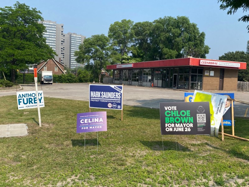
Last week Monday, I was at Spacing’s election night party at a pub in the Annex, watching the results of the election roll in after 8PM. Public polls consistently saw former Toronto city councillor and NDP MP Olivia Chow leading an especially crowded race of 102 candidates for mayor. It was the most exciting election I’ve followed since at least 2014.
Former three-term councillor Ana Bailão, one of former mayor John Tory’s protégées, was consistently in second place, followed by former Toronto Police Chief (and provincial PC candidate) Mark Saunders, sitting councillors Josh Matlow (who ran as a progressive) and Brad Bradford (who ran to the right), and right-wing columnist Anthony Furey. Though Bailão, a centrist, had the endorsements of multiple sitting councillors, Liberal MPs and MPPs, and several public and private sector unions, she had difficulty positioning herself as the presumptive centre-right challenger, especially with Premier Doug Ford backing Saunders.
It was not until the advance polls had closed that Deputy Mayor Jennifer McKelvie, the Toronto Star Editorial Board, and then Tory himself endorsed Bailão, likely spooked by Chow’s continued lead. (David Rider and Ben Spurr at the Star wrote a great article about the leadup to Tory’s endorsement.) Tory, who resigned after admitting to a long-term city hall affair, hummed and hawed over providing his endorsement, and hid from reporters even while robocalling Torontonians pleading them to vote for his appointed successor.
It is quite possible that Tory’s endorsement came too little, too late for Bailão. Nearly 150,000 electors (representing 21.7% of all votes cast) already voted in advance polls or by mail, and their votes were locked in. But the late push for Bailão was able to convince at least some election day voters to choose strategically — the percentage of voters who chose Saunders, Furey, and Matlow fell, while Bailão’s share grew on election day. Indeed, Bailão placed first among election day voters. But Chow, whose campaign encouraged advance voting, carried the day in the end.
For example, Josh Matlow placed a close second in Ward 12 in the advance polls (with 30.6% of the vote), where he’s a popular local councillor. On election day, Matlow placed third behind Bailão and Chow, with Chow eking out a narrow win overall there. In every ward, Chow placed first in the advance polls, but when all votes were counted, she placed first in 14 of the 25 wards. The table below shows how the vote shifted.
Table of ward-level mayoral byelection results, showing advance poll and election day results for the leading five candidates. PDF version here.
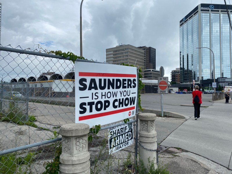
Chow won with 269,372 votes (37.2%) to Ana Bailão’s 235,175 (32.5%). Saunders, Ford’s pick, got just 8.6% of the vote despite his positioning as the only candidate to “stop Chow.” Furey placed a distant fourth, with 5%, and Matlow got 4.9%, acknowledging that Bailão’s late surge draw support away from him and towards Bailão and Chow. Brad Bradford was the biggest loser of the night, netting just 1.3% and placing fifth in his own ward.
“Saunders is how you stop Chow” sign
Though I was skeptical of Olivia Chow’s second run for mayor after an uninspiring run against Rob and Doug Ford and John Tory in 2014 (she placed third), she proved herself worthy this time around. She was more relaxed, more herself, and certainly tapped into a desire for change after eight years of Tory’s dull austerity and four years of chaos under Rob Ford (enabled by his brother Doug).
I fear Toronto’s political establishment — both Conservative and Liberal — will try to make Chow’s term as mayor difficult, even though their low-tax, low-spend agenda caused many of the problems that she will have to tackle. But for now, I’m pleased we will try it her way.
I created an interactive map showing the results of the election at the ward and electoral subdivision (poll) level. For the wards, I provided information on the advance and election day poll results.
Note that not all polls are mapped. Until the City of Toronto releases revised electoral subdivision boundaries (I suspect due to poll consolidations), there are some missing polls. However, 95% of all polls are depicted, and the results are interesting.
I look forward to your feedback as well; I approve all reasonable comments and reply to most emails.
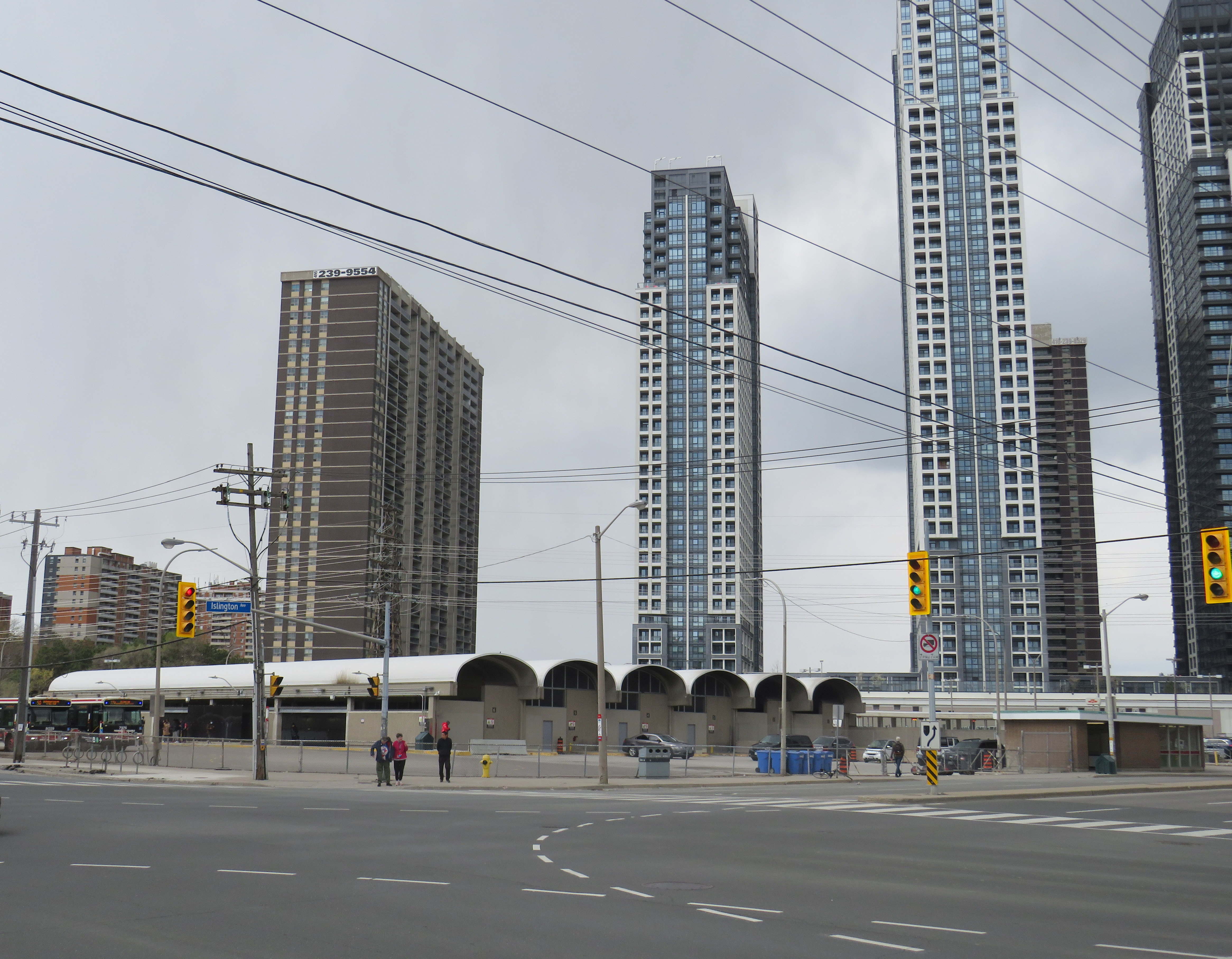
Islington Station, opened in 1968 as part of a major expansion of the Toronto subway system into Etobicoke and Scarborough, is now literally falling apart.
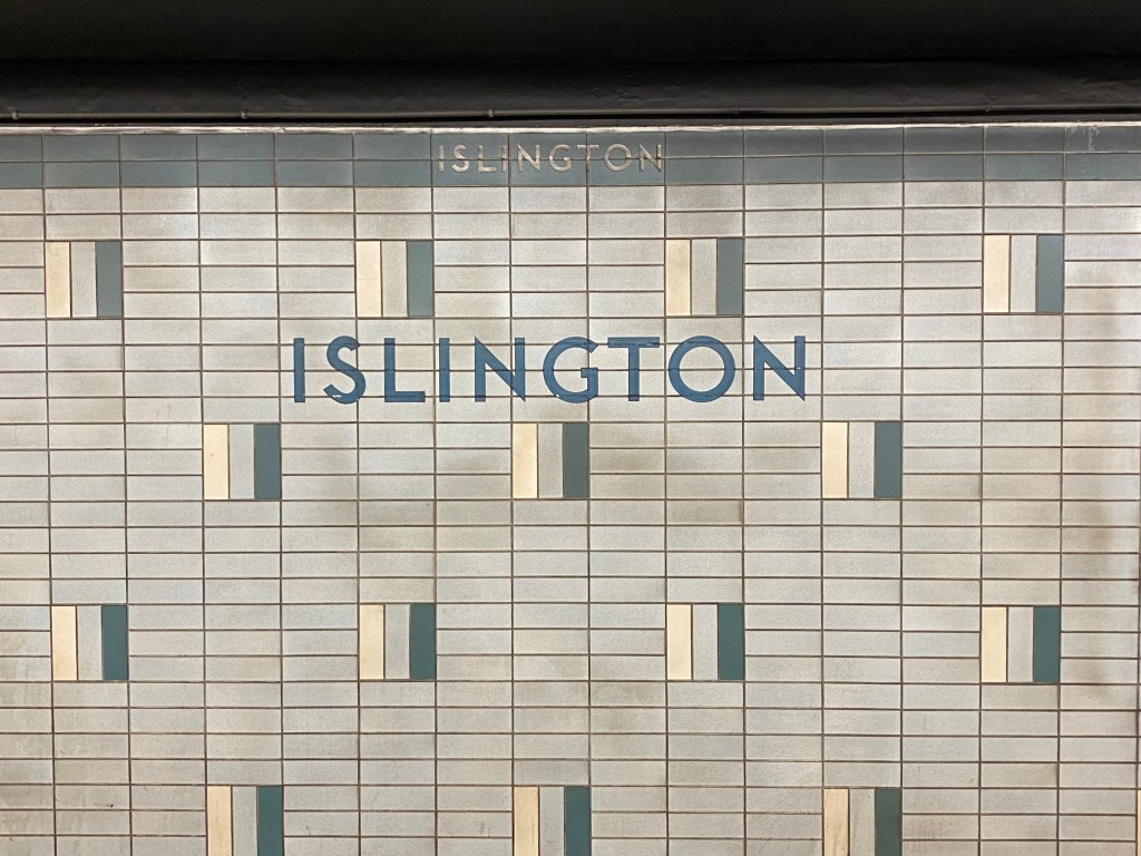
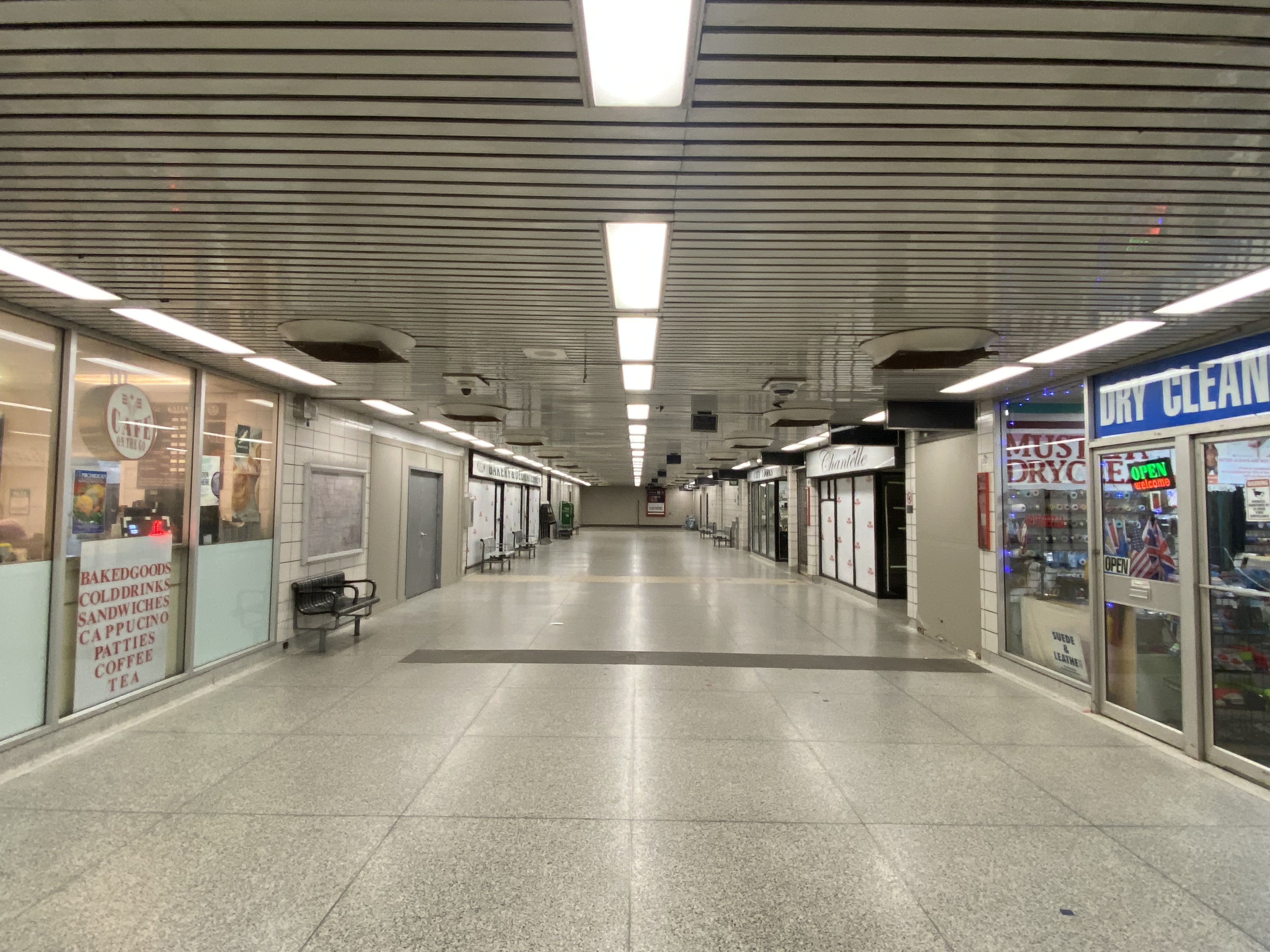
At platform level, Islington looks little different than most stations on the Bloor-Danforth Line with the faded wall tile, coated with a layer of brake dust. Upstairs, on the concourse level and the old bus terminal, the station is in far worse shape. Wear and tear from hundreds of buses entering and exiting the station every day, along with water seepage from an underground stream, has caused the station to look much older than it actually is.
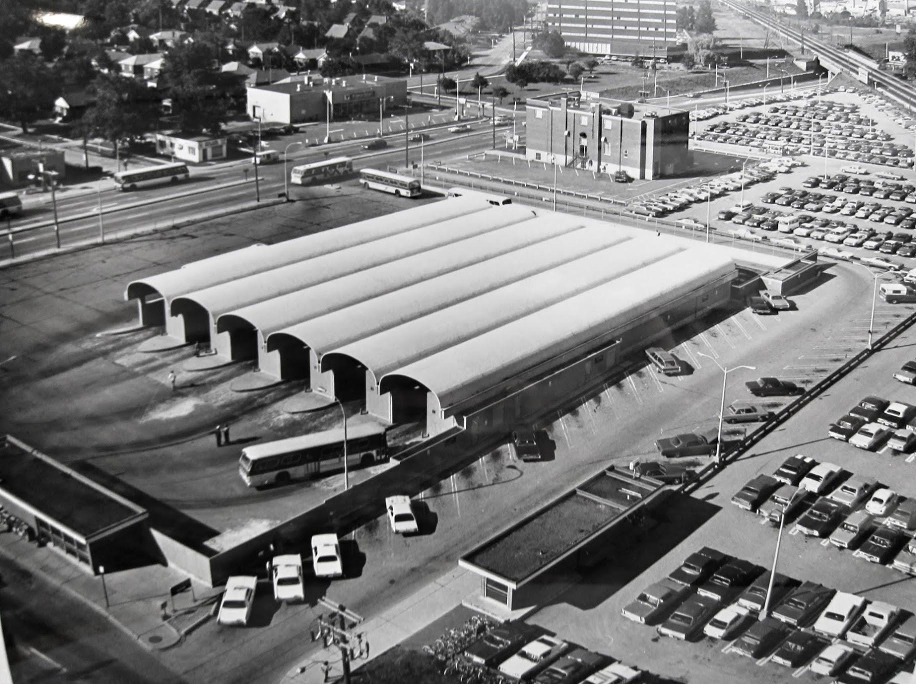
From 1968 to 1980, Islington Station was the Bloor-Danforth Line’s western terminus, with buses branching out to points all over Etobicoke. The bus terminal boasted six bus bays, each with its own driveway. One of the six platforms was dedicated for Gray Coach services, which included an express bus to Pearson Airport.
An arriving bus would first pull into the east side of the terminal, with all passengers descending a set of stairs to the subway concourse, either to transfer to the subway, exit the station, or transfer to another bus route. The bus, once the operator took their break, would then pull forward to the boarding area, where a second set of stairs emerged from a waiting area. Below, on the concourse level, a flashing light would alert waiting passengers that their bus was boarding. The terminal design was similar to the original bus terminal at Eglinton Station; at Warden Station, the levels are reversed, with the bus bays below the passenger concourse.
Aerial view of Islington Station’s bus terminal in 1975, City of Toronto Archives, Series 836, Subseries 4, File 46. Note the Mississauga Transit bus passing by on Bloor Street. Looking northwest toward the sealed-off bus terminal, May 2023
In 1980, the subway was extended one stop westward to Kipling. The extension allowed the TTC to reroute most of its Etobicoke routes from Islington, which provided new space for Mississauga Transit, whose buses now loaded inside the bus terminal. (As the bus bays are inside the station’s fare-paid area, Mississauga Transit buses off-loaded passengers outside the station’s main entrance on Islington Avenue.) A seventh bay, located to the south of the original structure, was added to provide additional capacity for Mississauga Transit, however, only simple bus shelters provided protection from the rain and snow.
But by 2016, the bus terminal area was starting to crumble, and bus bays 1 and 2 (the bus bays closest to the subway platforms) were closed permanently to prevent further structural damage. Mississauga and GO Transit planned for a new terminal adjacent to Kipling Station, but it was delayed by several years. Part of the delay was caused by Hydro One — owner of the transmission lines that parallel the subway and adjacent Canadian Pacific Railway corridor — who refused to allow a terminal building under its wires.
The opening of the new Kipling terminal for GO and Mississauga Transit buses in May 2021 (repositioned to avoid the hydro corridor) allowed the TTC to permanently close the crumbling bus terminal bays. All remaining buses — 37/937 Islington, 50 Burnhamthorpe, and 110 Islington South — began only using the outer bus loading area in late 2021.
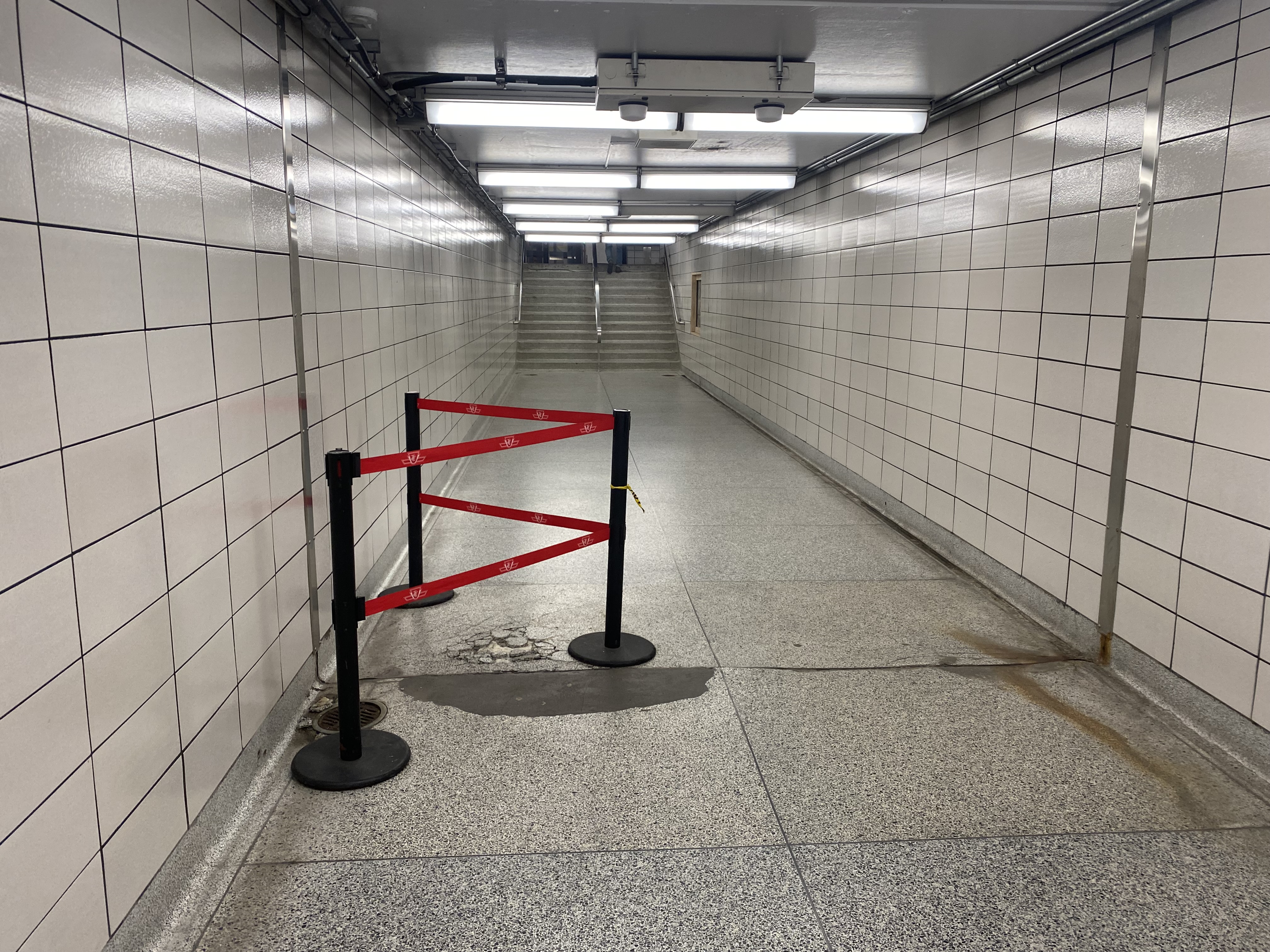
Bus passage, Islington Station. Stairways to the old bus bays are sealed off, with the signs above the old stairways blacked out. Passengers transferring to TTC buses must walk to the far end of this corridor and then up a stairway to access the outer bus bay.
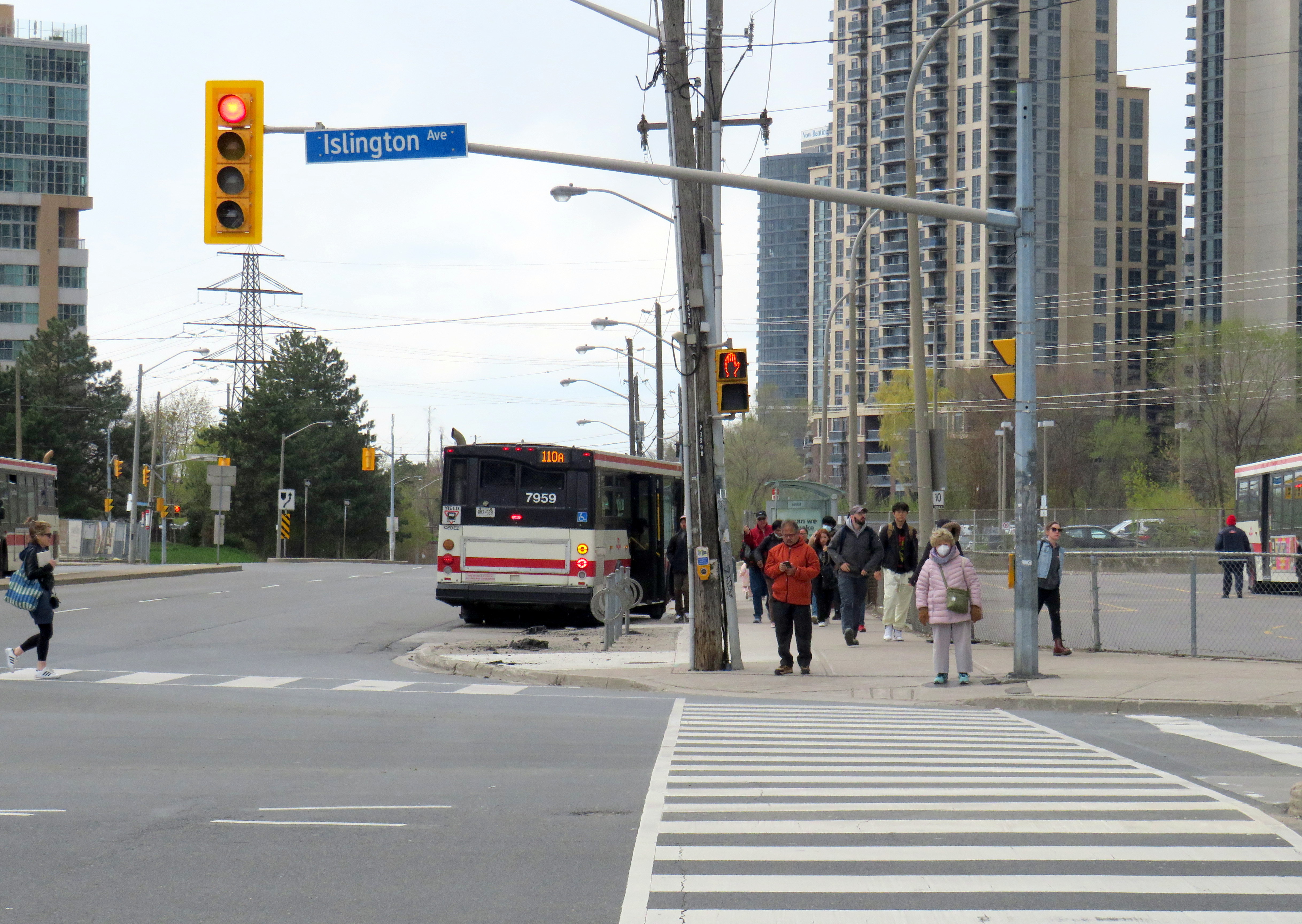
With little room remaining for buses to load, offload, and layover, passengers on TTC buses arriving at Islington are now let off on the street and must walk to the main entrance and show their transfer or tap their Presto card to enter the subway or transfer to another bus. Though Route 37/937 and 50 buses stop right in front of the station entrance on Islington Avenue, Route 110 buses off load on Bloor Street, a two-minute walk to the subway entrance.
A Route 110A Islington South bus off loads on Bloor Street; passengers must walk north to the subway entrance on Islington Avenue, to the right of this photograph
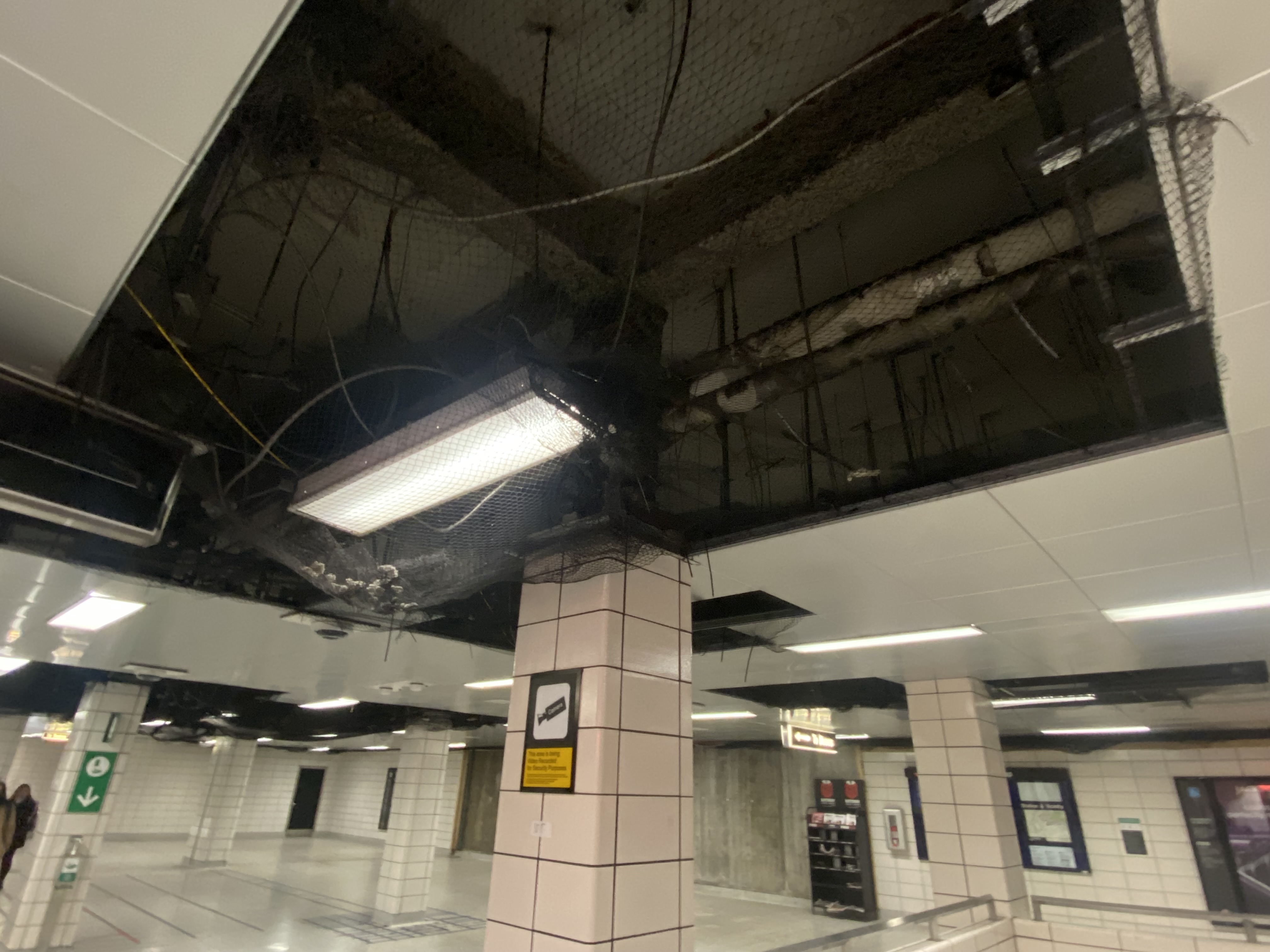
Since the bus terminal closure, the decay at Islington Station has extended beyond the bus area. On the mezzanine level, ceiling tiles were removed, while black netting catches chunks of broken concrete. Removed wall tiles reveal crumbling concrete and exposed rebar. Water leaks cover the mezzanine floor. There are no signs advising passengers of work underway or future construction, though there have been several plans to rebuild the station and promote new development on the site.
Fare gates partially obscured by temporary columns
Not only is reconstruction needed to rectify the deteriorating state of the station, Islington is also one of 15 subway stations that still do not have barrier-free access for passengers using wheelchairs or other mobility devices. Islington and Warden were left at the bottom of the list for station retrofits largely due to the difficulty of providing barrier-free access. The outdated bus terminal layouts at those stations require complete redesigns, and both stations are good candidates for urban development.
Netting keeps chunks of concrete from falling onto passengers’ headsCrumbling terrazzo floor in the passageway underneath Islington AvenueWater leak on the concourse level
There have been several proposals for redevelopment at Islington, taking advantage of its large bus terminal area and parking lot. The city first looked at redevelopment in 2006. At that time, there was a proposal from engineering firm SNC-Lavalin for a new office building that would incorporate a rebuilt station. However, that proposal deal fell through.
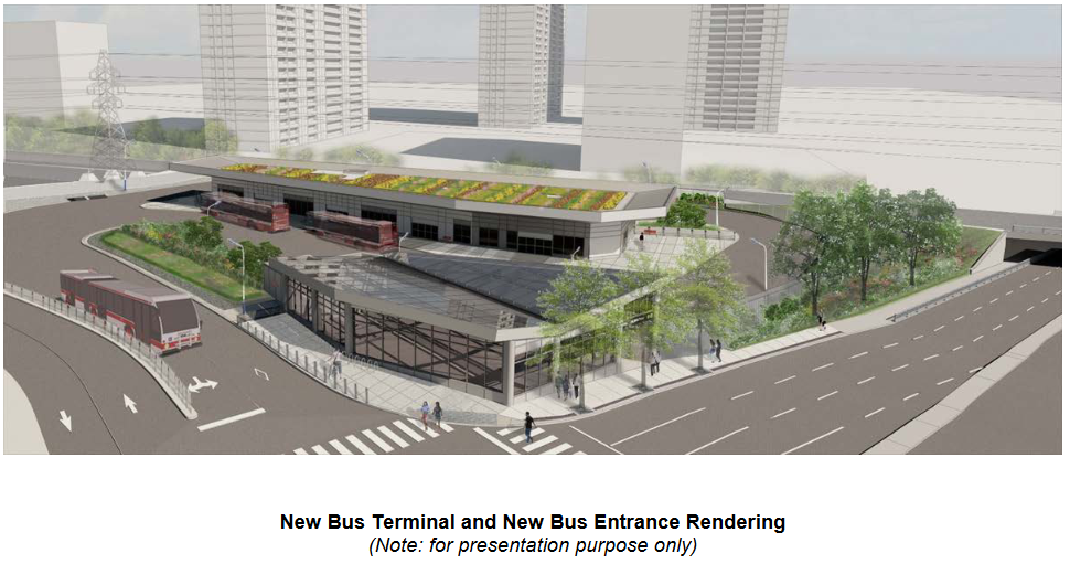
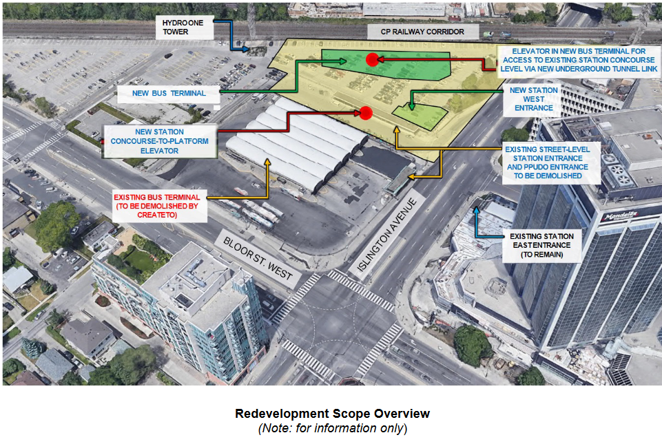
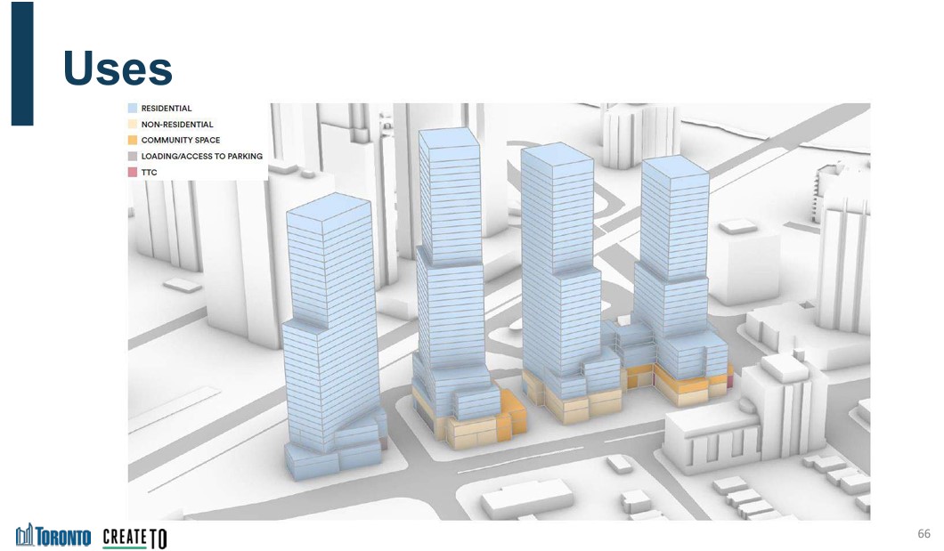
In 2021, a new plan to rebuild the station was presented to the public. It would include a new six-bay bus terminal in the commuter parking lot north of the existing terminal. Upon completion, the old bus area would be redeveloped under the city’s CreateTO housing program. Aberfoyle Crescent, which connects Islington Avenue and Bloor Street, would be extended through the station property to provide bus access and allow for development of the rest of the station property. The site is constrained by the same Hydro One corridor that stymied construction of the new Kipling terminal (much of the parking lot is under hydro wires), but this is a much smaller bus terminal, and hopefully lessons were learned this time.
Work on station construction was scheduled to begin in Spring 2023.
Rendering of new bus terminal and station entranceSchematic of the TTC station redevelopmentCreateTO development blocks at Bloor and Islington, from 2021 presentationCreate TO conceptual plan for Islington Station site
It is now mid-June 2023, and for now, there is no sign of work. Inside the station, there are no signs informing customers of impending construction, even if only to reassure passengers that the decrepit conditions are being addressed.
The many delays at Islington Station are also indictive of the difficulties of redeveloping even city-owned properties for new, much needed housing. It won’t be until 2026 — at the earliest — that new development can take place.
Until then, TTC customers must put up with a rapidly deteriorating station.
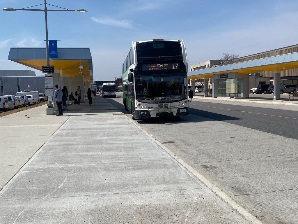
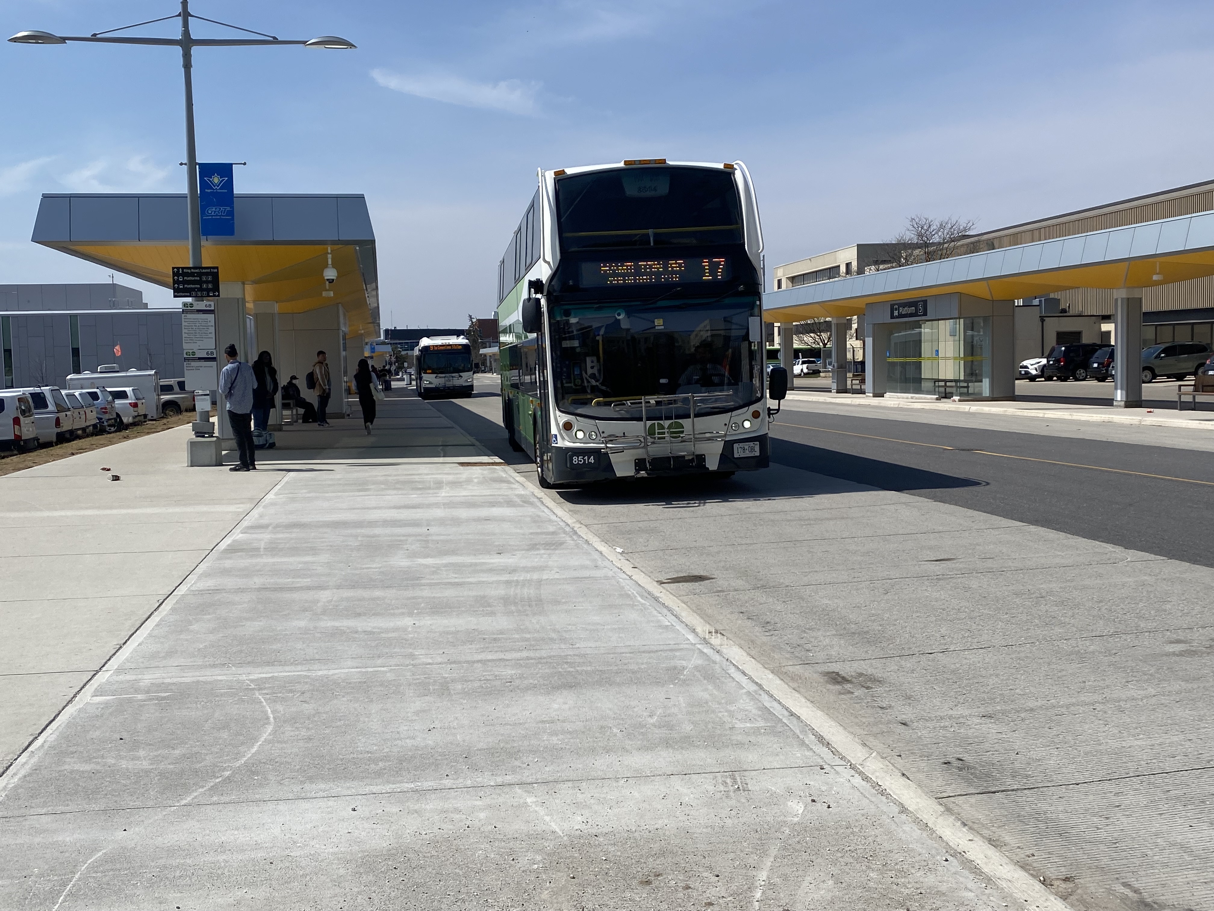
Route 17 bus arriving at University of Waterloo Station
On Monday, April 10, 2023, GO Transit filled a big hole in Ontario’s intercity transportation web with Route 17, which connects three major urban centres, four universities, and two existing GO Transit rail corridors. On that day, I made my way to Waterloo and rode one of those first buses south towards Hamilton. Nearly a month later, I made a second trip, from Guelph and Downtown Hamilton, on May 5.
Sign post at University of Waterloo indicating the stops for Route 17
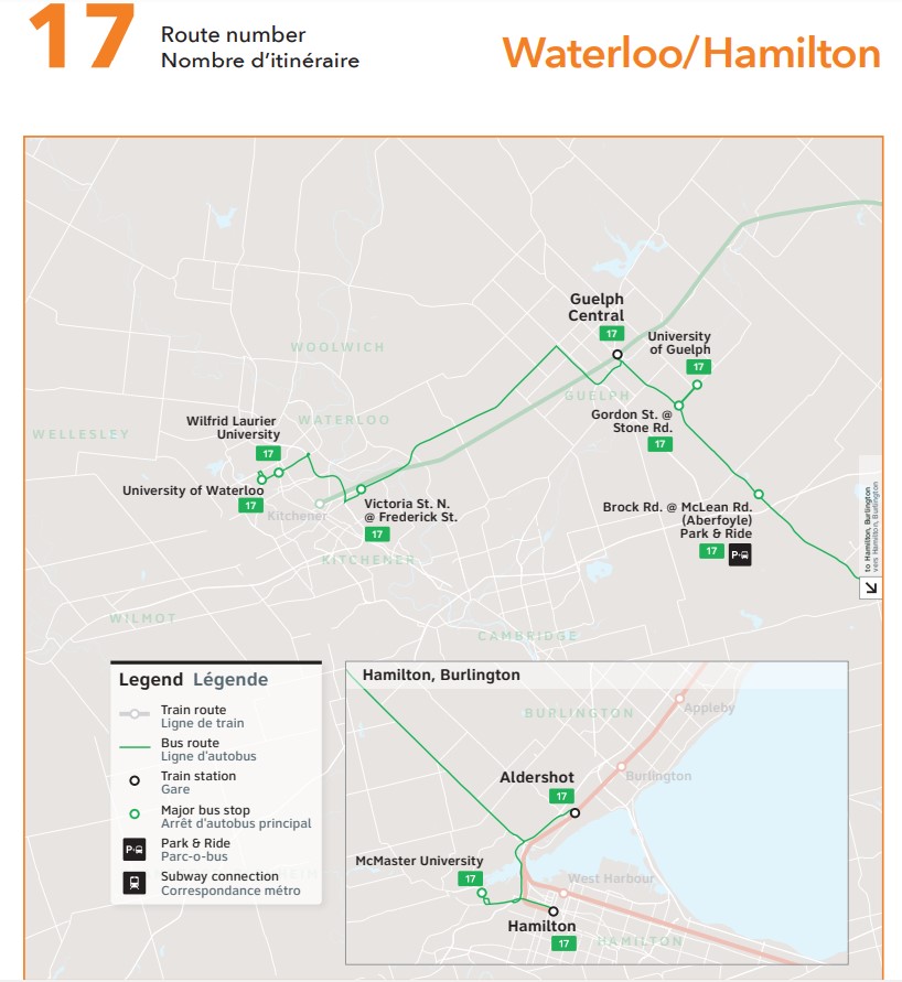
The bus originates at the new University of Waterloo bus terminal, located adjacent to the Ion LRT corridor and on the far east side of the university campus. It then stops in front of Wilfrid Laurier University, on Victoria Street North in Kitchener’s east end, at Guelph Central Station, University of Guelph, the park & ride lot in Aberfoyle, Aldershot Station, McMaster University, and Hamilton GO Centre.
Waterloo-bound Route 17 bus at Guelph Central Station, May 5, 2023
On the first day, the experience was more interesting than I expected, as the driver, new to the route, missed the turn from the Hanlon Expressway (Highway 6 through Guelph) towards Downtown Guelph. Luckily, dispatchers were able to guide the driver back on route after a short delay, so it only made for a roundabout tour of some of Guelph’s residential neighbourhoods, where GO Transit has certainly not gone before (and probably won’t, ever again).
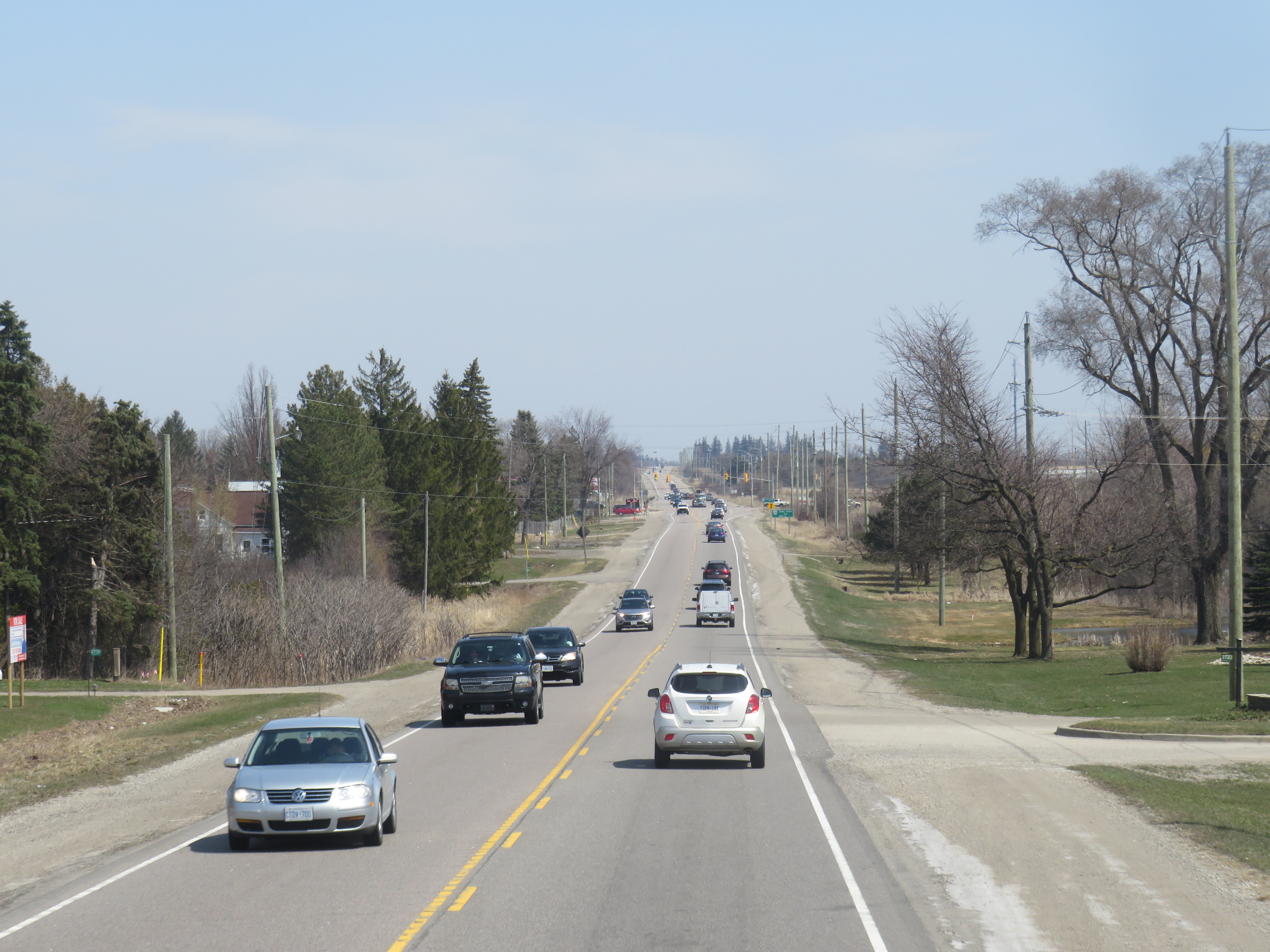
On congested Highway 7 between Kitchener and Guelph
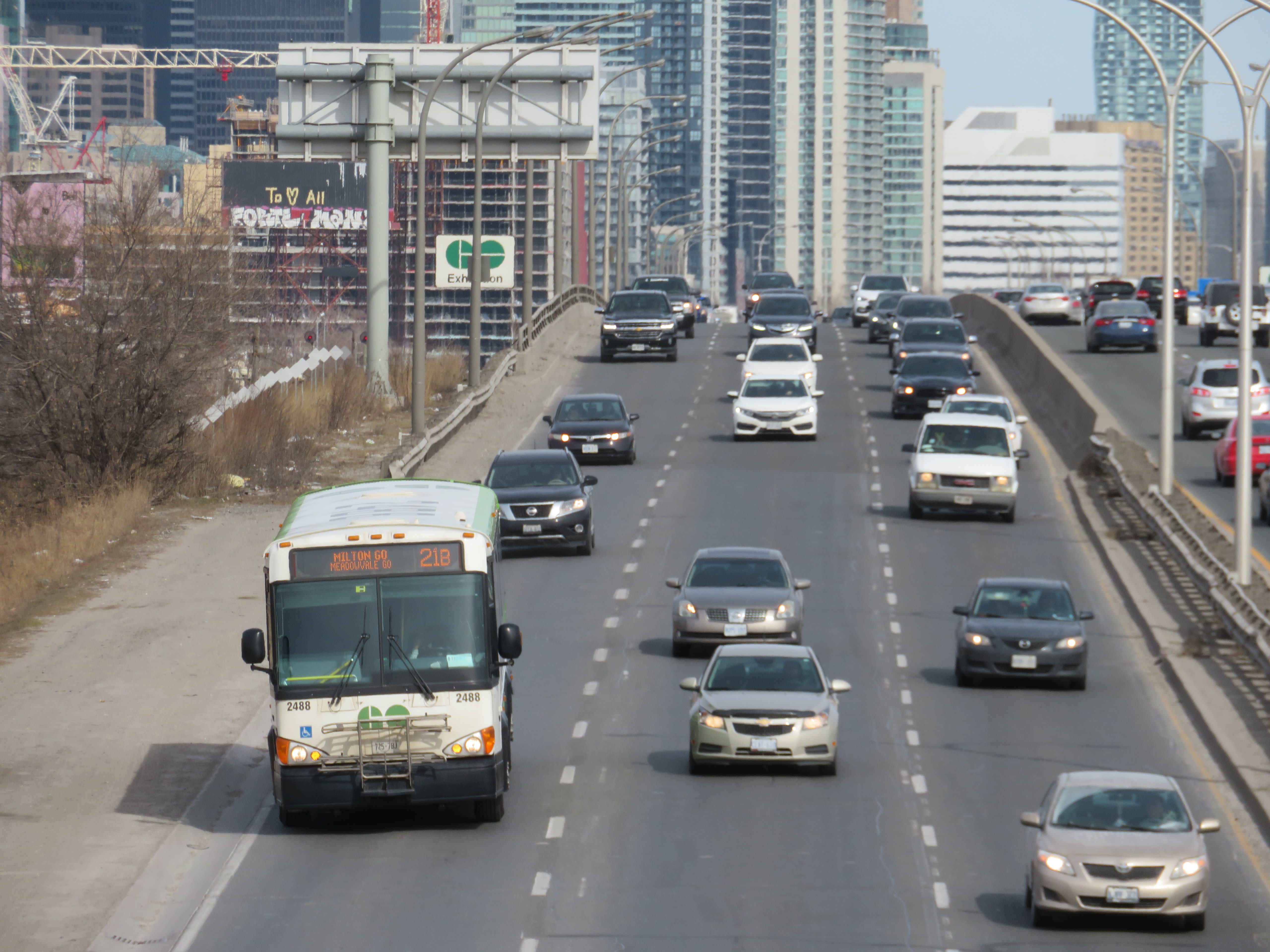
Sitting at the top of the front of a double decker bus (so far, I had my choice of seats as the route is still new and not too busy) gave me a view of the traffic congestion in the western Greater Golden Horseshoe. Highway 7 between Kitchener and Guelph is still a two-lane road, without even paved shoulders to make it a bit more cycling friendly. Though there are a few GO trains on the adjacent railway, the service is sporadic and only runs on weekdays. A new four-lane freeway has been planned for decades, with some preliminary work started, but a regular two-way, all-day train service, and more bus links to places like Cambridge, would be even more effective in meeting travel demands in the region.
Highway 6 south of Highway 401 is also very congested, and a new highway bypass is planned to divert traffic around a two-lane section through Morriston and Puslinch Station. Clearly, there’s a lot of travel demand between Kitchener-Waterloo, Guelph, and Hamilton, but transit options have always been severely limited.
Thankfully, Metrolinx is upgrading the western portion of the Kitchener Line, with a second platform under construction at Guelph Central Station, and work started on new passing sidings between Kitchener and Georgetown. But it will be several years at least before the upgrades allow for regular, two-way, daily passenger rail, so the bus will have to do.
At Aldershot Station
In my review of GO’s service changes earlier this month, I argued that Route 17 was trying to do too much with a single bus route. Riding the corridor from end-to-end (albeit on two separate occasions), I could not help but feel frustrated by the southern end of the route, where the GO bus goes east on Highway 403 to connect with Aldershot Station, then backtracks to get to McMaster University, then turns around to get to Downtown Hamilton. I understand that all three destinations are important trip generators (Aldershot allows passengers from Burlington, Oakville, and southern Mississauga to get to Guelph and Waterloo, McMaster University is a reliable trip generator, and Downtown Hamilton is a busy urban hub), but for someone to get between Hamilton and Guelph or Waterloo, it’s a long way out of their way.
I am hopeful that GO Transit uses the summer down time to see where passengers are going and coming from and make route adjustments or add express runs once classes resume in September.
Map of GO Transit Route 17
A note on Route 21
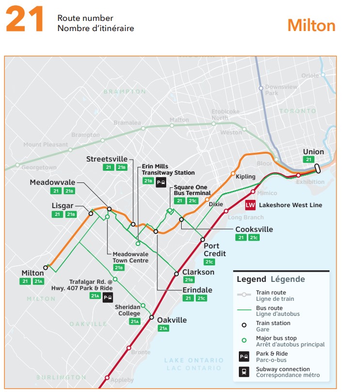
Last month, when previewing the new GO Transit changes, I discussed the changes to Route 21 (the Milton Corridor train-bus service), in which most buses were pulled from Union Station, instead diverted to three stations on the Lakeshore Line. Though at the time, I explained that the change made sense given severe traffic delays on the Gardiner Expressway and around the new GO Bus Terminal, it would mean a longer trip, and an unpopular transfer.
I underestimated the aggravation and anger transit riders had when the new schedules were put into service. The loss of direct GO bus service between Milton and Mississauga along Derry Road is also a new gap that should be re-filled.
I suggest three changes, though I acknowledge that the continued shortage of train crews and budget issues might make these more difficult:
Restore 15-minute rail service on the Lakeshore West corridor. This would at least ensure that transferring Route 21 customers aren’t stranded up to 30 minutes at Oakville, Clarkson, and Port Credit stations. Since GO Transit’s ridership has recovered faster off-peak versus peak periods, the extra capacity will be helpful.
Restore all-day, regular bus service on Derry Road between Milton and Meadowvale, perhaps extending to Bramalea Station and/or Highway 407 terminal. This would provide new connections, including the new weekend Kitchener Line trains.
Extend more buses between Square One and Kipling Terminal. Though the new Kipling Station bus terminal was a Metrolinx project, only Route 29 (Guelph-Square One-Kipling) uses it. It could then be an alternative to transferring to Union Station for some passengers.
This section of the LRT, planned last decade, was narrowly rejected by Brampton City Council in a 6-5 vote, with then-mayor Linda Jeffrey supporting the transit line’s construction. Unfortunately, six city councillors sided with several downtown merchants and affluent Main Street South residents (including former premier Bill Davis), who did not support a surface tram on Main Street, back in October 2015.
In 2019, a newly elected council, led by a new mayor, Patrick Brown, was willing to revisit the LRT decision, again backing a direct Main Street alignment. City staff were directed to update the original, approved 2014 Transit Project Assessment Process (TPAP). In 2021, staff narrowed the alternatives to just two options: an all-surface alignment from Steeles Avenue to the GO station in Downtown Brampton, and an underground option between Nanwood Avenue and the rail corridor. Meanwhile, Brampton staff and elected officials tried, without success, to restore the north-side LRT terminal at Steeles Avenue/Gateway Terminal.
Now that the 30% design work for the two options is complete, city officials must decide how to proceed, especially if they expect senior levels of government to cover the costs of this major transit project.
The alignments
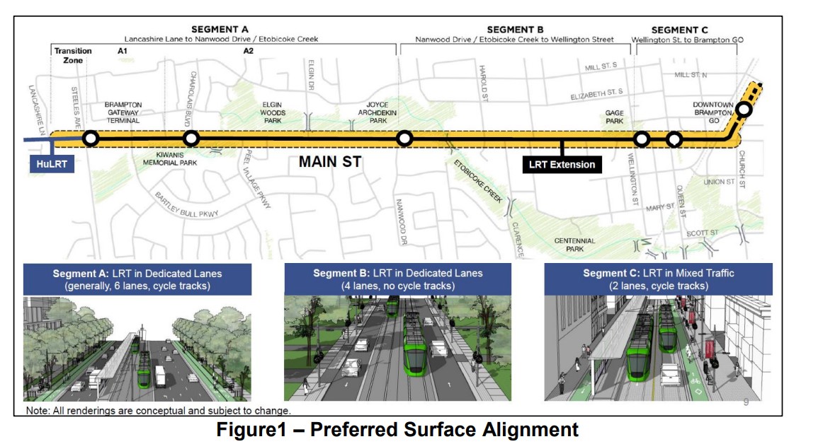
The all-surface alignment three stops in each direction between the Gateway Terminal at Steeles Avenue and the Brampton GO Station: at Charolais Boulevard, Nanwood Drive, and split northbound and southbound stops between Wellington and Queen Streets. These stop locations match the existing 502 Züm Main stops on this section of Main Street.
Between Nanwood Drive and Wellington Street, the LRT would operate in dedicated lanes, with general traffic in the outer two lanes. There would not be room for bicycle lanes, and left turns would be prohibited at non-signalized intersections. North of Wellington, the LRT would run in mixed traffic, with cycle tracks and widened sidewalks on both sides of the street.
The preferred surface alignment
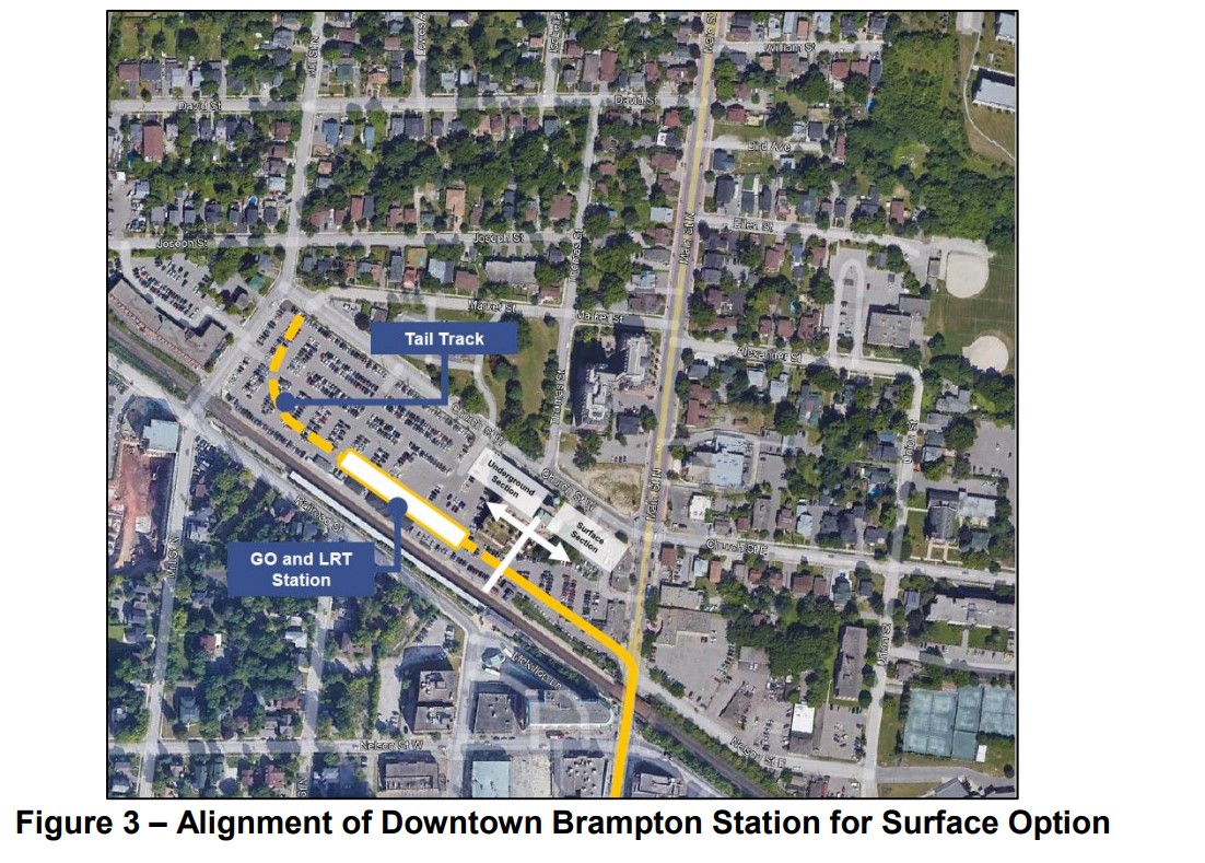
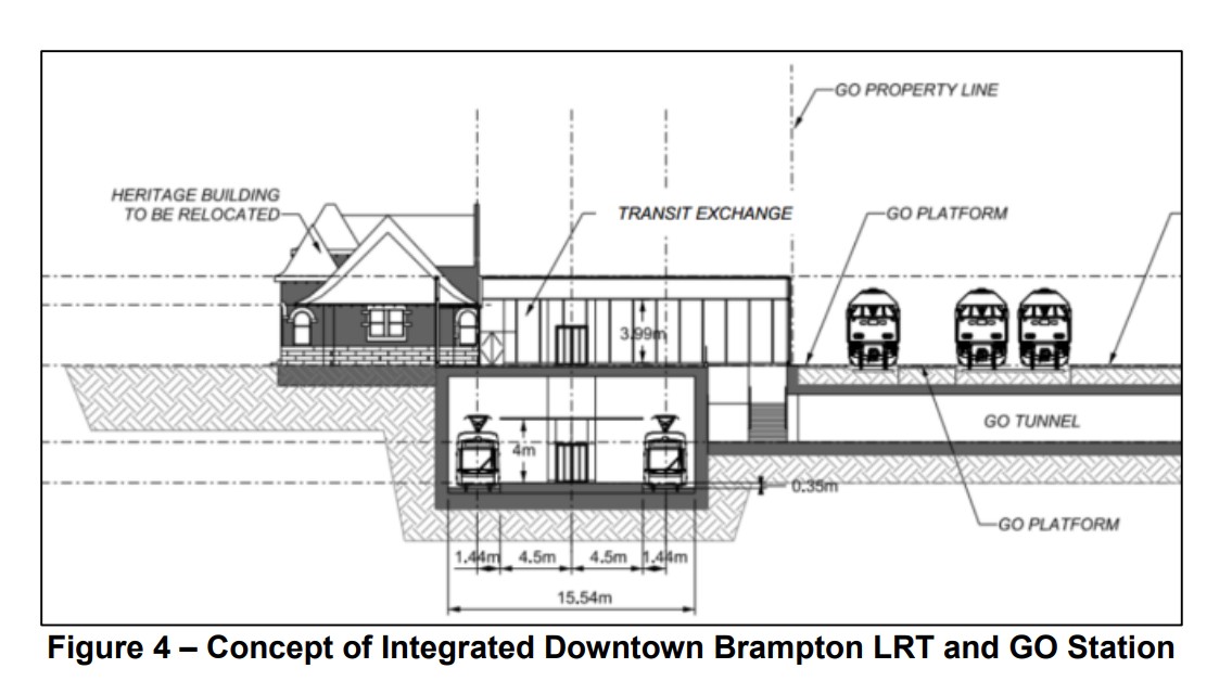
The northern terminus would be on the GO Station property, on the west side of Main Street, in a below-grade trench. Stairs and elevators would connect the platform with the GO Station, while the historic 1907 station building would be moved to support GO train service expansion on the busy CN freight corridor. The street surface would need to be lowered by one metre for the light rail vehicles and the overhead wire to clear the railway underpass.
Alignment of off-street surface LRT alignment on the GO Station property Design concept for the GO and LRT terminal
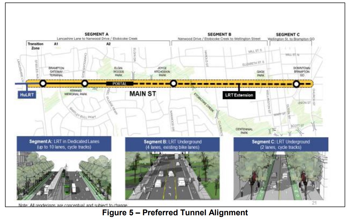
The tunnel alignment – which was not part of the approved 2014 TPAP – includes the same surface stops at Brampton Gateway Terminal and Charolais Boulevard, and two underground stations, at Nanwood Drive and the terminal, just south of the GO Station. Between Elgin and Nanwood, the tunnel would be dug in the traditional cut-and-cover method while the portion under Etobicoke Creek and the downtown core would be constructed using the sequential excavation method.
The tunnel portal would be located at Elgin Drive, several hundred metres south of Nanwood. The longer tunnel section is required to avoid the Etobicoke Creek floodplains. Though Nanwood Drive has no intersecting transit routes and relatively low density, the rundown Brampton Mall property would be an ideal urban development site, as would the commercial properties immediately to the south.
The preferred tunnel alignment
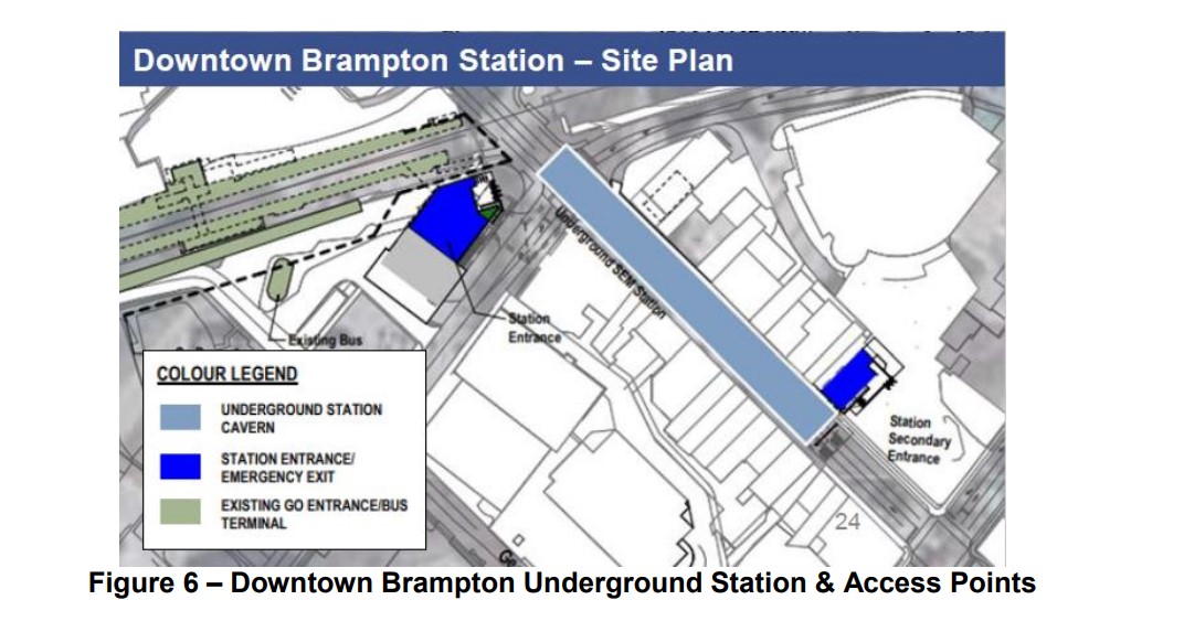
The downtown terminal station would include a primary access at the corner of Main and Nelson Streets, to provide access to the GO Station and the proposed new transportation hub, as well as a secondary entrance closer to Queen Street and Garden Square.
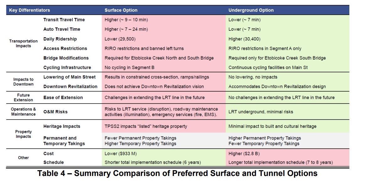
The two options were compared, putting the tunnel alignment ahead in all categories apart from cost and schedule. The tunnel would allow for continuous cycling infrastructure on Main Street, minimize traffic impacts, while having slightly higher ridership and somewhat faster transit. The tunnel would also better satisfy homeowners and businesses along the corridor. Staff also note that the tunnel alignment, without the bend into the GO station property, would be easier to extend farther north.
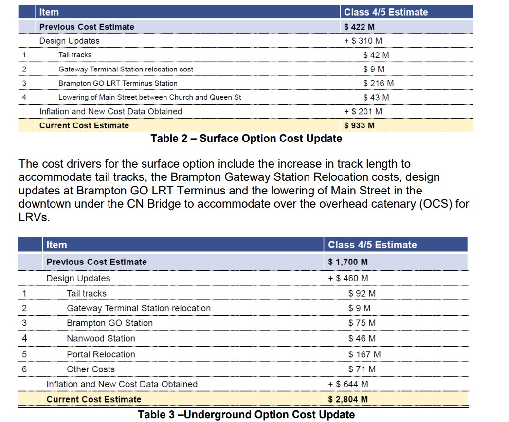
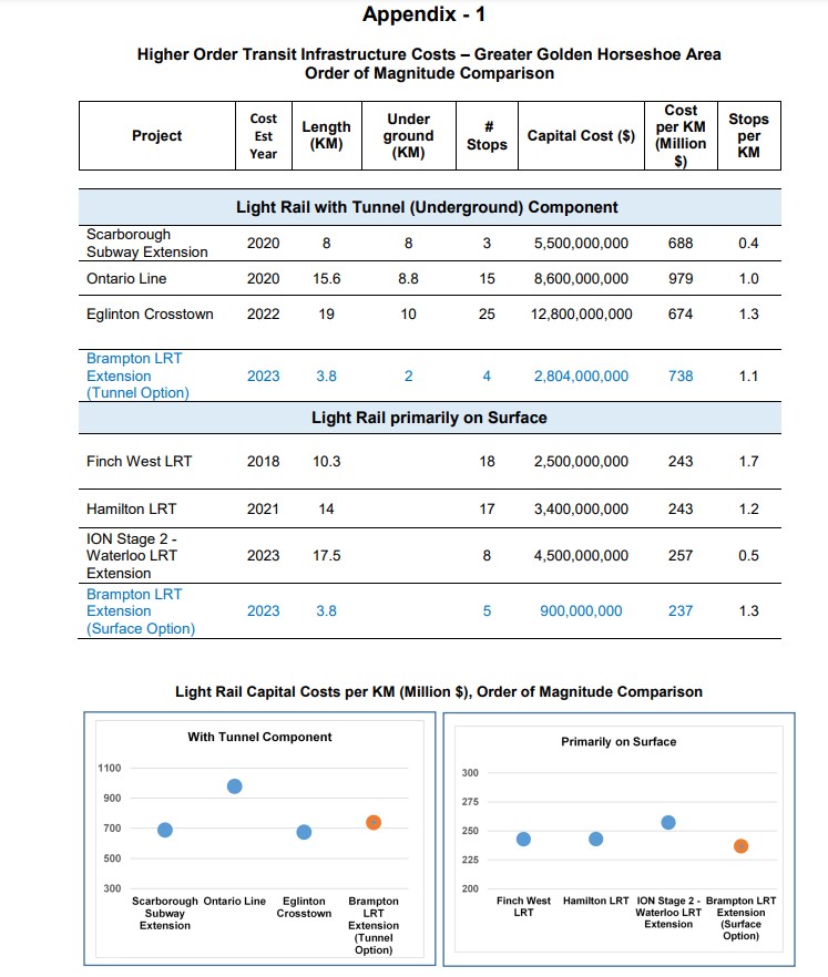
As with other transit projects, the costs of delaying this segment of the LRT are subject to inflation. The surface alignment would cost $933 million, while the tunnel route would cost $2.8 billion. The surface option would take one to two fewer years to complete, an important consideration given Brampton’s fast-growing transit ridership and delays on other complex LRT projects, such as the Eglinton-Crosstown line.
Cost comparisons for the tunnel and surface alignments
The Pitch
Towards the end of the staff report is a section called “Funding Advocacy.” Staff rightfully point out the need for the LRT extension, given the city’s and the province’s goals of directing high density development to the downtown core and other transit station areas, as well as the city’s record of continuous ridership growth and transit improvements.
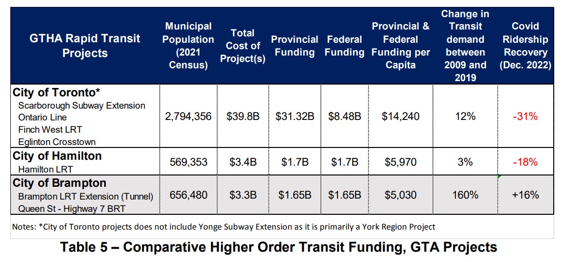
They also point out that the funding that Brampton is seeking (for the Queen Street BRT project and the LRT, specifically the tunnel option) is comparable to other transit projects in the Greater Toronto and Hamilton Area. The table below compares the costs and funding sought for Brampton’s proposed projects to those funded and underway in Toronto and Hamilton.
Table comparing costs, funding and system ridership for Toronto, Hamilton, and Brampton
An appendix to the staff report compares the cost of the tunnel option with other tunnelled Ontario projects (the Scarborough Subway Extension, the Ontario Line, the Eglinton-Crosstown), and the surface alignment with other surface projects (Finch West LRT, Hamilton LRT, Ion LRT extension in Cambridge).
Concluding thoughts
It is still a shame that Brampton City Council put the interests of a small, but affluent, minority of voters first back in 2015-2016. Had they not prevailed, the LRT into Downtown Brampton would have been under construction right now – at the same time that critical water infrastructure is being replaced in Downtown Brampton, and we would be looking forward to it being open in just two years. However, just three of the eleven council members that voted on the LRT in 2015-2016 remain at Brampton City Hall, and two of those three councillors supported the original project.
The arguments in favour of the tunnel are enticing: a faster transit ride though a congested part of the city, an appeal to provincial and federal governments that have historically short-changed Brampton on its infrastructure needs, in a city that will have six seats up for grabs in the next elections.
However, a surface LRT will be quicker and much cheaper to build. I also do not see the need for further extensions northward, at least via Main Street, and even then, it would require a second tunnel portal somewhere near Vodden Street, adding at least $1 billion to future costs. The GO station terminal points towards the abandoned Orangeville-Brampton Railway, which could provide a good alignment northward from Downtown Brampton, even with a parallel cycling path.
More than anything, I want to see the Hurontario-Main LRT completed to Downtown Brampton as soon as possible, especially as work progresses on all-day hourly train service between Toronto and Kitchener and revitalization and intensification of Downtown Brampton accelerates.
The provincial government has signaled that they prefer the surface alignment for cost reasons (notwithstanding it spending billions of dollars on an unnecessary tunnel on Eglinton West in Etobicoke), as does the Brampton Board of Trade. It is also worth noting that this study is only at the 30% design phase, detailed engineering work may find further costs.
The surface option was the right choice in 2015, and it remains the right choice today. This time, maybe, Brampton will get it right.
GO Transit bus on the Gardiner Expressway. Route 21 will se major changes with the new schedules
On Saturday, April 8, GO Transit will introduce big changes to its rail and bus services. Brampton and Waterloo Region will see the biggest benefits, while a major gap in Ontario’s intercity bus network will finally get filled.
However, major construction work on the Barrie and Stouffville Lines will require the bustitution of most trains on those two corridors for at least a few months. Most buses serving the Milton Line will no longer operate to or from Union Station, but instead connect with the Lakeshore West Line. Finally, one of GO Transit’s oldest bus routes will finally disappear for good.
Though the scale of these service changes is truly impressive, there are some drawbacks that hopefully will be addressed in the near future.
As part of the April 2023 changes, GO Transit will finally introduce hourly weekend service on the Kitchener Line between Union Station and Mount Pleasant GO in northwest Brampton. Most Route 31 “train-bus” trips will be cancelled, while Route 33 (Guelph-Brampton-North York) takes over the Guelph via Highway 7 service completely.
With the exception of weekday counter-peak periods, early mornings, and late evenings (when Route 31 will still operate), Brampton finally has the all-way, two-way, every day train service it has been requesting for decades. Because of schedule constraints, and limited track space, weekend trains will not be stopping at Etobicoke North.
Route 30, the Bramalea-Kitchener-Waterloo bus, will also operate 7 days a week, with an easy transfer at Bramalea GO Station. This is the fastest and most frequent service between Toronto and Kitchener-Waterloo (private intercity bus service to Kitchener are limited, and they only stop at Sportsworld, near Highway 401), and should help build ridership for future train service expansion.
Unfortunately, there remains no quick GO bus service between Toronto, Brampton, and Guelph; passengers must still endure the Route 33 milk run on Highway 7 through Georgetown, Acton, and Rockwood. Weekend service on Route 48, the Guelph-Bramalea-Highway 407 route, timed to connect to Kitchener Line trains, could provide this useful link until track capacity is improved west of Bramalea and through Halton Region and Wellington County.
The introduction of GO Transit Route 17 between Kitchener-Waterloo, Guelph, and Hamilton is, in my view, even more significant than the new weekend train service on the Kitchener Line.
This new bus route is the first time a GO Transit service has gone against its 55-year-old business model of a Toronto-centric system, where all train services converge on Union Station, and all bus services supplement the train corridors or connect to a suburban Toronto terminal. This might even be the most significant GO Transit service change since the first Highway 407/York University bus service began in September 2000. The 407 Corridor, originally a single bus route connecting Oakville, Mississauga Square One, Bramalea, York University, and Markham, has expanded into a multi-branched 24-hour/7-day corridor that now extends to Oshawa, Guelph, and Hamilton.
Route 17, which will run hourly on weekdays, directly serves four university campuses (University of Waterloo, Wilfrid Laurier University, University of Guelph, and McMaster University), a record for any single bus route in Canada (only the TTC Yonge-University Subway serves as many university campuses in a one-seat ride). It also provides a direct Guelph-Kitchener-Waterloo link (which was only provided by infrequent Greyhound buses before 2020) and replaces former Coach Canada/Megabus routes abandoned prior to or during the COVID-19 pandemic.
Though Route 17 finally fills several gaps in the Greater Golden Horseshoe, it is, at best, a first good step.
For one thing, Route 17 is too slow to effectively serve as a great Kitchener-Waterloo/Hamilton connection. The travel time from University of Waterloo to Downtown Hamilton is between two hours and twenty minutes and two hours and thirty minutes. The typical driving time is about one hour. It is more competitive between Guelph and Hamilton, though the route diverts to Aldershot GO Station to connect with the GO Transit Lakeshore West corridor, adding 15-20 minutes of travel time over a direct McMaster/Downtown Toronto routing.
Finally, there is no weekend service offered at this point, and the new route misses Downtown Kitchener, diverting via the Conestoga Parkway, though a stop at Victoria and Frederick Streets east of downtown provides connections to several GRT bus routes. There is also a need for better connections between Cambridge and Guelph, something that GRT, Wellington County, and Guelph should work together to fix.
I am hopeful that the new hourly weekday service is attractive to students and commuters, and that ridership grows to a point that GO considers weekend service and either express runs, or a restructuring of the corridor to provide more direct services.
Route 21, the Milton GO bus corridor, provides Milton-Mississauga-Toronto service at all times except the weekday peak period direction, when GO operates seven trains between Milton and Union Station. Unfortunately, the busy Milton Corridor is Canadian Pacific’s mainline between Toronto and Chicago. Unlike CN (whose mainline is used by GO’s Kitchener Line between Bramalea and Georgetown), CP has been less amiable to GO service expansion outside the peak period window.
Because of passenger demand in central Mississauga, Route 21 has traditionally been one of GO Transit’s most complex routes, with ten distinct branches, with service to each station every 15-30 minutes at most times. With increasing traffic into and within Downtown Toronto, especially on summer weekends, Route 21 can be very slow and unreliable, with GO Transit forced to divert its buses on Route 21 and 31 away from its Union Station Bus Terminal to Port Credit GO.
Though weekend train service on the Kitchener Line solves the problem for Route 31, without access to CP’s tracks, Milton Line passengers must ride buses, which have to go somewhere.
The solution, then, was to permanently divert Milton Line buses to the Lakeshore West rail corridor. Route 21A will operate between Milton GO Station and Oakville GO Station, serving Sheridan College’s Oakville campus and the 407 Corridor at Trafalgar Road (allowing for new transfers from Milton to Hamilton/McMaster and Mississauga/Pearson Airport). Route 21B will run from Lisgar GO, serving Meadowvale GO, Streetsville GO, and Erin Mills Transitway Station before connecting to trains at Clarkson GO. Route 21C runs between Erindale GO, Square One, Cooksville GO, and Port Credit GO. Only during early mornings and late evenings will Route 21 serve Union Station, making all stops to and from Milton.
Dixie Station also loses its weekday Route 21 service. The station is not well connected with local transit nor is it in a walkable area, so it is completely dependent on drive-up traffic. That should be fine for commuters who can rely on the regular train schedules, and who don’t need to leave Toronto early or late, but it worth pointing out.
These changes simplify Route 21, and provide a reliable and predictable, albeit slower, connection to Downtown Toronto. They provide new connections to the busy Highway 407 bus corridor, and allow GO to divert buses and drivers to other services.
One thing GO can do to improve the utility of its realigned bus service is operate the new branches at all time periods to maximize ridership. For example, Route 21A, while providing new useful links between Milton, the Highway 407 corridor, and Sheridan College, does not run in the peak direction when the Milton Line trains are running, with no southbound buses from Milton to Oakville between 5:03 AM and 9:28 AM. A similar gap exists northbound in the late afternoon on weekdays.
Other changes
The Stouffville Line, which enjoys hourly train service seven days a week, goes down to just peak period rail service starting April 8. Work to double-track the corridor through Scarborough has been continuing, albeit slowly, so hopefully the suspension of off-peak trains will help speed up construction. Work to expand the Lakeshore East/Stouffville corridor through Toronto’s east end has also forced train service reductions between Toronto and Oshawa.
Route 81, one of the older bus routes in GO Transit’s network, will finally disappear. The bus route, connecting Whitby GO Station, Port Perry, and Beaverton, has seen low ridership, with alternative service provided by Durham Region Transit’s Route 905 to Port Perry and DRT’s rural on-demand service.
Finally, though they are not amongst the major upcoming changes, GO Transit’s services to Orangeville and Peterborough remain inadequate. Route 37, between Brampton and Orangeville, still does not operate on weekends, nor is there a morning northbound bus from Brampton. Ironically, there is better service leading north from Orangeville towards Shelburne, Dundalk, and Owen Sound operated by Grey County’s rural bus system.
Meanwhile, Route 88, which connects Oshawa GO Station with Peterborough and Trent University, was diverted several years ago to serve Bowmanville, replacing since-cancelled Route 90. Unfortunately, this results in a long, nearly two-hour bus ride between Oshawa and Trent University, or four hours between Toronto Union Station and Trent. The drive, with moderate traffic, is less than half that. Though Rider Express now operates a bus from Toronto to Ottawa via Peterborough, it only runs once a day, four days a week.
It would be great if GO Transit could speed up Route 88 to make it a viable and attractive option between Toronto, Durham Region, and Peterborough.
Finally
On the whole, I am pleasantly surprised by GO Transit’s April service changes. Weekend service on Route 30 and the new Route 17 between Hamilton, Guelph, and Kitchener-Waterloo close some major gaps in that part of the province. The Route 21 changes make a lot of sense and open up new connections, though many bus passengers will not be happy with the new forced transfer to get to or from Downtown Toronto. Though bustitutions on the Barrie and Stouffville Lines are not ideal, they will allow for important work to improve rail service on those two corridors. Finally, attention to bringing faster and fuller service on some bus routes – like 21A, 37, and 88 will help build a complete transit network across the Greater Golden Horseshoe.
Across Canada, our biggest cities are building new transit. Here in Toronto, the Crosstown and Finch West LRTs are well underway (though the first phase of the Eglinton-Crosstown is already three years late), as well as the Scarborough subway expansion, the Ontario Line, and GO Transit corridor improvements. Vancouver is building a major expansion to its Skytrain network, the Broadway Subway. Ottawa, Calgary, and Edmonton are all expanding their LRT networks. And in Montreal, the first phase of the Réseau express métropolitain (REM) will open for service, while major work on the Blue Line Métro extension has just begun.
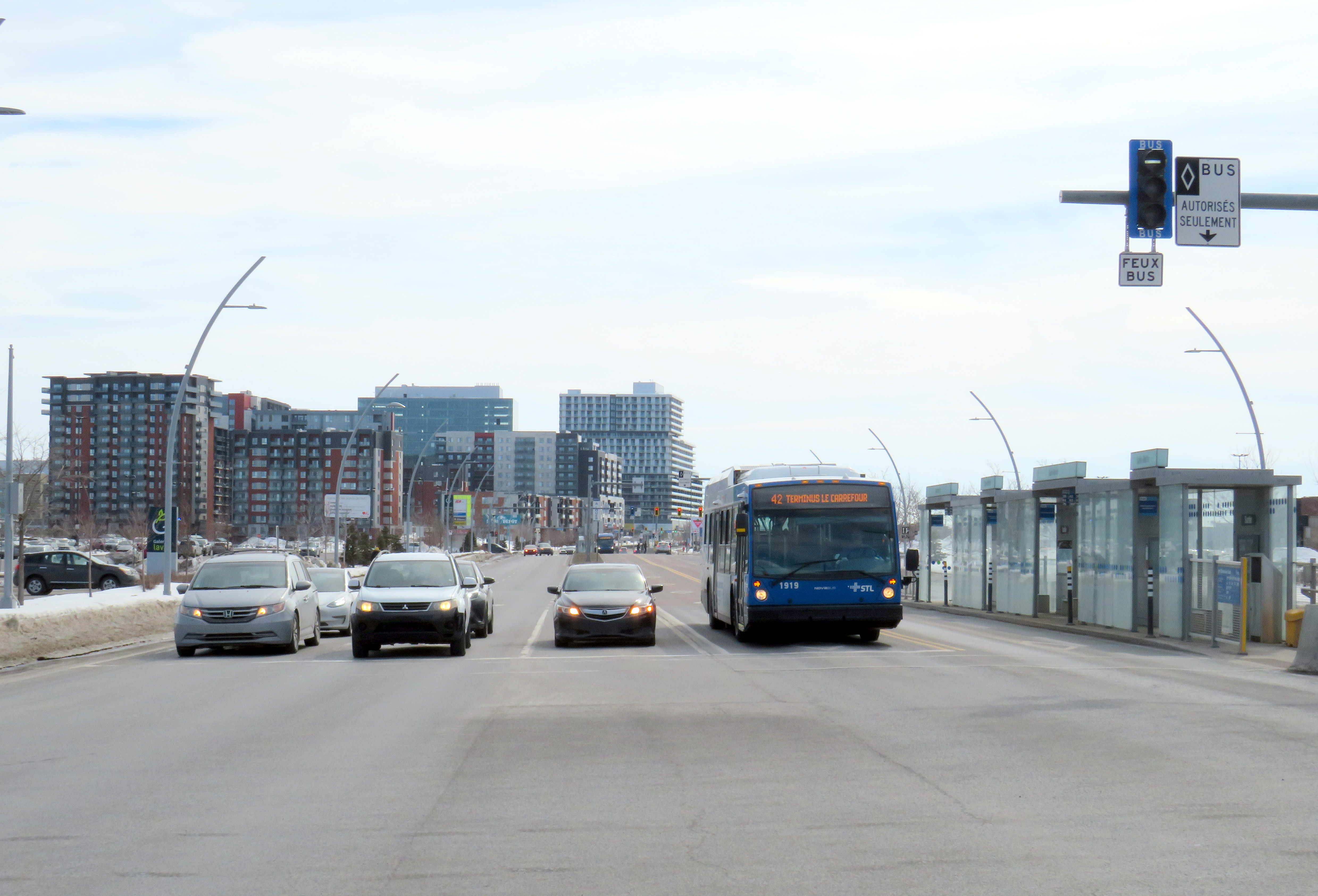
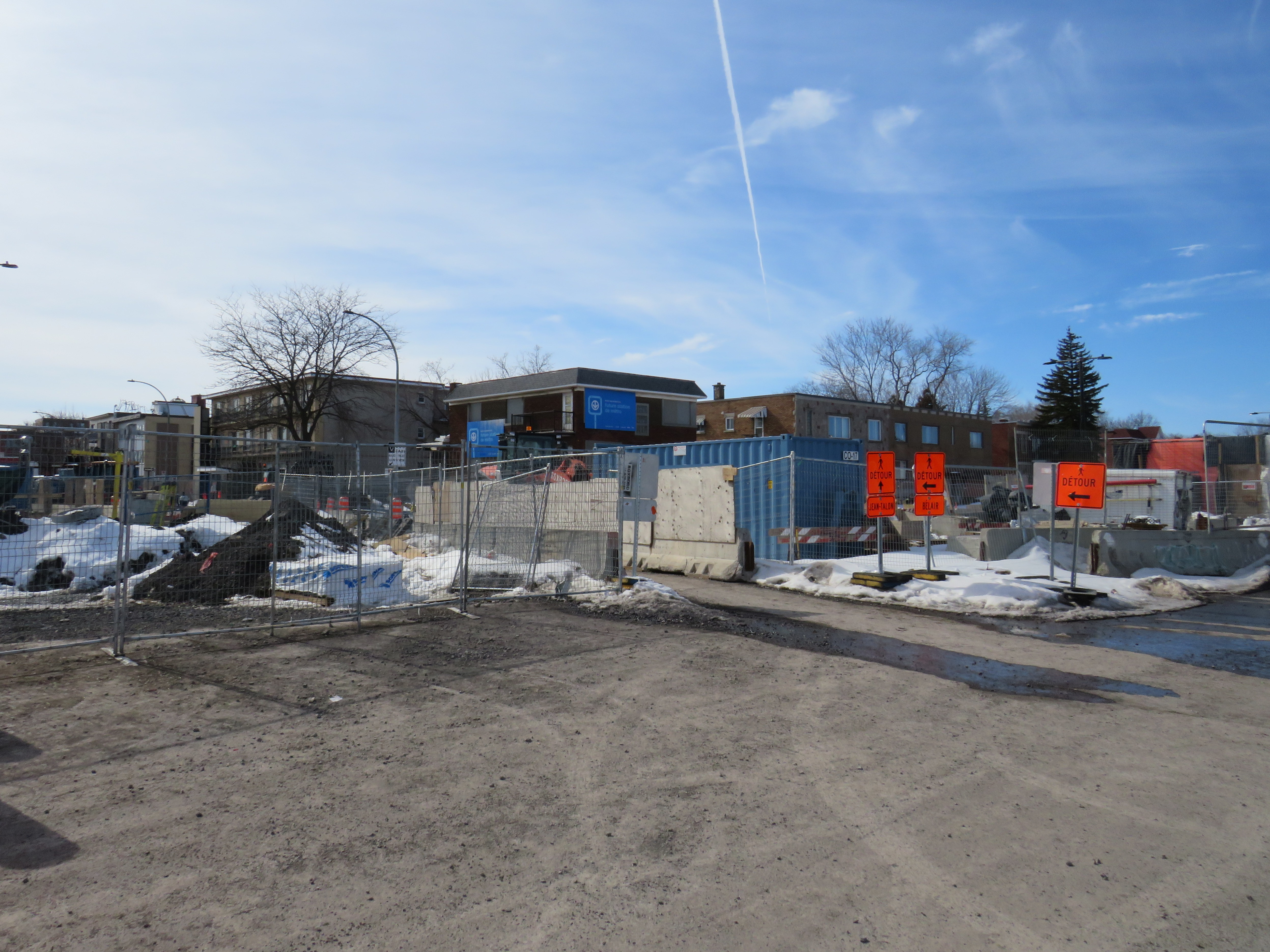
While Greater Montreal has been busy with rail transit projects, it has also opened two new busways: on Boulevard Le Corbusier in Laval, and on Boulevard Pie-IX on Montreal’s east side. The Laval busway was completed in late 2017. The SRB Pie-IX corridor was mostly completed by the end of 2022, though a section near Boulevard Jean-Talon remains under construction for the Blue Line Métro extension.
Laval’s Boulevard Le Corbusier
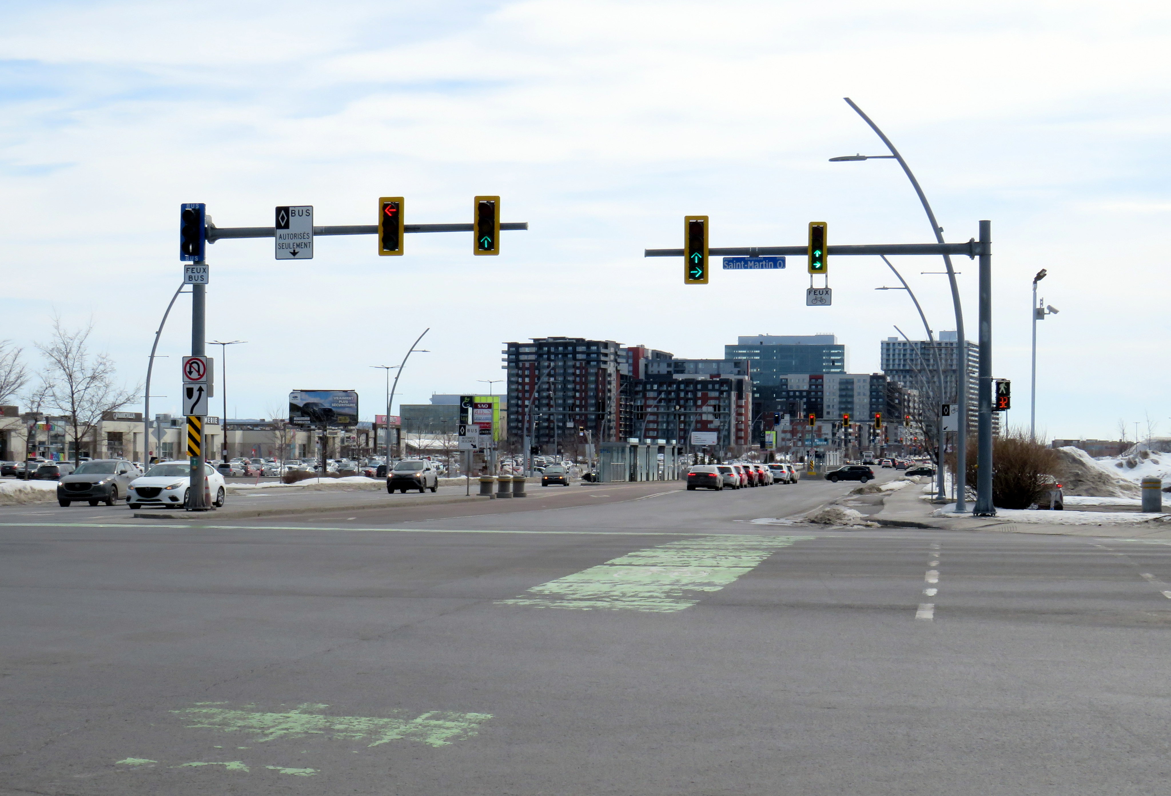
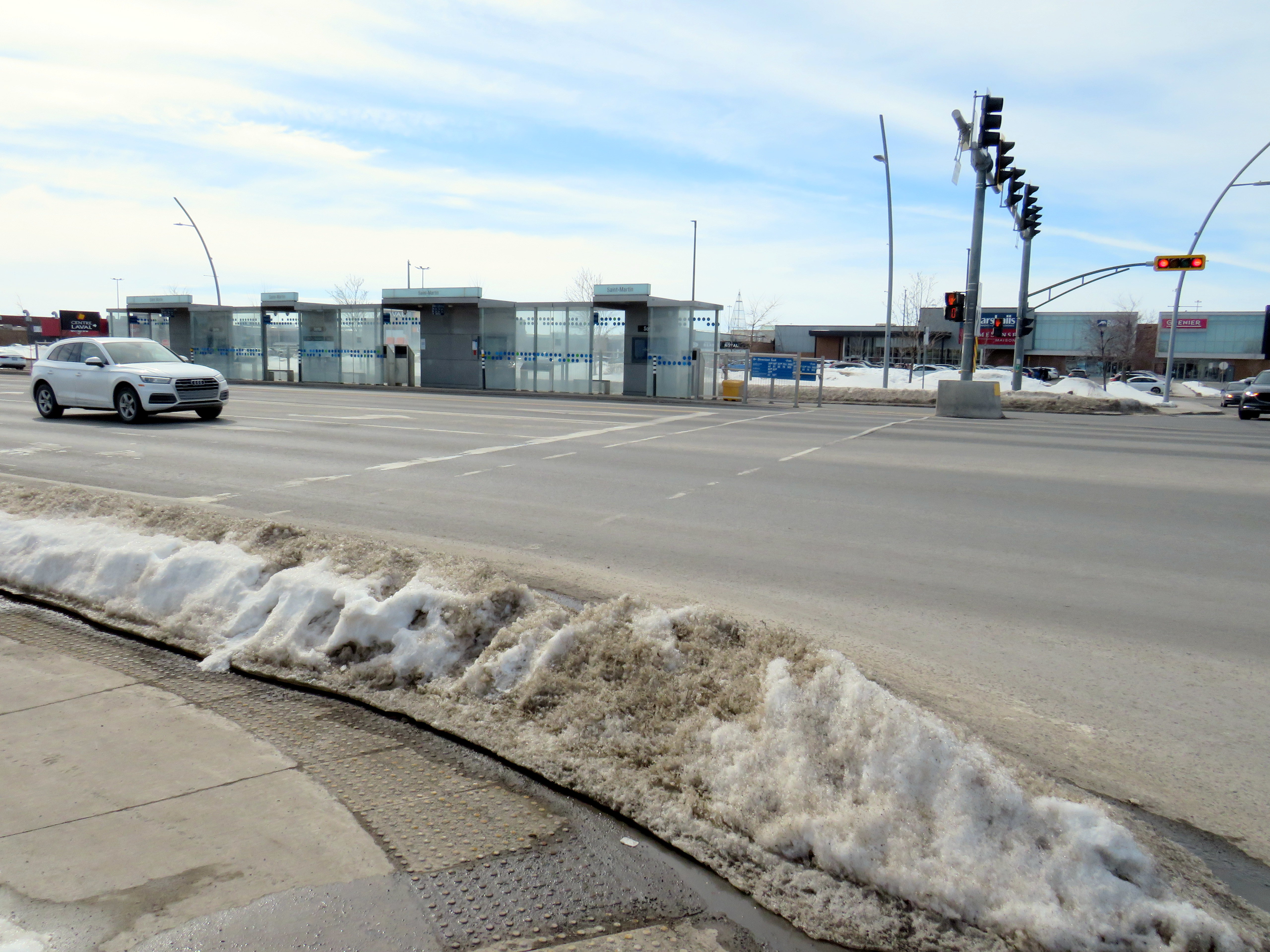
Looking south on Le Corbusier at Boul. Saint-Martin
Laval, a sprawling suburban municipality immediately north of Montreal Island, has a population of over 400,000. Though the large island has several historical town and village centres, the municipality is mostly made up of suburban subdivisions, shopping centres, low-rise apartment buildings, crisscrossed by several autoroute highways, including the A-13, A-15, A-19, A-25, and A-440. Despite the post-war sprawl and auto infrastructure, the far eastern end of the island remains largely agricultural.
After the extension of the Orange Line Métro into Laval in 2007, the city of Laval has worked towards urbanizing its geographical centre into “Centre-Ville Laval.” Laval’s new downtown core would consist of new and expanded educational institutions, new cultural and entertainment venues, office and high-tech employment, along with new higher-density, urban-scaled residential development. The new city centre would be focused on Boulevard Le Corbusier northward from Montmorency Métro Station, in an area lined with aging commercial properties.
During my March visit to Laval, some of the progress on Centre-Ville Laval was evident. A new sports and concert venue, Place Bell, opened in 2017, luring the Montreal Canadiens’ AHL affliate from St. John’s. (Place Bell should not be confused with Centre Bell, the home of the Canadiens, also located on the Orange Line). The Université de Montréal also opened a suburban campus next to the Métro station. Slowly, mid-ride condo buildings were built on the south end of Le Corbusier, within walking distance from the campuses and transit links.
New residential development on the south end of Boul. Le Corbusier, in the near distance
To support the planned growth of Laval’s city centre, a new busway was built northward, towards the massive Carrefour Laval shopping centre, a Cadillac Fairview-owned mall that dominates Montreal’s north suburbs. The busway passes between older, smaller shopping malls, such as Centre Laval and Galleries Laval, which will one day get redeveloped. Building the new busway, along with semi-protected cycling lanes, was clearly a way of indicating the municipality’s urban planning goals.
Unfortunately, the Laval busway reminded me of the things I disliked most about York Region’s Viva Rapidways. For one, the Laval busway doesn’t speed up bus service. It is only one kilometre long, and does not properly connect with either the bus terminal at Montmorency Métro or the bus terminal across the street from Carrefour Laval. Buses must re-enter mixed traffic at both ends of the route. As in Toronto and York Region, left-turning cars are prioritized at each traffic light, and there was no apparent transit priority.
The median bus stops are also difficult to get to. Despite many days since Montreal’s last significant snowfall, and bone-dry sidewalks and roadways, the curbs and crosswalks were left uncleared. This forces pedestrians to either mount the piles of old, packed, crusty snow, or divert into the roadways to cross the street. The bike lanes were merely a convenient snow storage space.
Laval should be embarrassed by its inaccessible crosswalks and bus infrastructure
For a Saturday morning, transit service on the busway was adequate, but not especially impressive. The Société de transport de Laval, the municipal transit agency, operates a free shuttle bus on weekends, holidays, and summer weekdays between Montmorency Métro and Carrefour Laval every 20 minutes. Otherwise, bus service was sporadic despite multiple routes using the busway: two or three buses would come at once, followed by a gap of 10 or 15 minutes.
Quebec’s unique traffic signals were both interesting for out-of-province visitors and frustrating for pedestrians. In Ontario and most other jurisdictions, a right green arrow indicates absolute right-of-way for right-turning motorists. In Quebec, it merely indicates that motorists have a green signal to turn right, regardless of conflicting movements. Outside of Montreal, motorists are permitted to turn right on a red light, unless signed otherwise. This is not great signalization, especially on high-speed suburban roadways.
Right-turning motorists have the green arrow to turn right, conflicting with pedestrians (which have the walk signal) and cyclists
However, bus signals are unmistakable from general traffic signals, with white bar aspects (and a white triangle instead of an amber light). That’s one thing that is done better than here in Ontario.
Montreal’s SRB Pie-IX
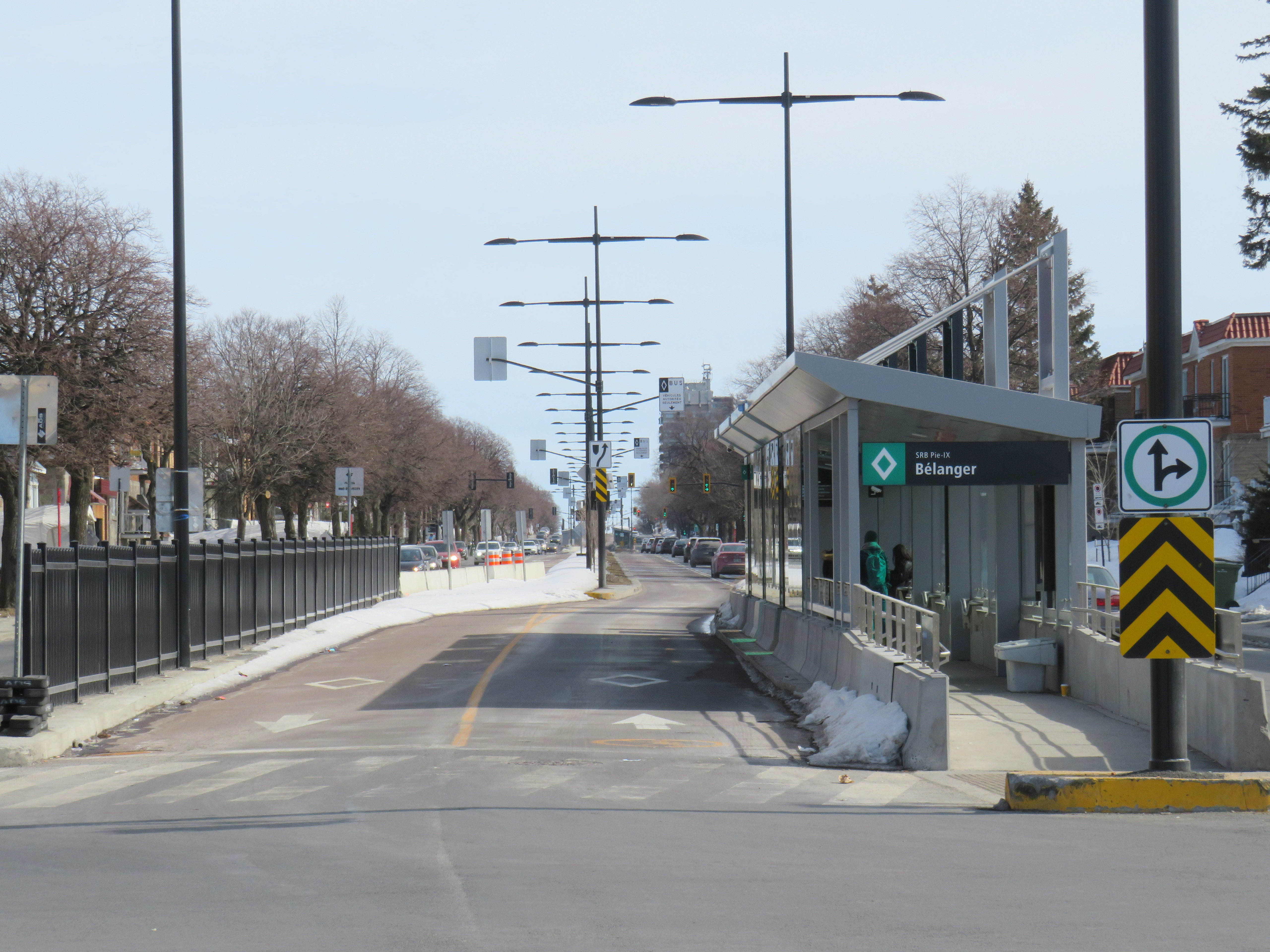
Looking south on Boul. Pie-IX from Rue Bélanger
The SRB (BRT) corridor on Montreal’s Boulevard Pie-IX, which I visited later the same day, was a welcome contrast to Laval’s implementation. Boulevard Pie-IX (named for Pope Pius IX, the founder of the dogma of papal infallibility), is a wide north-south boulevard on Montreal’s east side, passing through Hochalaga, past Olympic Stadium and the Botanical Gardens, all the way into Laval. It’s a busy bus corridor, feeding into the Métro Green Line as well as the future extension of the Blue Line to Anjou.
The intersection of Pie-IX and Jean-Talon, where a new Métro station is under construction
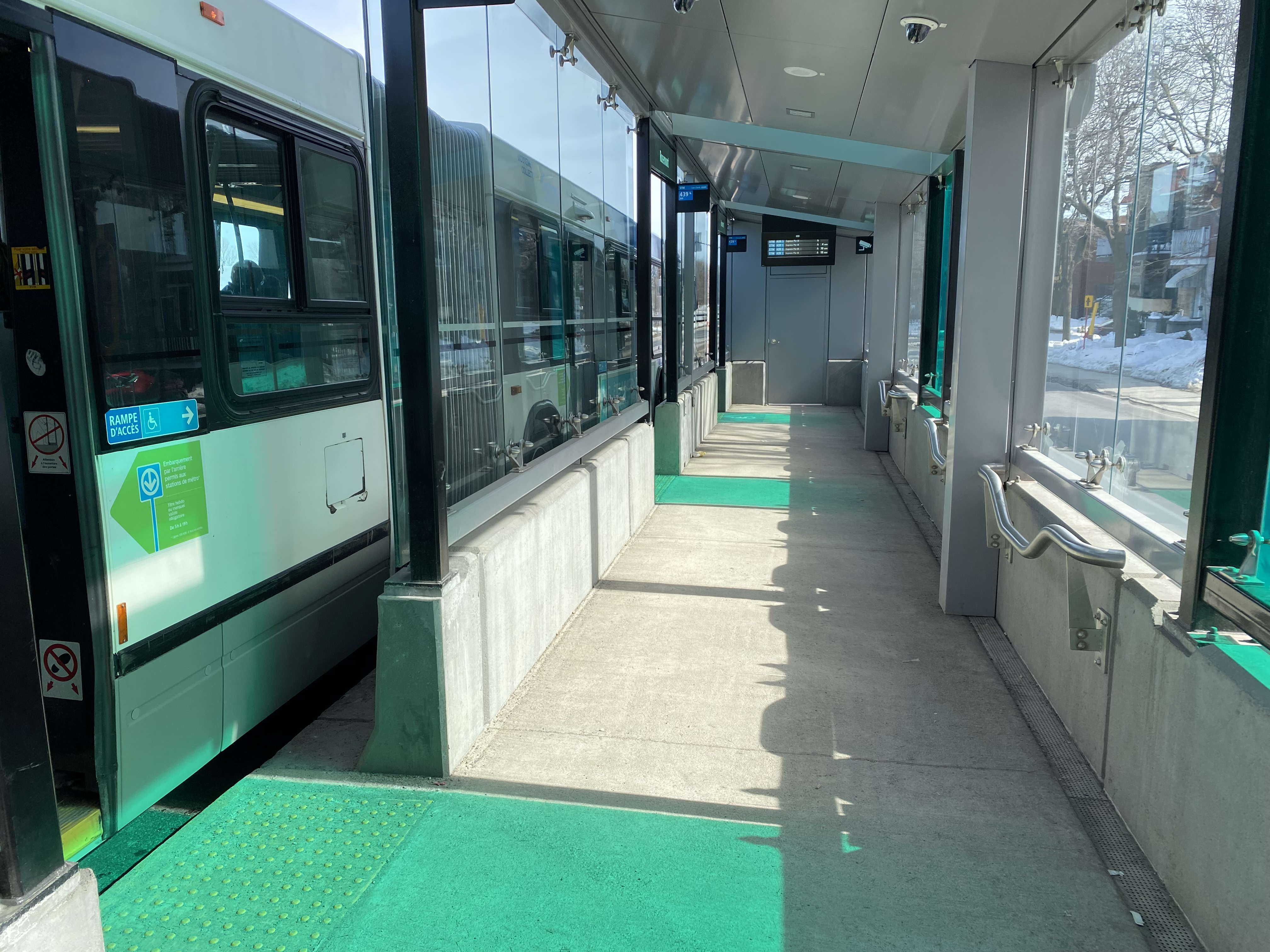
The 439 SRB route parallels the local 139 Pie-IX bus, and like other median busways, passengers board and exit at stops at the far side of the intersection. Though there is no fare pre-payment, passengers are permitted to board at rear doors with a valid Opus card or ticket. Shelters are simple, but the stained green glass lines up nicely with the gaps where the bus doors open.
Inside a SRB shelter
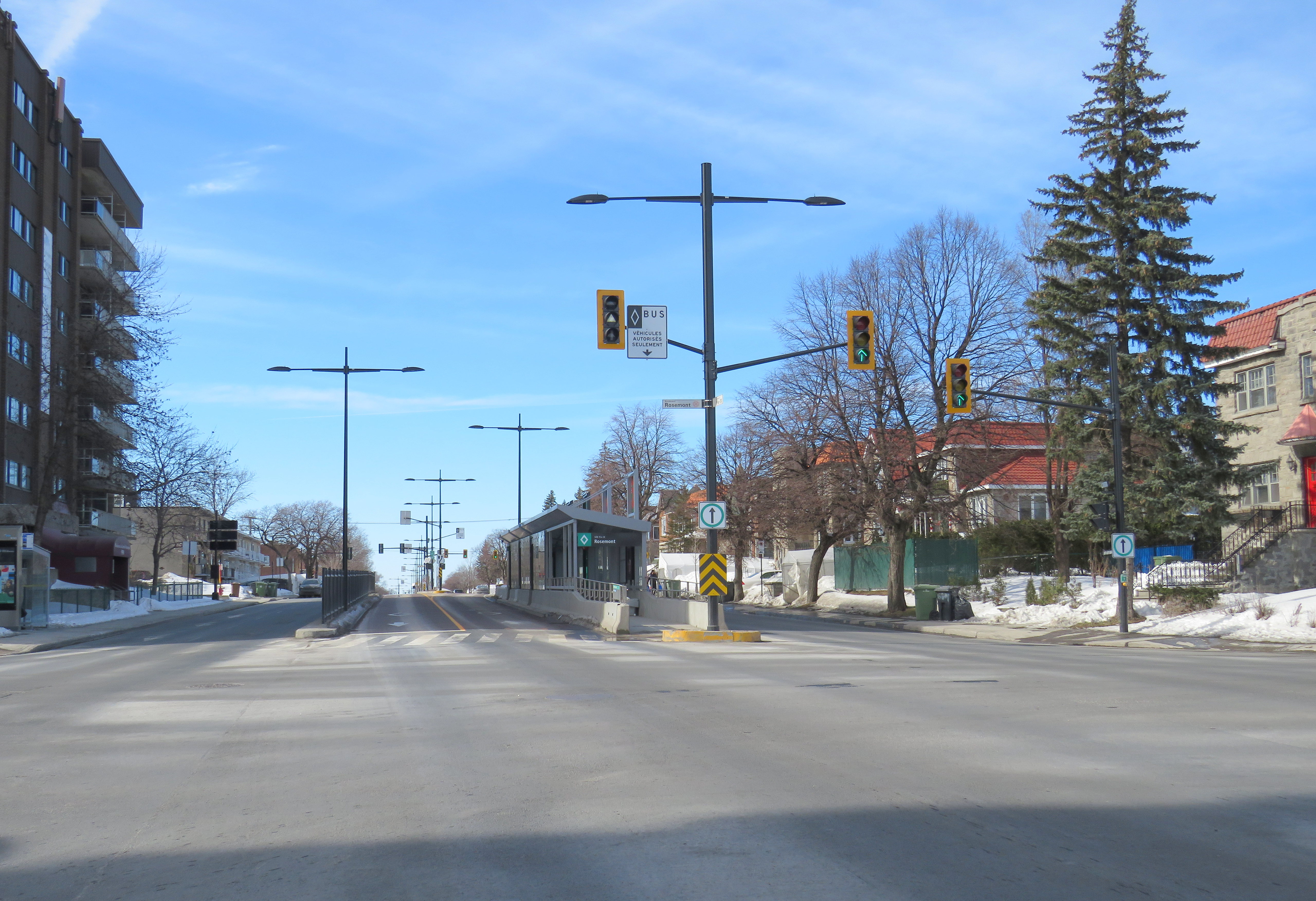
Unlike median busways elsewhere in Ontario or Quebec, buses are not slowed down by left-turning motorists as left turns are prohibited along the entire SRB corridor. This simplifies operations, allows for easier transit priority, and reduces the space required at intersections for dedicated left turn lanes. Unlike Laval, the crosswalks in Montreal were cleared and easy to traverse in winter.
Left turns are banned along the entire SRB corridor. Note the triangle light on the bus signal.
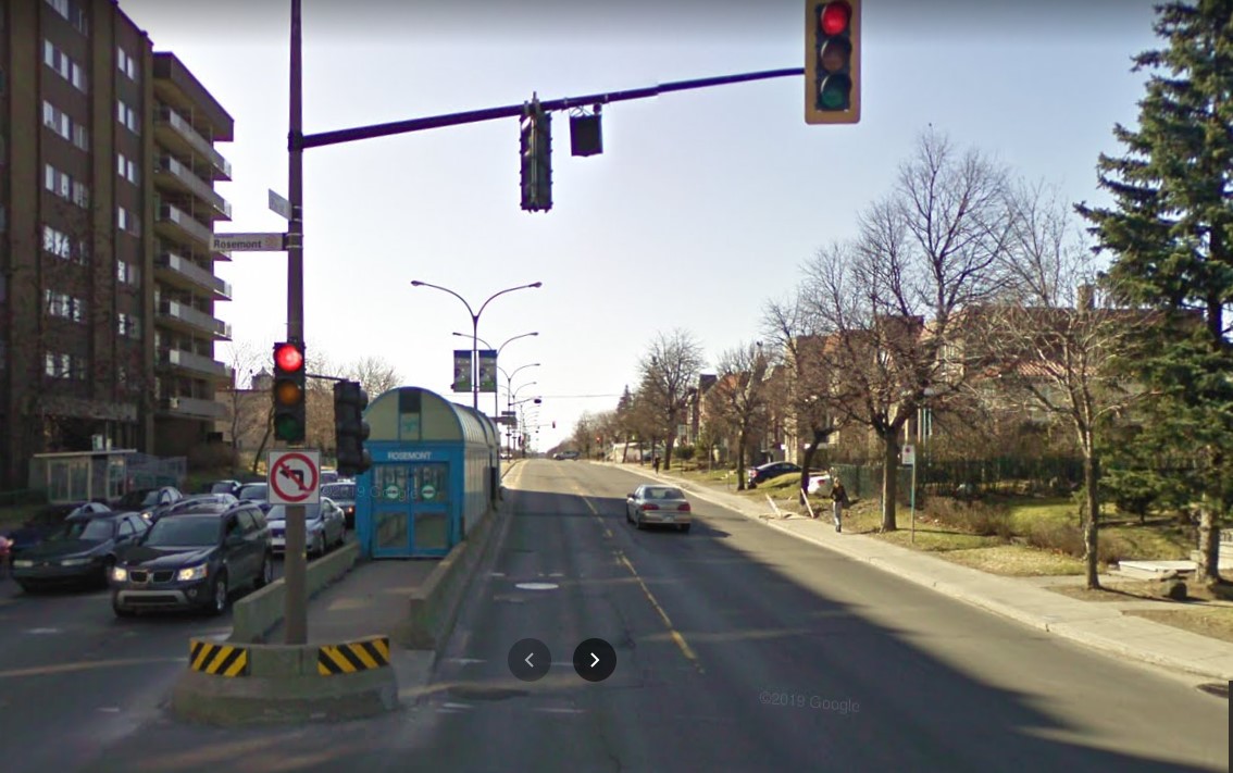
The current bus rapid transit alignment replaces an older, more dangerous set up where there was a central median where the inner lane was dedicated to buses in the opposite peak (contraflow) direction during weekday rush hours. Buses assigned to Pie-IX were equipped with special flashing arrows to warn oncoming motorists, along with overhead lights indicating the lane restriction. After several serious collisions, the arrangement was abandoned.
2009 Google Streetview image of the old Pie-IX express bus arrangement, where buses in the AM peak used the leftmost northbound lane to travel south, stopping at the median shelter. In the PM peak, northbound buses used the rightmost southbound lane.
Once again, Montreal shows how buses can be sped up without compromising safety or road space. Restricting left turns along the entire corridor was the right choice, and a solution that should be considered along some of Toronto’s busiest bus corridors as well.
Finally, rapid transit corridors on arterial roads are reliant on walk-up traffic, and should therefore be as easy and safe as possible to walk up to the transit service. This means effective and quick snow removal at crosswalks, pedestrian priority (there should be no beg buttons to push to access BRT/LRT stops), and proper pedestrian infrastructure and a walkable realm. The Viva Rapidways and the Laval Boul. Le Corbusier fail this basic criteria, while Montreal does a better job.
As Greater Toronto area plans more arterial LRT and BRT corridors, such as on Dundas Street in Mississauga/Oakville, and on Queen Street in Brampton, it would be wise to put transit and active transportation first, even if it means sacrificing a few left turn lanes.
In January 2023, while visiting the site of the now-demolished Sarnia Eaton Centre, I took advantage of two new rural transit services serving Southwestern Ontario: Strathroy-Caradoc Transit and Huron Shores Area Transit. While both services connect London and Sarnia, they operate as separate services with different fares; they also have different terminals.
Strathroy-Caradoc Inter-Community Transit bus at Lambton Mall in Sarnia
Strathroy-Caradoc Transit offers the most direct service between London and Sarnia, with stops at London International Airport, Downtown London (on York Street near the VIA Station), Komoka, Mount Brydges, Strathroy, Lambton Mall, and Downtown Sarnia.
The regular cash fare between London and Sarnia is $20, though from London or Sarnia to Strathroy, the fare is $10. On my westbound trip on Sunday, January 29, the schedule allowed for a quick washroom and coffee break in Downtown Strathroy, a necessity given the long ride on a small minibus.
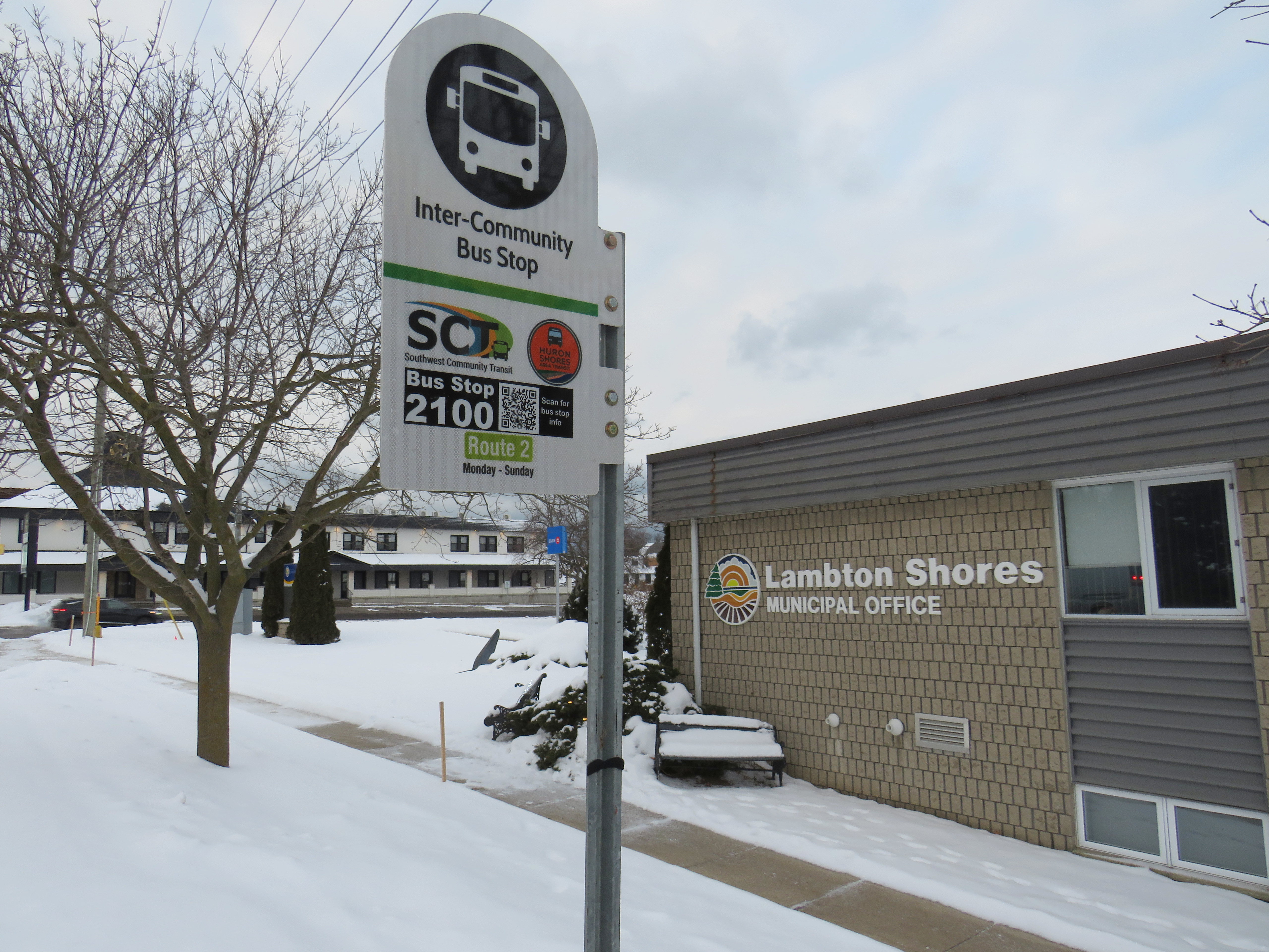
Returning the next day from Sarnia, I opted to ride Huron Shores Area Transit (HSAT) back to London. HSAT, which is also contracted to Voyago, connects several communities in Lambton, Huron, and Middlesex Counties. All four HSAT routes converge in the summer resort town of Grand Bend. Two routes operate seven days a week (Route 1, connecting Sarnia, Forest, Thedford, and Kettle Point & Stoney Point First Nation, and Route 2, serving Exeter, Lucan, Centralia, and London). There are two additional routes operating two days a week from Grand Bend to Goderich and to Parkhill and Strathroy.
Unlike Strathroy-Caradoc, HSAT operates on a flat $5 cash fare. Even though I was traveling the long way between Sarnia and London, with an hour-long layover in Grand Bend, I was offered a slip of paper marked by the driver that allowed me to board the second bus without a second fare. Huron Shores buses have bike racks, though the operator recommends calling ahead to ensure their availability.
While Strathroy-Caradoc Transit serves downtown London and Sarnia, HSAT’s buses go only as far as the first major destination in both cities. The Sarnia stops for Route 1 are at Lambton College and nearby Lambton Mall, while the London stops on Route 2 are on London’s north end, near Masonville Place and at the University Hospital on the Western University campus. Getting downtown requires a transfer to Sarnia or London Transit.
Huron Shores Area Transit bus at London’s University Hospital. Note the bike rack.
Though VIA Rail still operates one daily train between Toronto, London, and Sarnia, it is not on a convenient schedule for most passengers (it leaves Sarnia early in the morning and arrives late in the evening), so the new bus services fill a key role in providing mobility options. Though it is more expensive, the Strathroy-Caradoc route is the direct and the fastest connection. But Huron Shores trip is the more scenic and cheaper ride.
I updated my Ontario intercity transportation map for April 2023 to include the major GO Transit service changes, the gradual resumption of some Ottawa commuter bus routes, the start of Travelways bus service between Detroit, London, and Toronto, and minor route and service changes elsewhere in the province.
The hour-long layover in Grand Bend gave me a chance to wander the town. On the main street, almost every business was closed for the season. There was very little traffic on Main Street, so it had a bit of a ghost town feel. On Highway 21 and to the east, however, typical chain stores like Tim Hortons, Sobey’s, and Shoppers Drug Mart serve the year-round population.
Grand Bend’s famous beach — in JanuaryHello Sunshine
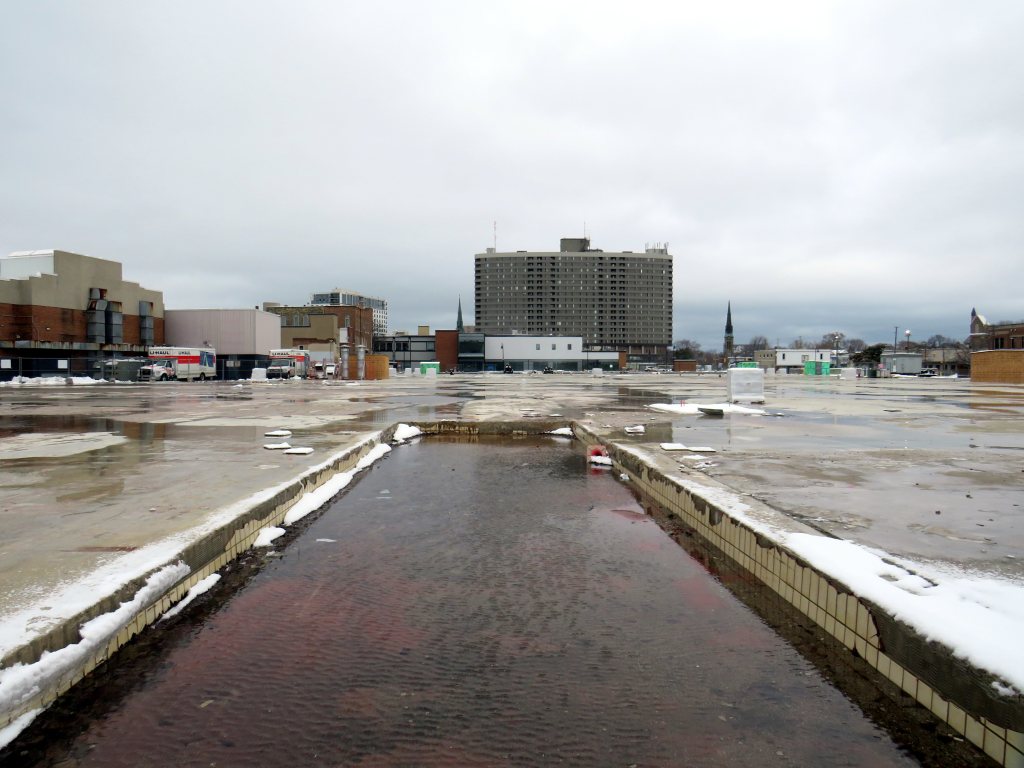
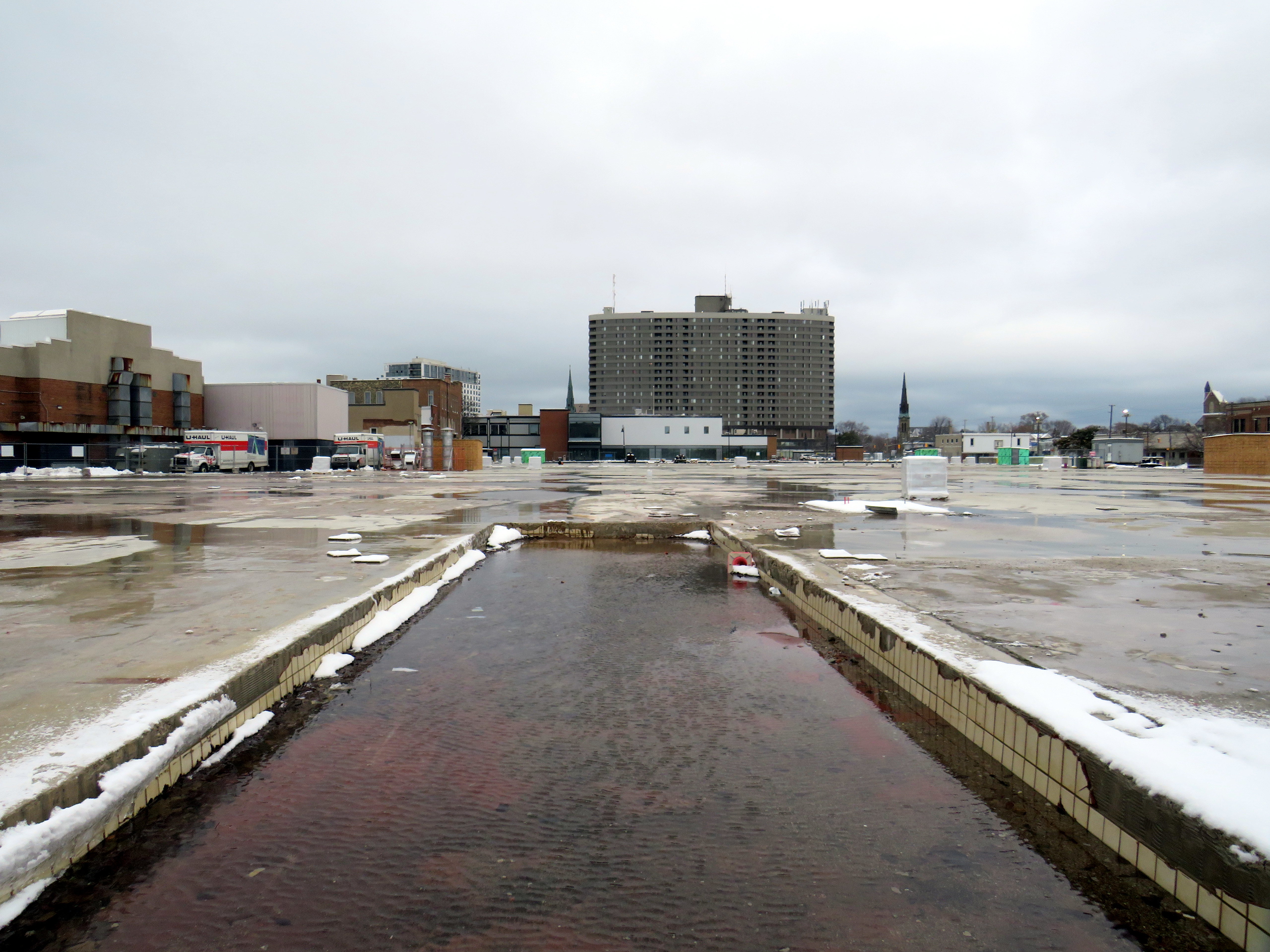
Late last year, I wrote about the closure of the Hamilton City Centre mall, the last of Ontario’s downtown Eaton Centres to open. But Hamilton’s failed shopping centre wasn’t the only old downtown mall to close in recent years: Sarnia’s Bayside Centre, opened in 1982 as the Sarnia Eaton Centre, was recently demolished, with a seniors’ residence and long-term care home set to take its place.
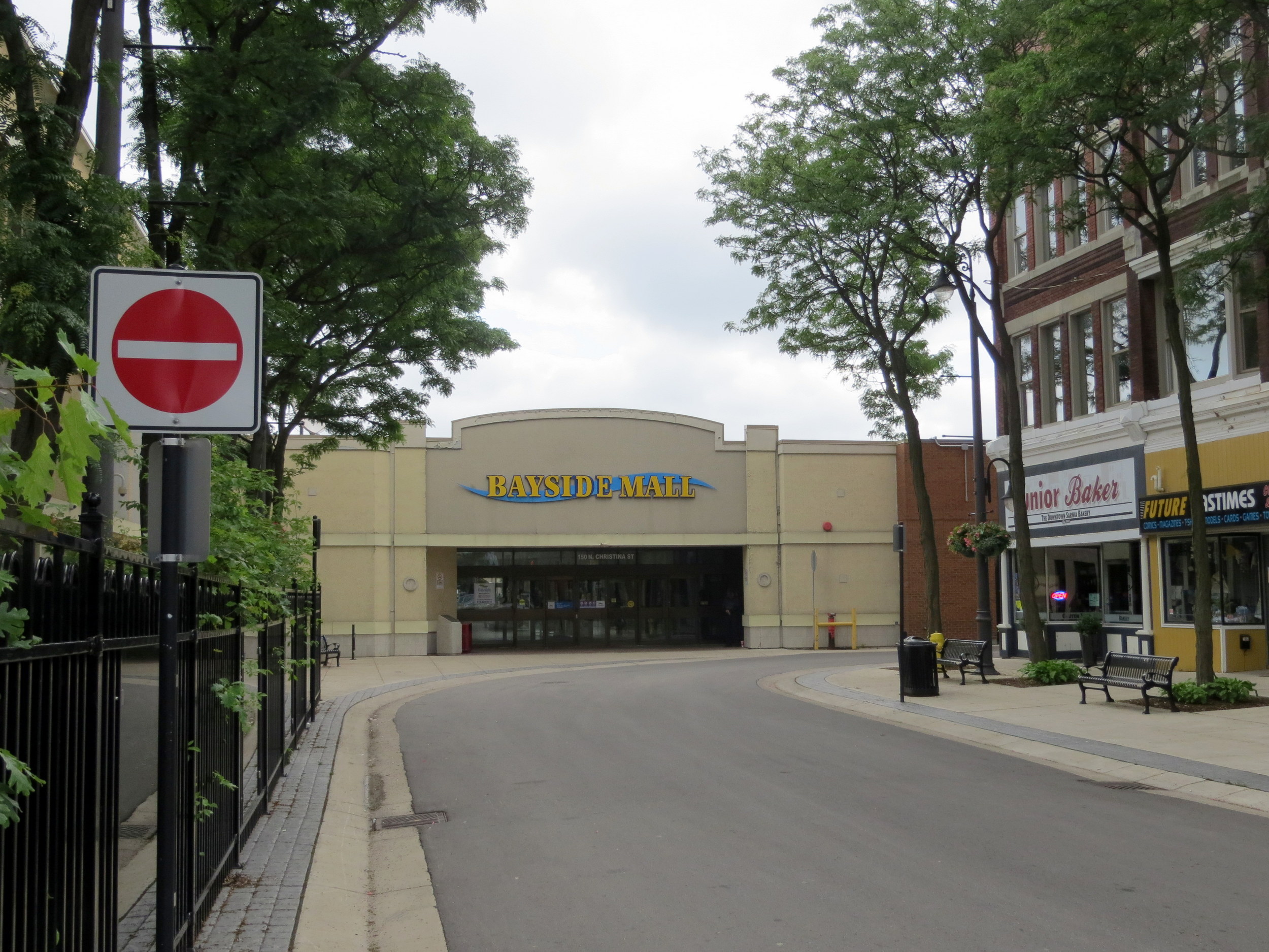
Bayside Mall in 2013
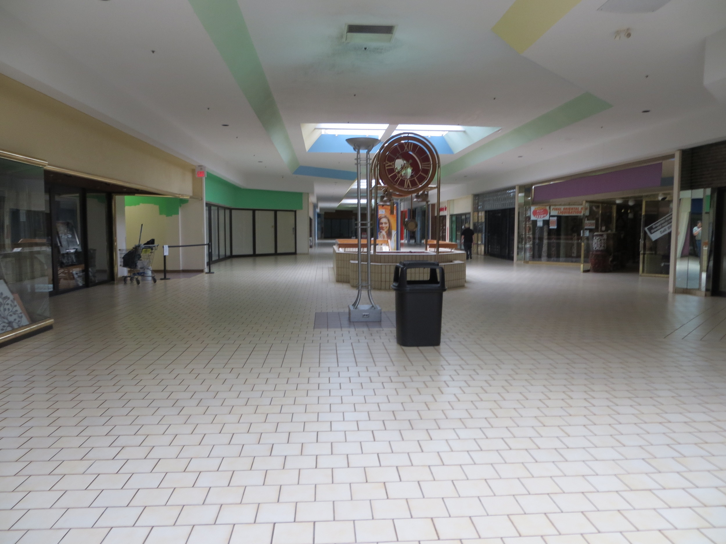
I previously visited Sarnia’s Bayside Mall in 2013, when the mall was already mostly dead. Community uses, such as a local museum, a Canadian Blood Services clinic, a seniors’ drop-in centre, and a March of Dimes office predominated, with only Hong Kong Express and Subway left in the food court, and a few other shops — a rug store, an optician, a beauty salon, and a pharmacy — scattered amongst the vacant storefronts. The old Eaton’s department store was already converted into offices for Lambton County’s social services department.
The old fountain at the main entrance to Bayside Mall in 2013.
As I discussed previously on this website, there was a downtown redevelopment boom across Ontario in the 1970s and 1980s, with municipalities and the province eager to support the construction of new shopping centres to help them compete with suburban malls.
The Sarnia Eaton Centre was the first of several malls funded by the Ontario Downtown Redevelopment Program, though previous downtown shopping centres, such as Hamilton’s Jackson Square and the Sudbury City Centre, were built with municipal support.
The case for Sarnia Eaton Centre was always weak, but it was the result of inter-municipal rivalry as much as it was an attempt to revitalize Downtown Sarnia. In the 1970s, Lambton Mall opened in the city’s outskirts, near the intersection of Highways 40 and 402. But Lambton Mall was built outside the city limits, in suburban Sarnia Township. Lambton Mall’s anchors included Sears, Canadian Tire, and Toys R Us.
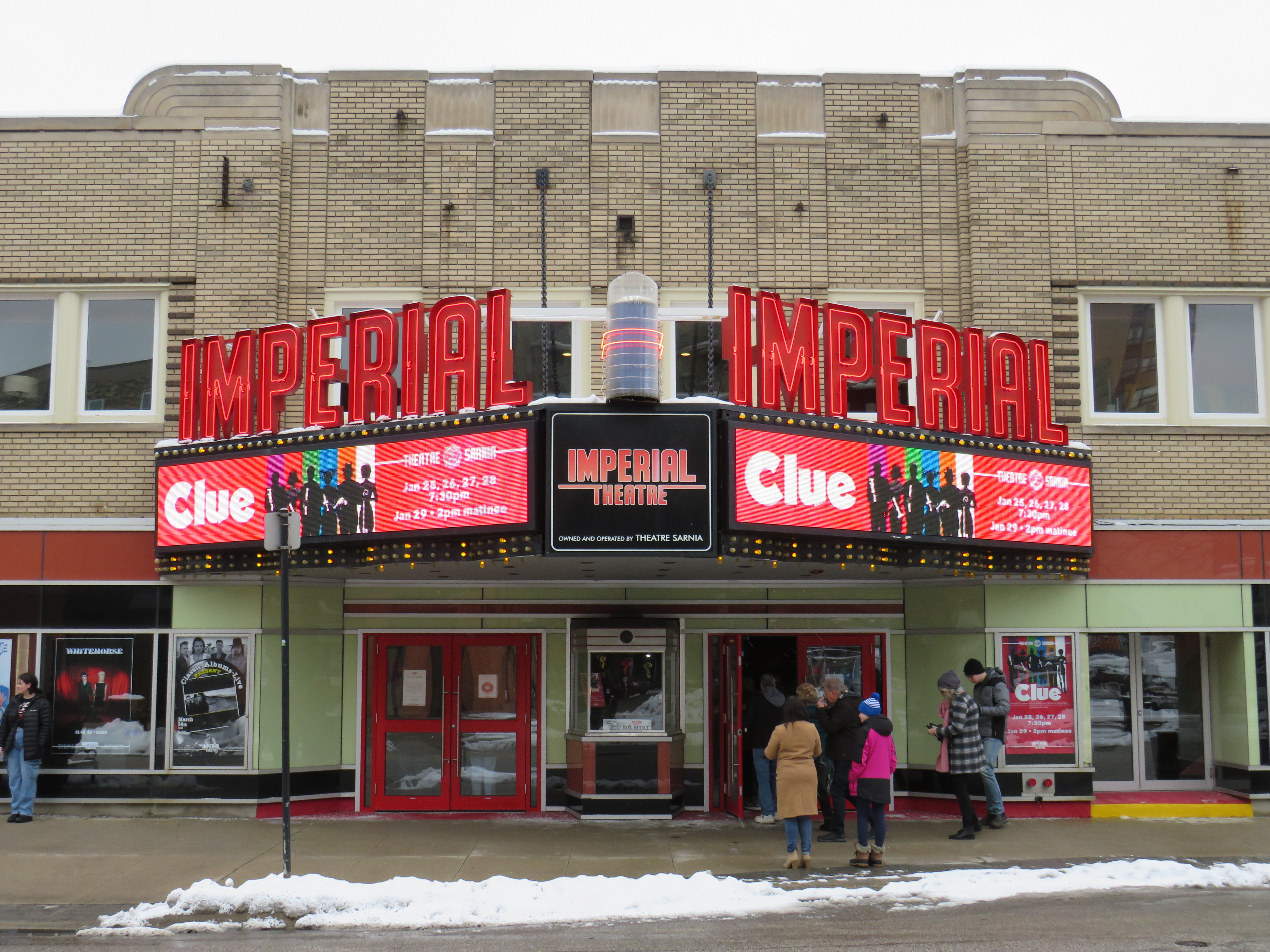
While Sarnia Township’s population was growing due to residential, industrial, and institutional growth (Lambton College’s main campus was also established in the township, near Lambton Mall), the City of Sarnia’s population declined. Along with the new Eaton Centre, the city also encouraged new highrise residential development in the downtown core, and two new office buildings were also constructed. The city – with support from Imperial Oil, a major employer – renovated the old movie theatre, converting it to a playhouse for local productions and touring shows.
The Imperial Theatre remains a popular attraction
When it opened in 1982, Sarnia Eaton Centre was the centrepiece of Sarnia’s downtown comeback. It filled in nearly four blocks of Downtown Sarnia, with Lochiel Street closed between Christina and Vidal Streets, and Victoria Street closed north of Cromwell.
The mall was anchored, of course, by Eaton’s, a smaller, two-storey store with 91,470 sq. ft. of floor space (just under 8500 square metres), and an A&P supermarket on the southern end. Sarnia Eaton Centre’s 1993 Canadian Directory of Shopping Centres, showed that the mall still had a healthy assortment of national retailers, along with some local businesses. But many retailers refused to renew their store leases, and when Eaton’s entered bankruptcy for the first time in 1997, the Sarnia store was among the first to close.
The City of Sarnia merged with Sarnia Township in 1991, while the area surrounding Lambton Mall continued to grow as the region’s commercial centre. Big-box stores such as Walmart and Home Depot clustered around the older mall, and even with Sears Canada’s closure, Lambton Mall continued to do well, with Marshalls/Home Sense taking over the old Sears store.
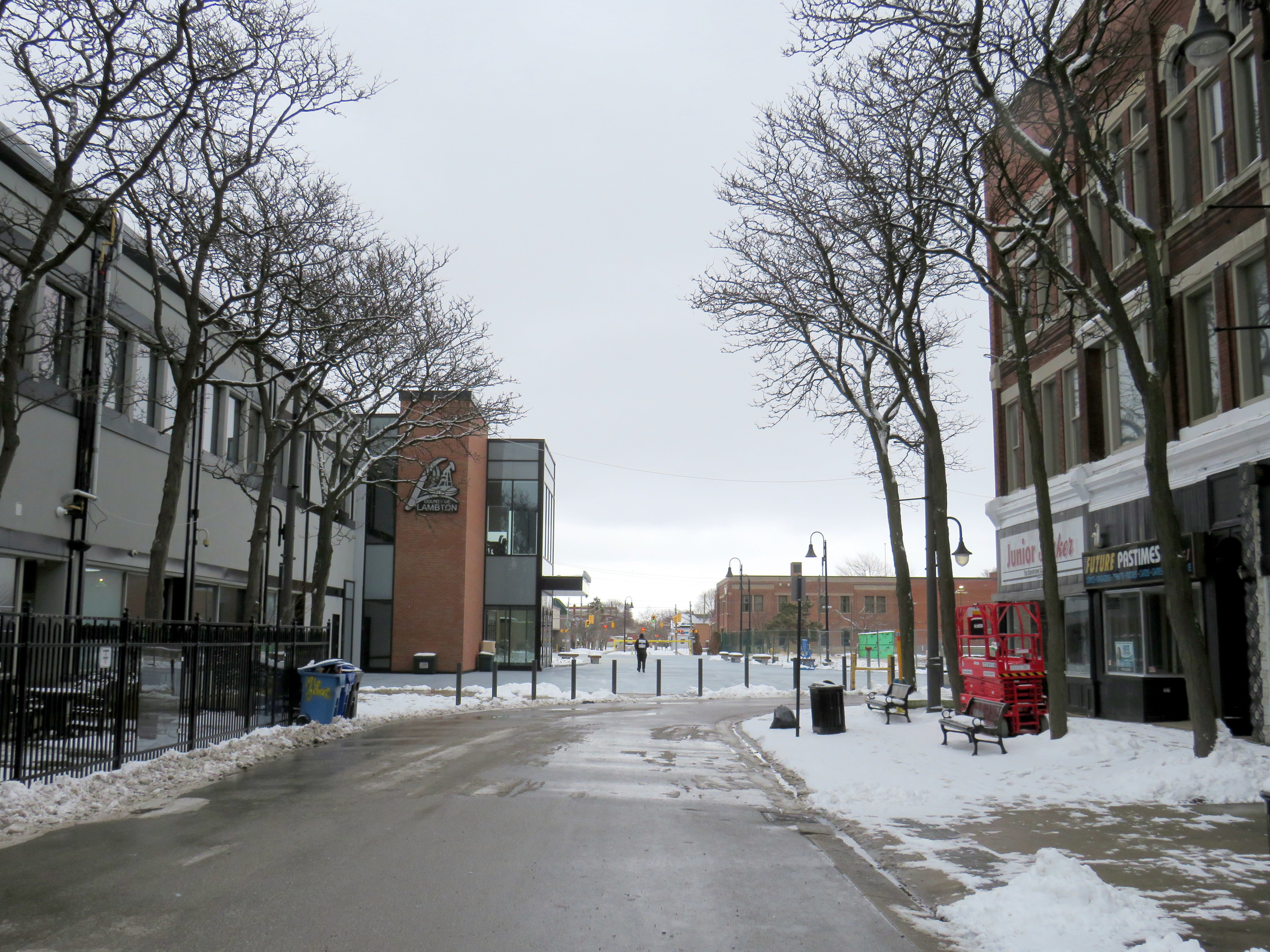
20132023
The Bayside Mall property was purchased by Seasons Retirement Communities in 2017, and most of the mall was demolished in 2021-2022. Lambton County, which operated its social services offices in the former Eaton store, expanded its footprint, with a new municipal courthouse located next to the old Eaton’s store, which was renovated.
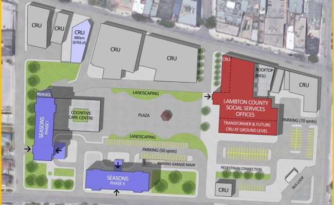
Lochiel Street has been partially restored as a pedestrian walkway across the site, while the southern half of the old mall will be redeveloped for mid-rise seniors’ homes, with a central plaza.
Map showing the redevelopment of Bayside Mall, with the Lambton County building, in red, already complete in early 2023. The top of the map faces west.
Meanwhile, Downtown Sarnia will continue to hold its own. It has a few nice restaurants, cafes and pubs, and the highrise development of the 1970s and 1980s ensures that there’s a local population that will frequent the businesses there. The addition of seniors housing won’t hurt either.
Below is the list of tenants at Sarnia Eaton Centre in 1992, obtained from the 1993 Canadian Directory of Shopping Centres, published by Maclean-Hunter. In 1992, the collection of retailers was still quite strong, largely driven by Cadillac Fairview’s leasing team.
Anchors
A&P (26,512 sq ft), Eaton’s (91,470 sq. ft)
Fashions and footwear Children’s wear: Just Kids Unisex/family wear: Le Chateau, D’Gala, Pantorama, Stitches, Thrifty’s Ladies’ wear: Fairweather, Irene Hill, Just Petites Lady Foot Locker, Lindor, Reitmans, Smart Set, Suzy Shier Menswear: Tip Top Footwear/leather goods: Agnew, Baronessa, Bata, Belinda & Brother, Joggers, Kinney, Mr. Minit Shore Repair Jewellery/accessories: Ardene, People’s
Other retailers Books/stationery: Carlton Cards, Garfield, WH Smith Health and beauty: Caryl Baker Visage, Shoppers Drug Mart Department store/mass merchandiser: Marks & Spencer, A Buck Or Two Electronics: Radio Shack Entertainment: Fun & Games Furniture & furnishings: Brass Collections Gifts: Things Engraved Hardware/paint & paper: St. Clair Paint and Wallpaper Housewares: The Royal Douton Store, Stokes Music/ records & tapes: Discus, Music World Pets: Tropicarium Pet Centre Photo/camera: Black’s, Japan Camera Restaurants & fast food: Elephant & Castle, Global Donuts, Hamby’s, Hong Kong Express, Kernels, Mykie’s, Viva Pasta Specialty food & drink: Laura Secord, mmmarvellous mmmuffins, Second Cup
Services Banks/financial: Canada Trust, TD Bank Hairstyling/esthetics: Regis Hairstylists Medical/dental: Tridont Dental Travel: Marlin Travel Misc: Infoplace
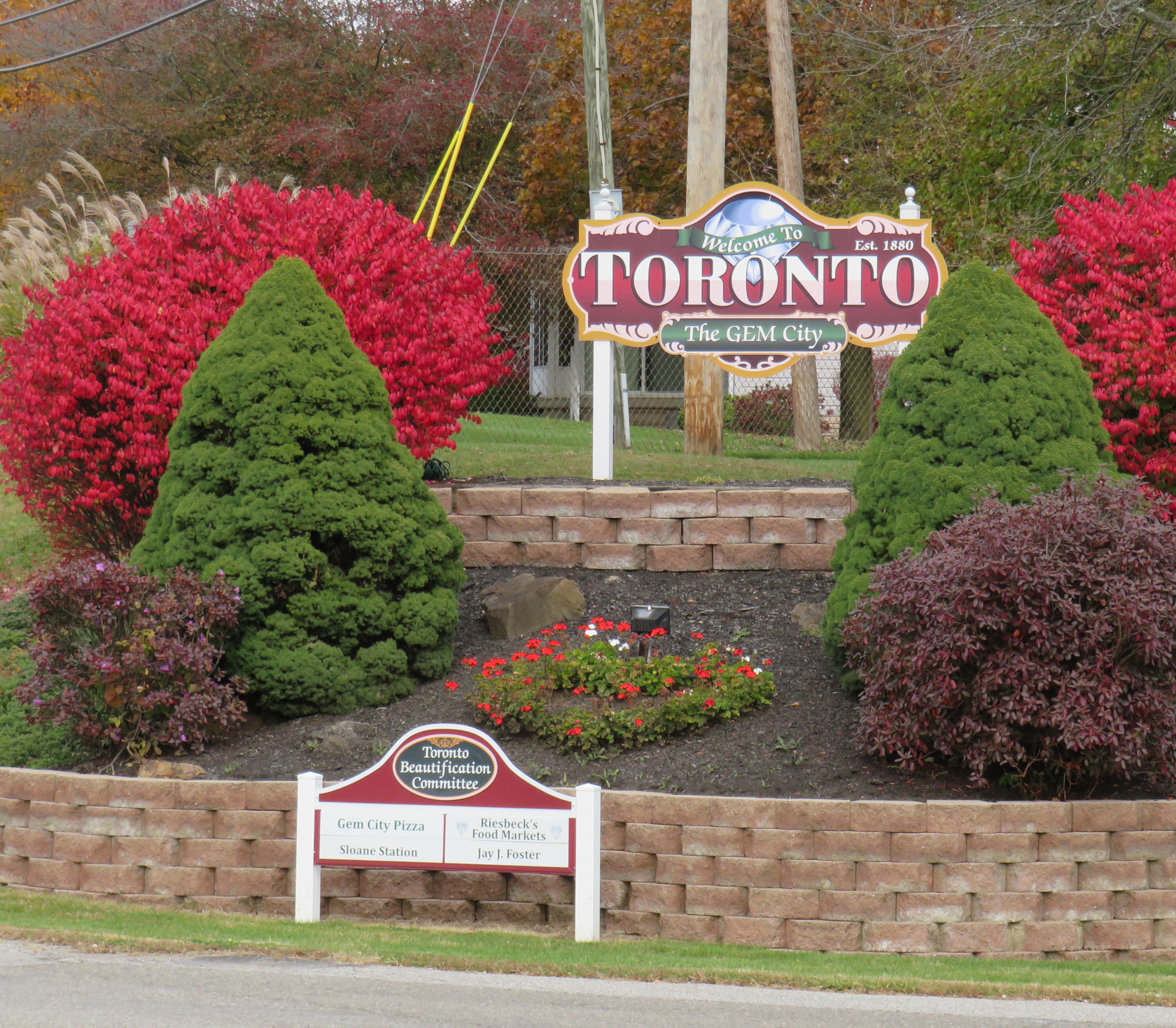
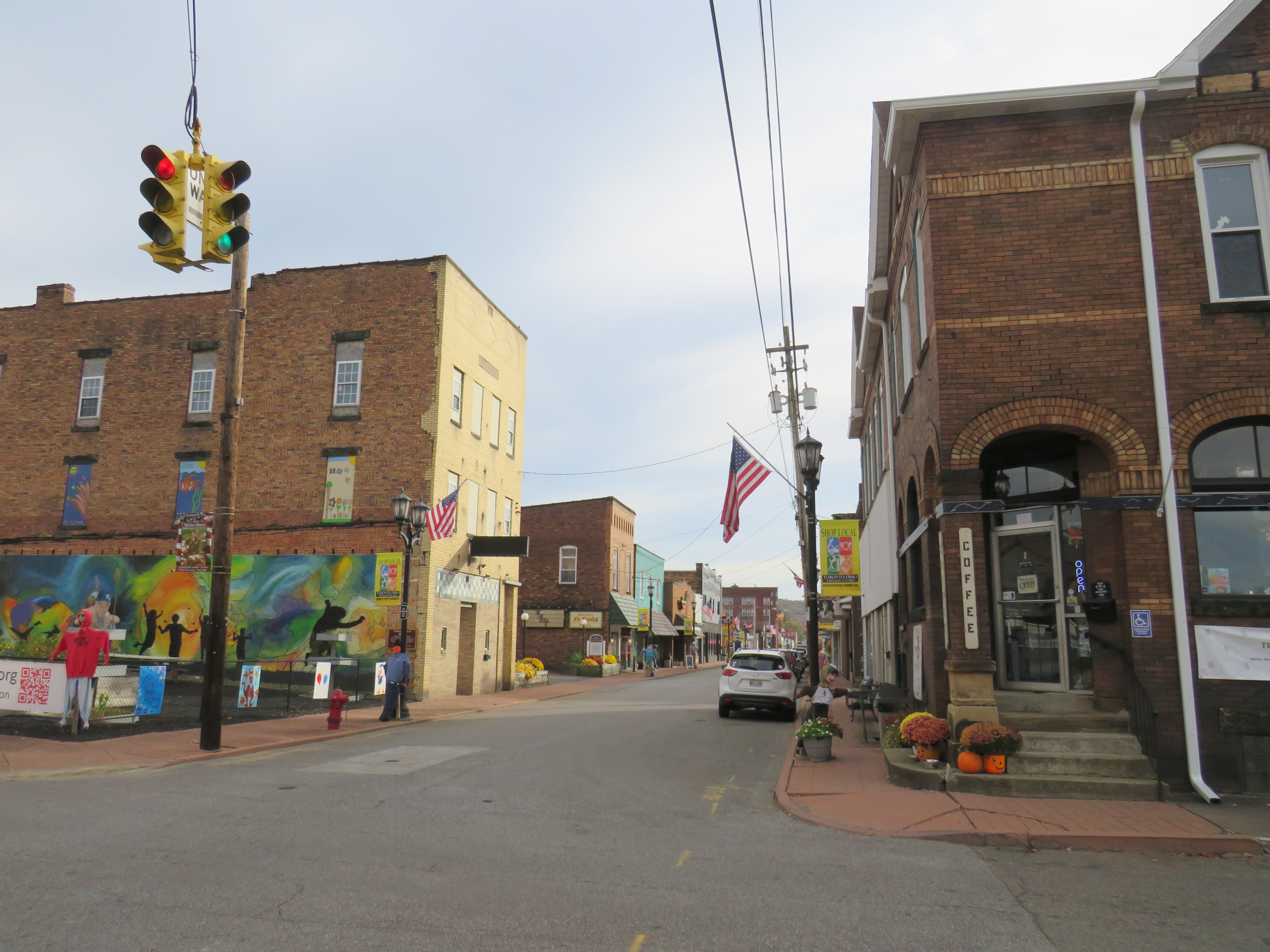
The small Ohio community was originally named Sloan’s Station, but when it was incorporated as a city, they chose “Toronto” because local businessman W.F. Dunspaugh, a Toronto (Ontario) native, thought his hometown was “a place worth emulating.” Toronto, Ohio is the only other city named Toronto, but other Torontos exist, including the town of Toronto, South Dakota (population 212) and the town of Toronto, New South Wales, Australia (population 5,161).
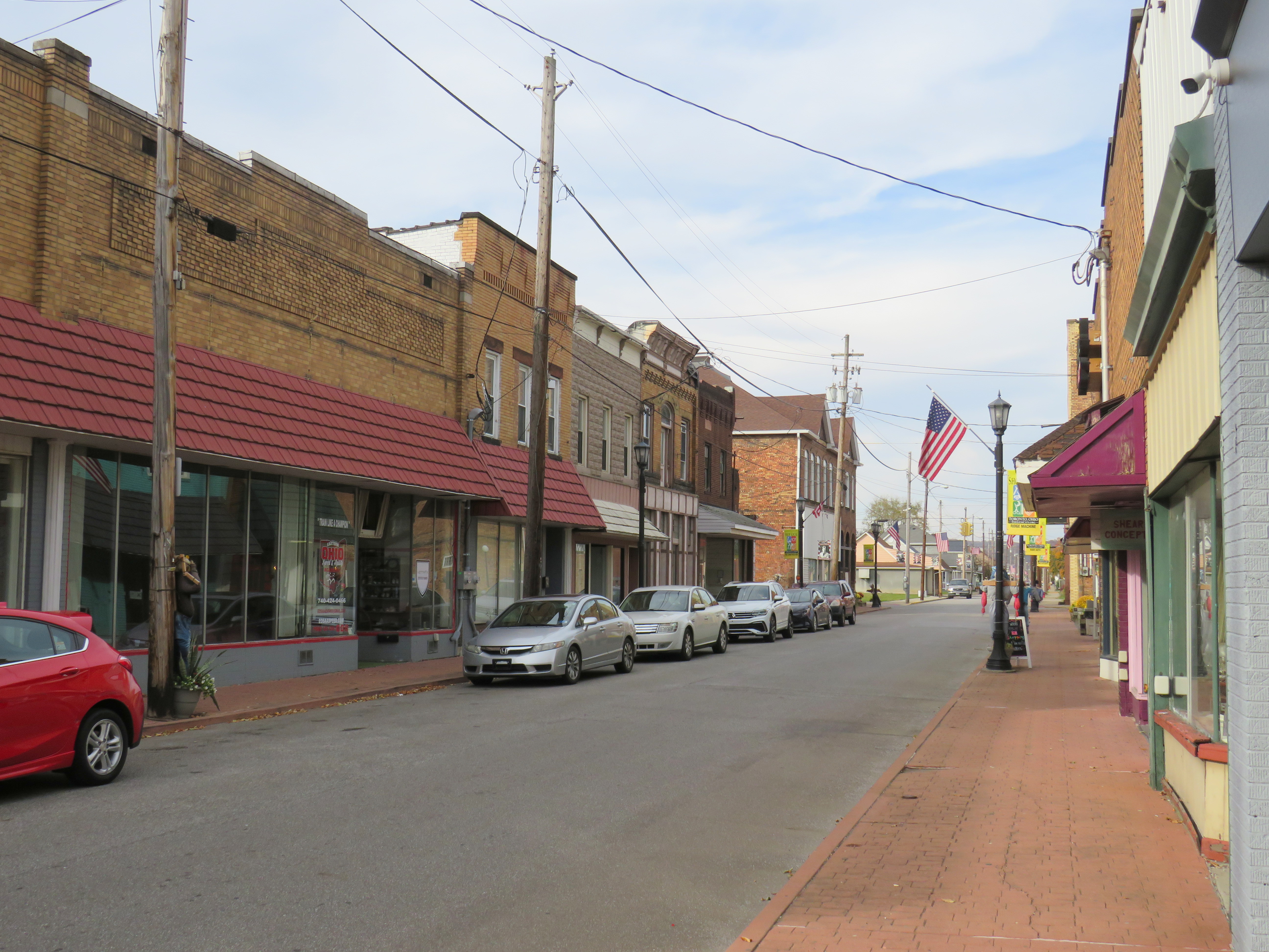
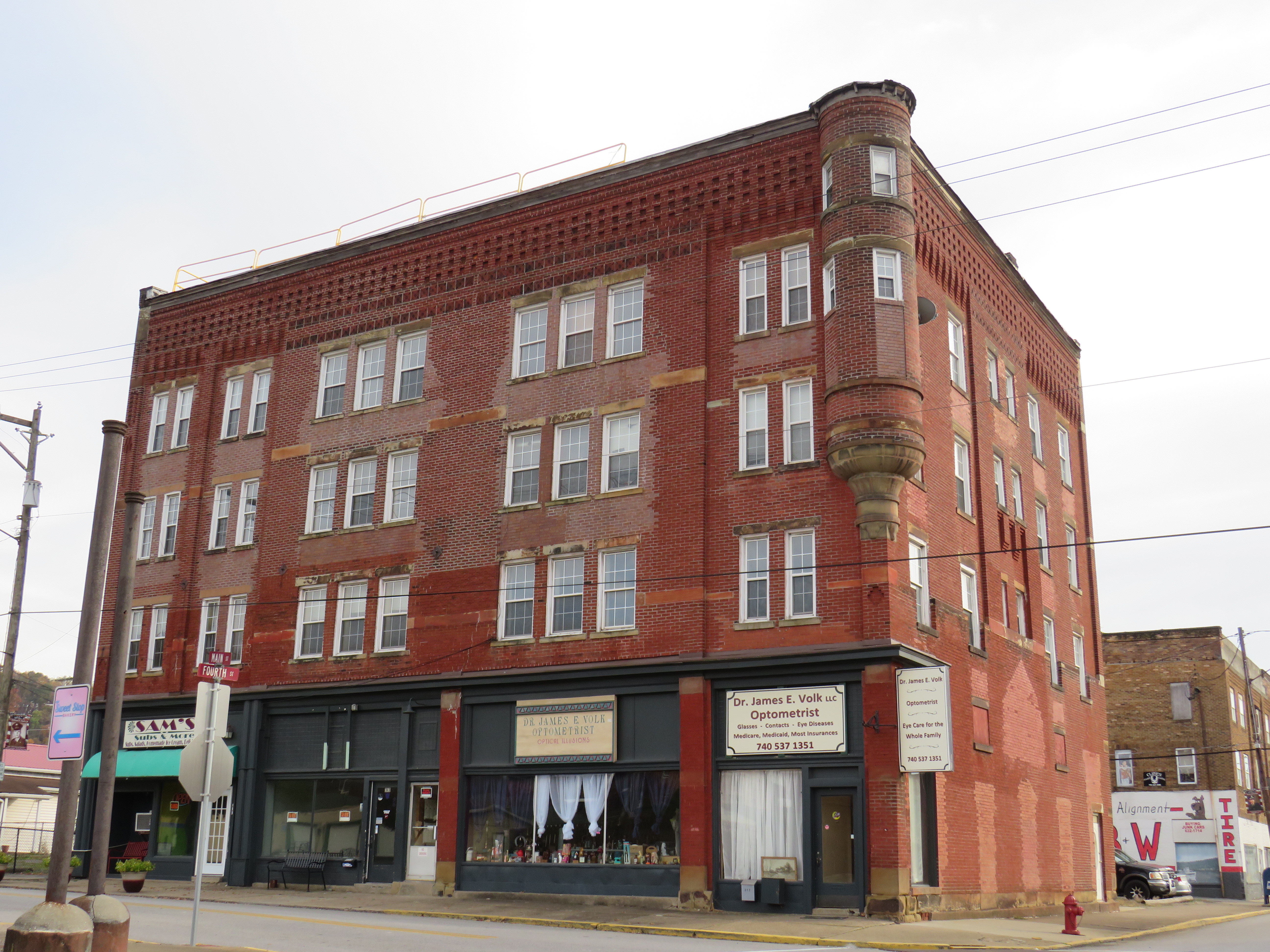
In 2012, Downtown Toronto had only a handful of stores, including a Dollar General, a bar, pizzeria, a Hallmark gift shop, and a hair salon. Apart from the bar (which I went into ten years ago), those businesses are still there today, but there was also a new barbecue restaurant, and a coffee shop. Up the street, a disused auto shop was transformed into a pretty good taco joint. Though downtown wasn’t especially busy, the parking spots along 4th Street were mostly full.
Downtown Toronto. A community garden sits on a vacant lot on the corner. 4th Street, Toronto’s main street The old hotel, now shops and apartments
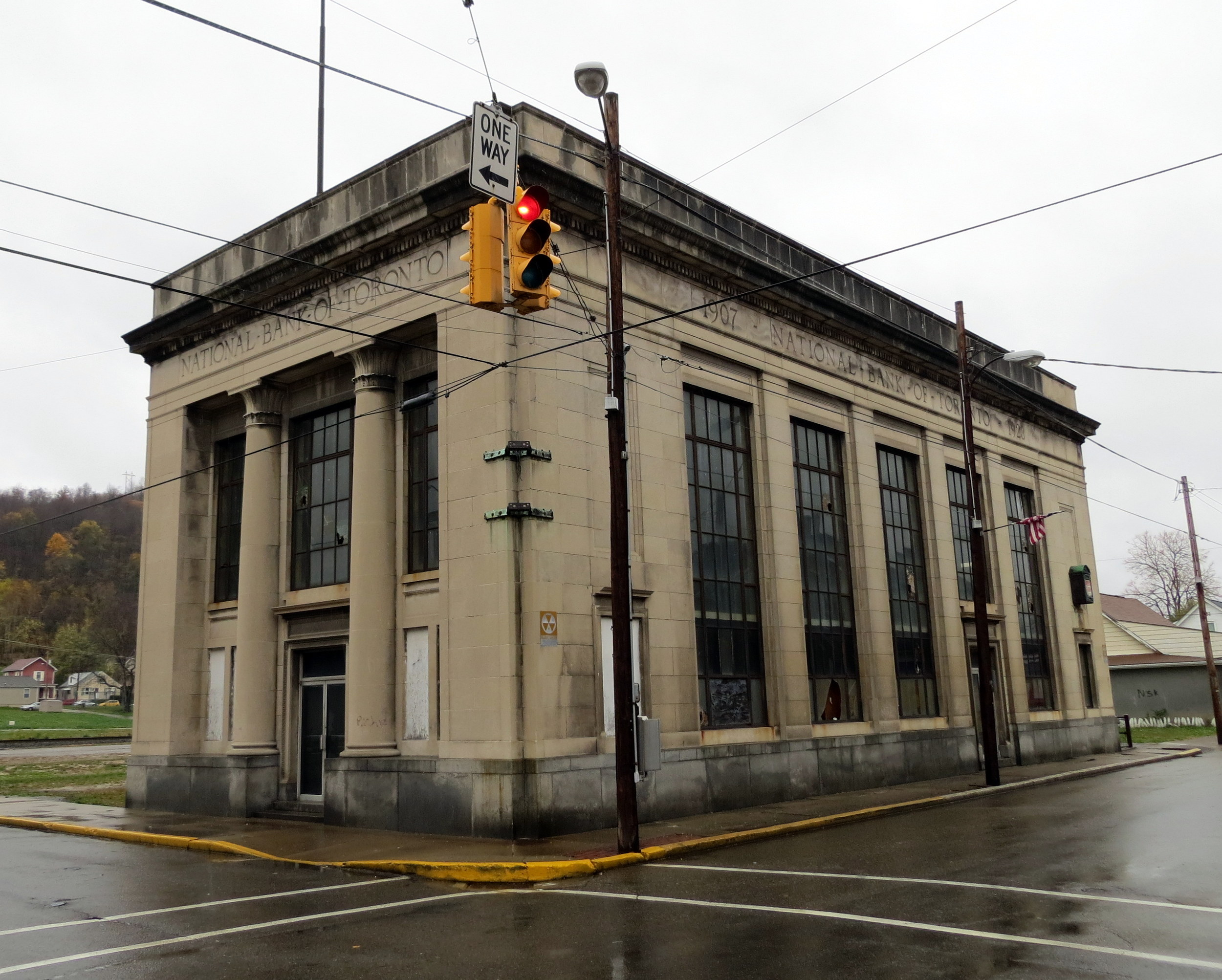
Sadly the abandoned, yet still handsome National Bank of Toronto building was torn down a few years ago. Otherwise, Toronto continues to hold its own, with a well-kept little downtown and more places to sit and eat than before.
Former National Bank of Toronto, October 2012Site of the former National Bank of Toronto, October 2022
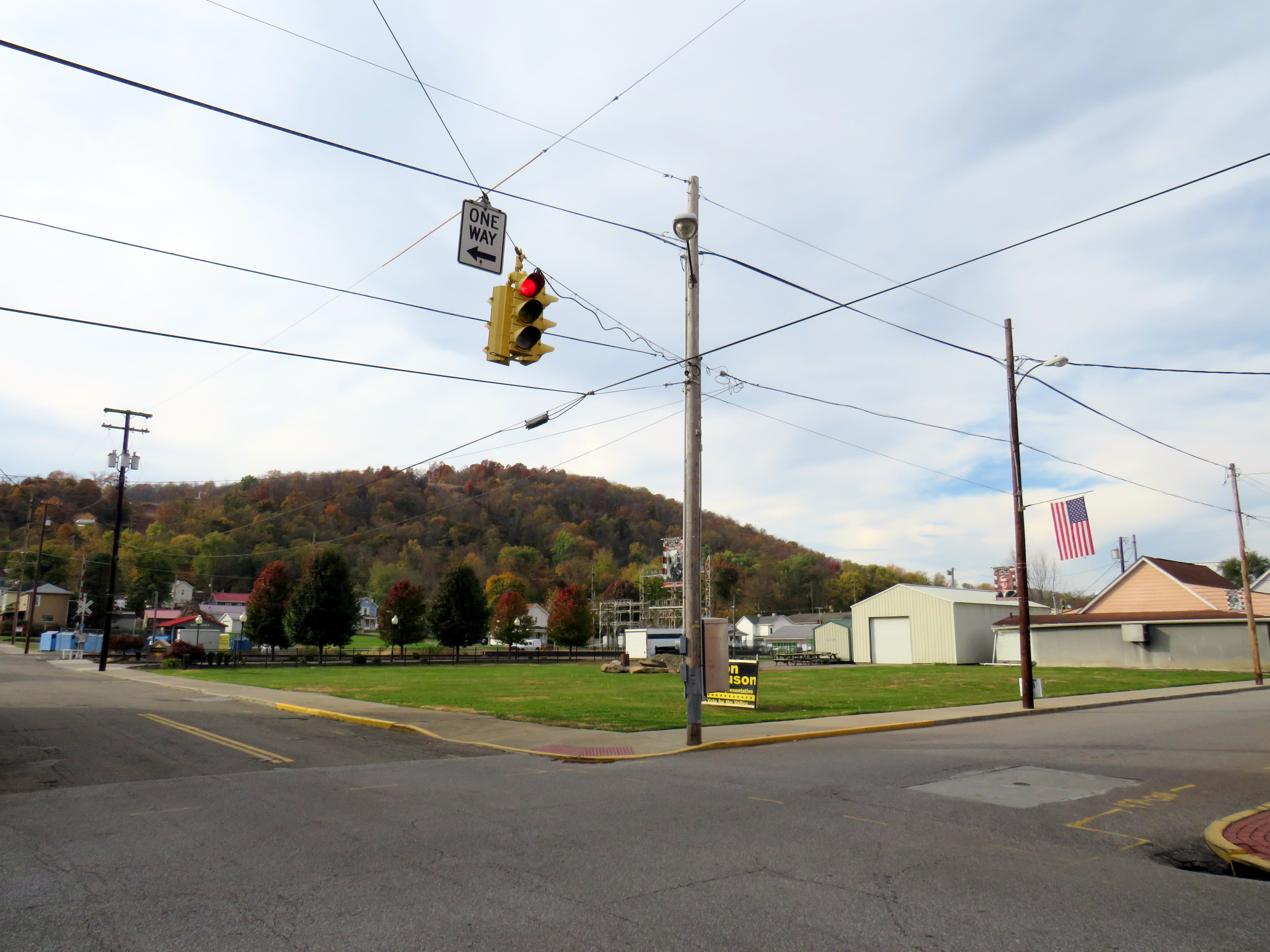
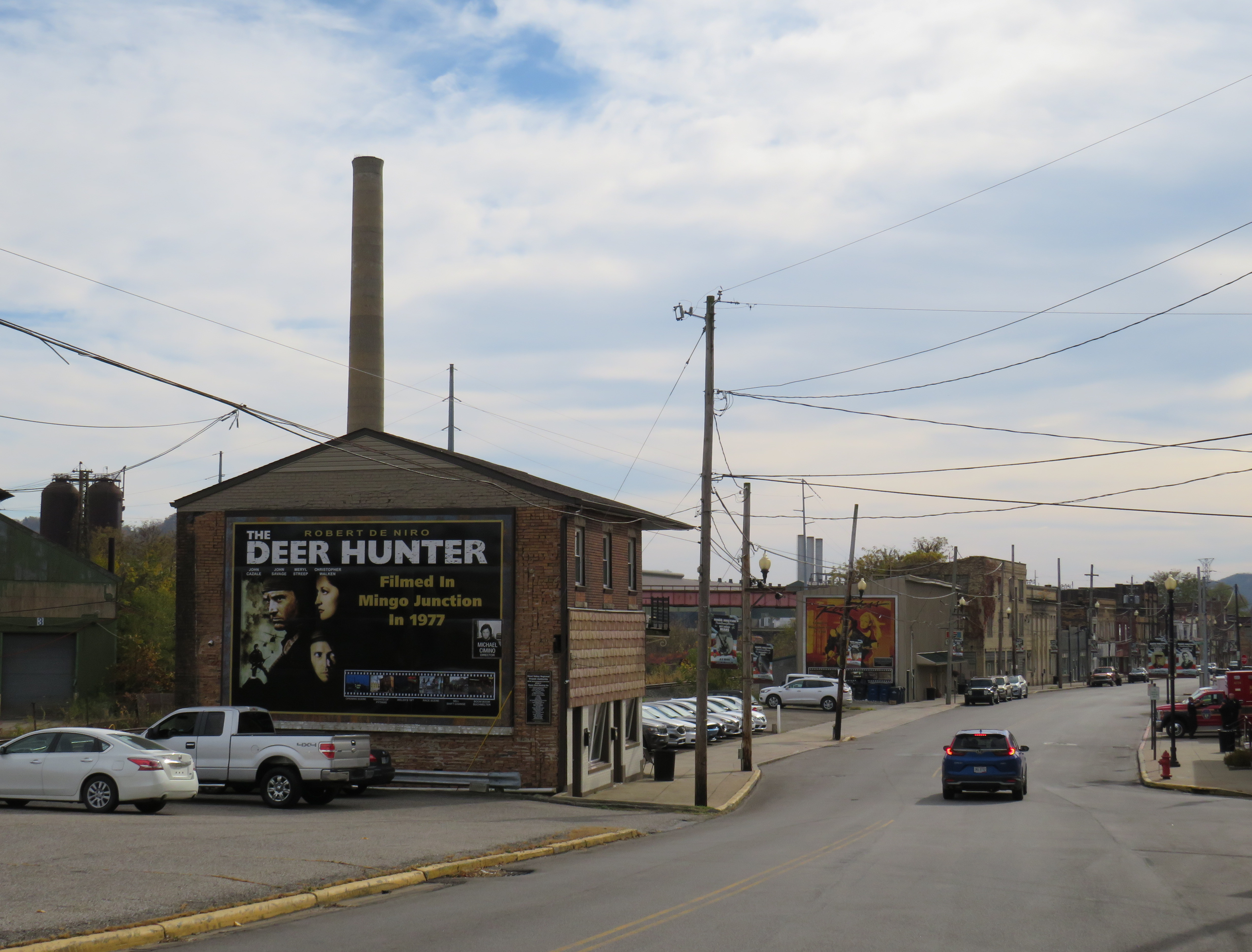
Just a few miles to the south is the town of Mingo Junction, Ohio, one of many industrial communities along the Ohio River in Pennsylvania, West Virginia, Ohio, and Kentucky. Mingo Junction is best known as a filming location for movies including the acclaimed 1977 film “The Deer Hunter.” The town now celebrates its cinematic history with large vinyl signs displayed on the north end of Mingo Junction’s main street.
Large sign celebrating the filming of “The Deer Hunter” in Mingo Junction, Ohio
While Toronto’s economy is based on a still-busy titanium mill, Mingo Junction is a old steel town, hit hard by the deindustrialization of northeast Ohio in the 1970s and 1980s. The condition of its Main Street
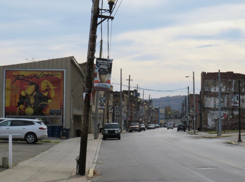
Mingo Junction’s Main Street, bypassed by a newer expressway. Another mural celebrates “Reckless,” a 1984 film also filmed in town.
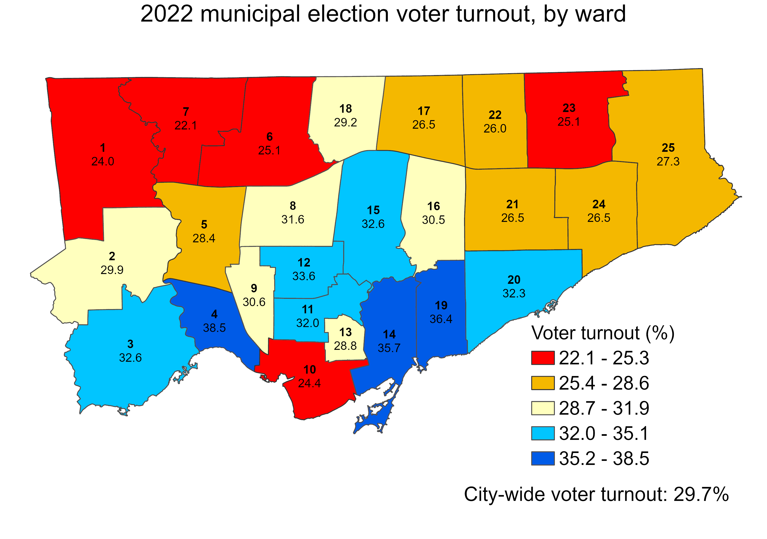
Ever since John Tory was elected mayor of Toronto in 2014, voter turnout in municipal elections has been in decline. In 2010, the year Rob Ford was elected mayor, turnout was 50.4 percent. Four years later, 54.7 percent of all eligible voters went to the polls to elect a new chief magistrate. However, in 2018, just 40.9 percent bothered to vote, and in 2022, turnout fell further, to just 29.7 percent.
With the recent release of detailed voter statistics from the 2022 municipal election in the Toronto Open Data catalogue, it is now possible to see how much turnout dropped in each ward.
I dig deeper into the last election’s dismal showing, and what it might mean for the upcoming mayoral by-election, at Spacing Toronto.