Marshall’s Musings

  • The end of Sarnia’s Eaton Centre

    The end of Sarnia’s Eaton Centre

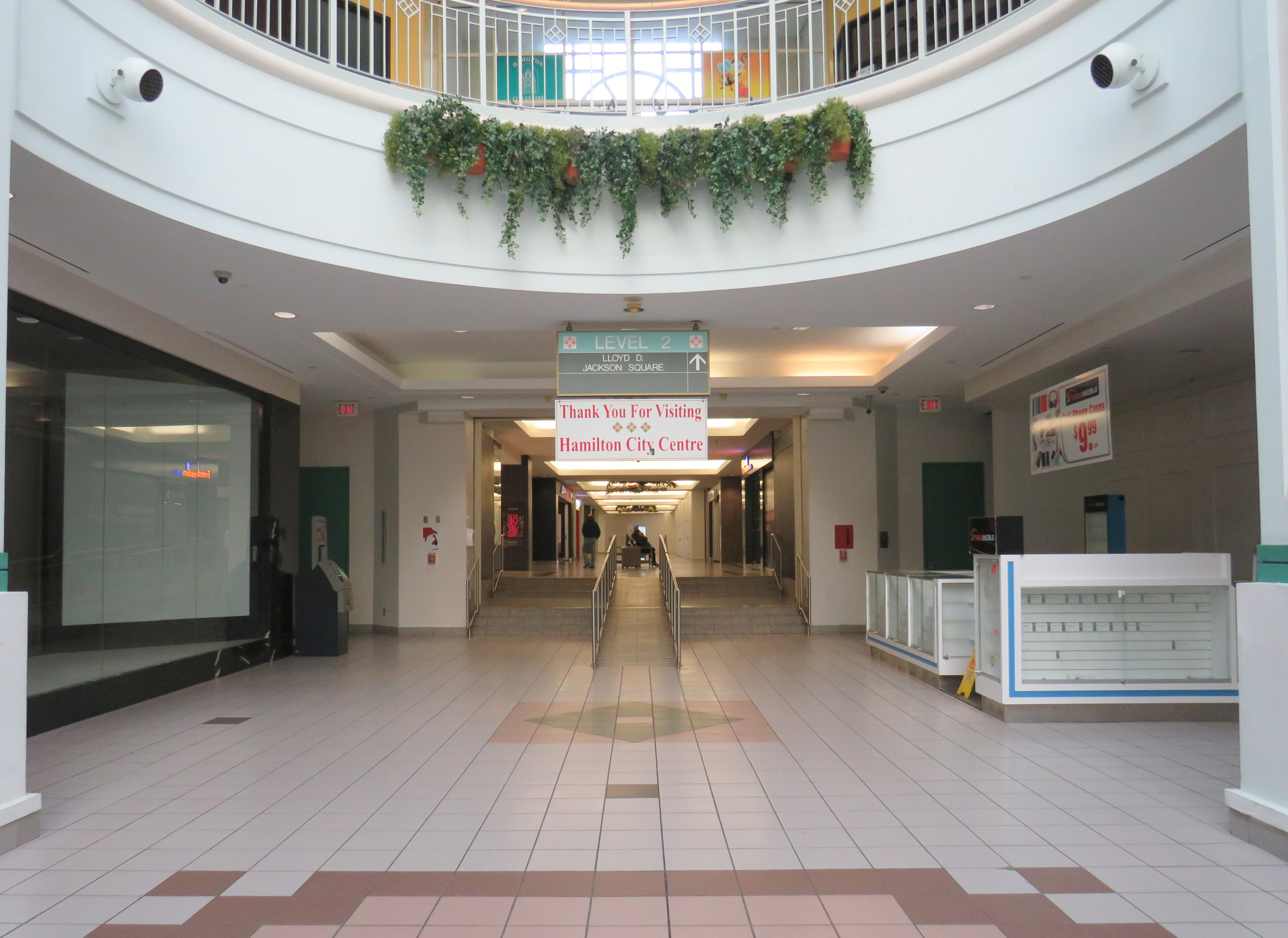
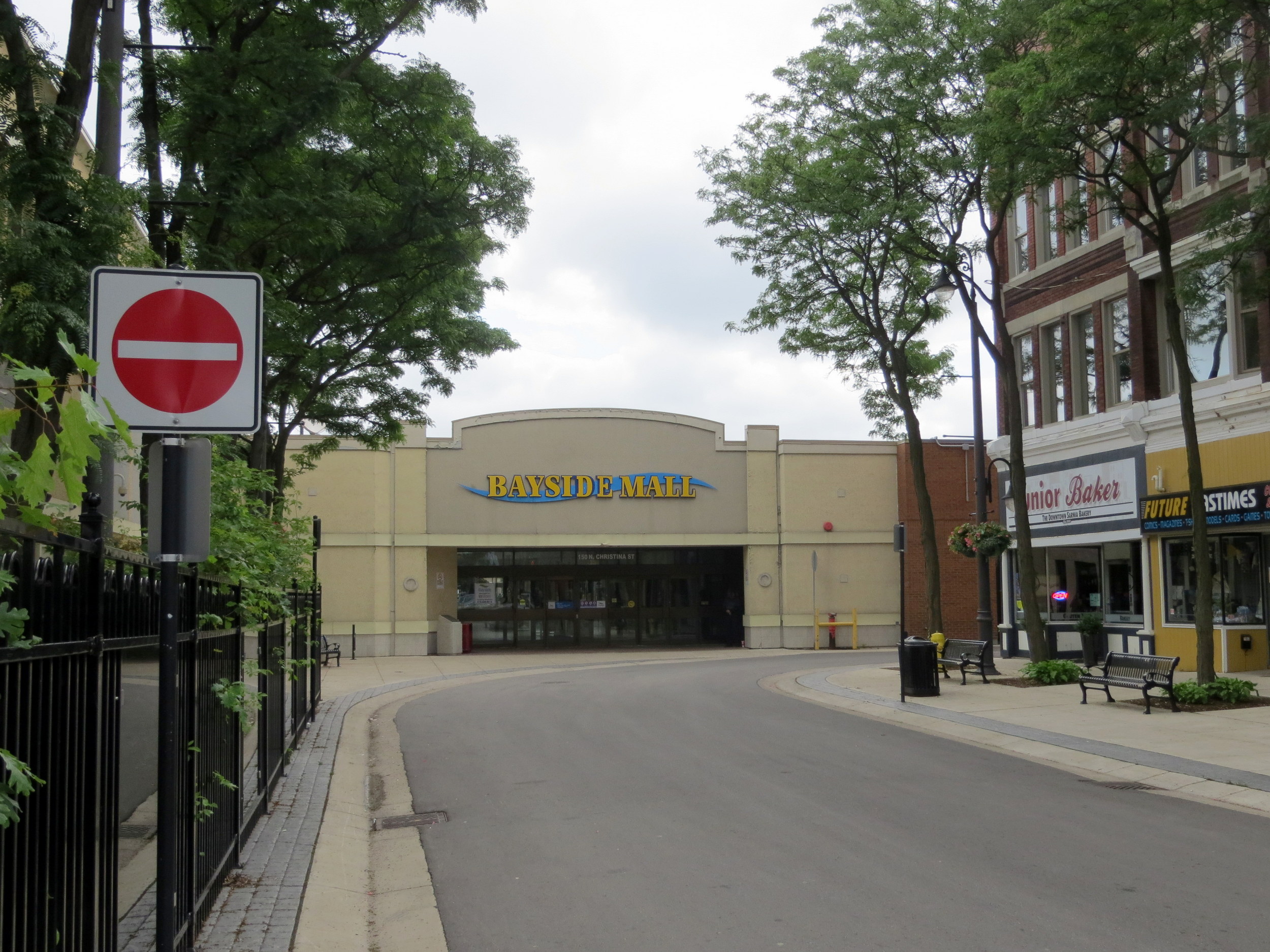
    Late last year, I wrote about the closure of the Hamilton City Centre mall, the last of Ontario’s downtown Eaton Centres to open. But Hamilton’s failed shopping centre wasn’t the only old downtown mall to close in recent years: Sarnia’s Bayside Centre, opened in 1982 as the Sarnia Eaton Centre, was recently demolished, with a seniors’ residence and long-term care home set to take its place.

    Bayside Mall in 2013

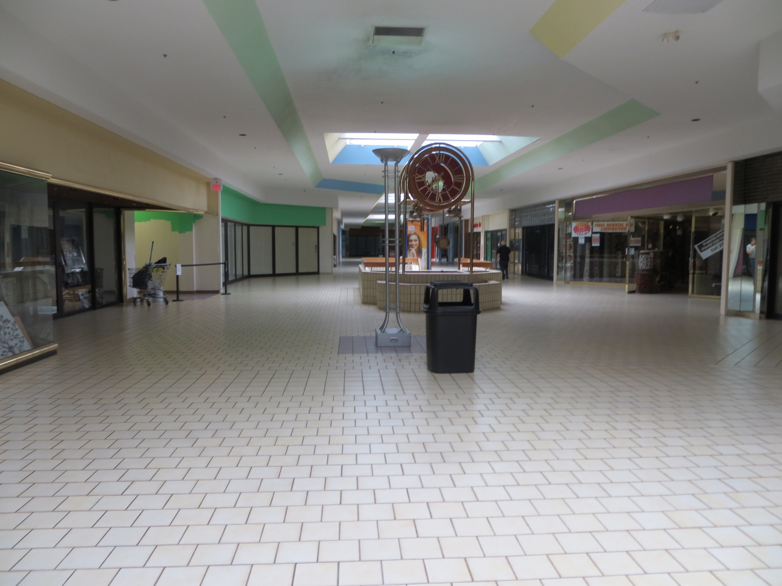
    I previously visited Sarnia’s Bayside Mall in 2013, when the mall was already mostly dead. Community uses, such as a local museum, a Canadian Blood Services clinic, a seniors’ drop-in centre, and a March of Dimes office predominated, with only Hong Kong Express and Subway left in the food court, and a few other shops — a rug store, an optician, a beauty salon, and a pharmacy — scattered amongst the vacant storefronts. The old Eaton’s department store was already converted into offices for Lambton County’s social services department.

    The old fountain at the main entrance to Bayside Mall in 2013.

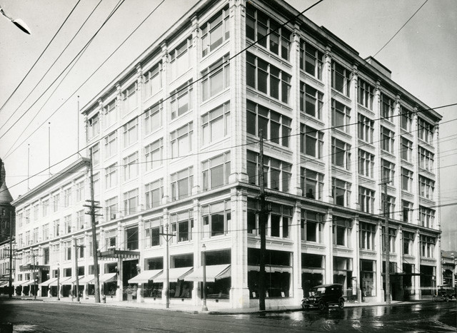
    As I discussed previously on this website, there was a downtown redevelopment boom across Ontario in the 1970s and 1980s, with municipalities and the province eager to support the construction of new shopping centres to help them compete with suburban malls.

    The Sarnia Eaton Centre was the first of several malls funded by the Ontario Downtown Redevelopment Program, though previous downtown shopping centres, such as Hamilton’s Jackson Square and the Sudbury City Centre, were built with municipal support.

    The case for Sarnia Eaton Centre was always weak, but it was the result of inter-municipal rivalry as much as it was an attempt to revitalize Downtown Sarnia. In the 1970s, Lambton Mall opened in the city’s outskirts, near the intersection of Highways 40 and 402. But Lambton Mall was built outside the city limits, in suburban Sarnia Township. Lambton Mall’s anchors included Sears, Canadian Tire, and Toys R Us.

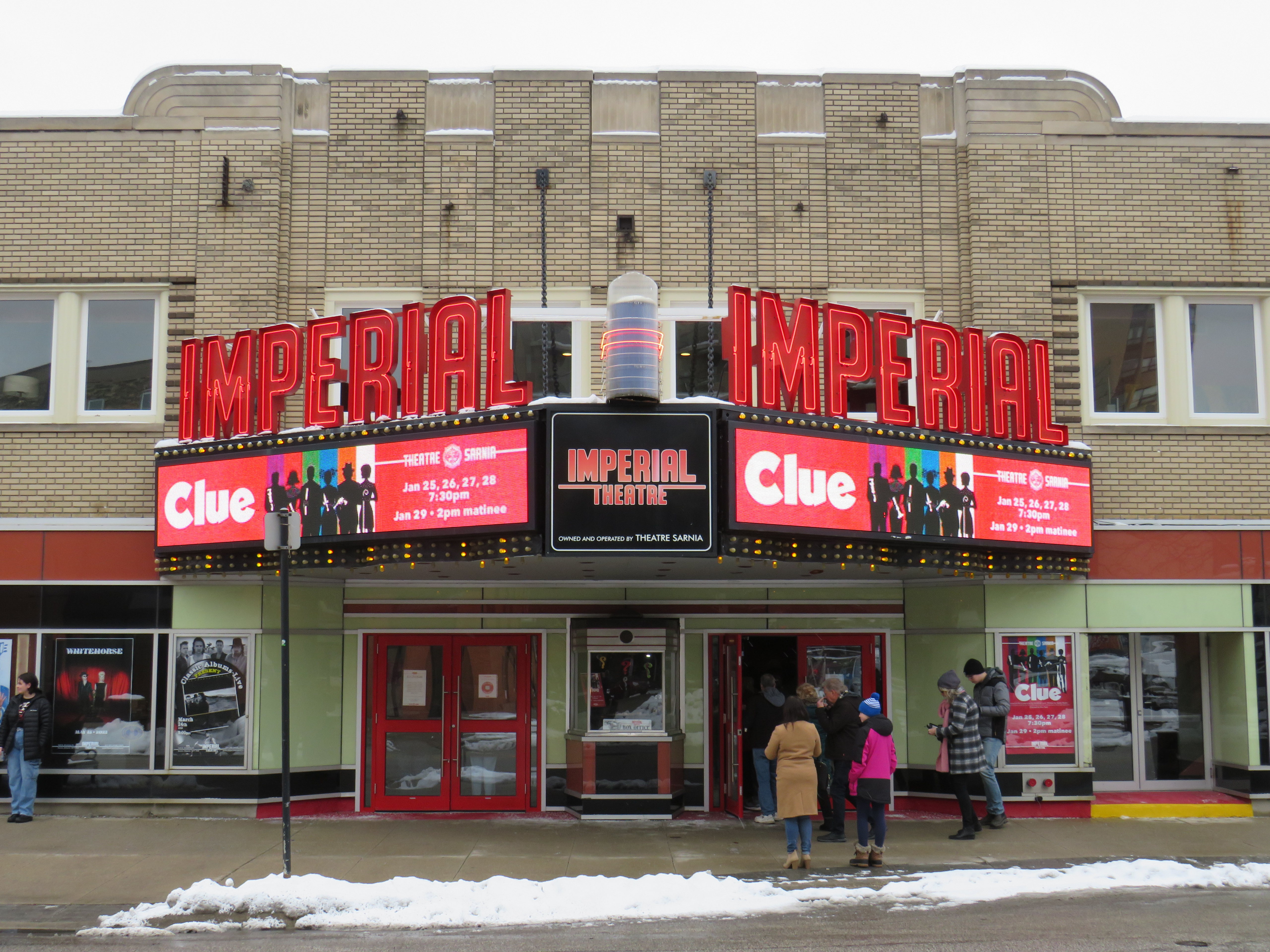
    While Sarnia Township’s population was growing due to residential, industrial, and institutional growth (Lambton College’s main campus was also established in the township, near Lambton Mall), the City of Sarnia’s population declined. Along with the new Eaton Centre, the city also encouraged new highrise residential development in the downtown core, and two new office buildings were also constructed. The city – with support from Imperial Oil, a major employer – renovated the old movie theatre, converting it to a playhouse for local productions and touring shows.

    The Imperial Theatre remains a popular attraction

    When it opened in 1982, Sarnia Eaton Centre was the centrepiece of Sarnia’s downtown comeback. It filled in nearly four blocks of Downtown Sarnia, with Lochiel Street closed between Christina and Vidal Streets, and Victoria Street closed north of Cromwell.

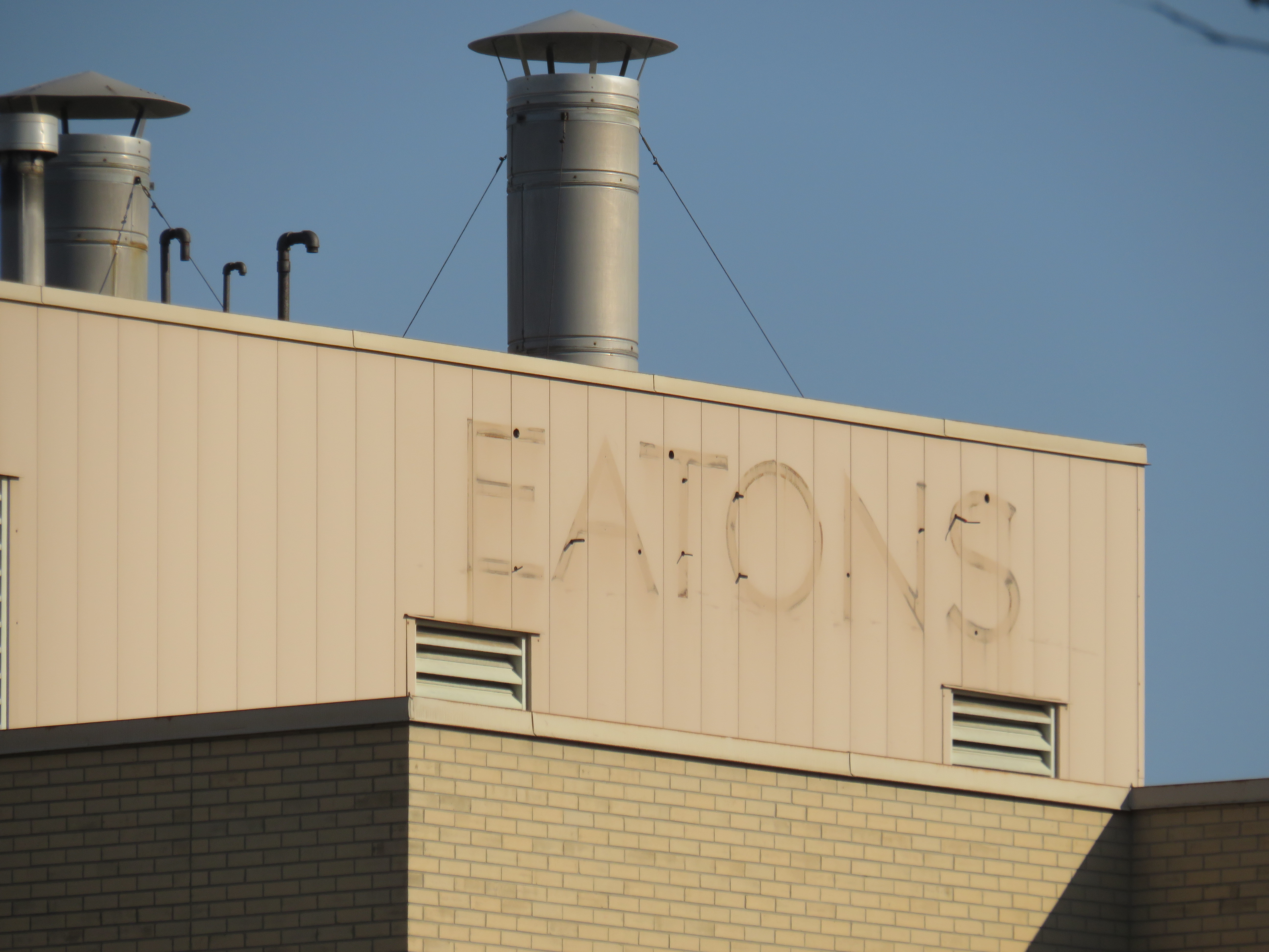
    The mall was anchored, of course, by Eaton’s, a smaller, two-storey store with 91,470 sq. ft. of floor space (just under 8500 square metres), and an A&P supermarket on the southern end. Sarnia Eaton Centre’s 1993 Canadian Directory of Shopping Centres, showed that the mall still had a healthy assortment of national retailers, along with some local businesses. But many retailers refused to renew their store leases, and when Eaton’s entered bankruptcy for the first time in 1997, the Sarnia store was among the first to close.

    The City of Sarnia merged with Sarnia Township in 1991, while the area surrounding Lambton Mall continued to grow as the region’s commercial centre. Big-box stores such as Walmart and Home Depot clustered around the older mall, and even with Sears Canada’s closure, Lambton Mall continued to do well, with Marshalls/Home Sense taking over the old Sears store.

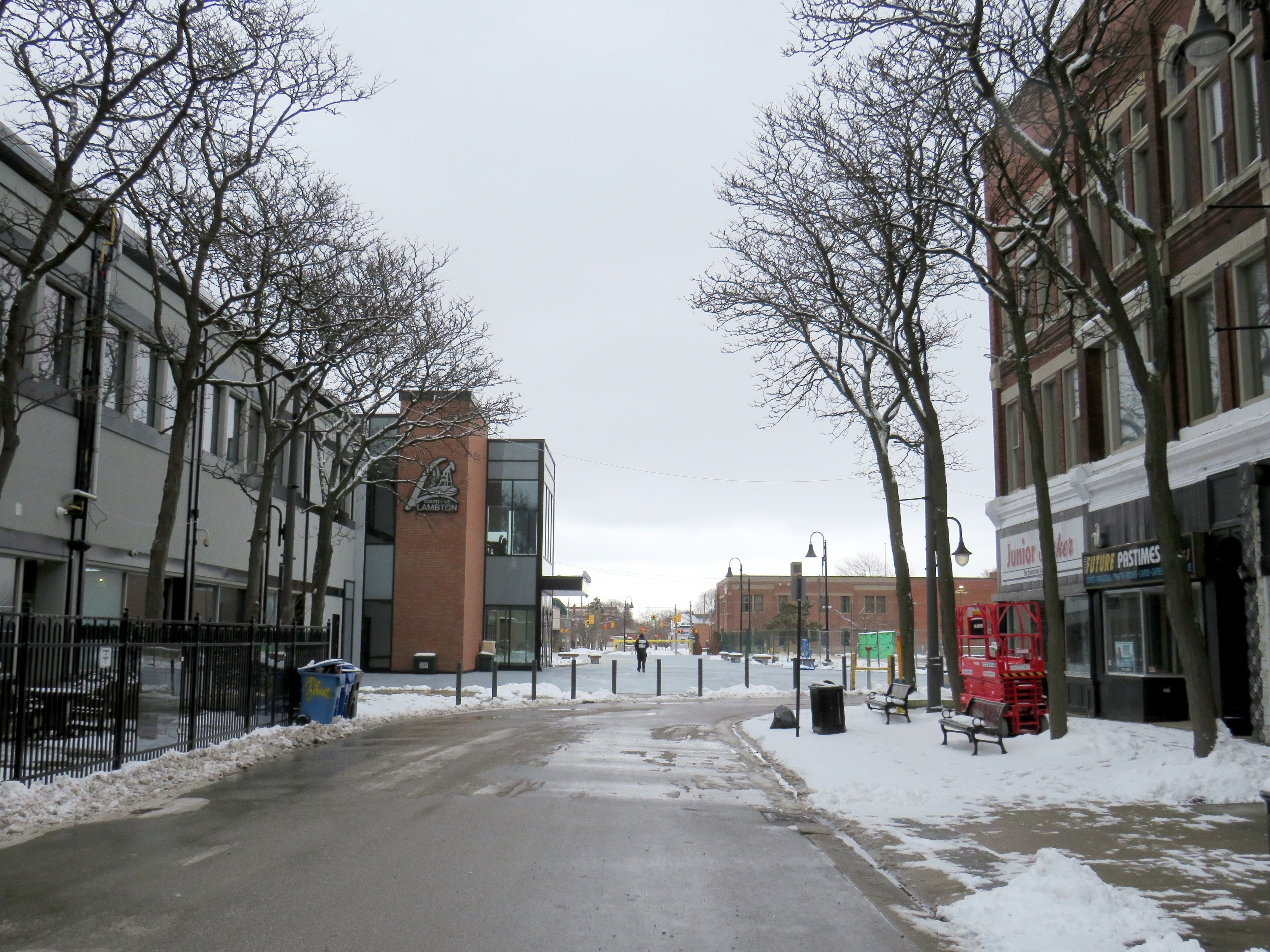
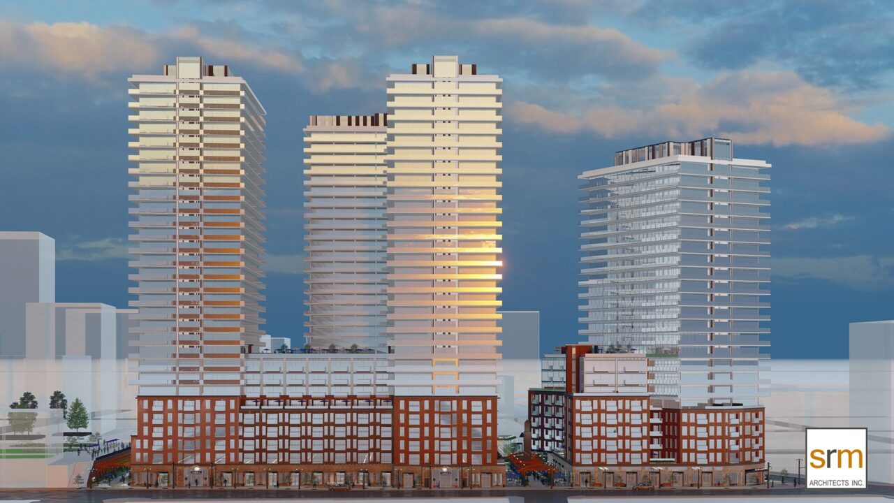
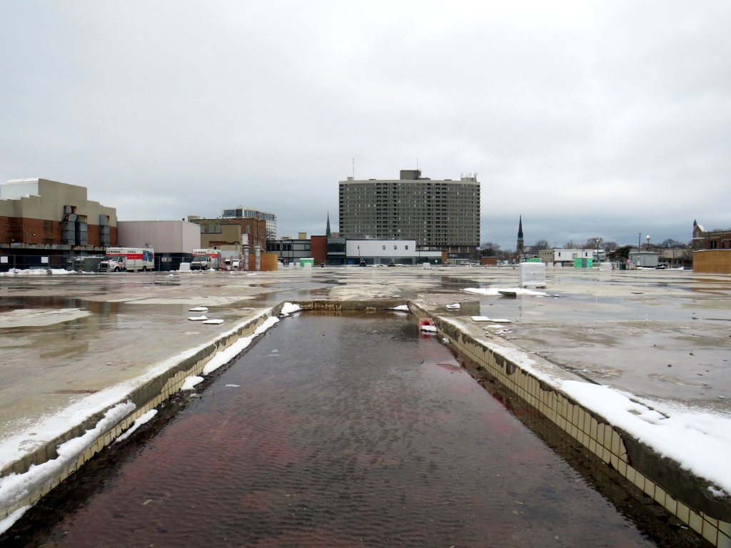
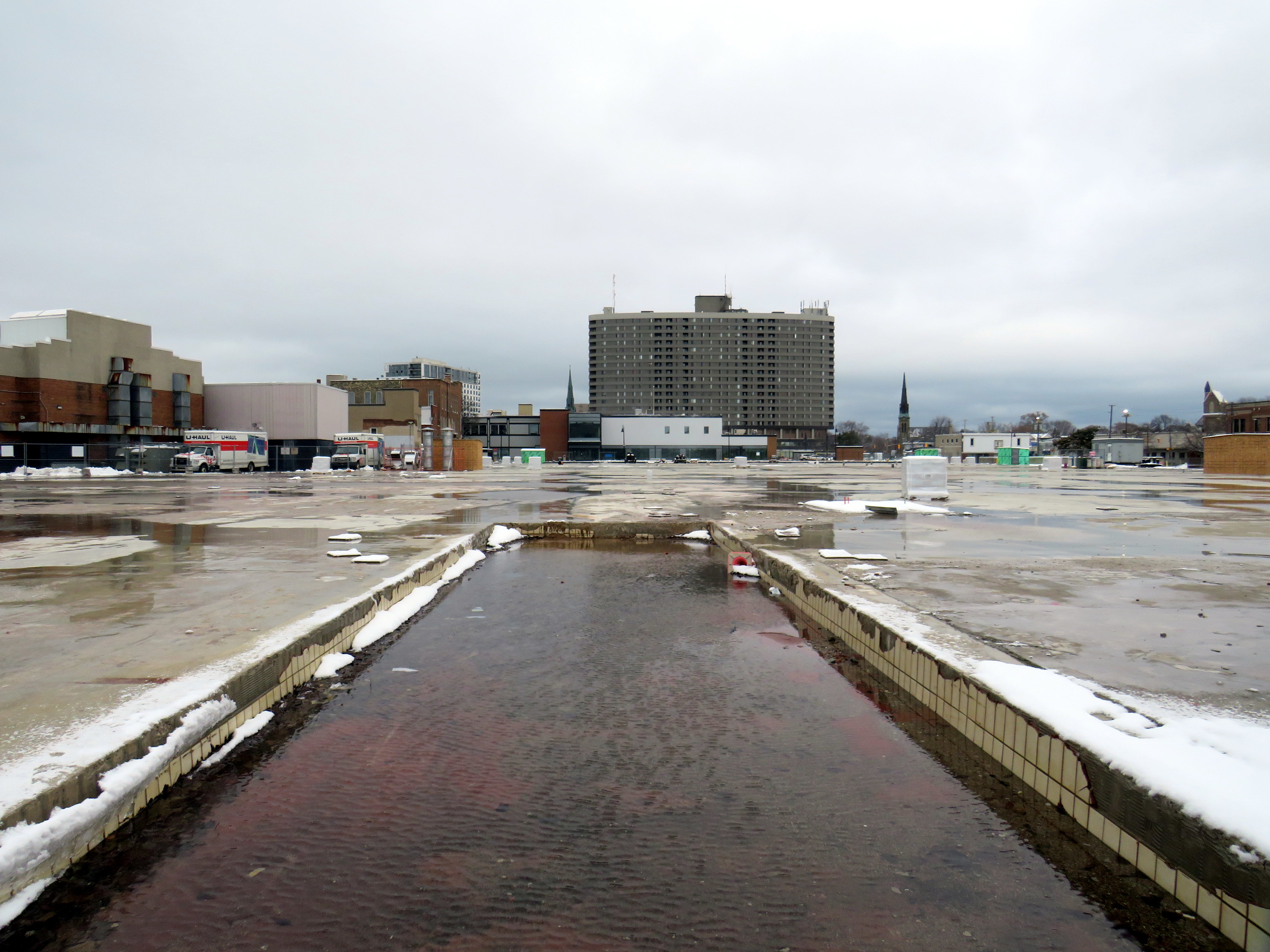
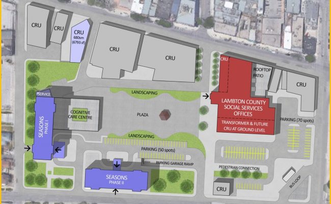
    The Bayside Mall property was purchased by Seasons Retirement Communities in 2017, and most of the mall was demolished in 2021-2022. Lambton County, which operated its social services offices in the former Eaton store, expanded its footprint, with a new municipal courthouse located next to the old Eaton’s store, which was renovated.

    Lochiel Street has been partially restored as a pedestrian walkway across the site, while the southern half of the old mall will be redeveloped for mid-rise seniors’ homes, with a central plaza.

    Map showing the redevelopment of Bayside Mall, with the Lambton County building, in red, already complete in early 2023. The top of the map faces west.

    Bayside Centre is certainly not the only mall property in Ontario to be redeveloped for new housing — Hamilton City Centre will soon come down for similar reasons, and other older malls will soon follow — but it’s among the first.

    Meanwhile, Downtown Sarnia will continue to hold its own. It has a few nice restaurants, cafes and pubs, and the highrise development of the 1970s and 1980s ensures that there’s a local population that will frequent the businesses there. The addition of seniors housing won’t hurt either.


    Below is the list of tenants at Sarnia Eaton Centre in 1992, obtained from the 1993 Canadian Directory of Shopping Centres, published by Maclean-Hunter. In 1992, the collection of retailers was still quite strong, largely driven by Cadillac Fairview’s leasing team.

    Anchors

    A&P (26,512 sq ft), Eaton’s (91,470 sq. ft)

    Fashions and footwear
    Children’s wear: Just Kids
    Unisex/family wear: Le Chateau, D’Gala, Pantorama, Stitches, Thrifty’s
    Ladies’ wear: Fairweather, Irene Hill, Just Petites Lady Foot Locker, Lindor, Reitmans, Smart Set, Suzy Shier
    Menswear: Tip Top
    Footwear/leather goods: Agnew, Baronessa, Bata, Belinda & Brother, Joggers, Kinney, Mr. Minit Shore Repair
    Jewellery/accessories: Ardene, People’s

    Other retailers
    Books/stationery: Carlton Cards, Garfield, WH Smith
    Health and beauty: Caryl Baker Visage, Shoppers Drug Mart
    Department store/mass merchandiser: Marks & Spencer, A Buck Or Two
    Electronics: Radio Shack
    Entertainment: Fun & Games
    Furniture & furnishings: Brass Collections
    Gifts: Things Engraved
    Hardware/paint & paper: St. Clair Paint and Wallpaper
    Housewares: The Royal Douton Store, Stokes
    Music/ records & tapes: Discus, Music World
    Pets: Tropicarium Pet Centre
    Photo/camera: Black’s, Japan Camera
    Restaurants & fast food: Elephant & Castle, Global Donuts, Hamby’s, Hong Kong Express, Kernels, Mykie’s, Viva Pasta
    Specialty food & drink: Laura Secord, mmmarvellous mmmuffins, Second Cup

    Services
    Banks/financial: Canada Trust, TD Bank
    Hairstyling/esthetics: Regis Hairstylists
    Medical/dental: Tridont Dental
    Travel: Marlin Travel
    Misc: Infoplace

  • I went back to Toronto

    Back in October 2012, I paid a visit to Toronto, Ohio, population 5,091. Soon after my trip to the Ohio River Valley, I wrote about my visit for Spacing Toronto. A decade later, in October 2022, I returned to Toronto while on a trip to nearby Pittsburgh.

    The small Ohio community was originally named Sloan’s Station, but when it was incorporated as a city, they chose “Toronto” because local businessman W.F. Dunspaugh, a Toronto (Ontario) native, thought his hometown was “a place worth emulating.” Toronto, Ohio is the only other city named Toronto, but other Torontos exist, including the town of Toronto, South Dakota (population 212) and the town of Toronto, New South Wales, Australia (population 5,161).

    In 2012, Downtown Toronto had only a handful of stores, including a Dollar General, a bar, pizzeria, a Hallmark gift shop, and a hair salon. Apart from the bar (which I went into ten years ago), those businesses are still there today, but there was also a new barbecue restaurant, and a coffee shop. Up the street, a disused auto shop was transformed into a pretty good taco joint. Though downtown wasn’t especially busy, the parking spots along 4th Street were mostly full.

    Downtown Toronto. A community garden sits on a vacant lot on the corner.
    4th Street, Toronto’s main street
    The old hotel, now shops and apartments

    Sadly the abandoned, yet still handsome National Bank of Toronto building was torn down a few years ago. Otherwise, Toronto continues to hold its own, with a well-kept little downtown and more places to sit and eat than before.

    Former National Bank of Toronto, October 2012
    Site of the former National Bank of Toronto, October 2022

    Just a few miles to the south is the town of Mingo Junction, Ohio, one of many industrial communities along the Ohio River in Pennsylvania, West Virginia, Ohio, and Kentucky. Mingo Junction is best known as a filming location for movies including the acclaimed 1977 film “The Deer Hunter.” The town now celebrates its cinematic history with large vinyl signs displayed on the north end of Mingo Junction’s main street.

    Large sign celebrating the filming of “The Deer Hunter” in Mingo Junction, Ohio

    While Toronto’s economy is based on a still-busy titanium mill, Mingo Junction is a old steel town, hit hard by the deindustrialization of northeast Ohio in the 1970s and 1980s. The condition of its Main Street

    Mingo Junction’s Main Street, bypassed by a newer expressway. Another mural celebrates “Reckless,” a 1984 film also filmed in town.
  • Voter turnout in the 2022 municipal election

    Ever since John Tory was elected mayor of Toronto in 2014, voter turnout in municipal elections has been in decline. In 2010, the year Rob Ford was elected mayor, turnout was 50.4 percent. Four years later, 54.7 percent of all eligible voters went to the polls to elect a new chief magistrate. However, in 2018, just 40.9 percent bothered to vote, and in 2022, turnout fell further, to just 29.7 percent.

    With the recent release of detailed voter statistics from the 2022 municipal election in the Toronto Open Data catalogue, it is now possible to see how much turnout dropped in each ward.

    I dig deeper into the last election’s dismal showing, and what it might mean for the upcoming mayoral by-election, at Spacing Toronto.

  • Sean’s strong mayor agenda for a new era

    Who knew, just two weeks ago, that Torontonians would be returning to the polls to elect a new mayor of Toronto?

    Looking back on John Tory’s last eight-and-a-half years in office, the biggest disappointment might have been that he spent so little of the political capital that he had accumulated after decades as a backroom power broker, corporate executive, provincial party leader, talk radio host, and supporter of NGOs such as CivicAction and the United Way. Despite his promise as a business-friendly, progressive conservative leader who knew how to build partnerships and work with other levels of government, there’s little to show for it. SmartTrack? That was always a fantasy which has now been mostly forgotten. An improved public realm, including a new Rail Deck Park? That never happened either. Heck, we can’t even get a decent WiFi connection in the subway, never mind a cell signal, despite the mayor’s close ties with the telecommunications industry.

    To be fair, there are a few things one can point to that got done during Tory’s tenure: new bike routes on Bloor-Danforth, Yonge, and University Avenue, some improvements to the TTC surface network, the King Street transit priority pilot, and surprisingly good pandemic responses, including excellent city-run vaccine clinics, weekend street closures for active transportation, and new street-level patio space to help restaurateurs recover from pandemic shutdowns.

    But in 2022, the ActiveTO street closures faded away, partially due to influence from the Toronto Blue Jays management (note: the baseball team and its stadium are owned by Rogers), the King Street transit priority corridor deteriorated from neglect. As the homelessness crisis worsened, Tory and his allies backed repressive and violent clearances of public parks, without supplying enough alternatives for housing or supporting the most vulnerable in this city. A series of municipal budgets in which property taxes were kept low while other expenses piled up has caused this city to become reliant on the support of the province and federal governments to bail us out.

    With Tory gone — brought down by his own error in judgment — we will have thirteen lost years in which Toronto will have to catch up. That’s a tall order.

    I can’t claim to have all the answers, but I have a few ideas to share to help make Toronto a safer, more fun, more comfortable, and more humane place to live. If I were a mayor with strong powers, here’s what I would do:

    • A progressive property tax system. An unfortunate reality for Ontario municipalities is that they have very limited tools for raising revenue: property taxes, user fees (like TTC fares and recreation fees), and in Toronto’s case, vehicle registration fees. Municipalities are also given grants from the province and federal government for specific purposes, such as providing mandated services. Unlike sales, income, and business taxes, property taxes do not grow with the economy, so municipalities must raise the property tax mill rate every year to keep up with inflation and/or fund new or expanded services. However, no matter the assessed worth of the property, the tax percentage remains the same.

      A progressive property tax system can be used then to raise more money from higher-valued properties. For example, for residential properties, a basic tax rate could apply for the assessed value up to $1 million. Beyond that first $1 million, a higher bracket comes into effect. Such a policy could minimize tax increases for those in smaller or starter homes. To encourage the construction of secondary suites, high-value properties could then get tax breaks for every additional self-contained unit on site, provided they are inspected and meet fire code. A progressive property tax system could help raise revenue, encourage the construction of more housing units, and provide a more equitable revenue source.
    • A real Vision Zero plan. Putting up “Senior Safety Zone” signs and lowering speed limits on four and six lane streets does little when the roadway remains designed for high speeds, and motorists race through intersections with limited enforcement. To protect pedestrians and cyclists (as well as other drivers and their passengers), the roads themselves must be re-engineered for lower speeds. This means “daylighting” pedestrian crossings by ensuring crosswalks are always well-lit, crosswalks raised where possible to improve visibility and curbs extended to both reduce the amount of roadway that pedestrians must cross, and signal to drivers to slow down. Furthermore, a blanket right-turn-on-red prohibition, like those in New York, Montreal, and Mexico City, would eliminate a common cause of pedestrian-motorist collisions and make those new leading pedestrian intervals at Toronto’s street corners fully effective.
    • Prioritize transit and clean up the TTC. When I say “clean up the TTC” I don’t mean throwing more cops at the problem of safety on our subways, streetcars and buses. Under CEO Rick Leary’s leadership, it feels as if the TTC has given up on many of the gains brought forward by Andy Byford. Customer service has fallen by the wayside, wait times have increased, the streetcar network is faltering with trams running slower than ever before, communications have become unreliable, and customer confidence in the system has fallen. When customers no longer feel valued, they themselves give up.

      After cancelling upcoming service cuts contained in Tory’s last budget, one of the easiest things to do to show that transit riders matter is making King Street great. This means installing permanent streetcar platforms in the curb lanes along the streetcar priority zones and making it even more clear that drivers are prohibited from using King as a throughway. Eliminate the night time taxi exception to simplify signage, and automate enforcement with video cameras mounted at intersections and on streetcars themselves, as is done on some Select Bus Service routes in New York.

      Haffiz A., via Twitter, shows how King Street could look:

      https://twitter.com/trainguy89/status/1627147434802520066?s=20

      The TTC also needs to modernize its street railway infrastructure so that streetcars no longer have to stop and crawl across every track intersection. Electric dual-blade junctions and wayside signals — used just about everywhere else — allow streetcar operators to know which way the track is pointed ahead of the intersection and can allow streetcars to glide through junctions at regular traffic speed.

      Finally, get TTC staff and all councillors riding the TTC on a regular basis. Meet passengers. Let them know they matter, and inform them of improvements, and be visible.
    • Build affordable housing. Lots of it. Use increased revenues from the progressive tax system proposed above to build more affordable housing directly (instead of just relying on market solutions like inclusionary zoning), including the co-operative home model. While doing so, shame the provincial and federal governments for pulling out of funding new construction in the 1990s. The city owns lots of land in good areas, such as Green P parking lots, TTC stations, works yards, suburban office spaces, and even on parts of municipal golf courses, which, of course, should be converted to general year-round public spaces.
    • Stand up to the bullies at Queen’s Park. One of Mayor Tory’s biggest failures was to ignore the province’s meddling in Toronto’s affairs and impose the province’s unpopular plans upon the city. This city should have the right to decide the composition of its own council; there was not nearly enough protest from city leadership when Doug Ford forced a cut in council from 47 to 25 (which will likely go down to just 24 in 2026) after an unprecedented level of public consultation in shaping the approved boundaries. Instead of waiting forever for a ministerial zoning order that was never going to come for a modular housing project in North York, real leadership would have gotten it built, the province be damned. Call their bluff.

      Meanwhile, Premier Doug Ford — the man Tory beat to become mayor in 2014 — is imposing his own ideas on Ontario Place, provincially owned public lands on Lake Ontario. If one could not get Rail Deck Park built, Ontario Place could have been the site for a renewed public realm, much like some of New York City’s new waterfront parks. Some vision, some willingness to spend political capital, and a good advocacy campaign could have stopped the plans for an overbearing private megaspa that effectively closes off major portions of our public waterfront.
    New York City’s “Little Island” could have been an inspiration for a renewed Ontario Place

    There will be some people who will be happy that I am not serious about running for mayor. For one, I don’t have the people skills, the connections, nor the energy to make a serious bid. But if I see some of the ideas suggested above make it into a mayoral platform, I would not be above making a personal endorsement.

  • A better Bramalea Station, finally

    A better Bramalea Station, finally

    I have written a lot about Bramalea GO Station on this website. In 2016, I wrote about the poor pedestrian, cycling, and transit access to the station; in 2020 I was stranded at the station because of poor train-bus connections, and in 2021, I compared the construction of a new parking garage at Bramalea to a new parking lot at nearby Brampton GO Station.

    But in January 2023, I returned to Bramalea GO Station and came away feeling satisfied. Metrolinx has finally built a Bramalea GO Station that works. Now it is time to use the rebuilt station to its full potential.

    (more…)
  • Middle America’s transit oddities

    Pittsburgh Regional Transit Red Line train in the Brookline neighbourhood

    In 2022, with travel restrictions eased, I had the opportunity to take several road trips throughout the Northeast and Midwestern states, from New York and Maryland to Kentucky and Michigan. Previously on this site, I wrote about my visit to Philadelphia’s Rail Park, a lesser-known, yet ambitious project to repurpose former Reading Railroad corridors in the city’s north end. I also wrote about Dayton’s trolley bus network, which, if operated to its full potential, could be a model for electrifying transit across North America.

    In this post, I write about some of the other interesting transit services in Pennsylvania, Ohio, and West Virginia that I visited on my travels late last year, including a personal rapid transit prototype, the remnants of a huge legacy streetcar system transformed into a modern light rail line, bus rapid transit lines, and a new streetcar service I last visited while under construction in 2015. I even got to ride TANK.

    Cleveland

    Cleveland Red Line train on one of the many bridges spanning the Cuyahoga River and the Flats. The arched double-decked bridge beyond the Rapid train once carried a streetcar subway into Downtown Cleveland from the west.

    I visited Cleveland, Cincinnati, and Dayton in September 2022.

    Cleveland, like most American cities, once had an expansive streetcar and interurban tram network. The city streetcars lasted until the early 1950s (its PCCs were acquired by the TTC), though the separate Shaker Heights Rapid Transit, which also used PCCs, continued in service.

    The Cleveland system, made up of the heavy-rail Red Line, and the light-rail Blue and Green Lines (the former Shaker Heights services), run almost entirely on the surface, largely adjacent to railway rights-of-way. The Red Line, built between the 1930s and 1960s, was North America’s first airport rail link when that extension opened in 1968. Unfortunately, the service suffers from low ridership, so it operates in two-car trains, every 15 minutes during daytime hours.

    A Greater Cleveland RTA light rail vehicle heads eastbound from Downtown Cleveland, headed towards Shaker Heights. Terminal Tower in the centre background.

    The Red Line follows an old passenger railway alignment into Terminal Tower, the massive transportation hub, office tower, and commercial development on Public Square. The complex included a hotel, Higbee’s Department Store (made famous by its appearance in A Christmas Story) and local and intercity train platforms. With the decline of passenger rail, the trains moved to a much smaller station on the waterfront, and the Higbee’s store later became a casino.

    Both the Red Line and the former Shaker Heights light rail lines share the same tracks east of Downtown Cleveland, and both services run on overhead catenary.

    As the Red Line doesn’t follow city streets, Cleveland built a bus rapid transit line, branded “The HealthLine” on Euclid Avenue between Public Square and East Cleveland. The HealthLine is sponsored by the University Hospital and Cleveland Clinic health care corporations which it serves along with Case Western University and the art and cultural institutions clustered east of Downtown.

    HealthLine bus with left-side doors

    Though the HealthLine operates with special articulated buses with doors on both sides (to serve dedicated median stations, like that shown below), dedicated bus lanes are limited, and buses do not enjoy signal priority. However, the route is frequent and reliable, which is better than most urban bus services in the United States.

    HealthLine bus on Euclid Avenue in Downtown Cleveland

    Cincinnati

    Cincinnati Connector

    Like Cleveland, Cincinnati once had a large streetcar network, with trams also feeding into the city from communities in Northern Kentucky. Cincinnati abandoned its streetcars in the early 1950s, with the TTC acquiring its old PCC fleet.

    The last time I visited Cincinnati, in January 2015, work had started on a new urban streetcar line that would connect its waterfront, the sports stadiums, the central downtown core, and the Over-the-Rhine area, a gentrifying neighbourhood north of the city core.

    Like the modern urban streetcars in Atlanta, Detroit, Kansas City, and Portland, Cincinnati’s Connector serves a small area on a route practically geared to young urban residents and visitors. Though I came away with positive impressions of Kansas City’s streetcar (which is undergoing a lengthy extension), I felt that Cincinnati’s streetcar — like Atlanta’s and Detroit’s — was too slow, too infrequent, and too short to be of great use. At least the service was free to use.

    Junction to yet-to-be-built extension to University of Cincinnati

    One thing I did note is that, unlike Toronto’s busy — and useful — legacy streetcar network, the small Cincinnati Connector loop was built with modern tram standards. The few switches (like the one shown above) are double-point switches, with dedicated signals. This allows streetcars to pass intersections at normal speed, unlike the TTC’s insistence on stopping and then proceeding at a dead slow pace over its manual, single-point track switches.

    Switches were even installed to the proposed, but postponed, extension to University of Cincinnati (a cutback due to Republican opposition to transit projects at the State Capitol), shown in the photo above.

    As a Torontonian, where streetcars form the backbone of transit in the dense, urban downtown area, it’s frustrating to see a small, novelty streetcar line build proper track infrastructure, while our crowded trams are forced to crawl at every intersection because of indifference at the TTC and at City Hall.

    A Cincinnati Bell Connector Streetcar, followed by a SORTA bus

    One of the amusing oddities of transit in the Cincinnati area are the acronyms used by the two local agencies. Cincinnati and the surrounding Ohio municipalities are served by the Southwest Ohio Regional Transit Authority, or SORTA. The agency wisely uses “Metro” as its public brand. Covington and other Kentucky communities are served by the Transit Authority of Northern Kentucky, or TANK. To their credit, the two agencies cooperate on fares, a $5 day pass purchased on one bus is good for all regular services on both agencies. Many TANK routes enter Downtown Cincinnati as well.

    Pittsburgh

    In late October, my spouse and I visited Pittsburgh to attend a conference. Pittsburgh has one of North America’s most fascinating cityscapes, with the downtown core situated where the Allegheny and Monongahela join to form the Ohio River, with steep hills immediately to the north and south. The steep topography is the main reason why Pittsburgh maintained two historic incline railways, where many other cities (including Hamilton) abandoned theirs.

    The Duquesne Incline, on a very bright autumn afternoon

    Pittsburgh was also a leading operator of PCC streetcars until the late 1960s, with a fleet of 666 PCCs — North America’s third-largest — at its peak. Because of Pittsburgh’s many hills, often requiring private rights-of-way or tunnels for streetcars to serve outlying areas, Pittsburgh was late to abandoning its street railway, but with highway projects in the 1950s, a public takeover in the 1960s, declining ridership, and a desire to modernize, most of the lines were abandoned and replaced by buses by 1971. Only a few South Hills lines, which used a lengthy tunnel to access Downtown Pittsburgh, remained.

    Red Line train in Beechview

    The two core southern lines were gradually upgraded to light rail standards, with a downtown tunnel replacing the on-street trackage there. Only a short section of Red Line in Beechview still operates on-street, betraying the service’s streetcar legacy. In 2012, the downtown subway was extended north under the Allegheny River to serve the North Shore, particularly the baseball and football stadiums.

    Steel Plaza Station, part of the Downtown Subway

    In the 1980s, the Port Authority of Allegheny County, the public agency tasked with operating the city’s transit system, designed and built several busways radiating out of the city centre. Like Ottawa’s Transitway before construction of the Confederation Line LRT, the Pittsburgh busways follow former or current railway rights-of-way, with grade-separated road crossings, and with on-street operation in the downtown core. The busways offer rapid transit service, though stations are quite simple, with at-grade pedestrian crossings at most locations and basic shelters.

    Dr. Martin Luther King Jr. (East) Busway, Swissvale

    Pittsburgh’s problem though is that the busways and LRT managed to avoid the main university campuses and many of the city’s most vibrant neighbourhoods. Oakwood, the home of University of Pittsburgh, Carnegie Mellon University, many of the city’s arts and cultural institutions and some of its densest neighbourhoods, has only local bus service. Not coincidentally, Oakwood was one of the last parts of Pittsburgh to lose its streetcars in 1967.

    South of Pittsburgh, streetcars operate on an abandoned interurban line near Washington, Pennsylvania. Unlike the Halton County Radial Railway, the Washington interurban line’s tracks were not yet removed when the Pennsylvania Trolley Museum was formed. The museum, which operates several streetcars and hosts a large collection of static displays, is well worth the visit.

    Former Pittsburgh Railway Company trolley #4398 carries autumn crowds at the museum in Washington, PA. Behind is a former Philadelphia Suburban Lines (Red Arrow) trolley.

    Morgantown, West Virginia

    Only a 90-minute drive south of Pittsburgh is the city of Morgantown, West Virginia, home of the sprawling West Virginia University. What makes the public university especially unique is the automated transit system that serves the university and connects it to Downtown Morgantown.

    The one-of-a-kind Morgantown PRT, opened in 1975, has five stations between Downtown Morgantown and the main campus to the north. What makes the line a “personal” rapid transit system is passengers, upon paying the fare or swiping their university ID card, select their destination station, and wait for a car that will take them to their desired point, skipping any stations in between. Though the technology can be described as a “gadgetbahn” it fills a unique niche, and still runs with the original rolling stock and guideways, though software and motor upgrades were required. Because of the limited road space between Morgantown and the university facilities to the north and the mountainous topology of West Virginia, traditional bus service gets caught in traffic, especially on game days.

    Walnut Street Station in Downtown Morgantown

    Each car has eight seats and allows for twelve standees, so despite the name, the service isn’t precisely “personal.” As it is operated by the university mostly for staff and students, it does not run on Sundays, holidays, or when classes are not in session. During off-peak periods, the PRT usually runs in an all-stops configuration.

    The video below shows how the PRT operates, including the bypass of Towers Station.

    Part of the nine-minute ride on the Morgantown PRT at the University of West Virginia

    I will follow up with posts covering my return to Toronto, Ohio (which is just an hour’s drive west of Pittsburgh), and some thoughts after visiting a local history museum.

  • The train is returning to Timmins (sort of)

    The last train left Timmins Station in 1990. Today, it serves as a bus terminal for local and Ontario Northland buses

    Northeastern Ontario got an early Christmas gift from the provincial government on December 15, 2022. On that day, the province announced the purchase of three new trainsets for the restoration of passenger rail service to North Bay, Timmins, and points in between.

    Prior to 1990, there were two daily trains between Toronto and Northeastern Ontario: the daytime Northlander, which ran between Toronto, North Bay, and Timmins daily except Saturdays, and the daily overnight Northland, which continued north to Cochrane and Kapuskasing, with a bus connection to Timmins.

    The Northland, which was operated with VIA equipment, was cut as part of a devastating slash to VIA’s budget by the federal Progressive Conservative government. Other trains cut in 1990 included the daily train services from Toronto, Ottawa, and Montreal to Sudbury, Thunder Bay, Winnipeg, and Vancouver. The remaining train service between Cochrane and Northern Quebec soon followed.

    The only train service left in Northern Ontario were remote services still provided by VIA Rail (the local Sudbury-White River RDC train and the transcontinental Canadian, reduced to three days a week and rerouted on the more remote CN mainline), Algoma Central between Sault Ste. Marie and Hearst, the Polar Bear Express/Little Bear service to Moosonee, and the 6 days/week Northlander service between Toronto and Cochrane, which was re-routed from Timmins (though a bus connection at Matheson was maintained).

    A railway overpass, completed shortly before its abandonment, crosses Highway 101 (Algonquin Avenue) towards Downtown Timmins, with the station building in the distance. A Timmins Transit bus lays over at the terminal.

    With the passenger service gone, the tracks through the urban areas of Timmins were quickly removed. The old railway right-of-way in Schumacher, a mining town just east of Downtown Timmins, became the new route of Highway 101, bypassing the old main street, hastening Schumacher’s decline. The station in Timmins was repurposed as a bus terminal for Ontario Northland and Timmins Transit.

    The old route of Highway 101 through Schumacher

    In 2012, the Northlander, which used refurbished former GO Transit single-deck railcars, was cut by the provincial Liberal government, citing declining ridership and high subsidies ($400 per passenger). The train also required an auxiliary power unit, as Ontario Northland used only freight locomotives.

    The southbound Northlander arriving at Gravenhurst in 2012. The auxiliary power unit is immediately behind the locomotive.

    The new trainsets will be the first time in generations that Ontario Northland won’t be using second-hand passenger cars. In the 1970s, Ontario Northland acquired used Trans-Europe Express (TEE) trainsets from Nederlandse Spoorwegen. Though the cars were modern by Canadian standards, the motive power proved unsatisfactory in winter weather and were replaced by older EMD FP7 engines. In 1992, the ageing TEE cars were replaced by the refurbished GO Transit cars.

    Ontario Northland TEE trainset with original power unit at the far end, 1981. Photo by Barry Lewis, photo attained via Wikimedia Commons.

    Like the old TEE trainsets, the new Siemens trainsets will operate in a semi-permanent configuration, with a Siemens Charger locomotive at one end and a combined passenger/control car at the other end, similar to how the new VIA Rail trains will operate. The Siemens Charger locomotives are used by several passenger services in North America, including Amtrak, Brightline, and VIA, while the Siemens Venture cars are very similar to those being delivered to VIA.

    The proposed paint scheme, depicted in a government release below, evokes the old TEE paint scheme, with the modern colours used by Ontario Northland.

    Rendering of the new Northlander trainsets (Ontario Government press release, 17 December 2022)

    The revived Northlander service will operate between Toronto and Timmins, with a rail or bus connection to Cochrane, the southern terminal of the Polar Bear Express train to Moosonee. There will be new train stops north of Toronto at Langstaff GO Station (where there are connections to York Region Transit and frequent GO buses on the Highway 407 corridor) and Gormley, a station site with far less connectivity.

    Map of the proposed Northlander service, from the Updated Business Case

    The trouble, however, is the Timmins terminus. Though the new Siemens trainsets are double-ended and will not require a wye to change directions, most of the track in Timmins has been torn up. As explained earlier, the track into downtown has been partially built upon, and the current end of track is 13 kilometres to the east of central Timmins, on Highway 101 in the small community of Porcupine.

    Schematic of the proposed Timmins Station and service shed from the Updated Business Case. Highway 101 is at bottom left.

    This is where the new station is projected to be built.

    Looking towards the end of track on Falcon Street, Porcupine

    The Porcupine area has local transit service, a Timmins Transit bus that serves Schumacher, South Porcupine, and Porcupine every 30-60 minutes. The proposed station site is about the same driving distance from the city centre as Timmins Airport, which offers direct air service to Pearson and Toronto Island airports.

    According to the business case, the estimated annual ridership for the restored rail service by 2041 is 39,220 to 60,110. Assuming a train in each direction, six days a week, this will mean only 63 to 96 passengers per train, the capacity of just two coach buses, at only a marginally faster speed than the existing Ontario Northland motor coach service. A significant benefit of rail over bus is the reliability in winter conditions, certainly important for Northern Ontario, bus without significant investment in the track infrastructure, it is hard to find much in the way of improvements to the intercity network as a whole. Restoration of the Northlander still does not support travel to Sudbury, the largest community in Northeastern Ontario with the most important medical centre in that part of the province.

    At least the Northlander will get new, reliable equipment for once that will be easier to maintain and obtain parts for. As it is essentially the same equipment as VIA and Amtrak’s new fleets, should the Northlander fail to meet even the meagre ridership projections in the business case documents, the equipment will certainly find new use elsewhere.

    I wish I could be more upbeat about the future of passenger rail in Northern Ontario, an area that deserves reliable, useful intercity transport. The purchase of new rolling equipment is a positive development, but without significant improvements to track speeds, a more convenient Timmins terminus, and a complete transport plan for the entire region that can help build train ridership and support communities elsewhere in Northern Ontario, the renewed Northlander will suffer the same fate as the last iteration.

    Correction: the Cochrane-Senneterre train lasted a little bit longer past the 1990 VIA Rail cuts.

  • Ontario intercity transportation at the end of 2022: More choices, fewer routes

    A Red Arrow coach lays over at a Harvey’s restaurant in Kingston on the way to Ottawa

    On December 7, I took a trip out to Kingston to ride the newest coach operator to arrive in Ontario: Red Arrow. A division of Pacific Western, Red Arrow is the latest carrier to stake a claim to the busy Toronto-Kingston-Ottawa route, which is now served by five private companies.

    Between Toronto and Ottawa, five intercity coach carriers–Megabus, Rider Express, Flixbus, Book-A-Ride, and Red Arrow–compete for the same passengers, along with VIA Rail and three airlines (Air Canada, WestJet, and Porter).

    There is also fierce competition for the Toronto-London route. Passengers have the choice of taking Megabus, Rider Express, Onex, Flixbus, Book-A-Ride, VIA Rail, or a very slow weekday-only GO train. Along with VIA, Flixbus also continues west, to Windsor (where the Tunnel Bus connection to Detroit has finally been restored). The Toronto-St. Catharines-Niagara route is also served by multiple bus and rail services.

    Red Arrow coach seating

    Despite new intercity coach players like Red Arrow (which provides a high-end coach service, with comfortable seating in a 2+1 arrangement, along with complimentary soft drinks and light snacks) and Book-A-Ride (which operates like a charter airline, with schedules that change frequently based on demand), many other routes still have limited or no service. Flixbus quietly dropped its Kitchener-Hamilton-Niagara route earlier this year, eliminating service on a corridor that once had frequent Canada Coach Lines buses; that route had been sold in 1990 to Trentway-Wagar/Coach Canada. Flixbus also ended service to Guelph, instead concentrating on its other corridors. Early next year, Megabus will end its route between Toronto, Buffalo, Philadelphia, and Washington DC.

    The deregulation of motor coach services within the Province of Ontario may have made some sense. The old bargain of providing exclusive franchises for busy, profitable routes made sense when operators would use those cash cows to help subsidize less-trafficked rural services. But as Greyhound, Stagecoach, and other large companies bought up smaller carriers (such as Gray Coach, Canada Coach Lines, and PMCL) in the 1980s and 1990s, they were allowed to slowly abandon the smaller routes. Greyhound itself divested most of its network before disappearing altogether. As the franchising scheme didn’t work, there was no point keeping it.

    But now, there’s the absurd situation where there are up to 25 daily buses and trains between Toronto and Ottawa (see table below). In contrast, there is not a single daily bus service connecting Hamilton and Kitchener-Waterloo–two urban centres of over 500,000 people each, just an hour apart, with three large universities (Waterloo, Wilfrid Laurier, and McMaster) and two major colleges (Conestoga and Mohawk) between them.

    Available trips from Toronto to Ottawa, December 2022, with times for Kingston and Peterborough. Bus and rail tips to Montreal via Kingston are not included.
    A PDF version can be found here.

    Elsewhere, where GO Transit and government-subsidized regional connections have filled gaps, the services are often slower and less direct than the old coach bus service. PMCL used to operate daily bus service between Owen Sound and Toronto via Collingwood and Barrie. Today, the same trip is possible via Grey Transit Route, Colltrans, Simcoe County Linx, and GO Transit, but the trip will take the better part of a day. Meanwhile, other gaps remain. Elgin County (Aylmer and St. Thomas) and Haldimand County (Caledonia, Dunnville, Hagersville, and Jarvis) are left without any outside connections.

    Such is the state of the intercity transportation network (if you can call it that) in Ontario.


    Though I enjoyed the trip on Red Arrow to Kingston (especially as I took advantage of a special $25 fare), I wondered how well the service will do here in Ontario. Its base price is over $100 one-way to Ottawa, more expensive than other coach operators and priced more like VIA Rail, which itself is slightly faster (as long as CN freight trains do not get in the way). Red Arrow uses the same locations in Ottawa (the VIA Rail Station itself) and Toronto (Union Station Bus Terminal) as the train. Red Arrow does well in Alberta, where there is no useful passenger rail service (Pacific Western also offers a no-frills coach bus service on the same Calgary-Edmonton route).

    The latest version of my interactive intercity transit map is below:

    Link to the newest version of my map of Ontario’s Intercity bus and rail connections

  • The jarring streetscape of Jarvis Street

    The jarring streetscape of Jarvis Street

    Curb lanes closed for condominium construction have defeated the purpose of Jarvis Street’s fifth reversible lane

    Over a century ago, Jarvis Street was Toronto’s most fashionable address, and home to prominent families including the Masseys, who made their wealth from the farm equipment industry, and whose names live on through Massey Hall, Hart House, the Fred Victor Mission, and Massey College. The wide boulevards allowed for lush street trees to flourish, and without streetcars, there was no need for a wide roadway, despite the generous right-of-way.

    Jarvis Street looking south towards Carlton Street in the 1880s. City of Toronto Archives: Fonds 1478, Item 12.

    By the 1920s, though, Jarvis was no longer fashionable, with Forest Hill, North Rosedale, and Moore Park taking its place. Many of the old mansions fell into disrepair or were converted into apartments or businesses. The street became lined with low-rise apartment buildings, budget hotels, and missions to the poor and unhoused. After the Second World War, the city government decided to extend Mount Pleasant Road south of St. Clair Avenue to Bloor and Jarvis Streets and widen Jarvis Street to accommodate the increased traffic. Along with building the Dundas Street East extension, widening Dufferin Street, and pushing through Eastern Avenue, the City of Toronto was bending to the whims of the automobile, several years before the creation of Metropolitan Toronto in 1954.

    Jarvis Street looking north from Carlton Street, January 1947, just before the street trees were removed and the street widened. City of Toronto Archives, Series 372, Item 1725.

    By the 1960s, Jarvis Street became the preferred address of federal institutions such as the Moss Park Armoury, the regional Unemployment Insurance offices at Dundas Street, and the brutalist Ontario headquarters for the RCMP. The provincial government expanded the old Juvenile Court with a new modernist building, and Simpsons-Sears, the predecessor of Sears Canada, built a new imposing office building at 222 Jarvis, adjacent to the Simpsons warehouse on Mutual Street.

    Victorian rowhouses stand next to the brutalist RCMP building on Jarvis Street, north of Shuter Street in 1979. The RCMP building later became the home of the Grand Hotel, which installed a glass veneer over the imposing west façade. The Unemployment Insurance office, at the corner of Dundas Street appears in the far left. Both the RCMP/Grand Hotel and the UIC (later Hilton Garden Inn) building were recently demolished, but the rowhouses still stand.
    Photo by Harvey R. Naylor. City of Toronto Archives, Fonds 1526, File 61, Item 27.

    Jarvis Street was also the home of several of the CBC’s scattered radio and television studio spaces until they were consolidated at the CBC Broadcasting Centre on Front Street, and it was also the location of the first Four Seasons Hotel, when it started out as a chic motor hotel.

    Jarvis Street looking south from north of Carlton Street; the Four Seasons Motor Hotel at 415 Jarvis Street and St. Andrew’s Lutheran Church are visible in the background. Note the centre lane indicator above. Creator: Skinner, Dorothea Skinner. City of Toronto Archives Fonds 492, Item 170.

    By the early 1960s, Jarvis Street was reconfigured further to include a new reversible centre lane between Queen Street and Mount Pleasant Road at Charles Street. Then, as now, the centre lane was designated for southbound traffic, except during weekday afternoon rush hour, when the flow is reversed. Parking is prohibited at all times on the east side of the street, while on the west side, street parking is permitted except during the morning and afternoon peak periods. This, at least in theory, allows for two lanes of unobstructed traffic in both directions at all times, and in the rush hours, three lanes of peak-direction traffic. This, of course, depended on strict enforcement of parking and stopping prohibitions, and the lack of construction or other obstructions.

    As Jarvis Street rebounded and new residential development and commercial development began to line the street between the mid-1980s and the present day, the five-lane traffic arterial layout became less suitable. In 2009, City of Toronto staff recommended, with extensive public input, that it was desirable to remove the reversible centre lane, narrow the roadway, and widen the sidewalk on the east side of the street to improve the public realm and address the needs of the thousands of new residents who were moving into the east end of Downtown Toronto. The additional space would have allowed for tree planters and wayfinding signage that would highlight the street’s history. Studies conducted by city staff found that there was no need for the fifth lane to provide adequate traffic movement along the street.

    Cyclists, however, were unhappy that the road redesign did not include cycling lanes and they were able to convince council to alter its plans. As a result, in 2010, the road was not reconstructed, but the reversible lane was removed, with new painted cycle lanes on both sides of the street.

    When Toronto elected Rob Ford as mayor that October, he promised an end to “the war on the car,” even inviting now-disgraced hockey commentator Don Cherry to give the inaugural speech, which turned out to be a controversial rant against “pinko cyclists” and “left wing kooks.” In 2011, with the support of suburban councillors, Rob Ford reversed the decision to install bike lanes on Jarvis Street (along with Pharmacy Avenue and Birchmount Road in Scarborough), and the reversible lane was re-installed.

    Ironically, the demand by cyclists for bike lanes made it easy to restore the auto-oriented configuration, while widened sidewalks would have been much more difficult to remove.

    Between Dundas and Gerrard Street, the lanes shift to accommodate a lane closure for a new condominium tower on the east side of Jarvis Street.

    With much needed watermain and road reconstruction in the last few years, the traffic advantage provided by the reversible lane was negated because of the construction barriers. Several condominium towers being constructed along the street, at Carlton, Gerrard, and Shuter Streets, have further affected the ability of that fifth lane to move motorists quickly, effectively, or safely. Between Dundas and Gerrard Streets, the lanes temporarily shift for a long-term lane closure on the east side, just south of Gerrard. This lane shift adds additional confusion to an already confusing road layout.

    Looking north to Shuter Street, with the curb lane temporarily marked for right turns only.

    At Shuter Street, the construction of the Hyatt Place hotel and condominium apartment development has seen the northbound curb lane closed for several years. Approaching Shuter, the curb lane is marked as a right-turn lane, but it is used as an illegal bypass of traffic waiting at the light or turning left onto Shuter towards St. Michael’s Hospital and the Eaton Centre. This, combined with the hidden sightlines caused by the construction hoarding on the northeast corner, makes it especially dangerous for southbound motorists as well as pedestrians and cyclists crossing at this point. Beyond the construction hoarding, the right lane is used for construction crew parking, as well as staging for vehicles such as cement trucks.

    Looking down towards the Hyatt Place development, showing the obstructed northbound curb lane, as well as a grey SUV crossing into the centre lane, which was reserved for opposing traffic when this photo was taken.

    The long-term closure of lanes on Jarvis Street should make it clear to city officials that the outdated and unsafe middle lane is of no practical use, and it finally has got to go.

    At Jarvis and Shuter Streets, the northbound right turn lane is used by impatient motorists, including a City of Toronto garbage truck, a taxi cab, and the driver of a speeding Lincoln Navigator.

    Collisions are common on Jarvis Street because of the reversible centre lane — which exists nowhere else in Toronto, and in only a few places elsewhere in Canada — because of driver confusion, impatience, negligence and incompetence. As Jarvis Street becomes home to thousands of more residents in the next few years, is beyond time that the street becomes safer and more attractive to live, work, and enjoy life on.

  • The end of another Eaton Centre

    The end of another Eaton Centre

    Main entrance to Hamilton City Centre, on James Street North. Note the awkward spacing of “City” over the entrance; it originally read “Eaton.”

    On December 26, 2022, Hamilton’s former Eaton Centre, opened just 32 years ago, will close for good. Early in the new year, demolition will begin on the failed downtown mall, making way for a new residential development.

    Hamilton Eaton Centre, fully opened in October 1990, was one of several downtown malls built in Ontario through a partnership between Eaton’s and commercial developer Cadillac Fairview, hoping to replicate the success of the Toronto Eaton Centre, which opened in phases between 1977 and 1979. It was the second major shopping centre to open in Downtown Hamilton; it followed the construction of the massive city-led Jackson Square development in the 1970s and 1980s in which entire city blocks were cleared to make way for urban renewal.

    With support from the Ontario and municipal governments, the T. Eaton Company and Cadillac Fairview built new malls in Ottawa, Peterborough, Brantford, Kitchener, Thunder Bay, Sudbury, Sarnia, Hamilton, and expanded London’s existing Wellington Square. These private-public partnerships seemed to be beneficial; smaller cities worried about the decline of their downtowns would get an attractive new shopping centre after expropriating and demolishing existing buildings and/or providing municipal lands for the project. The municipality would finance new parking garages to support the new development. Meanwhile, Eaton’s would help finance the construction and provide a lead anchor for the new development. Cadillac Fairview, which specialized in retail and office development, would arrange the construction and the leasing for the mall stores. (There were a few downtown shopping centre projects in Ontario that did not have Eaton’s involvement, including malls in Chatham, Cornwall, Tillsonburg, and Waterloo.)

    The old Eaton’s Hamilton Store in the 1920s, looking southwest from James Street North and (now disappeared) Merrick Street (Hamilton Public Library)

    Unlike malls in Kitchener, Sarnia, Brantford, or Guelph, the Hamilton Eaton Centre was mostly built upon lands already acquired by Eaton’s itself, much like the larger and more successful Toronto Eaton Centre (the city of Hamilton assisted by closing Merrick Street between York Boulevard and James Street and transferring the right-of-way for the new development). The first phase of the project, built on the site of the Merrick Street parking garage and the old Hamilton Farmers Market, became the home of a new four-storey Eaton’s store to replace the dilapidated building on James Street. When the new store opened in April 1989, the old store was quickly demolished to make way for the mall itself, which opened just 18 months later.

    The new Eaton’s Hamilton store on York Boulevard soon after opening in 1989. The store had exits to both Jackson Square and once completed, the new Eaton Centre mall. (Hamilton Public Library)

    At first, Hamilton’s Eaton Centre was able to attract prestigious tenants such as HMV and Eddie Bauer thanks to Cadillac Fairview’s expertise and new office development in Downtown Hamilton, including a new CIBC office complex. The new mall was also able to attract existing downtown businesses out of storefront retail and the older Jackson Square mall.

    YouTube video showing the exterior and interior of the old Downtown Hamilton Eaton’s store prior to closing, as well as its demolition in 1989 to make way for the new Hamilton Eaton Centre (via Hamilton Sight & Sound YouTube channel)

    However, as I discussed previously on this website, the malls developed by Eaton’s and Cadillac Fairview did not do well in most markets. New, full-line Eaton’s stores were a poor fit for smaller, industrial cities like Peterborough, Brantford, and Sarnia. The malls themselves were more difficult to get to by car, and shoppers usually had to pay for parking. The established suburban malls were typically larger, and they offered ample free parking. By 1990, the old, large industries were in decline due to free trade and industrial automation, and in the 1990s, a new retail format — the big box “power centre” — emerged as serious competition during a major recession. And in 1994, Walmart entered the Canadian market.

    The former Hamilton Eaton Centre (known as Hamilton City Centre since 2000) from the corner of James Street North and York Boulevard. The clocktower on the corner is an homage to the old Hamilton City Hall, which was demolished in 1960. The clocks themselves were originally installed in the old city hall and will be preserved when the current building is demolished.

    With low traffic and many national retailers unwilling to renew their leases, Cadillac Fairview divested itself of most of its downtown malls. It sold its half-stake of Hamilton’s Eaton Centre to the T. Eaton Company in 1995 (Of its downtown malls, Cadillac Fairview would only hold onto the flagship Toronto Eaton Centre, and the Rideau Centre in Ottawa). According to a Hamilton Spectator article from that year, one of the mall’s three floors was already closed, just five years after its grand opening.1 Among the tenants that left the mall early was upscale men’s clothier Harry Rosen. By 1996, only 50 of the 120 stores outside the Eaton’s department store were still occupied, with another six stores closing early that year.2 A McMaster University business school lecturer predicted that one of the two downtown malls — Eaton Centre or Jackson Square — would close within 10 years. (He was only 15 years off the mark.)2

    In February 1997 — after years of mismanagement and neglect by the fourth generation of the Eaton family — Eaton’s entered bankruptcy protection, allowing it to settle debts and restructure. Though stores in other downtown malls in Brantford, Sarnia, and Kitchener were among the first to go, the Downtown Hamilton store was left off the closure lists, as Eaton’s itself owned the property – losing the department store anchor would not help the mall in case of a property sale. In the meantime, Metrus Developments — which purchased the neighbouring Lister Block in 1989 — evicted its remaining tenants and boarded up the six-storey commercial building, hastening Downtown Hamilton’s visual and commercial decline.

    In 1998, the Region of Hamilton-Wentworth (dissolved in 2001 after amalgamation) began leasing space on the formerly vacant third floor of Hamilton Eaton Centre, partly to help maintain the department store’s presence and support Eaton’s, which still owned the property. The City of Hamilton agreed to provide two hours of free parking at the attached York Boulevard garage and planned for the construction of a new store entrance to the Hamilton Farmers’ Market. This was just enough to keep the department store open until the company collapsed in 1999; the store closed for good in October of that year. The mall was rebranded Hamilton City Centre the year after, sold to a private real estate firm.

    View from the third floor in Hamilton City Centre; the conversion of retail space to offices on the top level is apparent
    The central atrium. All remaining stores must close by December 26, 2022.
    The connection between Hamilton City Centre and Jackson Square. This was originally the main route between the old Eaton’s store and the first phase of the 1970s-era mall. The larger Jackson Square will undoubtedly benefit from the residential re-development of the Eaton’s site.

    After Eaton’s closed, part of the massive retail space was renovated and turned into a fitness club. The City of Hamilton leased additional space in the old Eaton’s store, especially as it undertook renovations to its modernist 1960s-era city hall. New windows were punched into the brick facade to provide natural light to the new occupants. But the remaining national retailers like HMV, Fairweather, and Eddie Bauer left the mall, while a few small, independent retailers came in, attracted by cheap rents.

    A fresh labelscar on the south-facing roof of the Eaton’s store, as seen from the patio on top of Jackson Square. Until 2021, a forgotten and unmaintained Eaton’s sign was left alone, hidden from street level.

    The new development will have 1,940 residential apartments, along with street-level retail and office spaces, constructed in three phases. Walkways will allow the public to cut through the property, with one of those roughly following the old Merrick Street alignment. Unfortunately, it is being developed and planned independently of the rest of the Jackson Square superblock bound by James, King, and Bay Streets, and York Boulevard, and which also contains the farmers market, the central library, and Copps Coliseum, the sports venue built for an NHL franchise that never arrived.

    But with the influx of new residents, Jackson Square — which, despite is retail vacancies, holds its own due to the attached office, hotel, and civic functions, as well as the full-service Nations supermarket — will only benefit from the demise of its newer downtown competitor.

    Rendering for the new development on the Eaton Centre site by SRM Architects.
    1. “Eaton eyes the future after buying centre” Hamilton Spectator 13 July 1995: D12.
    2. John Burman. “A tough sell: Struggling Eaton Centre looks for new direction” Hamilton Spectator  13 Feb 1996: A1