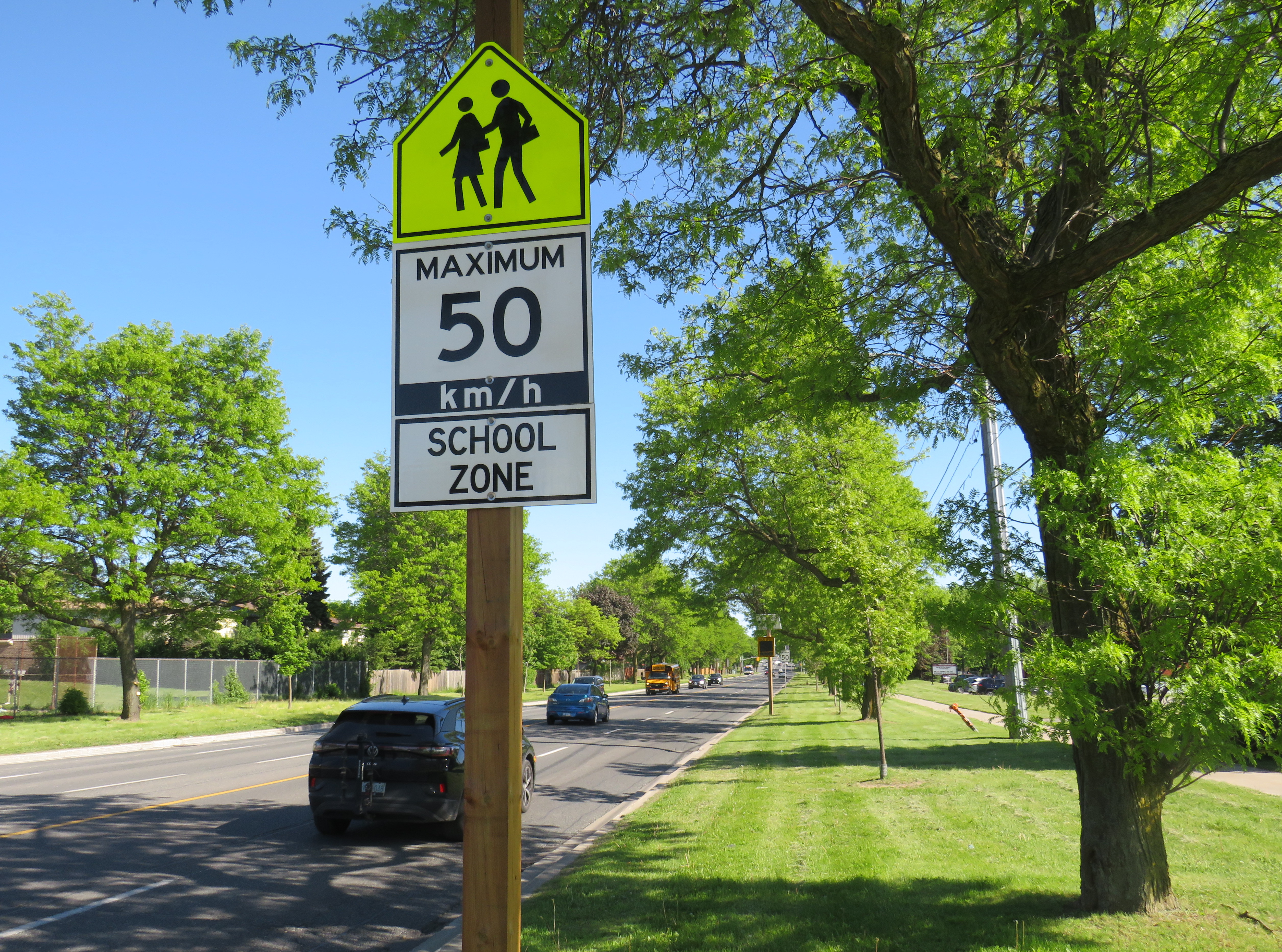
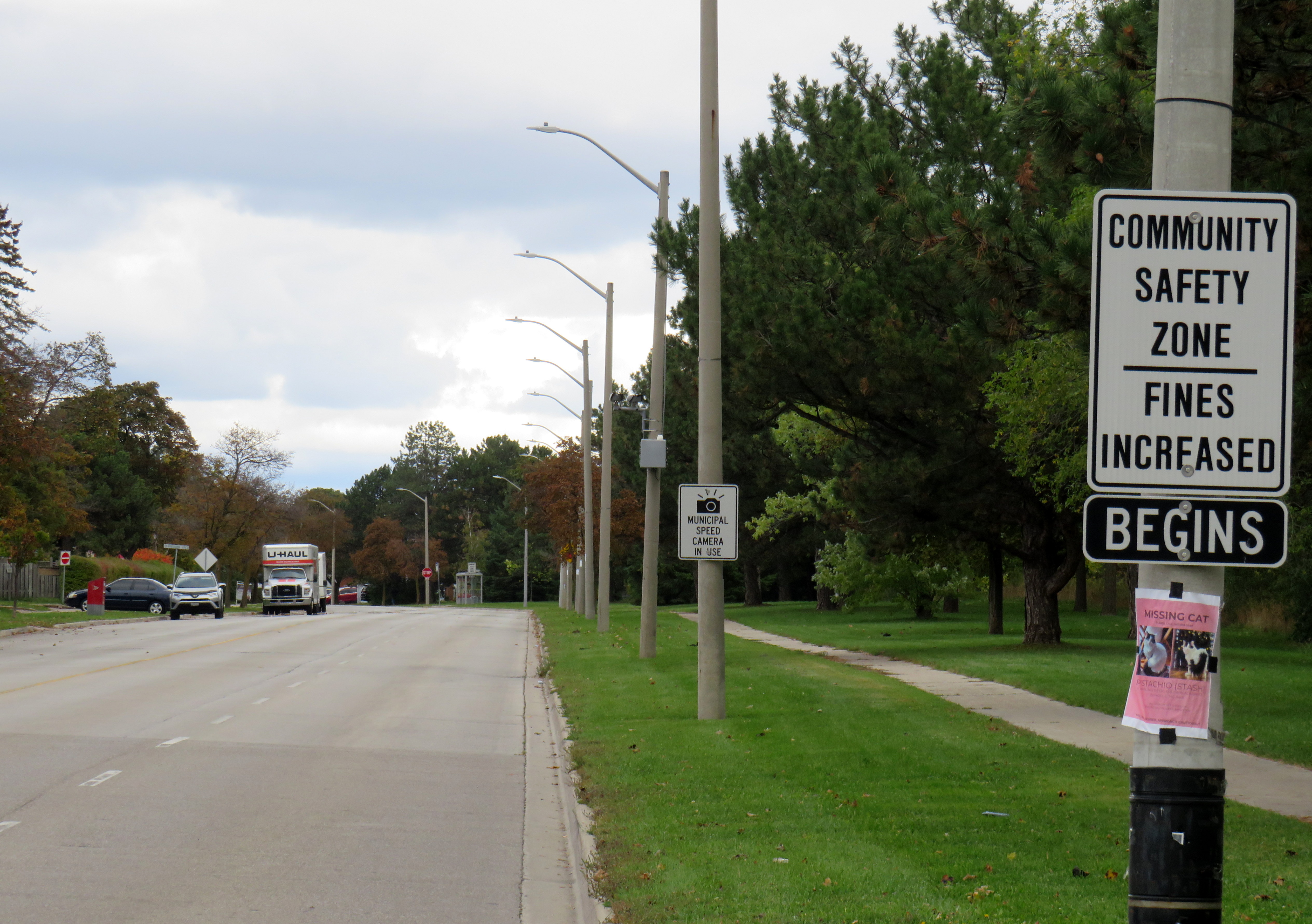
A gigantic school zone speed limit sign on McCowan Road in Scarborough
Months after Doug Ford’s provincial government banned the use of municipal speed enforcement cameras, calling it a “cash grab,” new supersized school speed zone signs are going up across the province. The first ones I encountered are on McCowan Road in Scarborough, near my spouse’s family home.
The signs, placed near St. Ignatius of Loyola Catholic School south of Finch Avenue, are gigantic: nearly 2.5 metres tall, mounted over three metres above the ground, affixed to an extra large wooden pole as the new signs were too big for the standard metal poles used for that purpose. The province delivered 80 signs to the City of Toronto, but with four signs per school zone (two mounted in each direction including advance warning signs), that meant only 20 schools would get these new totems.
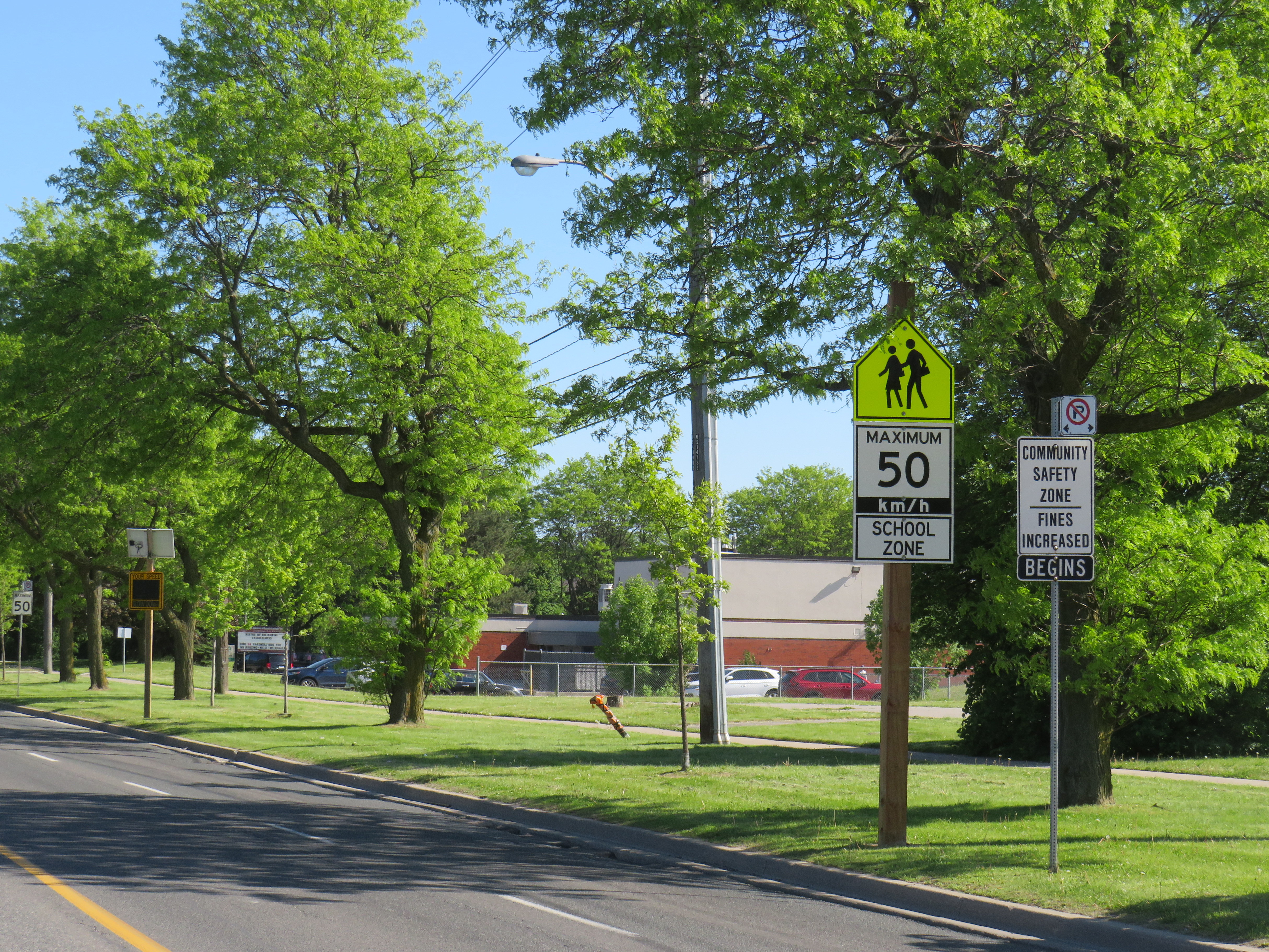
The new supersized school zone sign next to an older “community safety zone” sign, affixed to a standard metal sign pole
Before the pro-driver legislation was enacted on November 14, 2025, there was a speed camera placed on McCowan Road adjacent to the elementary school, one of 150 located in the City of Toronto. Under provincial law, municipal speed cameras were only allowed to be installed in specific designated safety zones, namely roadways adjacent to schools, parks, or seniors’ residences, and had to be accompanied with advisory signage.
Between April 2024, when the camera was activated, and July 2025, when the camera was destroyed (one of many vandalized that year), over 19,000 speeding motorists were captured by the photo camera travelling at least 11 km/h over the posted speed limit. This was despite the existing maximum speed, school zone, community safety zone, and municipal speed camera signs on this stretch of road.
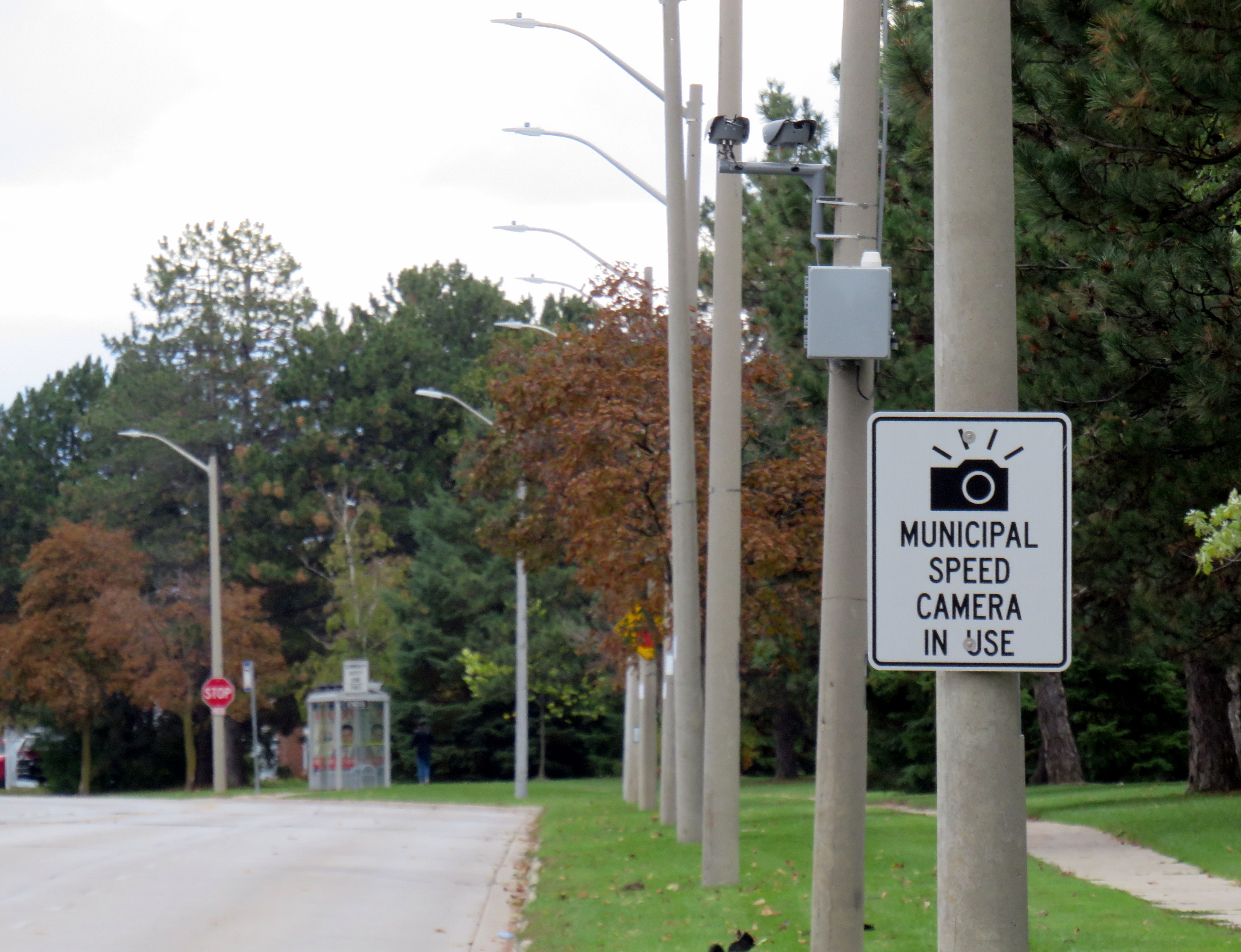
Sign warning of a municipal speed camera in Brampton in October 2025
Despite the high number of infractions, the cameras were doing their job; a job that the Toronto Police isn’t motivated — or able — to do. As seasoned municipal watcher Matt Elliot points out, for period between January 1, 2025 through November 14, 2025 (when camera enforcement was forced to end), 628,165 speeding tickets were issued through the automated speed enforcement program. Toronto Police’s “Vision Zero” traffic unit issued just 14,500 tickets.
New city report notes the Toronto Police Vision Zero Enforcement Team handed out about 14,500 speeding tickets in 2025. Might sound like a lot, but well, compare and contrast.
Despite all those tickets issued, the cameras were especially effective at reducing speeding in school zones. A 2025 Toronto Metropolitan University/SickKids Hospital study found that speed enforcement cameras reduced speeding by 45 per cent and reduced speeds by most drivers by more than 10 km/h.
Active police enforcement remains a valuable tool because officers can lay charges that automatic speed cameras can not catch, including distracted, impaired, and dangerous driving. But policing has a dark history of racial profiling and has a pro-motorist “windshield bias,” while speed enforcement and red light cameras do not discriminate.
Furthermore, North American roads are designed for excessive speed and not for the safety of vulnerable road users. We rely on signs to advise motorists of how we expect them to drive, rather than road design that requires attentive and slower driving. Speed cameras were a useful stopgap that worked a lot better than signage.
So, the new supersized signs going up are not a solution to unsafe driving: they are just another mere indication that children, seniors, and all pedestrians and cyclists don’t really matter, especially to politicians like Doug Ford.
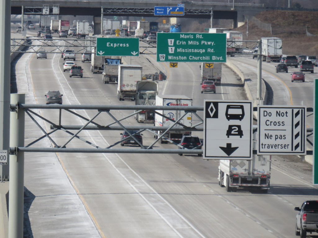
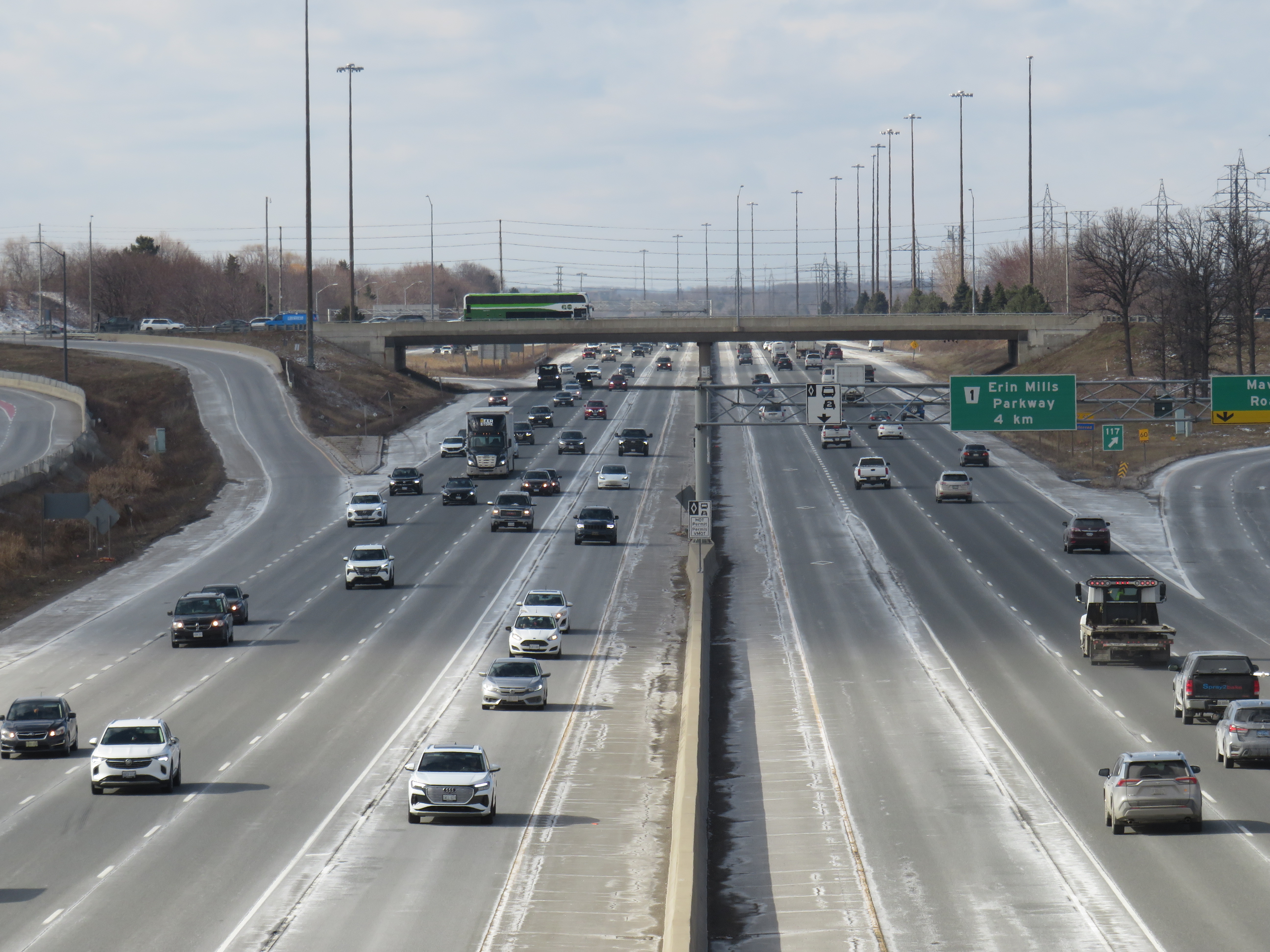
Highway 403 in Mississauga, with HOV lanes in the centre
In the last year, making the occasional car trip to visit family in Northeastern Ontario or just to get out of the city for a day or two, I kept wondering what the point of those new high occupancy vehicle (HOV) lanes were on the Queen Elizabeth Way, Highway 400, or Highway 401. At first, they seemed like a real time saver for anyone riding on a transit bus or driving with a few family members, friends, or carpool colleagues in the car. As time went on, with new exceptions, minimal or no police enforcement, and increasingly aggressive driving post-pandemic, one is left wondering why the province even bothers adding them to more highways.
Now, amongst a flood of moves and musings by our oft-Trumpian premier, it appears that the province has given up on even the veneer of sustainability with these highway widenings throughout the Greater Golden Horseshoe and Ottawa regions. On Tuesday, March 17 — St. Patrick’s Day — Transportation Minister Prabmeet Sarkaria announced a proposed regulatory amendment that would allow all cars and light trucks in the HOV lanes, during off-peak periods. The change would “help keep drivers moving across the province, so they can spend less time in traffic and more time with their families and friends.”
This announcement is part of a stream of messages from Doug Ford and his government clearly seeking the attention of the news media and the public. The week prior, Ford was talking about expanding the Toronto Island airport, even seizing control of the City of Toronto’s interest to ensure that jets could land on the waterfront. Before that, Ford mused about a new convention centre built on Lake Ontario near Exhibition Place. This week, Ford was on a law-and-order kick, attacking a fair and impartial judiciary, promoting the idea of “Bail TV,” and praising a homeowner that shot an intruder during a home invasion. Maybe this is to distract from scandal and a new proposed law to shield the premier, ministers, and staff from journalists using freedom of information requests to keep the government accountable.
The legislative assembly will finally reconvene next week, starting Monday, March 23, after a 14-week break.
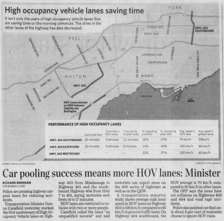
The first HOV lanes were introduced on Highway 403 through Mississauga and on Highway 404 southbound from Highway 7 to Highway 401/Don Valley Parkway in 2005. A year later, the HOV lanes were touted as an “unqualified success,” with the minister of transportation at the time, Liberal Donna Cansfield, promising more reserved lanes to follow, with the QEW through Oakville and Burlington to be the next implementation. With the Ontario Provincial Police (OPP) conducting active enforcement on those two sections, they found that only 5 percent of motorists in the HOV lanes were violating the law.
GO Transit was an especially keen user of the new HOV lanes. In 2005, only the Lakeshore Line had regular off-peak train service, and buses filled in the gaps in between. The 404 lanes saved valuable minutes for buses on the 70/71 Stouffville Line route between Union Station and Markham; the City of Toronto designated sections of the inner paved median on the DVP as well for GO buses that could be used to bypass traffic congestion.
Clip from the Toronto Star on Thursday, Dec 14, 2006
At the time, the HOV lanes saved carpoolers and transit riders up to 17 minutes on the initial segments on Highways 403 and 404. The additional capacity created with the new lane (no existing lanes were to be converted to HOV-only under provincial policy) also led to time savings for all drivers, at least in the short term. Increased traffic caused by suburban growth and induced demand eventually negated those time savings for general traffic.
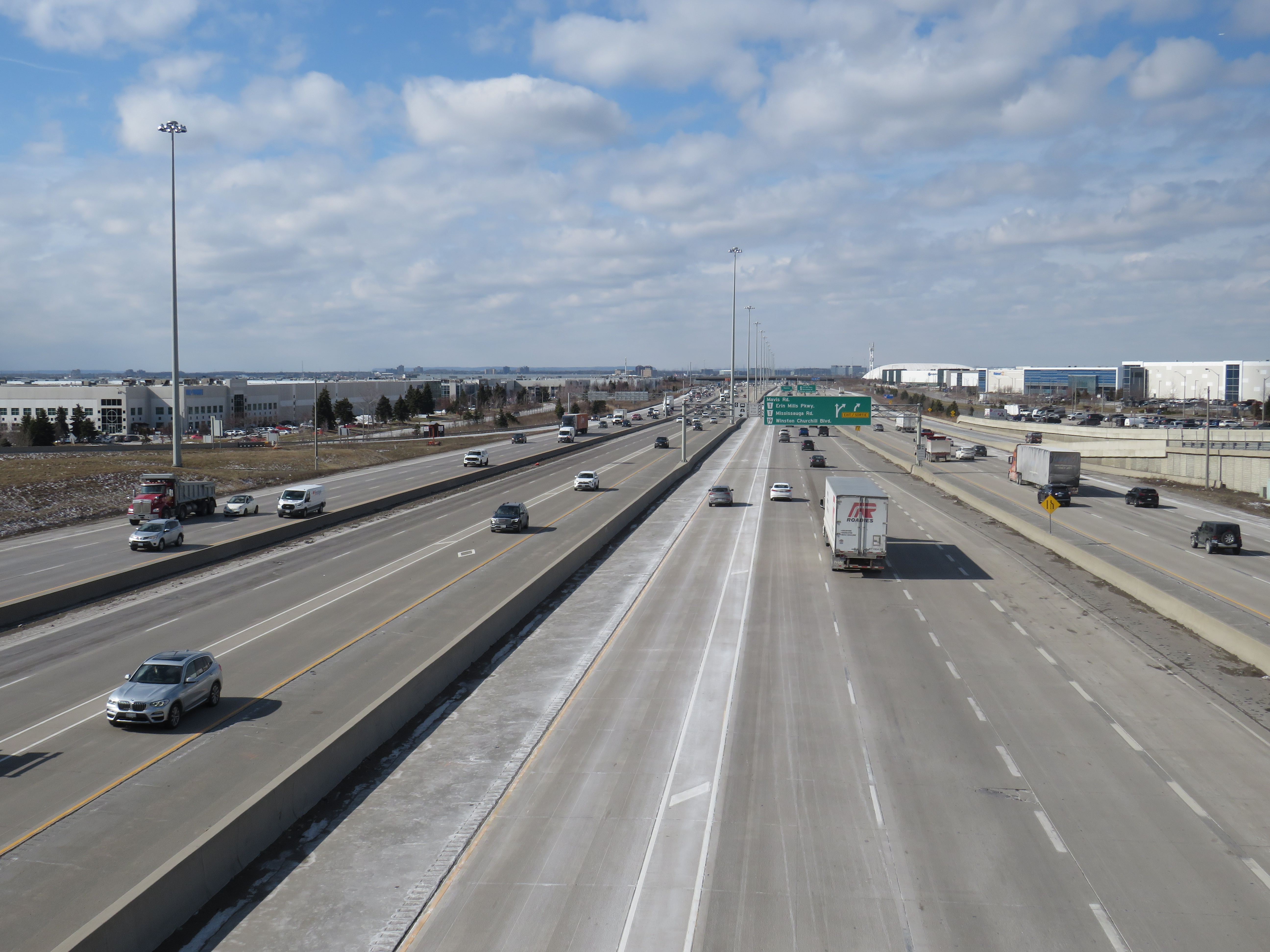
HOV lanes were included in more highway expansion projects. The QEW HOV lanes through Oakville and Burlington were added in 2011. Lanes on Highways 400, 410, and 427 and Highway 417 in Ottawa followed, and when Highway 401’s express/collector system was expanded through western Mississauga and Milton, HOV lanes were part of that too.
“One more lane should do it,” Highway 401 in Mississauga, with HOV lanes in the middle of a recently widened highway
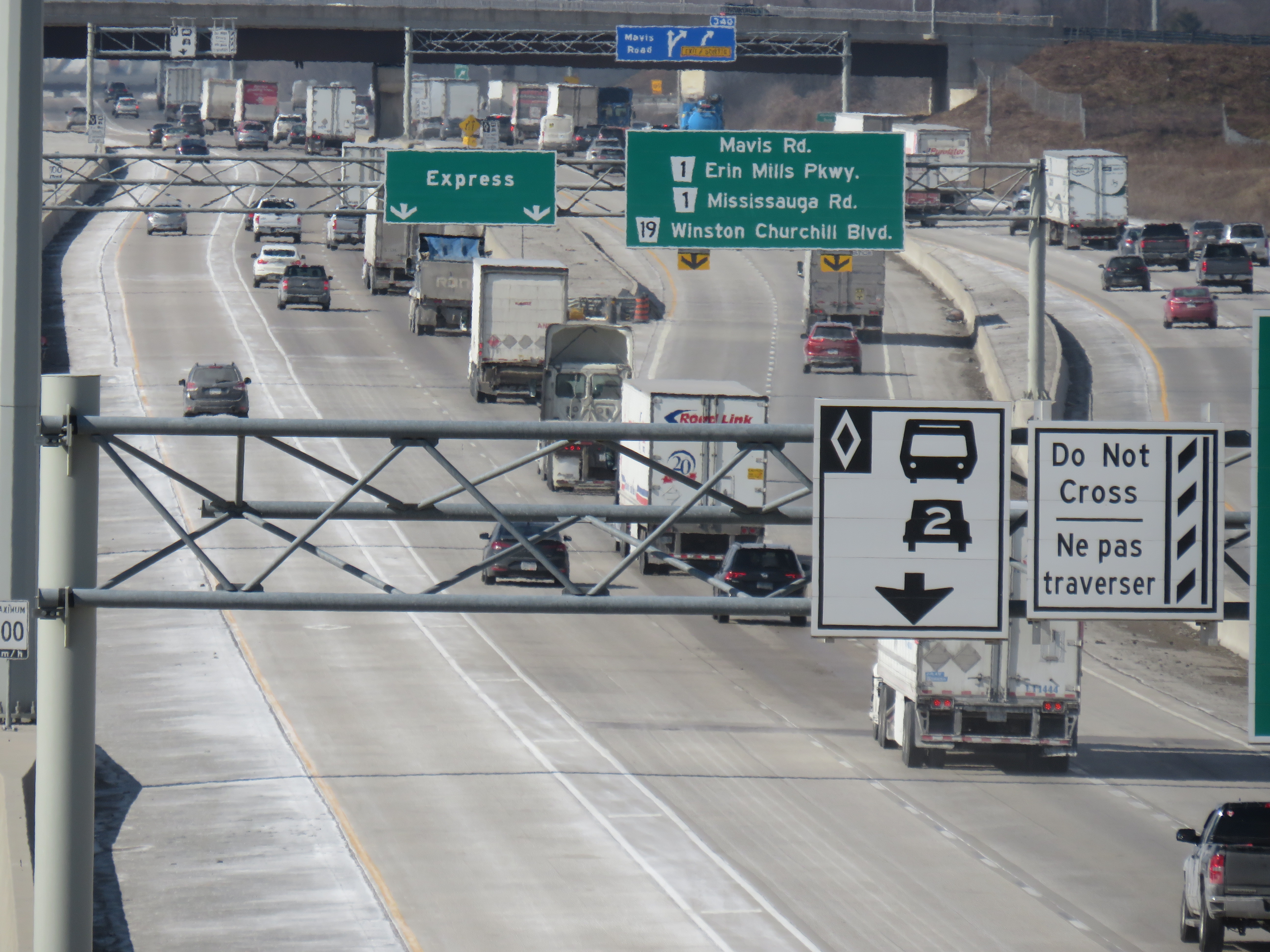
Regulations on the use of HOV lanes were relaxed over the years too. Motorcyclists were permitted, as were any vehicle with a “green” license plate (available to any battery-electric or plug-in hybrid car, SUV, or light truck). HOT permits were also added, for anyone willing to pay and enter a lottery for the right to use the lanes while driving alone. Taxis and airport limos were also allowed, even when not carrying a passenger.
Poor driving habits, which seemed to have gotten worse since the COVID-19 pandemic, have made a mockery of the initial intentions of the HOV lanes. Without enforcement, the HOV lanes are essentially treated by some drivers as fast lanes, with sudden swerving in and out despite double solid lines and “Do Not Cross” signs consistently posted along the highway, intended to reduce weaving. Solo drivers regularly use the lanes without consequence to get around slower drivers or trucks.
Despite “Do Not Cross” signs, and a double solid line between the HOV lane and general traffic, this regulation is regularly ignored
For now, we do not know what “off-peak hours” would mean when the provincial government finally legalizes another bit of the selfish and aggressive driving behaviour the rest of us have sadly gotten accustomed to. The QEW is frequently jammed most weekends between May and October, when families and tourists travel between Toronto, Hamilton, and Niagara. Highway 400 is notorious on Friday evenings and Sunday afternoons during Cottage Country commutes.
This is yet another motorist-friendly move by this government eager to hold onto seats in suburban ridings and please its wealthy backers, along with permanent gas tax breaks, abandonment of license plate renewal fees, the prohibition on speed enforcement cameras, and the construction of destructive new highways like the 413. But at least this latest move is an acknowledgement of something I have felt for years about the HOV lanes in Ontario: a simple greenwashing of highway expansion, making us feel better about laying more concrete and asphalt.
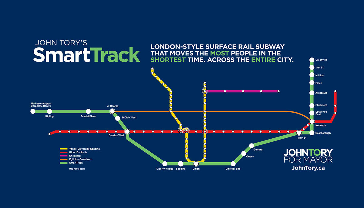
Map of John Tory’s SmartTrack proposal, his signature campaign plank from the 2014 municipal election
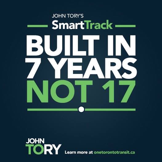
SmartTrack, the transit plan championed by former mayor John Tory in 2014, is the election promise that will never fully die, even if it was diminished from the promise of a brand-new 53-kilometre transit relief project to just a few new stations on existing GO Transit rail corridors. SmartTrack, as initially pitched, would have utilized existing rail and highway corridors to quickly build an express rapid transit line that would provide much-needed relief to the Yonge Subway line, foster development of the East Don Lands (former site of an Unilever soap factory), and connect downtown with employment lands in Markham and Mississauga. According to campaign materials, SmartTrack would have been built in just seven years.
Eleven years later, that relief is coming, but through other forms: the now under-construction Ontario Line, expansion of the Bloor-Yonge Subway station, and slow subway ridership recovery after the COVID-19 pandemic restrictions in 2020-2021. The Mount Dennis-Airport Corporate Centre section, nearly impossible to build as a continuous passenger rail line, is now being built as a tunneled extension of the Eglinton-Crosstown LRT.
Over a decade later, the legacy of SmartTrack, along with other major changes for the GO Transit Kitchener Line, will affect both GO operations and UP Express, Toronto’s airport rail link, which will be asked to do more despite existing constraints. Without rigorous planning, transparency from Metrolinx, and stakeholder input, the potential of Toronto’s northwest corridor as a high-quality local and regional transit project is in doubt. With significant investment and proper planning, the Kitchener Line could serve as a shining example of how to get things right.
The diminished legacy of SmartTrack
It’s possible that three “SmartTrack” stations might be completed in 17 years
The idea of a “London-style surface rail subway” for Toronto was, and remains, a laudable goal for our existing GO Transit rail corridors; this was the concept behind the GO Expansion project touted just a few years ago that would truly transform the system into a high-quality urban rail network. It would not only serve suburban municipalities like Markham, Brampton, and Mississauga, but also improve travel times to the inner suburbs such as Agincourt and Rexdale.
What SmartTrack got wrong was relying on a flawed report that had very specific aims, poor public buy-in, and an arrogant, yet ineffectual proponent who nevertheless managed to win re-election, twice. (He might run again in 2026.) It didn’t help that SmartTrack was a municipal idea that was not coordinated with the provincial planning process; it never really got off the ground, even if municipal planning staff were charged with implementing the proposal. Ideally, the city should have just pushed hard to advance GO expansion on multiple corridors and for fare integration with the TTC.
Despite years of inaction, five SmartTrack stations remain on the books, to be funded largely by the City of Toronto. This was a curious arrangement as the provincial government has taken responsibility for the costs of all other GO Transit expansion projects, along with subway and LRT extensions. The five stations the city committed to were:
East Harbour (Lakeshore East/Stouffville, with a connection with the Ontario Line)
Finch-Kennedy (Stouffville Line) and
Bloor-Lansdowne (Barrie Line, not on the old SmartTrack map)
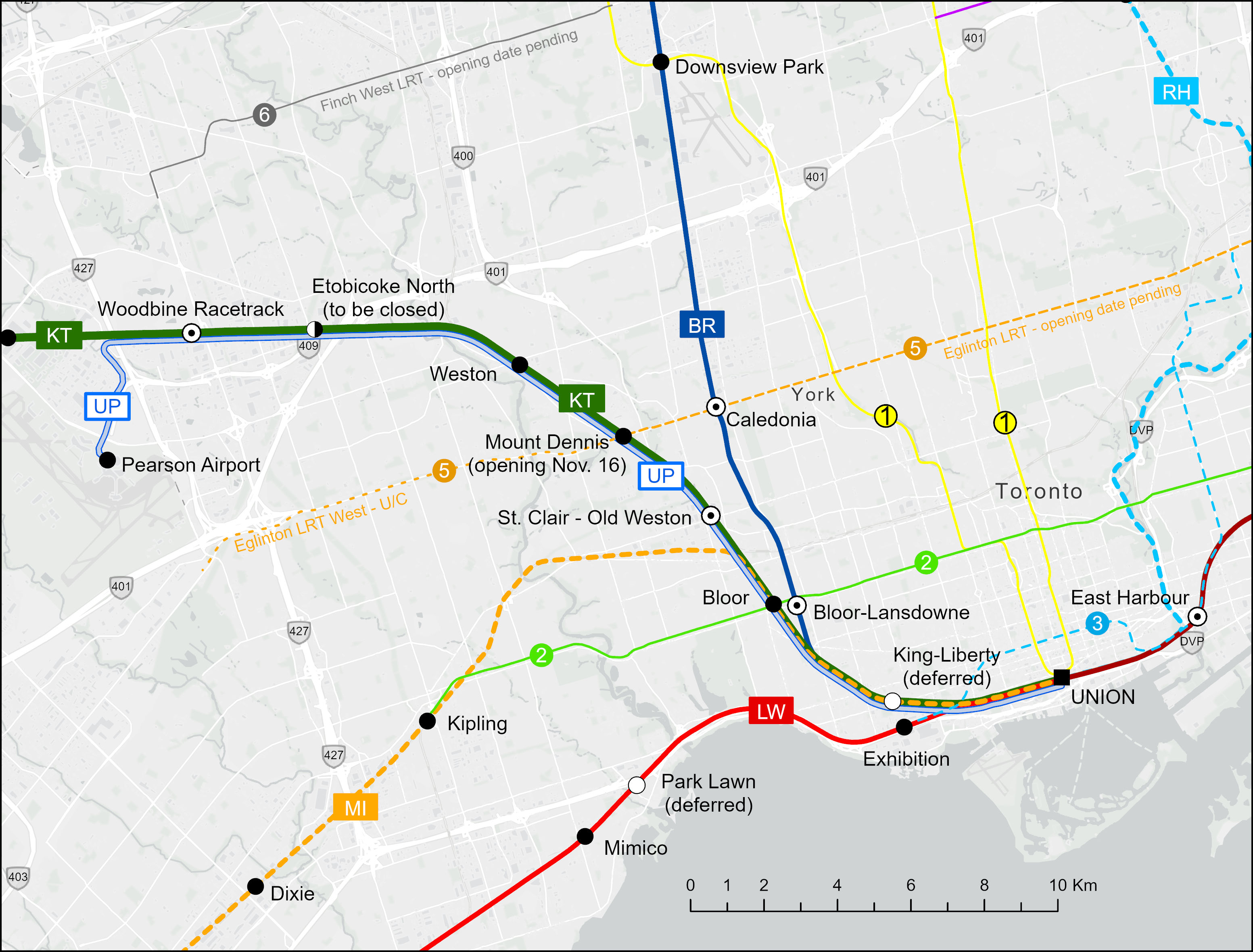
The King-Liberty and St. Clair-Old Weston stations, present in the original SmartTrack map, are on the inner portion of the busy Kitchener Line, which now hosts two-way, all-day service between Union and Bramalea Stations, as frequent as every 30 minutes weekdays. This section of track, known as the Weston Subdivision, also hosts UP Express (UPX) trains, which run every 15 minutes between Union and Pearson Airport, with stops at Bloor and Weston stations. It will also stop at Mount Dennis when that station opens in mid-November, connecting with the Crosstown LRT when that opens, likely in early 2026.
Bloor-Lansdowne is a curious “SmartTrack” legacy station, as it was not on the original proposed route. Located just east of Bloor GO Station on the Kitchener Line, the two-platform station would serve Barrie Line trains, with a walking connection to the TTC’s Lansdowne Station two blocks to the east. (See my supplementary post highlighting this transfer.) Unlike King-Liberty and Finch-Kennedy stations, Bloor-Lansdowne is going ahead as construction had already started in 2024.
Bloor-Lansdowne Station is two blocks west of Lansdowne Station and a 7-10 minute walk to the subway, which runs north of Bloor Street. From 2023 City of Toronto report.
Bloor-Lansdowne probably should not have been advanced, especially when King-Liberty or even Finch-Kennedy would be more useful new stations.
St. Clair-Old Weston Station will still go ahead, even though pedestrian access and transfers to local transit lines will be less than ideal. Rail platforms will be accessed from Union Street, not directly from St. Clair Avenue, Keele Street, or Old Weston Road. Though TTC buses could be diverted to the planned bus loop, transfers to streetcars on the 512 St. Clair line will be awkward and unattractive to riders. (See my supplementary post that describes the challenges in more detail.)
Map of inner portion of GO Kitchener Line, UP Express, and connecting rapid transit lines
Woodbine GO Station (not to be confused with Woodbine subway station on Line 2), located on the Woodbine Racetrack lands, is now under construction. When complete, it will replace Etobicoke North Station, which only has one platform and cannot be easily expanded for a four-track mainline. There is the potential for a short extension of the soon-to-open Line 6 Finch West LRT to Woodbine from Humber College. Woodbine Station would serve both GO trains and UPX, allowing passengers from Kitchener-Waterloo and Guelph to make an easy transfer to Pearson Airport. Woodbine would also be a logical transfer point between local GO trains to Bramalea and Mount Pleasant and express GO trains to Guelph and Kitchener.
With these decisions in mind, the challenge now will be figuring out how to serve the new Kitchener Line stations.
What is UP Express for, anyway?
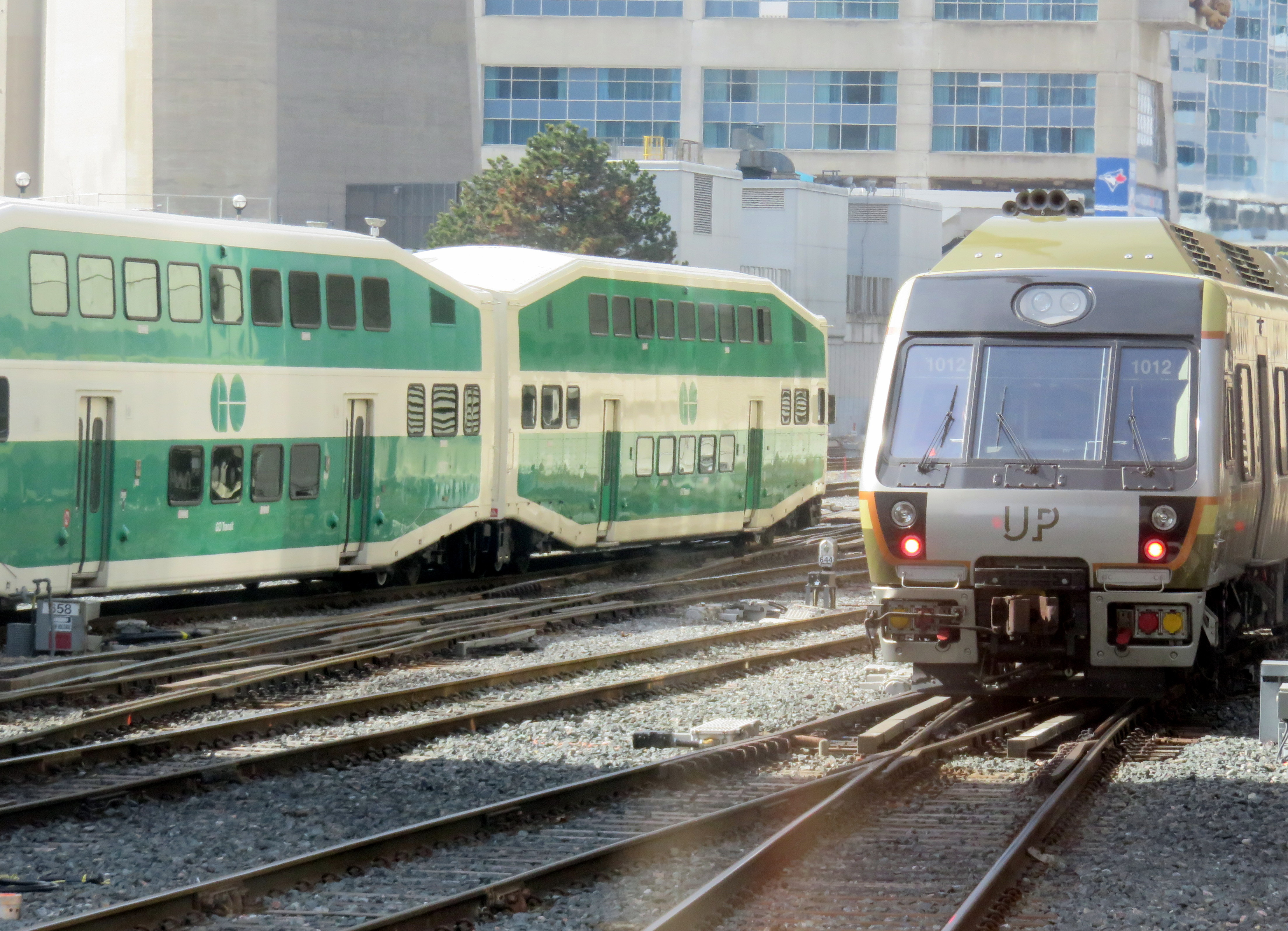
UP Express and GO trains near Union Station
UP Express, for all its faults, is an example of what urban regional rail looks like. Trains are frequent – every 15 minutes – seven days a week, from early in the morning to late at night, with the last train leaving Union at 1:00 AM. Stations feature high-level boarding, ideal for quick and easy boarding, especially for those passengers with luggage, strollers, or using mobility devices. The only other comparable example in North America is Denver’s A-Line train, an electrified service which also makes multiple stop between the downtown core and the city’s international airport.
A 15-minute frequency is important as it is commonly cited as the minimum level of service for a “get up and go” level of transit convenience and attractiveness. Right now, the Kitchener Corridor has a base hourly service between Union and Bramalea seven days a week, with additional peak-direction express trains and 30 minute service during much of the weekday service period.
Because of its reliable and frequent service and affordable fares, UPX has become a victim of its own success, with many riders travelling between Union, Bloor, and Weston, rather than going all the way to and from the airport. This problem was especially evident when riders were left stranded after the end of game seven of the 2025 World Series. The last train left Union station completely full, not long after the game finished in extra innings.
Fares for riding UPX are quite reasonable. When UP Express was first launched, a one-way fare to the airport was $27.50. In 2016, that adult fare dropped to $12.00, today it is $12.35. Adult fares paid with a Presto card are discounted by $3.10. An adult fare between Weston and Union is just over $5. However, UPX despite being owned and operated by Metrolinx, has no fare integration with GO Transit, and it is not part of the provincial One Fare program that permits free transfers between GO, the TTC and other GTHA transit agencies. This is likely intended to minimize overcrowding, even though it limits the utility of UPX.
Another constraint is the UPX fleet and station size. All UPX stations are designed for three-car trains, as the service was designed to be a premium airport rail link, not an urban transit service. There are just 18 Nippon Sharyo DMU rail cars available for service, assembled into four 3-car trains, and two 2-car trains. The interior design is set up for a premium airport service, with rows of forward/backward facing individual seats and lots of luggage space.
These challenges will be exasperated with the addition of new stations at Mount Dennis and St. Clair-Old Weston. Furthermore, Metrolinx has requested that City of Toronto modify plans for the St. Clair-Old Weston (or SCOW) station to be UPX-only. According to an October 21, 2025 report to Council’s Executive Committee, “Metrolinx has indicated that this service change is required to maintain the 15-minute (or better) service frequency commitment made by Metrolinx for the SmartTrack Program, which can no longer be maintained by GO service.”
Despite Metrolinx building a fourth track on the Weston Subdivision that will extend to Pearson Junction (where the UPX tracks diverge towards the airport) from the Union Station Rail Corridor (hence the closures of the West Toronto Rail Path), it seems that it can not commit to operating 15-minute service for both GO and UPX service, which seems like a ridiculous state of affairs when this is common practice in Europe and Asia. This goes against the whole concept of GO Expansion, which promised to deliver fast, frequent, integrated GO service to most of its corridors.
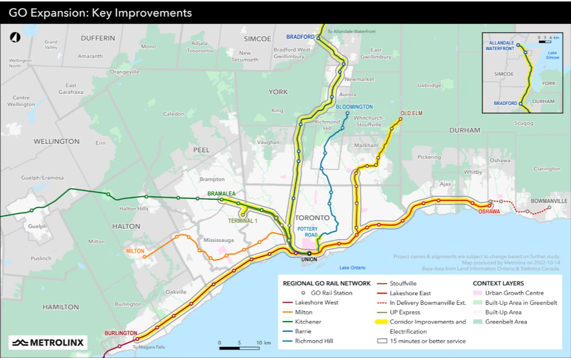
2022 Metrolinx map depicting corridor improvements, electrification, and 15-minute service for the inner portions of the Lakeshore West, Lakeshore East, Stouffville, Barrie, and Kitchener lines.2022 Metrolinx map showing the Kitchener Corridor with “corridor improvements and electrification” for the Toronto-Bramalea inner portion of the line, along with other construction projects between Bramalea and Kitchener.
Perhaps Metrolinx’s inability to conceive of GO becoming more than just a suburban commuter railway is why Deutsche Bahn pulled out of its contract with Metrolinx early in 2025. Since The Trillium’s June 2025 investigation, there has been little said about the collapse of GO Expansion. Communications and transparency have not been Metrolinx’s strong suit, especially in the last few years as Doug Ford’s PC government has tightened its control on all government communications.
So, if St. Clair-Old Weston is served only by UP Express, it will have to be completely rethought. It will not be able to offer an exclusive, 25-minute ride between Terminal 1 and Pearson Airport. That in itself is fine. A train taking 30 minutes to travel the same distance, with a few additional stops will work, provided that the trains have the capacity to serve both airport passengers and urban transit riders. Stations should be six cars long, then, with a new Union Station terminal, ideally under the main trainshed for easy connections to TTC, GO, and VIA Rail. GO Transit trains would then focus on suburban and regional travel between Toronto, Malton, Brampton, Guelph, and Kitchener, skipping most existing stops in the City of Toronto, part from Woodbine and perhaps Bloor.
But Metrolinx, the City, and the Province need to express their intentions openly and clearly so that we, the passengers and taxpayers, know what will happen, and that we will get the best transit possible. Let’s be smart about this.
Dearbourne Boulevard, a four-lane collector street designated a community safety zone
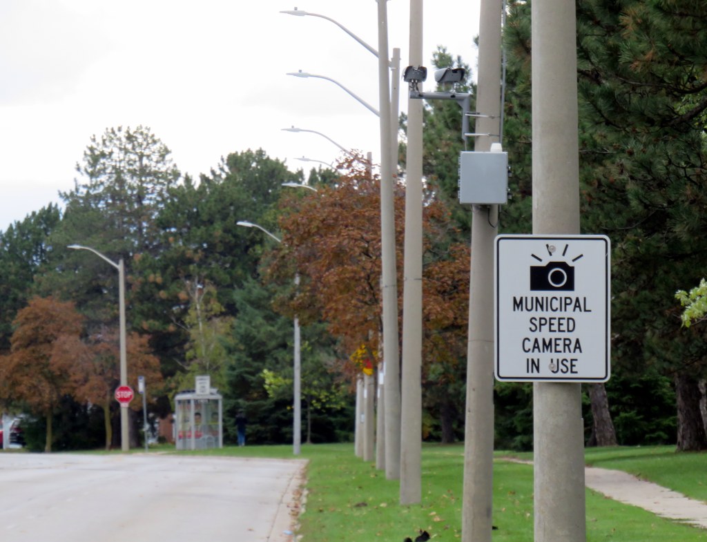
Last week, while visiting Brampton, I came across one of the hundreds municipal speed enforcement cameras that Premier Doug Ford’s government wants to rip out across the province. The camera, on a four-lane collector street in Bramalea, is in a residential area, adjacent to several parks, including a pathway to a local public school, in an area designated a community safety zone. This is precisely the type of place that the government intended speed enforcement cameras would go when they were permitted under provincial legislation in 2019.
In a September 2025 government press release touting the move as “protecting taxpayers,” Ford, whose government was in power when these cameras were permitted, claimed that the program became “a cash grab;” supporting quotes included those from former Liberal leader and current Vaughan mayor Steven Del Duca, a representative of the province’s municipal police unions, and a spokesperson from the right-wing Canadian Taxpayers Federation.
If only there was a simple, effective way for taxpayers to avoid the so-called “cash grab.”
It was interesting who was not quoted in that press release, including doctors, educators, safety advocates, and even police brass. Ontario police chiefs support automated speed enforcement. It is also worth noting most municipalities support the cameras; Vaughan is one of only a few municipalities that recently rejected the road safety program; Del Duca was joined by just two other conservative-leaning mayors.
Of course, the arguments against the cameras, which in Toronto, were repeatedly vandalized or stolen, never held water. There were no tickets mailed out to drivers going just a few kilometres over the limit. Furthermore, speed enforcement was never a “cash grab” as the fines collected went to pay for the administration of the program, to “Vision Zero” works, such as the installation of speed cushions and improved pedestrian crossings, and to the province, which the collects the victim surcharges added to every Highway Traffic Act fine. The City of Brampton found that not only were the cameras effective in reducing speeds, they had the support of a majority of its residents.
Municipal speed camera
That said, while visiting Dearbourne Boulevard, I realized that speed enforcement cameras on their own are not effective in creating safer streets.
Dearbourne Boulevard serves one of the oldest parts of Bramalea, established in the early 1960s as a self-contained satellite town, where residents were expected to drive to most destinations. After amalgamation into the City of Brampton, traffic increased and more transit became available. Nearby, several newer high-rise apartment buildings were built, walking distance to Bramalea GO Station. A bus route, 16 Dearbourne, runs along the street, connecting the neighbourhood with several shopping plazas, the GO Station, and the transit hub adjacent to Bramalea City Centre.
Despite having low traffic and serving a residential area (an industrial area is just to the south, but it is inaccessible from Dearbourne), it is still a wide four lane street. The only traffic signal is at Bramalea Road; there are two all-way stops at Delamere Drive and Dorchester Road. At the east end of Dearbourne, the T-intersection with Balmoral Drive is controlled only be a stop sign, with two long and gentle right turn slip lanes. The speed limit is 50 km/h, and there are no speed cushions, curb extensions, or even painted buffers to indicated that drivers should go slower. In October 2022, a pedestrian was struck and seriously injured at one of the two all-way stop intersections; the driver fled the scene.
Though to its credit, the City of Brampton has been improving many suburban streets and roads to reduce speeds and promote walking and cycling. Charolais Drive, Vodden Street, Central Park Boulevard, and Vodden Road saw traffic lanes replaced by new cycling lanes, with little pushback from residents. Dearbourne Boulevard was also slated for improvements in 2021-2022, but that work was not yet started.
Central Park Boulevard, Howden Boulevard, and Vodden Street were among several four-lane collector roads tamed with new cycling infrastructure in the last five years, creating a new through east-west cycle route
Now, it might be too late. Not only will the speed camera be prohibited under a bill being rushed through the provincial legislature (going around the consultation process where concerned citizens, advocates, or safety experts could depute to MPPs), but another omnibus bill was just introduced, which if passed, would prohibit all Ontario municipalities from removing general traffic lanes to install cycling infrastructure, or even transit lanes and on-street patios.
Given the provincial government’s increasing hostility to anything that inconveniences drivers, be it road tolls, vehicle license renewal fees, automated speed enforcement, or bike lanes, it leaves municipalities fewer options to protect their most vulnerable road users and promote sustainable and healthy transport options. Though Doug Ford claims that alternatives like flashing lights and more signs would do the trick, they do not do much to deter aggressive and dangerous drivers, unlikely to get caught.
For streets like Dearbourne Boulevard, there are a few options. Lowering the speed limit to 40 km/h should be a first step. The redundant outer two lanes could be converted to parking-only spaces, with curb extensions and bollards at intersections. The slip lanes at Balmoral Drive should be ripped out.
Roads designed in the 1960s and 1970s for traffic that never really materialized need to be rethought, with or without Queen’s Park’s support.
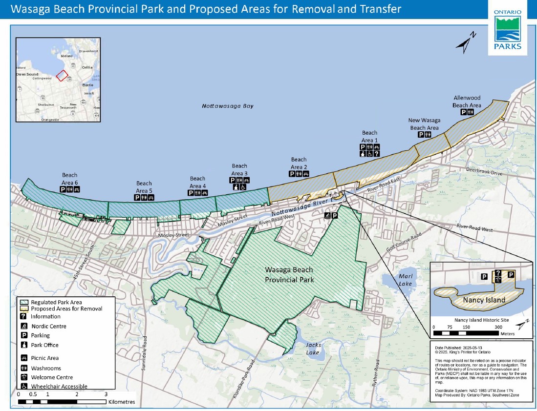
In late July, online news outlet PressProgress reported on the provincial government’s plans to divest itself of 60 percent of the beach areas of Wasaga Beach Provincial Park, transferring the waterfront lands to the Town of Wasaga Beach. This report raised a number of concerns, including environmental issues (the beach is an important habitat for the piping plover, an endangered species of shorebird which breeds on sandy shorelines), as well as continued public access to the world’s longest freshwater beach. By amending legislation to transfer these lands from provincial to local control without future votes in the legislature, future provincial park lands could also be sold off to municipalities or to the private sector.
Wasaga Beach Provincial Park and proposed areas for removal and transfer to the municipality
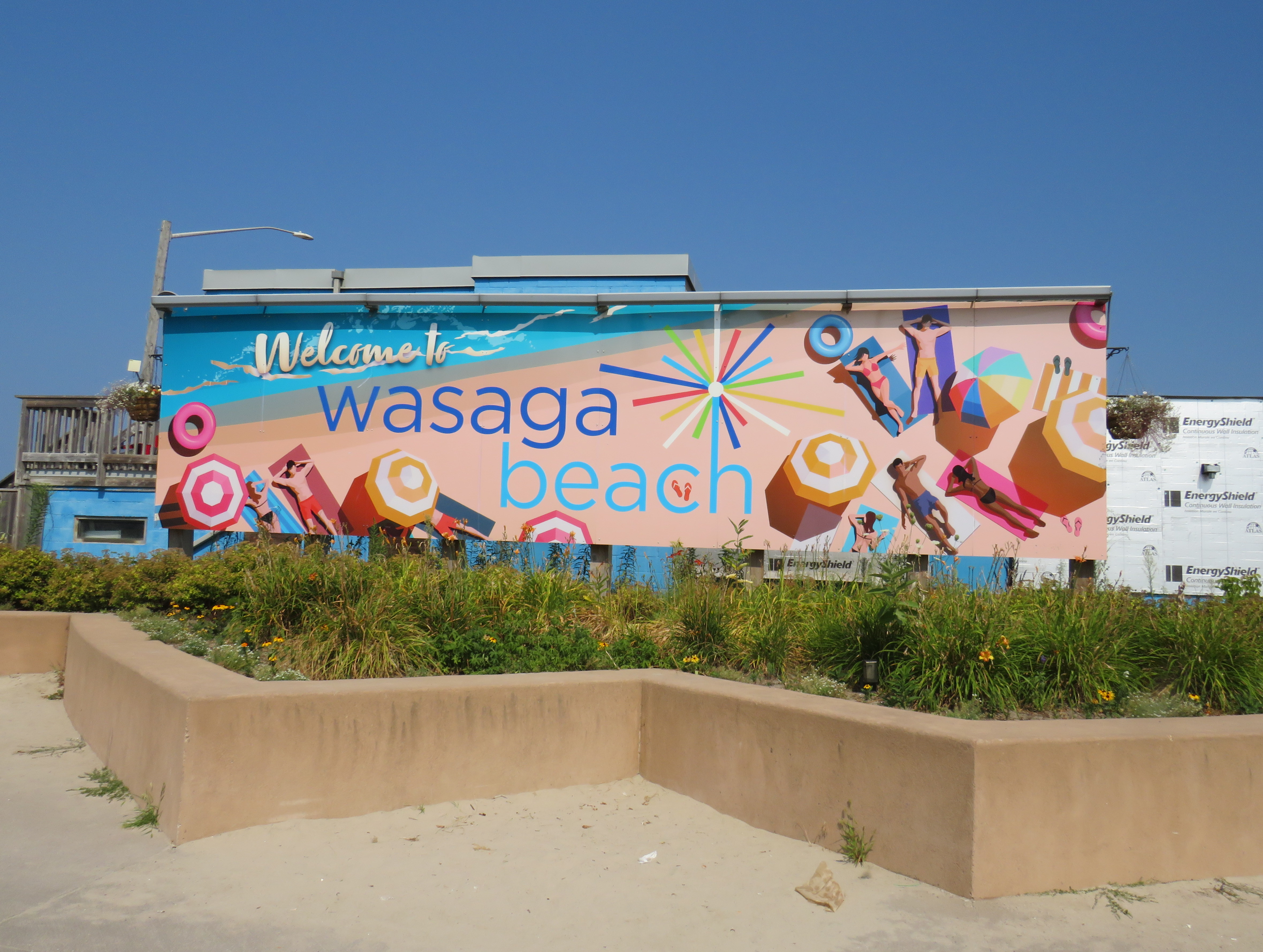
Sign touting provincial funding for Wasaga Beach’s beachfront redevelopment
Amending the Act to permit the divestment of protected lands is a bad precedent, though arguably it was already set by the privatization of much of Ontario Place for the troubled Therme spa development. The closed Ontario Science Centre grounds remain in limbo as well.
As Shawn Micallef recently pointed out in the Toronto Star, much of Ontario’s prime lakefronts are privatized or purposely made inaccessible to outside residents — not just the popular Muskoka Lakes, but also much of the Great Lakes shores, such as in Tiny Township near Midland. The big, popular, beach areas are worth preserving and expanding, not only to meet current demand, but also provide sustainable and affordable getaways for a growing population in Southern Ontario.
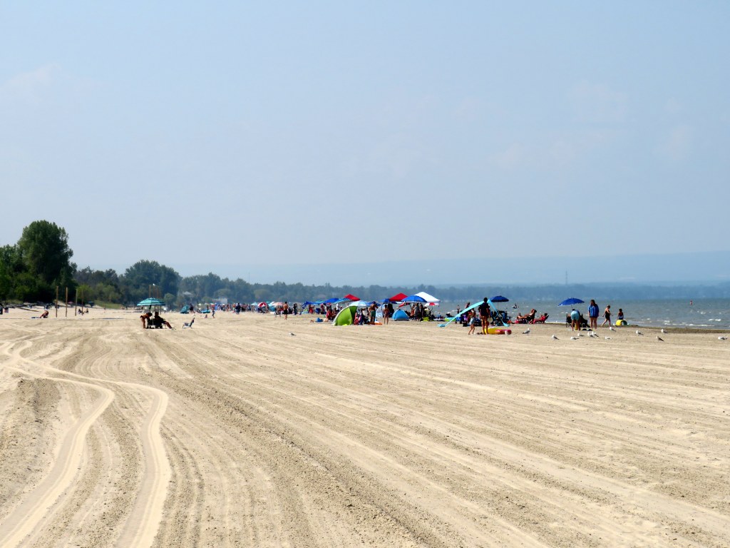
The beautiful sand at Wasaga Beach Provincial Park on Thursday, August 14
That demand for summer lake access brings up another challenge — how to get people to and from beach destinations. In Toronto, the lineups for the Island ferries are notorious in the summer. The compound where ferry-goers are forced to wait only adds to the inhospitable atmosphere, though temporary shade structures were added for 2025. The beach at Ontario Place, one of the cleanest on Lake Ontario, has been closed off for the controversial Therme spa construction.
For those living in Toronto’s suburbs, or anyone looking to avoid the downtown congestion, to get to a good beach will probably mean a road trip to somewhere like Wasaga Beach, Sauble Beach, Grand Bend, Port Dover, Long Point, or Prince Edward County. Many of these places are completely inaccessible without a car, or at best, have limited bus options. Furthermore, even where there is a transit link, the best beach areas are nowhere near where the bus or train makes its stops. Even though Brampton is a straight shot up Airport Road to Georgian Bay, driving is the only reasonable way to get to Wasaga Beach (as I will get into in the second half of this post).
Right now, Wasaga Beach and Collingwood – a four-season resort town – are connected to Toronto, Barrie, and elsewhere only by two-lane roads: Highway 26, Airport Road, and Sunnidale Road. These roads are often congested with both visitors and with regular traffic. Highway 400 up to Barrie is already being widened, but it too will face additional traffic from population growth in Simcoe County and additional leisure travel.
If Wasaga Beach goes ahead and develops transferred provincial parklands for more intensive economic development, it will have to contend with these transportation challenges. That will mean wider roads and new highways, improved transit links, or both.
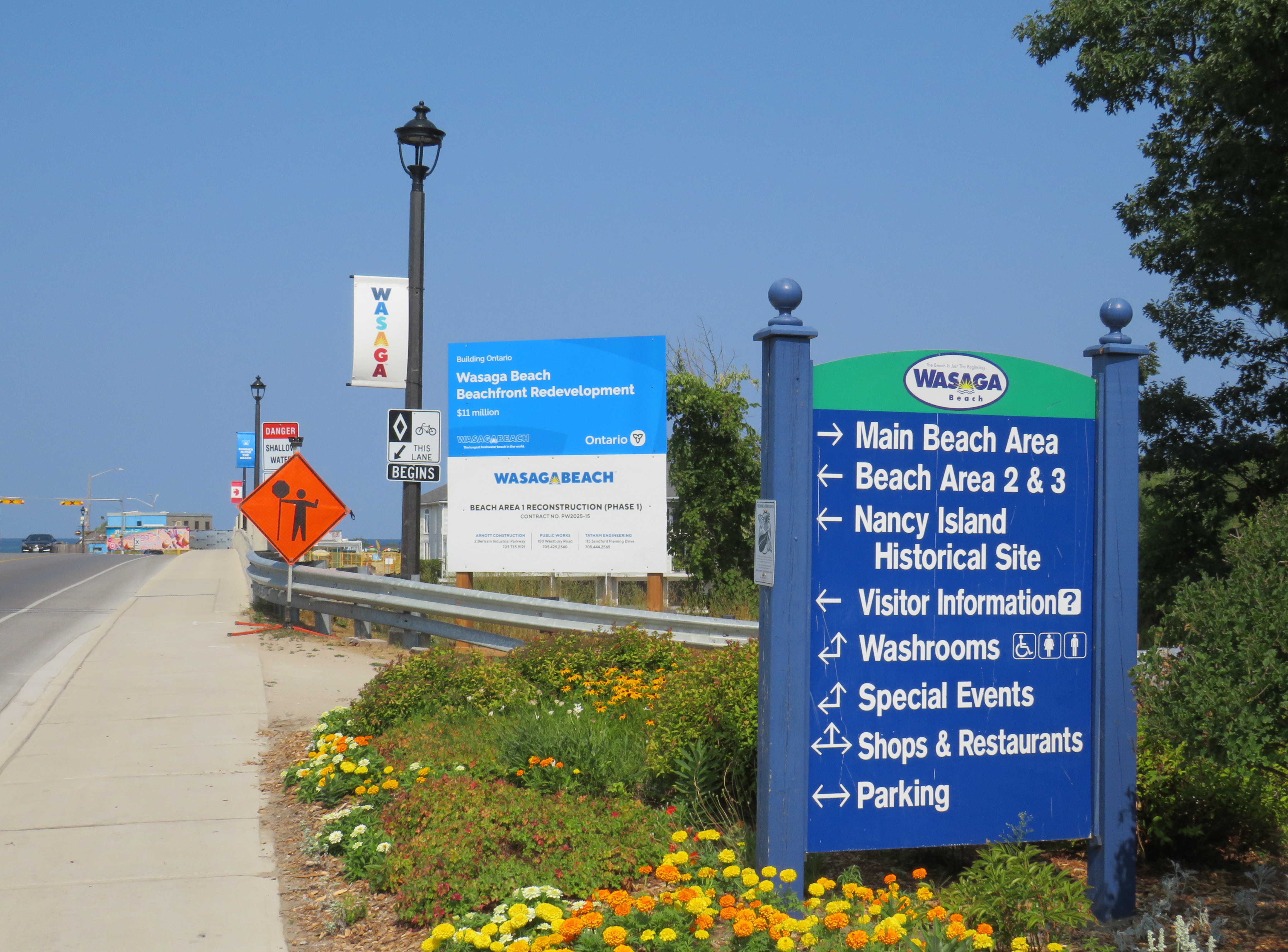
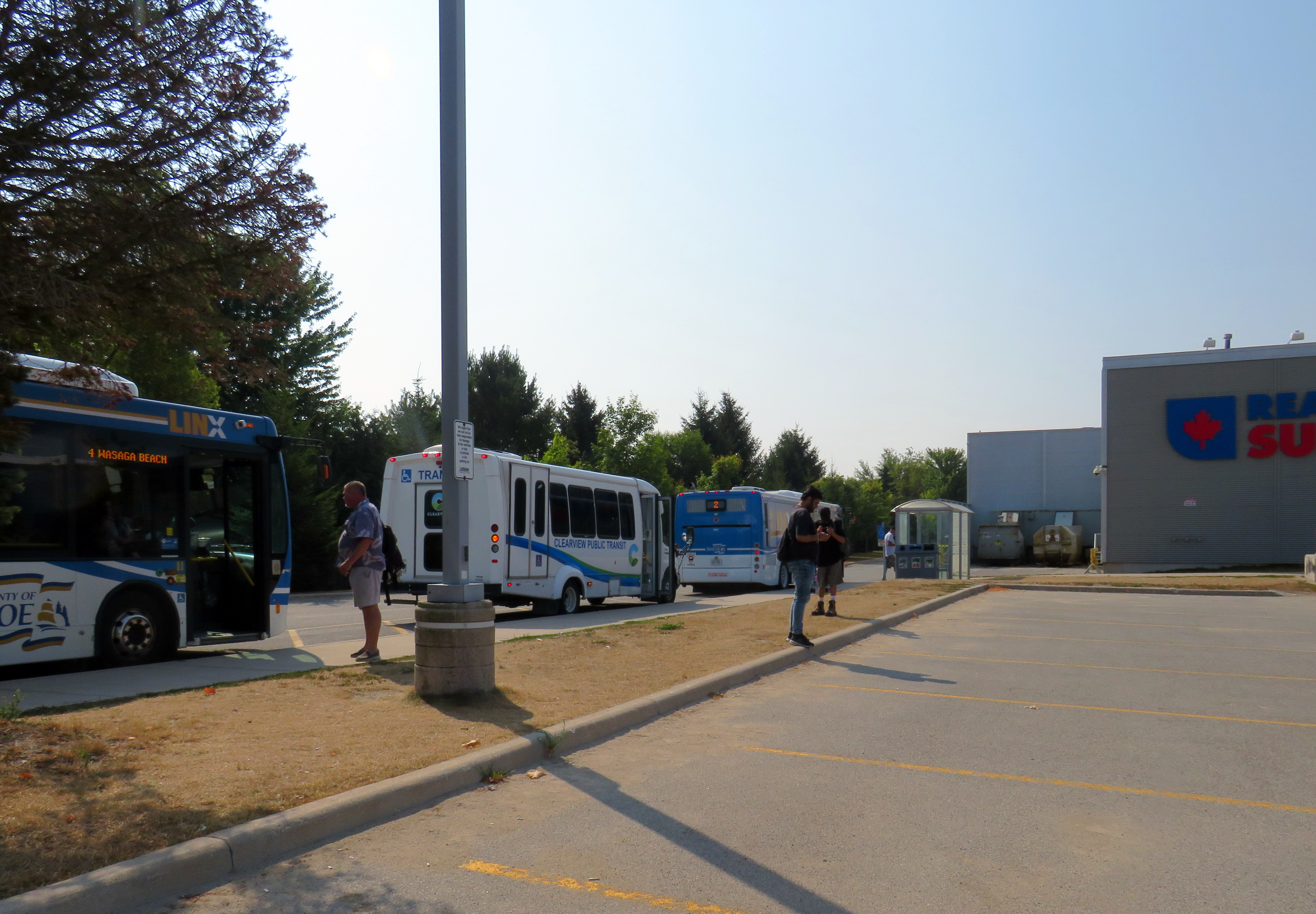
Local and regional buses behind a Loblaws superstore parking lot in Wasaga Beach
The way to Wasaga
There are currently two ways of getting to Wasaga Beach without a personal vehicle or a taxi ride.
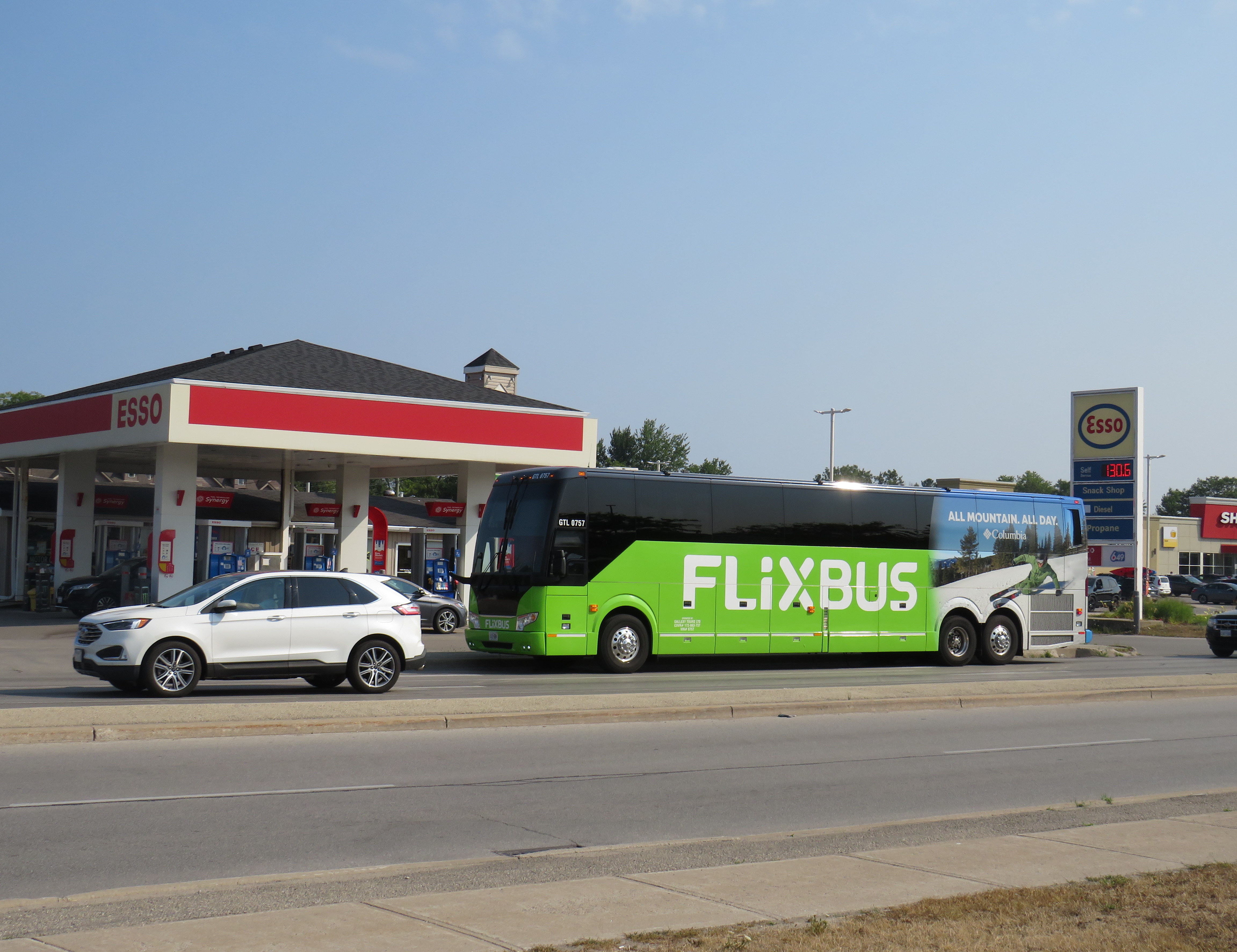
There is one daily Flixbus coach trip from Downtown Toronto and Pearson Airport to Wasaga Beach, continuing onwards to Collingwood, Owen Sound, and Port Elgin. Northbound, the bus leaves Union Station Bus Terminal at 7:30 in the morning and arrives in Wasaga Beach at 10:00. The return bus leaves Wasaga Beach at 4:20 PM and arrives at Union Station at 6:50 PM, though traffic conditions can certainly impact those times. This bus is often nearly or completely sold out.
Flixbus loads in front of an Esso gas station on Mosley Streetat 45th Street
A cheaper and more frequent option is Simcoe County Linx, a regional bus service provided by the County of Simcoe. Linx Route 2, which connects Wasaga Beach to Allandale Waterfront GO Station, connects with GO buses and trains as well as local Barrie Transit buses. Unfortunately, the Simcoe County Linx system has limited service hours, and routes do not necessarily connect with each other. The last buses on Route 2 leave Wasaga Beach and Barrie at 6:30 PM, and there is no weekend or holiday service. (The sole exception is Linx Route 4, which runs between Collingwood and Wasaga Beach seven days a week.)
Both Flixbus and Simcoe County Linx stop on the west side of town, seven kilometres from the main tourist area at Beach Area 1. There are two Wasaga Beach Transit routes connecting these two points, but service is every 60-90 minutes. The limited bus options, combined with a lengthy transfer to get to the main beach areas, makes for an unpleasant trip. The early shutdown of Simcoe County Linx limits the time one can spend in Wasaga Beach, especially if it means a local bus transfer back to the west end of the town.
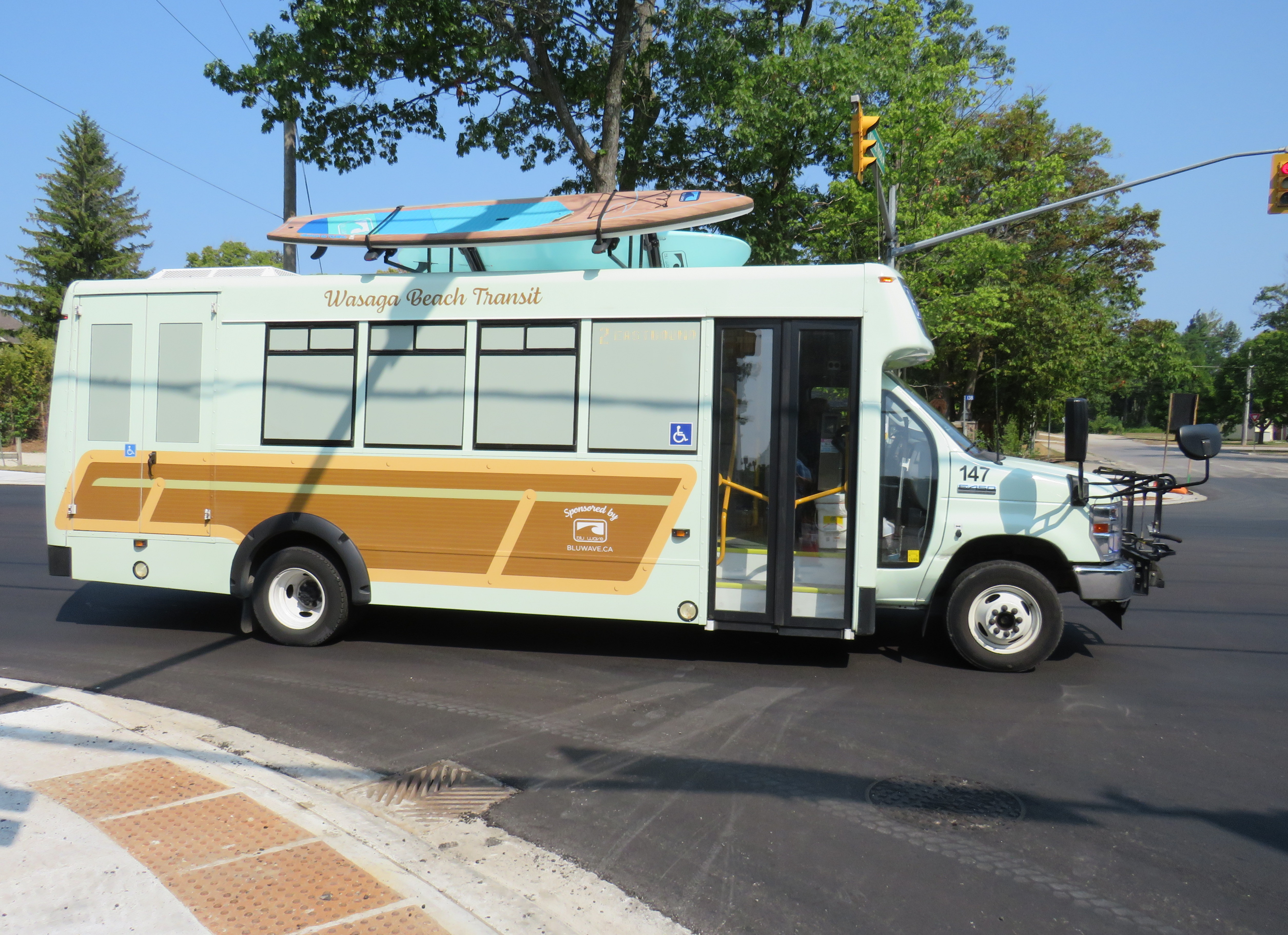
Wasaga Beach Transit minibus, decorated with vinyl wrap and stand-up paddleboards affixed to the roof
From Brampton or Mississauga, travellers must get to either Union Station or Pearson Airport to get the direct Flixbus service or get to the Barrie GO Corridor in order to make the transfer to Simcoe Linx. If there was only a direct bus up Airport Road from Peel Region, Wasaga Beach would be more accessible to another 1.5 million residents.
Furthermore, the only connections to Wasaga Beach are via Airport Road from the south and via Highway 26, a mostly two-lane highway between Barrie and Owen Sound. Wasaga Beach has never had rail access, and the former Barrie-Collingwood Railway through Stayner has been torn up. Both roads are increasingly congested due to both tourist travel and regular commuter traffic; the towns of Collingwood, Wasaga Beach, and Stayner are all growing with new residential subdivisions. Costco is constructing a new retail warehouse at Mosley Street and Highway 26 on the Wasaga Beach’s west side.
This is not just a Wasaga Beach problem. Access to most of Ontario’s other great beaches and resort towns is even more limited. Prince Edward County has a weekday-only bus service between Belleville, Bloomfield, and Picton, but it does not serve Wellington (home of the Drake Devonshire Hotel) or Sandbanks Provincial Park. Port Dover only has a weekday-only on-demand transit service accessible from Simcoe; Sauble Beach is only served by the same Flixbus route that runs through Wasaga Beach. At least Huron Shores Area Transit provides daily service to Grand Bend from both Sarnia and London.
Port Stanley used to have regular electric train service from London — where the municipality owned the railway — until 1956. Even though bus services took over from the L&PS, the only way to get there these days is to drive.
Though several Ontario cities have good urban beaches, accessible by transit — Ottawa’s Britannia Beach and Petrie Island, Hamilton Beach, and Toronto’s many beaches certainly count — there really should be better access for all to the great summer destinations like Wasaga Beach. That not only means protecting the land for public use and environmental preservation, but it also means providing accessible, sustainable, and equitable access by bus and rail. As Wasaga Beach and Collingwood seek to grow their populations and their economy, more transit is needed to connect residents to those additional jobs.
To start, Simcoe County Linx should operate Route 2 evenings and weekends. In the longer term, Simcoe County, its constituent towns, and the cities of Barrie and Orillia should merge their transit systems, focusing on fare integration and facilitating easier transfers between its routes and with GO Transit. There is also room for more intercity bus services between the Greater Toronto Area — particularly Mississauga and Brampton — with Wasaga Beach and Collingwood, offering more capacity and faster, more direct options. On my way home on Thursday, August 14, it took me over four hours to get back to Toronto Union Station via Simcoe County Linx and GO Transit buses; driving takes less than half that time, even with traffic.
Wasaga Beach is a treasure of provincial significance. It deserves to remain owned by the public and fully open to all, with better access to those who can’t or don’t want to drive.
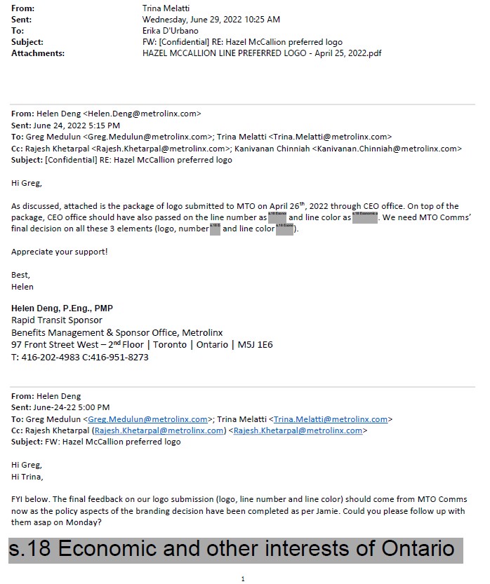
Though much of the information I received was redacted, I was able to learn that the Cities of Brampton and Mississauga had already come up with a brand for the new transit line. Metrolinx and the provincial government had to reimburse them for the costs once the Minister of Transportation intervened to force a new name upon the project, which cumulated with a love-in photo op on February 14, 2022.
Among the information redacted in the information package sent to me, six months after my initial Freedom of Information request, was the LRT line’s colour and number. They were redacted under Section 18(1) of the provincial Freedom of Information and Privacy Protection Act, citing economic and other interests of Ontario.
Redacted line colour, number, and logo
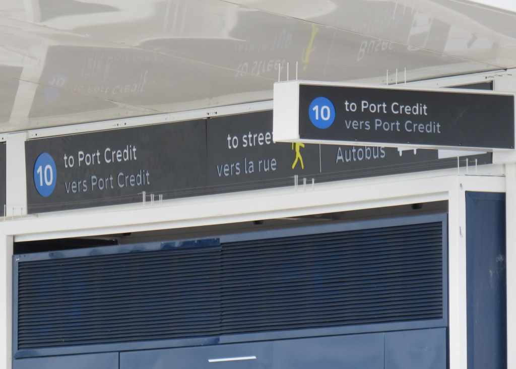
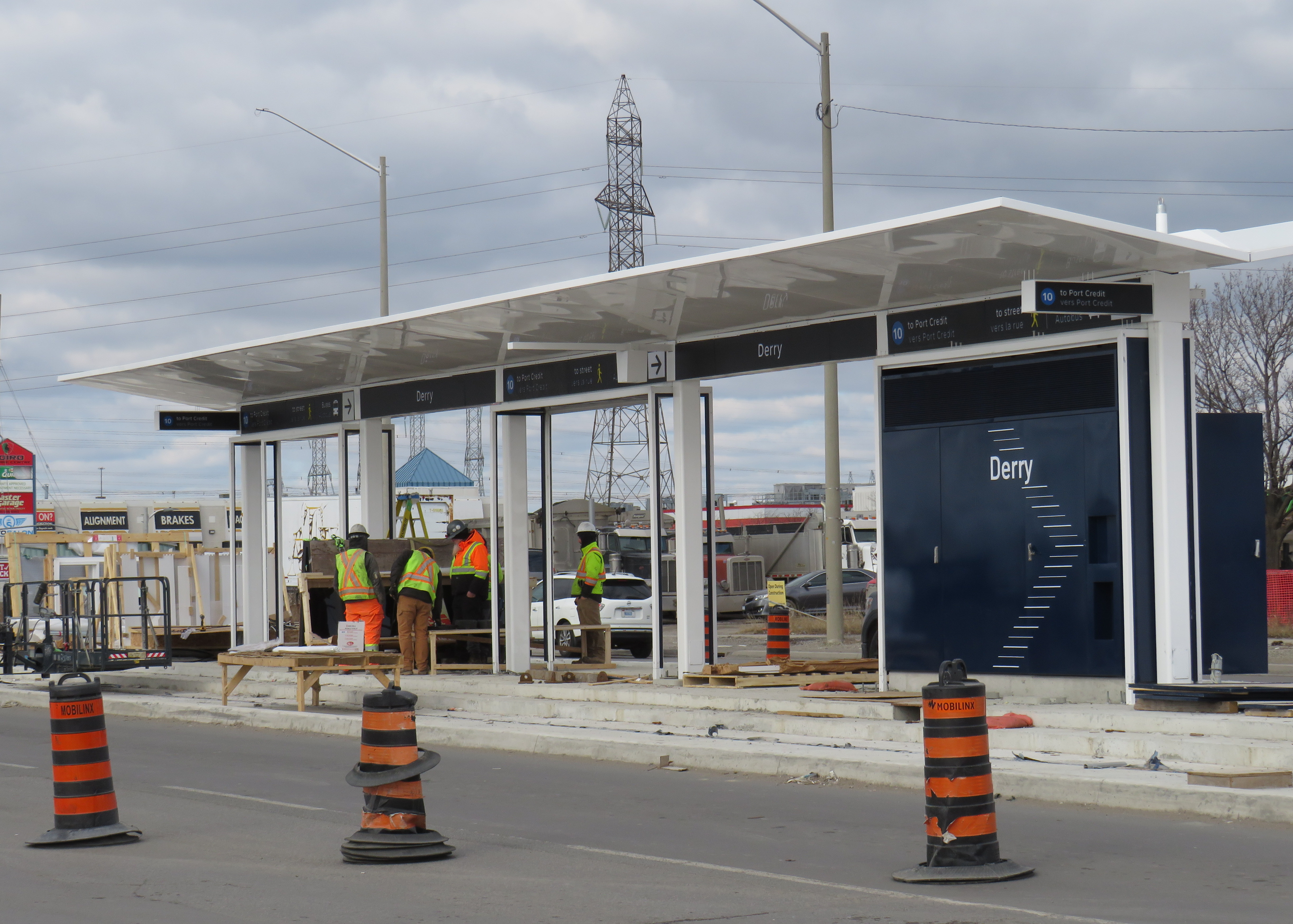
At Derry Road, though, the secret is out. The Hurontario Line will be Line 10, represented by a bright blue colour similar to the former Line 3 Scarborough RT.
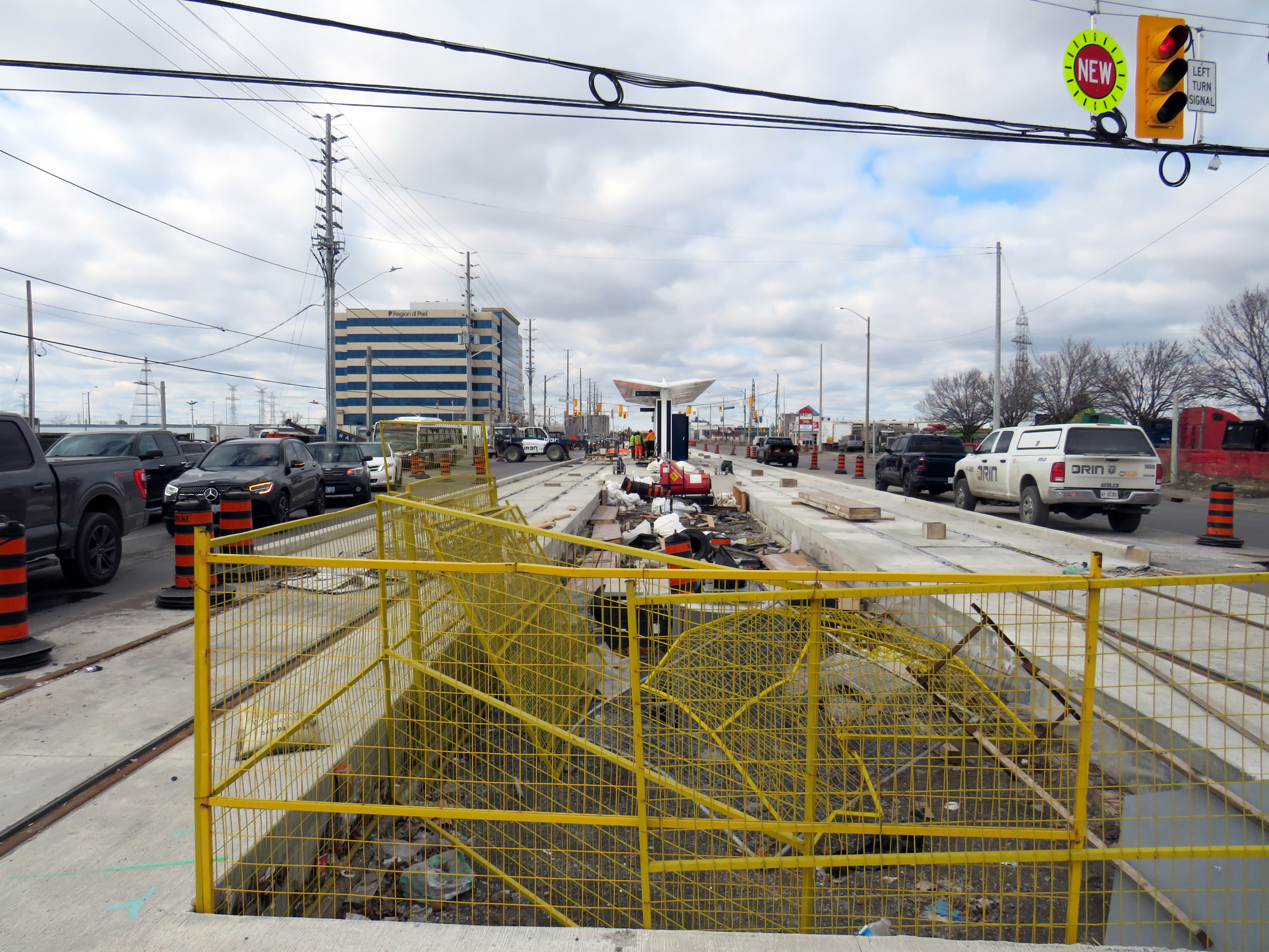
Derry LRT station under construction
Line 10 is a good choice for this corridor. Hurontario Street and Main Street through Mississauga and Brampton used to be part of provincial Highway 10, which was later bypassed by Highway 410 and downloaded to the two cities between the 1980s and the 2000s. It will also be the first Metrolinx-managed rapid transit project completely outside the City of Toronto, where Lines 1 through 6 are already assigned to the existing subway and the Eglinton-Crosstown and Finch West LRTs (with Line 3 reused for the Ontario Line when it opens).
Brampton Transit and Miway currently operate bus services with that route number (10 South Industrial and 10 Bristol-Britannia), but those should be easy to change in advance of the LRT’s opening, which will take place in late 2025 or early 2026, given the construction progress so far.
I remain puzzled and somewhat annoyed that this information was kept secret, and for what reasons. Revealing a line number and colour in a freedom of information request should not have been important. If it was to protect for another government photo opportunity, then that is now moot. Who is the Hurontario LRT for? The Doug Ford-led provincial government, or the people who will ride it?
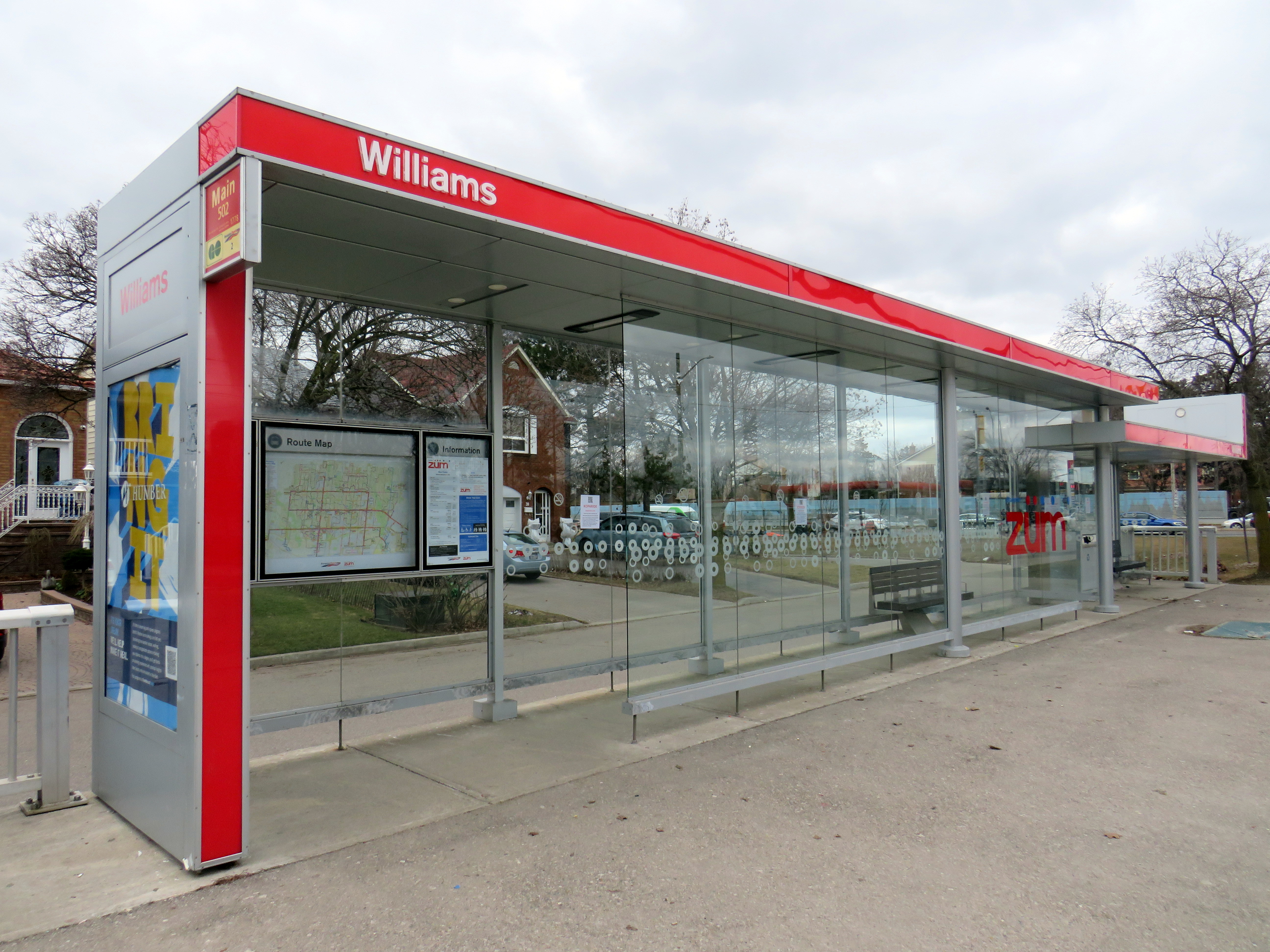
Finally, I note that like the shelters going up for the Finch West LRT and the surface stops of the Eglinton LRT, there is very little protection from the elements at the Hurontario LRT stops, with only a canopy and a single wall supplying shade and cover from the rain or snow. Compare the Derry Road LRT stop with older Brampton Züm shelters, which include enclosed waiting areas, benches, and even winter heating.
Brampton Züm stop with full glass enclosure, benches, and a button to activate a heater in the winter
One more thing…
To my longtime followers as well as my occasional readers, thank you for your interest and support. Last year’s FOI request cost me $525.00. Sadly, freedom of information isn’t free. If you like my work and want to contribute to my online mapping and webhosting costs, please consider buying me a coffee.
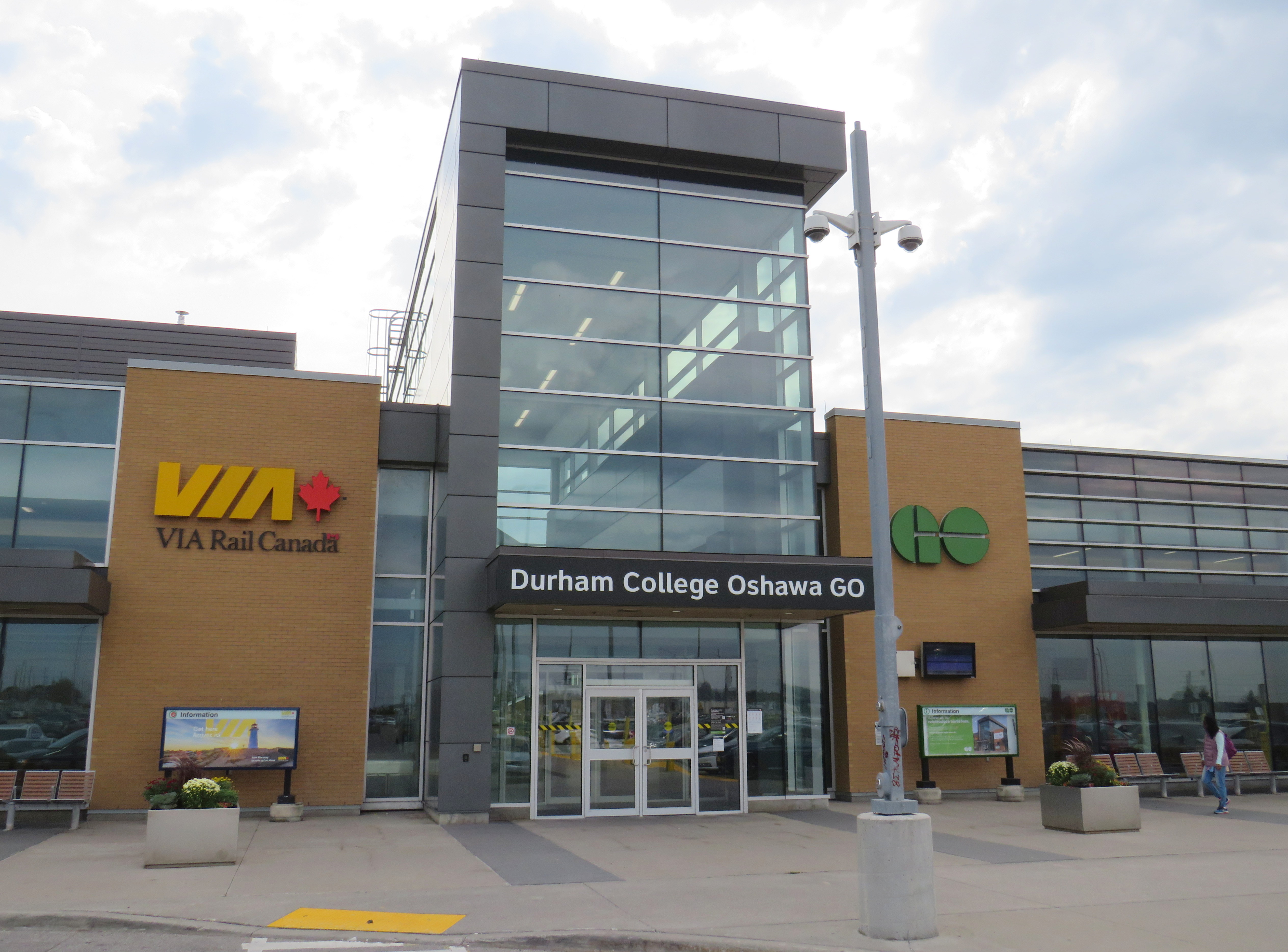
On Tuesday, October 4, Metrolinx announced a new name for Oshawa GO Station, the eastern terminus of its busy Lakeshore Corridor. In a ten-year agreement with Durham College, a publicly funded post-secondary institution, the station will now be known as “Durham College Oshawa GO.” This was announced on Metrolinx’s Twitter account, Durham College’s social media, and on the GO Transit Lakeshore East Twitter account, which usually advises passengers of train delays and cancellations.
📢 Oshawa GO is now Durham College Oshawa GO!
Customers will start see the new name on the station building itself and on assets throughout our system. pic.twitter.com/dAAvCjOz2e
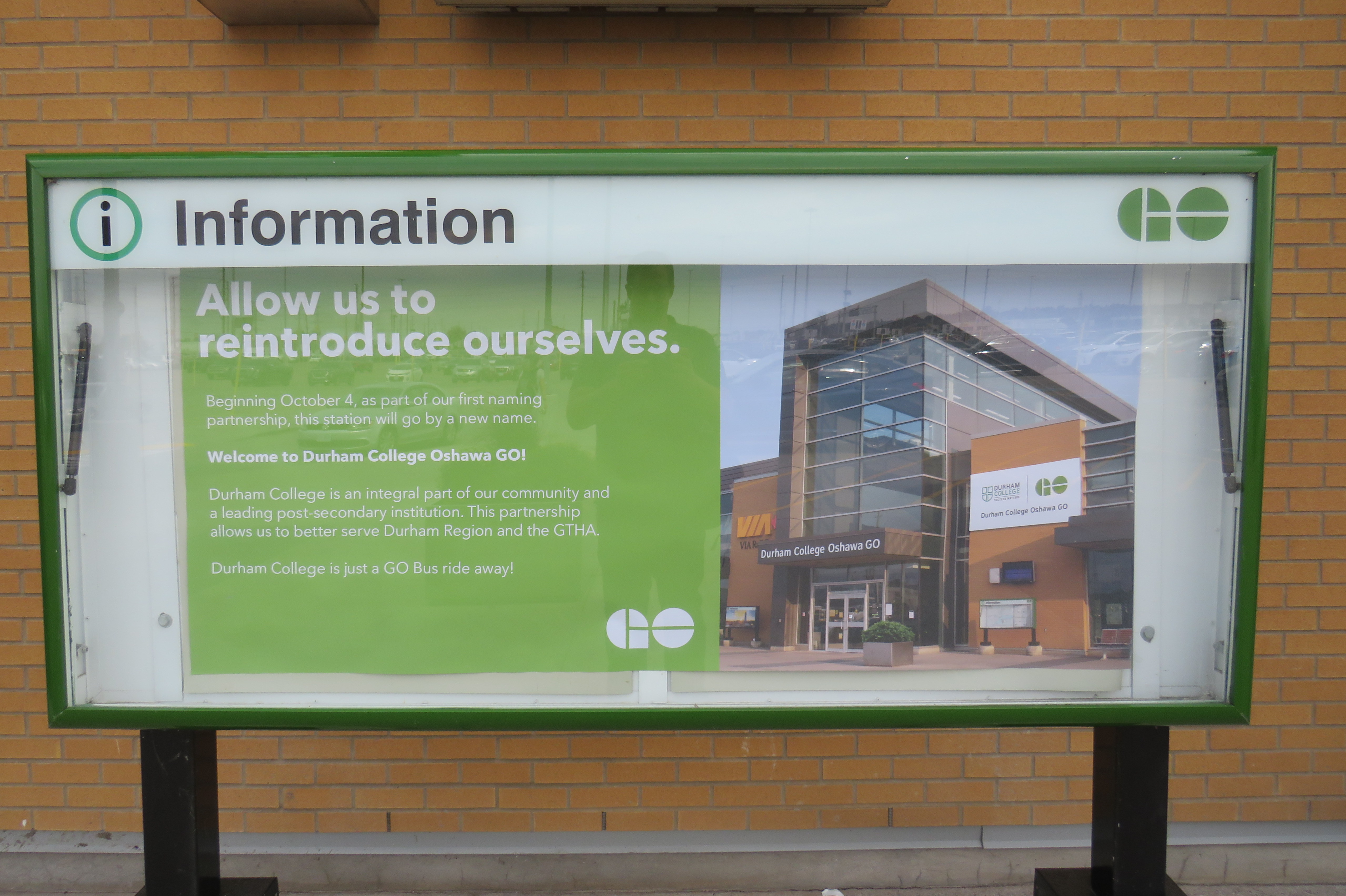
GO Transit Lakeshore East Train tweet on October 4“Allow us to reintroduce ourselves” – promotional poster at Oshawa Station proclaiming the new “Durham College Oshawa GO” name
Metrolinx, the regional transit agency that operates GO Transit, claims that “the partnership allows us to better serve Durham Region and the GTHA” in its communications, including an informational poster in front of the station building.
The news did not go over well with GO Transit customers and transit users across the Greater Toronto Area; Metrolinx later deleted its tweet after it was “ratioed” — meaning that negative comments and quote-tweets outnumbered the number of positive responses by a large margin. It is easy to understand why the station renaming was not popular.
Firstly, though “Oshawa” remains in the station name, Durham College comes first with the new moniker. Schedules, signs, and maps will be updated to reflect the new name, while announcements by on-board staff and digital schedule information already reflect the new name. VIA Rail, which shares the station with GO Transit, is not a party to the agreement, and will likely continue referring to the station as “Oshawa.”
Specific details of the agreement, such as how much Durham College is paying for the branding agreement, remain confidential.
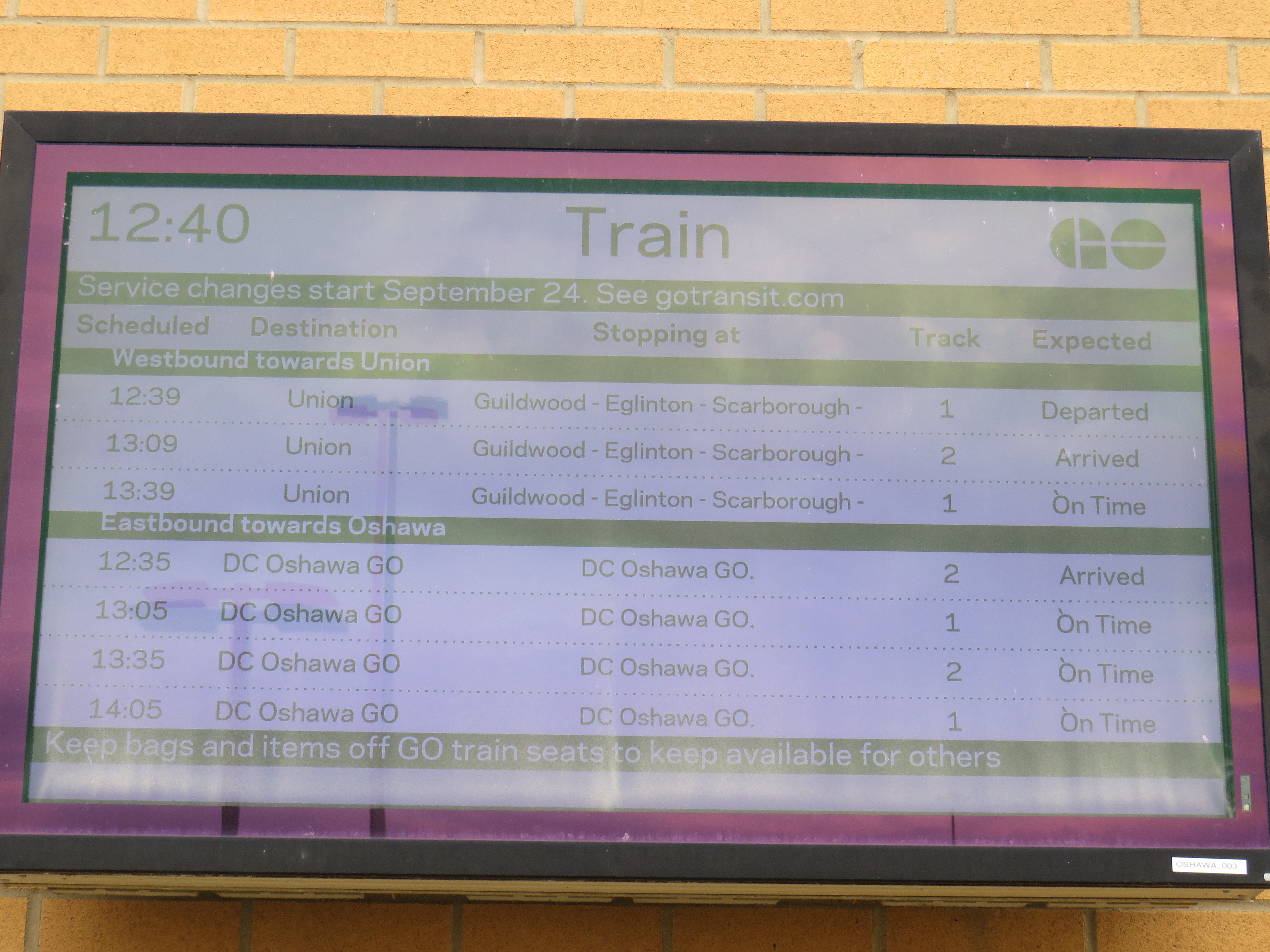
On GO Transit schedule boards, Oshawa Station now appears as “DC Oshawa GO”
The new policy of naming rights agreements goes against years of Metrolinx policy for naming stations. When planning the Eglinton-Crosstown LRT, it developed five standards for naming stations and stops:
1. Simple. Simple names are easier to remember
2. Logical. Logical names provide a mental link when trip planning: they should be relevant to the area they reside
3. Durable. Names should be relevant as long as the station exists
4. Self-Locating. Names should allow users to mentally locate themselves within the region
5. Unique. A unique name is one that cannot be confused with any other.
“Durham College Oshawa GO” violates most of the above principles. The name is now a mouthful, much like “Vaughan Metropolitan Centre” (another controversial station name that the TTC objected to, but was overruled due to political considerations), and is no longer simple. The agreement only lasts ten years, so it is not durable. As I will explain further, the name is also neither logical, self-locating, nor unique.
Durham College has three campuses. Its main campus is located in the north end of Oshawa, on a site shared with Ontario Tech University. GO Transit has a bus stop there called “Ontario Tech/Durham College” that is served by GO Transit Route 56 on weekdays, and Route 52 on weekends and holidays. The main Oshawa campus is a two hour walk from the GO station, a 25-35 minute GO bus ride, or a 20 minute drive from the station. This was the main reason why transit users were ridiculing the new station name on Twitter.
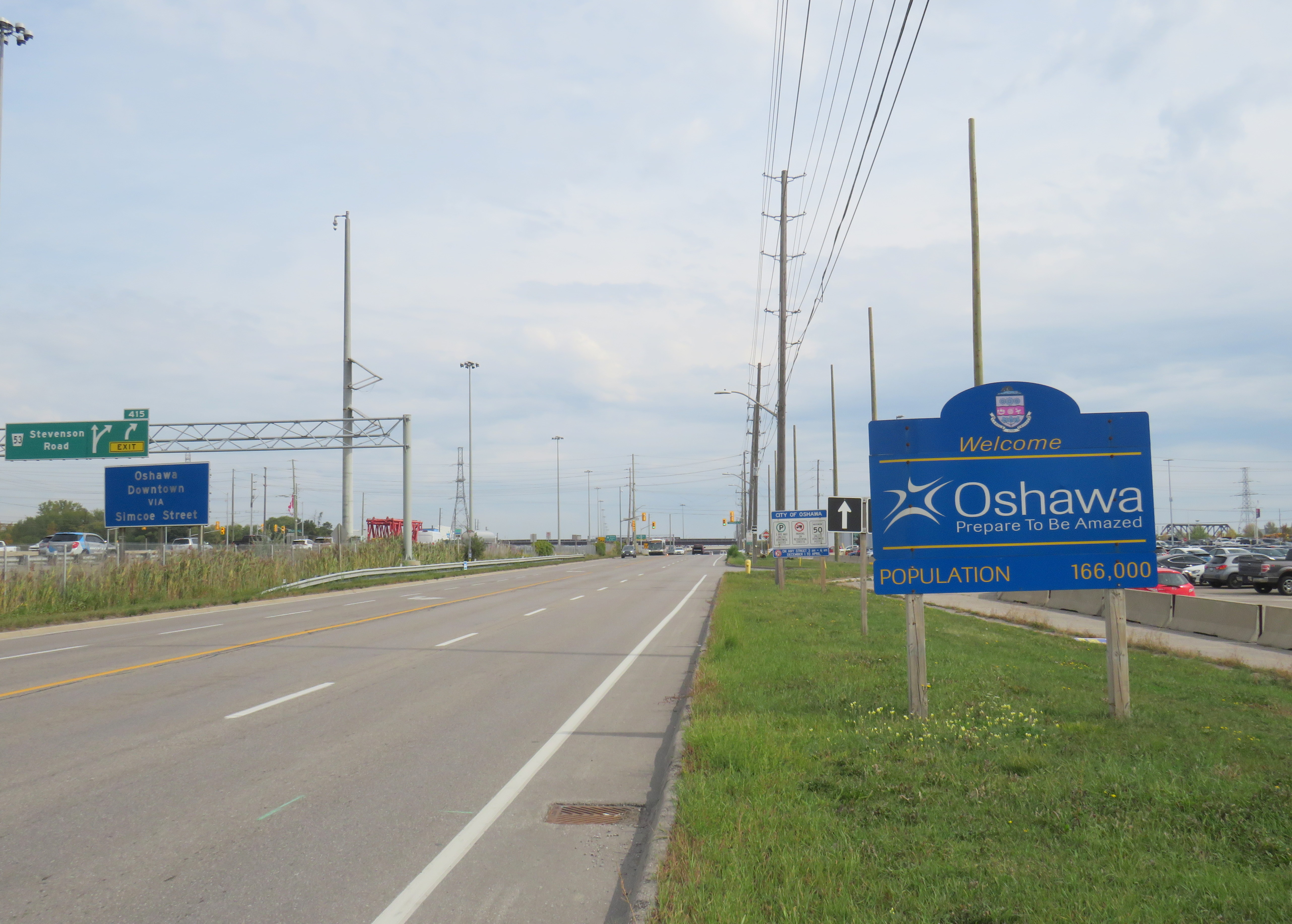
Durham College’s Whitby Campus is much closer to Oshawa GO Station, in fact, it is less than 500 metres from the Oshawa GO Station parking lot as the crow flies. Oshawa Station is actually right on the border of Oshawa and Whitby, with the “Welcome to Oshawa” signs next to the main GO Transit parking lot. The overflow lot for Oshawa GO is actually in the Town of Whitby.
The “Oshawa: Prepare To Be Amazed” sign marking the city limit sits next to the GO Station parking lot.
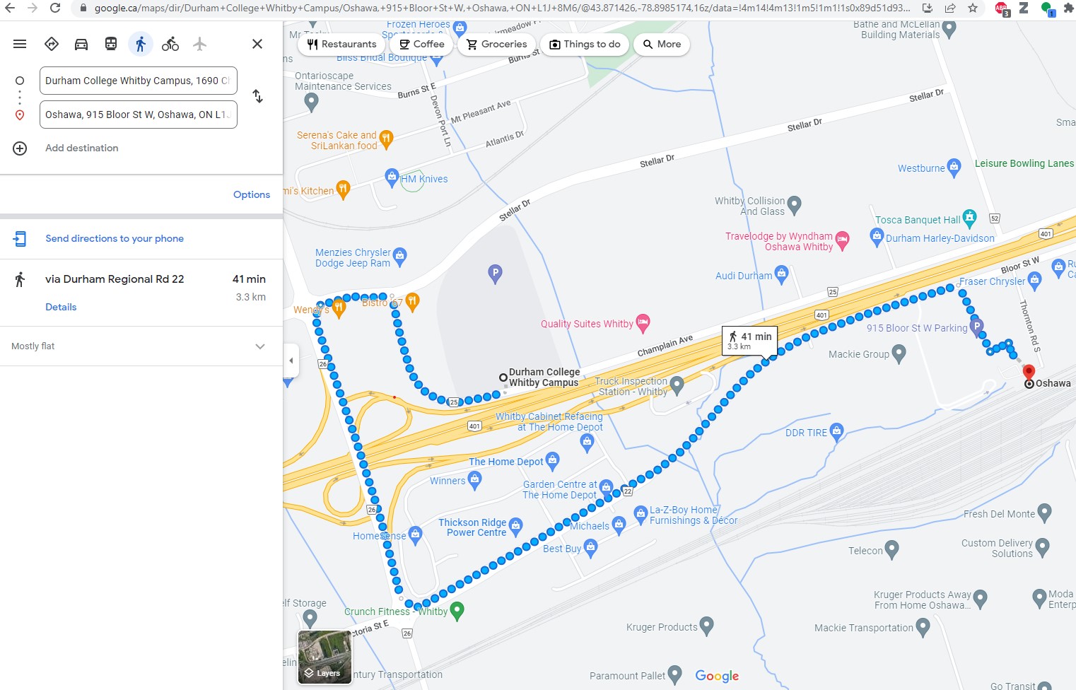
However, the Whitby campus is even harder to get to from Oshawa GO than the main Oshawa campus because it is separated by Highway 401. It is a 41 minute walk between the station and the Whitby college campus along Victoria Street (which has no sidewalks along most of its length), Thickson Road, Stellar Drive, and Champlain Avenue, though a footbridge over the highway would reduce the walking time to a more comfortable 15 minutes.
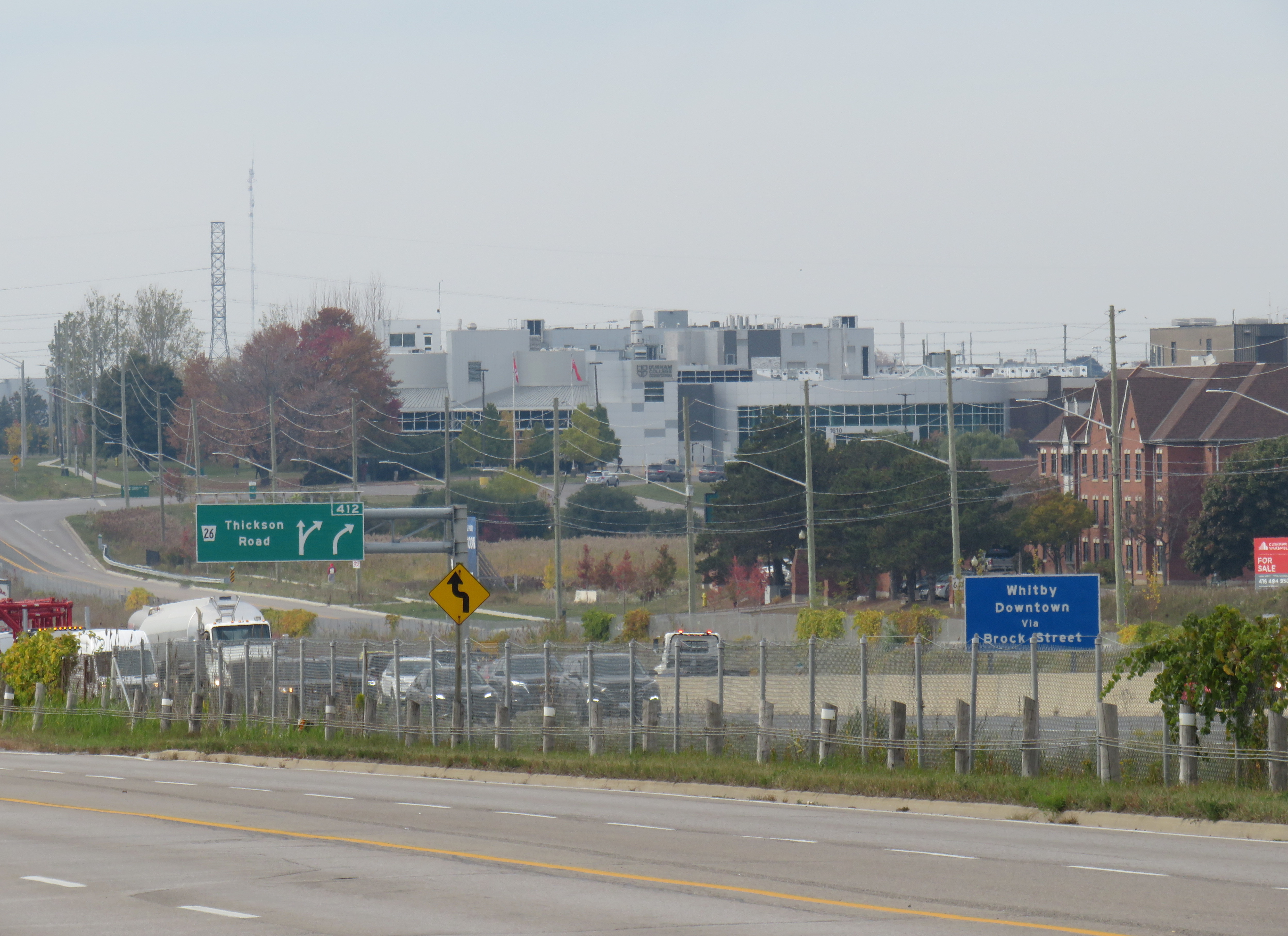
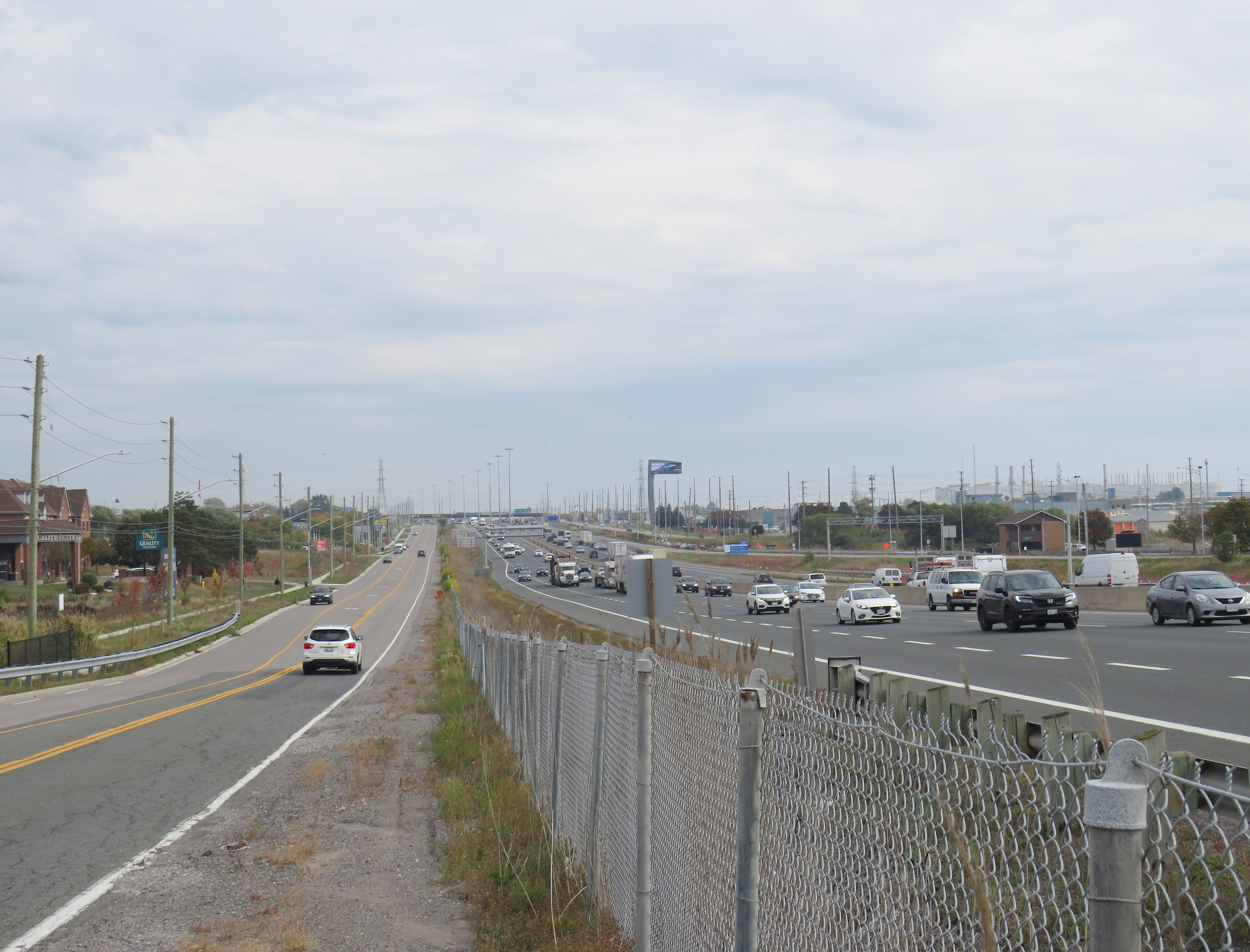
Google Maps directions from Oshawa Station to Durham College Whitby CampusLooking northwest from the Oshawa GO parking lot towards Durham College Whitby Campus, the large grey building above and to the right of the green Thickson Road exit signLooking east on Champlain Boulevard in front of the Whitby campus across Highway 401 towards Oshawa GO Station, which is marked by the tall digital billboard towering over the roadway
The irony is that both major Durham College campuses are better reached from Whitby Station than the newly named “Durham College Oshawa GO.” There are no direct buses to the Whitby Campus from Oshawa Station, but Durham Region Transit (DRT) Route 917 provides regular service from Whitby Station. Furthermore, DRT operates more frequent service on Route 905 between Whitby Station and the Oshawa Campus than GO Transit does from Oshawa Station. Google Transit itself recommends transferring at Whitby to DRT, rather than at Oshawa, because the connections are more convenient. GO Route 56 operates only every hour on weekdays, and Route 52 runs every two hours on weekends and holidays. Meanwhile Route 905 stops in front of the Oshawa campus every 15-30 minutes, 7 days a week.
The connection at Oshawa Station to Durham College’s main Oshawa Campus makes sense only when transferring from a VIA Train, or from GO Transit Route 88 from Peterborough and Clarington.
Excerpt from Durham Region Transit system map, with Oshawa and Whitby stations and both Durham College campus locations highlighted
Therefore, at this point, renaming Oshawa Station to “Durham College Oshawa GO” makes no sense. The new name violates basic wayfinding standards, while Durham College itself is better accessed from a different GO Station. Perhaps Durham College could operate a shuttle service to its campuses from the station, making the co-branding a more plausible.
Though I am critical of the process, I am sympathetic to Metrolinx’s position. I do not believe they were supportive of the province’s decision to rename a major LRT project for a political ally and paid advisor to Doug Ford’s Progressive Conservatives. I strongly believe there are many within the organization who are not happy about the station renaming agreements either. They must work with a very “hands on” government that is eager to promote new transit projects and benefit their supporters.
Map of Doug Ford’s proposed 25 wards and the City Council-approved 47 ward boundaries
Late last week, the newly elected Ontario Progressive Conservative government announced that they would be imposing a new electoral map on the City of Toronto, a decision that would eliminate the new 47 wards approved by Toronto City Council, replacing them with the same 25 boundaries used by the federal and provincial governments.
It’s very clear that Premier Doug Ford’s plan, which requires a new piece of legislation, ironically titled the “Better Local Government Act,” is vindictive and mean-spirited because it only affects the City of Toronto, which rejected Doug Ford’s 2014 mayoral bid. It quashes the hopes of many young, racialized, and progressive candidates looking to change the make up of a council that has generally supported Mayor John Tory’s agenda. It is unfair to candidates that ran in good faith, started campaigns, raised funds, and spent money hiring staff, purchasing materials, and renting campaign offices.
But most of all, Ford’s actions are an attack on local democracy because of the haste with which they are being made, at the end of the nomination period for those approved 47 wards. They ignore the years of study by independent experts and several rounds of public consultations. They also benefit Toronto’s suburban areas, which are growing at a far slower rate than downtown Toronto, North York Centre and Etobicoke’s waterfront area, which will be disproportionately affected by this arbitrary decision.
Each new ward was designed to have an average population of 61,000, with a population range of between 51,800 and 72,000 (+/- 15%). They were designed to last for four election cycles, to be re-drawn before the 2034 election.
It is worth noting that the independent experts looked at using the 25 federal/provincial boundaries twice. In the first study, they were rejected early on because they would not “meet the tests of effective representation.” The federal boundaries, which are also adopted by the province of Ontario, are based on population counts from the 2011 Census, and are already seven years out-of-date, while the consultants were tasked with developing new ward boundaries to last 16 years. Even a 50-ward solution (which mimics the old 44 wards based on the 22 federal ridings that were established in 1996 and came into effect with the 1997 federal election) would result in severe variations in population.
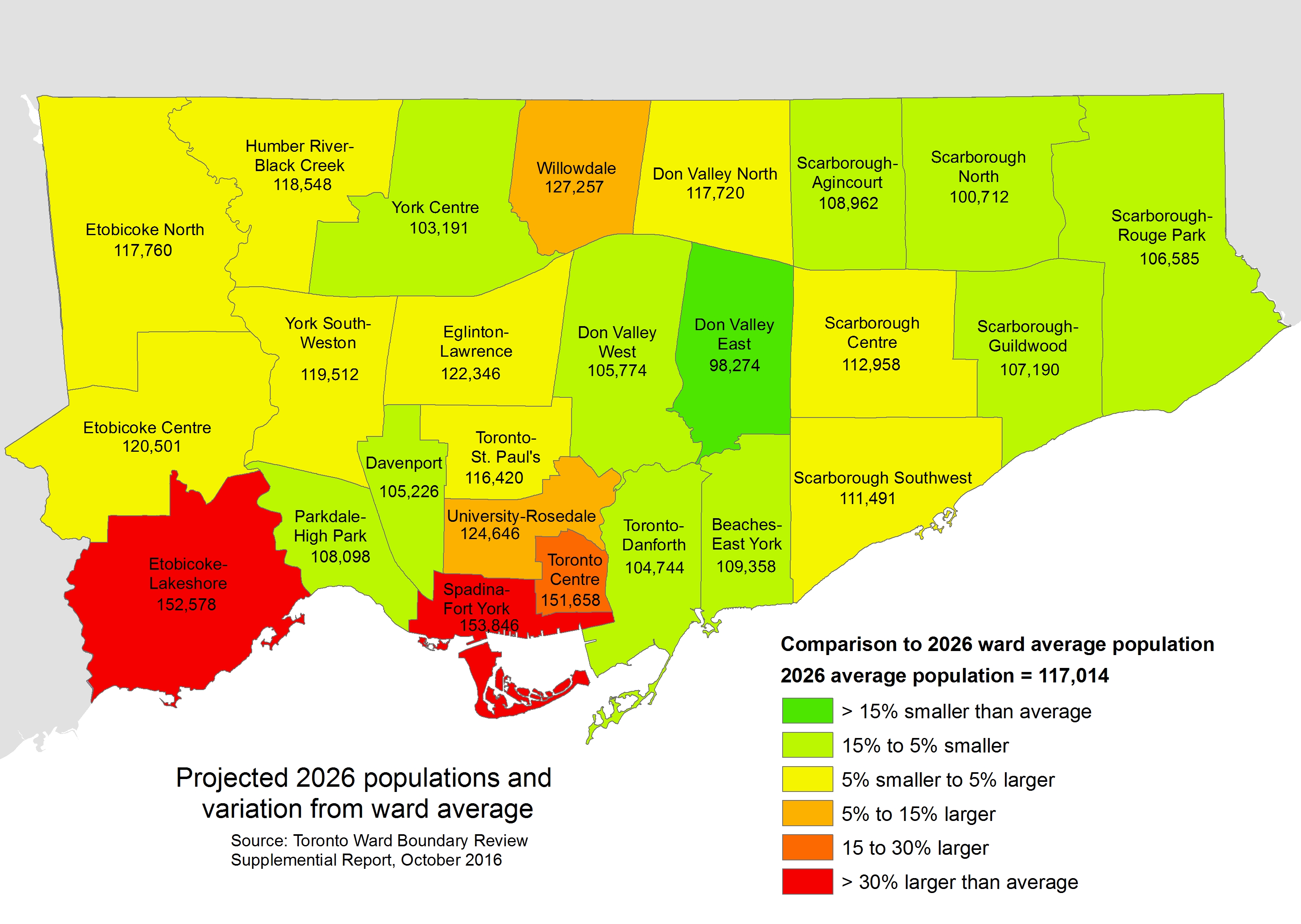
How the 25 ridings, if used for Toronto’s ward boundaries, will vary in population by 2026
After Tory’s Executive Committee tasked the Toronto Ward Boundary Review team to re-examine options that would see fewer than 47 councillors elected in 2018, they re-examined using the 25 ward boundaries. They found that in 2026, three of those wards — Toronto Centre, Etobicoke-Lakeshore, and Spadina-Fort York — would have populations over 30% higher than the ward average in 2026. Willowdale and University-Rosedale would also have had much larger populations than the city average.
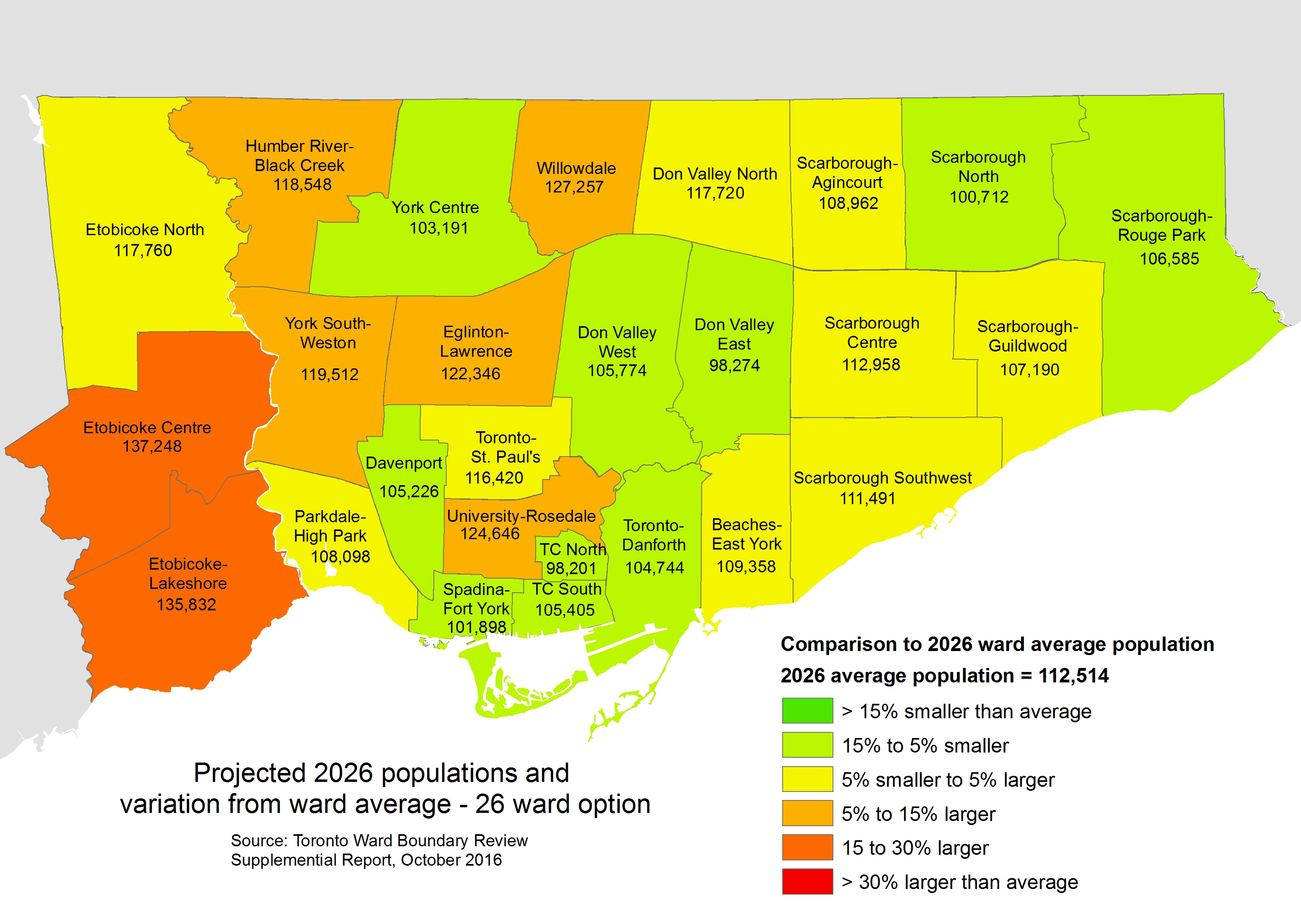
The review team also looked at a 26-ward option that mostly maintained the riding boundaries but added a new ward downtown out of the Toronto Centre and Spadina-Fort York constituencies and adjusted boundaries in southern Etobicoke. Even then, Etobicoke Centre and Etobicoke-Lakeshore would still have populations over 20% higher than the city-wide average. Despite making some adjustments for population growth, this option would have not have corresponded with some ridings, and was also not recommended.
How the modified 26 ridings, if used for Toronto’s ward boundaries, would have varied in population in 2026
For those reasons, and to support local representation, the 47-ward solution was once again recommended, and was approved by City Council in November 2016. Councillors Justin Di Ciano (Ward 5) and Giorgio Mammoliti (Ward 7) then appealed the new boundaries to the Ontario Municipal Board, but they were dismissed. The 47-ward solution has survived despite it all.
Mayor Tory may have brought back decorum to the mayor’s office after an embarrassing period under Doug Ford’s brother Rob, but he has pushed an austerity agenda, and has failed to show leadership on police reform, wasteful infrastructure spending, and safe streets for pedestrians and cyclists. His initial reaction, to call for a referendum on Ford’s plan to cut Toronto’s council, was a characteristically weak response; he was later pushed into supporting a legal challenge by an angry public. Meanwhile, some of Tory’s allies, like Di Ciano, David Shiner, and Glenn De Baeremaeker, support Ford’s actions.
Ford’s attack on local democracy is an insult to candidates who have already put their names forward for election and launched their campaigns. It undermines the City of Toronto’s legislated responsibility to decide its own ward boundaries. And it will only exasperate existing disparities in council representation.