In this short post, I look at the election results in Ward 37 and Ward 38, Scarborough Centre. Ward 37, west of Brimley Avenue, is represented by Councillor Michael Thompson, while Ward 38, to the east, is represented by Councillor Glenn De Baeremaeker. The results of the mayoral race were nearly the same in Ward 37 and Ward 38. Doug Ford came in first place in both wards with about 51% of the vote, and won all but three polls in Scarborough Centre. John Tory came in a distant second place with less than 30% of the vote (and came in first place in the remaining polls), while Olivia Chow took just over 15% of the vote. Both incumbent councillors were easily re-elected.
Author: Sean Marshall
-
Mapping the 2014 Toronto Election: Wards 35 and 36
After many weeks of presenting poll-by-poll maps of the council and mayoral races in the 2014 municipal election, I finally reach the home stretch: the final ten wards located in the former municipality of Scarborough. Of all the six municipalities that were amalgamated into the City of Toronto, Doug Ford did the best here. (Even in the Fords’ home turf of Etobicoke, John Tory came in first place in three of that suburban area’s six wards.)
In this post, I look at the two wards that make up Scarborough Southwest, Ward 35 and Ward 36.
Ward 35, the north half of Scarborough Southwest, is a triangular ward bordered by Victoria Park and Eglinton Avenues and Metrolinx’s Lakeshore railway line. Ward 35 is represented by Michelle Berardinetti, who was first elected to city council in 2010, the spouse of Liberal MPP Lorenzo Berardinetti (who represents Scarborough Southwest at the provincial level). Ward 36, south of the railway corridor, straddling Lake Ontario, is represented by Gary Crawford. Unlike Ward 35, ward 36 includes relatively affluent neighbourhoods such as Fallingbrook (which neighbours the prestigious Beaches neighbourhood) and those abutting the Scarborough Bluffs.
Ward 36 was the only ward in Scarborough where John Tory came in first place; Doug Ford was the first choice in all nine other wards east of Victoria Park Avenue.
Interestingly, even though the dubious extension of the Bloor-Danforth Subway wouldn’t serve Wards 35 or 36 by any means, both incumbent councillors were strong supporters of the expensive project that replaced plans for the replacement of the existing SRT with an extended light rail corridor.
-
Mapping the 2014 Toronto election: Wards 33 and 34, Don Valley East
With my vacation over, and back in Toronto, it’s about time to finish posting maps of the poll-by-poll results of the 2014 Toronto municipal election. In this post, I take a quick look at Wards 33 and 34, Don Valley East.
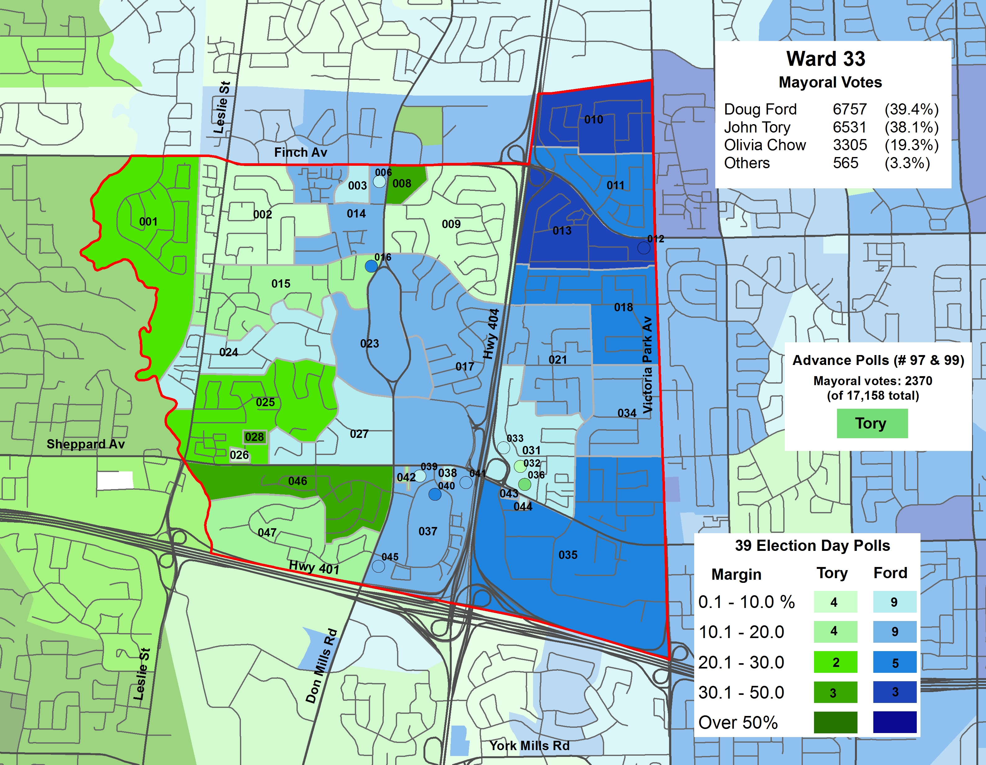
Ward 33, in North York’s northeastern corner, is represented by centre-left veteran councillor Shelley Carroll. Ward 33 lies between Finch Avenue and Highway 401; Fairview Mall and Don Mills Station on the Sheppard subway line are close to its geographic centre. Ward 34 is represented by conservative Councillor Denzil Minnan-Wong, a municipal politician first elected in 1994 to North York City Council. Doug Ford came in first place in Ward 33, while John Tory came first in Ward 34. In both wards, Olivia Chow came in a distant third.
Ward 33
In Ward 33, Doug Ford won a plurality of the votes (39.4%), but by a very small margin; only 226 votes separated Ford and John Tory (who took 38.1% of the vote) in that ward. As in nearly all suburban wards, Olivia Chow came in a distant third race, netting only 19.3% of the vote there. Tory came first in most polls on the west side of the ward, closer to Yonge Street (Tory came in a comfortable first place in neighbouring Ward 24), while Ford did better in polls to the east, closer to Victoria Park Avenue and Scarborough. Condos, such as polls 008, 036, 038, and 042, picked Tory, while rental highrises went for Ford, as did single-family housing tracts east of Highway 404. Ford’s support for extending the Sheppard Subway (a money pit in this author’s opinion) was likely one factor that explains the geographic split.
Shelley Carroll, a talented centre-left councillor and Mayor David Miller’s budget chief, was easily re-elected with 60.5% of the vote, winning all but one poll. Her nearest competitor, Divya Nayak, took 21.9% of the vote, and won only one poll, 036, a high-rise rental tower on the Don Mills “Peanut.”

Poll results of the mayoral race in Ward 33

Poll results of the council race in Ward 33 -
The new American streetcar: A visit to Detroit, Cincinnati, Atlanta, and Tampa
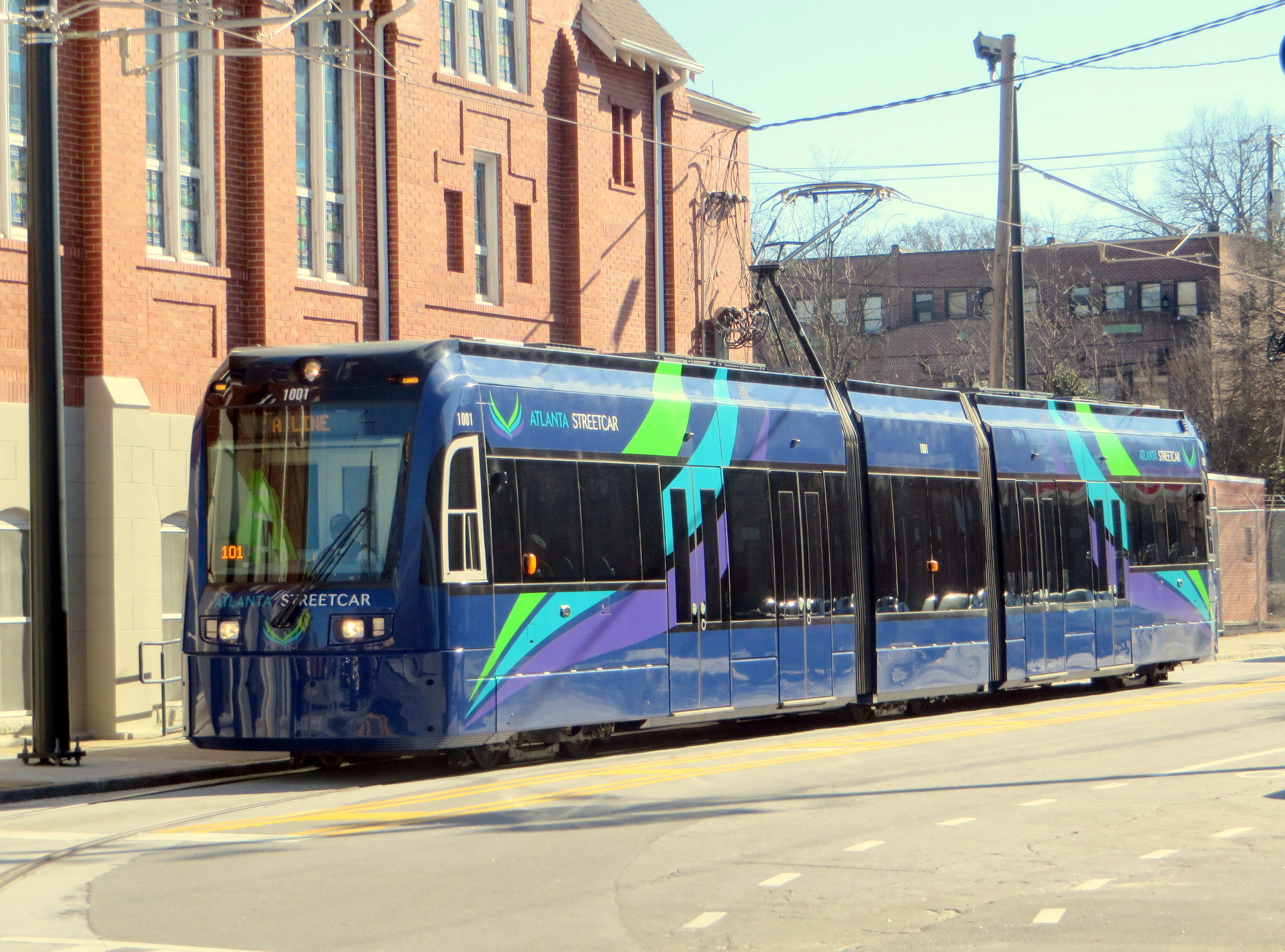
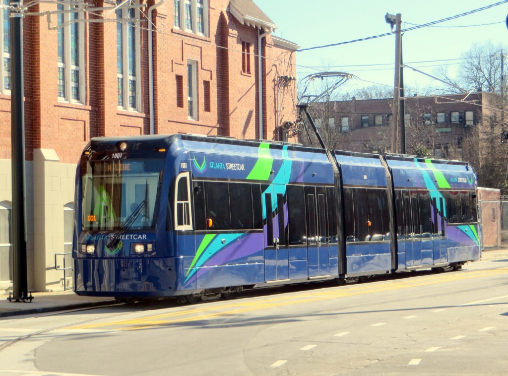 The brand new Atlanta Streetcar
I went on a short vacation, driving down Highway 401 and Interstate 75 from Toronto to Florida’s Gulf Coast. From there, I went on to Miami and Miami Beach, before flying back north; first to New York, then back home to Toronto.
On the drive down, I took the opportunity to visit some of the cities along the way. Once I crossed the border and entered Detroit, my route followed Interstate 75 all the way. The great highway, 2,875 kilometres (1,786 miles) long, goes from the Canadian Border at Sault Ste. Marie to Naples, Florida, and via Alligator Alley to just north of Florida on the Atlantic Coast.
Interstate 75 passes through Detroit, Cincinnati, Knoxville, Chattanooga, Atlanta, and Tampa; all were stops along the way. Four of those cities — Detroit, Cincinnati, Atlanta, and Tampa, all are either building, or have completed, new streetcar lines. Tampa’s TECO Line is a vintage heritage streetcar (like those in New Orleans and Memphis), the other three are modern streetcar lines that are or will be similar to those in Portland and Seattle — short urban circulator routes. Nearly all streetcar routes build in the last decade have followed Portland’s model of a modern circulatory streetcar; older systems, such as Tampa’s (or those in Memphis and newer lines in New Orleans) are heritage-type streetcars, using vintage or replica equipment on lines that are part of the regular transit system, but geared more to tourists and occasional riders.
Unlike light rail, (think Calgary’s C-Train, or Los Angeles’ Gold, Blue, Green, or Expo Lines), the new streetcar systems being built in the United States have short stop spacing, usually run in mixed traffic (or in separate lanes on city streets), and are often built to promote urban development, tourism and/or local transit ridership. The systems planned or being built here in Ontario, such as Ottawa’s Confederation Line, or Kitchener-Waterloo’s ION line, should be considered to be light rail (though ION will be partially running in city streets in Uptown Waterloo and Downtown Kitchener).
Detroit
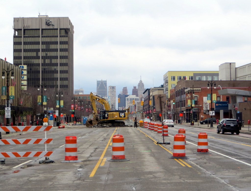
Looking down Woodward Avenue towards Downtown Detroit, January 2015After crossing the border, I made a quick stop in Detroit to see the progress on the M-1 Rail streetcar.
The 12 stop, 5.3-kilometre (3.3 mile) streetcar route, now under construction, will run on Woodward Avenue, Detroit’s main street, from Congress Street, downtown near the river, up to Grand Boulevard, in the New Center district. The streetcar line will link the reviving downtown core, three major sports venues and live theatres, Wayne State University and the fabulous Detroit Institute of Arts, and Detroit’s Amtrak Station. (Map)
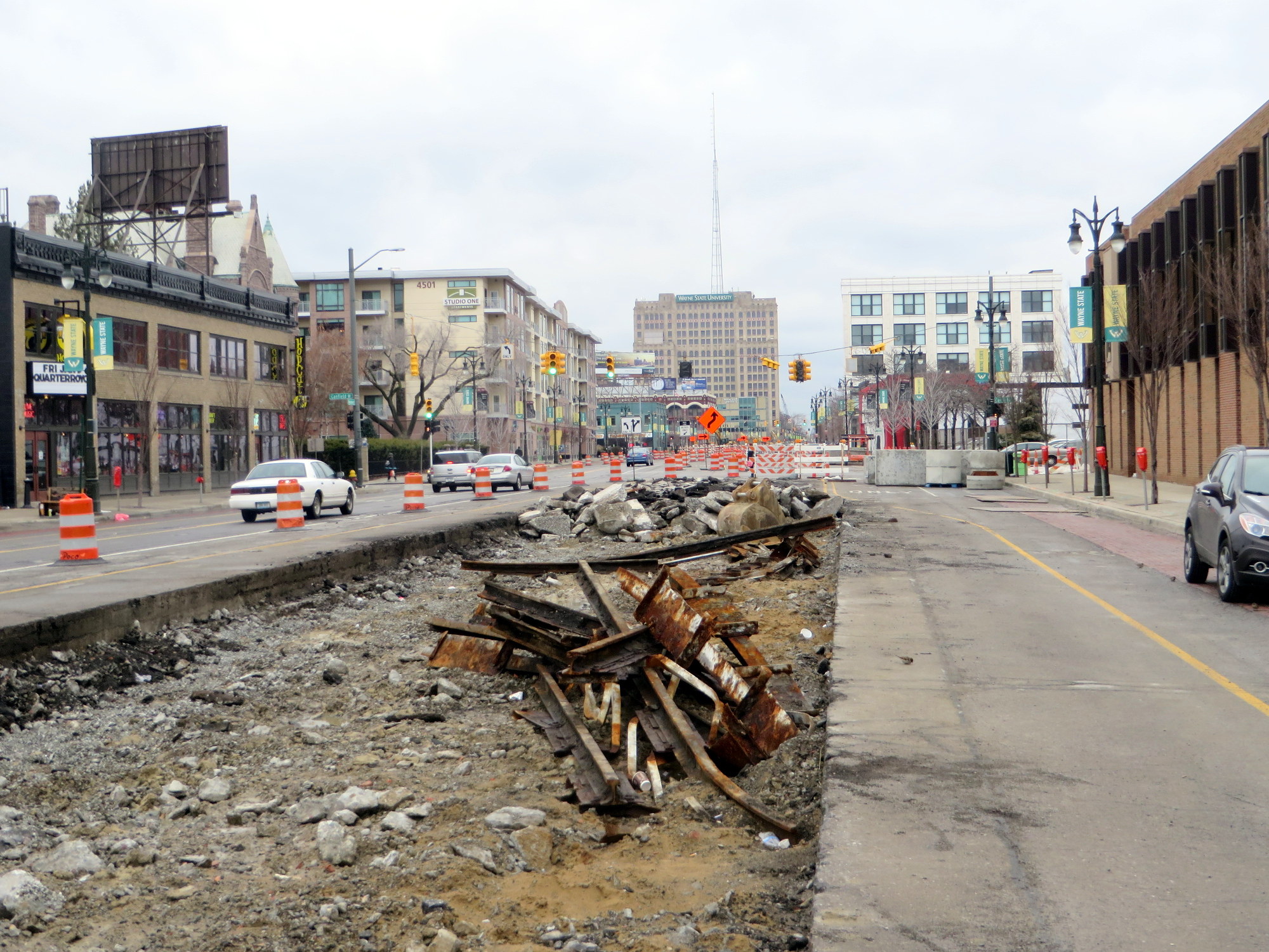
Near Wayne State University, the roadway was being rebuilt to accommodate the new tracks; crews had dug-up the old streetcar tracks last used in 1956. Detroit once had a very extensive streetcar system that was one of the first to be publicly owned (Detroit and Toronto were pioneers in this respect); Detroit’s Department of Street Railways (DSR) even had a fleet of modern PCC streetcars in the post-war era. But the Motor City opted for buses, and it, with state and federal financing, was busy building a network of freeways to serve that rapidly decentralizing urban area. The M-1 streetcar is scheduled to open in 2016; 60 years after the last Woodward streetcar pulled into the carhouse in Highland Park for the last time.
The route will mostly operate in curb lanes, much like other modern streetcar routes in Portland, Seattle, and the new Atlanta Streetcar discussed below. Interestingly, only the central section will have overhead wires; downtown and in New Center, the streetcars will operate off of battery power.
In a city emerging from bankruptcy, Detroit’s short streetcar is being built mostly with private money; downtown business interests and some public institutions, such as Wayne State University, are contributing most of the funds. These business interests include the owner of the Detroit Red Wings and Tigers, pizza magnate Mike Illitch. Illitch’s firm, Olympia Developments, is looking to build a new arena for the Red Wings right on the streetcar line. Dan Gilbert, the head of Quicken Loans, centralized his company’s offices downtown and is one of the line’s biggest backers.
Certainly the line will be an improvement and spur more development along Detroit’s most famous avenue; it will connect most of Detroit’s major trip generators. But the rest of the city is sprawling, largely poor and blighted,; the public transit system, D-DOT, has been forced to make major cutbacks in the last few years. The city and federal governments preferred to build a bus rapid transit system that would serve suburban commuters as well as city residents; this is the main reason private funds are being used for this project.
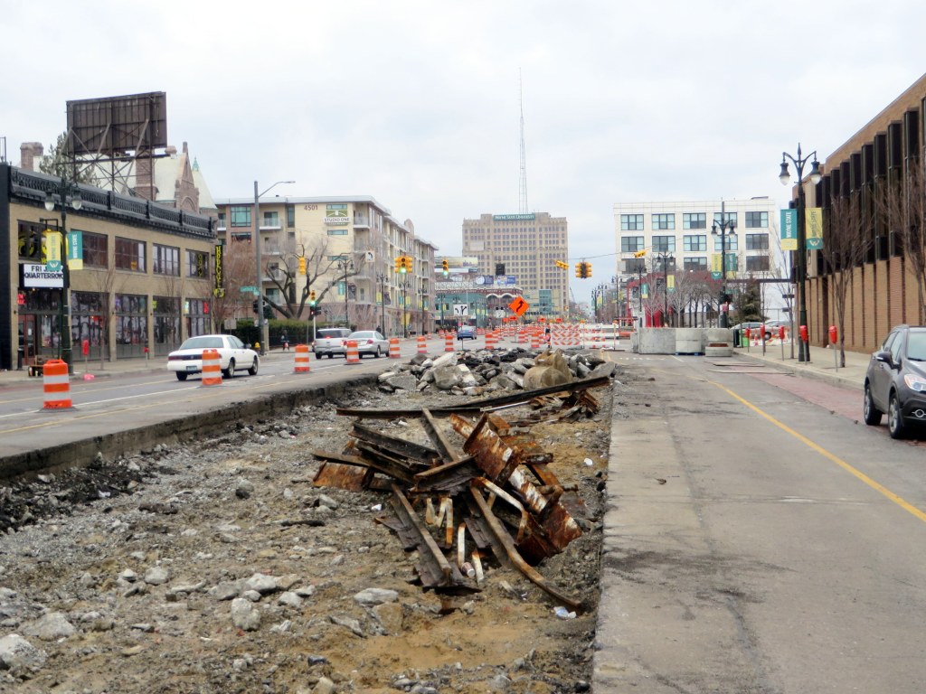
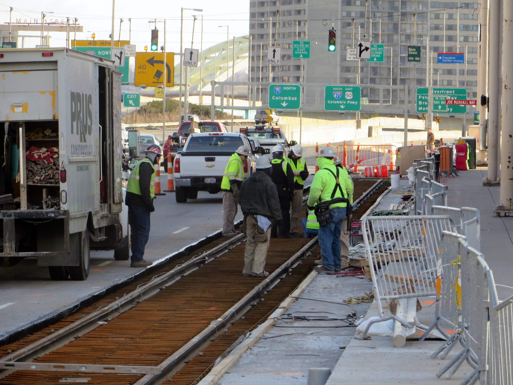
Former DSR tracks, last used in 1956, are removed as construction progresses on the M-1 streetcar, January 4, 2015Cincinnati
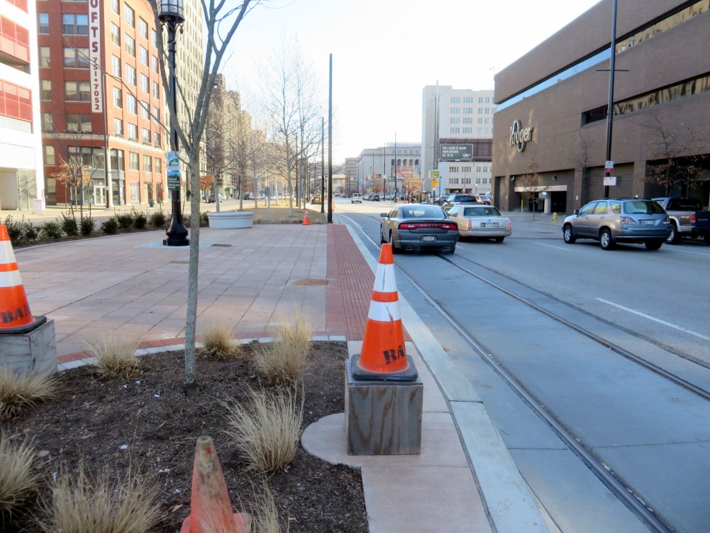
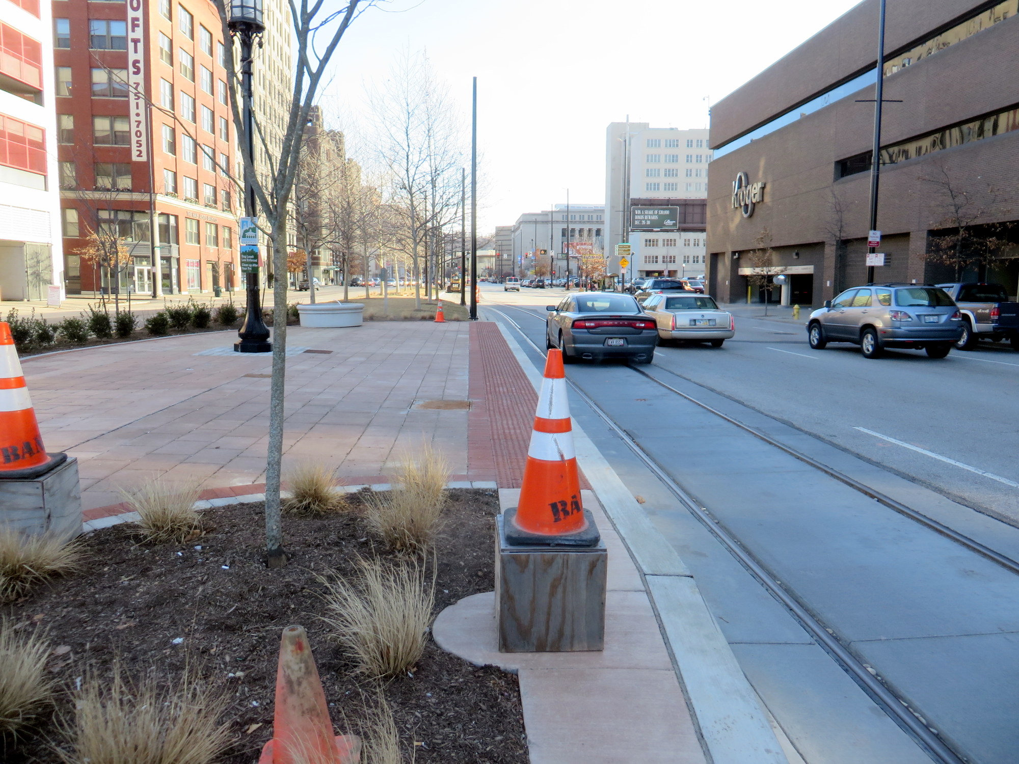
Central Boulevard, where newly laid streetcar tracks sit above the abandoned Cincinnati SubwayThe Cincinnati Streetcar, also planned to open in 2016, is further ahead in construction than Detroit. Like Detroit’s line, it was planned to link the downtown core with sports and entertainment venues, educational institutions, and gentrifying neighbourhoods. However the line, first proposed in 2007, has been mired in controversy. An unlikely alliance, conservatives and the NAACP, opposed the streetcar plan for different reasons and backed ballot initiatives to block the project. Republicans at the state level pulled funding for the project and opposed it at the federal level. (To put it very simply, conservatives were opposed to money spent on the project, while the NAACP saw the streetcar, serving the downtown and the gentrifying Over-the-Rhine district, distracting from social needs elsewhere in the city.) Until a pro-streetcar council was elected, it seemed that Cincinnati was yet again going to see a rail transit project abandoned before completion.
After the First World War, plans were drawn up for a new streetcar subway line through an abandoned canal bed on the north side of the downtown core, with a new parkway built on top (Newark and Rochester also built streetcar subways in disused canal beds; Rochester’s was abandoned in the 1950s, Newark’s City Subway is still in use as part of its light rail system.) Central Parkway was built; the subway underneath was partially completed, and when the costs to complete the line soared, and construction bonds ran out, work was abandoned. The Cincinnati Street Railway completely got rid of its streetcars in 1951. Interestingly, many of Cincinnati’s streetcars continue in service here in Toronto. The purchase of 52 PCC streetcars was the first of several streetcar acquisitions the TTC made from American cities abandoning their street railways in the 1950s.
The current route being completed is a short 5.8 kilometre (3.6 mile) long loop, utilizing Cincinnati’s one-way street grid. (Map) In effect, the first phase would be nearly half the length of Detroit’s starter line. (The extension to the university campus is now planned for a later phase, subject to funding.)
While in that city (which I’d like to explore further; I was only there overnight and in the morning), I got to see new streetcar rail be laid along the route, and poles put up for overhead wiring. But without the extension to the University of Cincinnati, and a route catering more to tourists and to downtown and Over-the-Rhine residents and bar-goers, I wonder about the utility of this one short loop.
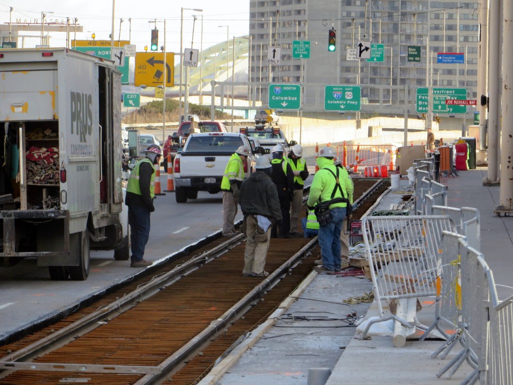 Laying track for the Cincinnati streetcar, near the Reds’ ballpark
Atlanta
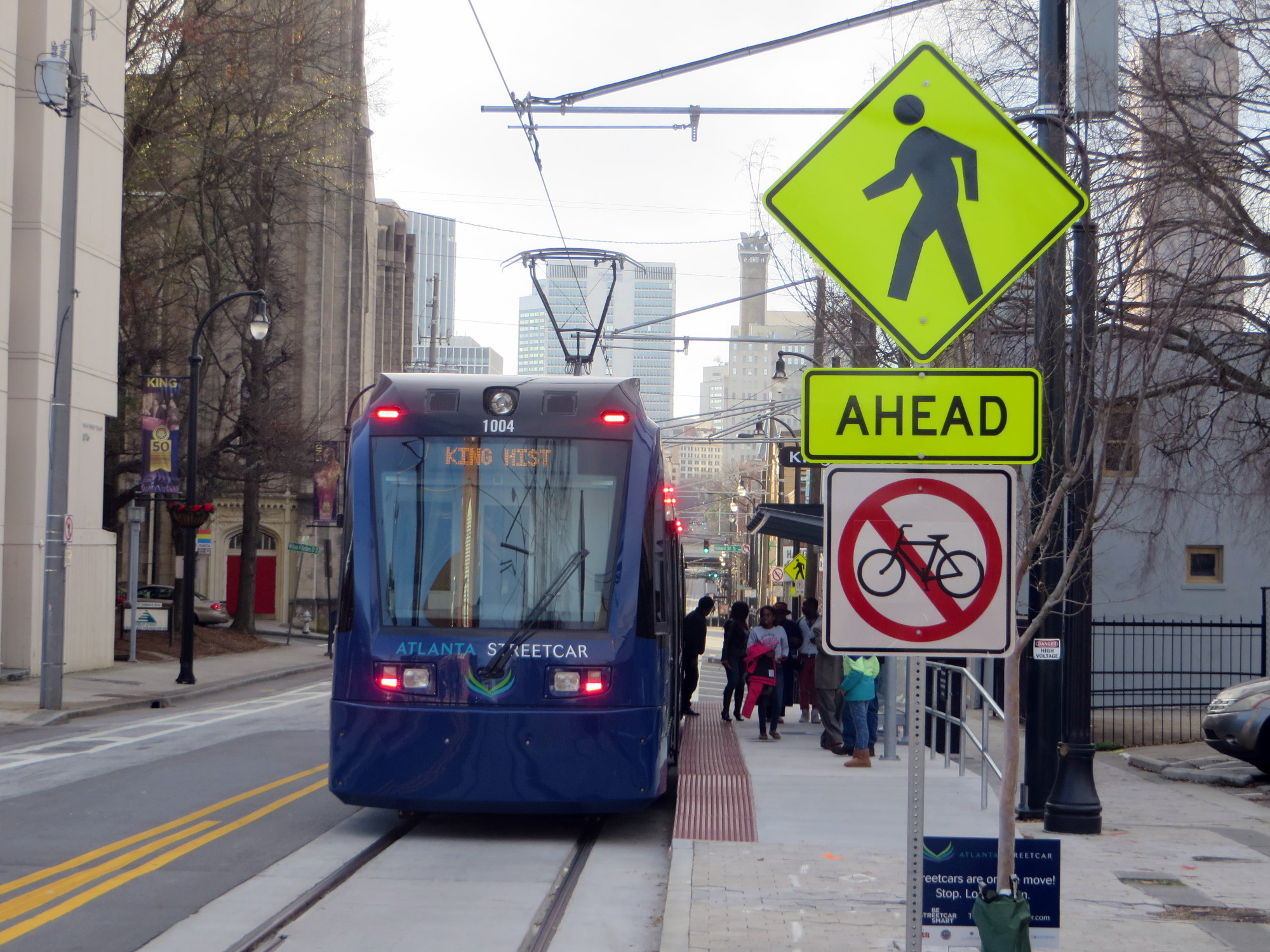
The Atlanta Streetcar opened on December 30, 2014, so I got to ride it a week after its launch. The Atlanta Streetcar, intended as the first phase of a larger system, connects downtown with the near east side, an area known as the “Old Fourth Ward” which includes the Dr. Martin Luther King Historical Site (where the civil rights leader was born, grew up and preached at his community church). The route, a one-way loop, similar to Cincinnati’s project, is only 3.7 kilometres long (2.3 miles); streetcars currently run every 10-15 minutes. For the first three months, the streetcar is free. Atlanta ripped out its streetcar system in the 1930s and after the Second World War; the last streetcar operated in the Georgia capital in 1949.
The route serves many of Atlanta’s tourist attractions, including the King Historic Site, the Centennial Olympic Park, the World of Coca-Cola and the Georgia Aquarium (Atlanta, being land-locked, hundreds of miles from the Ocean and not even on a river, is an odd place for an aquarium, but I digress) and connects with Atlanta’s rapid transit system, the MARTA subway.
But the streetcar’s short route, and infrequent schedule work against it. I found it to be very slow, and with a frequency of only every 10-15 minutes, it isn’t an efficient way of getting around the downtown core. If you miss it, you’re better off walking.
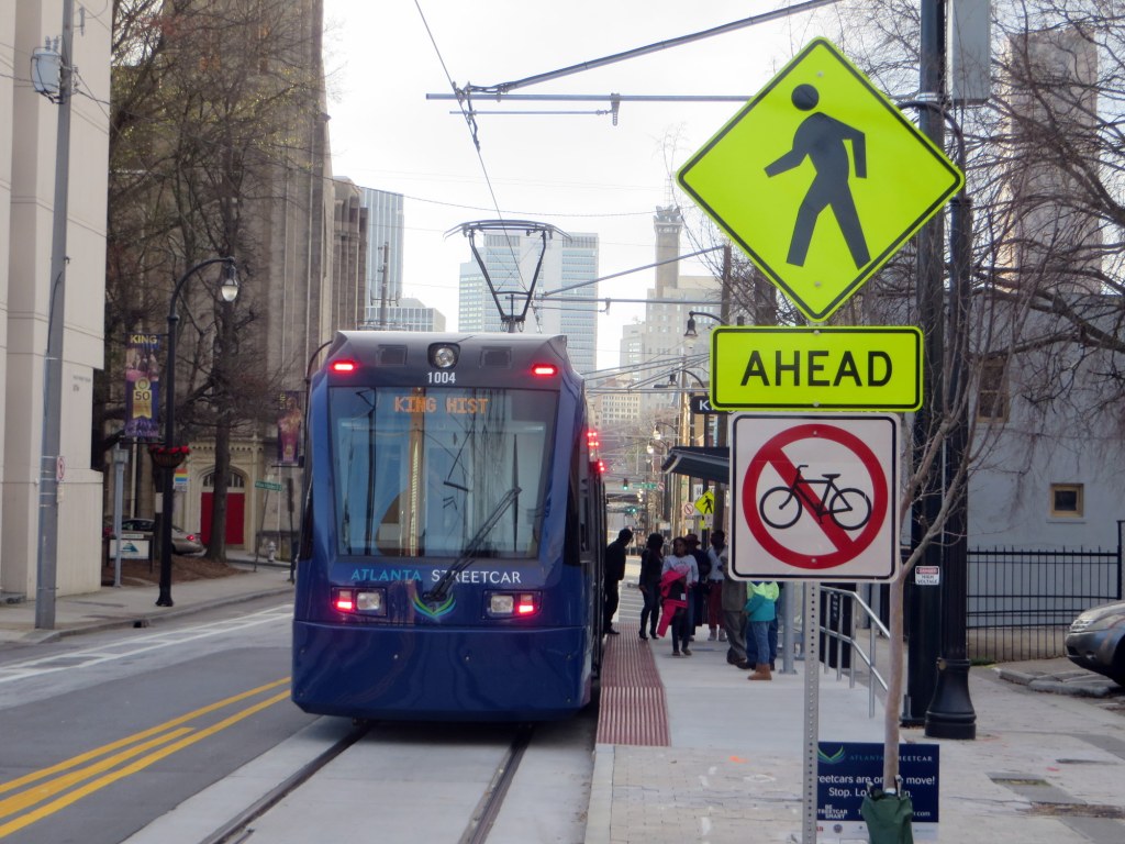
The Atlanta Streetcar in mixed traffic. Note that cyclists are banned from the streetcar’s route.Tampa
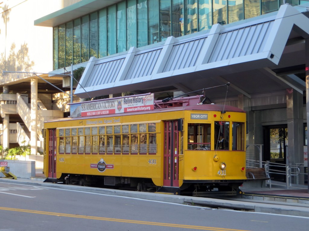
TECO Line streetcar at Whiting Station, in the south end of Tampa’s downtown coreTampa’s streetcar, opened in 2002, connects Tampa’s downtown with the historic Ybor City neighbourhood via a route along the city’s waterfront. While Tampa’s downtown is an important regional financial centre, it is rather dull, even sterile. Ybor City has emerged as the city’s nightlife and entertainment district. It has a bit of the same architectural charm one finds in the French Quarter in New Orleans.
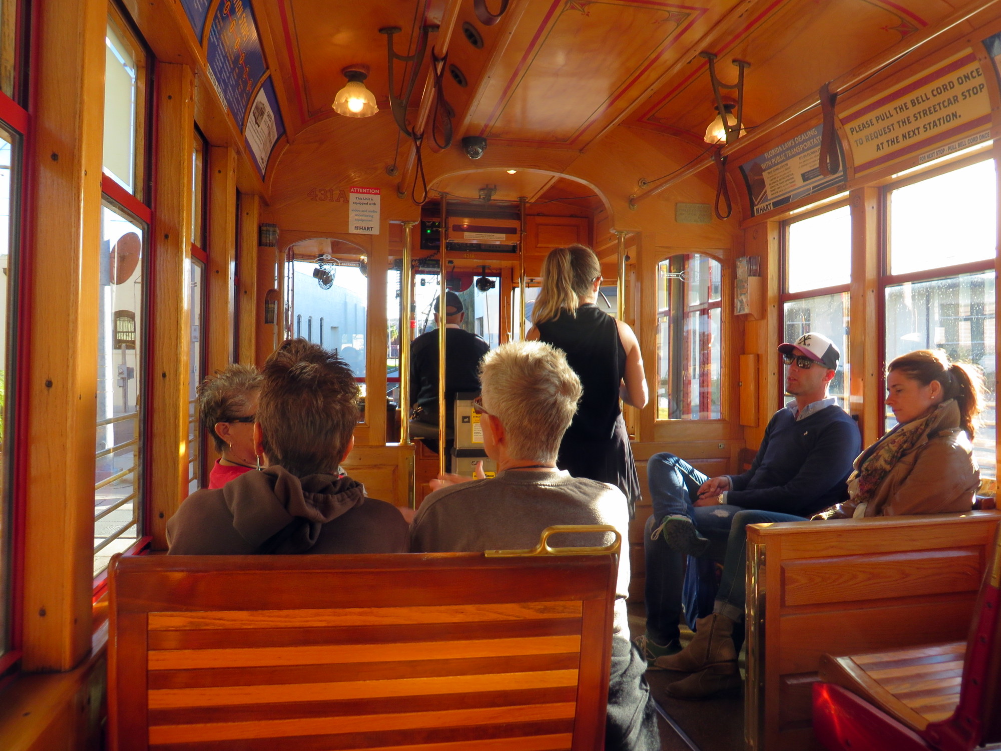
Like most early streetcar projects in the modern era, the TECO Line (named for Tampa Electric, the electric utility that helped sponsor its construction and operating partner) is a vintage streetcar system, using replica “Birney” streetcars built by the Gomaco Trolley Company in 2000. The streetcars run every 20 minutes, until about 9PM on weekdays and after midnight on Friday and Saturday nights. The line also passes the arena where the NHL’s Tampa Bay Lightning play; service is extended when there is a home game on weeknights. The TECO line is operated by the Hillsborough Area Regional Transit; fares are integrated with the rest of the local transit system.
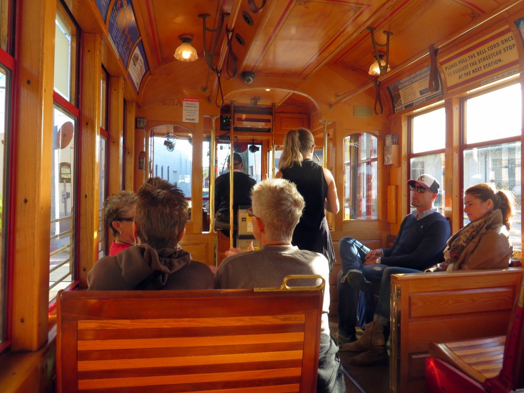
Interior of a replica streetcar on the TECO lineLike most American streetcar lines, TECO streetcar line is intended to boost development (of Tampa’s waterfront and around Ybor City) and caters to tourists; there were several European visitors on the ride into Downtown Tampa. But unfortunately, all but one streetcar in service that day were wrapped in full-body advertisements, obscuring the view out the windows. I detest transit ad-wraps; they devalue the transit agency’s branding; if they cover windows, they partially obscure the view from inside the vehicle. I feel that they disrespect paying passengers. But to wrap the signature transit fleet, especially one intended for visitors and occasional transit riders, seems wildly inappropriate.
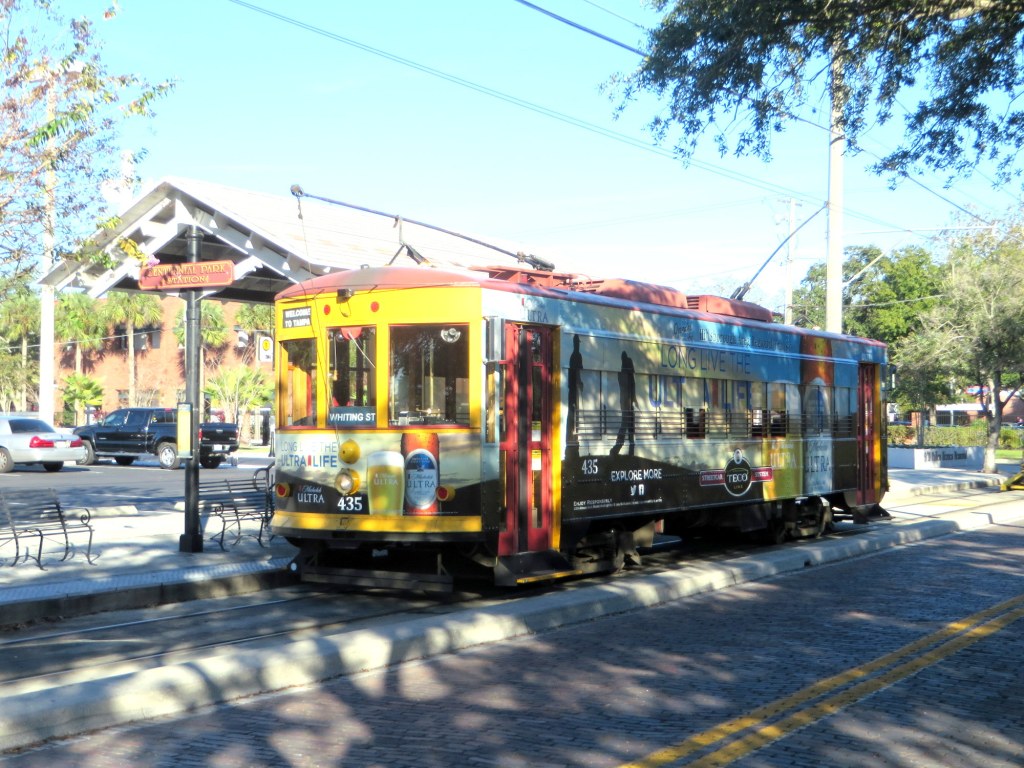 Fully wrapped TECO streetcar in Ybor City
Concluding thoughts
I’m a Torontonian, and I have loved streetcars since I was a small child. They have a certain “magic” that buses simply don’t have. Here in Toronto, and San Francisco, Philadelphia, Melbourne and many cities in Europe, streetcars/trams are an essential part of the transit network. Following Portland’s lead, the new modern streetcar lines being built across the United States (Washington, Milwaukee, and Kansas City are also building new streetcar lines) are looking to rail transit to promote mobility and economic growth in specific parts of those cities. Perhaps the small starter lines being built now will grow into large networks.
It’s likely that Atlanta’s streetcar system will grow and become more useful. Maybe Detroit’s M-1 streetcar will speed up the revitalization of the Woodward Avenue corridor and become a symbol of the Motor City’s turnaround (it does have the most utility, it seems, of the four routes I saw on this trip). I am happy to see federal money spent on transit and cities looking to building local transit projects, instead of the massive highway construction projects of the last century. But with those good feelings, I can’t help but feel a touch of skepticism as well.
-
Mapping the election: Toronto’s East End (Wards 29, 30, 31, and 32)

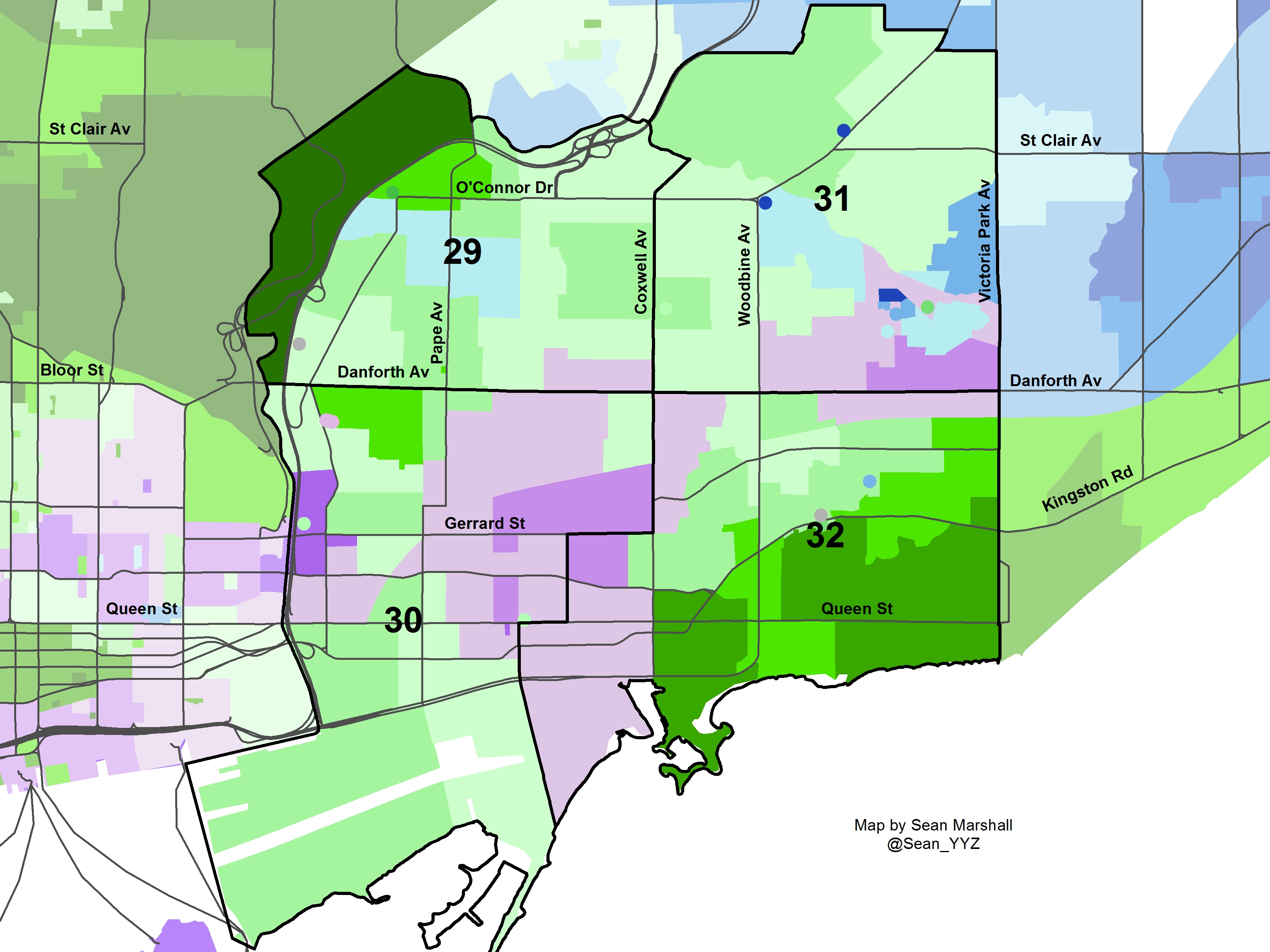
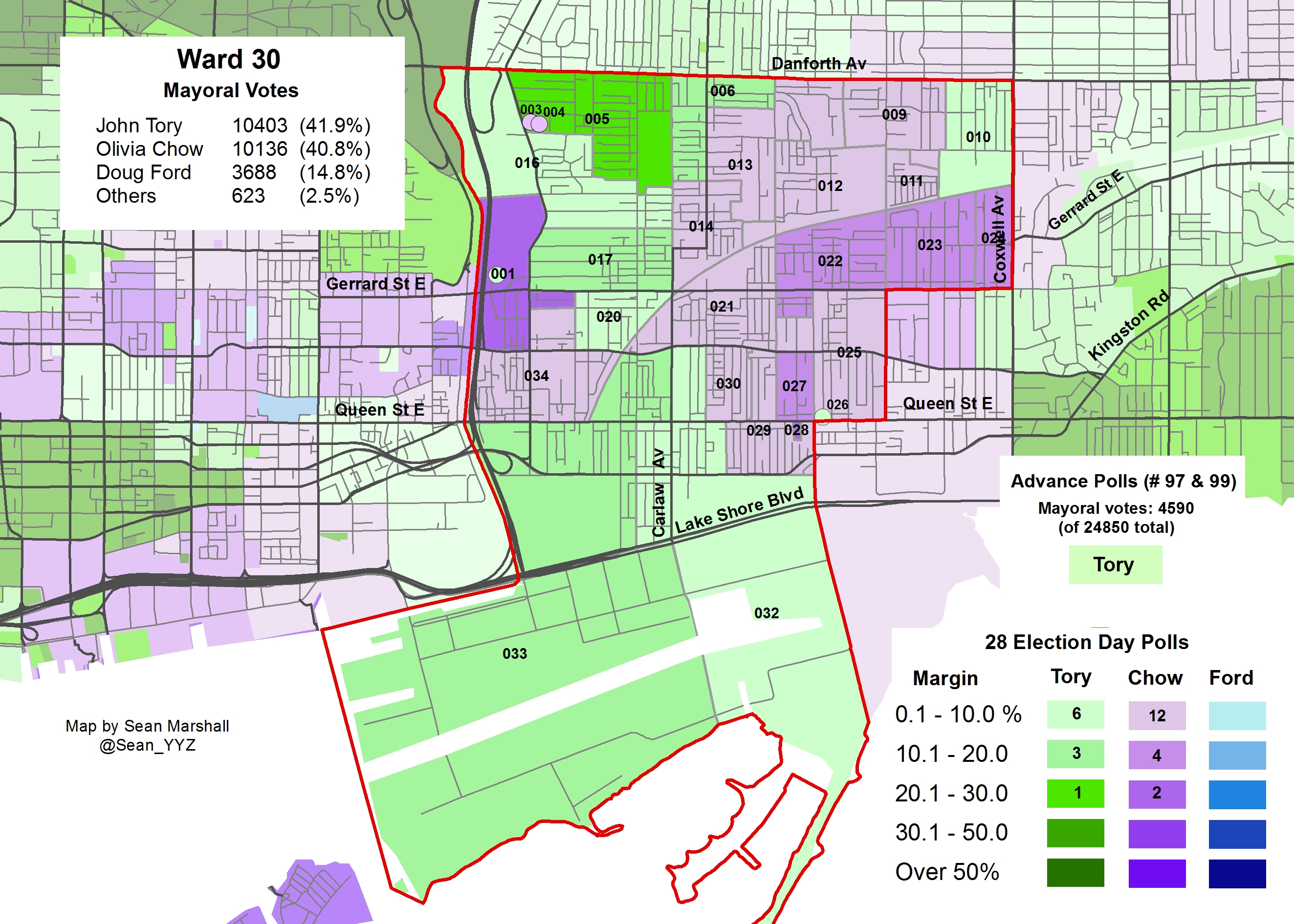
In this post, I examine the results in four east-end wards, Wards 29 and 30, Toronto-Danforth, and Wards 31 and 32, Beaches-East York. All four wards selected John Tory as their first choice as mayor (though by differing margins), and all four returned their incumbent councillors. Only in Ward 30 was there an interesting council race.
I’m about to go on a short vacation, so this will be the last of my posts looking at the poll-level results of the last Toronto municipal election for about two weeks. I still have to get to Wards 33 and 34, Don Valley East, and the 10 wards in Scarborough.
Ward 29

Poll results of the mayoral race in Ward 29Ward 29, the part of Toronto-Danforth north of Danforth Avenue, stuck with first-term left-leaning councillor Mary Fragedakis, who won every poll. Fragedakis won in 2010, beating right-leaning candidate Jane Pitfield with 41.8% of the vote to Pitfield’s 27.9%. Pitfield, previously the councillor for Ward 26, was backed by the retiring councillor Case Ootes. In 2014, Fragedakis won 59.3% of the vote; second-place Dave Andrae took 24.7% of the vote. I did not create a map for the ward race.
John Tory came in first place in Ward 29, netting 42.1% of the vote and taking 17 of 23 polls. Olivia Chow came in second place, with 32.1% of the vote, but was the second-place candidate in nearly every poll. Doug Ford came in a distant third place, but won in four polls – all near the Pape/Cosburn intersection, where there are many mid-rise rental apartment buildings. Tory did best in Poll 001, which is isolated from the rest of the ward, separated by the Don River, Don Valley Parkway and the GO Richmond Hill corridor railway line, and really part of the Rosedale neighbourhood otherwise covered by Ward 27 (where Tory did exceedingly well).
Ward 30

Poll results of the mayoral race in Ward 30John Tory came in first place in Ward 30, but Olivia Chow came in a close second place; less than 300 votes separated the two mayoral candidates. Doug Ford came in a very distant third place, taking less than 15% of the vote and no polls. Interestingly, John Tory came in first place in the Withrow Park neighbourhood closest to Danforth Avenue, while Chow came in first place in nearly all polls east of Pape/Carlaw in Leslieville.
But more interesting was the council race. In 2010, centrist Liz West, a news broadcaster, narrowly lost to long-time incumbent Paula Fletcher. Fletcher won with only 45.4% of the vote, 259 votes ahead of West.
When author, broadcaster, and community organizer Jane Farrow, a founder of Jane’s Walk and executive assistant to Ward 33 councillor Mary-Margaret McMahon, put her name forward as a candidate, there was some backlash against her bid: why run against a strong progressive councillor? Would the vote be split, allowing the relatively right-leaning Liz West to take the seat? Though Farrow’s candidacy was supported by others on the centre and left; some residents were encouraged by her community advocacy and were looking for a fresh face on city council. (I would have been pleased with either Fletcher or Farrow representing Ward 30.)
As it turns out, Paula Fletcher, backed by the endorsements of Torontoist, NOW Magazine, the Toronto Star and the Labour Council, increased her vote share in 2014, taking 49.6% of the vote. Liz West lost votes, taking only 27.7% of the vote; Farrow came in third place with 20.0%.
The feared vote-split did not happen. Fletcher came in first place in all but one poll, where Fletcher and West tied. West came in second place in every other poll, except one, Poll 034, where Farrow came in second place.
This was the most surprising of the maps that I created so far.

Poll results of the council race in Ward 30 -
The over-simplification of the TTC’s maps
 The 192 Airport Rocket on the new TTC subway map posted in its trains
The Toronto Transit Commission (TTC) introduced a new subway map on “T-1” subway trains, the older 6-car trains used on the Sheppard Line (known as Line 4), and the Bloor-Danforth Line, now known as Line 2. I first spotted the new map a few days ago and I have a few thoughts about it.
In the latest edition of the map, found over every second set of doors, a red line representing the 192 Airport Rocket bus route was added, the first time a bus route was included on a TTC subway map. It’s a helpful reminder to passengers that a fast, frequent, affordable, and usually reliable airport transit link exists. I could quibble about the details (which makes little sense; I’d simply terminate the line at the airport icon), but it’s a great addition to the map. Now that the premium Union-Pearson Express train is about to launch, it’s an excellent time to remind customers about the TTC’s affordable airport link. (It’s worth noting that the MTA in New York City includes bus routes to LaGuardia and JFK airports on its subway maps as well.)
Another little change that I like is the removal of the word “Spadina” from the name of the Yonge-University-Spadina Line, now known as Line 1. With the subway extension to Vaughan [ugh] Metropolitan Centre due to open in 2016 (though it may end up being 2017), Line 1 will now serve all four of Toronto’s universities (not counting secondary campuses): Ryerson, OCAD University, the University of Toronto, and York University. Since the line only operates under Spadina Road for less than 2 kilometres, and will extend beyond the old Spadina Expressway alignment (now Allen Road), the shortened name makes a lot of sense.
And there’s one more great little addition to the new map: information on how to purchase your own subway map via the TTC’s website. The TTC’s slowly starting to realize the demand for transit-related merchandise; it recently began selling re-prints of old promotional posters and maps to the public via a new Shop TTC page on its website and through the new Spacing Store. An authentic subway map can be yours for $10. The new maps also emphasize the subway lines’ numbers over their names, part of a larger TTC wayfinding strategy. Numbered bullets, similar to those used in New York City, are used on new signage and maps for each subway and RT route.
 Spadina is dropped; information on how to buy your own map
Despite these changes, I feel the new map edition is still two steps forward, two steps back. For one thing, there are too many details removed. Compare it to the 2005 subway map [PDF, archived at Transit Toronto]. The 2005 map includes the station’s address (which is quite useful on Yonge, Bloor, and Danforth if looking for the closest station to a specific address), whether a paper transfer is required to connect with surface transit routes, and the locations of commuter parking lots. On the 2005 map, the international symbol of access (the blue wheelchair icon) indicates which stations in the system are fully accessible. In 2005, 22 1/2 of 69 subway and RT stations were accessible. (The 1/2 refers to Spadina Station, where the University-Spadina Line platforms are not accessible to persons using wheeled mobility devices, but the platforms for the Bloor-Danforth Subway Line 2, buses, and now, streetcars, are.)
Ten years later, in 2015, 11 additional stations were fitted with elevators, bringing the total up to 33 1/2, nearly half of the TTC’s 69 stations. The 2015 map still includes the ISA icons, but they are now smaller, located within the white dots indicating the location of each station. In the photo below (taken with an iPhone), Scarborough Centre, Kennedy, Victoria Park, and Main Street, all accessible stations, are nearly indistinguishable from other, nearby stations that are not. The ISA icons are practically illegible from any distance or to anyone with impaired vision. This is the greatest failure of the new subway map; I believe that the TTC should re-issue these subway route maps for this reason alone.

The new subway maps available on the internet and on the Ride Guide paper system map have white backgrounds (perhaps to save printer toner if one wishes to print the PDF?), but it the same flaws as the version used in the subway trains.
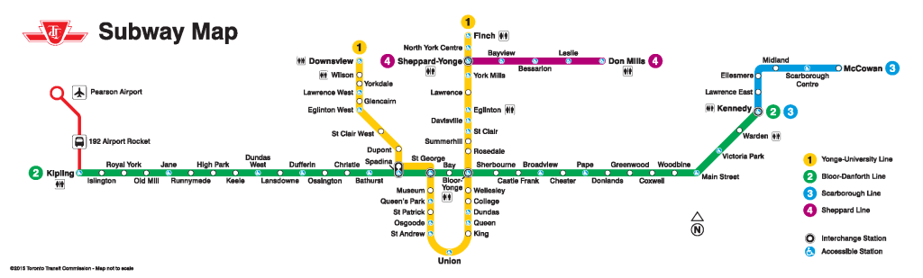
Click image for full-resolution version on the TTC’s websiteThe new, over-simplified subway route map reminds me of complaints that I had about the new TTC system map, released in mid-2014. The old system map was too large and cluttered (see the 2013 version archived at Transit-Toronto [PDF]) and was in need of a re-fresh. In the new map, the street grid is removed; as are bus routes operated by adjoining systems, such as GO Transit, Miway and York Region Transit. Landmarks are removed as well, but the addition of thick lines representing frequent-service surface routes was a nice addition. Green lines indicating express bus routes was also a great feature, though I don’t understand why frequent express routes, like the 196 York University Rocket, weren’t represented by thick lines either.
Hopefully the TTC will re-think and revise both maps in the very new feature.
-
Mapping the 2014 Toronto election: Wards 23 and 24
 Poll results of the mayoral race in Ward 23
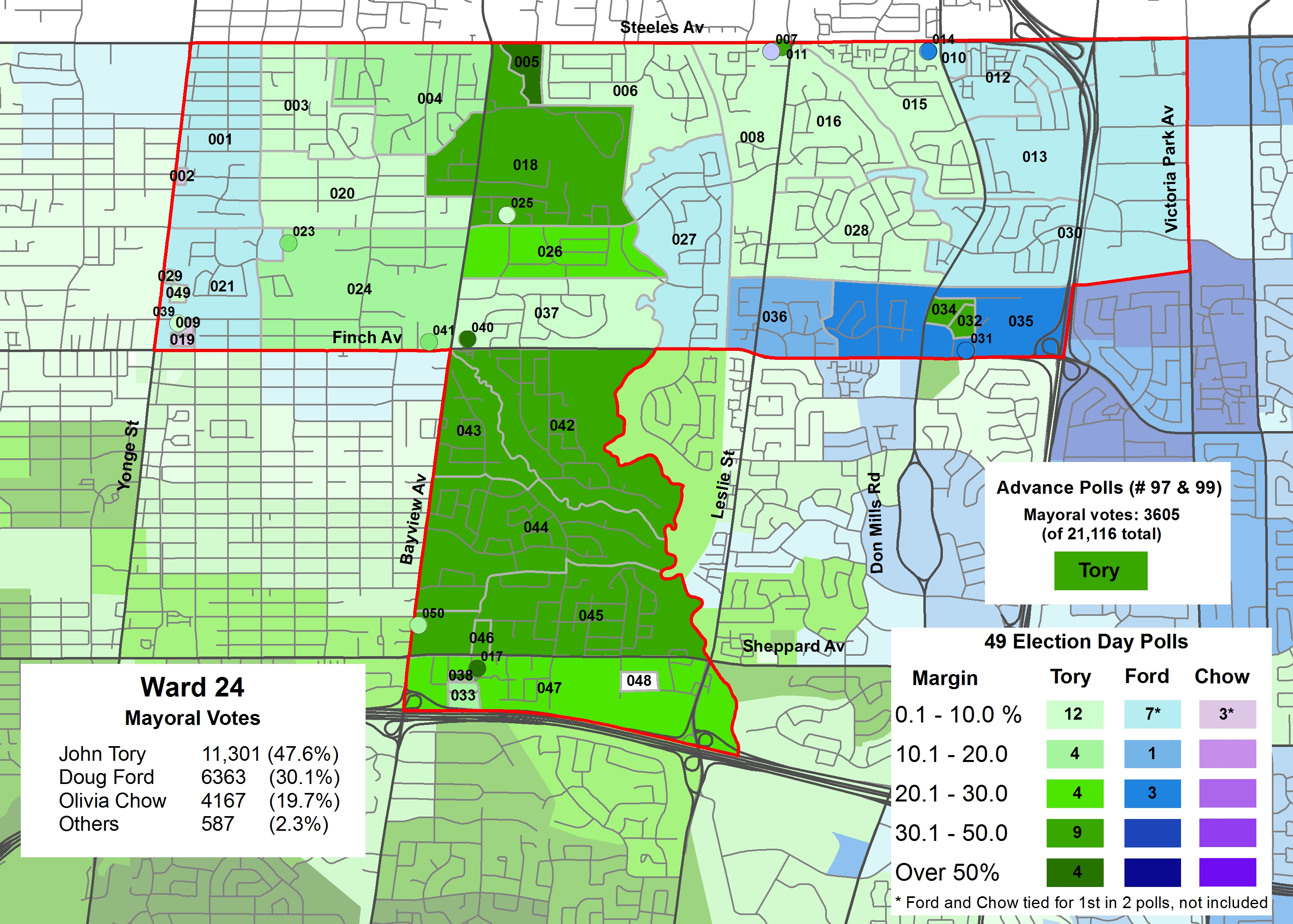
 Poll results of the mayoral race in Ward 24
There’s not a lot to say about the mayoral race in Wards 23 and 24, Willowdale. Ward 23 is Toronto’s most populated ward, with over 88,000 residents; the ward’s population grew by 11.2% in the last 5 years. The condo boom along Yonge Street between Highway 401 and north of Finch Avenue explains most of this growth. Ward 24’s population is more stable, ranging from affluent neighbourhoods near Bayview Village to low-income apartment neighbourhoods in the ward’s eastern side.
John Tory came in first place in both wards, netting 49.0% of the vote in Ward 23, and 47.6% in Ward 24. Doug Ford came in second place in both wards, Olivia Chow coming in third, with approximately 20% of the vote in both wards. Ford’s best result was in Poll 050 in Ward 23, a TCHC building. In Ward 24, Ford did the best in the Finch Avenue/Don Mills Road area.
The council races were at least more interesting, if not disappointing.
Council races
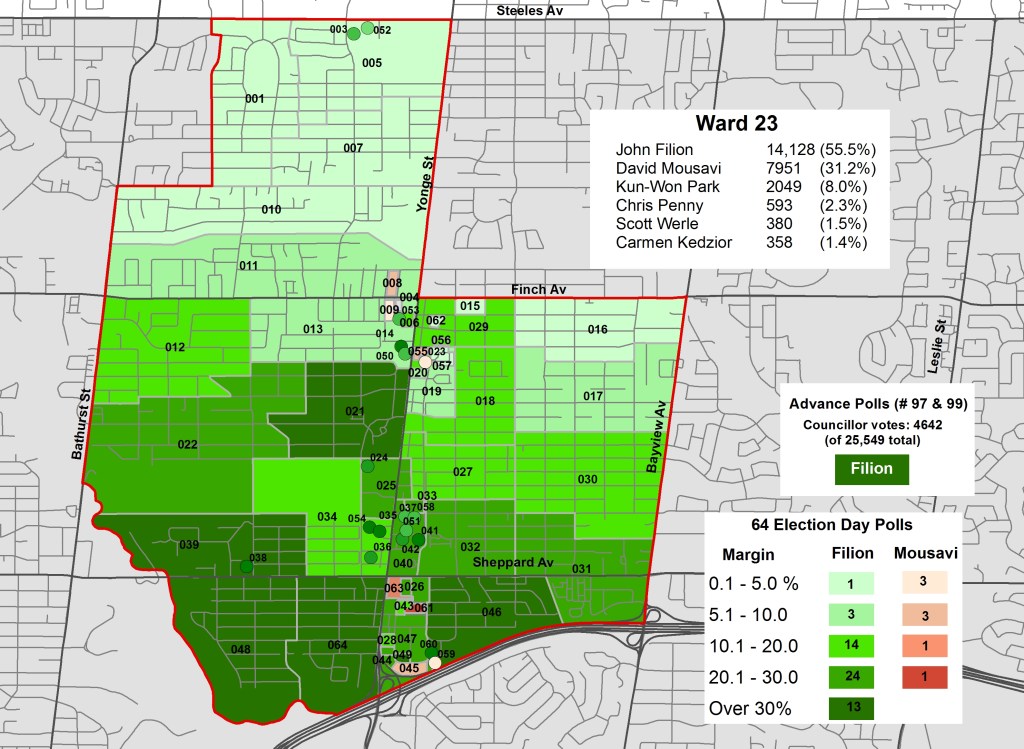 Poll results of the council race in Ward 23
In Ward 23, David Mousavi ran against long-time incumbent John Filion, a centre-left councillor who served on North York City Council before amalgamation. Mousavi ran on Filion’s right, with a platform of low tax increases, road improvements, and the extension of the Sheppard Subway to Downsview, as well as a “fresh start” for the ward.
John Filion, who was the Chair of the Toronto Board of Health (and champion of the disastrous “A La Cart” food vending program), was the first councillor to back John Tory’s campaign, surprising some election observers who expected that Filion might have backed Olivia Chow.
Filion and Mousavi found themselves in a nasty race, with both campaigns accusing each other of dirty politics. In the end, though, the incumbent won; Filion took 55.5% of the vote to Mousavi’s 31.2%. David Mousavi won 8 of 64 polls, all along the Yonge Street corridor.
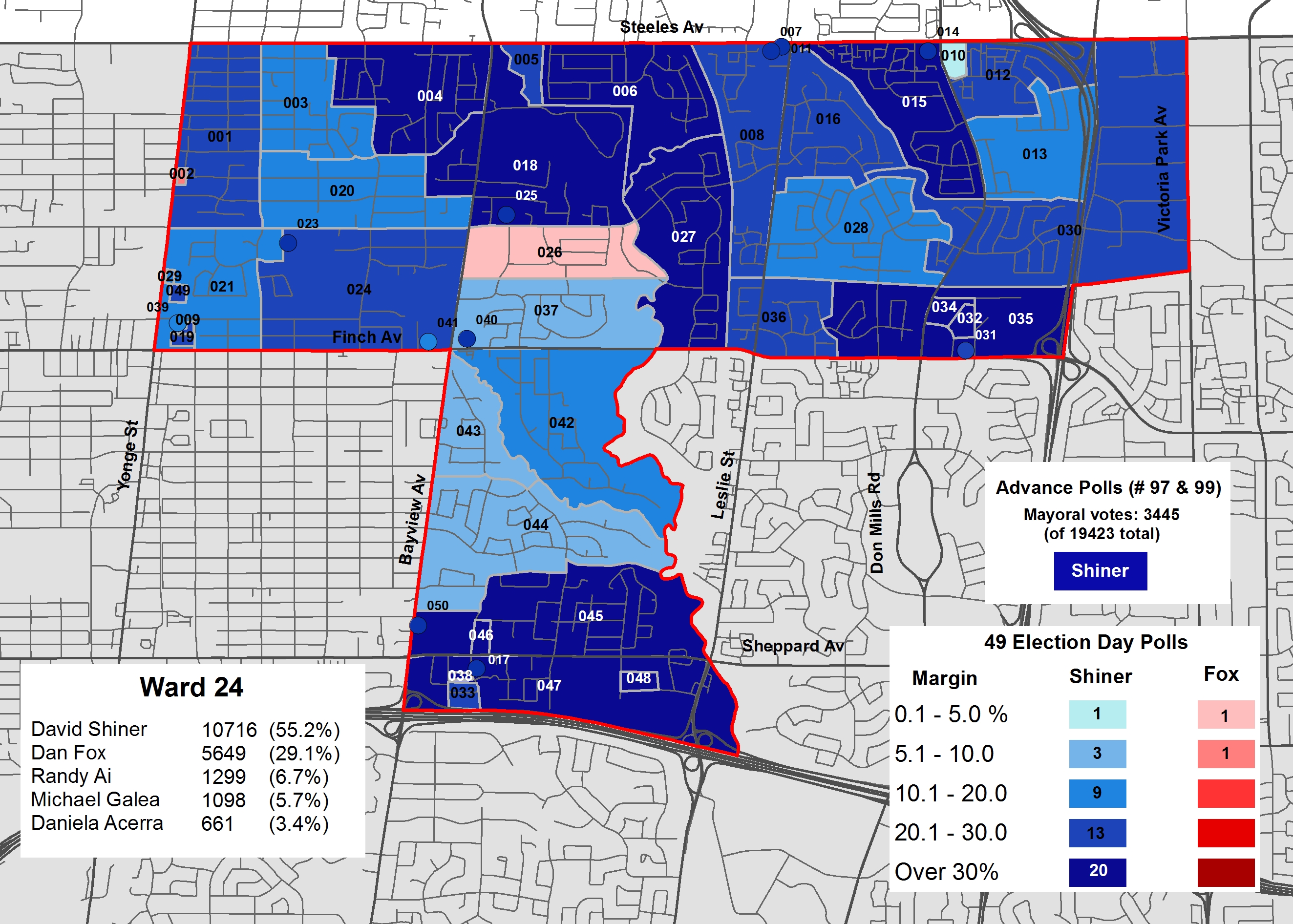
 Poll results of the council race in Ward 24
Ward 24 was, in my opinion, terribly disappointing, one of the biggest in the 2014 election.
First-time candidate Dan Fox registered in February, putting together a strong team in a bid to oust David Shiner. Fox, a community activist and federal civil servant, ran to the left of Shiner, a failed Ontario PC candidate. (I got to meet Dan Fox during the campaign, I was supportive of his run, and I hope to see him run again in 2018.)
Like Filion, Shiner first served on North York City Council; he was first elected in 1991. During Rob Ford’s term as mayor, Shiner voted with the mayor over 80% of the time, and found himself in hot water for two mini-scandals. In 2013, the Toronto Star reported that Shiner was moonlighting as a federal lobbyist for five years, on behalf of a company that dealt with the city. Also in 2013, the CBC revealed that Shiner (along with Giorgio Mammoliti, Toronto’s worst city councillor) was paying exceptionally cheap rents for an apartment in a building owned by the Greenwin-Verdiroc Group, a major city contractor.
As his custom, Shiner didn’t even bother to campaign until very late; he officially registered as a candidate on September 5.
Ward 24 was ripe for a change. Fox won the endorsement of the Toronto Star, NOW magazine and others. But like Ward 7, the people of ward 24 stuck with the incumbent, no matter how awful their councillor might be. Fox only won 2 polls, Shiner coasted to victory with 55.2% of the vote to Fox’s 29.1%.
-
A ward divided: mapping the election results in Ward 26

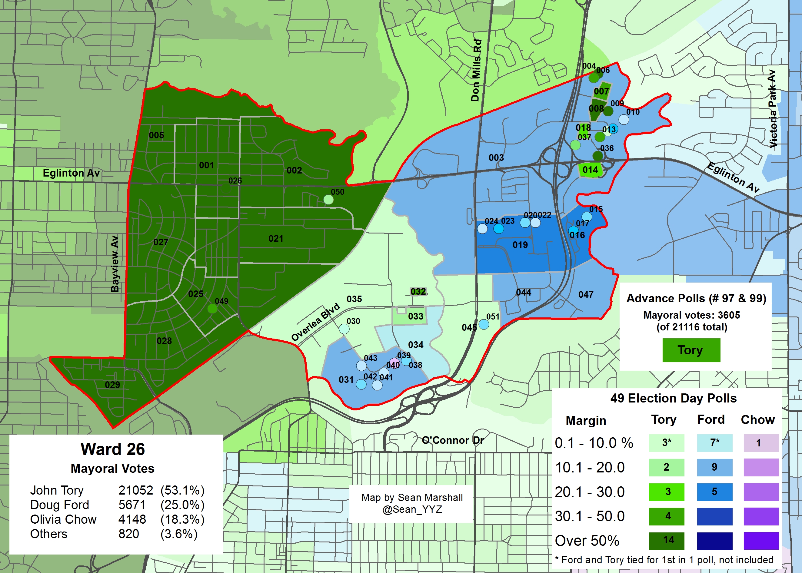
Poll results of the mayoral race in Ward 26In my last post, published on Christmas Eve, I looked at Wards 21, 22, and 25, three Midtown wards that all voted for Tory and backed their popular incumbent councillors. Unlike those three wards, Ward 26 was rather interesting.
Ward 26, half of Don Valley West (Ward 25 being the other half), was the only ward that booted out an incumbent councillor, John Parker. In retrospect, this should not have been unexpected. Parker was the only defeated sitting councillor in the last election. While Parker was a conservative-leaning councillor, I found him to be a pleasant, friendly and humourous politician in person; and a very effective deputy speaker, a welcome change from Frances Nunziata’s conduct as speaker.
(It’s a shame that of all the incumbents, some that really should have been booted out — looking at you, Wards 6, 7, and 24 — Parker was the only one to be defeated.)
Ward 26 is among the most socioeconomically and racially divided wards in Toronto. North and west of the Canadian Pacific tracks that divide the area is the affluent neighbourhood of Leaside. East of Leaside is Thorncliffe Park, a low-income, high-density apartment neighbourhood, with a very high immigrant population. Yet Thorncliffe Park has proven to be a very successful model for community engagement; it had one of the highest voter turnout rates in Toronto in the 2010 election. East of Don Mills is the similarly low-income, high-immigrant neighbourhood of Flemington Park, and to the far north-east, is the Wynford Heights-Concorde Place neighbourhood of high-rise condo and rental towers.
The socioeconomic divide is immediately apparent in the above map of the mayoral election results in Ward 26. Most Leaside polls voted for John Tory by margins of over 50%. Most polls in Flemingdon Park and Thorncliffe Park voted for Ford, but not by very high margins. In the Wynford/Concorde area, the rental towers voted for Ford, the condos for Tory. Olivia Chow won only one poll, a co-operative housing poll in Thorncliffe Park. John Tory won a majority of votes in Ward 26 (53.1%), thanks largely to his very high popularity in Leaside and Concorde Place condos, but also because Ford was not especially popular in the low-income, high-immigrant parts of the ward.
-
Mapping the 2014 Toronto election: Wards 21, 22, and 25
 Poll results of the mayoral race in Wards 21 and 22, St. Paul’s
The Christmas Eve edition in my series of posts illustrating the results of the 2014 Toronto municipal election results is definitely not the most exciting. (If you want excitement on Christmas Eve, head to Yorkdale or the Eaton Centre before they close, or go watch Die Hard.) Newly elected mayor John Tory came in first place by over 50% in each of the three wards, and three popular incumbent councillors were returned to office by landslides.
In one of my earlier posts, I looked at Ward 16, the other Midtown ward. It at least had a very interesting race for councillor; the seat was up for grabs when Karen Stintz ran for mayor.
Mayoral race
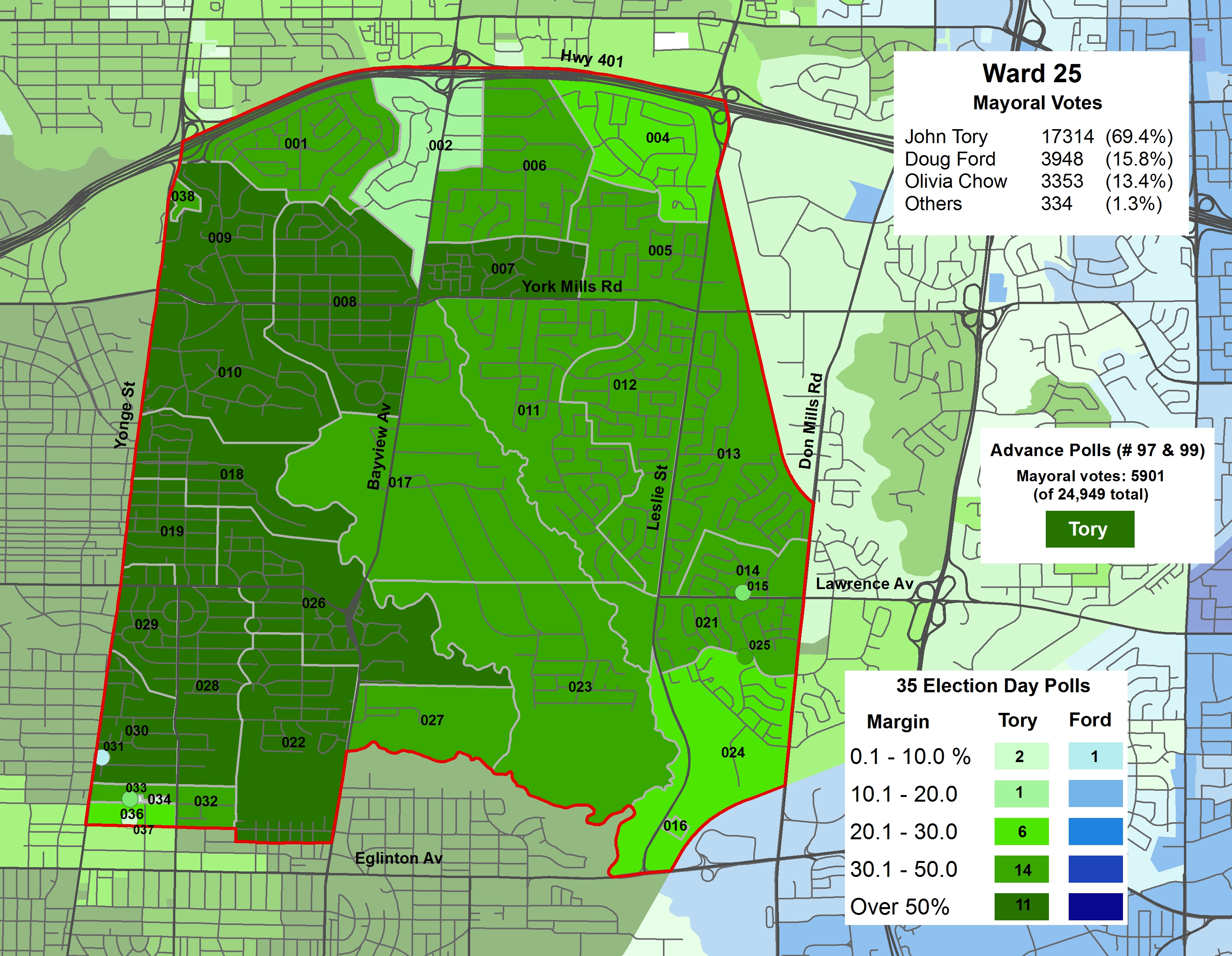
 Poll results of the mayoral race in Wards 25, Don Valley West
John Tory won all three wards by wide margins, but he was most popular in Ward 25 – Toronto’s wealthiest – winning with 69.4% of the vote there.
Olivia Chow came in first place in 11 polls in Ward 21, located mostly in Hillcrest Village and along Vaughan Road (where there are many older rental apartment buildings). Chow won one poll in Ward 22, a rental apartment building in the Davisville-Merton neighbourhood; she came in a close second place in neighbouring polls. In the affluent Forest Hill and Cedarvale neighbourhoods, Tory won polls by margins of over 50%.
Doug Ford came in first place just one poll – Poll 031 in Ward 25, a TCHC property on Yonge Street. Otherwise, Tory won by comfortable margins in most other polls in Ward 25, with the exception of the southwest corner, closest to Yonge and Eglinton, where Chow came in a close second place in several polls.
No surprises.
-
Does Scarborough need a subway extension? (No, it doesn’t.)
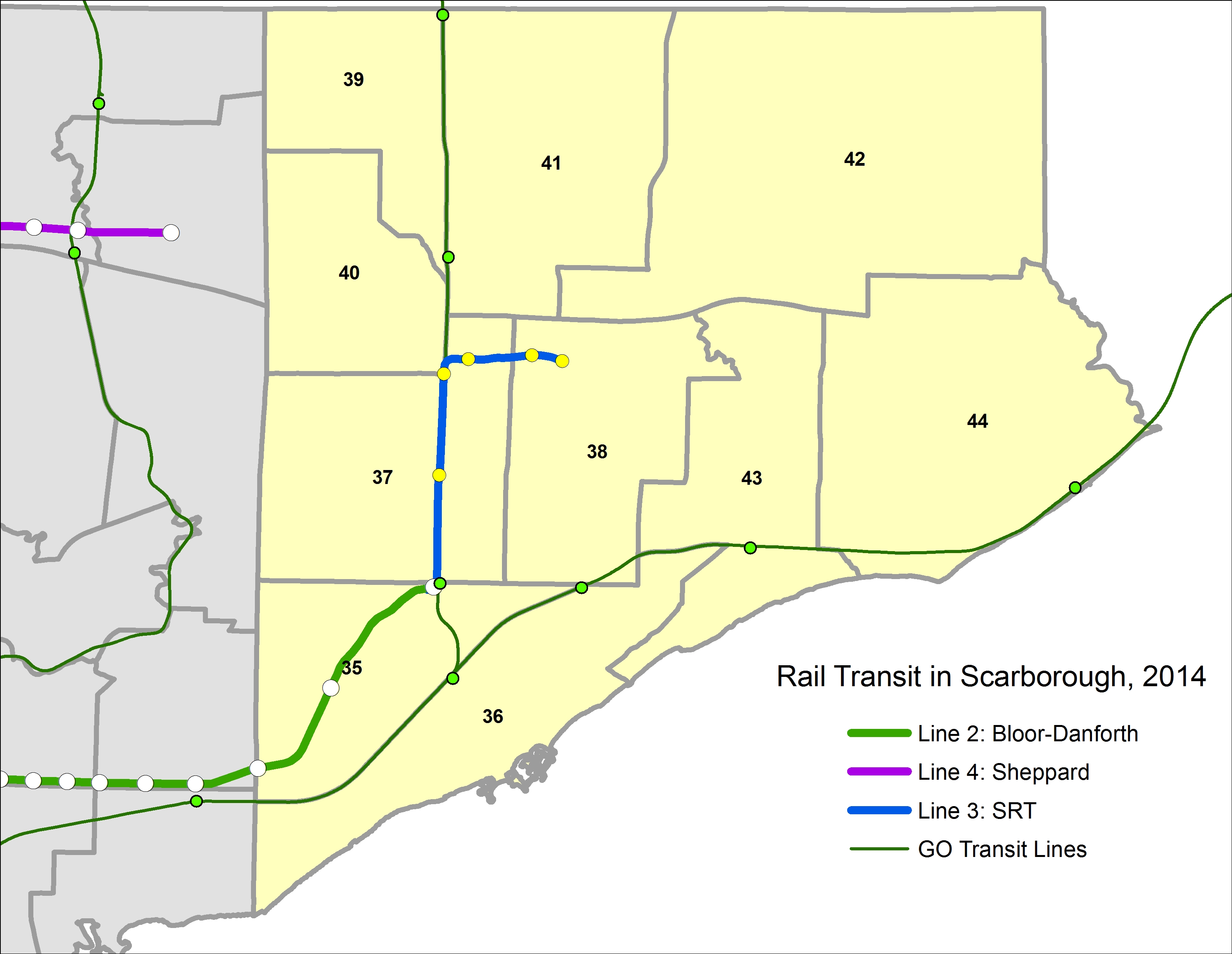
 Rail transit routes in Scarborough, 2014
The Scarborough Rapid Transit (SRT) line, opened in 1985, is in dire need of replacement. The SRT was planned as a grade-separated LRT route (here what it would have looked like), but the province pushed a new automated light metro ICTS technology. ICTS was developed by the Urban Transportation Development Corporation, then owned by the provincial government (UTDC’s technologies are now owned by Bombardier). ICTS has proven to be successful elsewhere, particularly for Vancouver’s SkyTrain, but not so much in Toronto.
The city and province originally agreed to replace the ageing SRT with an extended LRT line, which would have been fully grade-separated. It would provide a rapid, high-quality transit route similar to LRT networks in Calgary or San Diego. Repairs to the existing line and new ICTS rail cars would have been expensive and difficult. For example, a tight tunnel between Ellesmere and Midland Stations would require complete reconstruction to fit the larger cars Bombardier still produces for Vancouver.
In 2010 Rob Ford got elected on a promise of building “subways, subways, subways,” and with the province, had the fully funded, shovel-ready LRT conversion and expansion put on hold. Queen’s Park was wary of Ford’s support in those early years, and the Liberal government afraid of losing seats in Scarborough to the Conservatives. Interestingly, left-leaning councillor Glenn De Baeremaeker was one of the most vocal champions of the subway.
The alignment for the Bloor-Danforth subway extension from Kennedy Station, which has not yet been decided, would probably be routed via Eglinton Avenue, Danforth Road, and McCowan Road, with stops at McCowan and Lawrence, McCowan and Ellesmere (or closer to the Scarborough Town Centre Mall) alignment to Sheppard Avenue, and McCowan and Sheppard.
Council had the opportunity in 2013 to reverse its stance, but it unfortunately voted 26-18 to pursue the subway. Paul Ainslie (my favourite councillor in Scarborough), voted for the LRT, the only councillor from that part of Toronto to do so. In return, Mayor Rob Ford robo-called Ward 43 residents, falsely accusing the Ainslie of not consulting with his constituents when he decided to back the LRT. Ford was later forced to apologize by order of the integrity commissioner.
Ainslie has it right. Support for the subway extension, even in Scarborough, isn’t as strong as many of its politicians’ rhetoric makes it sound. Some polls even suggest that residents in Scarborough support LRT. Mayoral candidates David Soknacki (who dropped out in September) and Olivia Chow supported going back to the LRT plans, but Doug Ford and John Tory backed the subway.
So here we are. John Tory, elected mayor of Toronto, promised to continue with plans to build the Scarborough subway extension, despite its higher cost and his commitment to SmartTrack. On the campaign trail, Tory has not come out fully supporting LRT construction on Finch West or Sheppard East, two of the three pieces of the Transit City plan that are still funded. (The Eglinton-Crosstown LRT, the only Transit City route so far underway, is being built by the province through Metrolinx.)