Category: Brampton

  • Sorry, bus full: riding transit during a pandemic

    Sorry, bus full: riding transit during a pandemic

    Brampton Transit bus on route 502 Zum with “bus full” displayed

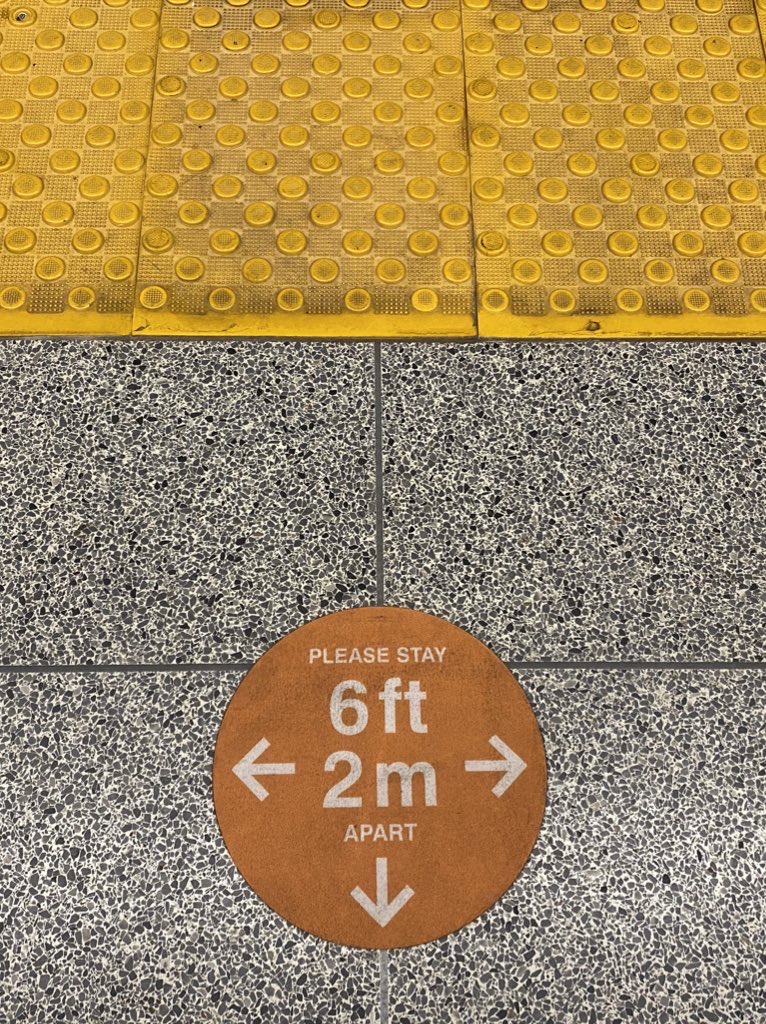
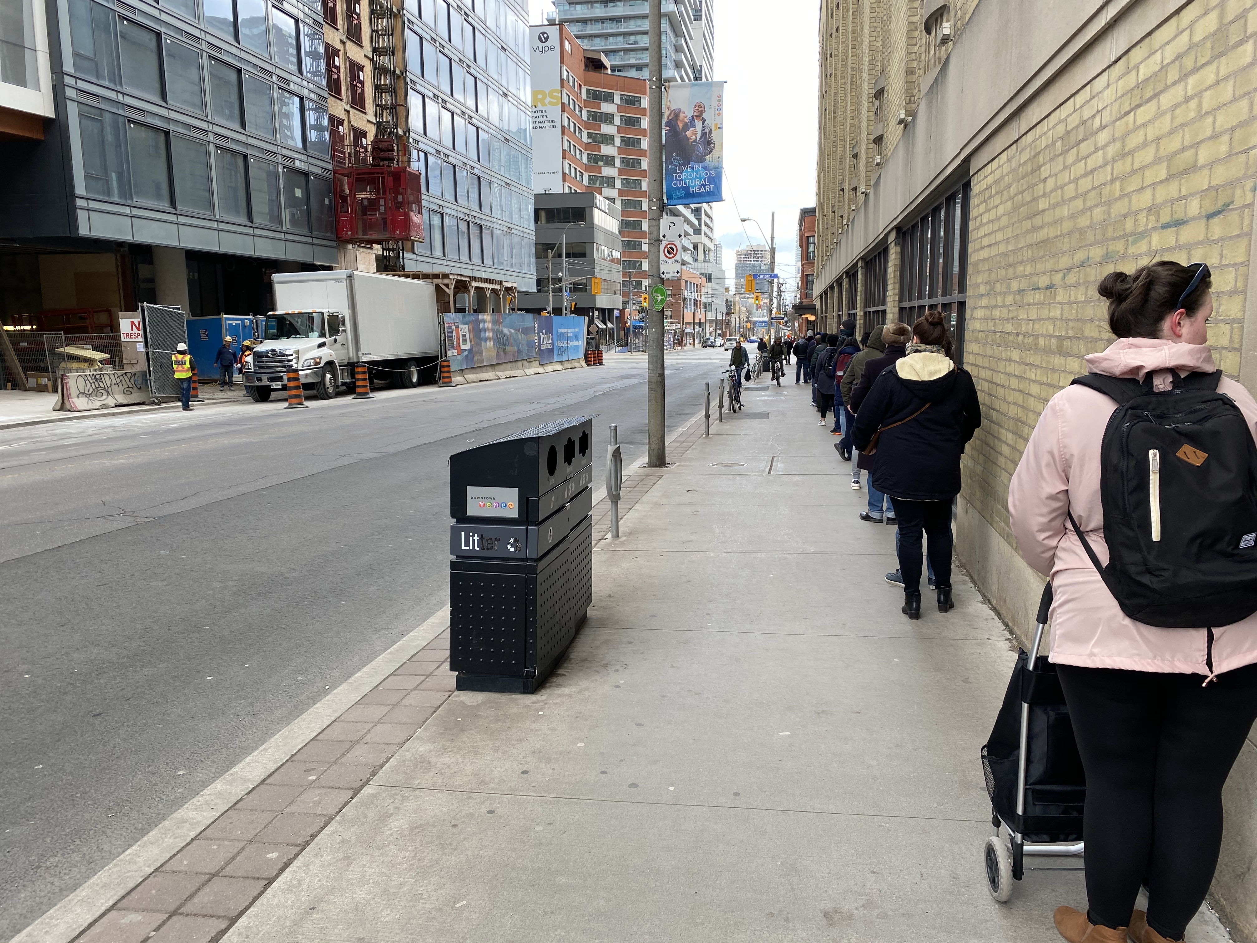
    On Thursday, I took the subway for the first time since Ontario declared a state of emergency in March. I entered Queen Station at 9:45 that morning, and rode to Wilson Station. The subway ride north was noticeably quiet, and I had a good choice of seats, even though most were marked as restricted for physical distancing.

    Empty subway train northbound on Line 1, June 11, 2020

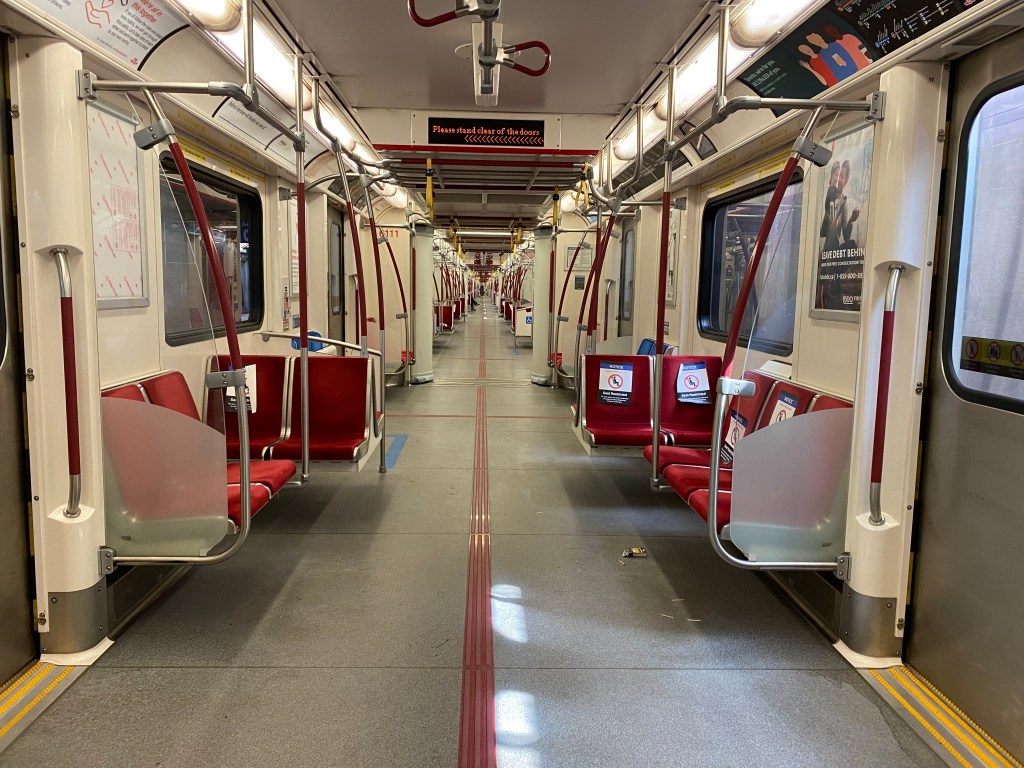
    On my return home, at 4:00 PM, the subway was busier, but still quiet enough to take a seat in the middle of the train, while just about everyone had a non-restricted seat through the downtown core. That never happened prior to March 13.

    As I am used to crowded subway trains — even on Sunday mornings — my first subway rides in months proved to be a surreal experience. Though as most passengers were wearing face coverings and keeping distance, it felt safer and more comfortable than many of my recent supermarket trips.

    Platform edge marker, Queen Station

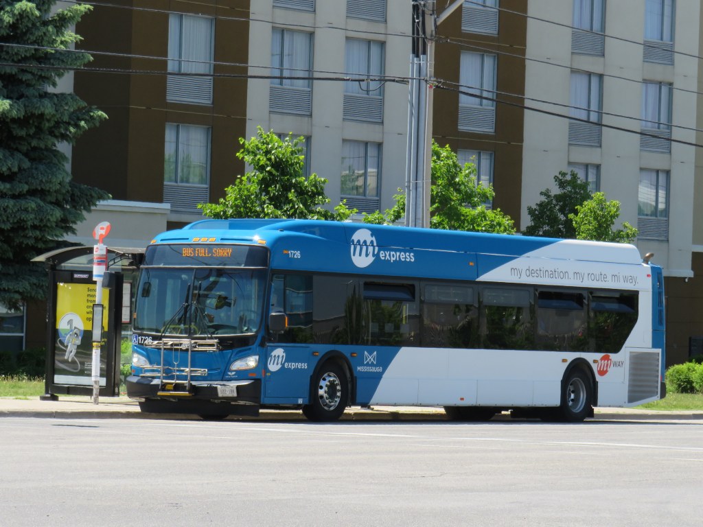
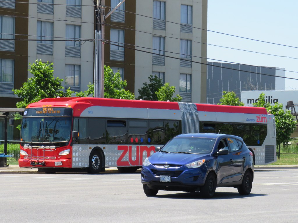
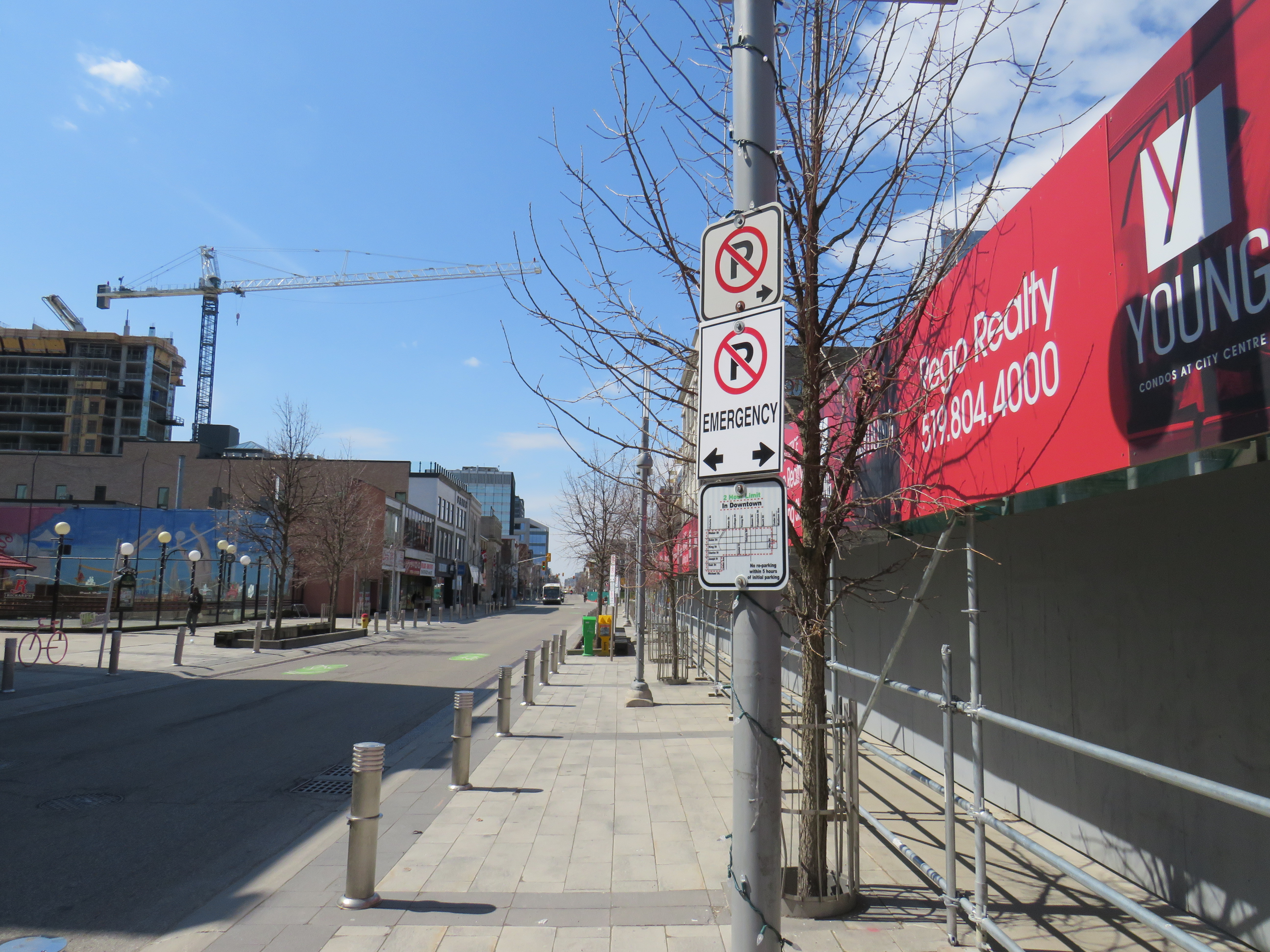
    Though subways are mostly empty, and streetcars pass through downtown with only twenty percent of their normal ridership, things are very different on the buses. In Toronto, Brampton and Mississauga, vehicles regularly bypass crowds of waiting passengers while displaying a “sorry bus full” sign.

    Miway bus full on Hurontario Street, on the same corridor as the Zum bus pictured above

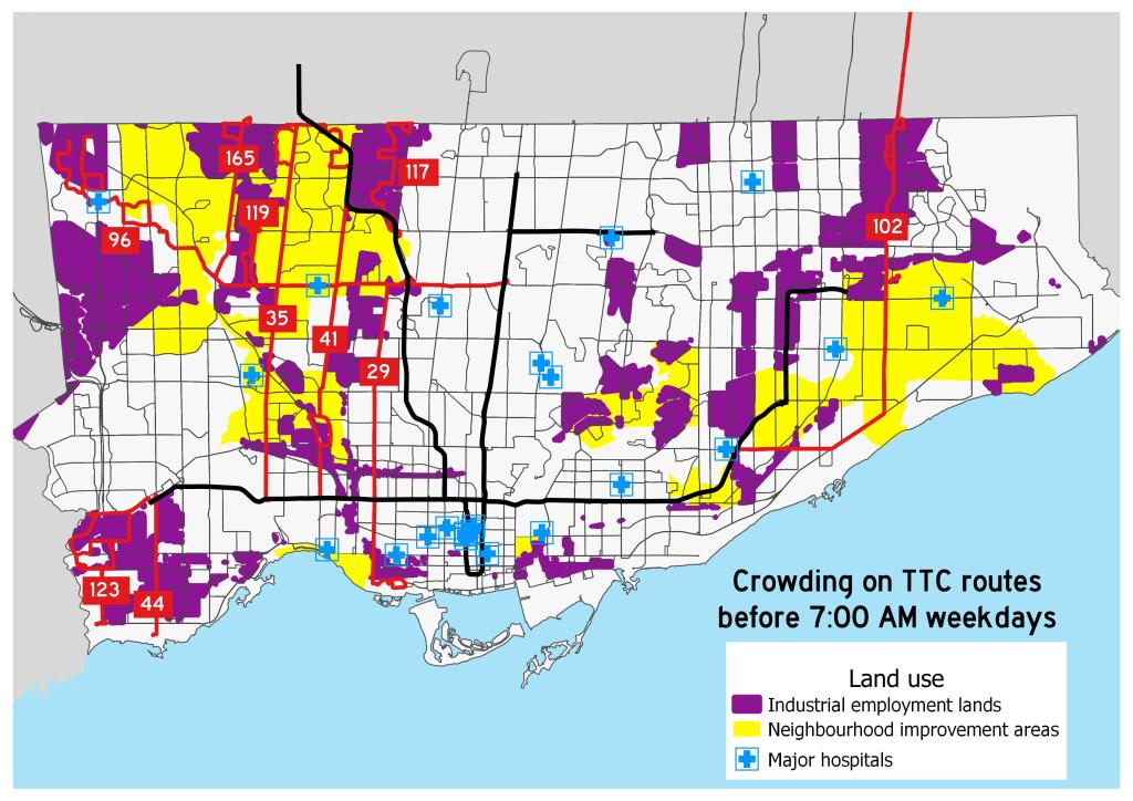
    Back in March, I mapped the TTC’s most crowded early morning routes. These ten routes were generally located in Toronto’s suburbs, serving employment lands and neighbourhoods with lower incomes and higher proportions of racialized persons. Brampton and Mississauga, which also have large food production and warehousing industries and significant immigrant and racialized populations, are experiencing similar problems with crowding.

    All buses only allow passengers to enter through the rear doors, with many seats marked restricted with paper signs similar to those on the subway. The area behind the driver is closed off as well. While the TTC expect riders to tap their Presto cards at the rear or pay by cash or ticket at a subway station, Brampton, Mississauga, and other systems are permitting free rides for now.

    A typical TTC bus contains only 33-36 passenger seats; an articulated (“bendy”) bus has 46. The TTC operators’ union instructed its members to allow only 10 customers aboard a standard bus (though the operator has discretion), and 15 aboard an articulated bus. Transporting that few people on each bus is unsustainable, and with tens of thousands of essential workers relying on the TTC to get to work — many of those jobs difficult and poorly-paying — it’s yet another inequity laid bare by this pandemic.

    Crowding on ten TTC bus routes in late March 2020

    With loosening restrictions, the demand for transit has already begun to increase. By early July, local transit agencies will require all passengers to wear masks or face coverings. At the same time, passengers will be directed to enter buses through the front doors, while reinstating mandatory fare payment.

    Meanwhile, Brampton Transit — which was operating on a modified weekend schedule since March — is restoring some of its weekday service on Monday June 15 to meet re-surging demand, while Mississauga increased service levels on June 1. Brampton, Mississauga and Toronto will require masks or face coverings on transit starting July 2.

    While Brampton plans to hand out 100,000 free non-medical masks to its transit users, the TTC plans to give out one million disposable masks, specifically targeting lower-income neighbourhoods where transit demand remains high.

    Poster in the TTC subway with instructions on how to make a no-sew fabric face covering.

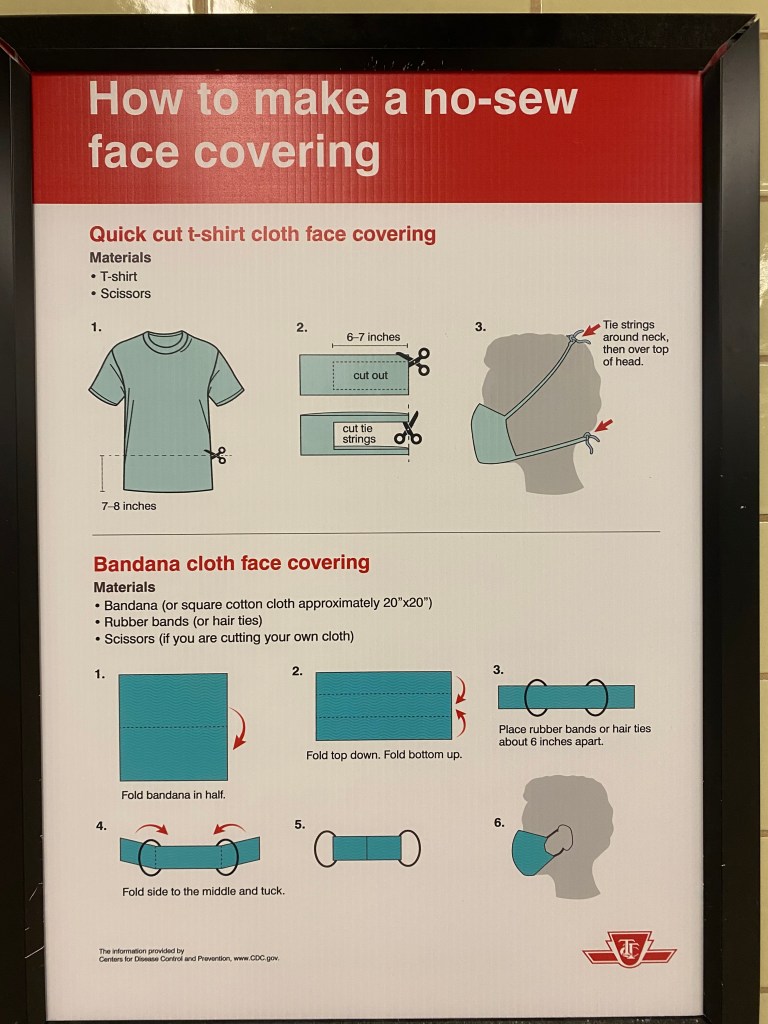
    Front-door boarding and mandatory mask use will help with some of the capacity issues on buses. Offering free masks is a welcome acknowledgement that many who have taken transit may not have money or time to purchase or make their own face coverings. (The TTC has instructions on how to make rudimentary masks posted in subway stations.)

    Even then, bus capacity will continue to be limited to ensure physical distancing, and buses will likely still pass by crowds of waiting customers.

    While central Toronto benefits from walkable neighbourhoods, existing and new cycling infrastructure, and subways and streetcars with more capacity to spare, suburban residents will still have to rely on buses. Though I see mandatory mask use as a necessary step towards mitigating the risk of viral transmission, I fear it may not be enough for those who work at hospitals and clinics, food plants and warehouses, and grocery stores, restaurants, nursing homes, and daycares.

    Bus riders deserve better.

  • Room to share: How cities can make physical distancing work

    Room to share: How cities can make physical distancing work

    IMG_8405
    Blackfriars Bridge open to pedestrians and cyclists in London, Ontario

    For my latest TVO article, I spoke with Councillor Shawn Menard in Ottawa, Councillor Rowena Santos in Brampton, and Ryerson University epidemiologist Anne Harris about how cities in Ontario are reallocating road space for pedestrians and cyclists during the ongoing COVID-19 pandemic, or why they may be hesitant to do so.

    In Brampton, five kilometres of new bike lanes, proposed in that city’s new transportation plan, were quickly approved as part of its response to COVID-19. This benefits both pedestrians and cyclists by reducing conflicts on sidewalks, reducing congestion on city paths, and recognizing that cycling is an increasingly important mode of transportation.

    IMG_8499-001
    Cyclists on Howden Boulevard, Brampton

    In Ottawa, despite resistance from the the mayor and council, Shawn Menard, who represents an urban ward just south of Parliament Hill, was able to temporarily close two lanes of traffic on a narrow bridge on a major retail street, and worked with the National Capital Commission to re-allocate a section of parkway for active transportation.

    Meanwhile in Toronto, the mayor and medical officer of health were resistant to increasing calls for sidewalk expansions in congested urban areas, including where queues formed to enter grocery stores, pharmacies, hardware stores, and LCBO outlets.

    This was one of my favourite articles I have written so far. 


    Loblaws queue on Church Street
    Queue on Church Street at Carlton to enter Loblaws supermarket

    With Walk Toronto, I have been involved with pushing the City of Toronto to take action, especially in pinch points where store queues, construction barriers, and other obstructions have made it difficult — if not impossible — to safely practice physical distancing when walking or cycling for essential purposes, or even getting a little bit of fresh air or light exercise in dense urban areas.

    The good news is that ten problem areas — including the intersection of Carlton and Church — have finally been identified for curb lane closures, with potentially more on the way. This is a timid first step, made after weeks of advocacy, but it is welcome.

  • How to reimagine our streets during a pandemic

    How to reimagine our streets during a pandemic

    Queen Street West, late March 2020
    Nobody’s going to be flocking to the streets during a pandemic

    In an interview with local news station CP24, Mayor John Tory said that the city was considering implementing one-way directional traffic on city sidewalks as part of a response to COVID-19. This idea was considered as a measure to ensure physical distancing on Toronto’s sidewalks.

    The mayor, however, does not support the alternate solution of increasing the amount of road space given to pedestrians and cyclists. With traffic on major routes such as Yonge, Queen, and Bloor reduced, and most businesses closed, it would be easy to provide additional space for pedestrians without causing traffic congestion. According to the mayor, “it could have the unintended effect of attracting more pedestrians to busy areas, something the city is actively trying to discourage right now.”

    That’s ridiculous.

    With businesses closed, no patios to linger at, and no programming (unlike at any other street closure, whether it be Taste of the Danforth, Open Streets, Pride Week, or Buskerfest), pedestrians will not be attracted to linger and crowd sidewalks in dense urban neighbourhoods. However, they will be able to walk to work, get to essential services, exercise the dog, or get some fresh air, without having to dodge other people or sidewalk barriers, such as construction scaffolding.

    Furthermore, enforcing one-way sidewalks — the city’s only other idea — would be extremely difficult to enforce. It would  only increase the distance pedestrians would have to walk to get to work or essential services. It would go against centuries of practice, and it would encourage less-safe midblock crossings. It would be especially cumbersome for seniors and pedestrians with disabilities. 

    While Toronto continues to do nothing to protect vulnerable road users during a pandemic, other cities — including Montreal, New York, Vancouver, Denver, and Oakland— have closed entire roads to better serve pedestrians and cyclists in parks and dense urban areas. Closer to home, Kitchener and Brampton have also taken steps to to assist active transportation during this unprecedented time.

    IMG_8335-001
    King Street, Downtown Kitchener

    A decade ago, King Street in Downtown Kitchener was reconstructed with new lighting, street furniture, trees, and a rolled curb separating the narrow street with sidewalk and street parking and loading areas, which were separated from the pedestrian area by removable bollards. As a response to COVID-19, most of the parking spots were blocked off, with the bollards moved towards the roadways, quickly and easily expanding the pedestrian zone. With new residential development in Downtown Kitchener, several portions of the regular sidewalk were covered with scaffolding. The widened pedestrian clearway made it easy and safe to get around the barriers, allowing pedestrians to practice physical distancing.

    IMG_8333-001
    Bollards moved close to the street, and parking banned. It’s much easier to get around the construction scaffolding.

    Meanwhile, in Brampton, where sidewalk crowding isn’t usually a problem, the city government went ahead with a plan to close the right lanes of Howden Boulevard and Vodden Street — four-lane collector roads through residential areas — to install temporary bike lanes. This will provide a five-kilometre bikeway across the city between Etobicoke Creek and Chinguacousy Park, crossing Highway 410 at a safe location.

    Installing temporary lanes makes it easier in the future to make the lanes permanent — Vodden and Howden could use road diets after all — which could connect three north-south ravine paths and connect Downtown Brampton with Bramalea City Centre. City Council — including Mayor Patrick Brown — is committed to improving the city’s rather poor active transportation infrastructure.

    Brampton Temp Bike Lanes
    Temporary bike lanes coming to Howden Blvd. in Brampton

    While Toronto continues to drag its heels on providing safe spaces for its residents to walk and bike while being physically distant, its peer cities — and even one of its suburbs, are leading. One can only speculate about the reasoning behind Mayor Tory’s reluctance to do more.

  • Some love for Ontario’s municipal flags

    Some love for Ontario’s municipal flags

    Flag of TorontoThe flag of the City of Toronto, designed by Renato De Santis, is an example of a very good civic flag

    I was in Orillia last week, mainly to check out the new Simcoe County Lynx bus system. While there, the flag flying from the Opera House (formerly the city hall) caught my attention. Most municipal flags are boring, usually consisting of the town or city’s coat of arms, shield, or logo on a plain background.

    Orillia municipal flag, with a yellow sun in the middle

    But Orillia’s flag is different. It has waving blue and white waves, with two green triangles facing the centre, and a bright yellow sun in the middle. The symbolism wasn’t difficult to figure out: the city’s position on the narrows between Lake Simcoe and Lake Couchiching, with the sun being a nod to Orillia author Stephen Leacock’s Sunshine Sketches of a Little Town, a light, humourous collection of short stories about the denizens of Mariposa, a thinly-veiled fictionalization of Orillia.

    Yet Canadian cities that boast populations twenty or thirty times that of Orillia can’t boast having such a fine flag.

    For the most part, we don’t think about state, provincial, and municipal flags, and that’s a pity. In the few cities that have an unique and powerful flag, they have become part of that city’s iconography. Unfortunately, though Toronto does have a very good civic flag, we don’t fly it like it should.

    According to the North American Vexillological Association, there are five principles for creating a good flag:

    • Keep it simple — so simple, it can be drawn by a child from memory
    • Use meaningful symbolism
    • Use two or three basic colours
    • Never use lettering or seals
    • Be distinctive or be related

    Canada’s flag, adopted in 1965, adheres to these principles perfectly. It uses just two basic colours: red and white. With a large red maple leaf in the middle, it’s easily recognizable around the world. While a child might not get the eleven-point maple leaf exactly right, it’s otherwise easy to draw from memory.

    There are, of course, exceptions to these principles.

    Maryland’s complicated state flag, based on the coat of arms of colony founder Cecil Calvert, Lord Baltimore, is distinctive and popular, nearly as common as the US flag. California’s state flag is emblazoned with the words “California Republic” but it has significant historical meaning. The flag of South Africa, adopted in 1994, has six colours, but by merging the Pan-African colours of the African National Congress with the red white and blue of Britain and the Netherlands, it represents unity in the post-apartheid era.

    Flags of Maryland, California, and South Africa, notable exceptions to the rules

    For the most part, famous and great civic flags adhere to these principles. The flags of Amsterdam, Berlin, Chicago, and Tokyo all stand out. In Chicago and Amsterdam, these flags are proudly flown from private homes and watercraft, found on t-shirts and souvenirs, and well known around the world. The bear from Berlin’s flag is almost as popular as the Ampelmännchen. Though Amsterdam’s flag’s origins go back centuries (the “x”s are actually St. Andrew’s crosses), it looks bad-ass, and on-brand for a city famous for its tolerance.

    Great civic flags: Amsterdam, Berlin, Chicago, Tokyo

    Compared to the great examples above, Ontario’s provincial flag is just bad. Compare the provincial red ensign with the flag of Manitoba, and then compare it to the Franco-Ontarien flag.

    The Ontario and Manitoba flags, British red ensigns defaced with the provincial shields, were only adopted in 1965 and 1966 as conservative reactions to the new flag of Canada. The two flags are difficult to tell apart from a distance, and they both contain the St. George’s cross (representing England) twice: once in the union flag in the canton, and again in the shield. There’s very little Ontario to be found. (At least the Manitoba flag contains a bison, a recognizable symbol of that province.)

    Meanwhile, the Franco-Ontarien flag is immediately recognizable, with the fleur-de-lis and a stylized trillium, the provincial flower, representing the French-Canadian presence in Ontario.

    Like Orillia, there are a few other civic flags in Ontario that get it right.

    Flags of Thunder Bay, Hamilton, Ottawa, and Toronto

    Thunder Bay’s flag depicts a rising sun above Lake Superior and the Sleeping Giant, a prominent natural landmark across the water. The flag of Hamilton includes a yellow cinquefoil, the badge of the Clan of Hamilton, with a steel chain with six large links representing the steel industry and the six municipalities amalgamated into the modern city. The flag of Ottawa contains the civic logo, with the points representing waterways and the Peace Tower on Parliament Hill. Finally, the flag of Toronto has an abstract depiction of Toronto’s city hall, with a maple leaf where the council chamber sits. The two towers also make a “T.”

    It’s a shame that Toronto doesn’t make more of its simple, yet great flag.

    Unfortunately, most flags look like those used by Ontario’s third and fourth largest cities.

    Mississauga’s flag violates most of the principles listed above by including the name of the place it represents, with the addition of “incorporated 1974” at the bottom. In the middle is the civic shield, with the typical trappings: a cog representing industry, a lighthouse representing a port (Port Credit), a waterwheel, a stalk of wheat, and wings, possibly representing Pearson Airport. Though Mississauga is a proud city with its own identity, this flag doesn’t appear except in front of civic buildings.

    Brampton’s flag is just the civic shield on a white background, again with similar trappings: a bushel of wheat, a plow, a steam locomotive, and a beaver. According to the city’s website, the gold colour and castle top signify the city’s relation with the small Cumbrian town of Brampton, England. The shield dates from the small rural town before post-war growth, with only a pine tree in the middle to represent the old township of Chinguacousy it merged with. There’s no recognition of Brampton’s modern identity as a multicultural city.

    But at least they’re not as bad as the worst city flag identified by the North American Vexillological Association, that of the city of Pocatello, Idaho, which manages to include the city slogan, a trademark, and a copyright notice. After some embarrassment, the city came up with a new, much better flag.

    Old Flag of PocatelloThe former flag of Pocatello, Idaho

    It would be wonderful to see Brampton and Mississauga come up with better designs. Brampton’s new logo and slogan, Flower City, better represents the city’s history and ambitions. A pretty good flag could be made out of that.

    As for Toronto, let’s embrace our flag more. It’s a fine one and far better than the province’s. As Torontonians generally think of themselves as Canadian first, Torontonian second, and Ontarian third, perhaps we should give our municipal banner more love.

  • Why transit users shouldn’t beg to cross the street

    IMG_8372.jpg

    With consistently high ridership growth over the last few years, Brampton Transit has proven to be one of the Canada’s greatest transportation success stories. The Flower City has proven that transit can be successful and popular in North American suburbs.

    Despite the success at improving transit and building ridership, Brampton has also prioritized motor traffic at intersection, making it unnecessarily difficult to cross the street at major bus stops. The intersection of Vodden and Main Streets, just north of Downtown Brampton, illustrates this problem.

    If the beg button is pushed in time, the walk signal to cross Main Street will appear for just seven seconds before the countdown begins, giving just 11 seconds to cross five lanes. Anyone who misses that light will have to wait over two minutes to legally cross.

    What Brampton — and cities like it — should do is remove the beg buttons at transit stops with the assumption that pedestrians will want to cross. It’s just one step towards building a transit culture and attracting new riders.

    I write more about this problem in Bramptonist.


  • The death and life of Shoppers World Brampton

    IMG_5980
    An old Target shopping cart sits in front of Shoppers World. Target, which closed in 2015, now subdivided into smaller retail units, including JYSK, Staples, and Giant Tiger

    Previously on this blog, I wrote about Shoppers World Brampton, a shopping mall that slowly declined despite being located in a high-growth suburban city. I wrote that RioCan Real Estate Investment Trust (REIT), the owners of the mall, were interested in developing the property by reducing the retail footprint and adding new residential uses. Some of those details have now been revealed.

    Shoppers World opened in 1969, on the outskirts of the Town of Brampton, which was transitioning from a county service centre and industrial town to a suburb of Toronto. The mall expanded twice: once in 1973-74, and again in 1980-81.

    In the 1980s, Shoppers World boasted a Simpson’s department store, K-Mart, two full-service supermarkets, a Pascal’s department store, two movie theatres, and even an indoor waterpark. Familiar national chains filled the halls: Thrifty’s, Grand & Toy, Coles and W.H. Smith, Smart Set, Naturalizer, Black’s, Collegiate Sports, Peoples Jewelers, and Reitman’s. Shoppers World never had the status that Square One or Yorkdale enjoyed, but it was a good mall offering just about anything you’d ever need.

    It was where I got my first paying gig: returning stray shopping carts to K-Mart for a few dollars apiece. I lived within walking distance of the mall, though I joked that the best thing about it was the bus to Square One.

    But many of those national retailers left by the mid-1990s. Square One, a 15 minute drive south, was expanding, and Bramalea City Centre had renovated and expanded as well. But when RioCan REIT purchased Shoppers World in the late 1990s, it made some long-needed improvements, including new flooring over the old terrazzo, a new food court, and removing some of the dead retail space for new big-box retailers like Canadian Tire, Staples, and Winners. When The Bay (successor to Simpson’s) closed, it was replaced by more exterior retail.

    Meanwhile, Zellers replaced K-Mart, and briefly became a Target store during the American company’s disastrous foray in the Canadian market. Rio-Can carved that into spaces for smaller retailers, including Giant Tiger. Finally, the bus terminal moved, from a distant corner facing Steeles Avenue, to a central location right at the corner of Main Street and Steeles Avenue, designed for easy transfers to the Hurontario LRT.

    ShoppersWorld

    The interior of the mall is still busy, but nearly all chains let their leases expire, with independent retailers taking over. Even so, there are many vacant storefronts.

    Earlier in October, RioCan submitted their plans to the City of Brampton, and were also presented at an open house at the mall on October 22, 2019. The redevelopment proposal includes new roads, residential towers with at-grade retail, underground parking, among other features.

    Details from RioCan’s submission include:

    • Four new north-south and east-west public streets through the property, including multi-use paths, as several private laneways. Mill Street would continue south from Charolais Boulevard to Steeles Avenue.
    • New residential towers up to 28 storeys tall, containing 4,725 units (one, two, and potentially three-bedroom apartments)
    • 155 townhouses in the northern end of the property, towards low-rise subdivisons north of Charolais Boulevard
    • 44,647 m² (480,582 sq. ft.) of retail space integrated with the residential towers, a reduction from 62,256 m² (670,124 sq. ft.)
    • An enlarged Kaneff Park (west of the mall, between two separate existing high-rise rental tower clusters), along with new community and library space
    • New office space adjacent to the expanded park and community space
    • Most parking will be located underground
    • The Brampton Gateway terminal will remain

    Site Plan of Shoppers World Brampton redevelopmentSite plan from RioCan’s submissions to the City of Brampton. Click to enlarge.

    The first phase of the redevelopment will be 27-storey tower on the southwest corner of the site (where the abandoned Brampton Transit terminal now sits). This will be constructed before the mall itself is touched. Further phases will see the mall slowly demolished, though they are dependent on market conditions.

    SWB - View from terminalRendering of Shoppers World redevelopment, looking northwest from the existing Brampton Gateway Terminal

    RioCan hired Quadrangle and SvN architects to develop conceptual renderings for the development, indicating that RioCan is serious about this development. Given the City of Brampton’s own plans for urbanizing this part of the city, I am optimistic this will be built. The area already has good public transit access, with Zum express bus service to Downtown Brampton, Mississauga City Centre, Sheridan and Humber Colleges, as well as local service. This will also be at the terminus of the Hurontario LRT line (construction will begin shortly as the contract was just awarded), which may yet continue to Downtown Brampton.

    This is the largest shopping mall redevelopment in the Greater Toronto Area, following work now underway at the Galleria Mall in Toronto, and proposed for the Promenade Mall in Vaughan (though much of that mall’s structure will remain intact). As the mid-market gets squeezed by discounters, internet shopping, and high-end shopping centres, more malls of Shoppers World’s size will see similar development.

    I was surprised to see such urbanity proposed for suburban Brampton, but it may finally be the time for the Flower City to bloom. Despite my nostalgia for Shoppers World, I am excited for its future.

    SWB Rendering 1.jpg
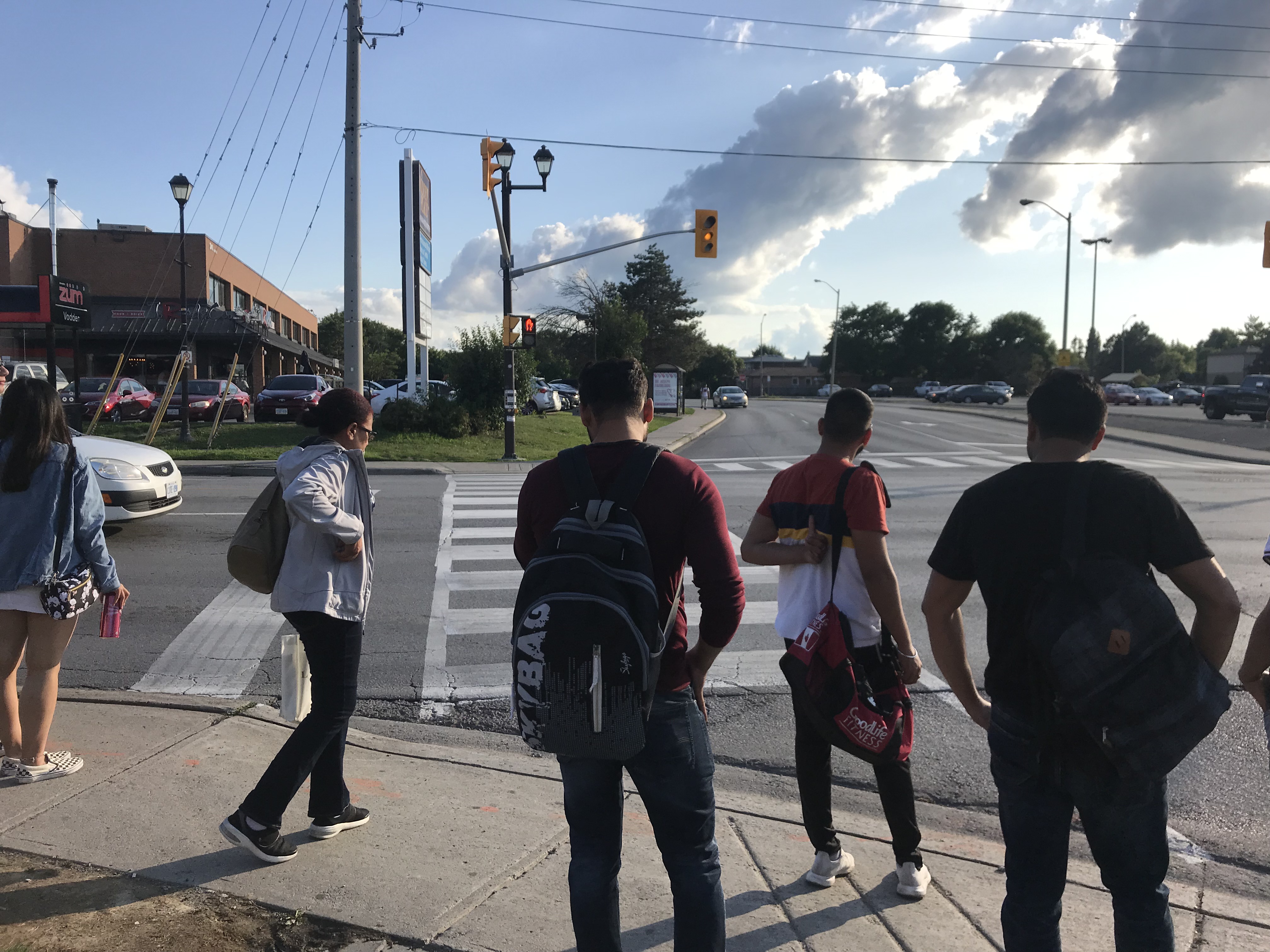
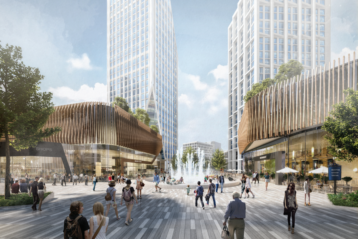
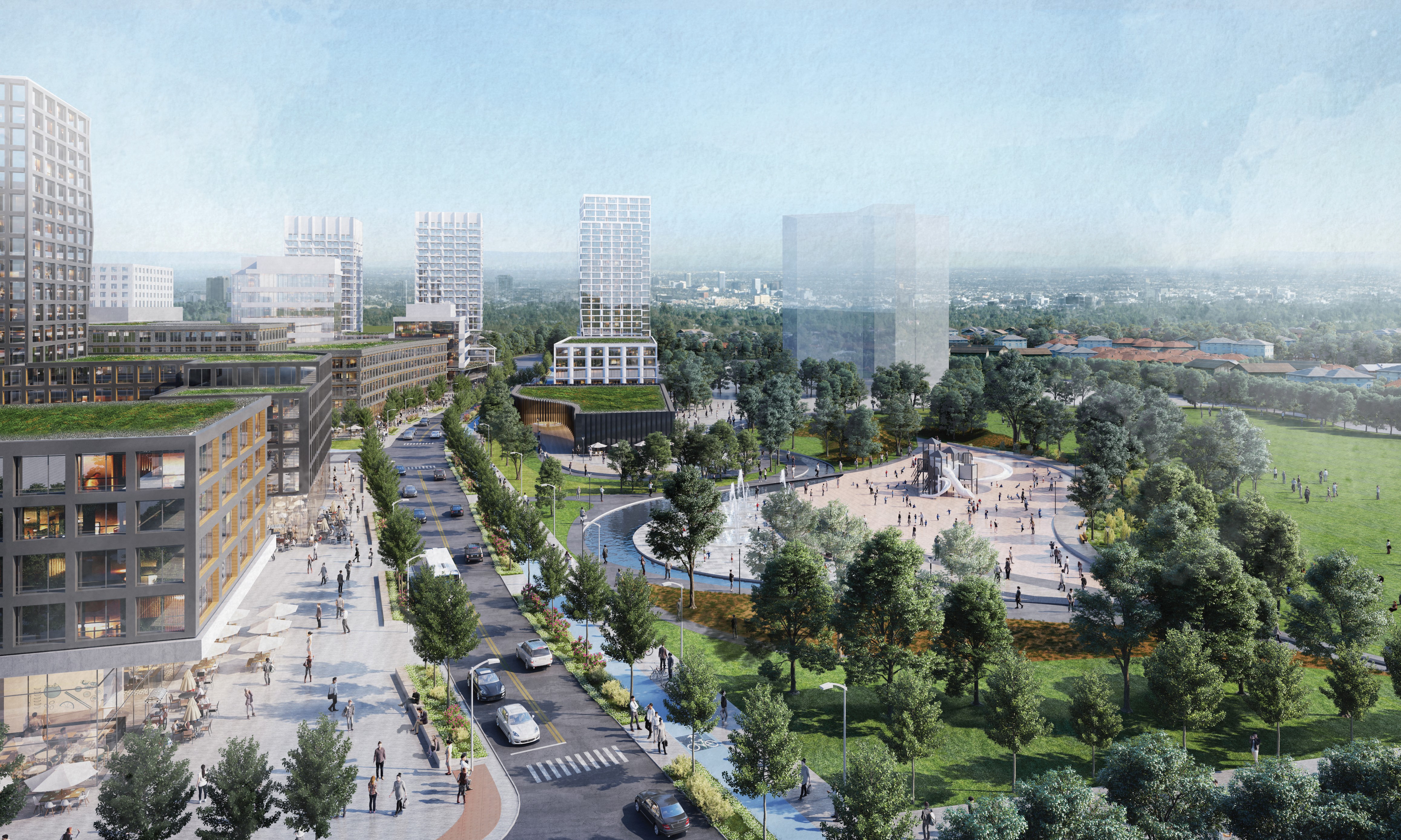
Looking south on Mill Street towards the park expansion and Steeles Avenue. The first phase tower is shown in the middle background.


  • The future of Downtown Brampton

    IMG_6142-001
    Metrolinx-owned houses on Railroad Street, Brampton

    Over the last three years, I have been following developments in Downtown Brampton, especially lands surrounding the Brampton GO Station. In April 2016, Metrolinx, the provincial agency responsible for GO Transit, began buying properties in the northwest corner of Brampton’s downtown core, including twelve houses and two low-rise office buildings. The land assembly was for a new surface parking lot, an odd choice for a transit agency that was otherwise interested in promoting compatible land use and transit connections in designated urban centres.

    It was later revealed that Metrolinx, Ryerson University, and the City of Brampton were working on a new downtown satellite campus, with the main academic building to be constructed on part of the GO parking lot, north of the rail corridor. While the construction of more surface parking in a downtown core was still a bad idea, at least there was a reason behind the land assembly. The new Ryerson site would make use of other city resources, such as the Rose Theatre and the planned Centre for Innovation (CFI). The CFI would include academic space and a central library, to be built on city-owned land south of the GO station and bus terminal.

    university map
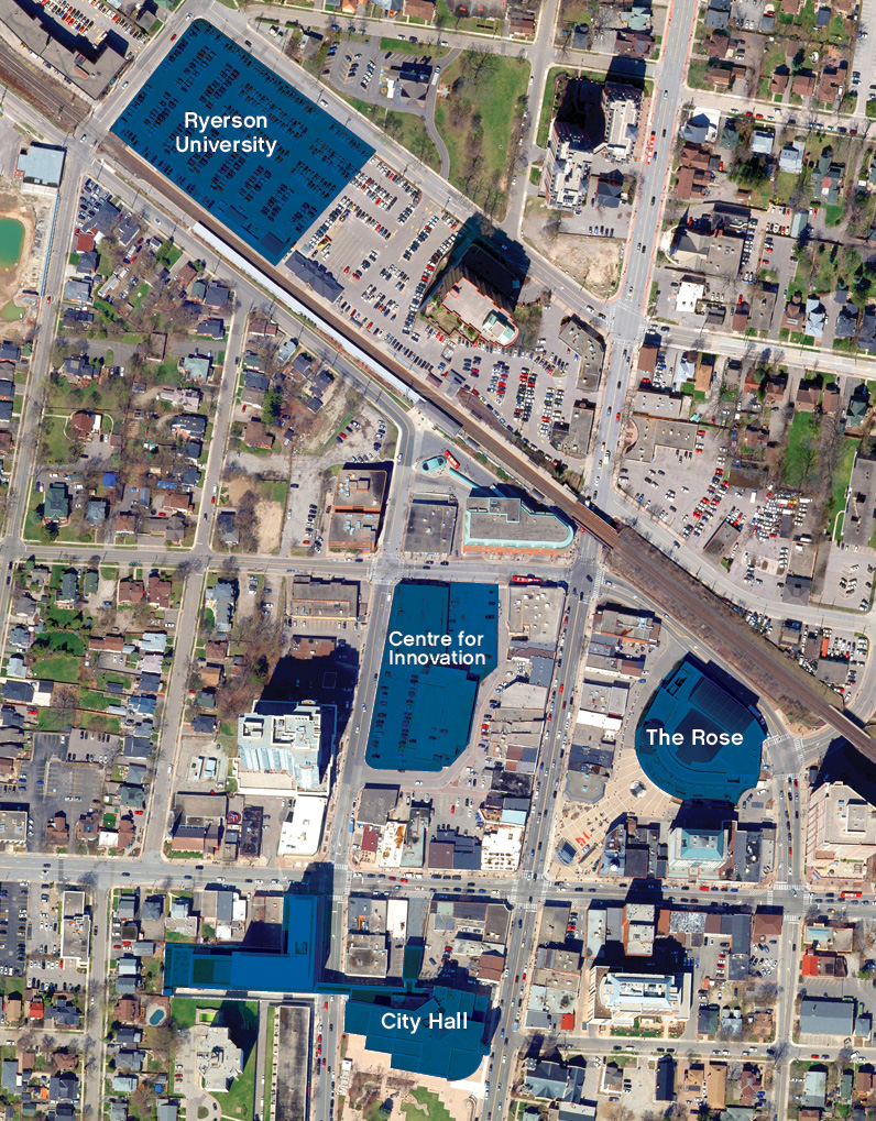
Previous plans for Downtown Brampton, including the Centre for Innovation and the Ryerson campus on the GO Transit lot. Replacement parking would be built on land assembled south of the rail corridor. 

    In October, the newly elected Conservative government cancelled provincial funding for Brampton’s Ryerson campus, as well as other suburban satellite universities planned in Markham and Milton. While Brampton and Ryerson decided to continue working on a scaled-back development including a new centre for cybersecurity, a new plan was developed for downtown revitalization. Details are available in the May 15, 2019 Committee of Council agenda.

    Here’s a simplified summary of the new plan:

    • The CFI will now be built on the north side of Nelson Street West, between Main Street and George Street, on the site of the existing downtown bus terminal, a 6-story office building constructed in 1989, and an older two-storey commercial block. The office building, though only thirty years old, is reported to be in poor condition. The new 15,700 square metre (170,000 square feet) CFI will include the central library, education space, event space, and retail. It may also include additional floors for offices.
    • The bus terminal will be expanded, as the existing facility is too small to accommodate GO and Brampton Transit buses. There will also be room for a new third track through Downtown Brampton, essential for frequent two-way GO service between Toronto, Brampton, and Kitchener.
    • The City of Brampton will likely build a temporary terminal on the south side of Nelson Street to accommodate the demolition of the existing structures and the construction of the CFI and terminal. This land, also owned by the city, is currently occupied by a surface lot and an old commercial building that was originally a Loblaws store. Retail tenants are being evicted from all of the above properties.
    • The city is also interested in using the two office buildings purchased by Metrolinx for short-term academic and administrative purposes as the new CFI is being built.
    • The houses on Nelson, Elizabeth and Railroad Streets acquired by Metrolinx will still be torn down, but without the imminent construction of the Ryerson building, a new parking lot is no longer planned. It is possible that the block will see transit-oriented development in the long term.

    IMG_6155-001
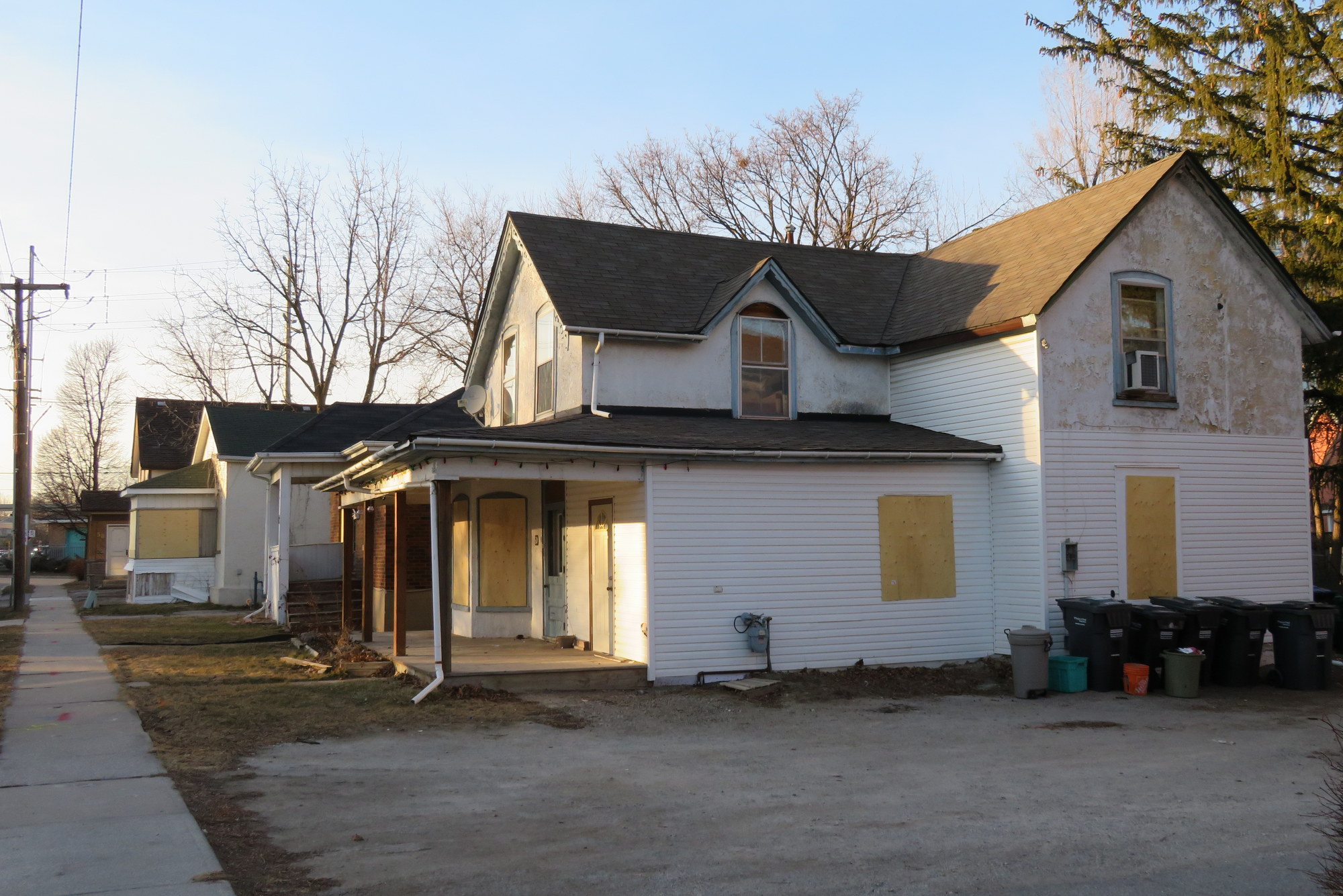
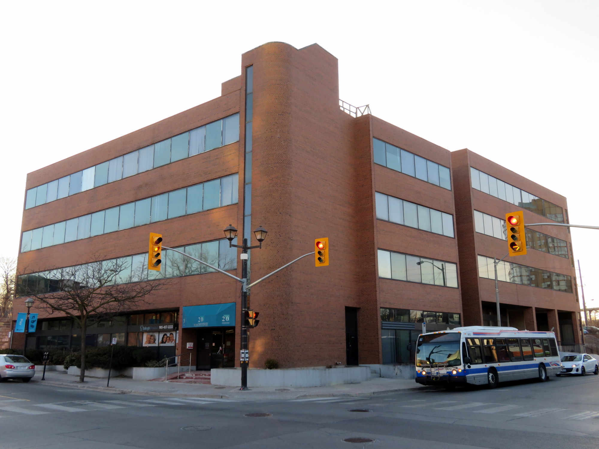
Vacated office buildings at George and Nelson Streets that may see new life under the city’s new plans

    The map below illustrates the revised downtown plans.

    It remains a shame that Metrolinx decided to buy up a whole city block and displace dozens of residents (among the properties it acquired were two heritage houses and a rooming house), especially now that the Brampton Ryerson campus is being scaled back. But the city desperately needs a central library, and happily, Ryerson remains interested in partnering with Brampton. It’s good to see that transit expansion, including a larger bus terminal and GO rail expansion, are part of the plans.

  • Why Brampton’s property taxes are high — and what it can do about it

    5533567557_8523808269_o.jpg
    To effectively reduce its residential property tax rate, Brampton must diversify its tax base

    It’s budget time for most municipalities in Ontario. Unlike cities elsewhere in the world — where municipalities can levy income, sales, and payroll taxes — places like Toronto, Ottawa, and Brampton rely on property taxes for most of their operating revenue, and they are complicated.

    Toronto homeowners enjoy the cheapest property tax rates in the Greater Toronto Area, too low in fact to properly support city services like transit, housing, or adequate snow clearance.

    Meanwhile, Brampton has some of the highest property tax rates in the city. A typical house in Brampton whose assessed value is $800,000 would be levied $8,284.73 in property taxes in Brampton. A similar house in suburban Scarborough or Etobicoke might be worth more, but the taxes on a house accessed at $1 million would be just $6,355.10.

    While freezing property taxes might be popular, it isn’t a sustainable solution to high property taxes. A property tax freeze means that the city will not collect any additional tax revenue, regardless of new development or higher property assessments; unlike income and sales taxes, property tax revenue does not grow with the economy. Commercial and industrial property tax rates are higher, but Brampton doesn’t have enough of either land use compared to housing.

    Brampton’s property tax issues are structural; tax cuts or freezes will not help. Having a diverse tax base, like Toronto’s, is a better solution, but it won’t be easy. I explain more in Bramptonist. 

  • What GO Transit service to Brampton might look like without the freight bypass

    IMG_0610-001
    VIA and GO trains meet at Brampton Station

    In 1967, GO Transit launched a new rail service between Pickering and Hamilton. The new commuter train service was made possible as GO just built a new freight bypass so its trains could avoid Downtown Toronto and connect to a new sorting yard in Vaughan. Today, trains on the Lakeshore Line operate as frequently as every fifteen minutes during weekdays, and every half hour on weekends. Unfortunately for Brampton, that freight bypass built in the 1960s runs right through its downtown core, limiting the number of passenger trains that can serve Brampton, Guelph, and Kitchener.

    Last December, the provincial government cancelled plans for a new freight bypass that would have diverted CN trains from a critical section of track in Brampton, allowing for frequent GO and intercity services. Around the same time, a new GO Transit schedule resulted in extreme overcrowding and extended delays on the Kitchener Line. As population and ridership grows, there are few answers and little promise of relief that the freight bypass would have provided.

    In my debut article for Bramptonist, I comment on the future of the Kitchener Line, the only GO line serving Ontario’s fourth largest city and an important commuter link to Guelph and Kitchener-Waterloo. What can Brampton expect now that the freight bypass is dead?

  • What’s next for Downtown Brampton?

    IMG_6148-001
    Boarded up houses on Elizabeth Street, Downtown Brampton

    Earlier this year, the provincial government announced the location of Ryerson University’s Brampton campus, a partnership with Sheridan College, to be built on the GO Station parking lot in Downtown Brampton. Meanwhile, Metrolinx quietly purchased several houses and office buildings south of the station for new GO Transit surface parking, replacing the spots that Ryerson will build upon.

    The merits of a satellite university campus are open to debate – some smaller satellite campuses have struggled to attract students and faculty and distinguish themselves. Brampton’s the planned campus site was, by far, the best one for both the City of Brampton and Ryerson University.

    But today, the Progressive Conservative provincial government, elected in June, cancelled three planned suburban post-secondary education campuses — the York University/Seneca College campus in Markham, the Wilfrid Laurier University/Conestoga College campus in Milton, and the Ryerson University/Sheridan College campus in Brampton.

    This announcement came only one day after the October 22 municipal elections. While Toronto elected a smaller 25-ward council and returned John Tory to the mayor’s office, the voters Brampton elected former Ontario PC leader Patrick Brown as mayor, narrowly defeating incumbent Linda Jeffrey. Brown had just moved to Brampton after his campaign for the elected Peel Region Chair was cancelled at the same time Brown’s successor as PC leader, Premier Doug Ford, imposed the new 25 ward structure on Toronto. We can only speculate if the animosity between Brown and Ford was a factor in this announcement. It’s more likely that the decision to cancel the three campuses was already made, with the announcement timed to take place after the municipal elections. In any case, mayor-elect Brown’s job has already become more interesting.

    Brampton’s satellite campus, which had a 2022 opening date, would have hosted 2,000 undergraduate students. Though this is tiny compared to Ryerson’ downtown campus, which 36,000 undergraduate students currently enrolled, it was the best possible site, adjacent to the GO station, several Brampton Transit routes, the Rose Theatre, and local shops and restaurants and recreation facilities. The school would have made use of the the planned Centre for Innovation, a proposed new central library to the corner of George and Nelson Streets.

    university map
    Map of the Ryerson University campus site, the Centre for Innovation, and other downtown buildings. From the City of Brampton website.

    The York University/Seneca College campus in Markham was also strategically located, on a site adjacent to Unionville GO Station, in the mixed-use Downtown Markham development. In contrast, the Milton site was in a greenfield far from transit links. It’s fair to say that I’m not too disappointed on Milton’s behalf.

    With Brampton’s campus dead, for now, there’s still the land on the south side of the station. Three homes are already knocked down, while two office buildings and several houses are boarded up, awaiting demolition.

    Will Downtown Brampton see nothing more than additional GO Transit surface parking now that the campus is cancelled? Or will a new opportunity come along?

    BramptonParkingLot
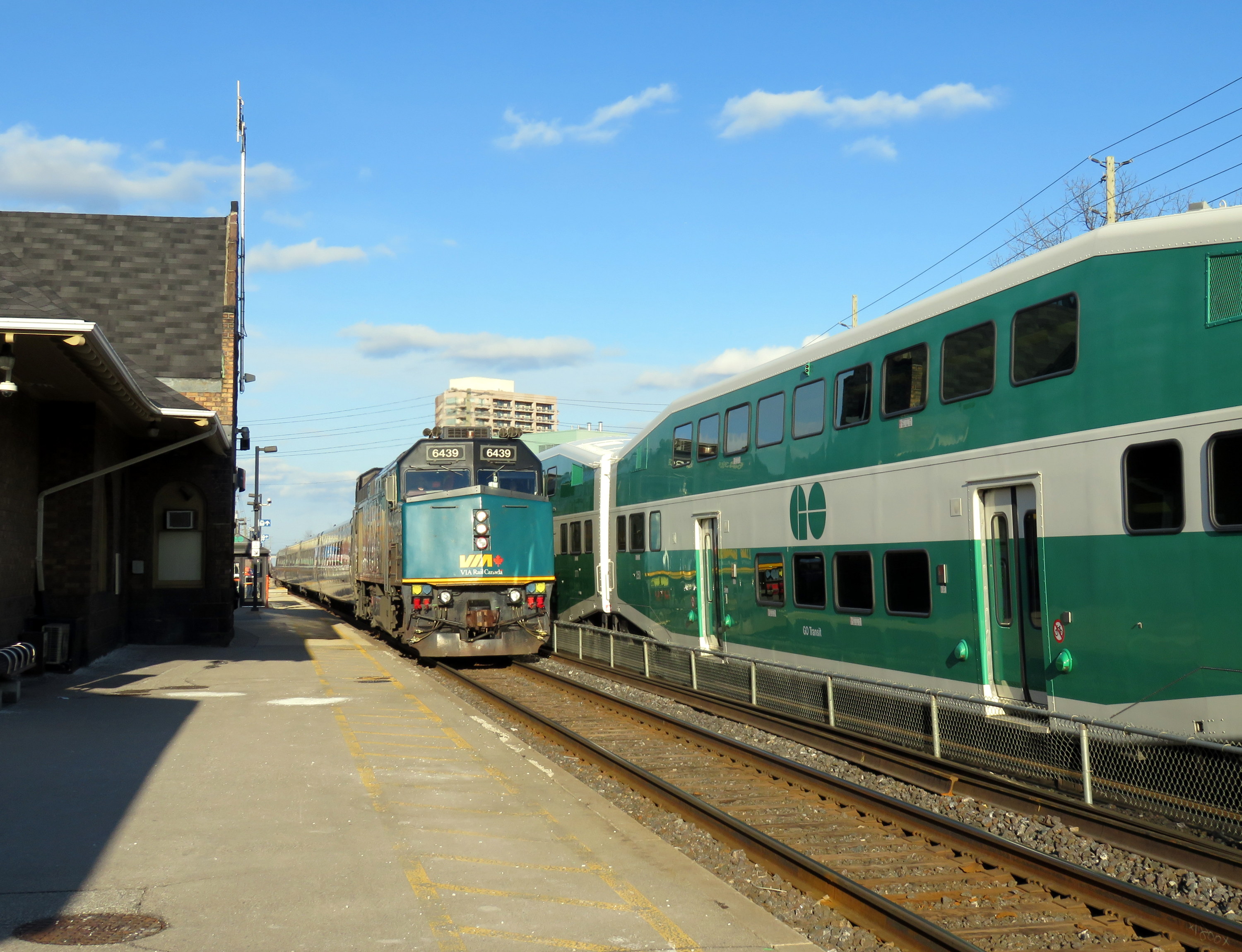
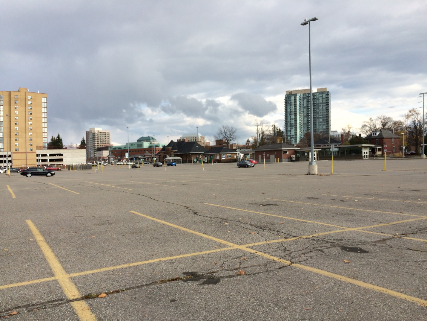
The existing GO Transit lot at Brampton Station, where the Ryerson University/Sheridan College campus was planned