Category: Walking

  • Where the sidewalk ends in Toronto (Updated)


    IMG_3357
    McNicoll Avenue at Boxdene Avenue. There’s no sidewalk on the south side of this busy Scarborough road.

    Update: I posted a revised and updated version of the map and article on Spacing Toronto. There, I mention a new absurdity in the war on sidewalks: on Glen Scarlett Road, near the old Stockyards in Toronto’s Junction neighbourhood, the city is proposing  a new sidewalk for 2016 as part of a road reconstruction project.

    The local councillor, Frances Nunziata, is siding with local industry in opposing a sidewalk. Local industries — including slaughterhouses and warehouses — oppose a sidewalk as it would cross their loading docks; Nunziata’s office claims that since the street “is unsafe for pedestrians to be walking on due to heavy traffic, [the City] should not be encouraging pedestrians to use this road by installing a sidewalk.”

    This logic is completely counter-intuitive. It ignores the needs of workers walking to work, and local residents walking to the streetcar loop at St. Clair Avenue and Gunns Road, or to nearby shopping and residential areas.


    There was a very interesting interview on CBC Radio’s Metro Morning on Tuesday, February 16). Host Matt Galloway spoke with Fiona Chapman, the City of Toronto’s manager of pedestrian projects, on missing sidewalks. Nearly one-quarter of all local streets in Toronto don’t have a sidewalk; many more only have a sidewalk on one side of the street. Chapman was discussing a presentation to the City’s Disability, Access, Inclusion and Advisory Committee on staff recommendations that would seek to fix this problem.

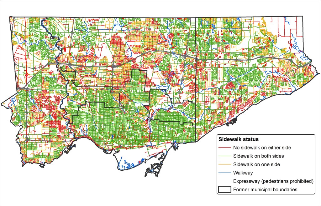
    CityData - SidewalksStatic map showing the City of Toronto’s sidewalk inventory as of 2011.

    Most local streets that don’t have sidewalks are found outside the old Cities of Toronto, East York and York, particularly in parts of Etobicoke, North York and Scarborough built in the 1950s and 1960s. Some of these residential and industrial streets were built with ditches instead of storm drains; others were laid out without sidewalks in mind. In the master-planned Don Mills development, there are many walkways connecting parks, major roads, and schools; it was likely intended that these would be used for getting around on foot rather than sidewalks. In other post-war subdivisions, particularly affluent areas like those in central Etobicoke, it was probably assumed that everyone would get around by car.

    The City of Toronto is hoping to change this. As roads come up for reconstruction, the new policy, recommended by staff, is to install a sidewalk where there isn’t one already, even despite local opposition. The current policy, in place since 2002, is that a new sidewalk could only be installed on an existing local street after the local councillor completed a consult of the neighbourhood and there was a consensus supporting the installation.

    In Toronto, the installation of new sidewalks has been surprisingly controversial. But the city’s presentation lists some of the reasons why sidewalks are often opposed. Sidewalks have to be cleared by the adjoining landowner. Residents can’t park their cars in the driveway if they block the sidewalk. They might result in the removal of landscaping or trees. And there is a minority who just want to keep outsiders out of their neighbourhoods. You could call this NIMBY-ism, even though sidewalks are technically is in the front yards, not the backyards, of local opponents.

    Sidewalks provide safe, accessible routes for pedestrians, especially important for people using strollers or mobility devices. They promote the city’s initiatives encouraging children to walk to school, for all persons to engage in physical activity, and for seniors to age at home. City policy, including the Toronto Pedestrian Charter, supports sidewalks.

    On Chine Drive, in an affluent part of Scarborough near the Bluffs, local residents opposed the construction of a sidewalk, even though it would provide a safe path to a nearby school. Since 2004, some residents opposed the sidewalk, claiming that they were afraid it would “take away from the rustic look of the neighbourhood.” Supporters, including parents with young children, wanted a safe route to the local school. It took ten years, but in 2014, the sidewalk was installed.

    Last year, on nearby Midland Avenue South, there was a similar fight to keep sidewalks off of that street. This is despite the fact this section of Midland Avenue is designated as a collector road, and is part of the Waterfront Trail’s route in the Scarborough Bluffs area. The city owns the land, known as a boulevard, where the sidewalks would go, but without the consent of local homeowners, the city was left in a bind. This new city policy will hopefully solve this problem.

    Below, I created an interactive map of the City of Toronto’s sidewalk inventory, created with data from the City of Toronto’s Open Data Initiative. It shows each public street in the city of Toronto (excluding private roads and laneways), as of 2011. I made a few edits, such as including the new Chine Drive sidewalk, and correcting a few errors that I was aware of.

    Almost every arterial and collector road in Toronto has a sidewalk on at least one side of the street. Exceptions include Highway 27 and Black Creek Drive, where, like expressways, pedestrians and cyclists are prohibited, the Bayview Drive Extension though the Don Valley, and in the far northeastern part of Scarborough, in Rouge Park. But it’s the local streets, marked in orange and red that are most apparent.

    https://seanmarshall1.cartodb.com/viz/3f206014-d4f2-11e5-b47b-0e787de82d45/public_map


    Providing safe, accessible, and consistent pedestrian infrastructure is simply the right thing to do. The city owns the land on which sidewalks can be put down, if they aren’t already. There are legitimate concerns that need to be taken into account when new sidewalks are proposed — trees and landscaping especially — but at the end of the day, the needs of vulnerable road users need to be addressed first and foremost.

  • The challenge of getting to the bus stop

    IMG_8796-001

    It’s time for a rant on suburban transit, and how unnecessarily difficult it can be to get to the nearest bus stop.

    Transit has a harder time in the suburbs. Population densities are lower than in neighbourhoods developed before the Second World War. Suburbs are not only built for the car, but they’re laid out with crescents, cul-de-sacs and winding street systems meant to discourage through traffic in residential areas. Backyard fences line arterial roads, safe pedestrian crossings might be a ten or fifteen minute walk down the road. These factors can make it difficult for people living in subdivisions and near busy streets to easily access a nearby bus stop.

    Last year, Streetsblog USA asked its readers to vote for the sorriest bus stop in America, and some of the submissions are truly awful. But in the Greater Toronto Area, there are many examples of poorly designed or located bus stops. Intersections like the one at Steeles Avenue West and McMurchy/Malta Avenue in Brampton, which, granted isn’t as bad as the StreetsblogUSA submissions, is just one example of how not to get people out of cars and onto public transit. Some thought into placing bus stops and improving access to local transit is necessary.

    I like Brampton Transit and what they’ve been doing over the last decade in my hometown. In 2005, the suburban transit agency began to re-organize its routes into a grid system. There were some hiccups: additional transfers, combined with low frequencies made some trips more difficult, but as ridership improved, so did service levels on key corridors. Schedules were adjusted to improve transfers. Connections to Toronto and Mississauga were improved. My hometown’s bus system was no longer a joke.
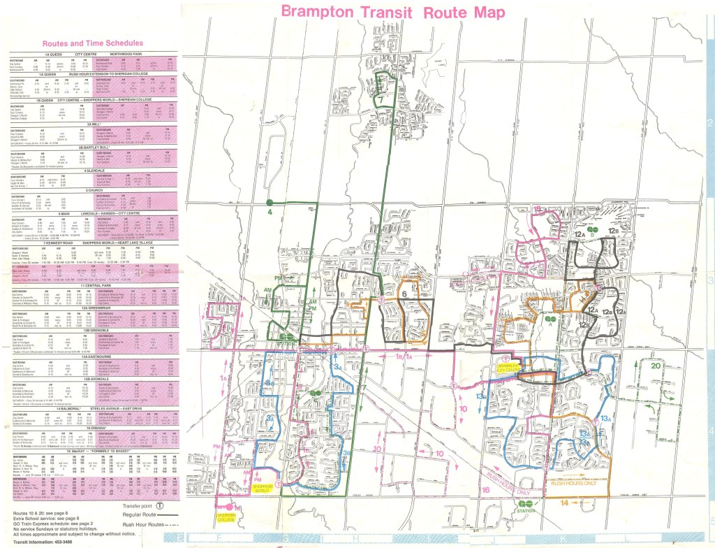
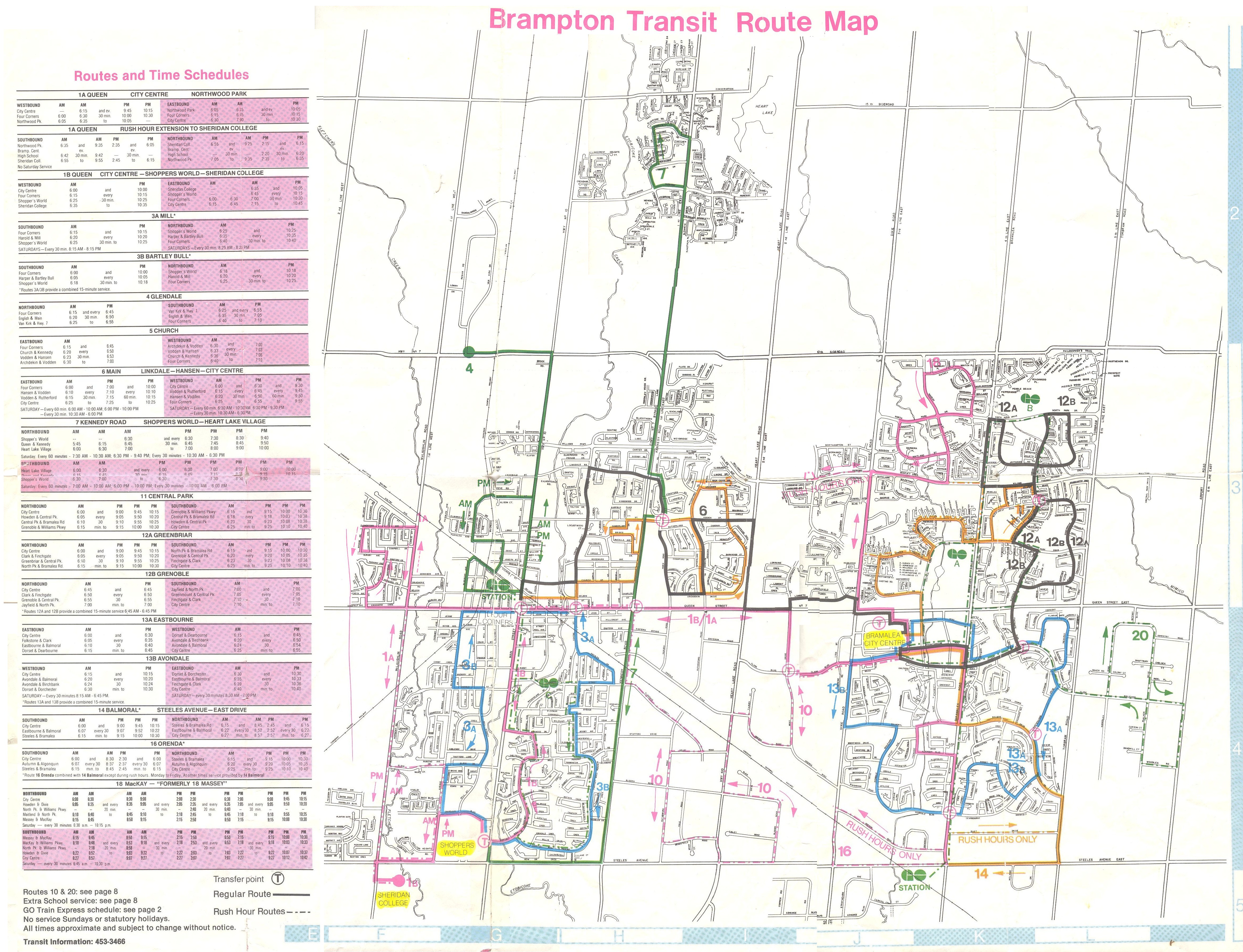
    Brampton Transit - December 1980 front

    Here’s what Brampton Transit looked like in 1980, marked with meandering routes and one-way loops. The 2015-2016 system map is here [PDF]. 

    In September 2010, Brampton Transit introduced its first “Züm” route, 501 Queen, which connects Downtown Brampton with York University. Like the first phase of York Reigon’s Viva and Durham Region’s Pulse, Züm was developed as a specially-branded limited-stop bus service. Züm stops have special shelters, with real-time schedule information, winter heating. And on sections of Queen Street and Steeles Avenue, special “queue jump” lanes allow buses to by-pass cars and trucks waiting at intersections.

    Services such as Zum and Viva, which operate mostly in mixed traffic should not be mistaken for “bus rapid transit” such as Ottawa’s Transitway or Bogota’s TransMillenio; “BRT-lite” or “quality bus” are more appropriate terms for these routes. Route 501 Queen operates every 15 minutes or better, seven days a week, into the late evenings. It’s proof that quality transit can be operated in Toronto’s suburbs, and be a success.

    Since Route 501 was introduced, three more Züm routes were added: 502 Main, which follows Main and Hurontario Streets as far as the Mississauga City Centre Terminal at Square One, 511 Steeles, and 505 Bovaird. Each of these routes complements an existing local bus route, though the level of service on these other routes are not as high as on Queen Street; Züm service ends sooner in the evenings (though local bus service operates until after midnight) and frequencies are lower.

    With the introduction of Züm, and combined with other service increases, Brampton Transit ridership increased by nearly 30 percent in the last five years (2011-2015). This increase is significantly higher than the rate of Brampton’s population growth over the same time period.

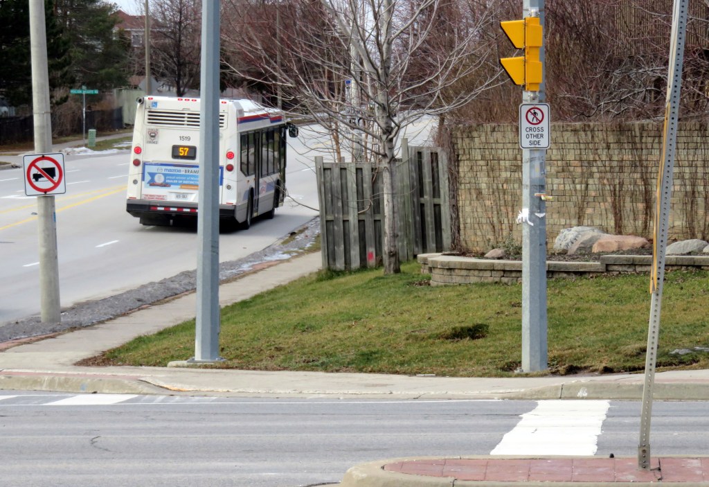
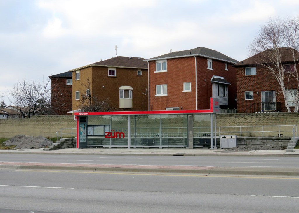
    In September 2015, the 511 Steeles Züm bus was extended west from Shoppers World to Lisgar GO Station in Mississauga; standard Zum shelters were installed along the corridor, including the intersection of McMurchy/Malta Avenues and Steeles. This intersection is only a few hundred metres from where I grew up. The existing bus stops for local bus routes were relocated to the new shelters, like the one seen below.
    IMG_8800-001

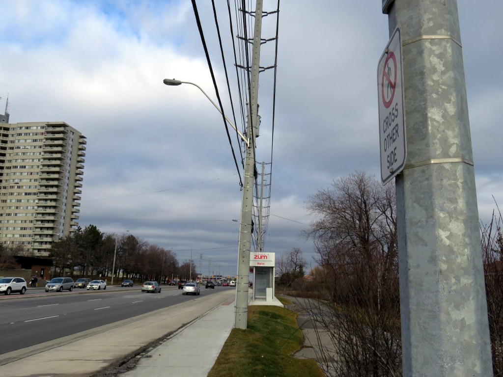
    Both bus stops were installed on the east side of the intersection. The trouble is that pedestrian crossings are prohibited on the east side, due to the priority given to motorists at this suburban intersection. Therefore, transit users may have to cross the intersection three times to get to and from their bus; with several rental apartment towers, townhouses, and compact single-family housing, this is not a low-density neighbourhood.
    IMG_8797-001

    From a traffic engineering rationale, this traffic arrangement, which has existed for about a decade, makes sense. The majority of traffic is on busy, six-lane Steeles Avenue. From the north, most traffic on McMurchy Avenue turns east (left) onto Steeles, while Malta Avenue is a short stub, serving a small townhouse development on the south side of Steeles Avenue. Eventually, Malta Avenue will continue south, hooking up with another section of the same street. For now, a dormant farm field separates the two streets and awaits development.

    To facilitate through traffic on Steeles, the cross streets, McMurchy and Malta, are given only green time equivalent to the minimum pedestrian crossing time. And to facilitate the left turns from McMurchy to Steeles, pedestrians are banned from crossing that side of the street. From the viewpoint of a traffic engineer, this makes sense, but it’s a mindset that ignores the needs of pedestrians and transit customers, and with the re-location of the bus stops, this has become more of a problem. This intersection is owned and maintained by the Region of Peel, not the City of Brampton, as Steeles is a regional road.

    There are two options here, and at other places where people must give way to cars:

    1. Allow pedestrians to cross at all four sides of the intersection, ignoring, for a minute, the desire for cars and trucks to move through with minimal disruption; or
    2. Move the bus stops to the west side of the intersection, minimizing the inconvenience for transit riders.

    Brampton Transit has done a fine job growing its ridership over the last decade, making it a bit easier to get around Toronto’s second-largest suburb without a car. But situations like these, where pedestrian access can be improved, are low-hanging fruit that would demonstrate that transit users are valued, even in the car-dependent suburbs. The current arrangement is unacceptable. Brampton and Peel Region should do better.

    There are plenty of cases elsewhere where there are poorly-located transit stops. One example here in Toronto is the eastbound stop for the TTC’s 42A Cummer bus at McNicoll Avenue at Boxdene Avenue in north Scarborough. There’s no sidewalk on the south side of McNicoll, and Boxdene runs north. Anyone attempting to use this stop is at the mercy of traffic on this busy, four lane road.

    Overall, I would like to see more thought put into locating bus stops in general and making sure they’re easily accessible.

  • A vision for King Street

    21207239313_0c5746b3f8_o

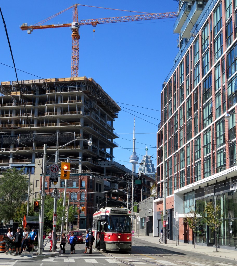
    In today’s Toronto Star, city columnist Ed Keenan reports on the “King Street Visioning Study,” a city planning project that will soon be available for public feedback. The study proposes improving streetcar operations along the King Street Corridor between Dufferin and Parliament Streets as well improving the public realm, making it a more pleasant place to walk. The 504 King Streetcar is the busiest surface route in the TTC’s system, and as I, and many others, have said before, the streetcar needs to be able to move more people more efficiently. But now City Planning is leading the study, not the TTC, making this a more holistic vision for King Street.

    Chief City Planner Jennifer Keesmaat says that it’s “reasonable” that the initial pilot projects could be started in early 2017. Work has already been contracted to some of the same firms that were responsible for transforming Queen’s Quay (which despite some construction delays, and conflicts in a few places between pedestrians, cyclists, and motorists, is a fantastic project).

    Keesmaat echoes previous attempts at creating a King Street Transit Mall, suggesting a similar system of alternating one-way sections that would provide for taxis, deliveries and passenger drop-offs and pick-ups, but forcing through traffic onto parallel streets. Extending transit priority all the way from Dufferin to Parliament could do a lot to streetcar improve operations, especially as the TTC is planning a new 514 route on King between Dufferin and Cherry Streets to supplement the overburdened 504 line and better serve the West Donlands, Distillery District, and Liberty Village.

    Yes, King Street improvements would start off as pilot projects, much like the bicycle lanes on nearby Richmond and Adelaide Streets, or the decade-old 2-hour transfer on St. Clair Avenue, or the Toronto Hydro ALAMP street lighting trials that should have concluded years ago. (Toronto seems to like permanent pilot projects.) That said, previous plans for a King Street transit mall never even got to the “pilot project” phase.

    But hearing that pedestrians and transit will be getting priority is music to my ears. Knowing that City Planning, and not just the TTC, is looking at this gives me optimism that this could finally go ahead. There will be opposition from businesses along the corridor, taxi drivers, suburban politicians concerned about a non-existent “war on the car.” And it’s not clear if Mayor John Tory is in favour, or a majority of city councillors.

    An improved public realm is especially appropriate on King Street, especially through historic Old York on the east and the cultural and tourist draws of the Entertainment District on the west. Sidewalks are often crowded, especially as the theatres get out in the evening, but with such diverse uses along the corridor, from bank towers to night clubs, King is one of Toronto’s most vibrant streets. Toronto often has trouble with attractive streetscaping (thanks to ugly wooden poles and overhead wires, cheap, grey street furniture, and ugly traffic signals), but it has recently managed to get Queen’s Quay (mostly) right.

    As for design, I’m hoping for something interesting and something different. I’d do away with the Muskoka chairs mentioned in Keenan’s article. They’re wonderful on Toronto’s waterfront, but I’d like to see some imagination on King Street. What about seating shaped like director’s chairs in front of the TIFF Lightbox? (Oh, and on the subject of TIFF, could we tell film festival organizers to stuff it when they want to wreck the King Streetcar again in 2016?)

    After years of talk about fixing King Street, there’s a very serious proposal to do something about it. Maybe the third time’s the charm.

  • Not seeing the light on pedestrian safety

    IMG_9773

    Earlier this week, I ranted on Twitter about a poster I spotted on the TTC. The poster, showing a pedestrian crossing a downtown street, is one of a series of posters aimed at pedestrians, all with the tag “Stay Focused. Stay Safe.” They are co-produced by the TTC and the City of Toronto.

    The poster, as seen above, shows a blurry image of a pedestrian crossing the street, wearing a backpack and a dark jacket. But it shows that pedestrian crossing legally and safely at one of the safest intersections in Toronto – Yonge and Dundas. We see cars and a streetcar waiting at the light in the background. There’s nothing wrong with this picture. What part of “stay focused” does clothing come in, anyway?

    (Some of the responses to my rant were hilarious, like the woman who compared walking downtown wearing dark clothing with hiking in rural B.C. and not being prepared for cougar attacks.)

    With the new school year and with the shorter days, it isn’t a bad time to be reminding all road users about how to stay safe. Other posters remind TTC passengers to cross at designated crosswalks and to pay attention when crossing the street, rather than focusing on their smartphones. While crossing many streets midblock isn’t itself dangerous – as long as one crosses a quiet street with caution it’s usually quite safe – the advice given in the poster above bothers me. It indirectly blames pedestrians for the clothes they wear.

    Most fall and winter clothes, especially jackets, are dark – black, navy blue, dark grey, etc. Instead of blaming pedestrians, should we be blaming clothing retailers? Should we be requiring all pedestrians to wear high-visibility clothing, and be equipped with bright flashing lights? Or as David Hains pointed out in Torontoist, why aren’t cars required to be brightly coloured as to be seen better by pedestrians?

    In Spacing, fellow Walk Toronto co-founder Dylan Reid wrote about, and debunked some common myths about pedestrian collisions. The vast majority of pedestrians in Toronto – 67% – hit by motorists had the right-of-way, such as with a walk signal at a traffic light or in a marked crosswalk. Only in 19% of collisions did injured pedestrians not have the right of way. And downtown, where there is a higher volume of pedestrians, there’s a safety in numbers; it’s on busy suburban arterials where pedestrians are most at risk; speed kills.

    And as for bright-coloured clothing, it’s a great idea for joggers and runners at night, especially in rural areas. But it doesn’t necessarily prevent collisions. I was hit on Dupont Street by a careless taxi driver two years ago, even though I was riding safely in a bike lane. My bright, reflective jacket, my steady front and rear bike lights and my flashing helmet-mounted lights did not do a thing. I’ve been nearly hit over a dozen times by aggressive drivers racing through red lights or making right turns without looking for pedestrians with the right of way; I was attentive, and avoided injury in every case.

    Some factors that make pedestrians difficult to see at night include poor lighting, inattentive and/or aggressive drivers, and motorists who don’t put their headlights on at night. There’s nothing wrong with reminding all users about how to get around safely; pedestrians should always be attentive when walking in and around traffic. There’s lots that can be done to promote pedestrian safety: better infrastructure, improved lighting, lower speed limits, and so forth. Safety campaigns are a useful tool. But blaming pedestrians for their wardrobe is ridiculous and misses the point.