Category: Development

  • Visiting America’s other urban railway park

    Visiting America’s other urban railway park

    An abandoned railway signal towers over Philadelphia’s Rail Park

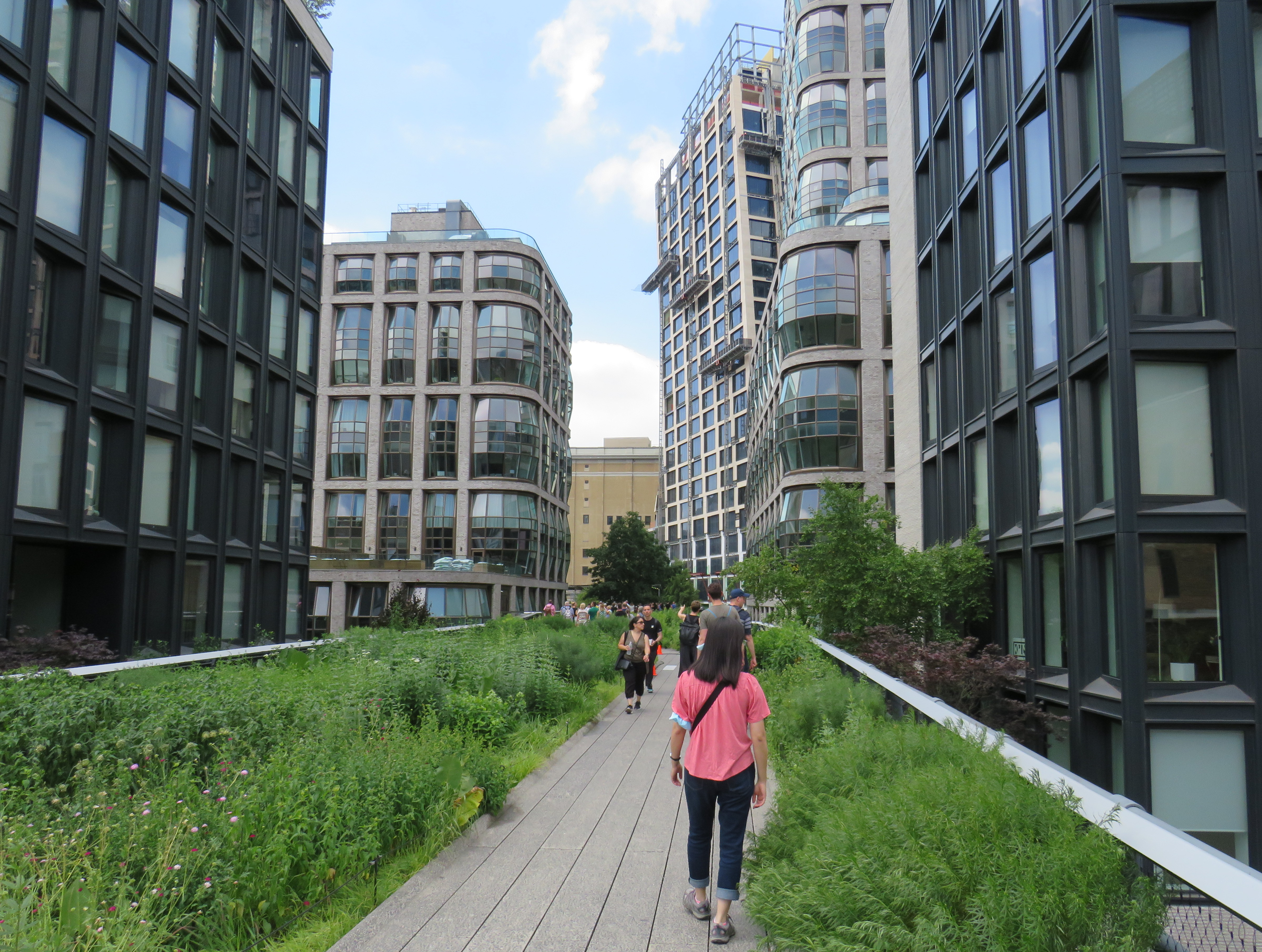
    On a road trip early this summer, my spouse and I paid a visit to New York and Philadelphia. In New York, we walked the famous High Line, which revitalized an abandoned elevated freight railway corridor, transforming it into a popular grade-separated walking path on Manhattan’s Lower East Side.

    New York’s High Line

    While in Philadelphia, I made a point of visiting another abandoned rail viaduct — Rail Park. It’s as ambitious as New York’s famed public space, but — for now — it is much less known.

    The viaducts, cuts, and tunnels that will make up Philadelphia Rail Park trace their origin to the golden age of railroading. The Philadelphia and Reading Railroad, which connected Philadelphia with its northern and western suburbs, industrial towns to the northwest, and the lucrative anthracite coal fields of northeast Pennsylvania. For many years, the Reading Railroad, as it was known, was one of the United States’ most profitable companies. In 1893, the railway opened its Philadelphia Terminal, which became famous for the public market that was established below the station platforms. To this day, the Reading Terminal Market remains a vital city landmark. In the 1930s, most of the commuter services were electrified.

    The 1893 Reading Terminal headhouse, now the entrance to the Pennsylvania Convention Center

    By the 1970s, both the Reading and PRR were bankrupt. PRR merged with its New York-Chicago rival New York Central in 1968, before it too went into insolvency. Conrail took over many failing railways in the US Northeast and Midwest, consolidating operations, abandoning or transferring redundant track, and transferring most remaining commuter train operations (which were not assumed by Amtrak) to regional and state transit authorities.

    In the mid-1980s, the Southeast Pennsylvania Transit Authority (SEPTA), which assumed control of the regional rail services formerly operated by the PRR and the Reading undertook an ambitious project to unite the separate regional rail systems. A new four-track tunnel was constructed east from PRR’s Suburban Station, and a new station — Market East — built to replace the old Reading Terminal. For the first time, trains could run through central Philadelphia, providing improved regional rail services.

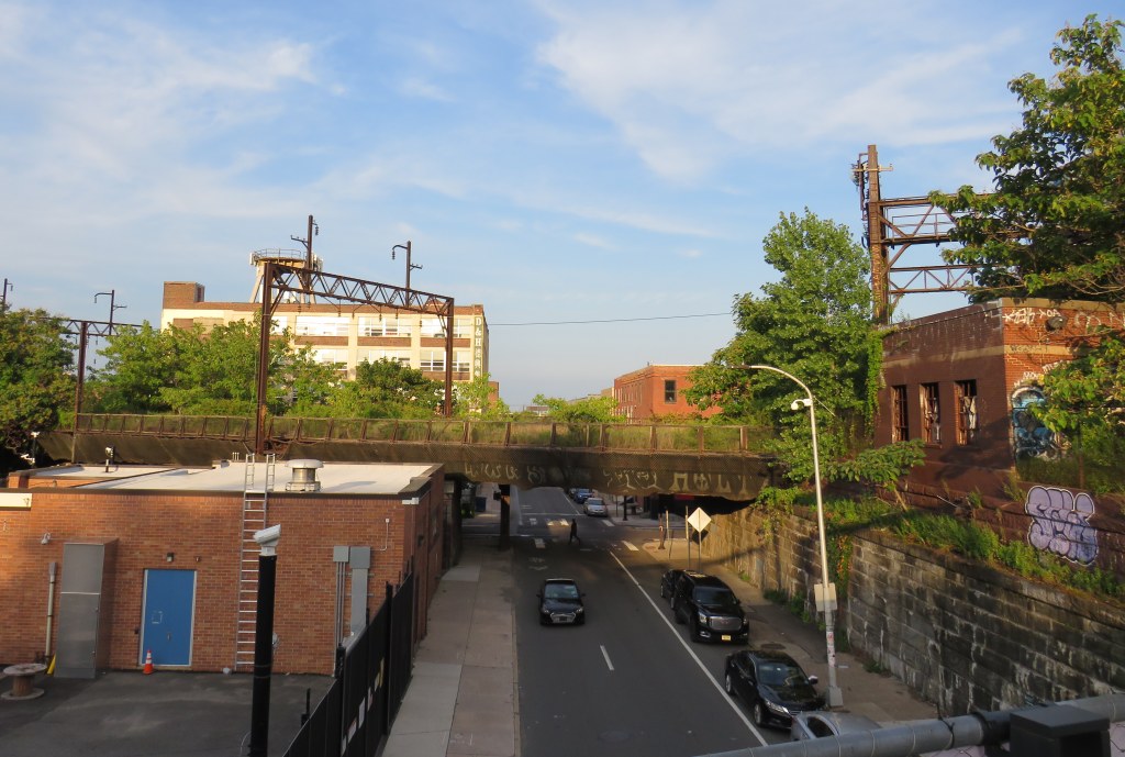
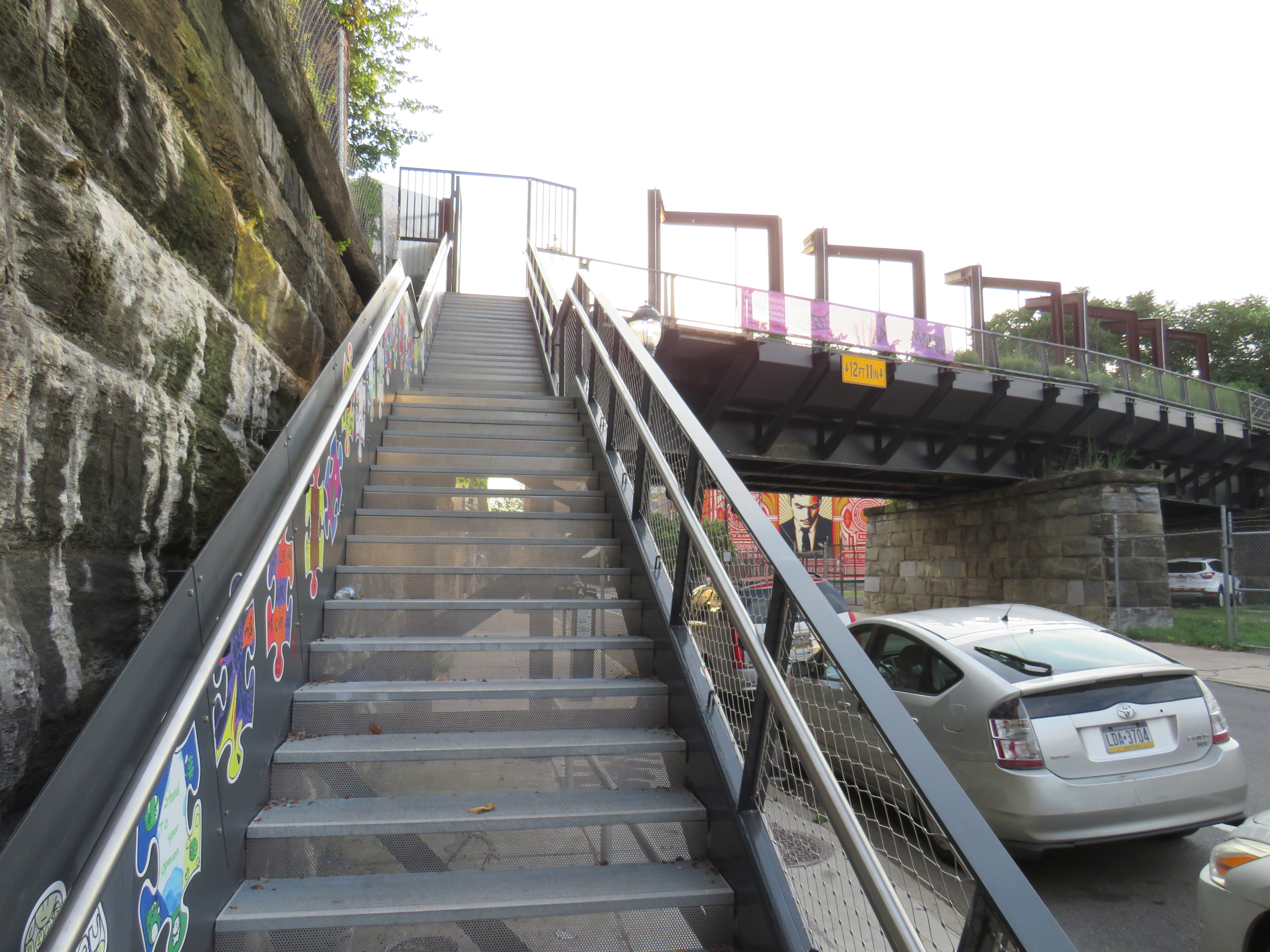
    Though the historic Reading Terminal headhouse and the famous market were preserved, the station platforms were removed to make way for a new convention centre. For years, the abandoned viaducts and tunnels leading into Reading Terminal sat unused. At least they did, until June 2018.

    Entrance to the first phase of Rail Park, at Noble and 13th Streets

    In 2018, a short, initial phase of Rail Park opened to the public. Spanning just two blocks, from Noble and 13th Streets to Callowhill and 11th Streets, it is still a remarkable public space. Like New York’s High Line, the short section of viaduct provides new viewpoints over gritty city streets, with temporary and permanent public art installations along the route.

    A map of the proposed extensions of Rail Park, with the opened first phase marked. Interactive map here.
    Looking north up 13th Street, towards the gentrifying Spring Garden neighbourhood
    “Workshop of the World” – an interpretive plaque provides information on the industries that lined the Reading Company’s route through Philadelphia
    An art map of local industries that existed immediately north of Reading Terminal, made from punched Corten steel
    Looking east to the intersection of Callowhill and 11th Streets. For now, the only fully accessible entrance to Rail Park is at Noble and 13th Streets. The viaduct from the north is visible at left; this will be part of a future phase of Rail Park.
    A stairway leading up from Callowhill Street. The metal frames at the right hold swings for the public to enjoy.

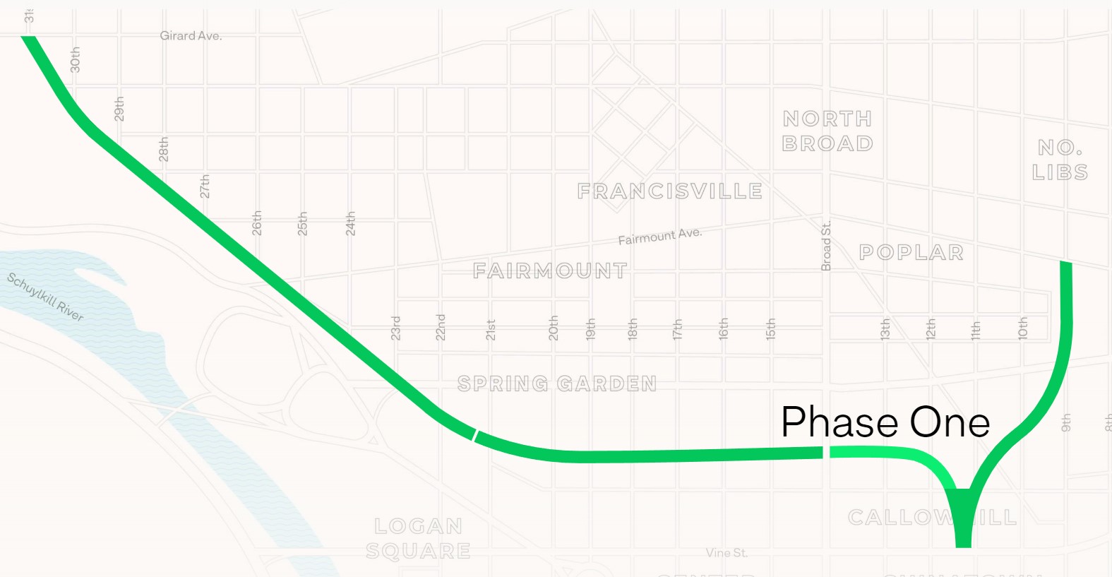
    Future park extensions will continue westward from 13th Street to a below-grade cut starting at Broad Street. It will continue west to the Benjamin Franklin Parkway and the Philadelphia Museum of Art (where the Rocky statue can be found outside), where it will enter a tunnel before emerging at Girard Avenue near Fairmount Park, the greatest of Philadelphia’s urban green spaces. Another section will connect the existing Phase I to the abandoned north-south viaduct between Vine Street and Fairmount Avenue, where the old route to Reading Terminal meets the 1980s rail diversion to Market East Station. Eventually, it will reach 3 miles (5 kilometres) in length.

    The formerly abandoned viaduct offers a view of more recently abandoned transit infrastructure: the remnant tracks of the 23-Germantown trolley route, once the longest streetcar line in North America. In the early 1990s, SEPTA was forced to abandon three of its legacy street railway lines due to budget pressures and deteriorating PCC equipment. (Newer Kawasaki-built streetcars were only deployed on the surface-subway routes in West Philadelphia and on the former Red Arrow suburban lines from 69th Street Station.) The 15-Girard Line was later rebuilt with refurbished streetcars, but the 23 and 56-Erie lines were left to rot in a state of “temporary suspension.”

    SEPTA has a wealth of transit infrastructure, which I wrote about after my first visit to Philadelphia in 2009, but it hasn’t put enough of it to good use. It has a massive, fully electric regional rail network, yet trains operate only every hour on most routes outside of peak periods. There’s a four-track subway tunnel under Broad Street that’s grossly underused, and unlike Toronto, there are even a few active trolley bus routes. And sadly, it’s allowed much of its infrastructure, like its trolley network, to remain in disuse.

    A view down from Rail Park to long-disused trolley tracks on 12th Street
  • Mapping Toronto’s population growth

    Despite new highrise development in its city centre, Mississauga lost 3,368 residents between 2016 and 2011

    On February 9, data geeks across Canada rejoiced when Statistics Canada released the first round of data from the 2021 Census of the Population.

    The data was released at all levels of geography made available by Statscan. At the federal level, Canada grew by 5.2% since the 2016 Census, with a total population of 36,991,981. Immigration, rather than natural growth (births vs. deaths) drove Canada’s population increase.

    Of course, this growth did not occur evenly across the country. Newfoundland and Labrador lost residents, while Prince Edward Island and British Columbia saw the biggest population increases.

    Within the Greater Toronto and Hamilton Area, Mississauga experienced population decline (-0.5%) for the first time since it became a city in 1974. Outer suburbs, such as Milton, East Gwillimbury, and areas just beyond the GTHA, such as New Tecumseth and Bradford saw population growth over 20%, driven by new greenfield development.

    In older Toronto suburbs, including much of Etobicoke, North York, Scarborough, and even Mississauga, population losses at the local census tract level can be explained by ageing households, where Millennial and older Gen Z children moved out on their own, particularly into fast-growing downtown areas. These areas, dominated by single-family housing, could accommodate much of the GTHA’s growth with gentle density, including secondary suites (such as basement apartments), garden suites, and zoning policies that would make it easier and more economical to build “missing middle” housing such as walkup apartments and multiplex homes.

    Toronto grew by 62,785 residents in the last five years, with only a few areas accommodating all that growth: the downtown core between Dufferin Street and Broadview Avenue, South Etobicoke, Yonge-Eglinton, and former industrial, instructional, and commercial lands stretching along the Highway 401 corridor through North York and West Scarborough. This corridor includes the Downsview Park development, a new condominium cluster at Wilson Subway Station, the former Canadian Tire lands near Sheppard Avenue and Leslie Street, and the intensification of the Fairview Mall area.

    You can take a look at the changes for each municipality and each census tract in Ontario with an interactive map I created here.

    Population Change for GTHA Municipalities

    Municipality2021 Population2016 PopulationChange (%)Change (Total)
    Toronto 2,794,3562,731,5712.362,785
    Mississauga717,961721,599-0.5-3,638
    Brampton656,480593,63810.662,842
    Hamilton569,353536,9176.032,436
    Markham338,503328,9662.99,537
    Vaughan323,103306,2336.016,870
    Oakville213,759193,83210.319,927
    Richmond Hill202,022195,0223.67,000
    Burlington186,948183,3142.03,634
    Oshawa175,383159,45810.015,925
    Whitby138,501128,3777.910,124
    Milton132,979110,12820.722,851
    Ajax126,666119,6775.86,989
    Clarington101,42792,01310.29,414
    Pickering99,18691,7718.17,415
    Newmarket87,94284,2244.43,718
    Caledon76,58166,50215.210,079
    Halton Hills62,95161,1612.91,790
    Aurora62,05755,44511.96,612
    Whitchurch-Stouffville49,86445,8378.84,027
    Georgina47,64245,4184.92,224
    East Gwillimbury34,63723,99144.410,646
    King27,33324,51211.52,821
    Scugog21,58121,617-0.2-36
    Uxbridge21,55621,1761.8380
    Brock12,56711,6427.9925

  • A new twist in the story of a downtown parking lot

    The Metrolinx parking lot at Elizabeth and Railroad Street is nearly complete

    Over the last few years, I have followed the purchase and demolition of over a dozen houses in Downtown Brampton, in the block bounded by George, Nelson, Elizabeth, and Railroad Streets. Metrolinx, the provincial transit planning and operating agency, acquired the block for a new surface parking lot for the neighbouring GO Transit station.

    At first, the parking lot was intended to replace parking spaces lost due to construction of a new post-secondary education campus — a joint venture between Ryerson University and Sheridan College — on the main GO Station lands. Though the provincial government pulled funding for the campus in the fall of 2018, Metrolinx continued work on the parking lot, completing the demolition, clearing the land, and building the parking area.

    Now, it is possible that the parking lot will never open.

    At the Brampton City Council meeting on January 26, 2022, councillors considered a request by Rogers for two Minister’s Zoning Orders (MZOs) in order for it to relocate its existing Brampton offices at 8200 Dixie Road in Bramalea to a new build in Downtown Brampton. The particular property Rogers looks to acquire for its new campus is the same one Metrolinx acquired, cleared, and partly constructed its new parking lot.

    Part of the existing Rogers campus at 8200 Dixie Road

    The property at 8200 Dixie Road was built in the 1963 as a Northern Electric (later Northern Telecom) plant, which produced switchboards and other telecommunications equipment. In 1995, the plant closed, and the building was refurbished to become the headquarters for Nortel Networks. In 2005, during Nortel’s infamous fall into bankruptcy, the property was sold to Rogers, which uses it today for its business operations and technical offices, with 3,000 workers stationed there.

    Rogers is interested in the downtown site for several reasons. The new campus would be adjacent to several transit links, including the GO Transit Kitchener Line, with links to Downtown Toronto (where Rogers has its head office) and the Kitchener-Waterloo technology hub. In its submission to the city, Rogers also notes the proposed LRT extension into Downtown Brampton (now in the design phase, either as a tunnel or a surface route) and planned bus improvements. Though it is served by Brampton Transit, the 8200 Dixie Road site is almost entirely dependent on its employees driving to work.

    The new Rogers downtown site would support Brampton’s goals of becoming a cybersecurity centre of excellence and landing a major postsecondary education campus — Ryerson University continues to be interested in expanding in Brampton and the University of Guelph has expressed interest in relocating its Humber College presence to Brampton to better serve its student base.

    There are also several development proposals for Downtown Brampton. The City of Brampton is still planning to build a new Centre for Innovation to support education and business development. The new facility, located adjacent to the downtown transit terminal, will include a new central library. New highrise developments will bring thousands of new residential units to downtown Brampton, walkable to local businesses, the GO station, and Rogers’ planned new campus.

    Map of Metrolinx/Rogers lands in Downtown Brampton, with surrounding active development plans

    The new office campus — proposed to be 200,000 to 500,000 square feet — would have a smaller footprint than the Dixie Road site. By relocating its offices, Rogers would then be free to sell or redevelop the old Nortel lands for housing and new industrial uses, likely for warehousing and logistics. The development of the old land would certainly finance the new property.

    Proposed redevelopment of the Rogers lands at 8200 Dixie Road, with mixed residential development on the east side, towards Balmoral Drive, and new industrial uses on the west side.

    Rogers wanted municipal support for the MZOs so it could move quickly towards designing its new office complex. In response to a question from council, Rogers indicated that it had already been talking with Metrolinx about purchasing the land, and that Metrolinx itself was supportive. Mayor Patrick Brown indicated that he has been speaking with Metrolinx CEO Phil Verster, and that Metrolinx would submit its own letter of support.

    MZOs have a controversial reputation. In Ontario, the Minister of Municipal Affairs has the authority to issue a zoning order over any property that overrides the normal zoning process. Traditionally, MZOs have been used infrequently, often in an emergency situation (such as after a disaster, such as the collapse of the Algo Centre Mall in Elliot Lake), or to fast track the construction of a major employer or housing development, typically issued at the request of the municipality.

    The Doug Ford-led Progressive Conservative government have issued MZOs much more frequently, often for projects with significant opposition. This included the site of a proposed Amazon warehouse on the Pickering/Ajax border, which was strongly opposed by environmentalists and Ajax politicians, yet supported by Pickering officials. Meanwhile, a MZO requested by the City of Toronto, for an affordable housing project in North York, has yet to be issued. (It is worth noting that the project is in a PC-held riding, represented by Associate Minister of Transportation Stan Cho.)

    But, in this case, with a unanimous vote of endorsement from Brampton City Council, with support from Metrolinx and local business groups the new Rogers relocation should prove to be less contentious than other recent MZOs.

    There are still a few questions that will have to be answered in due time:

    • Will Metrolinx be able to provide all-day, two-way GO train service to Downtown Brampton by the time Rogers is ready to relocate its Brampton operations? Right now, the Kitchener Line is constrained through Brampton as it uses a busy CN freight corridor. A third track and platform at Downtown Brampton will be needed to support commuters arriving from Toronto in the morning. Though the planned new transit hub at Main and Nelson Streets will support this expansion, work has yet to begin on that project, including a temporary bus facility as the old terminal and office building above is demolished.
    • Will Brampton agree on the Main Street LRT extension, whether it will be in a tunnel or at-grade in Downtown Brampton? If so, will it be able to secure funding from the province and the federal government? As transit access is key for Rogers’ proposal, and for potential new educational instructions, closure on this long-running matter is important.
    • How many workers will be on site at Rogers’ new complex? Though 200,000 square feet will be enough space for about 1,000 employees, which is just one-third of its Brampton workforce. Perhaps Rogers is looking towards a hybrid model of work, where employees are on site only part-time.

    Finally, it is interesting how Metrolinx, a public agency, was determined to assemble land and build a new parking lot, only to see that land sold to a large private company. However, having major employers located adjacent to regional transit hubs is a good thing, especially as it represents a shift away from GO’s traditional model of transporting commuters to Union Station in the morning and back to the suburbs in the afternoon.

    For Downtown Brampton, Rogers’ plans for relocating to the urban core is a badly-needed shot in the arm. Locating a major employer to the core will support existing and new businesses. After many attempts to revitalize downtown, this latest plan might be the catalyst that changes everything.

  • Why pedestrian safety is a matter of justice for essential workers

    The new YYZ9 Fulfillment Centre in Northeast Scarborough, looking across Steeles Avenue

    In August 2020, in the midst of an ongoing COVID-19 pandemic, Amazon opened its sixth fulfillment centre in the Greater Toronto Area near Steeles and Tapscott Road in northeast Scarborough. Upon opening, the new warehouse, where consumer orders are packed for delivery, employed 700 workers, 100 more than Amazon initially planned due to high order volumes.

    The starting wage for an Amazon fulfillment centre employee is $17.00 an hour, despite notoriously tough working conditions. With most professional and office workers at home, and with ongoing pandemic restrictions, Amazon has enjoyed significant sales increases. But those workers picking and packing orders are not able to work from home – and workplace spread has been a significant factor in COVID-19 transmission in Ontario.

    Brampton, home to two of the GTA’s fulfilment centres, and close to Amazon’s Mississauga, Milton and Bolton warehouses, has been a COVID-19 hotspot. Like Toronto, Peel Region has been under lockdown and stay-at-home orders since November.

    Like most new logistics facilities, the new Scarborough warehouse, like the other five GTA Amazon fulfillment centres, is in an industrial area on the city’s outskirts, where land is plentiful, but transit and pedestrian access is lacking. East of Tapscott Road, Steeles Avenue narrows from four lanes to two, and there are no designated pedestrian crossings at the intersection with Eastvale Drive. The eastbound TTC stop at Eastvale Avenue was removed in 2018 after a passenger was struck and killed trying to cross the street after disembarking from a 53 Steeles East bus. The next nearest stop, at Tapscott Road, is 300 metres west.

    Steeles Avenue, looking west towards Eastvale Drive and the signalized intersection beyond, at Tapscott Road

    The sidewalk on the south side of Steeles Avenue ends at Tapscott, a few hundred metres west of the Amazon fulfilment centre. On the north side, the sidewalk ends at Ferncliffe Crescent in Markham. Despite a new residential area in Morningside Heights, to the east, there is no sidewalk along Steeles to connect to it. Pedestrians heading to Amazon or towards Staines Road must choose whether to walk in the mud, or on the busy roadway. Though the posted speed limit is 50 km/h, motorists regularly travel at 60 km/h or faster.

    Looking east on Steeles from Tapscott Road – despite the sign advising motorists of pedestrian activity, there are no sidewalks leading east towards the new Amazon fulfillment centre (Sonali Praharaj)

    A stairway and ramp were built on the north end of the Amazon property, likely with the expectation that a sidewalk on the south side of Streeles Avenue would soon be installed. This would provide improved pedestrian access to the fulfillment centre. But without a safe and logical way to get to it from the street, it remains largely unused.

    Passmore Avenue, on the south side of the fulfillment centre, was rebuilt with a sidewalk in the late fall of 2020, months after Amazon opened. However, it requires a lengthy walk north to Steeles Avenue up Tapscott, and there are no sidewalks on Tapscott from Passmore south, towards McNicoll Avenue. The intersection of Passmore and Tapscott itself – controlled by an all-way stop – still does not feature proper crosswalks.  

    Looking east on Steeles from Tapscott Road – despite the sign advising motorists of pedestrian activity, there are no sidewalks leading east towards the new Amazon fulfillment centre (Sonali Praharaj)

    Though there are two TTC bus routes that operate to the corner of Tapscott Road and Passmore Avenue – 53B/953B Steeles East and 102B/C Markham Road – for months, workers had to walk on the roadway, through a construction site to access those buses. Anyone looking to go east, towards Morningside Heights, or southeast, towards Malvern, still face a long, dangerous walk or a lengthy bus commute.

    The corner of Tapscott Road and Passmore Avenue

    The TTC, starting January 11, 2021, began diverting the 53B Steeles East bus to directly serve the Amazon fulfillment centre, finally serving a major industrial trip generator and reducing essential workers’ travel times. Even still, the new sidewalk on Passmore ends at the warehouse entrance – anyone waiting for a bus must still walk and wait in the snow or mud.

    Eventually, Steeles Avenue will be widened, with new sidewalks and bike lanes, and Morningside Avenue will be extended north to Steeles Avenue. However, these improvements have been planned for years and completion is still several years away. Though new warehouses have opened here, civic infrastructure has not caught up.

    New TTC bus stop serving the Amazon Fulfillment Centre on Passmore Road (Sonali Praharaj)

    The TTC’s service change, adding a new bus stop on Passmore Avenue, was a welcome – yet overdue – acknowledgement that essential workers, especially racialized and lower-paid workers, deserve better. It is inexcusable that new employment uses are planned, approved, and constructed before the appropriate pedestrian infrastructure and transit services are in place. It is also inexcusable that after a TTC customer was killed that a nearby bus stop was removed, rather than safety improvements added instead. This is not just a matter of ensuring a basic level of safety for pedestrians – this is a matter of justice for those we consider essential workers.

  • The death and life of Shoppers World Brampton

    IMG_5980
    An old Target shopping cart sits in front of Shoppers World. Target, which closed in 2015, now subdivided into smaller retail units, including JYSK, Staples, and Giant Tiger

    Previously on this blog, I wrote about Shoppers World Brampton, a shopping mall that slowly declined despite being located in a high-growth suburban city. I wrote that RioCan Real Estate Investment Trust (REIT), the owners of the mall, were interested in developing the property by reducing the retail footprint and adding new residential uses. Some of those details have now been revealed.

    Shoppers World opened in 1969, on the outskirts of the Town of Brampton, which was transitioning from a county service centre and industrial town to a suburb of Toronto. The mall expanded twice: once in 1973-74, and again in 1980-81.

    In the 1980s, Shoppers World boasted a Simpson’s department store, K-Mart, two full-service supermarkets, a Pascal’s department store, two movie theatres, and even an indoor waterpark. Familiar national chains filled the halls: Thrifty’s, Grand & Toy, Coles and W.H. Smith, Smart Set, Naturalizer, Black’s, Collegiate Sports, Peoples Jewelers, and Reitman’s. Shoppers World never had the status that Square One or Yorkdale enjoyed, but it was a good mall offering just about anything you’d ever need.

    It was where I got my first paying gig: returning stray shopping carts to K-Mart for a few dollars apiece. I lived within walking distance of the mall, though I joked that the best thing about it was the bus to Square One.

    But many of those national retailers left by the mid-1990s. Square One, a 15 minute drive south, was expanding, and Bramalea City Centre had renovated and expanded as well. But when RioCan REIT purchased Shoppers World in the late 1990s, it made some long-needed improvements, including new flooring over the old terrazzo, a new food court, and removing some of the dead retail space for new big-box retailers like Canadian Tire, Staples, and Winners. When The Bay (successor to Simpson’s) closed, it was replaced by more exterior retail.

    Meanwhile, Zellers replaced K-Mart, and briefly became a Target store during the American company’s disastrous foray in the Canadian market. Rio-Can carved that into spaces for smaller retailers, including Giant Tiger. Finally, the bus terminal moved, from a distant corner facing Steeles Avenue, to a central location right at the corner of Main Street and Steeles Avenue, designed for easy transfers to the Hurontario LRT.

    ShoppersWorld

    The interior of the mall is still busy, but nearly all chains let their leases expire, with independent retailers taking over. Even so, there are many vacant storefronts.

    Earlier in October, RioCan submitted their plans to the City of Brampton, and were also presented at an open house at the mall on October 22, 2019. The redevelopment proposal includes new roads, residential towers with at-grade retail, underground parking, among other features.

    Details from RioCan’s submission include:

    • Four new north-south and east-west public streets through the property, including multi-use paths, as several private laneways. Mill Street would continue south from Charolais Boulevard to Steeles Avenue.
    • New residential towers up to 28 storeys tall, containing 4,725 units (one, two, and potentially three-bedroom apartments)
    • 155 townhouses in the northern end of the property, towards low-rise subdivisons north of Charolais Boulevard
    • 44,647 m² (480,582 sq. ft.) of retail space integrated with the residential towers, a reduction from 62,256 m² (670,124 sq. ft.)
    • An enlarged Kaneff Park (west of the mall, between two separate existing high-rise rental tower clusters), along with new community and library space
    • New office space adjacent to the expanded park and community space
    • Most parking will be located underground
    • The Brampton Gateway terminal will remain

    Site Plan of Shoppers World Brampton redevelopmentSite plan from RioCan’s submissions to the City of Brampton. Click to enlarge.

    The first phase of the redevelopment will be 27-storey tower on the southwest corner of the site (where the abandoned Brampton Transit terminal now sits). This will be constructed before the mall itself is touched. Further phases will see the mall slowly demolished, though they are dependent on market conditions.

    SWB - View from terminalRendering of Shoppers World redevelopment, looking northwest from the existing Brampton Gateway Terminal

    RioCan hired Quadrangle and SvN architects to develop conceptual renderings for the development, indicating that RioCan is serious about this development. Given the City of Brampton’s own plans for urbanizing this part of the city, I am optimistic this will be built. The area already has good public transit access, with Zum express bus service to Downtown Brampton, Mississauga City Centre, Sheridan and Humber Colleges, as well as local service. This will also be at the terminus of the Hurontario LRT line (construction will begin shortly as the contract was just awarded), which may yet continue to Downtown Brampton.

    This is the largest shopping mall redevelopment in the Greater Toronto Area, following work now underway at the Galleria Mall in Toronto, and proposed for the Promenade Mall in Vaughan (though much of that mall’s structure will remain intact). As the mid-market gets squeezed by discounters, internet shopping, and high-end shopping centres, more malls of Shoppers World’s size will see similar development.

    I was surprised to see such urbanity proposed for suburban Brampton, but it may finally be the time for the Flower City to bloom. Despite my nostalgia for Shoppers World, I am excited for its future.

    SWB Rendering 1.jpg
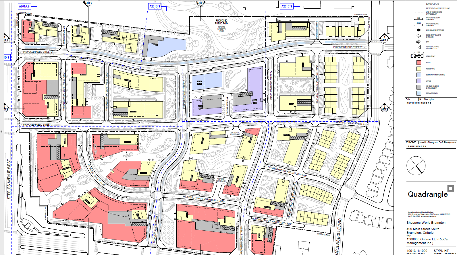
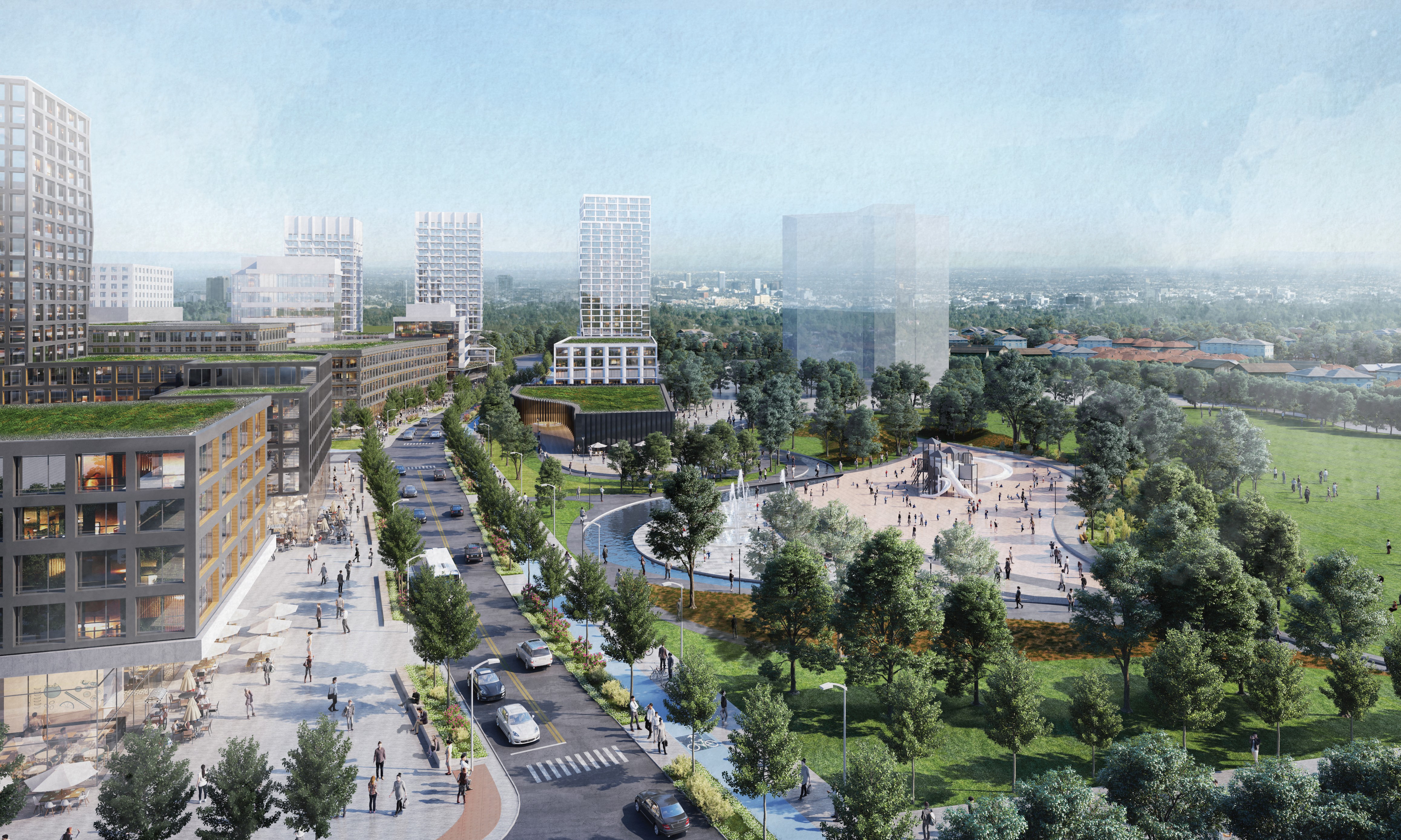
Looking south on Mill Street towards the park expansion and Steeles Avenue. The first phase tower is shown in the middle background.


  • The future of Downtown Brampton

    IMG_6142-001
    Metrolinx-owned houses on Railroad Street, Brampton

    Over the last three years, I have been following developments in Downtown Brampton, especially lands surrounding the Brampton GO Station. In April 2016, Metrolinx, the provincial agency responsible for GO Transit, began buying properties in the northwest corner of Brampton’s downtown core, including twelve houses and two low-rise office buildings. The land assembly was for a new surface parking lot, an odd choice for a transit agency that was otherwise interested in promoting compatible land use and transit connections in designated urban centres.

    It was later revealed that Metrolinx, Ryerson University, and the City of Brampton were working on a new downtown satellite campus, with the main academic building to be constructed on part of the GO parking lot, north of the rail corridor. While the construction of more surface parking in a downtown core was still a bad idea, at least there was a reason behind the land assembly. The new Ryerson site would make use of other city resources, such as the Rose Theatre and the planned Centre for Innovation (CFI). The CFI would include academic space and a central library, to be built on city-owned land south of the GO station and bus terminal.

    university map
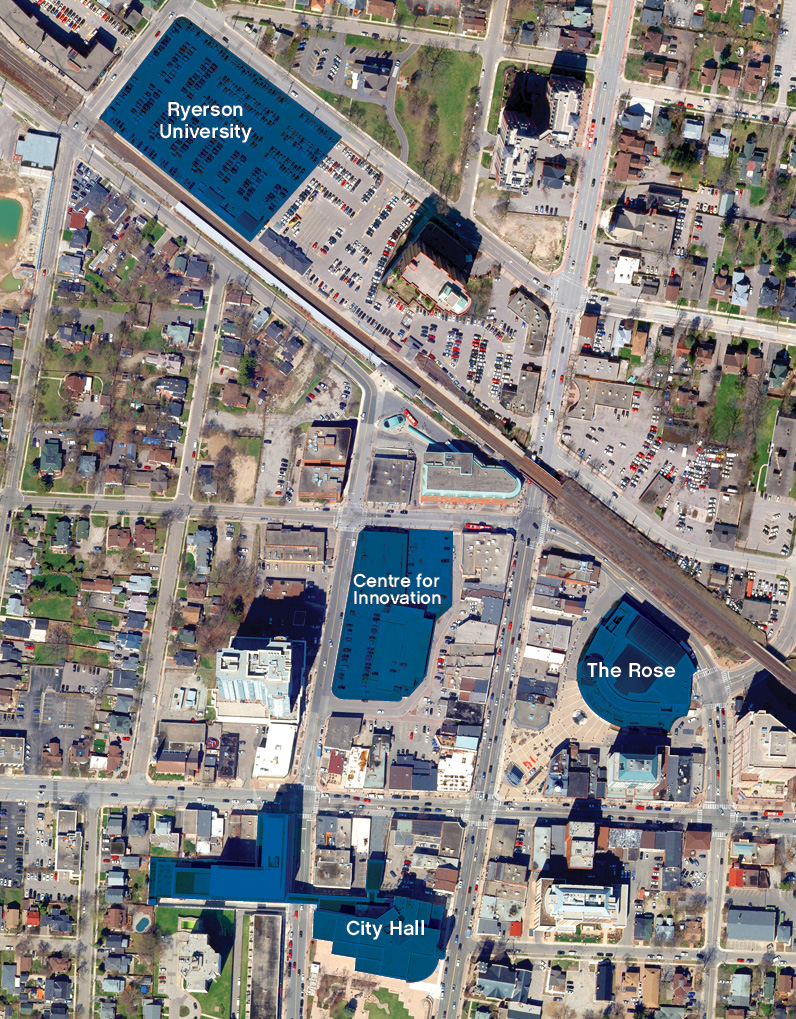
Previous plans for Downtown Brampton, including the Centre for Innovation and the Ryerson campus on the GO Transit lot. Replacement parking would be built on land assembled south of the rail corridor. 

    In October, the newly elected Conservative government cancelled provincial funding for Brampton’s Ryerson campus, as well as other suburban satellite universities planned in Markham and Milton. While Brampton and Ryerson decided to continue working on a scaled-back development including a new centre for cybersecurity, a new plan was developed for downtown revitalization. Details are available in the May 15, 2019 Committee of Council agenda.

    Here’s a simplified summary of the new plan:

    • The CFI will now be built on the north side of Nelson Street West, between Main Street and George Street, on the site of the existing downtown bus terminal, a 6-story office building constructed in 1989, and an older two-storey commercial block. The office building, though only thirty years old, is reported to be in poor condition. The new 15,700 square metre (170,000 square feet) CFI will include the central library, education space, event space, and retail. It may also include additional floors for offices.
    • The bus terminal will be expanded, as the existing facility is too small to accommodate GO and Brampton Transit buses. There will also be room for a new third track through Downtown Brampton, essential for frequent two-way GO service between Toronto, Brampton, and Kitchener.
    • The City of Brampton will likely build a temporary terminal on the south side of Nelson Street to accommodate the demolition of the existing structures and the construction of the CFI and terminal. This land, also owned by the city, is currently occupied by a surface lot and an old commercial building that was originally a Loblaws store. Retail tenants are being evicted from all of the above properties.
    • The city is also interested in using the two office buildings purchased by Metrolinx for short-term academic and administrative purposes as the new CFI is being built.
    • The houses on Nelson, Elizabeth and Railroad Streets acquired by Metrolinx will still be torn down, but without the imminent construction of the Ryerson building, a new parking lot is no longer planned. It is possible that the block will see transit-oriented development in the long term.

    IMG_6155-001
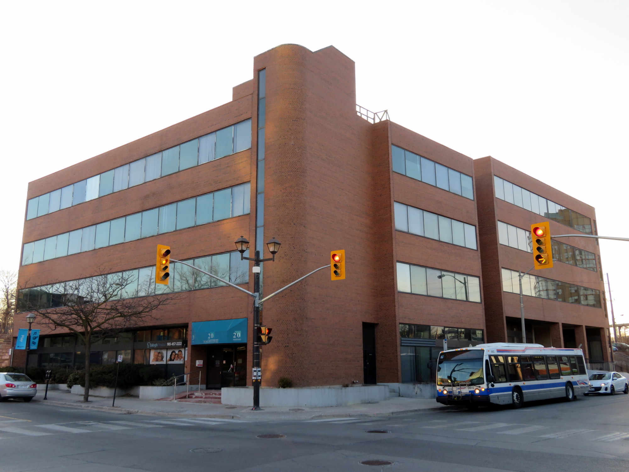
Vacated office buildings at George and Nelson Streets that may see new life under the city’s new plans

    The map below illustrates the revised downtown plans.

    It remains a shame that Metrolinx decided to buy up a whole city block and displace dozens of residents (among the properties it acquired were two heritage houses and a rooming house), especially now that the Brampton Ryerson campus is being scaled back. But the city desperately needs a central library, and happily, Ryerson remains interested in partnering with Brampton. It’s good to see that transit expansion, including a larger bus terminal and GO rail expansion, are part of the plans.

  • What’s next for Downtown Brampton?

    IMG_6148-001
    Boarded up houses on Elizabeth Street, Downtown Brampton

    Earlier this year, the provincial government announced the location of Ryerson University’s Brampton campus, a partnership with Sheridan College, to be built on the GO Station parking lot in Downtown Brampton. Meanwhile, Metrolinx quietly purchased several houses and office buildings south of the station for new GO Transit surface parking, replacing the spots that Ryerson will build upon.

    The merits of a satellite university campus are open to debate – some smaller satellite campuses have struggled to attract students and faculty and distinguish themselves. Brampton’s the planned campus site was, by far, the best one for both the City of Brampton and Ryerson University.

    But today, the Progressive Conservative provincial government, elected in June, cancelled three planned suburban post-secondary education campuses — the York University/Seneca College campus in Markham, the Wilfrid Laurier University/Conestoga College campus in Milton, and the Ryerson University/Sheridan College campus in Brampton.

    This announcement came only one day after the October 22 municipal elections. While Toronto elected a smaller 25-ward council and returned John Tory to the mayor’s office, the voters Brampton elected former Ontario PC leader Patrick Brown as mayor, narrowly defeating incumbent Linda Jeffrey. Brown had just moved to Brampton after his campaign for the elected Peel Region Chair was cancelled at the same time Brown’s successor as PC leader, Premier Doug Ford, imposed the new 25 ward structure on Toronto. We can only speculate if the animosity between Brown and Ford was a factor in this announcement. It’s more likely that the decision to cancel the three campuses was already made, with the announcement timed to take place after the municipal elections. In any case, mayor-elect Brown’s job has already become more interesting.

    Brampton’s satellite campus, which had a 2022 opening date, would have hosted 2,000 undergraduate students. Though this is tiny compared to Ryerson’ downtown campus, which 36,000 undergraduate students currently enrolled, it was the best possible site, adjacent to the GO station, several Brampton Transit routes, the Rose Theatre, and local shops and restaurants and recreation facilities. The school would have made use of the the planned Centre for Innovation, a proposed new central library to the corner of George and Nelson Streets.

    university map
    Map of the Ryerson University campus site, the Centre for Innovation, and other downtown buildings. From the City of Brampton website.

    The York University/Seneca College campus in Markham was also strategically located, on a site adjacent to Unionville GO Station, in the mixed-use Downtown Markham development. In contrast, the Milton site was in a greenfield far from transit links. It’s fair to say that I’m not too disappointed on Milton’s behalf.

    With Brampton’s campus dead, for now, there’s still the land on the south side of the station. Three homes are already knocked down, while two office buildings and several houses are boarded up, awaiting demolition.

    Will Downtown Brampton see nothing more than additional GO Transit surface parking now that the campus is cancelled? Or will a new opportunity come along?

    BramptonParkingLot
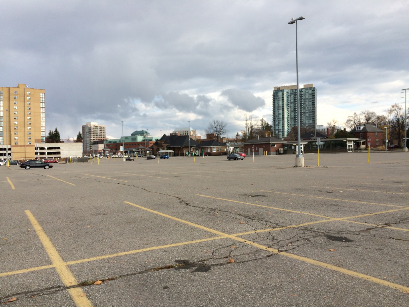
The existing GO Transit lot at Brampton Station, where the Ryerson University/Sheridan College campus was planned

  • Requiem for Ontario’s regional malls

    IMG_8782-001
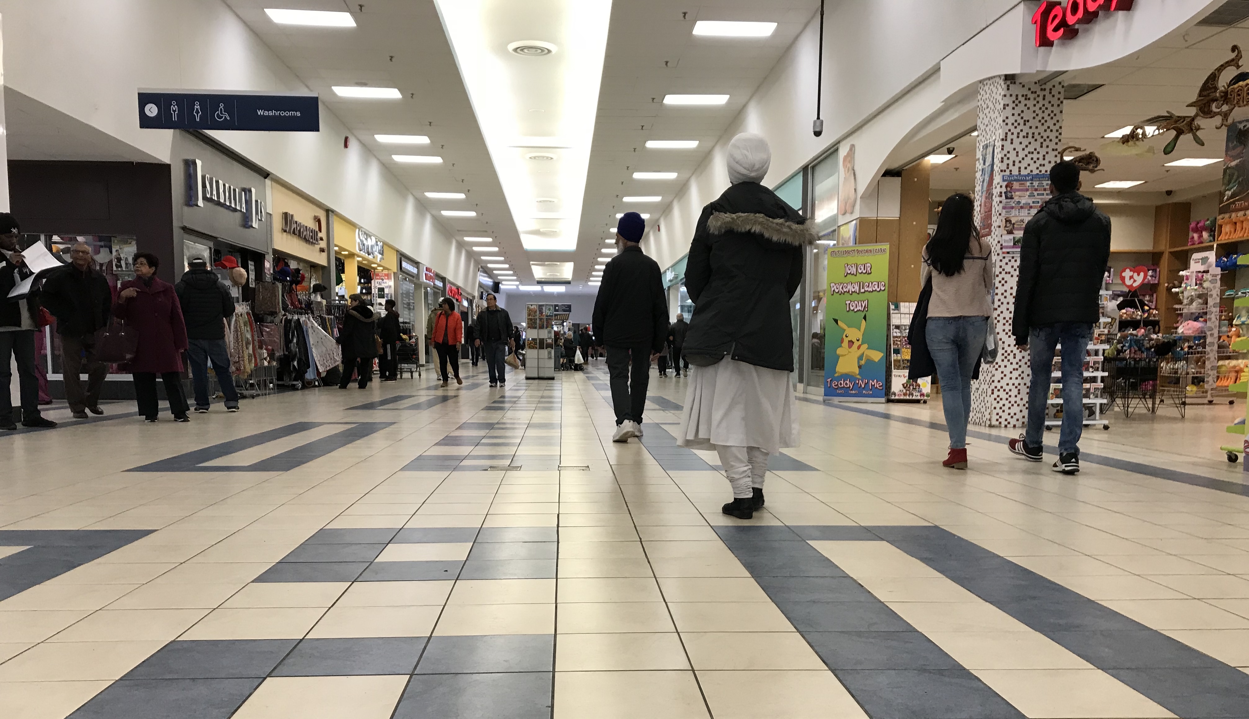
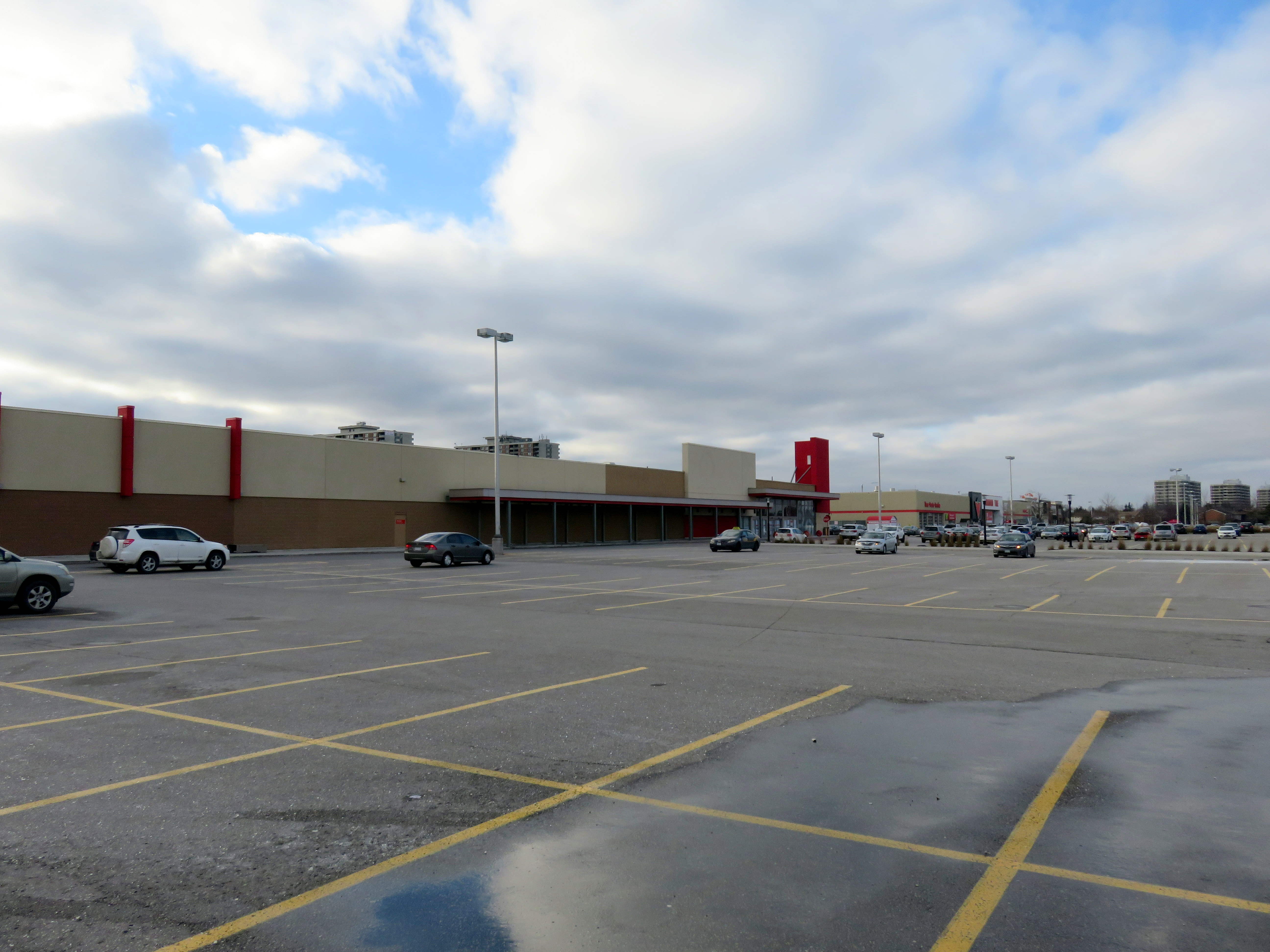
Shoppers World Brampton, 2016, before the Target store was replaced by smaller stores, including Giant Tiger

    Recently, I wrote about the history of Ontario’s downtown malls. Most of these shopping centres, built in the 1970s and 1980s in the downtown cores across the province, failed by the end of the 1990s. The collapse of the Eaton’s department store chain and competition from larger, suburban malls and new big-box retailers drove customers away from Ontario’s downtowns. Only in Toronto and Ottawa, with large downtown office employment, residential development, and good urban transit, did these major shopping malls thrive.

    But that does not mean that all suburban shopping centres are doing well, especially after the loss of Target in 2015 and Sears Canada in 2017. For TVO, I wrote more about how smaller regional malls in Ontario are re-positioning themselves.

    The Brampton house that I grew up in was a ten minute walk from Shoppers World, which, in the 1980s, had a full line department store, Simpson’s, as well as Marks and Spencer, K-Mart (where I had my first paying gig, delivering shopping carts back to the store abandoned in nearby parks), a Pascal hardware store, and two supermarkets, Food City and A&P. Larger, more popular malls like Mississauga’s Square One and Bramalea City Centre were one bus ride away, but Shoppers World held its own, even if it was second tier. By the 1990s, though, it was clear that the mall was in decline: national retailers were leaving and there was a noticeable lack of investment in the property.

    When RioCan REIT purchased Shoppers World in the late 1990s, it made some improvements and attracted big-box retailers like Canadian Tire, Staples, and Winners. Zellers took over the K-Mart store, which was expanded. But The Bay (which replaced Simpson’s) was closed down and the store later demolished. I had left Brampton in 2006, but I was still sad to see my one-time local mall decline. Now RioCan has talked about downsizing the mall, and redeveloping part of the property. Competition from larger, stronger shopping malls, newer retail power centres, the mismanagement of several retail firms, and internet shopping have all taken their toll. Shoppers World isn’t a dead mall, but like many smaller malls, it will be adapting to changing times.

    In the TVO article, I take a look at a few other malls, like London’s Westmount Mall, in similar circumstances.

    ShoppersWorld.jpgShoppers World, 2018. Despite many store vacancies, it’s still a community hub.

  • A tale of two university campuses

    BramptonParkingLot
    Site of Brampton’s new Ryerson/Sheridan campus

    Last week, the provincial government announced two new post-secondary educational campuses in Toronto’s fast-growing western suburbs, due to open in 2022. Wilfrid Laurier University will be partnering with Conestoga College on a new facility in Milton. Brampton will be getting a new Ryerson University campus in partnership with Sheridan College. Both new campuses, each receiving $90 million in provincial capital funding, will be focused on undergraduate STEAM (science, technology, engineering, arts, and mathematics) programs. Both will host up to 2,000 students once the new facilities are fully operational.

    Despite the many commonalities between the new Milton and Brampton facilities, the announced campus locations could not be any more different. Milton’s Laurier/Conestoga campus (which I previously wrote about as an example of the problems of greenfield institutions) will be located on a new greenfield site on the southwestern outskirts of the town’s built-up area, while Brampton’s Ryerson/Sheridan campus will be located in that city’s downtown core, on a site currently used for commuter parking. But since GO Transit’s free commuter parking has to go somewhere, Metrolinx has been buying up and demolishing houses and offices on a nearby downtown block.

    I compared the two new campuses for TVO

  • Ontario’s failed downtown malls

    IMG_0392.JPG
    Bayside Mall, formerly the Sarnia Eaton Centre, on a Saturday morning in 2013. Most stores are vacant or occupied by non-profits or independent businesses.

    The Toronto Eaton Centre, large, famous, and vital, is only one of many malls built in the downtown cores of Ontario cities between the 1960s and 1990s. From Thunder Bay to Cornwall, the construction of new enclosed shopping centres were seen as a necessary tool to keep the old city centres vibrant and relevant in the face of competition from new suburban malls. But only in the province’s two largest cities did the concept work. Elsewhere, these urban shopping complexes were left largely vacant within ten years of opening, when leases expired. When the Eaton’s department chain went bankrupt in 1997, huge voids were left behind that developers and municipalities struggled to fill.

    The Toronto Eaton Centre was opened in two phases between 1977 and 1979. It added hundreds of shops and new office space to Downtown Toronto, anchored by a new Eaton’s flagship and was connected to the Simpson’s store across Queen Street. Today, the Eaton Centre is Canada’s second largest mall (including the Hudson’s Bay/Saks Fifth Avenue building) and the Toronto region’s second most productive shopping centre in terms of sales per square metre. In Ottawa, the downtown Rideau Centre, opened in 1983, is the busiest and most productive mall in that region (Retail Council of Canada, 2016).

    But elsewhere in Ontario, downtown malls — mostly built with municipal and/or provincial government support — have been, without exception, commercial and urban development failures. Not only did they suffer from high vacancy rates, they helped to wreck the downtown cores they are located in rather than foster the economic revitalization they once promised.

    (more…)