Category: Transit

  • How to run a street railway: riding trams in Central Europe

    How to run a street railway: riding trams in Central Europe

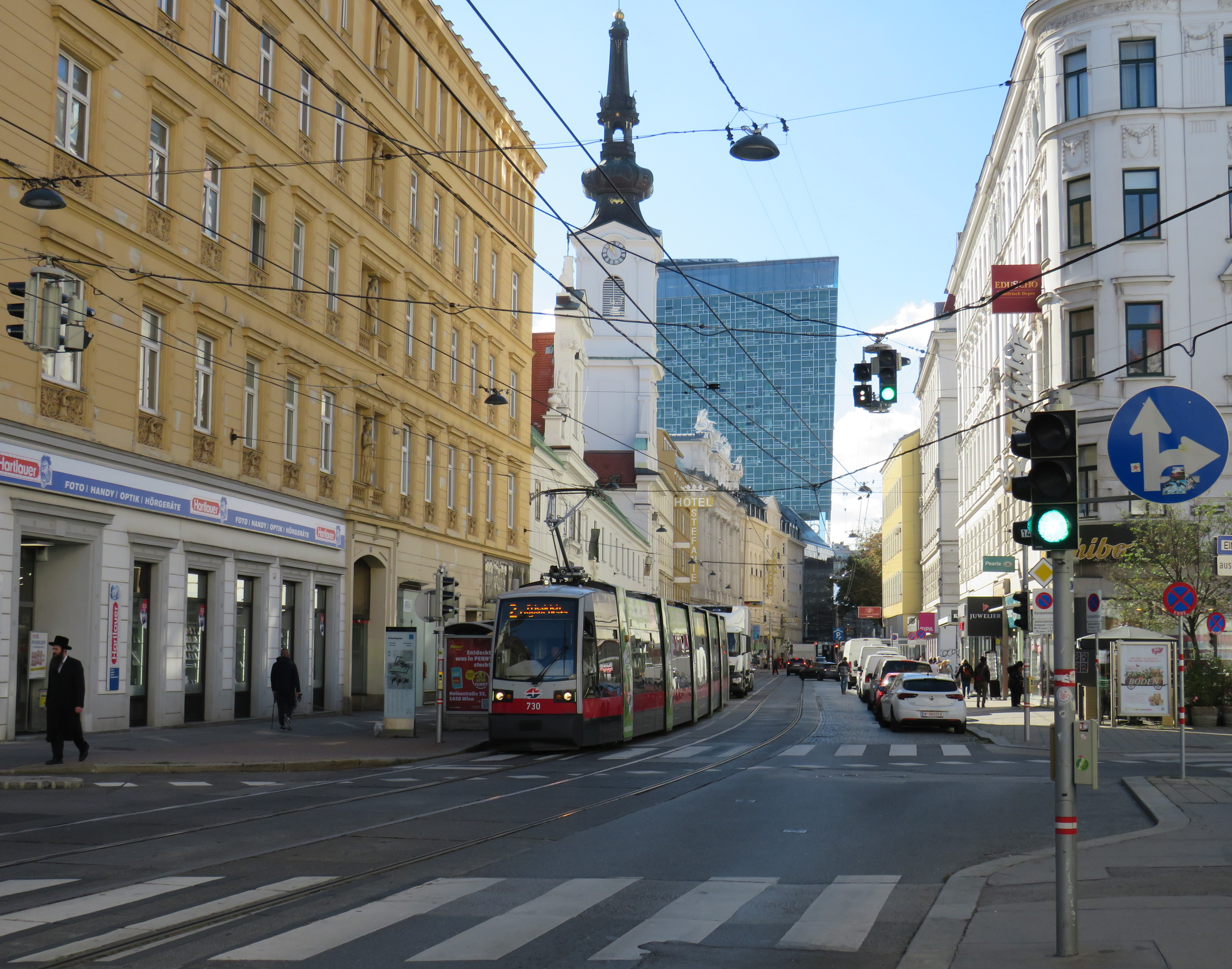
    Vienna low-floor tram in the Leopoldstadt district

    Back in October, my spouse and I had the opportunity to visit several countries in Central Europe: Austria, Slovakia, Hungary, and the Czech Republic, though we spent the majority of our time in and around Vienna, as that is where my spouse attended business meetings for several days; we also took time to explore the city and surrounding areas together.

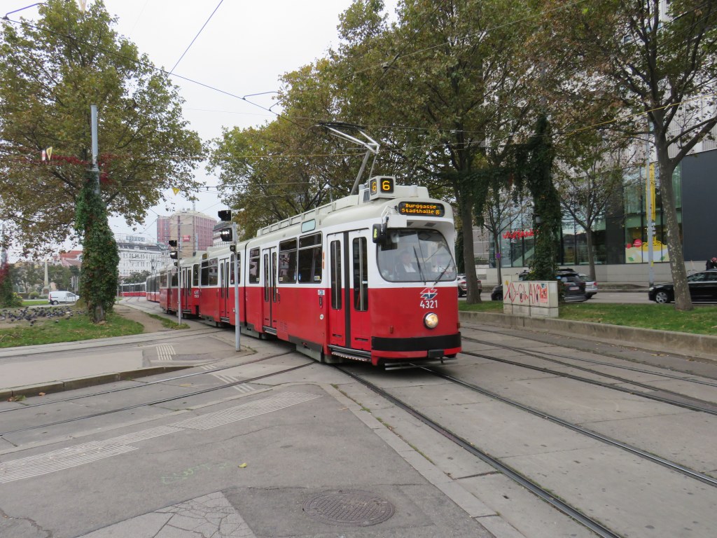
    While there, I experienced how serious cities operate trams seriously. In Bratislava, I saw how a streetcar priority corridor can work in a busy downtown core. In Prague, trams made it through watermain construction zones without detours or unreliable bus shuttles. In Budapest, I rode the world’s longest trams that move more people per hour than many metro lines. In Vienna, where I spent the most time, I experienced a city where transit passengers are treated with respect, and where the trams are reliable, despite no discernable signal priority and plenty of mixed-traffic operations.

    Vienna is an amazing city to visit. It’s been described to me as “what people think Paris is.” That’s pretty much true. It’s a very walkable city with a fantastic café culture full of independent konditorei cafés (which offer sit-down service), with an assortment of rich, tasty cakes and great coffee. It has great art galleries and grand imperial palaces, but without the crushing crowds of Paris and Versailles. As the original Music City, it’s easy to find shows and performances to suit your tastes. (We attended the famous Wiener Staatsoper, where I took in my first live opera, ever, at a surprisingly reasonable price). It’s also a compact city, easy to walk, though the transport system is excellent. Vienna is also a great base for visiting other cities in Central Europe, where Salzburg, Bratislava, Budapest, and Prague are only a few hours away by (frequent and relatively speedy) train.
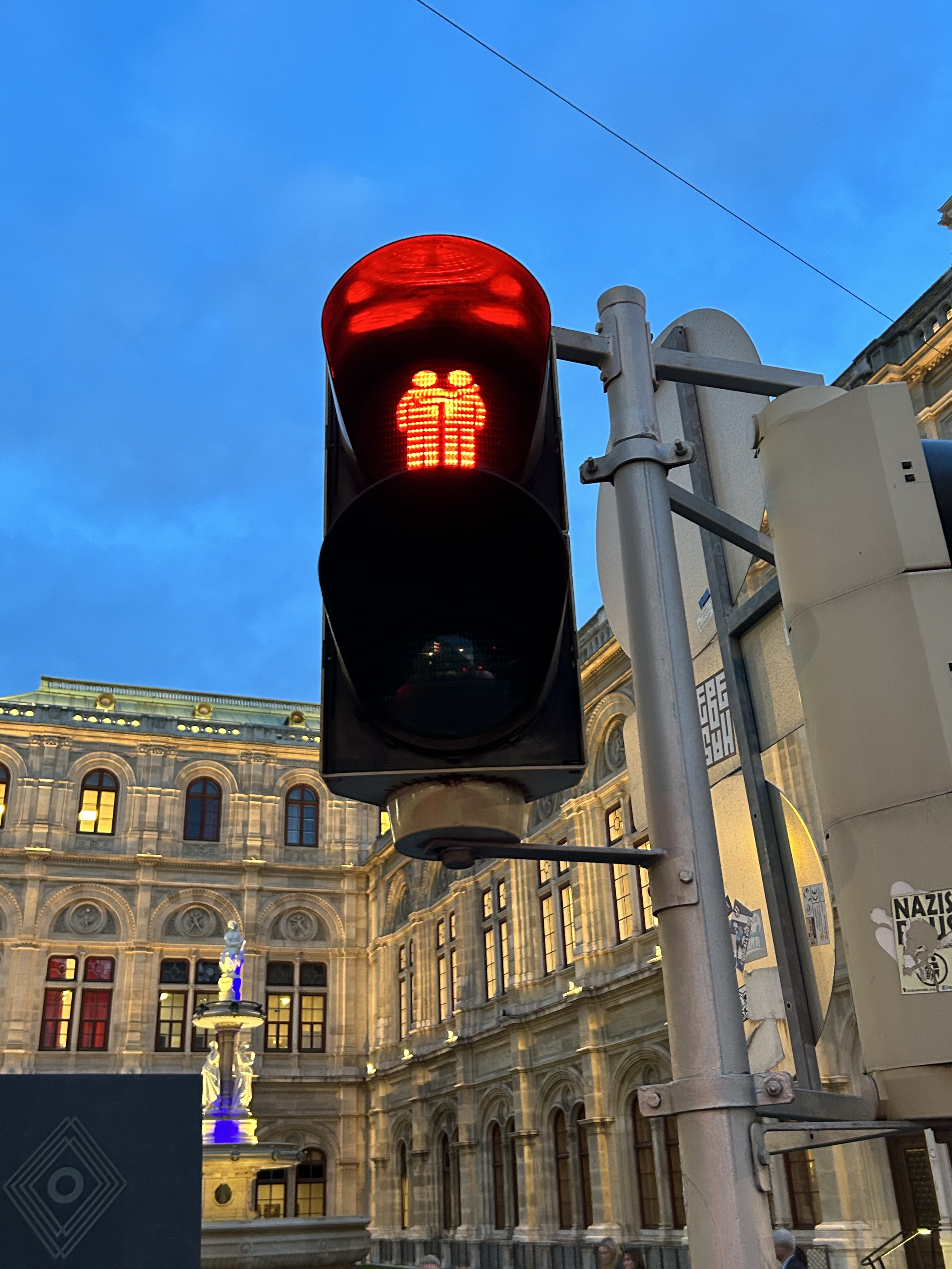
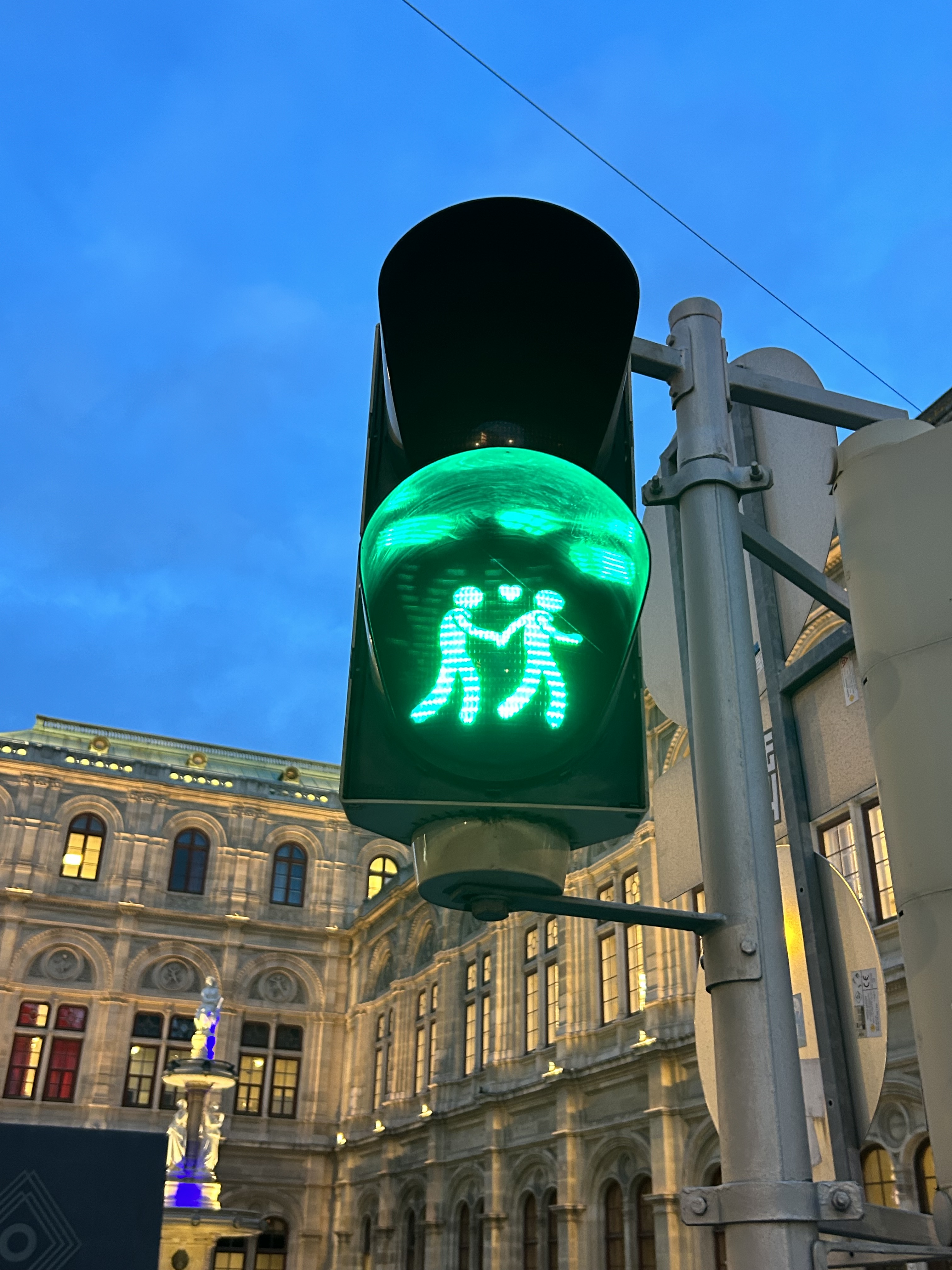
    We noticed several pedestrian signs showing loving couples, rather than the standard, like this one in front of the Wiener Staatsoper (Opera House)

    Vienna has one of the largest tram systems in Europe, with 30 lines over 176.9 kilometres, and a fleet of 525 cars, including modern articulated LRVs and older trams and trailers. In Vienna, trams alone carry approximately 300 million passengers a year. They run in many different environments: on-street in mixed traffic, reserved lanes, dedicated median and side-of-street rights-of-way; there is also a tram tunnel south of the city centre. Until the 1980s, Straßenbahnen (the German name for trams) were the backbone of Vienna’s transport network, with a small Stadtbahn system (now incorporated into the modern U-Bahn) and regional and suburban (S-Bahn) trains providing limited rapid transit services. Though there are now five U-Bahn lines (two of which evolved from the Stadtbahn), the tram system remains robust and very useful for getting around.

    Like all four cities mentioned in this post, Vienna operates a mix of low-floor trams built in the last 25 years, as well as older high-floor trams, many of which are accompanied by an unstaffed trailer. Vienna’s entire network — trams, buses, U-Bahn, and S-Bahn — is a proof-of-payment system. Fare inspections appeared to be infrequent; neither my spouse nor I were checked during our eight days in Vienna. Tickets and passes can be purchased from a machine (found at every U-Bahn entrance and at many tram stops) or on the WienMobil app.
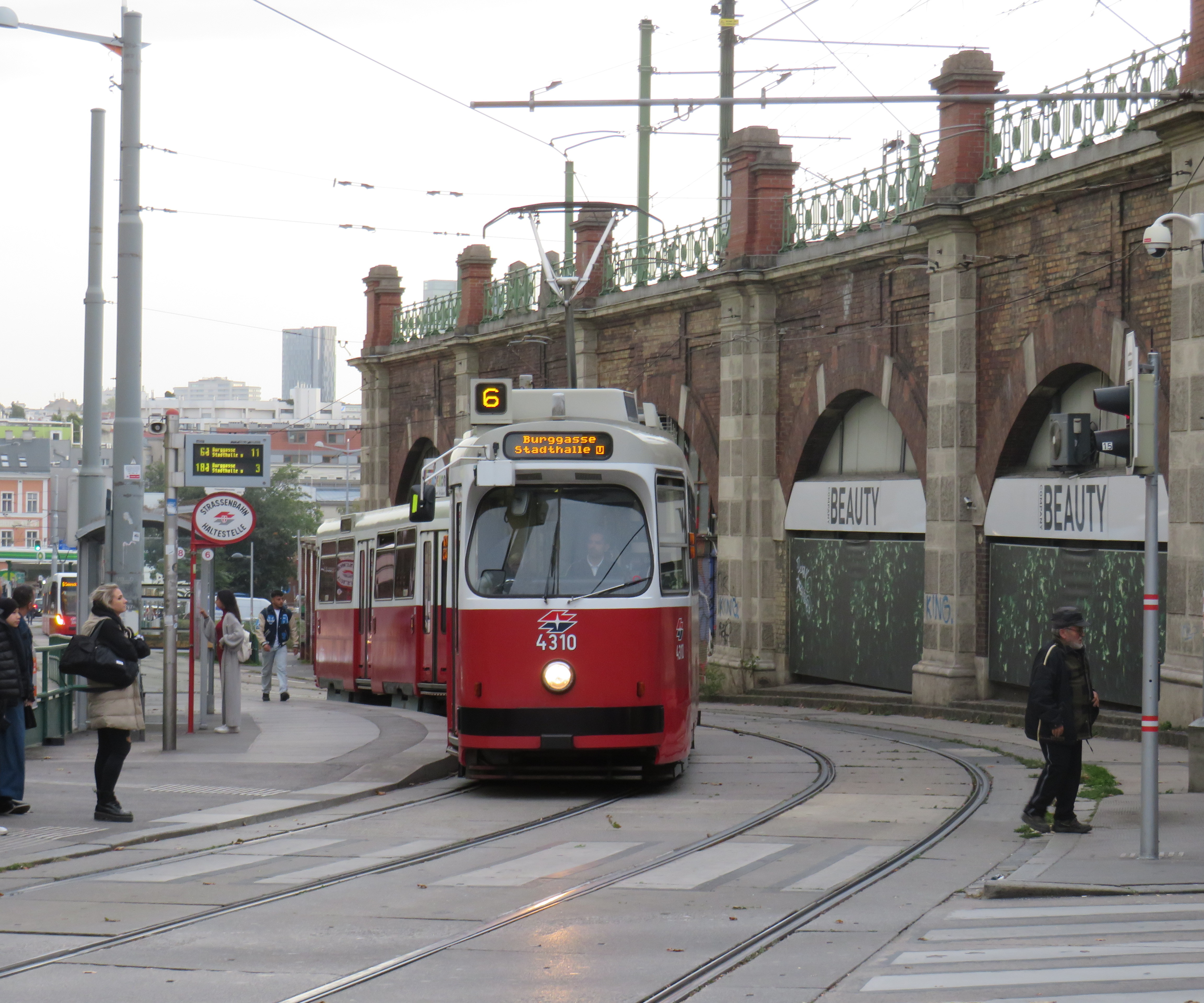
    An older Type E2 high-floor tram and trailer at Gumpendorfer Straße. Behind is the old Stadtbahn viaduct, which is now part of Line U6. Note the large red “Strassenbahn Haltestelle” sign to the left, a classic Viennese icon that indicates a tram stop.

    There is also a separate interurban tram service called Badner Bahn, which extends to the historic spa town of Baden bei Wien, an hour south of Vienna’s city centre.
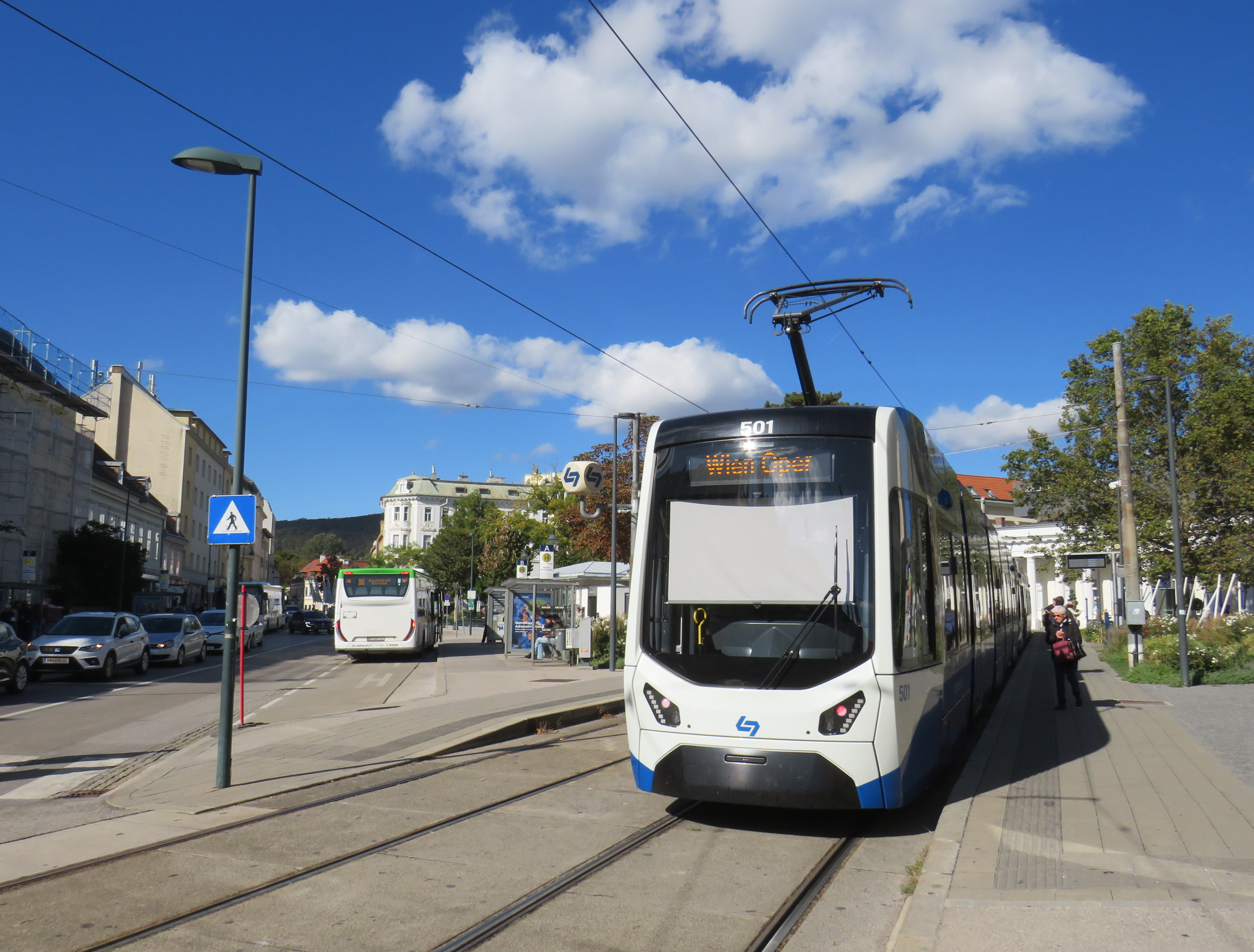
    Badner Bahn tram, laying over at Josefsplatz in Baden bei Wien

    The modernized interurban originates in the heart of Vienna — across the street from the Wiener Staatsoper (Opera House) — then along local tram tracks and through the tunnel before entering its own right-of-way through the southern suburbs, and onwards through small towns, farms, and vineyards before arriving in Baden. There are several spurs leading to local industries; the regular passenger service shares the tracks with local freight trains.
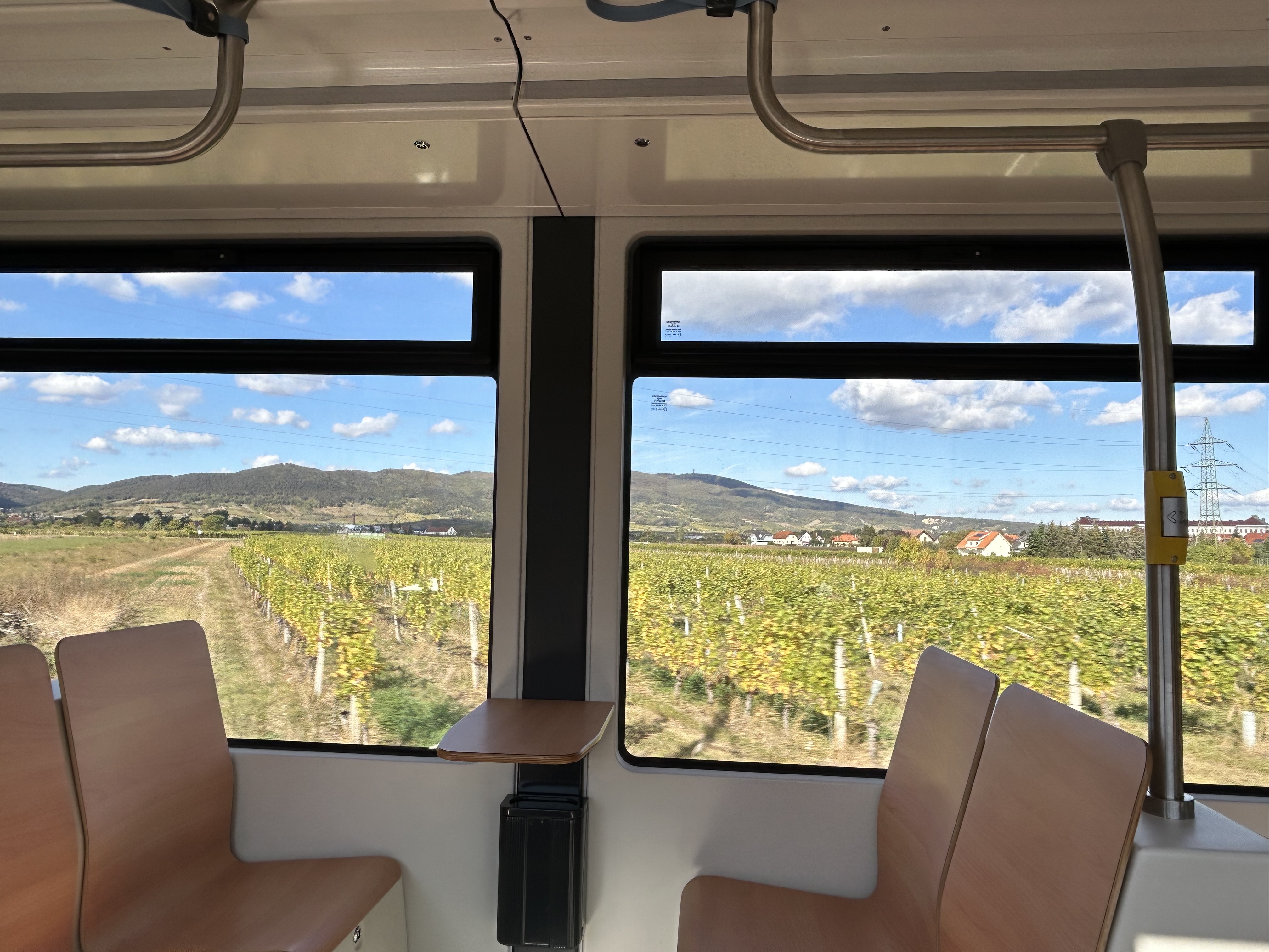
    View of the vineyards from Badner Bahn
    A sample of the journey aboard Badner Bahn. Arriving southbound at Guntramsdorf, heading towards Baden bei Wien.

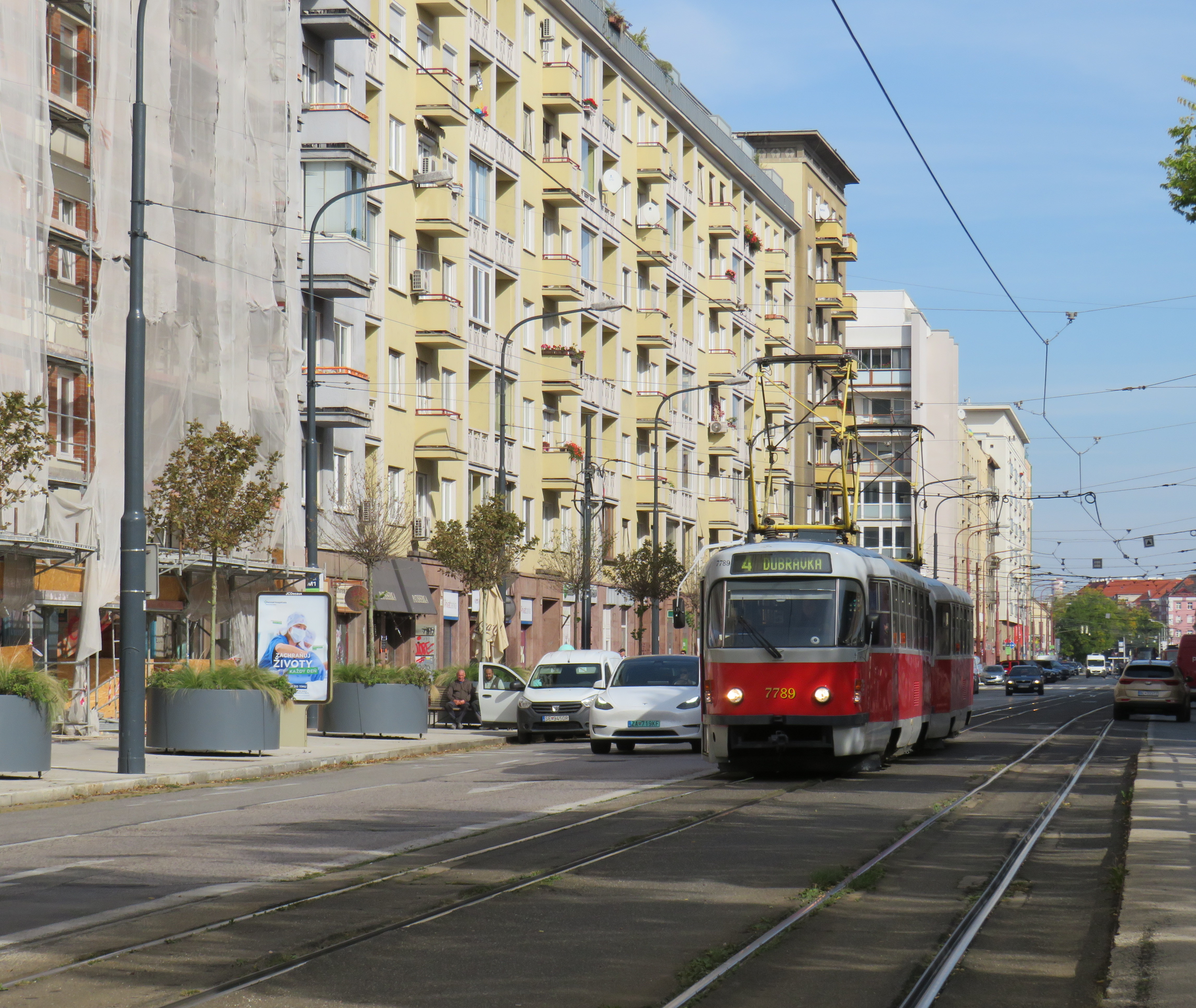
    Bratislava, just over one hour away from Vienna by train (or by catamaran), is served by a network of metre-gauge trams, trolley buses, and diesel buses, though trams predominate in the city centre. On Obchodná, several tram lines, pedestrians, cyclists, and the occasional delivery or emergency services vehicle share a narrow, but busy shopping street. It just works.

    Obchodná, Bratislava

    Outside the congested urban core, trams are afforded reserved lanes, sometimes separated from general traffic with curbs (and even grass medians), sometimes just painted lines. Bratislava’s tram system is smaller than Toronto’s, with 211 cars and 42 kilometres of revenue track, carrying around 70 million riders a year in 2019 (Toronto’s streetcars carried 108 million that year). It is also a much smaller city, with a population of around 660,000. I only visited Bratislava for a day, but I got to ride much of the tram network; I found it an easy and convenient way to get around.
    Reserved, painted tram lanes just outside Bratislava’s city centre

    Budapest, Hungary has the largest street railway system in the world by ridership, with Route 4/6 on Budapest’s Grand Boulevard (Hungarian: Nagykörút), often cited as the world’s busiest tram line. Route 4/6 also operates 53.99 metre long Combino Plus trams, which, when introduced in 2006, were the world’s longest. The Combinos are almost twice the length of Toronto’s new Bombardier Flexity cars, which are 28 metres long. Even with the huge capacity these trams have (they require two pantographs to draw enough power to operate), they operate on Line 4/6 every few minutes, all day long, every day.
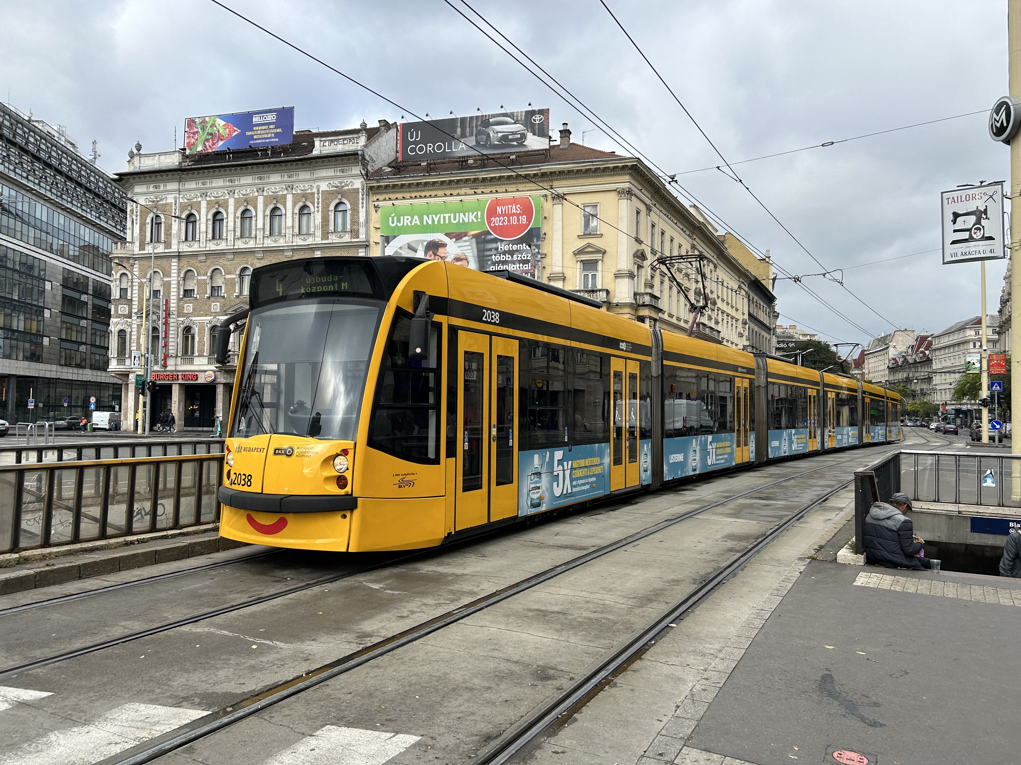
    A Combino Plus tram on Line 4 traverses Budapest’s Nagykörút (Grand Boulevard)

    Through the 1970s and 1980s, Budapest’s tram network was slowly cut back in favour of buses, trolley buses, and metro construction. By the 1990s, however, there was a street railway renaissance in Hungary’s capital because of the capacity and economy trams offered. With high frequencies, a private median, and high-capacity low-floor vehicles, Line 4/6 easily matches the capacity of a metro, at comparable speeds. Elsewhere, dedicated lanes and private rights-of-way make it clear that transit riders come first.
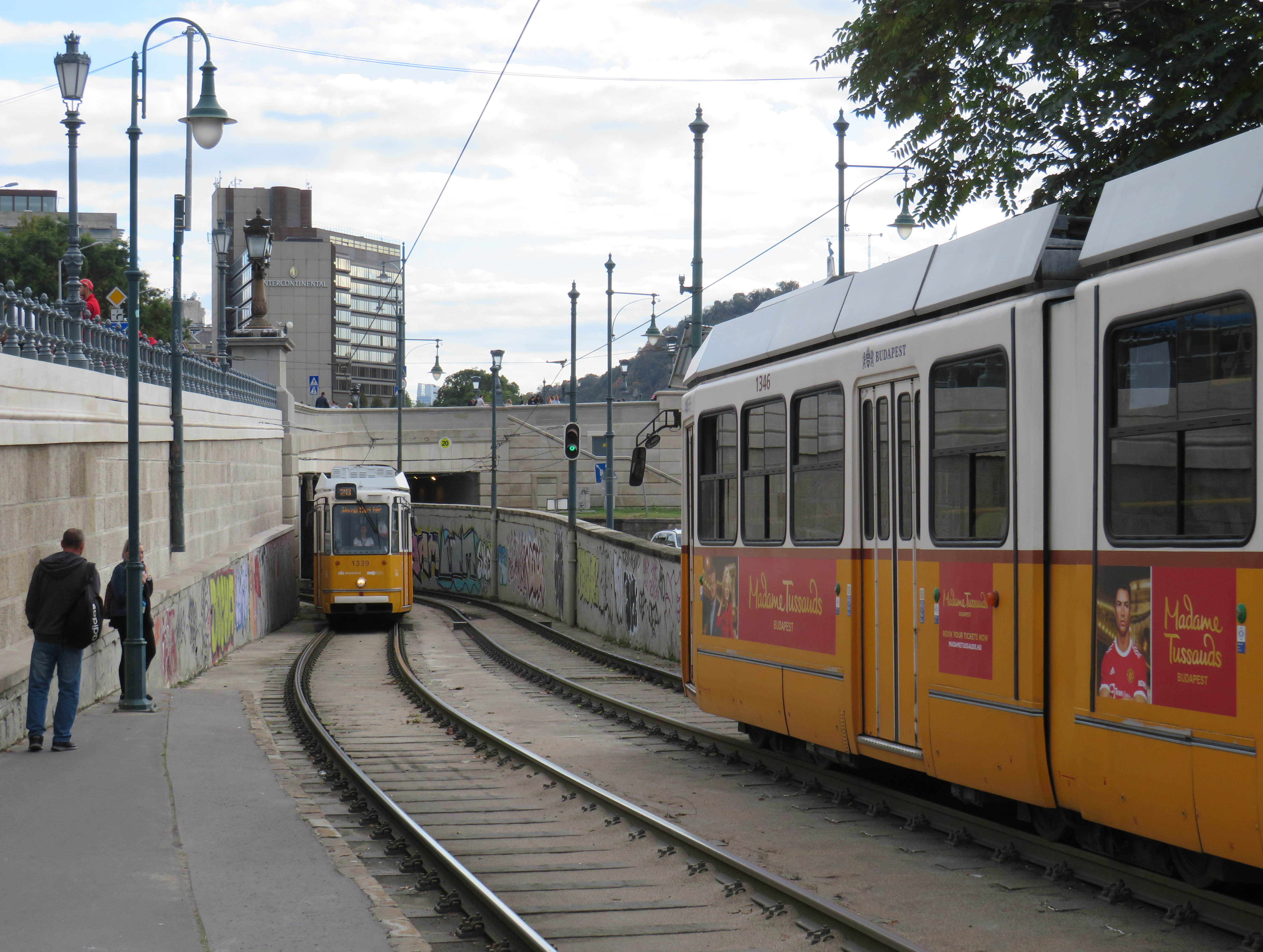
    Older trams running along the Danube dip under road bridges on a private right-of-way

    Though Budapest has a large metro network, most of it was not constructed until the l970s and 1980s. However, Line M1 was opened in 1896 as a shallow subway under Andrássy Avenue, the first electric underground metro in the world, and only the second subway, after London’s initial Underground line. Uniquely among urban transit routes, it it is listed as part of an UNESCO World Heritage Site.
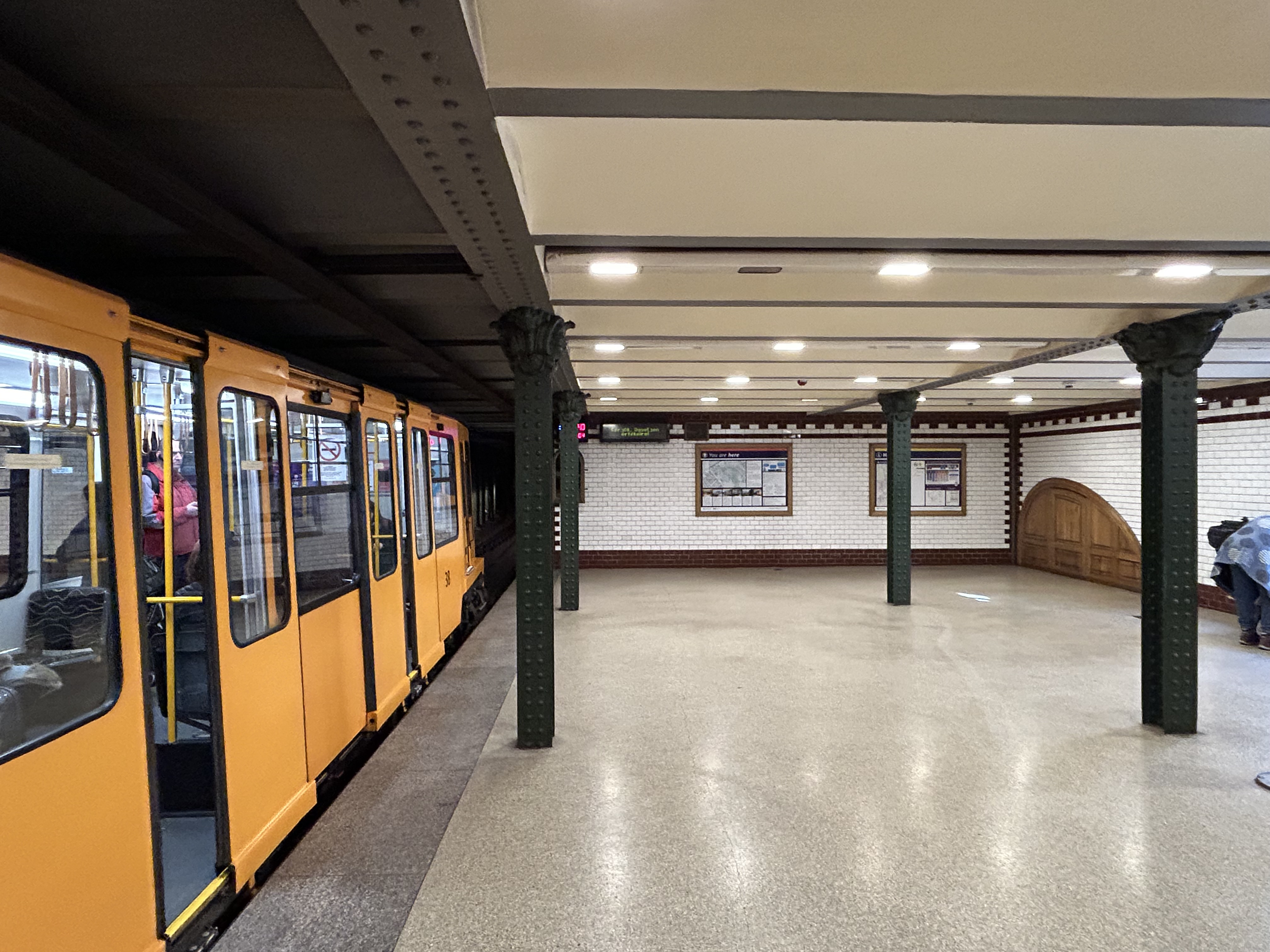
    Budapest Line M1 stations, restored to their original appearance, look like miniature New York stations, only cleaner

    Finally, in Prague, we took several trams to take shelter from the rains that greeted us after arriving from Budapest, but also to see the city outside the crowded tourist spots. We took Line 1 from the city centre to the suburban district of Hrdlořezy, and returned via Line 9, taking a slightly different route back. Like Budapest, a metro system was planned and built in the 1970s and 1980s, but trams remained important, often providing local services parallel to deep underground metro lines.
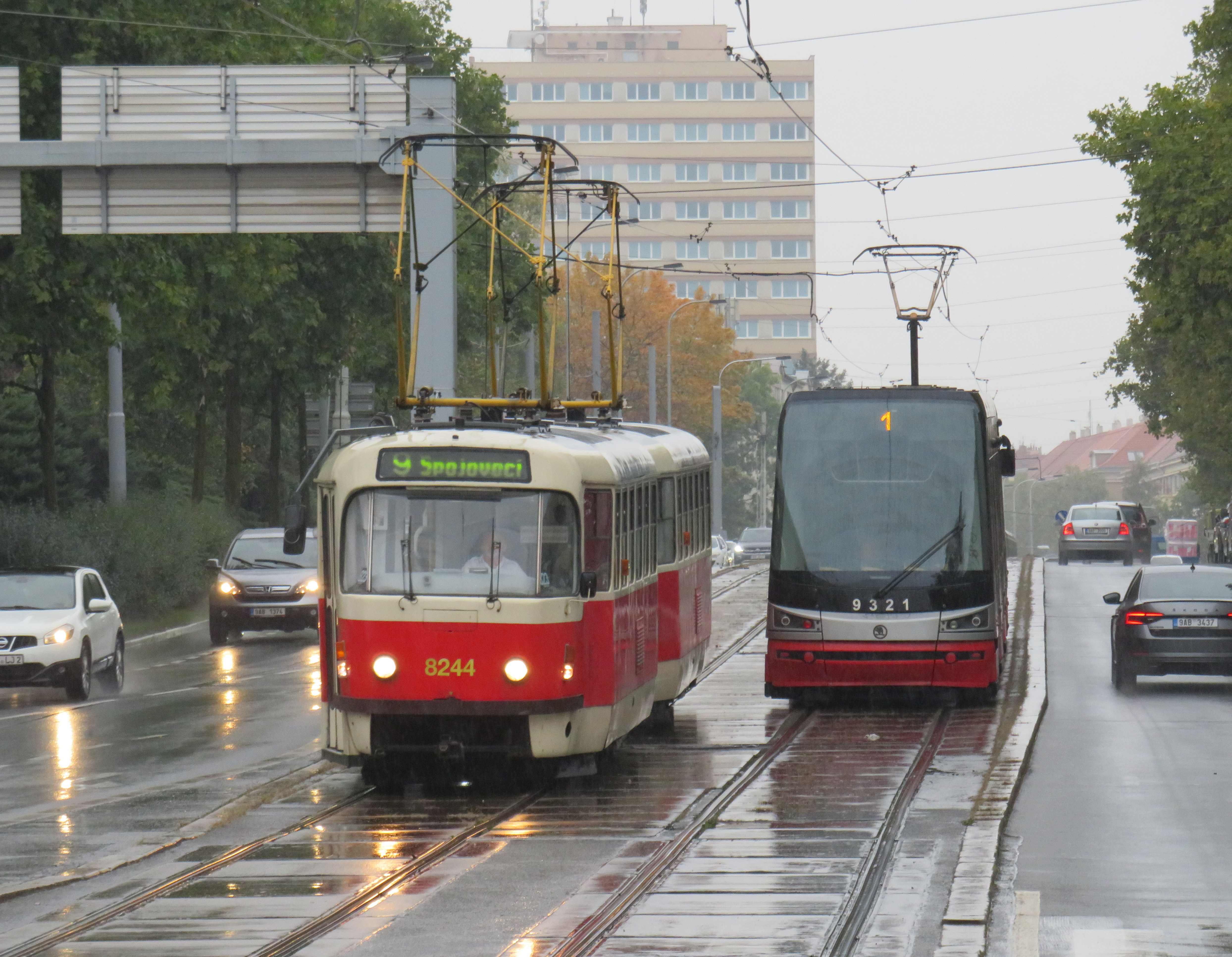
    Old two-car tram train on Line 9, passing a newer low-floor tram on Line 1, Sokolovská, Prague. Most trams run on reserved rights-of-way.

    What interested me was seeing major watermain work along the line. Through trams slowed where work was adjacent, there were no diversions or shuttle buses. The trams ran through.
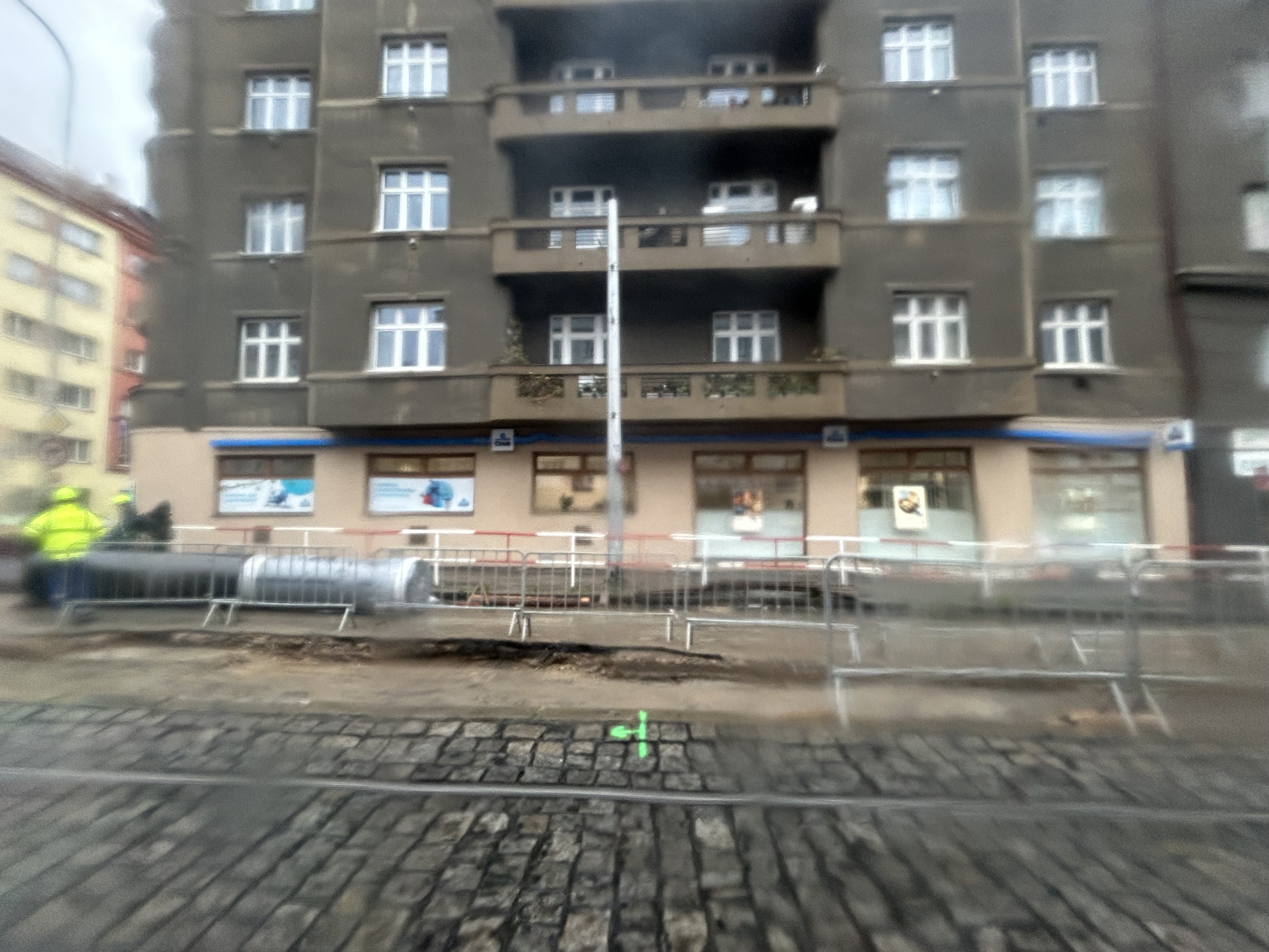
    Watermain replacement in Prague, with trams still running (taken on a rainy morning)

    Like Vienna, Bratislava, and Budapest, Prague operates a mixed fleet of older high-floor trams and modern low-floor light rail vehicles, similar to Toronto’s new fleet. But in Prague, heritage trams could often be spotted in service, especially on the west bank of the Vltava near Prague Castle.
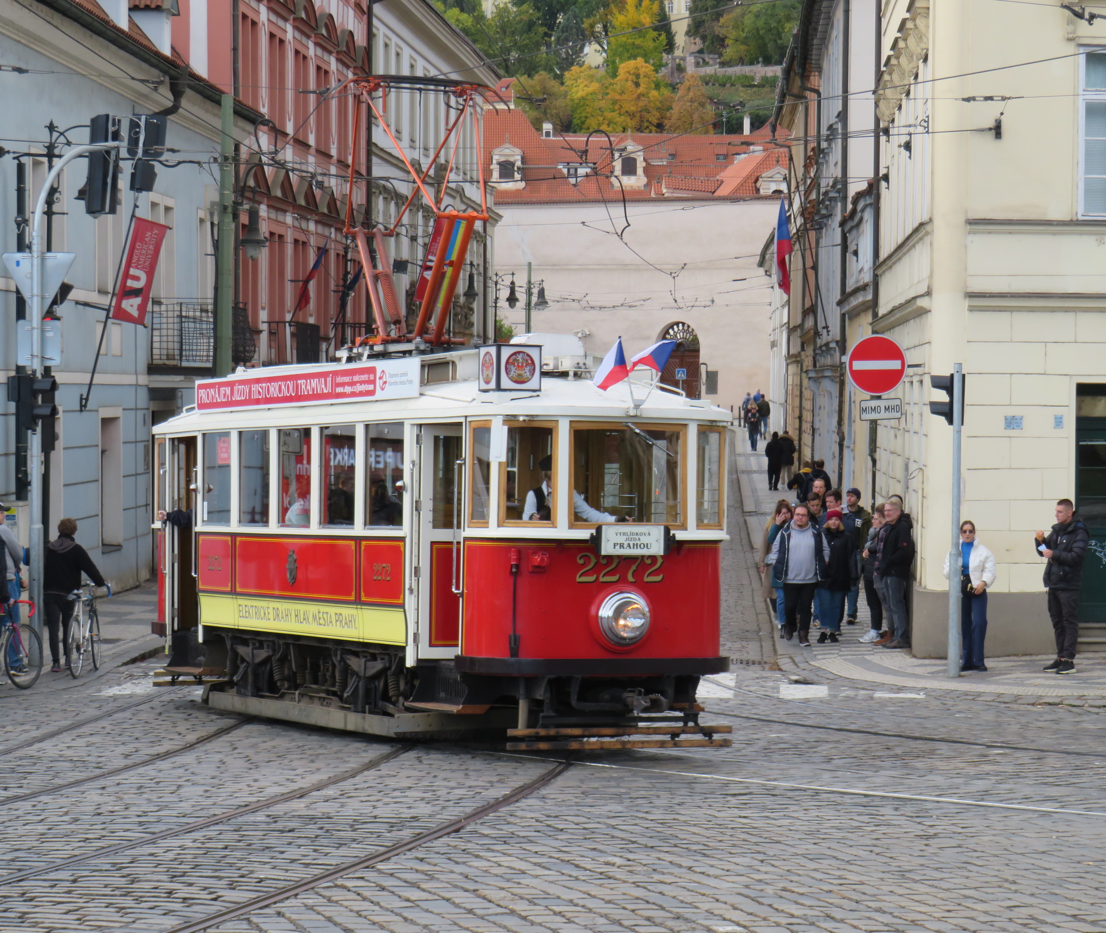
    Heritage tram #2272 in Prague

    Lessons for Toronto

    After travelling, it can be easy to spot one’s hometown flaws and faults. But I spent a lot of time riding Vienna’s metros, trams, and buses, and mindfully experiencing the transport networks in Bratislava, Budapest, Prague, and Salzburg (which does not run trams, but has a large trolleybus network), I was left with some key takeaways on how to do transit here.

    First and foremost, transit riders were respected. Not necessarily in terms of personable customer service, but the feeling that the next tram or bus was going to arrive on time, and a reliable interval. If there was a delay, it was very well communicated.

    For instance, while waiting for a tram in Vienna, we experienced an unusually long wait. The next tram display kept showing the next two arrivals at 3 and 4 minutes. Not long after, a voice came on a loudspeaker posted above the tram stop sign announcing (in German, translated in English to us by one of my spouse’s colleagues) a delay because of a collision along the route. The blockage cleared after a few minutes, and we boarded a crowded tram. I appreciated the audio announcement, especially as it was a basic tram stop.
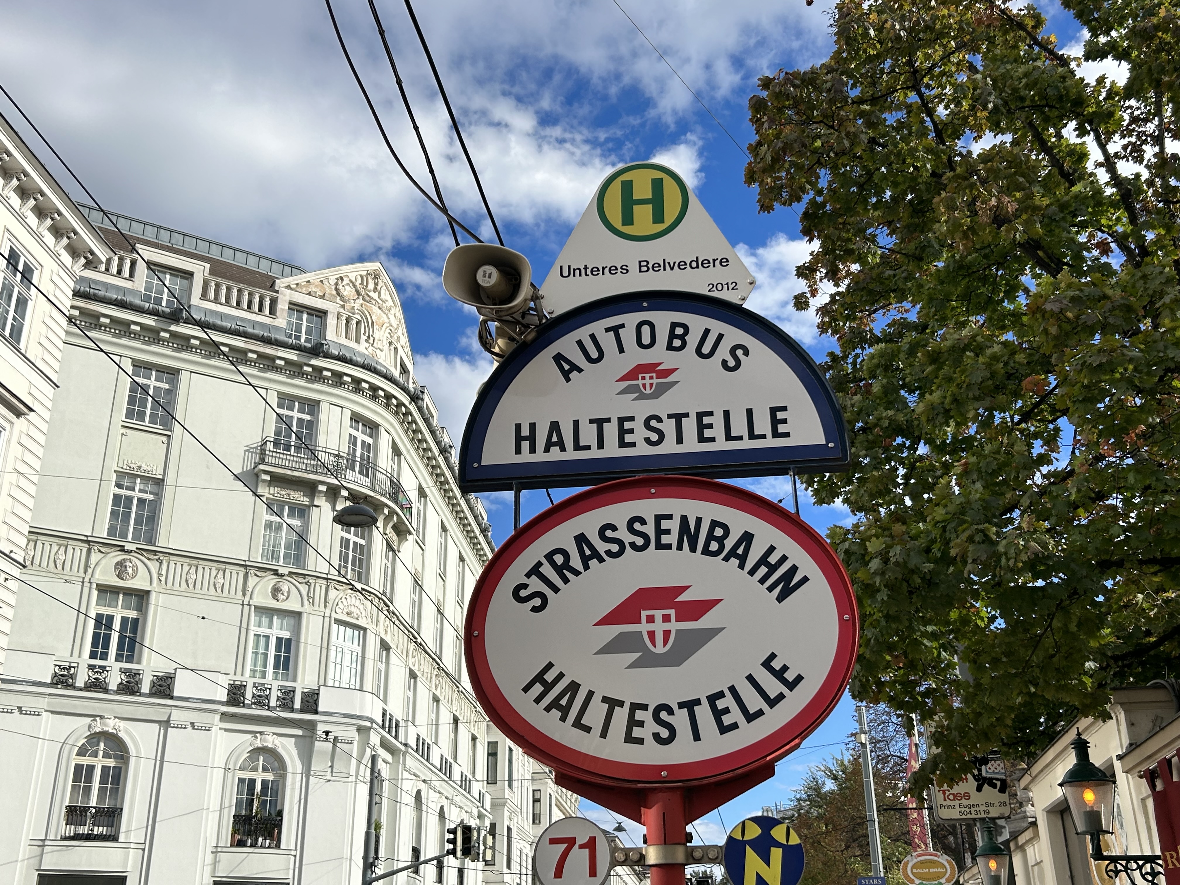
    The classic Vienna tram stop. Note the loudspeakers atop the blue bus stop sign (at night, buses take over, hence the Strassenbahn and Autobus stop signs).

    Next vehicle displays were common in every city we visited. They would list — in real time — the next several buses or trams, as well as if the vehicle was low-floor accessible or not with a wheelchair symbol. All buses are now fully accessible, but the information is useful for the tram lines, where there are still many older high-floor vehicles.
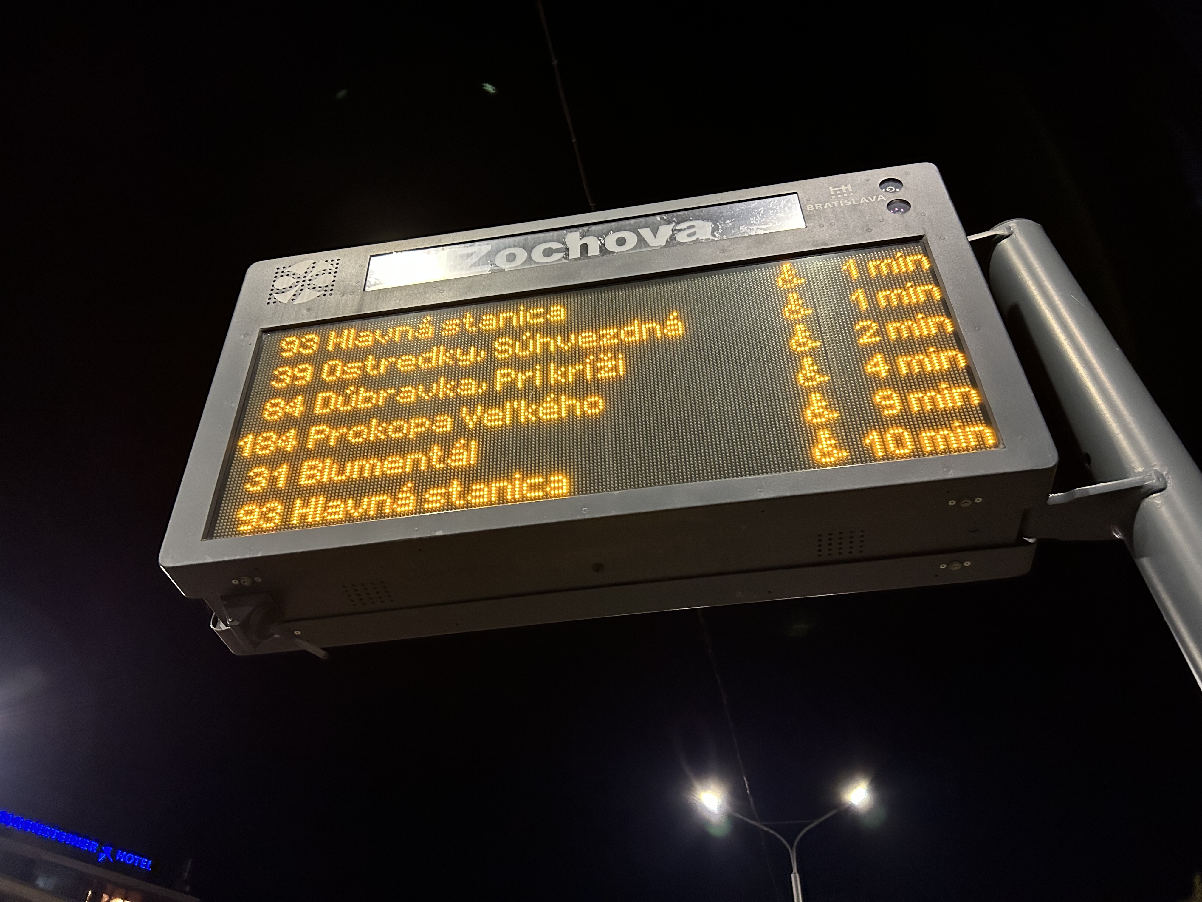
    Next vehicle display at a bus stop in Bratislava

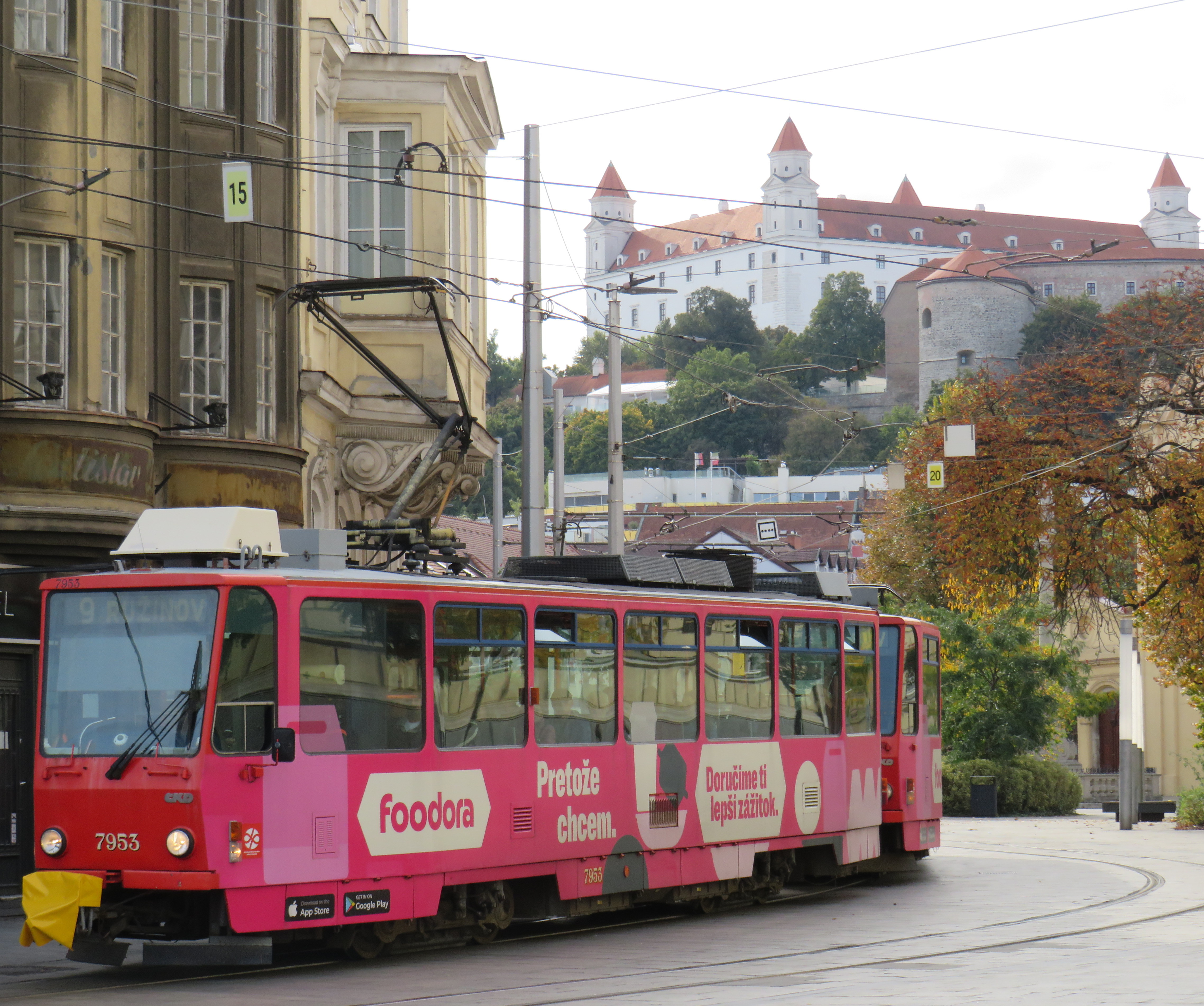
    I also noted that in Vienna, and for the most part elsewhere, vinyl advertisement wraps did not cover passenger windows on trams and buses. Bratislava’s wrapped trams had some ads that used window areas, but these were kept to a minimum.
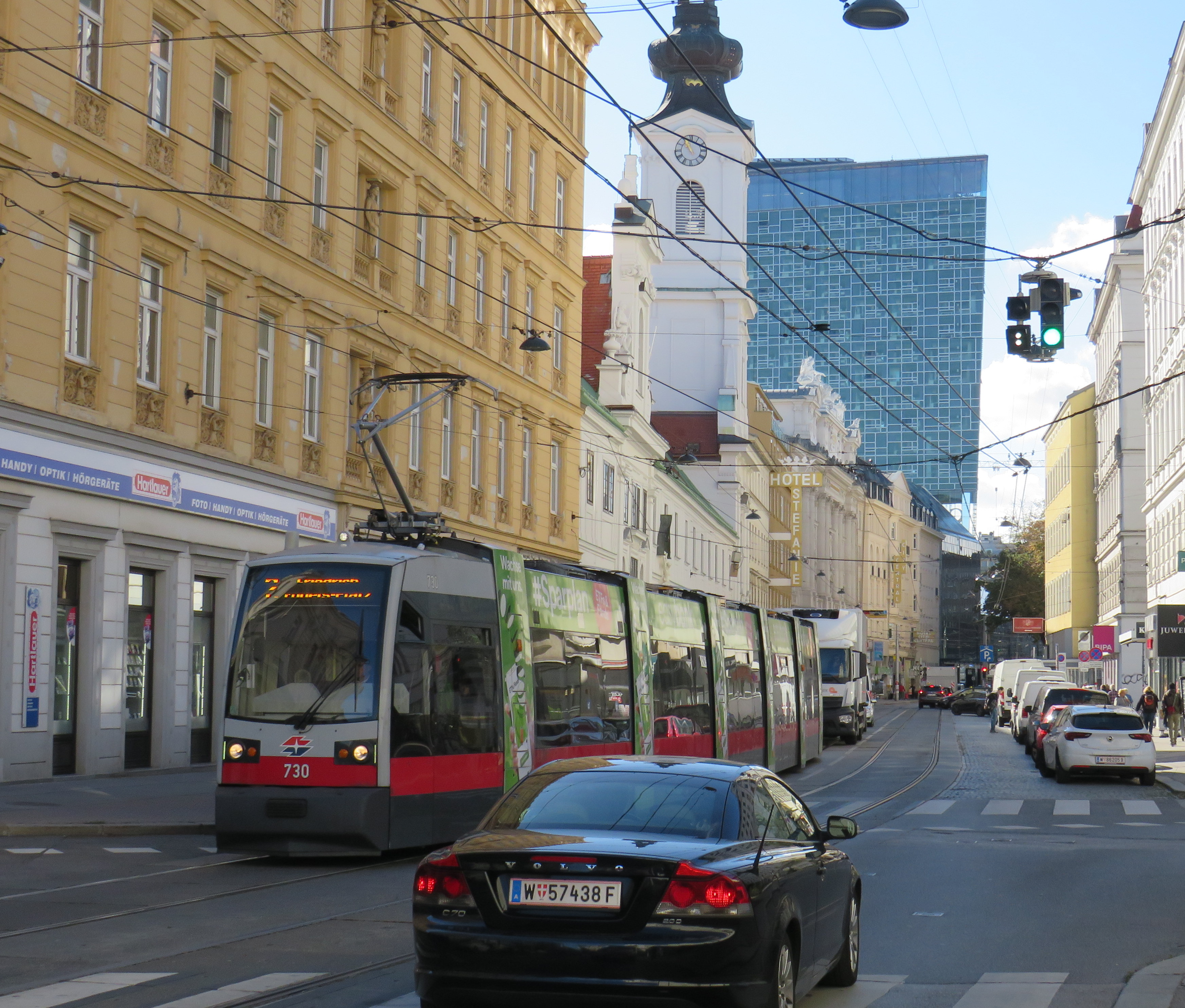
    In Vienna, advertisement wraps kept windows completely free of obstructions
    Advertisement wraps in Bratislava had minimal window coverage

    It was also clear that trams had dedicated signals on their routes, if not necessarily signal priority. But with smaller intersections and relatively short signal timings, the waits at each signalized intersection were generally minimal.
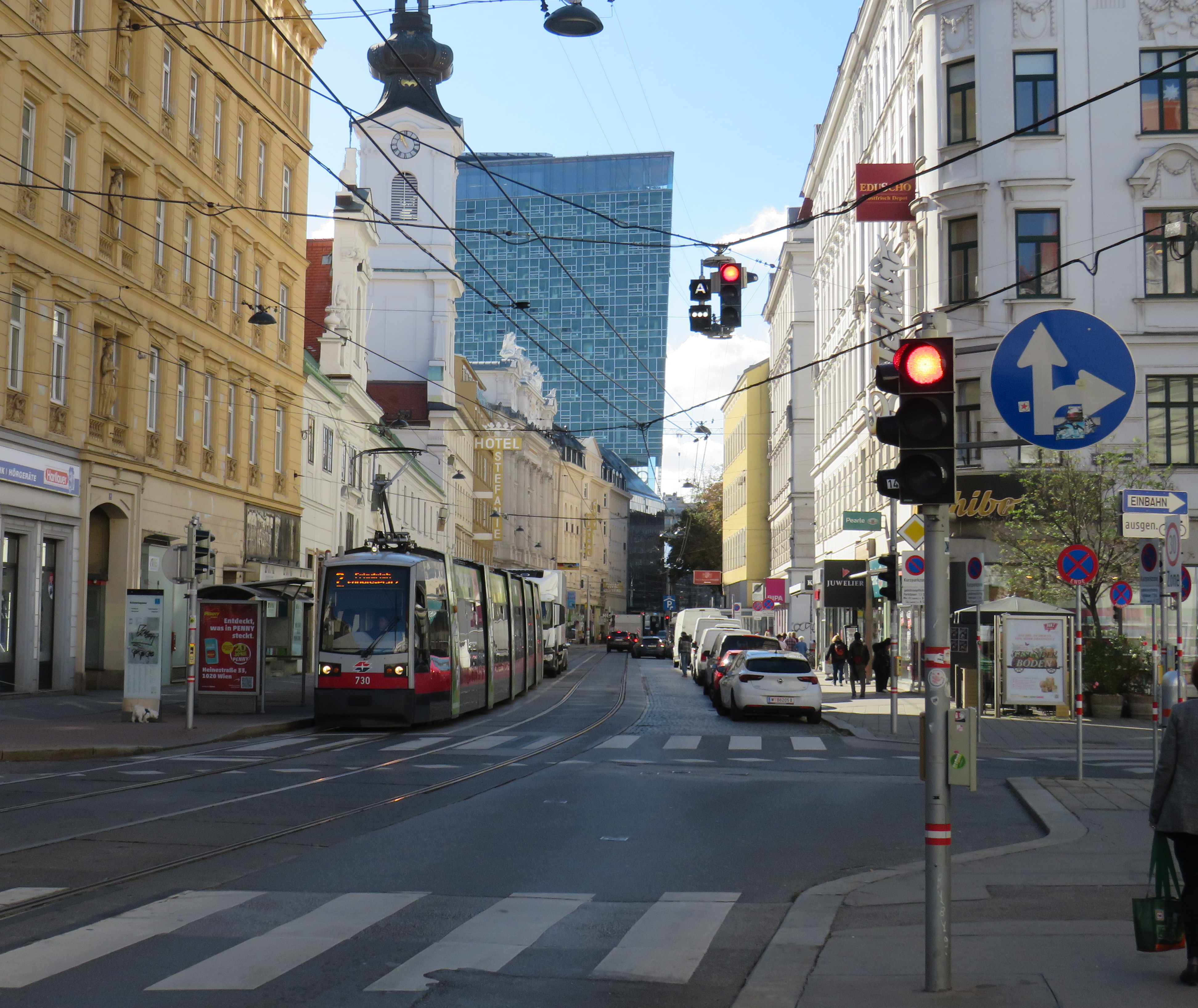
    Note the white tram signals next to the overhead traffic signal. The “A” indicates that a proceed signal will soon appear, and the operator can cancel the door release, so that no more passengers can enter or exit.

    Tram signaling in Vienna and other Central European cites also includes remotely operated electric switches. Overhead signals indicate which direction the switch is set to; operators can pass through junctions at speed. While this is how trams operate in most places around the world, in Toronto, streetcar operators are required to stop before each switch and then crawl.

    Trams pass through a track junction, along with an ambulance and a transit maintenance van. The overhead horizontal signal indicates the switch direction.

    Though many tram stops are in private rights-of-way, in-street tram stops are designed for passenger safety and accessibility. These stops, depicted by the photograph below, have the curb lane raised to the level of the low-floor trams. This increases the visibility of passengers boarding and egressing, and also simplifies ramp deployment. Operators need not exit the cab and manually deploy the accessibility ramp, a timesaver versus the TTC’s ramp deployment on major streets. In the winter, this also helps keep the slush away from the tram stops.
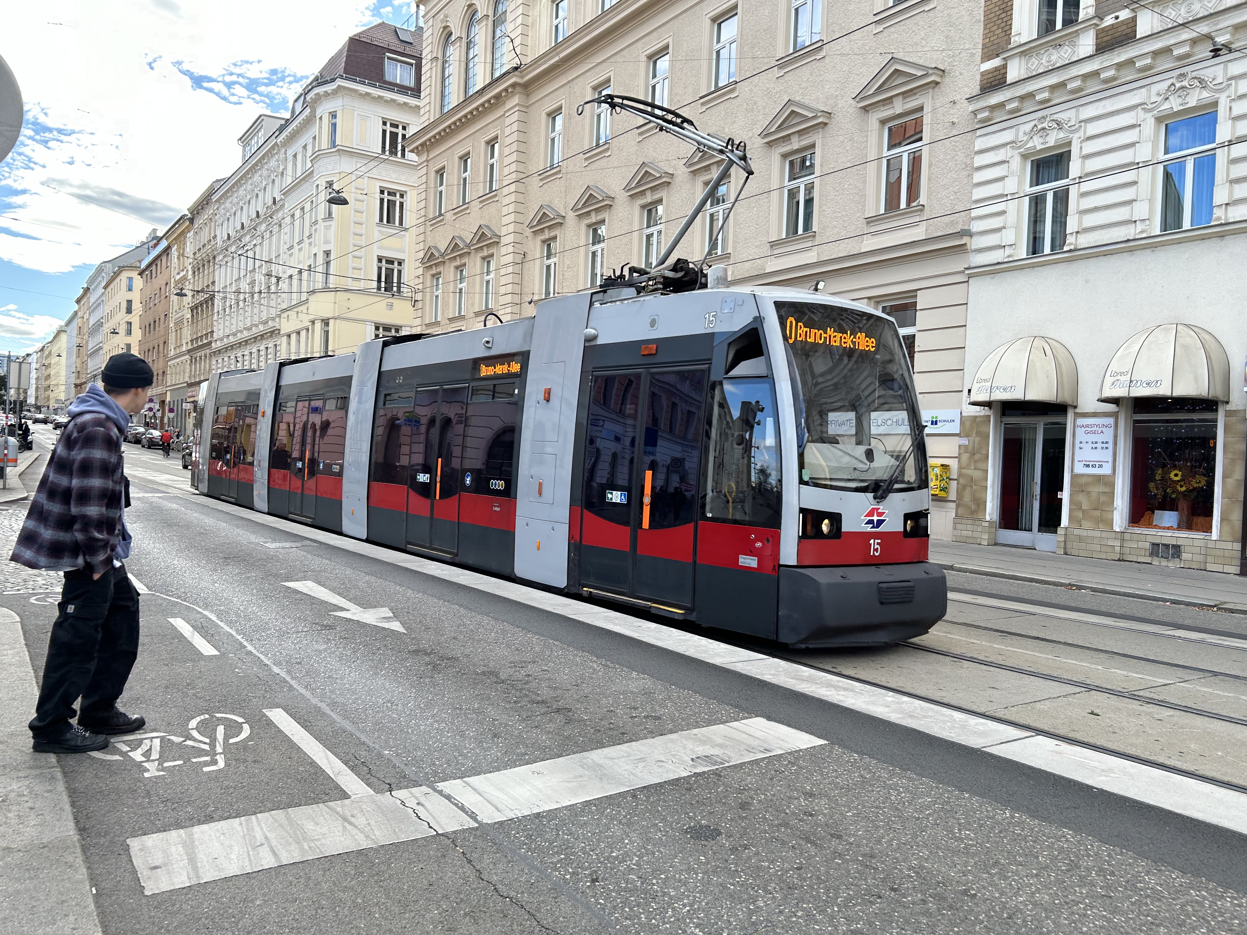
    The raised on-street curb lane at an on-street tram stop in Vienna.

    Though Toronto is a very different city than Vienna, Budapest, or Prague, there are some clear takeaways. Keep the tram windows free of advertisements. Improve communications. Fix the track switches and signalize them. Raise the curb lanes at streetcar stops for safety, convenience, and accessibility. Fix the King Street Transit Priority corridor with a permanent streetscape and tighter vehicle restrictions. If it can be done on a narrow commercial street in Bratislava’s historic centre, there’s no reason why it can’t be done in a world financial capital.

    These can even be done incrementally, but they need to be done if transit riders are deserving of respect and reliable surface transit.
  • A visit to GO Transit’s New Old Elm Station

    A visit to GO Transit’s New Old Elm Station

    The new Old Elm Station in Stouffville, Ontario

    On Monday, October 30, the new Old Elm GO Station opened in the town of Whitchurch-Stouffville, northeast of Toronto. Located two kilometres away from Stouffville’s small downtown core, Old Elm is focused on park-and-ride passengers arriving from nearby communities such as Goodwood, Uxbridge, Port Perry, Beaverton, and from within Stouffville itself.

    The new station is relatively simple, with a covered platform, a bus loop with several bays directly adjacent to the single platform, heated shelters, and a 673-spot parking lot. As a relatively quiet station with limited train service, there is no indoor waiting room or ticket office.

    The bus loop is directly adjacent to the train platform

    Though train service is limited to weekday rush hours and a few evening and weekend departures, there is regular GO Transit bus service connecting Uxbridge and Goodwood to Old Elm Station, and onwards to midday and weekend train connections at Mount Joy or continuing to Toronto Union Station. There are no York Region Transit connections at Old Elm.

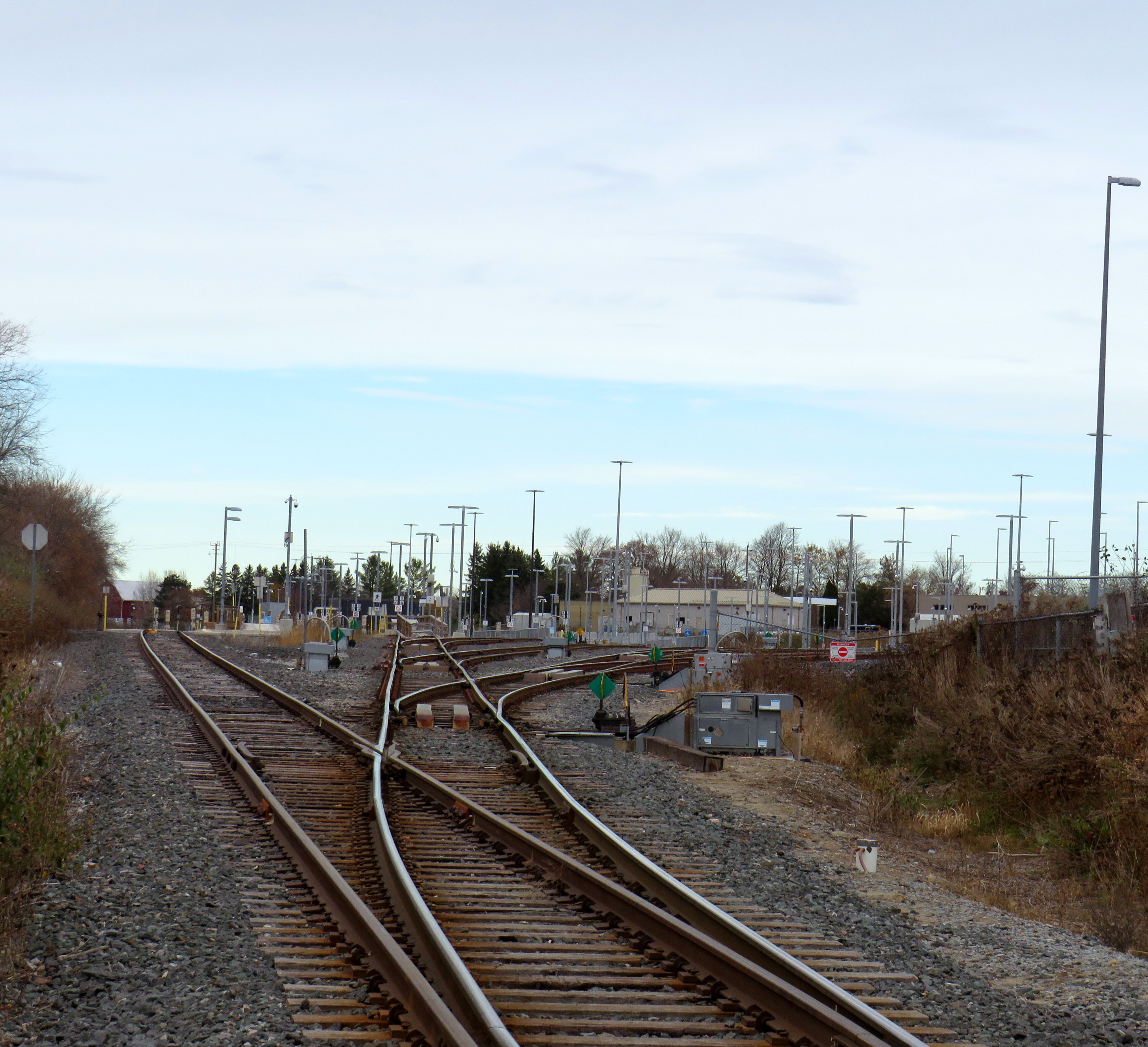
    The Lincolnville layover yard, which was also the Lincolnville/Old Elm station location until October 2023

    Previously, Old Elm Station was located a few hundred metres away, northeast of the Tenth Line/Bethesda Side Road intersection at the Lincolnville layover yard, where Stouffville Line trains continue to be stored overnight and weekends. That station, originally named Lincolnville for a nearby hamlet, was opened in 2008 to accommodate service expansion and relieve the small station at Stouffville, which had no room for a bus loop or additional parking. Since Lincolnville was a yard terminus, passengers had to walk across tracks to reach the next departing train, and each departing and arriving train had to crawl through the yard before reaching the mainline. (As Georgetown GO Station is also within a layover yard, trains passing through on their way to and from Kitchener must also crawl through. A new layover yard near Heritage Road in Brampton will allow for a rebuilt Georgetown Station with faster arrivals and departures.)

    Lincolnville Station was confusingly renamed Old Elm in 2021, even though that new name referred to a tree on the new station site that didn’t open for two more years. Had the new name taken effect with the location change, it would have made more sense.

    The new station site, located outside of the Lincolnville yard, allows for smoother and faster arrivals and departures, shaving several minutes off the trip for passengers to and from Lincolnville.

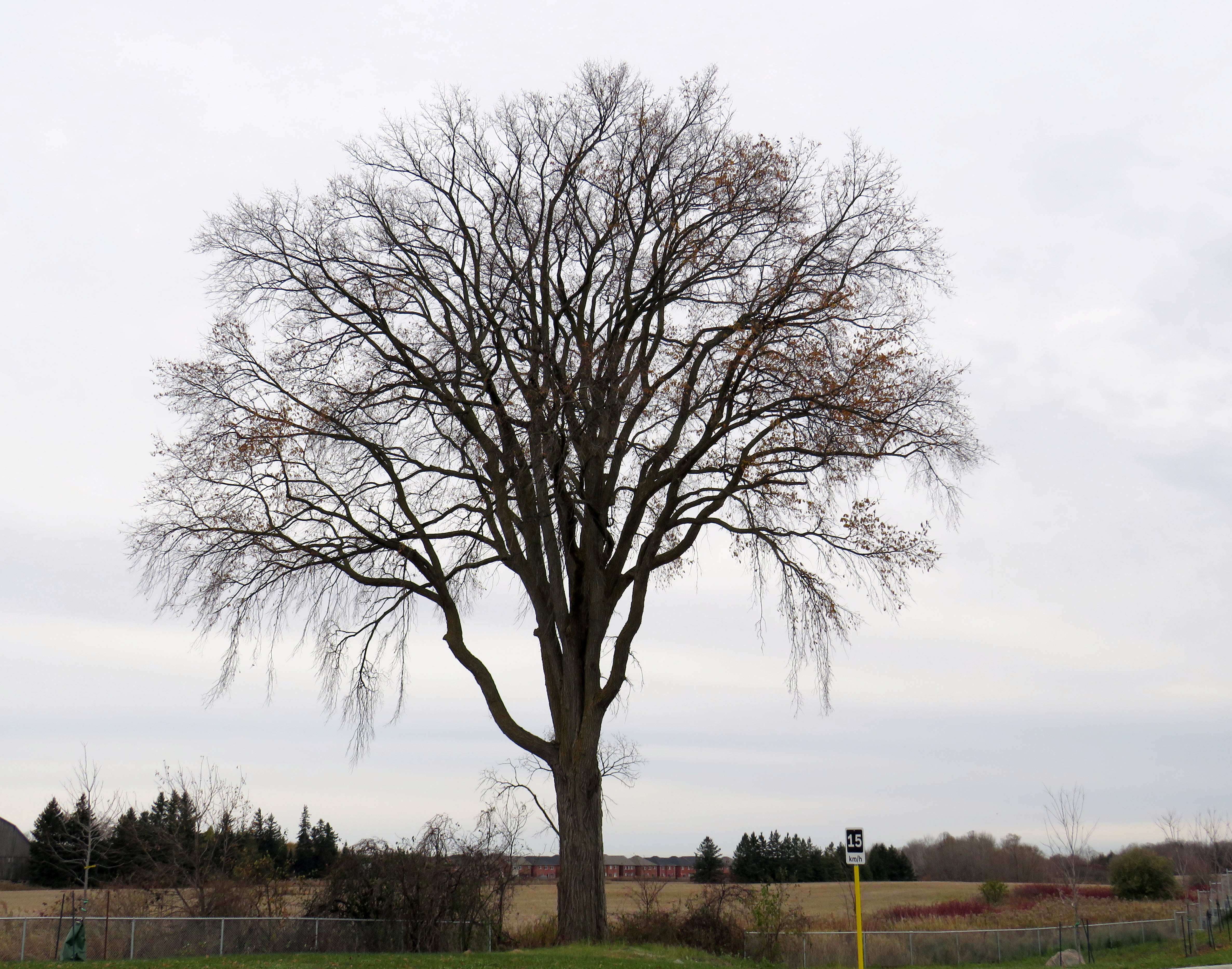
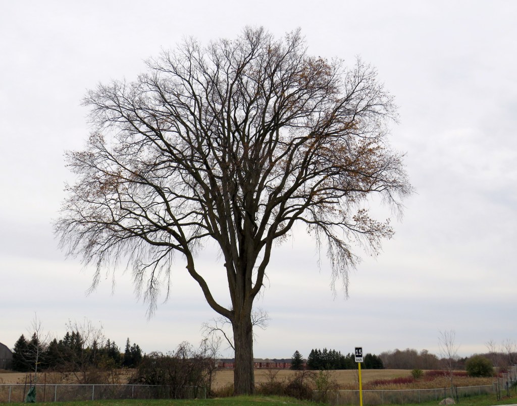
    The station’s namesake, an old elm tree on the south end of the GO Transit property

    Though Lincolnville/Old Elm is located in the Greenbelt, and the station is unable to support transit-oriented urban development, there was a need for the layover yard. Adding a small, auto-focused station was quite sensible. This is no Garage Mahal.

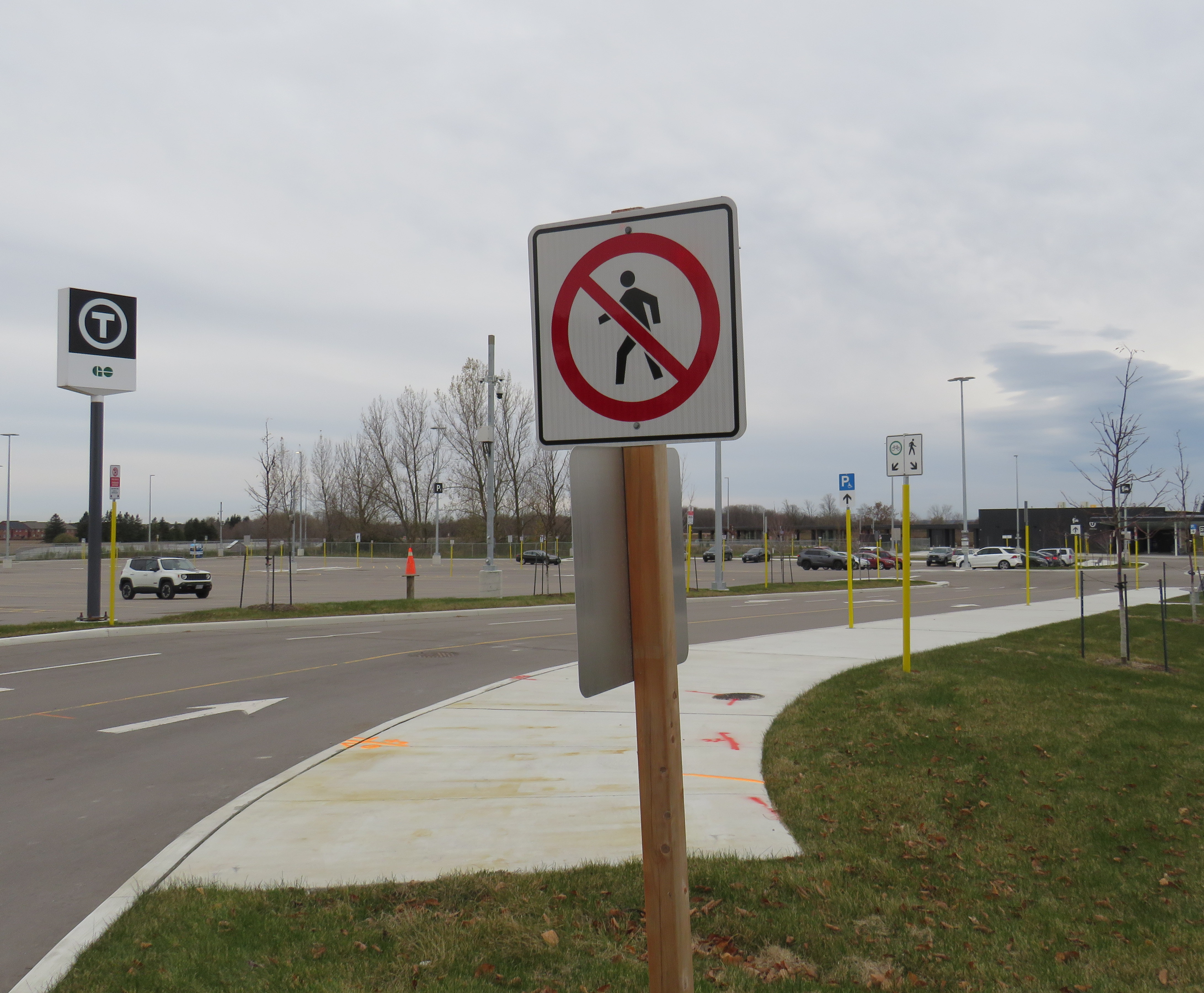
    The one unfortunate feature is the complete lack of active transportation access beyond the station property. Though Metrolinx built a wide concrete walkway from Tenth Line to the station platforms, there are no sidewalks, no crosswalks, and no pedestrian signals at either the main entrance or the bus loop entrance, which are both signalized intersections. Instead, there are “no pedestrians” signs facing all directions.

    “No pedestrians” sign placed in front of the new concrete pathway into Old Elm Station

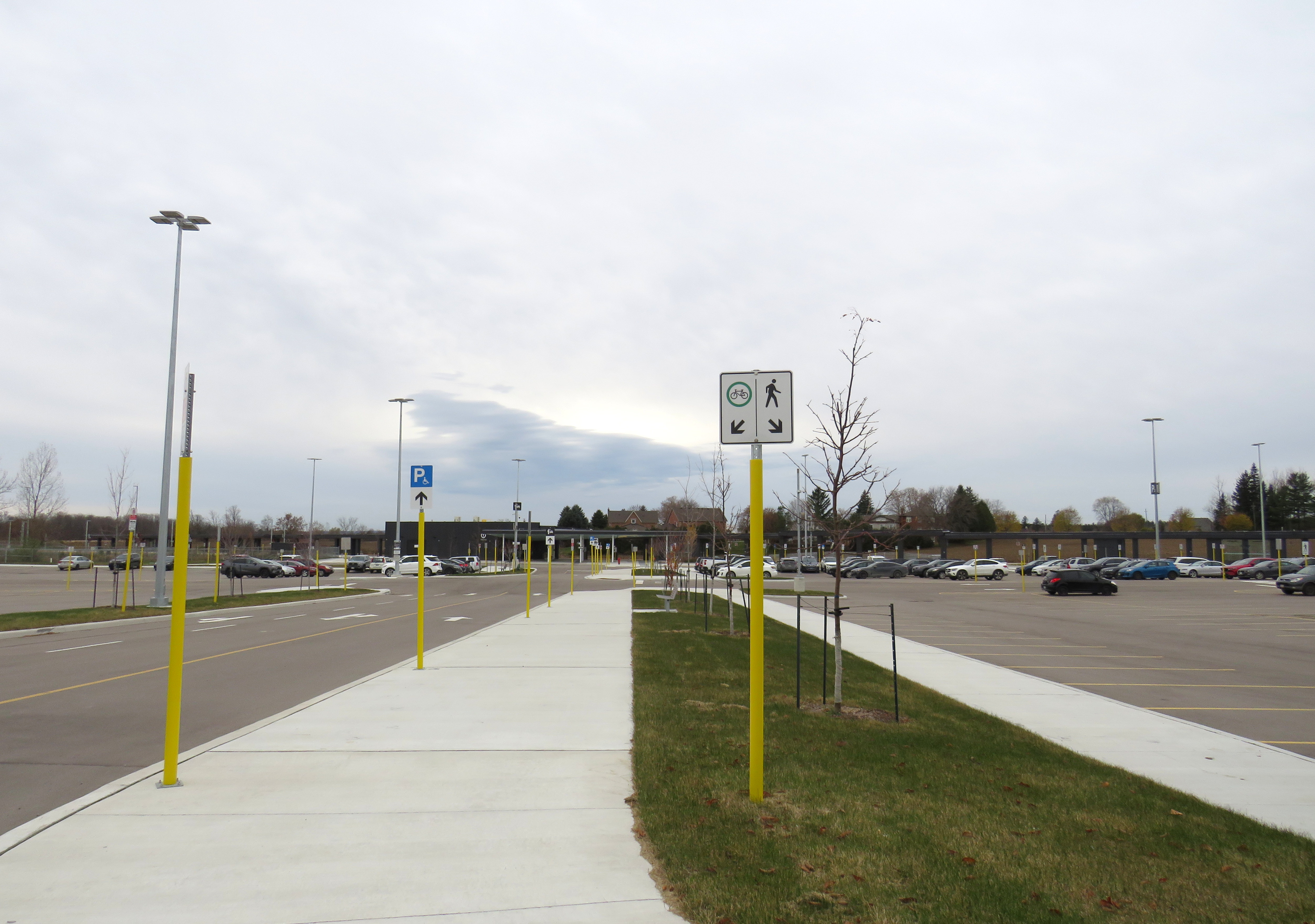
    Once on Metrolinx property, though, there is a wide pathway, presumably for cyclists and pedestrians. Interestingly, the sign below shows that cyclists should keep to the left, on the wide pathway, while pedestrians are directed into the grass to the right.

    Beyond the “no pedestrians” sign at the intersection, another sign instructs cyclists to keep to the left and pedestrians to the right – into the grass

    I doubt Metrolinx intended for the hostile intersections to forbid any pedestrian activity. I note too that despite the rural locale, there are several neighbouring homes and businesses along Tenth Line and Bethesda Side Road. The nearest subdivision is less than a 15-minute walk away, a healthy stroll’s distance. A new residential development, Elm Villa, is planned for the site immediately to the south of the bus loop. Tenth Line is maintained by the Town of Whitchurch-Stouffville, so it is likely they are responsible for the oversight. Still, it is not a great look.

    No crossing at Old Elm

  • The case against transit advertisement wraps

    The case against transit advertisement wraps

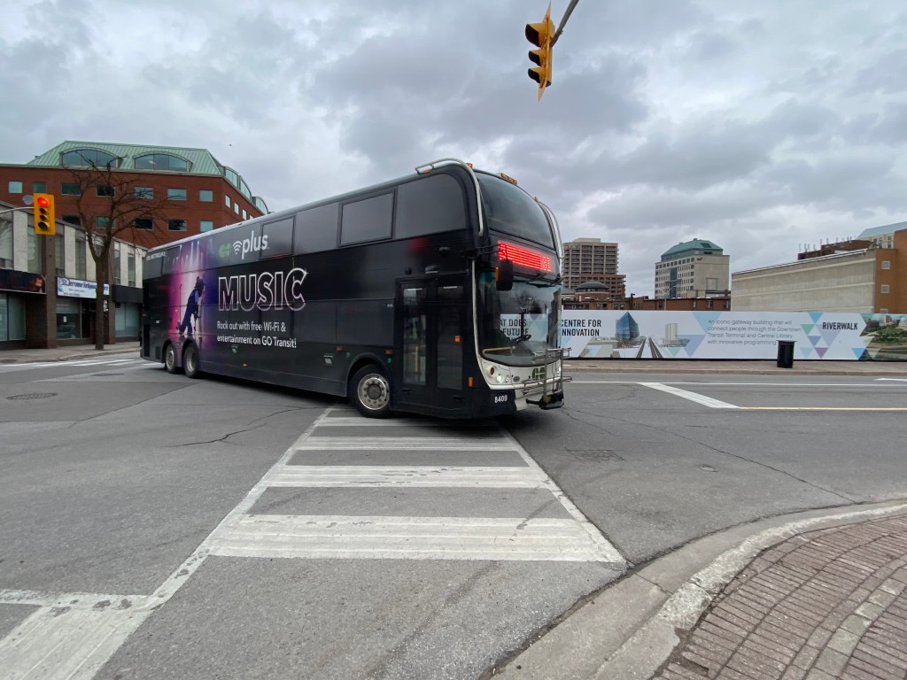
    A Go Transit double decker bus completely covered by a vinyl wrap, with the exception of the front windows and entrance door. The wrap advertises the transit agency’s wifi and music streaming gimmick.

    Apart from unscheduled short-turns, lengthy delays, or missed transfers, the thing that bothers me most about riding buses or streetcars is an obstructed view caused by a vinyl advertisement wrap.

    Though transit advertisements have been around almost as long as there have been transit services, these advertisements have generally been limited to posters and cards mounted outside the vehicles, or placed inside, above the windows or beside doors. Advertisements have long been placed inside train and subway stations, and in outdoor transit shelters.

    TTC photograph of streetcar advertising, 1935. The advertisement can be found below the left dash window of the streetcar. City of Toronto Archives Fonds 16, Series 71, Item 11134.

    For advertisers, transit ads provide an ideal vehicle for promoting their goods and services: they can be targeted to specific neighbourhoods that a bus, streetcar, or train passes through; the advertisements move around unlike static billboards, potentially drawing more eyeballs. For transit operators, advertising provides an easy revenue source. Most transit agencies outsource their advertising to larger firms, who are responsible for maintaining accounts and installing and removing ads from vehicles and transit facilities. These companies typically provide an annual payment for the right to advertise on transit vehicles, and at stations and stops.

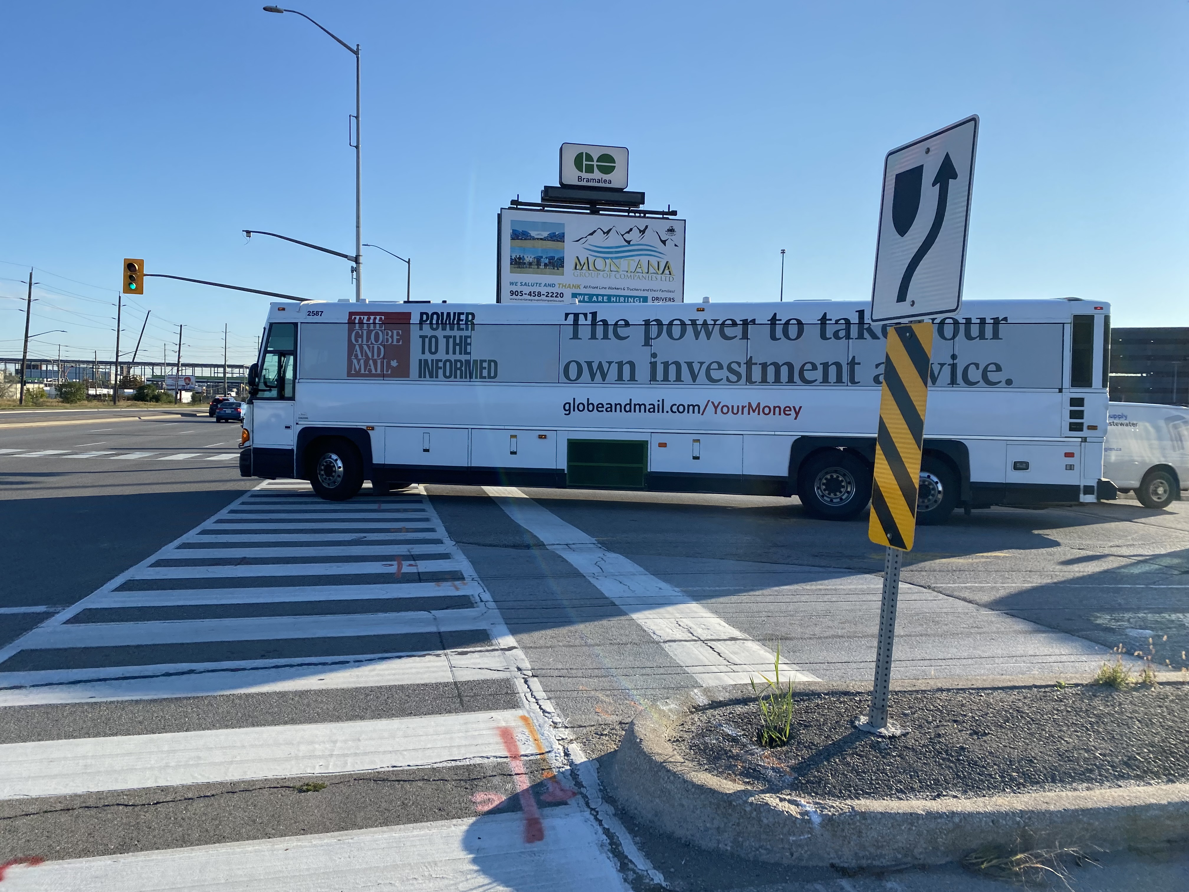
    A GO Transit coach bus departing Bramalea Station, wrapped for a newspaper’s investment news service; all passenger windows are obscured by the advertising wrap

    Though vinyl decals on transit vehicles are not a new innovation (advertisements in the late 1980s and early 1990s were typically opaque, sometimes covering parts of passenger windows) more recent technology has allowed for perforated vinyl wraps that fully cover windows, while providing an obscured outside view through small dots. While the vehicle is moving, a passenger inside may be able to see where they are, but not be able to read signage or see details. For some, not having a clear view of forward motion can contribute to motion sickness.

    The view from the inside (via Chris Livett, on X/Twitter)

    In TTC subway stations and some GO Transit stations, surfaces such as walls, floors, pillars, faregates and even stairways have also become advertising surfaces, a tactic called “station domination.”

    An example of Pattison Outdoor’s “station domination” advertising, with a traditional ad poster at right, an installed video screen and ad pillar at centre, and stairs covered in ads, at left.

    On occasion, vehicle wraps are used for public relations, rather than advertising. GO Transit and the TTC’s Pride buses are a good example of this. A more shameful example was the TTC’s messaging about fare evasion which took place in late 2019 and early 2020, just before the COVID-19 pandemic.

    “Forgot to tap” – part of a TTC streetcar wrap used in late 2019 and early 2020

    For the most part, the TTC does not allow ad wraps to completely obscure bus and streetcar windows, but allows up to 70 percent of the passenger windows to be covered, either in a “strip” format (where only the lower parts of the windows are kept uncovered) or “mural” format (where three of five sections of a streetcar are fully covered). Other agencies, like the Hamilton Street Railway, allow for complete vehicle wraps.

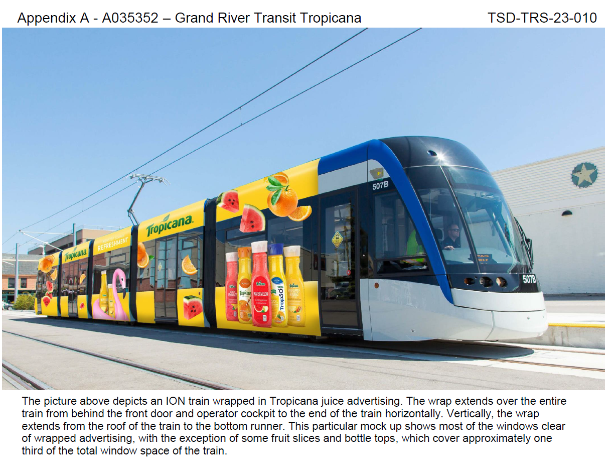
    In Waterloo Region, Regional Councillors just considered a motion to increase the number of wrapped Grand River Transit buses and — for the first time — on ION LRT cars. The appendix to the staff report recommending the increased number of advertising wraps depicts a rail car in a Tropicana wrap, with the windows partially obscured.

    Depiction of what an advertising wrap would look like on an ION LRT rail car, from the October 10 agenda of the Regional Municipality of Waterloo Planning and Works Committee

    According to the report, the Region of Waterloo/Grand River Transit has a contract with Pattison Outdoor — one of Canada’s largest advertising firms — that allows for a total of five buses to be wrapped at any one time. GRT and Pattison want to increase this to ten percent of the total bus fleet, which numbers over 250. It also seeks to wrap one ION rail car at a time, with the promise that windows would not be fully covered and convert some static back-lit shelter ads to digital ads.

    Currently, Waterloo Region receives guaranteed revenue from its contract with Pattison, averaging $1,546,500 a year, though the total revenue is projected to reach $1,800,000 for 2023, as ridership increases. Allowing for wraps on 20 more buses and one ION railcar is estimated to net an additional amount up to $500,000.

    It’s worth noting that the report notes a 2018 recommendation against advertising on the exterior of LRT vehicles “due to concerns of diminishing the ION brand.” This restriction was also carried to ION-branded buses that follow the planned LRT extension between Fairway Station and Cambridge. It also notes strong public feedback against covering windows, and proposes to do so, “to maintain the customer experience.”

    The Region of Waterloo’s entire Transit Services budget — including paratransit — for 2023 is $207,203,000, with transit fares bringing $46,143,000 of that – a 22.3% farebox ratio (property tax and provincial grants cover the difference). $2.3 million brought in from all advertising revenue — traditional poster ads and transit wraps — is not an insignificant sum, but it makes up just over 1% of the entire transit operating budget. In Toronto, the TTC’s 12-year, $324-million contract — also with Pattison Outdoor — brings in a total of $27 million a year, or 1.1% of the entire TTC budget.

    At least Waterloo Region staff recognize that transit customers don’t like advertisements that obscure windows. They also acknowledge that transit wraps diminish the transit brand. For a revenue source that represents a mere drop in the bucket, why do transit agencies keep allowing them on their vehicles?

  • An innovation in station naming rights?

    An innovation in station naming rights?

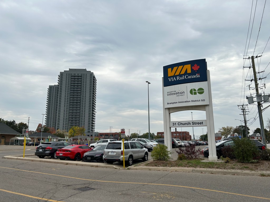
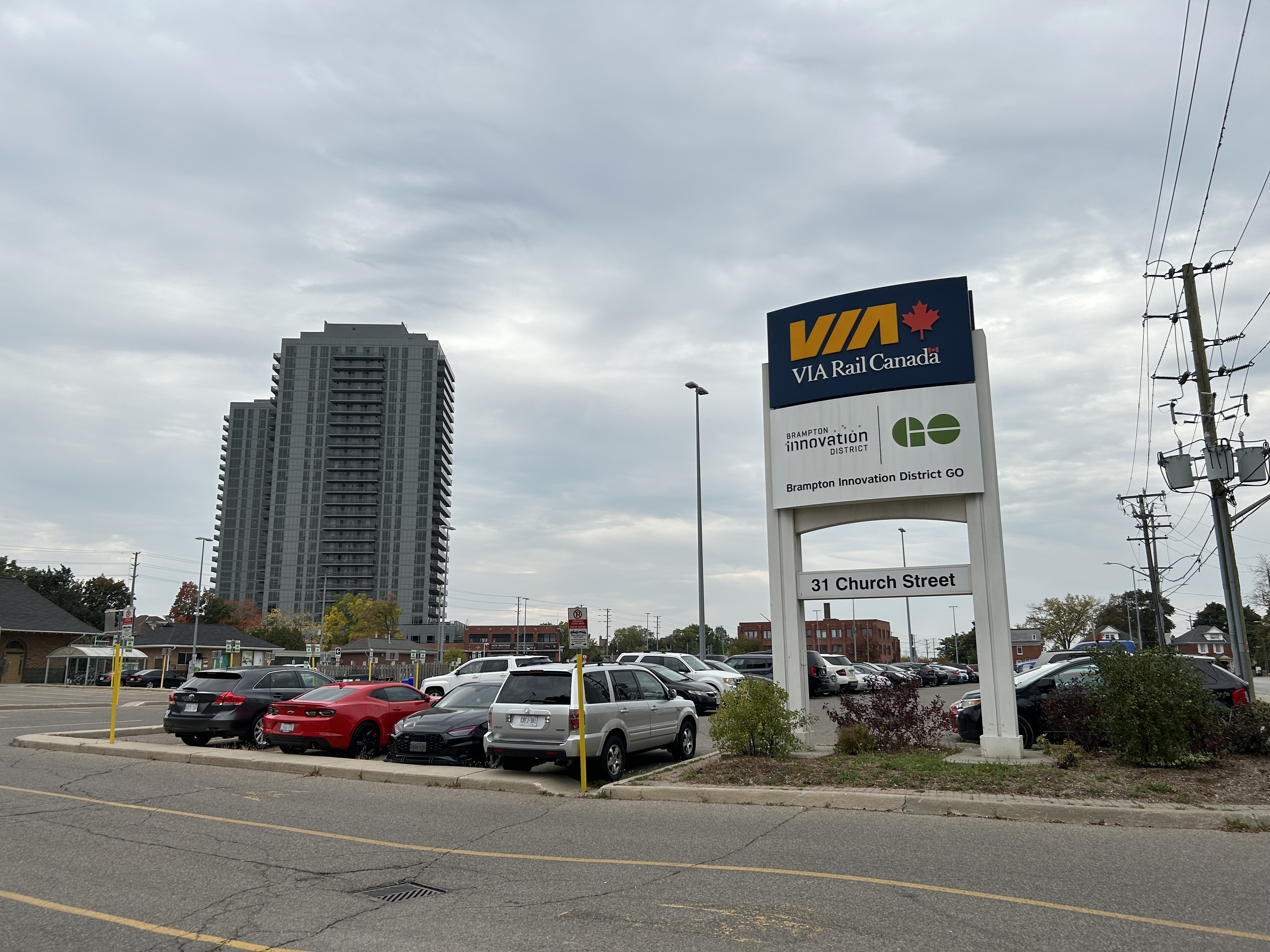
    Brampton Innovation District GO sign

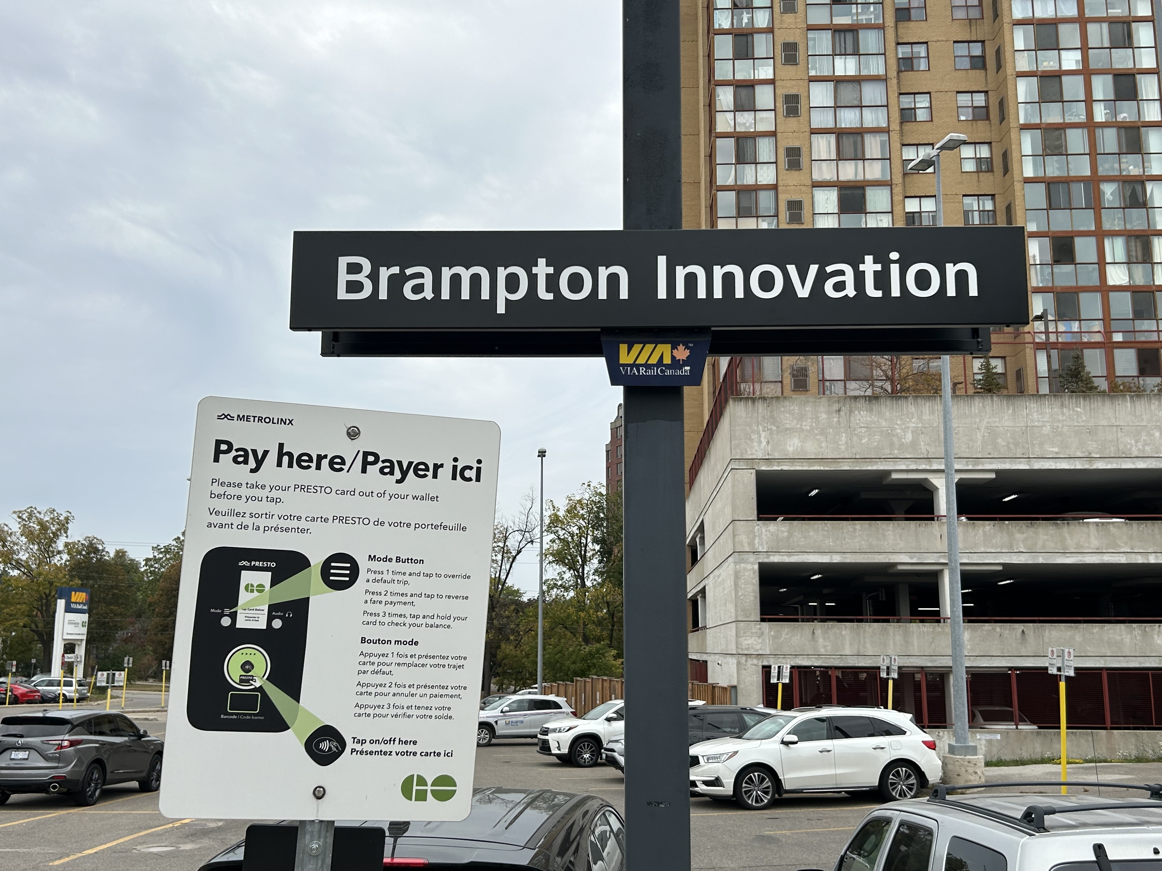
    On June 29, 2023, the City of Brampton announced a naming rights agreement with Metrolinx to rename the Brampton GO Station to “Brampton Innovation District GO” for a 10-year period. This was Metrolinx’s second naming rights agreement, after renaming Oshawa GO Station for Durham College in 2022. The name change took effect in September, with new signs installed.

    The Brampton Innovation District is a city-led project in Downtown Brampton to support higher education and entrepreneurship. It includes co-working spaces such as BHive and the Brampton Enterprise Centre incubator, the Rogers Cybersecure Catalyst, as well as partnerships with Sheridan College, Toronto Metropolitan University, and Algoma University. Rogers has committed to relocating its Brampton offices to the downtown core, while the city is planning the Brampton Centre for Innovation, which will include a new central library. There are a lot of interesting things happening in Downtown Brampton, though without the exposure more established tech hubs enjoy.

    In this context, the deal to rename Brampton GO Station makes some sense. As the June 29, 2023 press release from the City of Brampton says:

    Through increased awareness of the Brampton Innovation District, this partnership with Metrolinx will further enhance Brampton’s position as an innovation and technology event destination to host tech sector events and international delegations, and enhance Brampton’s unique ability to attract highly skilled tech talent from both Toronto and Waterloo.

    Unlike “Durham College Oshawa GO,” at least “Brampton Innovation District GO” is at the place it is named for. Having the name show up on maps, signage, and announced by GO Transit staff will raise awareness of the district’s current and future potential, especially once some of the built infrastructure, such as the Centre for Innovation, the new downtown transit hub, and the new Rogers campus, is constructed.

    The “GO Brampton” sign has been replaced by “Brampton Innovation”

    But at the same time, I still feel uneasy about renaming stations and transit lines. The new, longer names are harder to fit on maps and signage. They can lead to confusion, and in this case speak more to the city’s ambitions than what most travelers are actually looking for. It’s also interesting that the only two naming rights deals made by Metrolinx so far are with public-sector organizations: a provincially funded college, and a municipality.

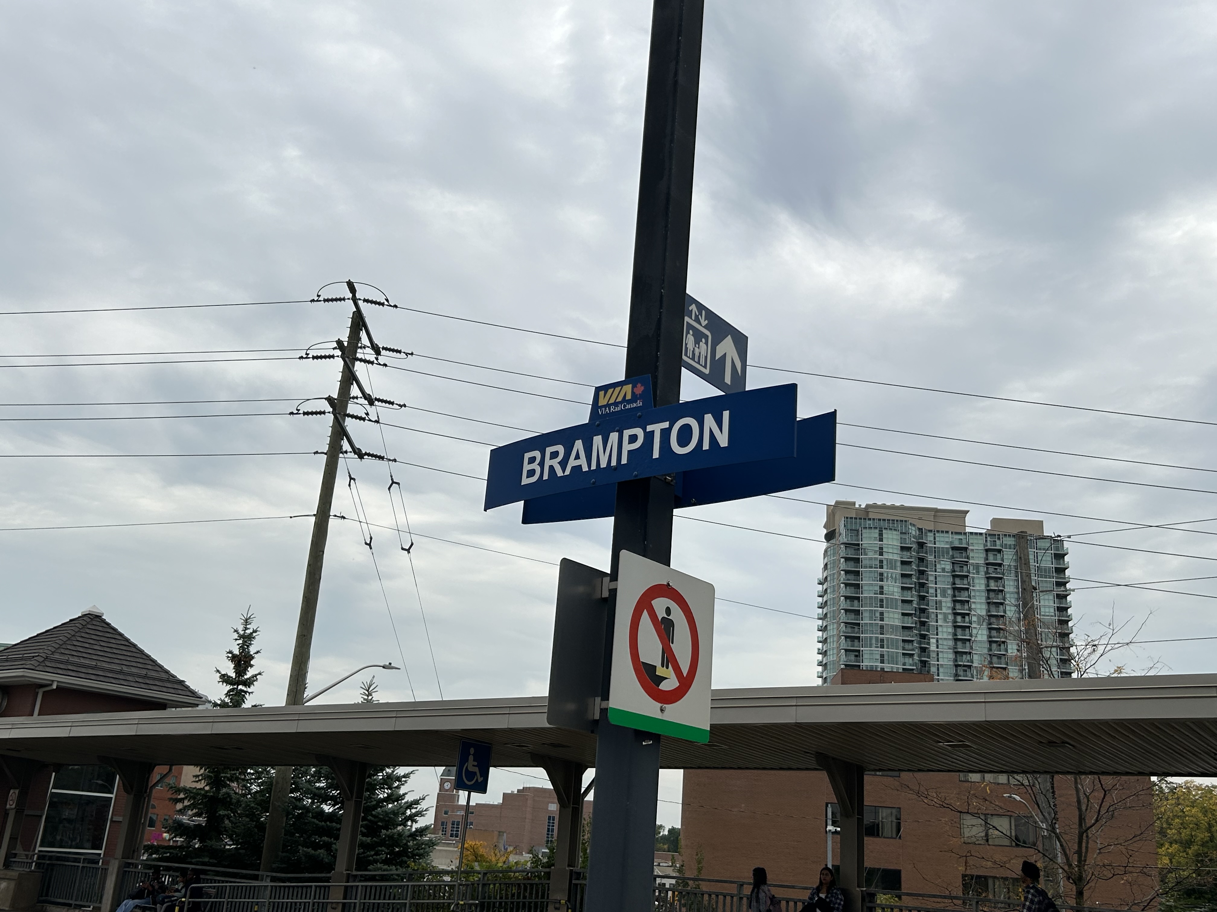
    I also note that VIA Rail, which also uses the station, still refers to it simply as “Brampton,” just as it still simply refers to “Oshawa.”

    VIA Rail still just calls it “Brampton.”
  • The slow way to Peterborough

    The slow way to Peterborough

    A busy GO Transit Route 88C bus loads passengers in front of the Peterborough Bus Terminal in the city’s downtown core

    Peterborough, Ontario, a city of 84,000 people, is about a 90-minute drive from Downtown Toronto, without heavy traffic. A regional centre for central-east Ontario, Peterborough is home to Trent University, a mid-sized liberal arts institution with about 10,000 full time students, and Fleming College, which has over 6,000 full time students and 10,000 part time students.

    Given its relative importance and its proximity to the Greater Toronto Area, especially Durham Region, one might expect to find good transit links from Peterborough to not only Toronto, but elsewhere in Ontario. Unfortunately, this is not really the case.

    Prior to the COVID-19 pandemic and the closure of Greyhound Canada’s remaining service in Ontario and Quebec, there were four daily Greyhound buses between Peterborough and Toronto (three on Saturdays and Sundays), with one of those daily runs continuing east on Highway 7 to Ottawa, with stops in towns such as Havelock, Madoc, and Perth.

    The scheduled time between the old Toronto Coach Terminal at Bay and Dundas Streets and Downtown Peterborough was between one hour and 45 minutes (making only an intermediate stop at Scarborough Centre Station) and two hours, 15 minutes (making local stops in Ajax, Oshawa, and Orono).

    2019 Greyhound timetable for Ottawa-Peterborough-Toronto service. Note the overnight 5757/5790 runs that also followed Highway 7, but only stopped at Madoc for a rest break.

    In September 2009, GO Transit first started a bus service between Oshawa GO Station, Downtown Peterborough, and Trent University, following the success of other bus services to universities and colleges in the region. Before 2020, that route made only four stops between Oshawa Station and Downtown Peterborough; all were park-and-ride lots adjacent to Highway 35/115; the bus would take just over an hour between the station and Downtown Oshawa.

    Despite GO Transit’s competition, the Greyhound service remained popular, as it offered a direct, faster, one-seat ride between Downtown Toronto and Downtown Peterborough, with most buses only stopping at Scarborough Town Centre along the way. Three days a week, there were connections to Bancroft and Pembroke. GO Transit’s advantage was a slightly cheaper fare, connections to local transit and other GO services, and a more convenient service for passengers travelling between Durham Region and Peterborough. Unlike Greyhound, GO Transit continued to Trent University. Apart from the Newcastle (Hwy 2 at Hwy 35/115) park-and-ride, where passengers could connect to GO Transit routes 90/91 to Newcastle, Bowmanville, Courtice, and Downtown Oshawa, the park-and-ride stops were little-used.

    GO Transit Route 88 map, January 2020. There were only four stops between Oshawa GO Station and Peterborough Bus Terminal

    In mid-2020, with the COVID-19 pandemic causing major reductions in bus and rail ridership, GO Transit cut and consolidated several services, particularly in areas where local transit agencies operate. Route 90 was reduced to early morning and late-night service between Union Station and Oshawa GO when trains were not operating. The remainder of Route 90 through Courtice, Bowmanville, and Newcastle was cut entirely. Route 91 was merged into Route 88, which added new stops in Courtice and Bowmanville.

    Route 88B, which includes stops at park-and-ride lots at proposed new GO Stations in central Oshawa and Courtice, takes up to 120 minutes to get from Trent University to Oshawa Station. The regular 88 bus takes 105 to 115 minutes to complete the trip. That is a very long time to sit on a bus, especially one not equipped with a lavatory.

    GO Transit’s Route 88 bus timetable, including connecting train service from Toronto Union Station (click for larger size)

    On Thursdays and Fridays, during regular school days between September and April, there are several express 88C buses, that only stop at Trent University, Peterborough Bus Terminal, and Oshawa GO. They make the complete trip in 1 hour 20 minutes; from Union Station to Downtown Peterborough is 2 hours, 20 minutes, not much slower than the slowest Greyhound bus.

    The Route 88 route map in September 2023

    Granted, for anyone living in Bowmanville and headed to Peterborough, the route is an improvement, with a new one-seat-ride now possible. While travelling to Peterborough earlier in September, I noted several passengers getting on in Downtown Bowmanville. But for through passengers, the backtrack to get to the Clarington Boulevard Park & Ride (the proposed location for the Bowmanville GO Station) and then the local stops to Newcastle are a bit annoying. Once on the highway, the bus has to get off at the Highway 35/115 split near Pontypool, and again at County Road 10 near Cavan and Millbrook, despite the very occasional time a passenger wants to get on or off (which has never happened when I rode Route 88). These diversions add 2-3 minutes each to the trip.

    Pulling up to a deserted GO bus stop at County Road 10 near Cavan

    These carpool stops might be useful if there were connecting transit services, rather than just a parking lot and a bus shelter. The 35/115 lot near Pontypool is 34 kilometres to Lindsay, a town of nearly 20,000 people, but whose only transit connection is a 3 day/week TOK coach bus between Haliburton and Toronto. A shuttle connection to Lindsay (which has a local transit service) would provide new links to Toronto, Durham Region, and Peterborough. Meanwhile, the Highway 2 carpool lot does not have direct Durham Region Transit service either.

    Since Greyhound Canada’s withdrawal from the Canadian market, GO was the only intercity operator serving Peterborough until earlier this year, when Rider Express and Flixbus resumed service on the Toronto-Peterborough-Ottawa route. Both companies offer express, one-seat rides to downtown Toronto, but they have two major disadvantages over GO or even the old Greyhound service: frequency and in-town connections.

    Flixbus offers one daily round trip, leaving the Union Station Bus Terminal at 11:00 AM and arriving at a Tim Hortons parking lot (at 1200 Lansdowne Street West, on the southwest side of Peterborough), at 1:05 PM, with stops near Scarborough Town Centre and at Thickson Road and Highway 401 in Whitby. The return trip leaves Peterborough at 9:05 PM, arriving in Toronto at 11:05 PM.

    Boarding a Flixbus coach in a parking lot behind a Tim Horton’s in Peterborough’s suburbs

    Rider Express runs on the same route four days a week, leaving Union Station at 12:00 PM, arriving at a different Tim Horton’s parking lot (on Ashburnham Road, on the southeast side of Peterborough) at 1:45 PM, making one stop in Scarborough. The return trip leaves Peterborough at 10:05 PM and arrives in Toronto at 11:35 PM. The map below shows where GO, Flixbus, and Rider Express stop in Peterborough.

    While GO stops at Trent University, Downtown Peterborough, and a park-and-ride lot on the south end of the city, Flixbus and Rider Express only stop at locations close to the main highway on the south side of Peterborough, pulling into parking lots with nowhere to sit and no real amenities, unless waiting passengers had a car to wait in or paid for a coffee or snack at the Tim Horton’s. The old Greyhound terminal, which was located on the same block as the downtown transit terminal, has since been sold, and is now converted for local community services. Though they offer a much faster ride to downtown Toronto, the private operators are neither frequent enough nor convenient enough to compete with GO.

    One day, Peterborough may get intercity rail service again thanks to the federal High Frequency Rail project, still in the early procurement phase, which would provide the speedy, frequent intercity service Peterborough needs. Until then, Metrolinx should revise the entire Peterborough bus service, including working with Durham Region and the City of Kawartha Lakes to make the service more useful for more riders, with a mix of daily express buses and enhanced local connections. The Selwyn Link bus service, which connects GO and Peterborough Transit with Selwyn Township and Curve Lake First Nation at Trent University, is great example to build upon.


    I have updated the Ontario Intercity Transport Map for September 2023 with new and revised routes right across the province. The notable losses include Prescott-Russell’s abandonment of its rural on-demand service, the closure of Grey Transit Route’s service between Walkerton and Flesherton, and Trailways’ stop in Chatham. The London-to-St. Thomas gap remains unfilled, and there’s a clear gap in Huron and Bruce Counties, especially with the loss of service to Walkerton. For the most part, it is good to see most regional transit services continuing, with mostly minor adjustments.

    I look forward to sharing my Canada Intercity Transit Map, based on work I recently completed for Infrastructure Canada, in the near future.

    Link to intercity map
  • Line 3: struck from the maps

    Line 3: struck from the maps

    2018 view of the Scarborough RT, looking north towards Ellesmere Station

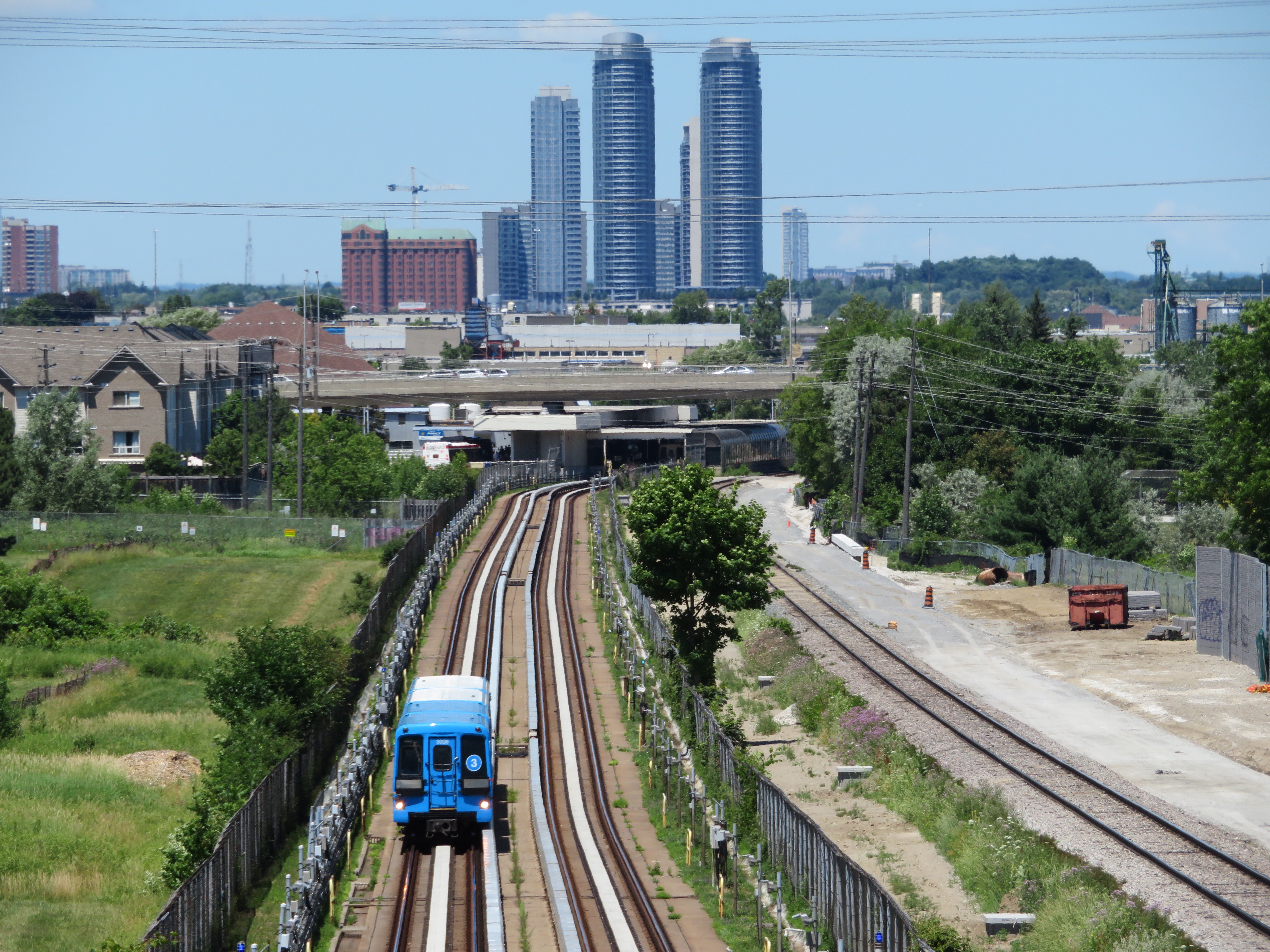
    On Monday July 24, at 6:45 AM, a Scarborough RT car on Line 3 derailed soon after departing Ellesmere Station. Forty-five passengers were on board, and five suffered minor injuries. The Scarborough RT, which opened in March 1985, was suspended, and then permanently closed, four months ahead of its planned shutdown on November 18, 2023. For the first time in its history, Toronto’s rapid transit map has shrunk.

    (more…)
  • Automatic for the people: Riding Montreal’s new REM

    Automatic for the people: Riding Montreal’s new REM

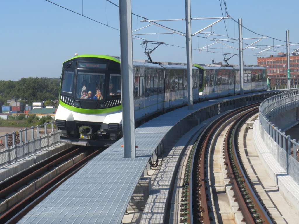
    North America’s newest rapid transit service, the Réseau express métropolitain (REM), opened on Monday, July 31, 2023 after a weekend of free public rides. I took my first ride several weeks later, on August 22, 2023. The five stop, 16.6-kilometre line between Central Station and Autoroute 30 in Brossard, is the first of four phases of the initial REM network, with branches north and west of Downtown Montreal to open in the next few years.

    Built by the CDPQ Infra, a division of Caisse de dépôt et placement du Québec (a provincial public pension fund), REM is a light metro network connecting suburban communities with Montreal’s urban core. With limited stops, a downtown-suburban focus, and frequent service, REM has similarities to Bay Area Rapid Transit (BART) in the San Francisco metro region, to S-Bahn systems in Germany and Austria, or RER in metropolitan Paris. Like Vancouver’s SkyTrain or the future Ontario Line here in Toronto, the trains are short, and operate fully automatically, running every 3.5 minutes during weekday peak periods, and every 7.5 minutes at all other times, from 5:30 AM until after midnight.

    As REM is being built by a pension fund — which seeks to make an 8% return on building and operating the service — financing the line is a bit different. Though it received financing from the Canada Infrastructure Bank and support from the provincial government, much of the funding comes from other sources, such as development levees. It is also guaranteed a share of fare revenue from the provincial government.

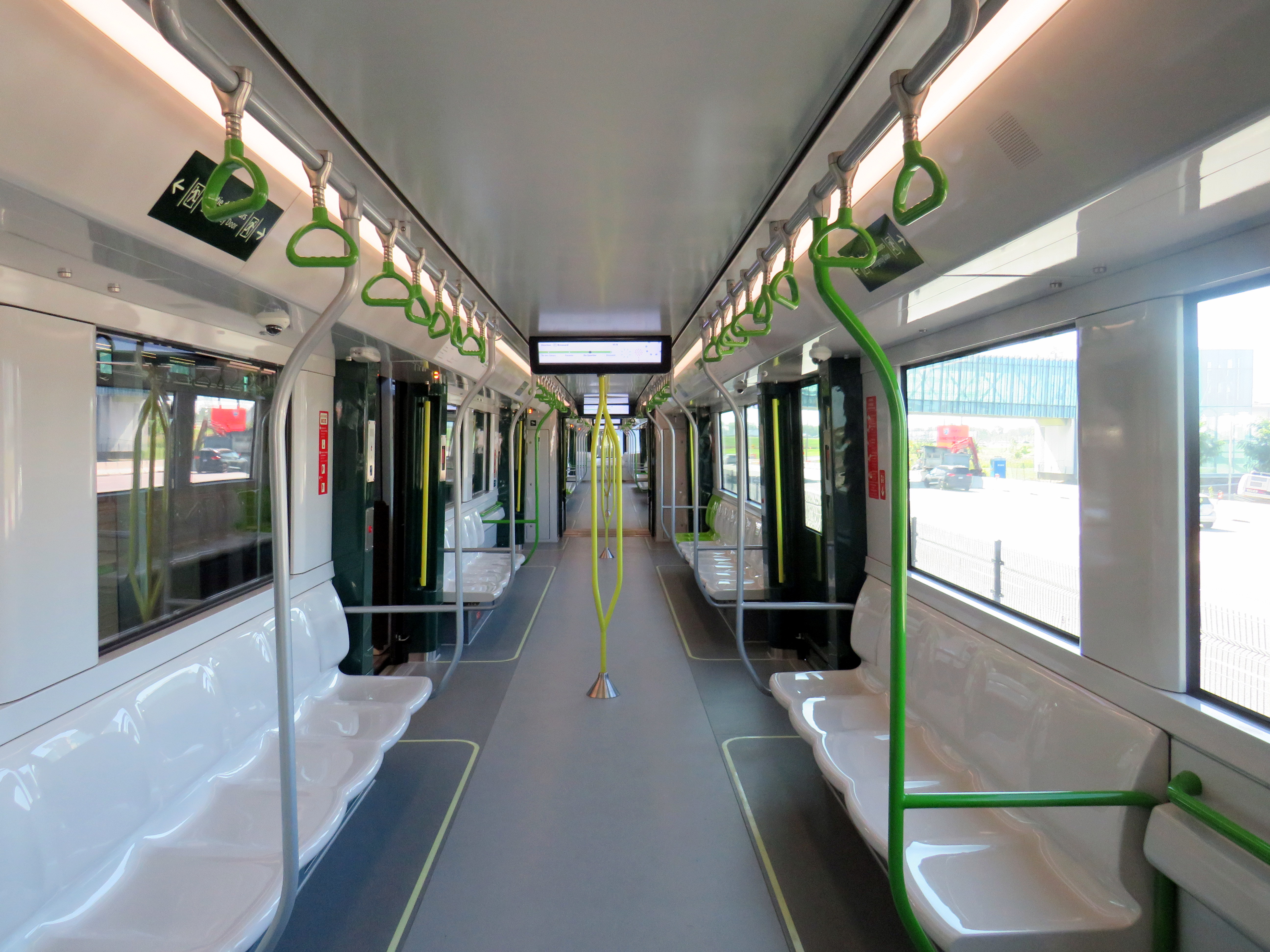
    Rail car interior. All seats face inwards, there are 64 seats per car, with standing room for up to 300.

    Though several notable transport enthusiasts have already documented the new REM during its opening weekend, I wanted to wait for some of the excitement to wane; I also wanted to experience the service from a regular passenger’s point of view, including checking out the stations and transfers to other transit operators.

    For the most part, I came away satisfied. However, I encountered several shortcomings, particularly with service integration and transfers between modes.

    (more…)
  • Toronto’s saddest subway stop

    Toronto’s saddest subway stop

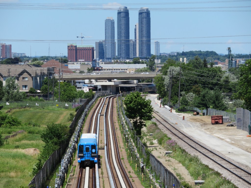
    Islington Station, opened in 1968 as part of a major expansion of the Toronto subway system into Etobicoke and Scarborough, is now literally falling apart.

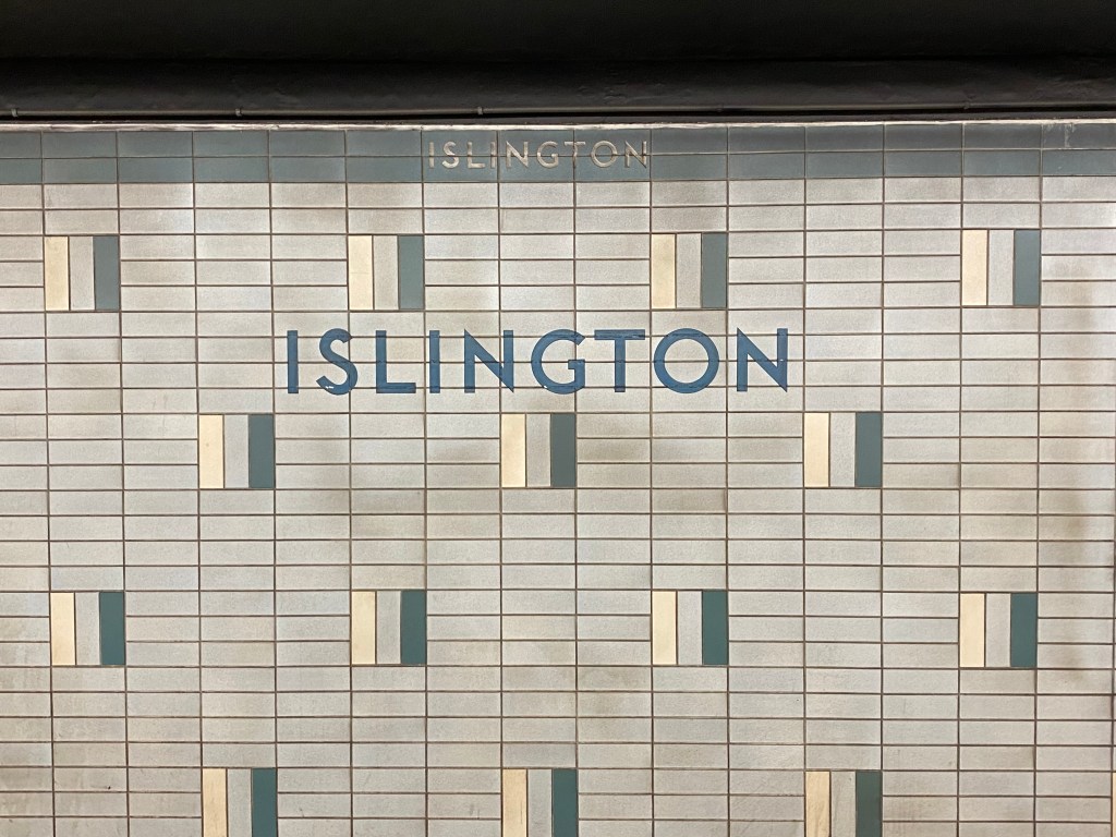
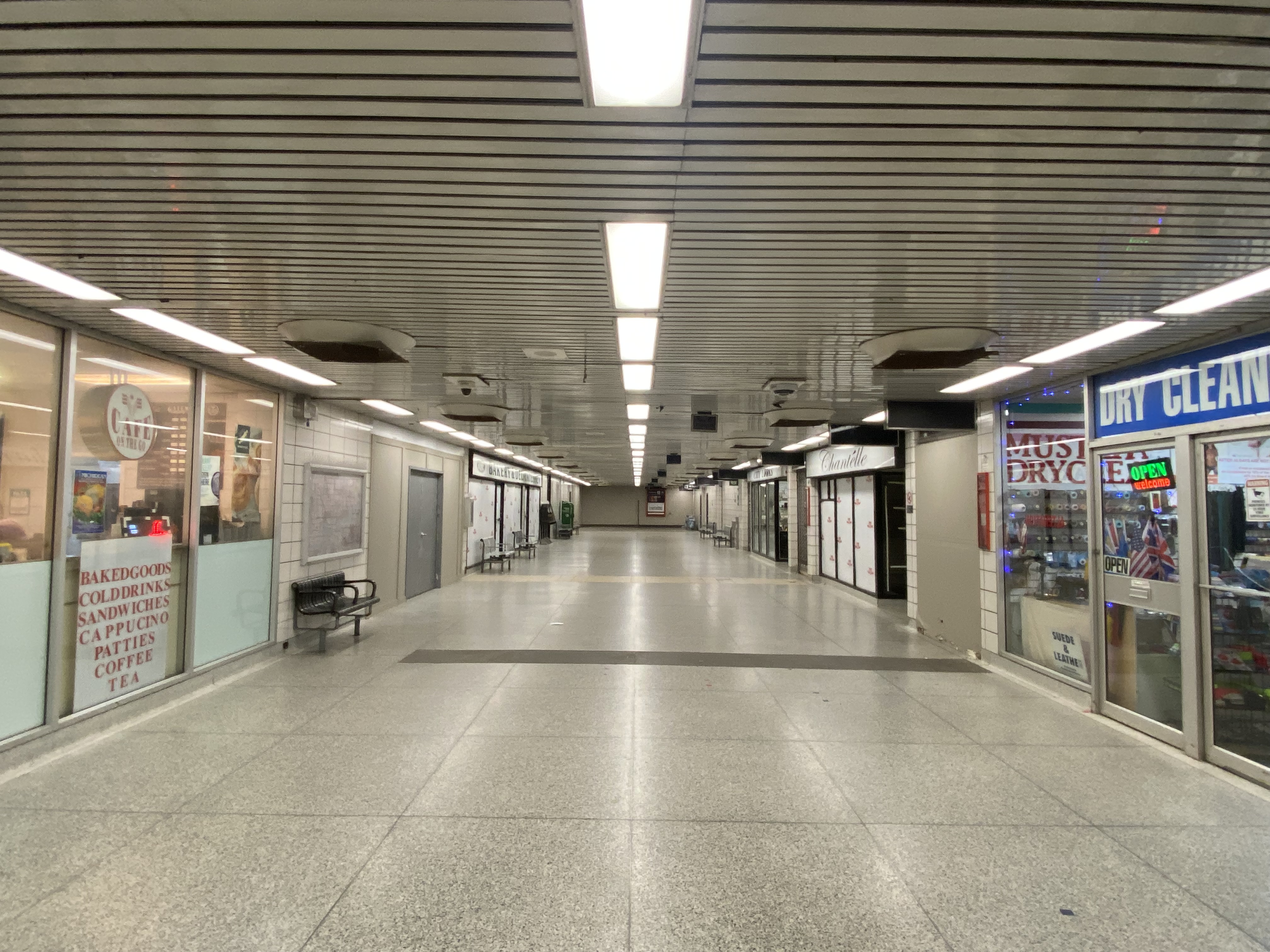
    At platform level, Islington looks little different than most stations on the Bloor-Danforth Line with the faded wall tile, coated with a layer of brake dust. Upstairs, on the concourse level and the old bus terminal, the station is in far worse shape. Wear and tear from hundreds of buses entering and exiting the station every day, along with water seepage from an underground stream, has caused the station to look much older than it actually is.

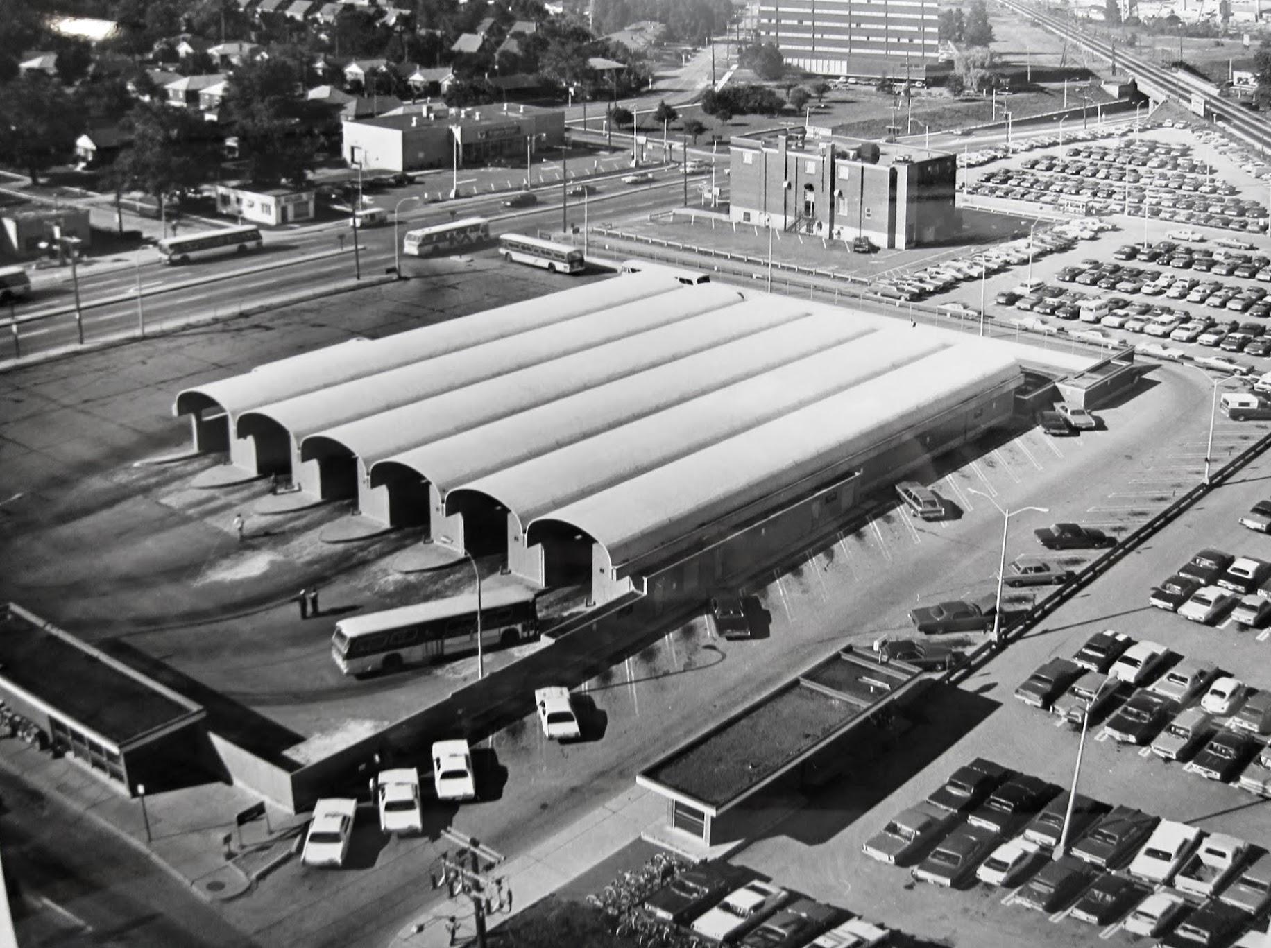
    From 1968 to 1980, Islington Station was the Bloor-Danforth Line’s western terminus, with buses branching out to points all over Etobicoke. The bus terminal boasted six bus bays, each with its own driveway. One of the six platforms was dedicated for Gray Coach services, which included an express bus to Pearson Airport.

    An arriving bus would first pull into the east side of the terminal, with all passengers descending a set of stairs to the subway concourse, either to transfer to the subway, exit the station, or transfer to another bus route. The bus, once the operator took their break, would then pull forward to the boarding area, where a second set of stairs emerged from a waiting area. Below, on the concourse level, a flashing light would alert waiting passengers that their bus was boarding. The terminal design was similar to the original bus terminal at Eglinton Station; at Warden Station, the levels are reversed, with the bus bays below the passenger concourse.

    Aerial view of Islington Station’s bus terminal in 1975, City of Toronto Archives, Series 836, Subseries 4, File 46. Note the Mississauga Transit bus passing by on Bloor Street.
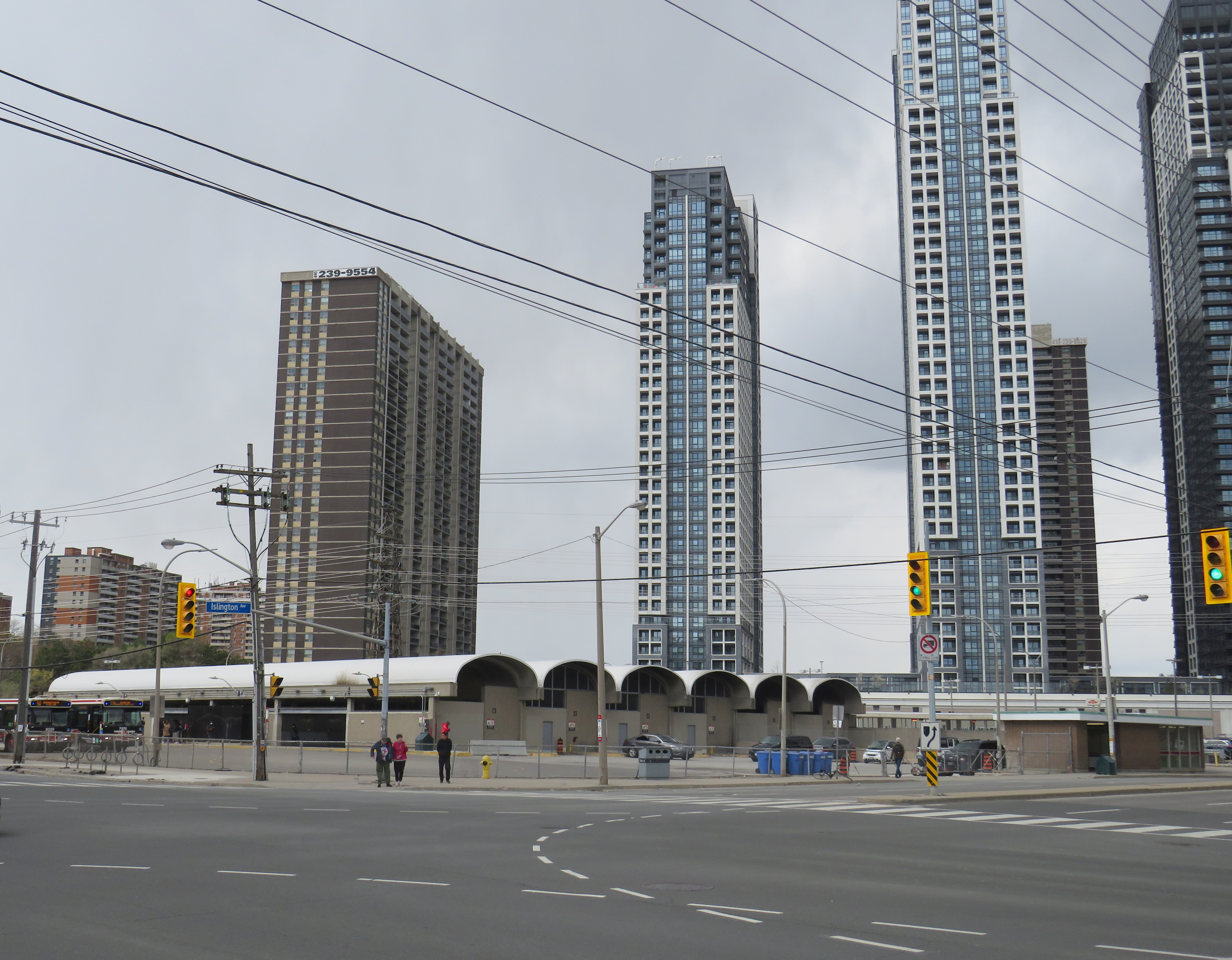
    Looking northwest toward the sealed-off bus terminal, May 2023

    In 1980, the subway was extended one stop westward to Kipling. The extension allowed the TTC to reroute most of its Etobicoke routes from Islington, which provided new space for Mississauga Transit, whose buses now loaded inside the bus terminal. (As the bus bays are inside the station’s fare-paid area, Mississauga Transit buses off-loaded passengers outside the station’s main entrance on Islington Avenue.) A seventh bay, located to the south of the original structure, was added to provide additional capacity for Mississauga Transit, however, only simple bus shelters provided protection from the rain and snow.

    But by 2016, the bus terminal area was starting to crumble, and bus bays 1 and 2 (the bus bays closest to the subway platforms) were closed permanently to prevent further structural damage. Mississauga and GO Transit planned for a new terminal adjacent to Kipling Station, but it was delayed by several years. Part of the delay was caused by Hydro One — owner of the transmission lines that parallel the subway and adjacent Canadian Pacific Railway corridor — who refused to allow a terminal building under its wires.

    The opening of the new Kipling terminal for GO and Mississauga Transit buses in May 2021 (repositioned to avoid the hydro corridor) allowed the TTC to permanently close the crumbling bus terminal bays. All remaining buses — 37/937 Islington, 50 Burnhamthorpe, and 110 Islington South — began only using the outer bus loading area in late 2021.

    Bus passage, Islington Station. Stairways to the old bus bays are sealed off, with the signs above the old stairways blacked out. Passengers transferring to TTC buses must walk to the far end of this corridor and then up a stairway to access the outer bus bay.

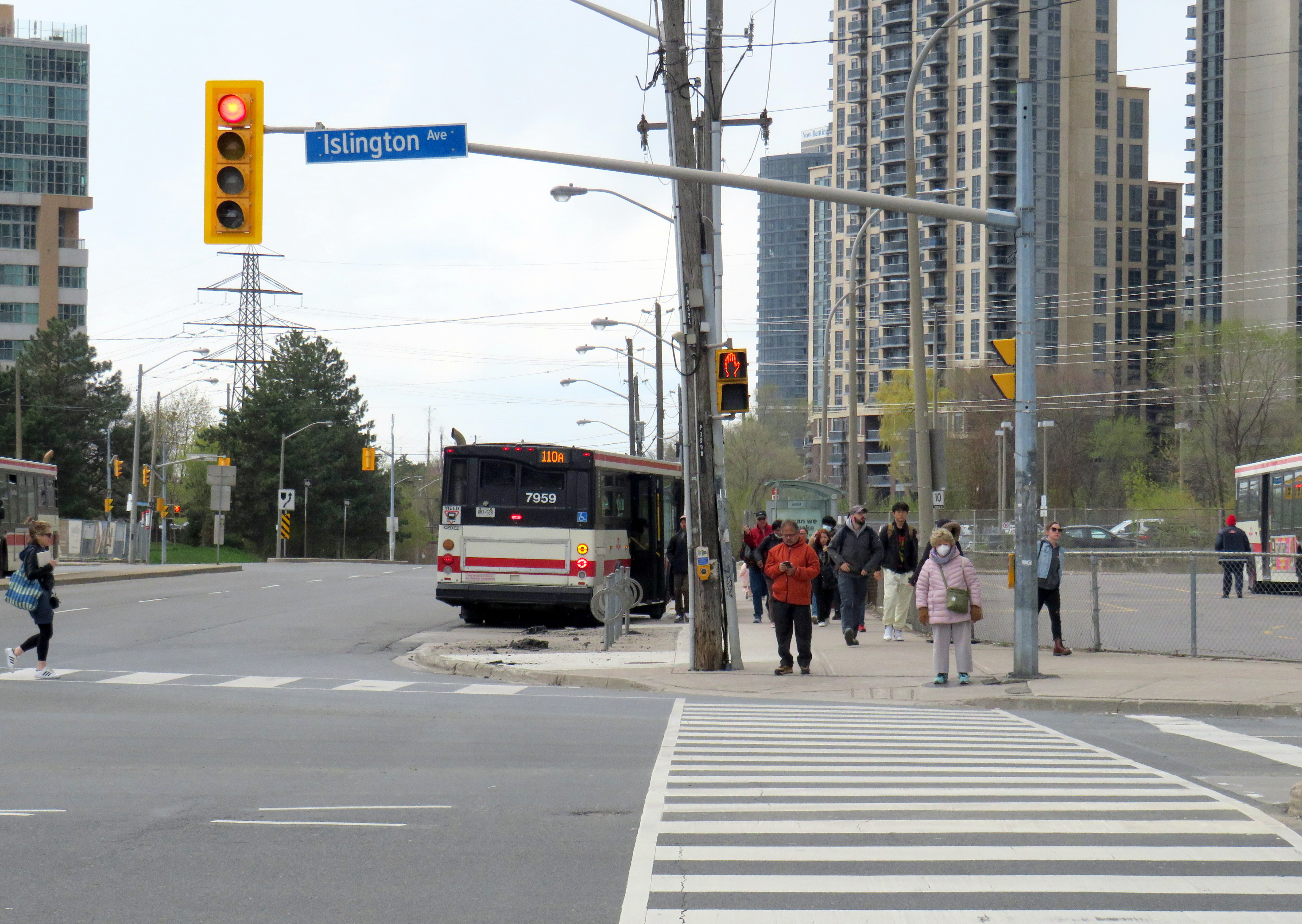
    With little room remaining for buses to load, offload, and layover, passengers on TTC buses arriving at Islington are now let off on the street and must walk to the main entrance and show their transfer or tap their Presto card to enter the subway or transfer to another bus. Though Route 37/937 and 50 buses stop right in front of the station entrance on Islington Avenue, Route 110 buses off load on Bloor Street, a two-minute walk to the subway entrance.

    A Route 110A Islington South bus off loads on Bloor Street; passengers must walk north to the subway entrance on Islington Avenue, to the right of this photograph

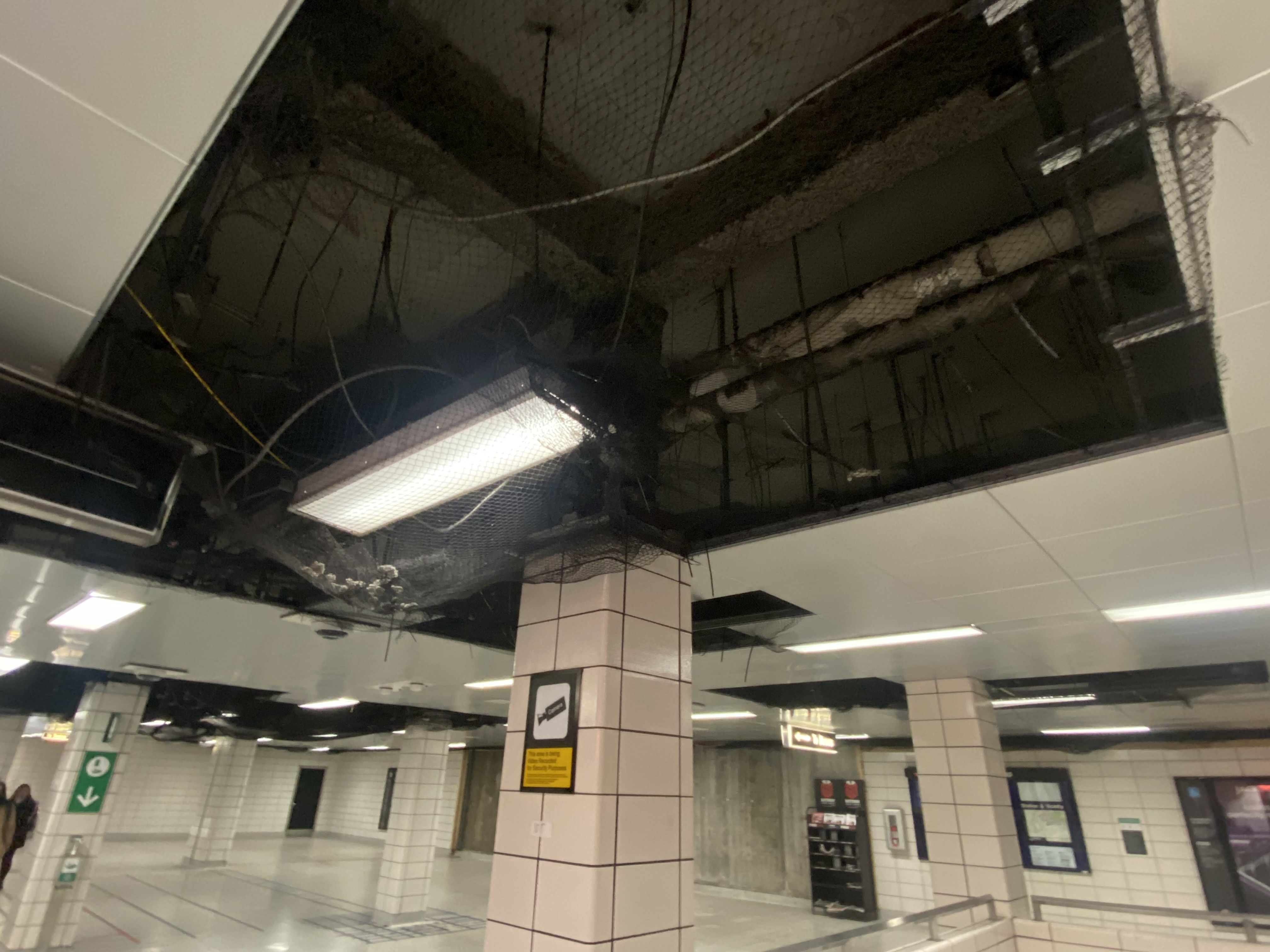
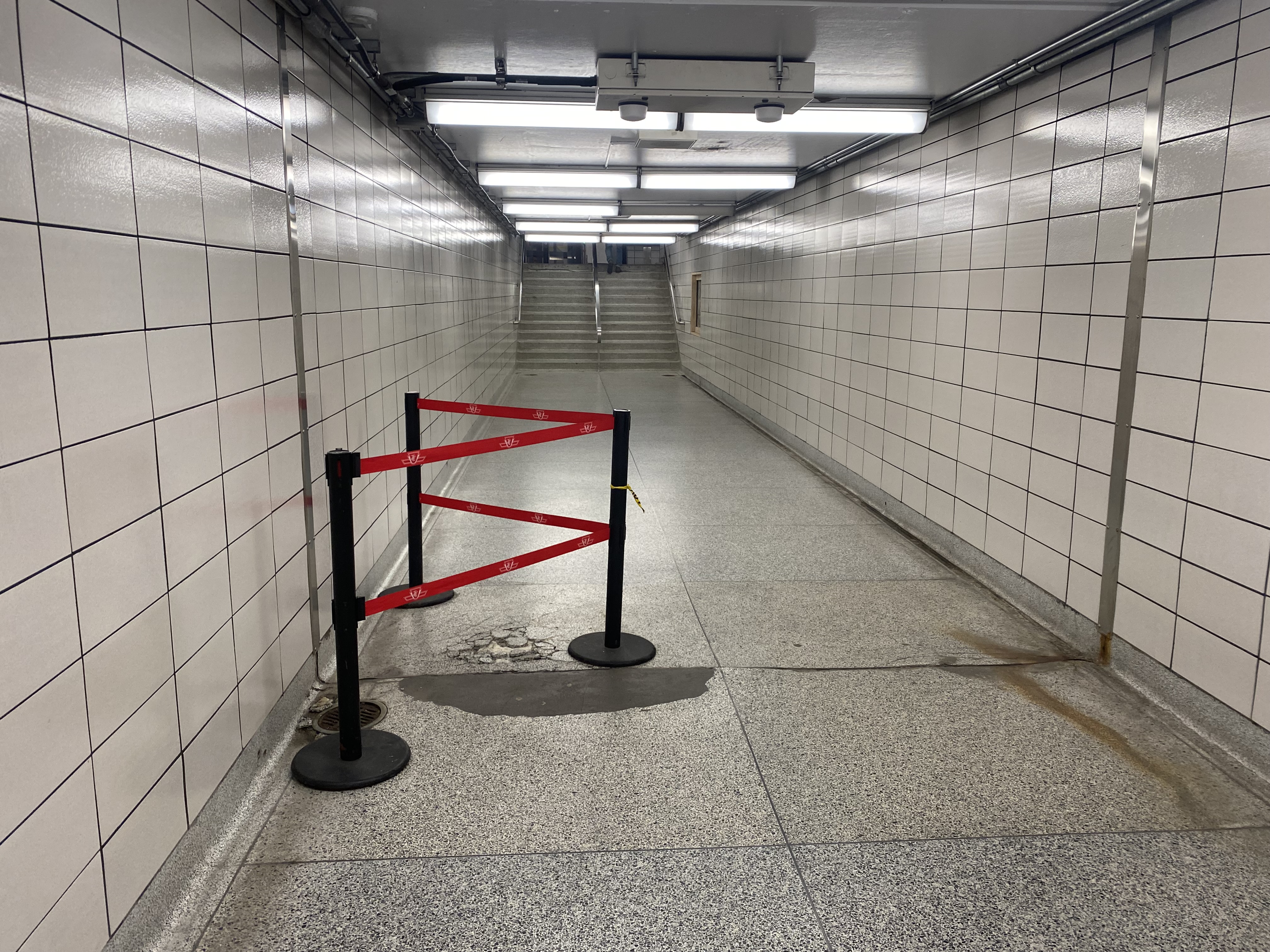
    Since the bus terminal closure, the decay at Islington Station has extended beyond the bus area. On the mezzanine level, ceiling tiles were removed, while black netting catches chunks of broken concrete. Removed wall tiles reveal crumbling concrete and exposed rebar. Water leaks cover the mezzanine floor. There are no signs advising passengers of work underway or future construction, though there have been several plans to rebuild the station and promote new development on the site.

    Fare gates partially obscured by temporary columns

    Not only is reconstruction needed to rectify the deteriorating state of the station, Islington is also one of 15 subway stations that still do not have barrier-free access for passengers using wheelchairs or other mobility devices. Islington and Warden were left at the bottom of the list for station retrofits largely due to the difficulty of providing barrier-free access. The outdated bus terminal layouts at those stations require complete redesigns, and both stations are good candidates for urban development.

    Netting keeps chunks of concrete from falling onto passengers’ heads
    Crumbling terrazzo floor in the passageway underneath Islington Avenue
    Water leak on the concourse level

    There have been several proposals for redevelopment at Islington, taking advantage of its large bus terminal area and parking lot. The city first looked at redevelopment in 2006. At that time, there was a proposal from engineering firm SNC-Lavalin for a new office building that would incorporate a rebuilt station. However, that proposal deal fell through.

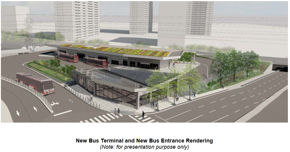
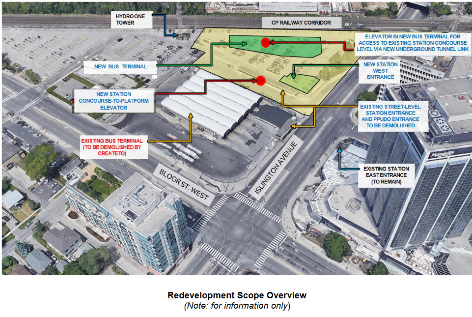
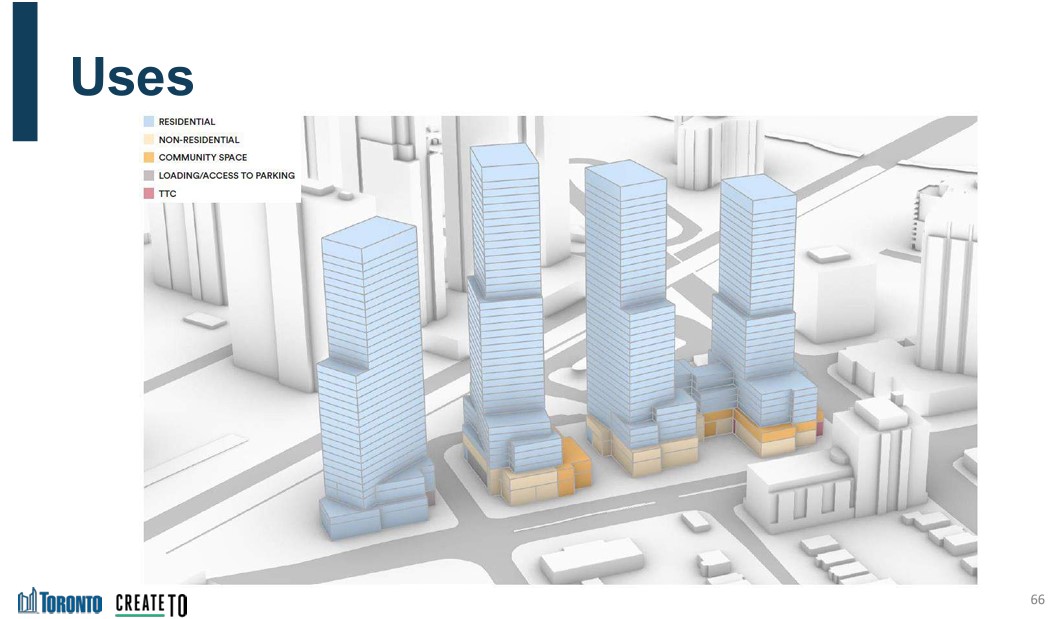
    In 2021, a new plan to rebuild the station was presented to the public. It would include a new six-bay bus terminal in the commuter parking lot north of the existing terminal. Upon completion, the old bus area would be redeveloped under the city’s CreateTO housing program. Aberfoyle Crescent, which connects Islington Avenue and Bloor Street, would be extended through the station property to provide bus access and allow for development of the rest of the station property. The site is constrained by the same Hydro One corridor that stymied construction of the new Kipling terminal (much of the parking lot is under hydro wires), but this is a much smaller bus terminal, and hopefully lessons were learned this time.

    Work on station construction was scheduled to begin in Spring 2023.

    Rendering of new bus terminal and station entrance
    Schematic of the TTC station redevelopment
    CreateTO development blocks at Bloor and Islington, from 2021 presentation
    Create TO conceptual plan for Islington Station site

    It is now mid-June 2023, and for now, there is no sign of work. Inside the station, there are no signs informing customers of impending construction, even if only to reassure passengers that the decrepit conditions are being addressed.

    The many delays at Islington Station are also indictive of the difficulties of redeveloping even city-owned properties for new, much needed housing. It won’t be until 2026 — at the earliest — that new development can take place.

    Until then, TTC customers must put up with a rapidly deteriorating station.

  • GO’s gaping gap, gone

    GO’s gaping gap, gone

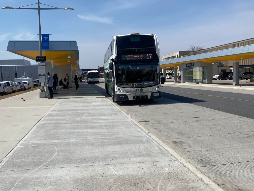
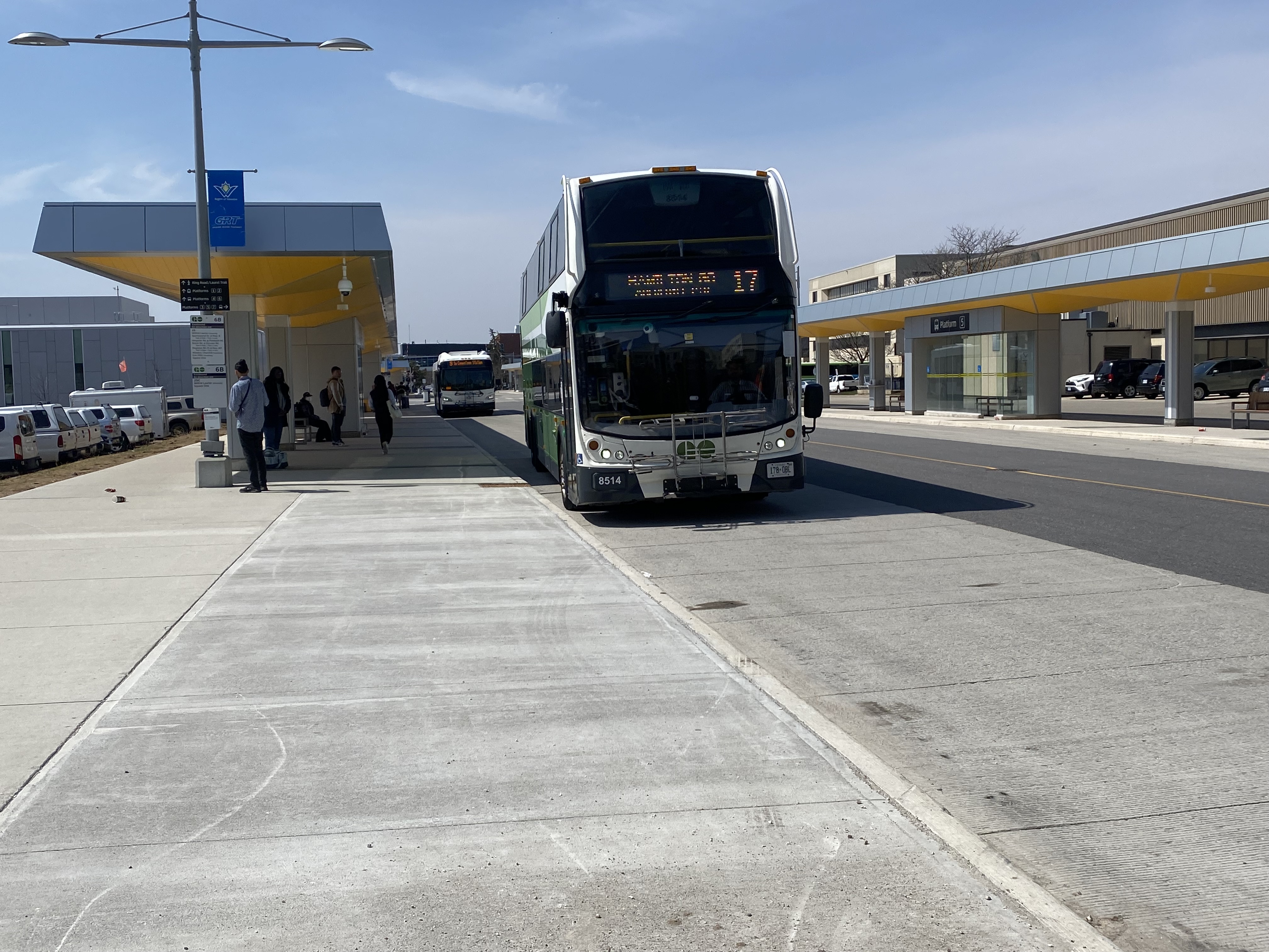
    Route 17 bus arriving at University of Waterloo Station

    On Monday, April 10, 2023, GO Transit filled a big hole in Ontario’s intercity transportation web with Route 17, which connects three major urban centres, four universities, and two existing GO Transit rail corridors. On that day, I made my way to Waterloo and rode one of those first buses south towards Hamilton. Nearly a month later, I made a second trip, from Guelph and Downtown Hamilton, on May 5.

    Sign post at University of Waterloo indicating the stops for Route 17

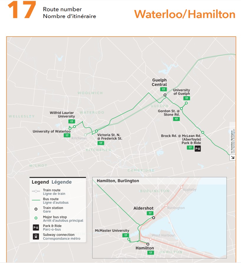
    The bus originates at the new University of Waterloo bus terminal, located adjacent to the Ion LRT corridor and on the far east side of the university campus. It then stops in front of Wilfrid Laurier University, on Victoria Street North in Kitchener’s east end, at Guelph Central Station, University of Guelph, the park & ride lot in Aberfoyle, Aldershot Station, McMaster University, and Hamilton GO Centre.

    Waterloo-bound Route 17 bus at Guelph Central Station, May 5, 2023

    On the first day, the experience was more interesting than I expected, as the driver, new to the route, missed the turn from the Hanlon Expressway (Highway 6 through Guelph) towards Downtown Guelph. Luckily, dispatchers were able to guide the driver back on route after a short delay, so it only made for a roundabout tour of some of Guelph’s residential neighbourhoods, where GO Transit has certainly not gone before (and probably won’t, ever again).

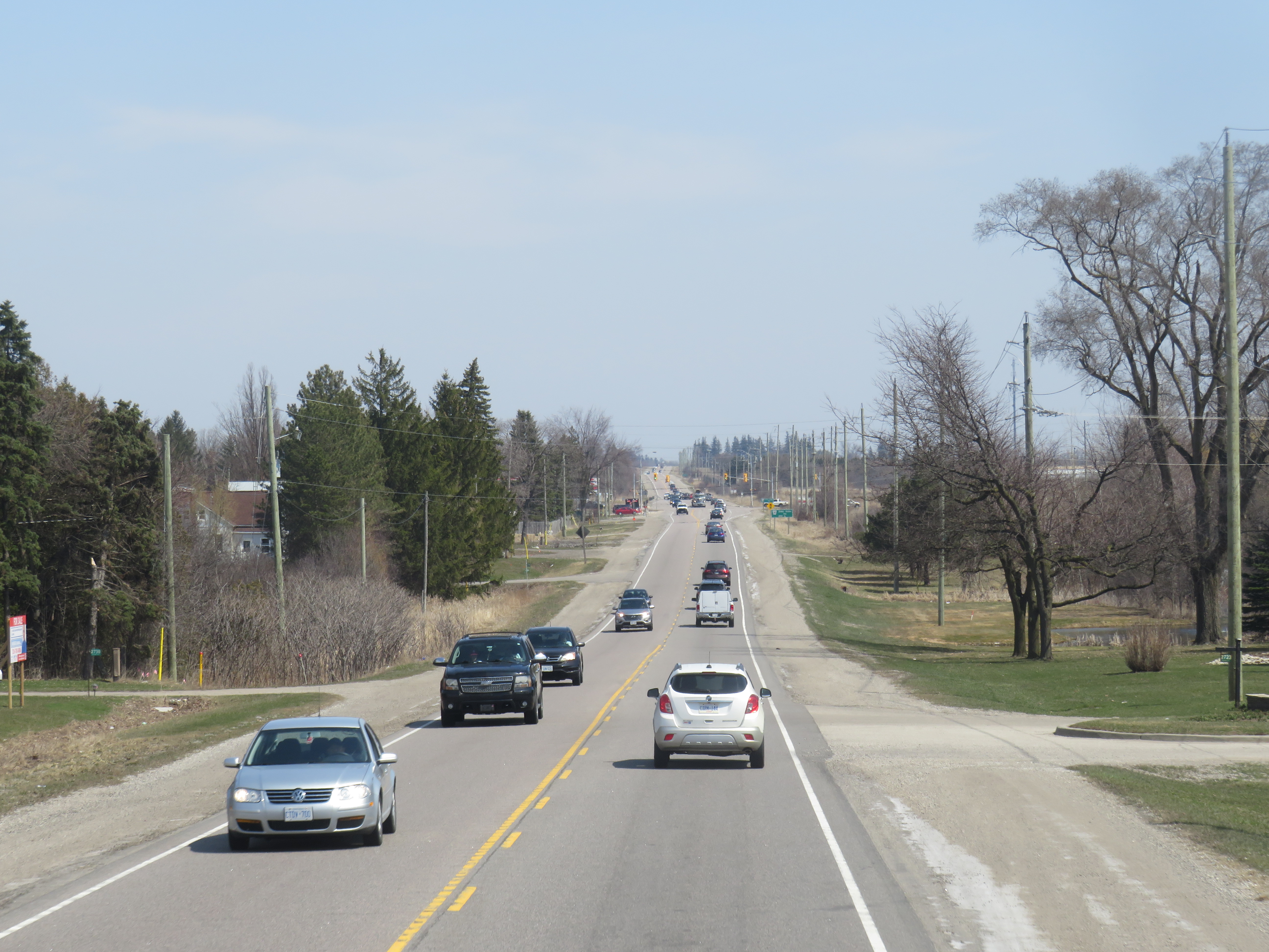
    On congested Highway 7 between Kitchener and Guelph

    Sitting at the top of the front of a double decker bus (so far, I had my choice of seats as the route is still new and not too busy) gave me a view of the traffic congestion in the western Greater Golden Horseshoe. Highway 7 between Kitchener and Guelph is still a two-lane road, without even paved shoulders to make it a bit more cycling friendly. Though there are a few GO trains on the adjacent railway, the service is sporadic and only runs on weekdays. A new four-lane freeway has been planned for decades, with some preliminary work started, but a regular two-way, all-day train service, and more bus links to places like Cambridge, would be even more effective in meeting travel demands in the region.

    Highway 6 south of Highway 401 is also very congested, and a new highway bypass is planned to divert traffic around a two-lane section through Morriston and Puslinch Station. Clearly, there’s a lot of travel demand between Kitchener-Waterloo, Guelph, and Hamilton, but transit options have always been severely limited.

    Thankfully, Metrolinx is upgrading the western portion of the Kitchener Line, with a second platform under construction at Guelph Central Station, and work started on new passing sidings between Kitchener and Georgetown. But it will be several years at least before the upgrades allow for regular, two-way, daily passenger rail, so the bus will have to do.

    At Aldershot Station

    In my review of GO’s service changes earlier this month, I argued that Route 17 was trying to do too much with a single bus route. Riding the corridor from end-to-end (albeit on two separate occasions), I could not help but feel frustrated by the southern end of the route, where the GO bus goes east on Highway 403 to connect with Aldershot Station, then backtracks to get to McMaster University, then turns around to get to Downtown Hamilton. I understand that all three destinations are important trip generators (Aldershot allows passengers from Burlington, Oakville, and southern Mississauga to get to Guelph and Waterloo, McMaster University is a reliable trip generator, and Downtown Hamilton is a busy urban hub), but for someone to get between Hamilton and Guelph or Waterloo, it’s a long way out of their way.

    I am hopeful that GO Transit uses the summer down time to see where passengers are going and coming from and make route adjustments or add express runs once classes resume in September.

    Map of GO Transit Route 17

    A note on Route 21

    Last month, when previewing the new GO Transit changes, I discussed the changes to Route 21 (the Milton Corridor train-bus service), in which most buses were pulled from Union Station, instead diverted to three stations on the Lakeshore Line. Though at the time, I explained that the change made sense given severe traffic delays on the Gardiner Expressway and around the new GO Bus Terminal, it would mean a longer trip, and an unpopular transfer.

    I underestimated the aggravation and anger transit riders had when the new schedules were put into service. The loss of direct GO bus service between Milton and Mississauga along Derry Road is also a new gap that should be re-filled.

    I suggest three changes, though I acknowledge that the continued shortage of train crews and budget issues might make these more difficult:

    • Restore 15-minute rail service on the Lakeshore West corridor. This would at least ensure that transferring Route 21 customers aren’t stranded up to 30 minutes at Oakville, Clarkson, and Port Credit stations. Since GO Transit’s ridership has recovered faster off-peak versus peak periods, the extra capacity will be helpful.
    • Restore all-day, regular bus service on Derry Road between Milton and Meadowvale, perhaps extending to Bramalea Station and/or Highway 407 terminal. This would provide new connections, including the new weekend Kitchener Line trains.
    • Extend more buses between Square One and Kipling Terminal. Though the new Kipling Station bus terminal was a Metrolinx project, only Route 29 (Guelph-Square One-Kipling) uses it. It could then be an alternative to transferring to Union Station for some passengers.

  • Brampton LRT: a second chance to get it right

    A mock-up of a Bombardier Flexity tram sits in Gage Park while a Brampton Züm bus passes by in 2013

    On Wednesday, May 10, Brampton’s Committee of Council will consider a staff report on the proposed extension of the Hurontario LRT north from Steeles Avenue to Downtown Brampton.

    This section of the LRT, planned last decade, was narrowly rejected by Brampton City Council in a 6-5 vote, with then-mayor Linda Jeffrey supporting the transit line’s construction. Unfortunately, six city councillors sided with several downtown merchants and affluent Main Street South residents (including former premier Bill Davis), who did not support a surface tram on Main Street, back in October 2015.

    Councillors who voted to reject the Main Street alignment later backed the study of slower, more indirect alternative routes, while voting to ask Metrolinx and the provincial government, which was planning the line, to terminate the LRT on the south side of Steeles Avenue to allow for their potential fantasy options. Unfortunately, Metrolinx obligated.

    In 2019, a newly elected council, led by a new mayor, Patrick Brown, was willing to revisit the LRT decision, again backing a direct Main Street alignment. City staff were directed to update the original, approved 2014 Transit Project Assessment Process (TPAP). In 2021, staff narrowed the alternatives to just two options: an all-surface alignment from Steeles Avenue to the GO station in Downtown Brampton, and an underground option between Nanwood Avenue and the rail corridor. Meanwhile, Brampton staff and elected officials tried, without success, to restore the north-side LRT terminal at Steeles Avenue/Gateway Terminal.

    Now that the 30% design work for the two options is complete, city officials must decide how to proceed, especially if they expect senior levels of government to cover the costs of this major transit project.

    The alignments

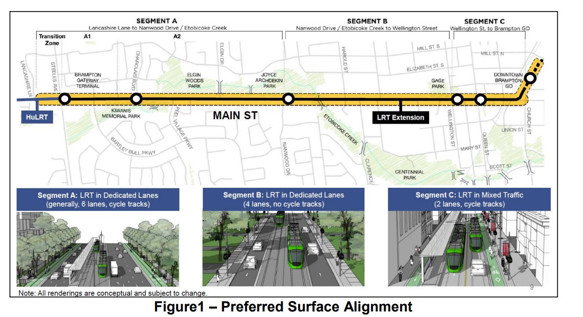
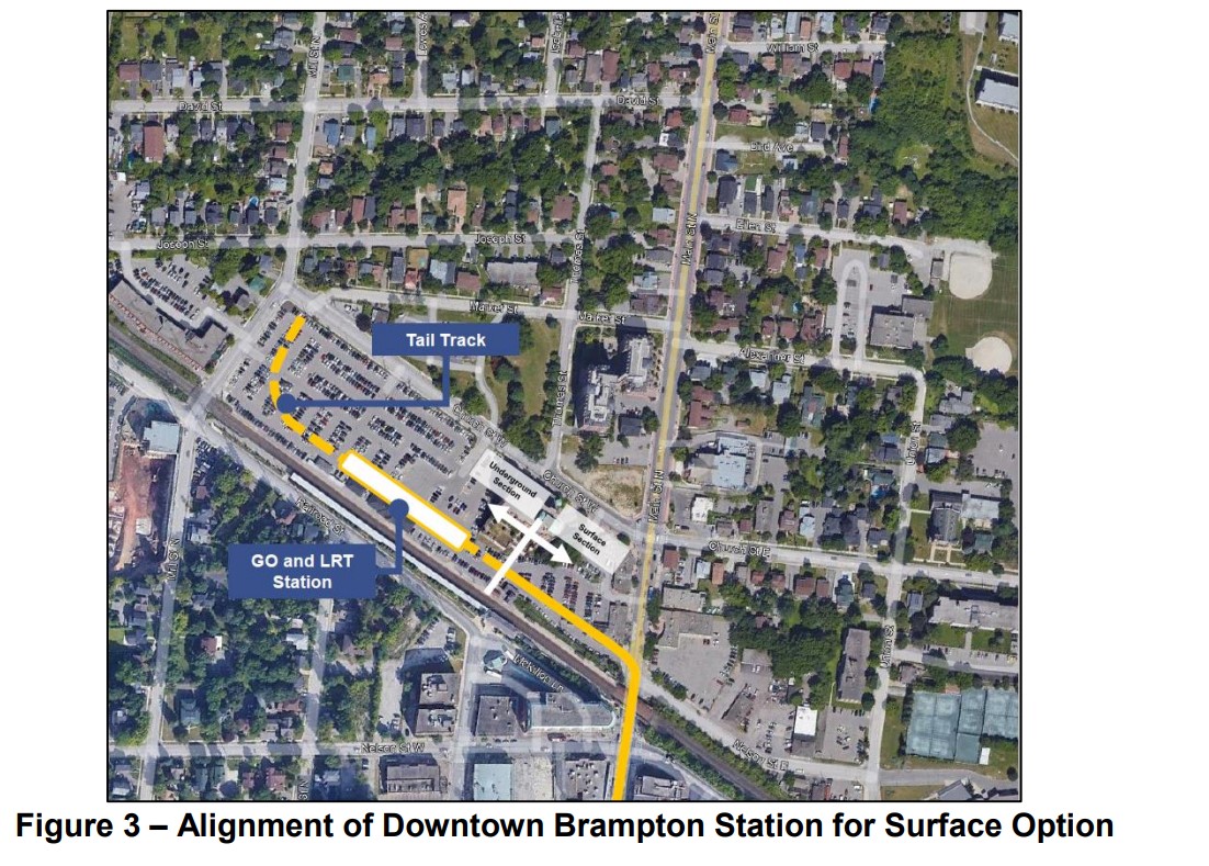
    The all-surface alignment three stops in each direction between the Gateway Terminal at Steeles Avenue and the Brampton GO Station: at Charolais Boulevard, Nanwood Drive, and split northbound and southbound stops between Wellington and Queen Streets. These stop locations match the existing 502 Züm Main stops on this section of Main Street.

    Between Nanwood Drive and Wellington Street, the LRT would operate in dedicated lanes, with general traffic in the outer two lanes. There would not be room for bicycle lanes, and left turns would be prohibited at non-signalized intersections. North of Wellington, the LRT would run in mixed traffic, with cycle tracks and widened sidewalks on both sides of the street.

    The preferred surface alignment

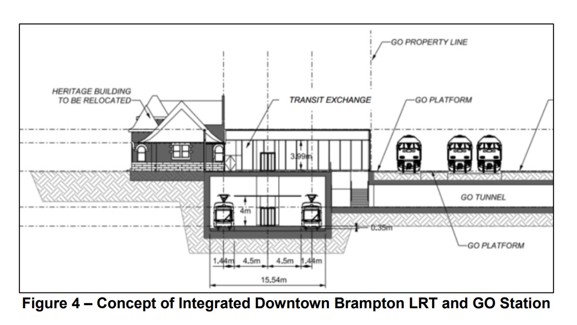
    The northern terminus would be on the GO Station property, on the west side of Main Street, in a below-grade trench. Stairs and elevators would connect the platform with the GO Station, while the historic 1907 station building would be moved to support GO train service expansion on the busy CN freight corridor. The street surface would need to be lowered by one metre for the light rail vehicles and the overhead wire to clear the railway underpass.

    Alignment of off-street surface LRT alignment on the GO Station property
    Design concept for the GO and LRT terminal

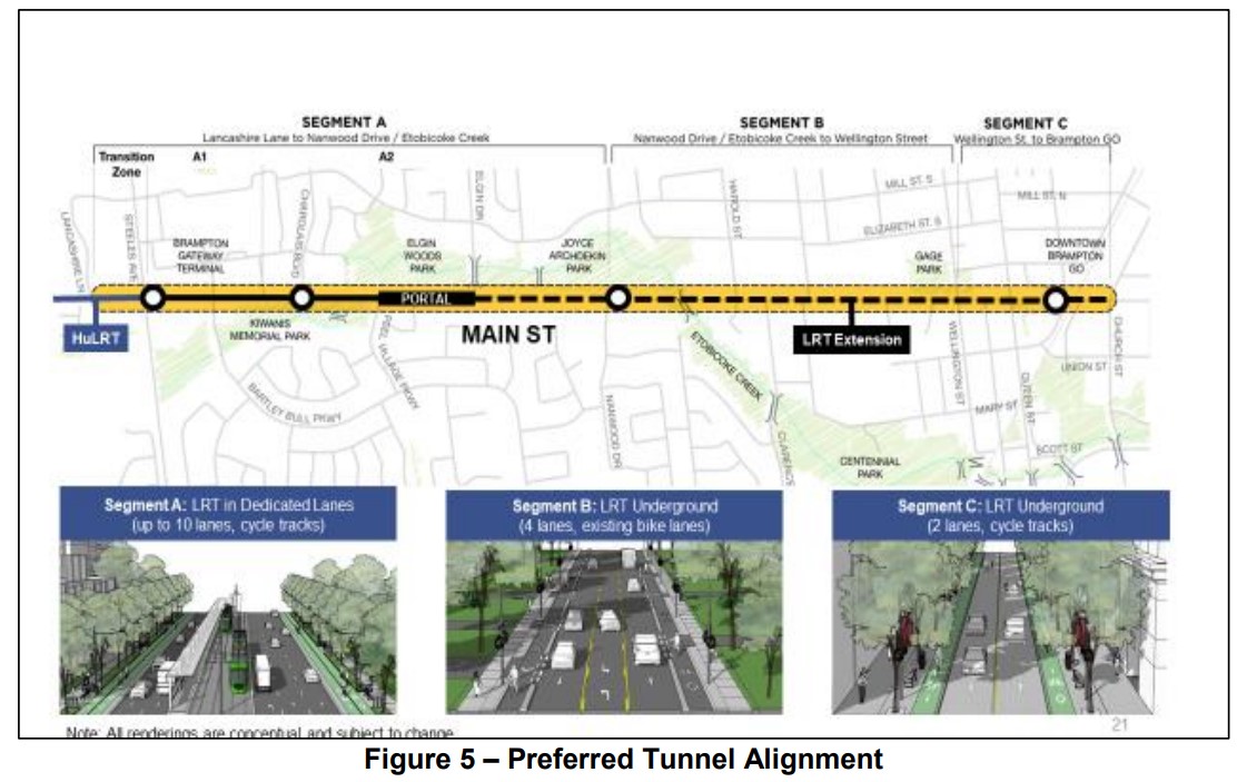
    The tunnel alignment – which was not part of the approved 2014 TPAP – includes the same surface stops at Brampton Gateway Terminal and Charolais Boulevard, and two underground stations, at Nanwood Drive and the terminal, just south of the GO Station. Between Elgin and Nanwood, the tunnel would be dug in the traditional cut-and-cover method while the portion under Etobicoke Creek and the downtown core would be constructed using the sequential excavation method.

    The tunnel portal would be located at Elgin Drive, several hundred metres south of Nanwood. The longer tunnel section is required to avoid the Etobicoke Creek floodplains. Though Nanwood Drive has no intersecting transit routes and relatively low density, the rundown Brampton Mall property would be an ideal urban development site, as would the commercial properties immediately to the south.

    The preferred tunnel alignment

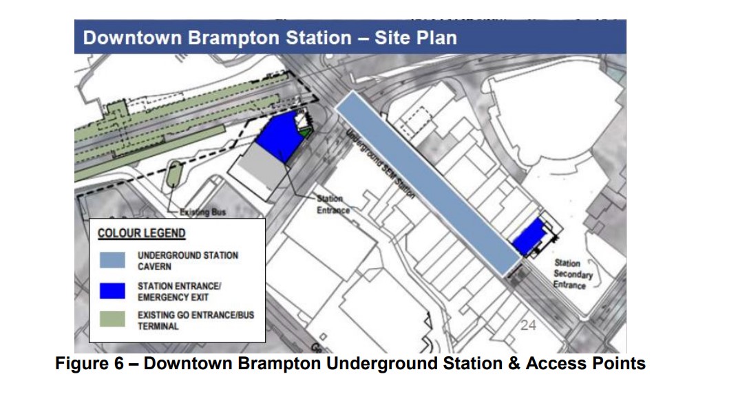
    The downtown terminal station would include a primary access at the corner of Main and Nelson Streets, to provide access to the GO Station and the proposed new transportation hub, as well as a secondary entrance closer to Queen Street and Garden Square.

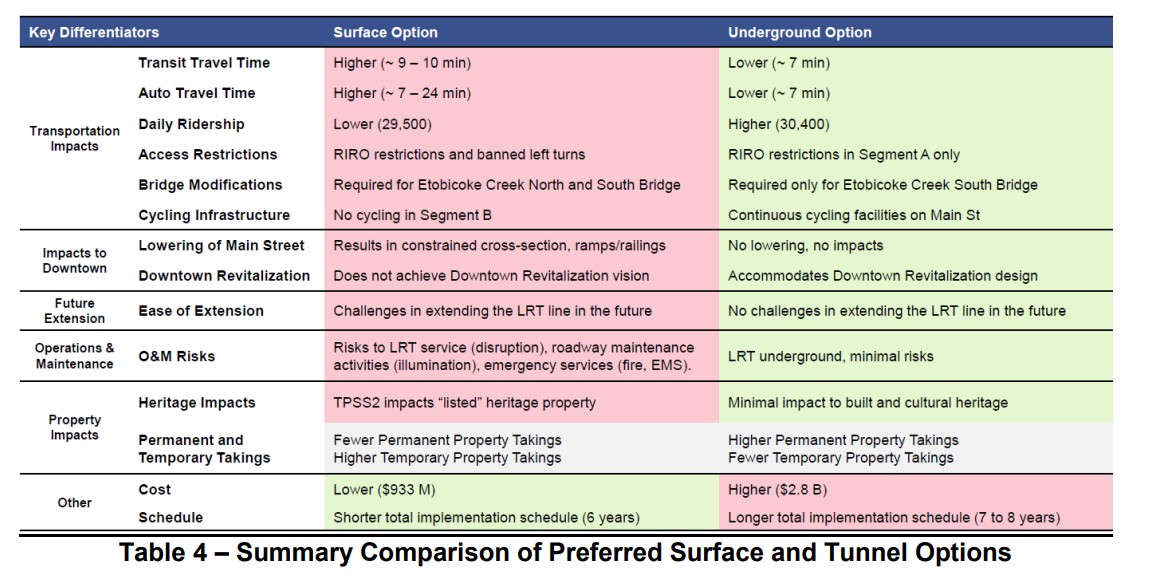
    The two options were compared, putting the tunnel alignment ahead in all categories apart from cost and schedule. The tunnel would allow for continuous cycling infrastructure on Main Street, minimize traffic impacts, while having slightly higher ridership and somewhat faster transit. The tunnel would also better satisfy homeowners and businesses along the corridor. Staff also note that the tunnel alignment, without the bend into the GO station property, would be easier to extend farther north.
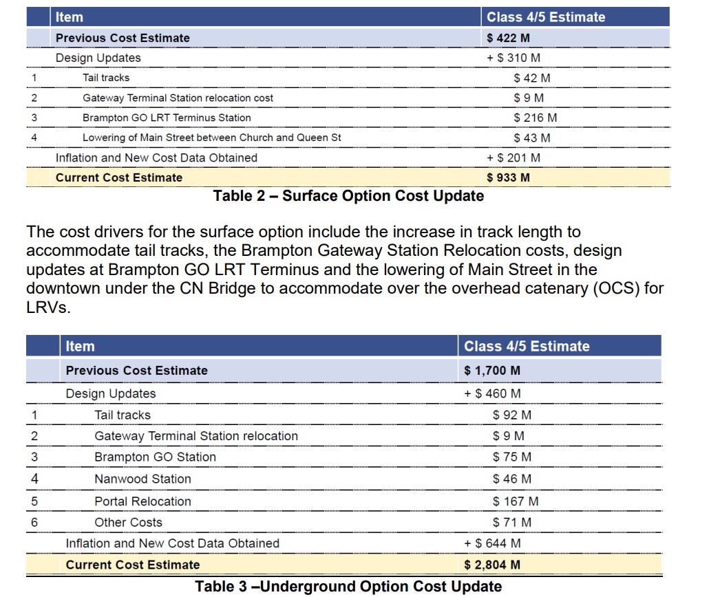
    As with other transit projects, the costs of delaying this segment of the LRT are subject to inflation. The surface alignment would cost $933 million, while the tunnel route would cost $2.8 billion. The surface option would take one to two fewer years to complete, an important consideration given Brampton’s fast-growing transit ridership and delays on other complex LRT projects, such as the Eglinton-Crosstown line.

    Cost comparisons for the tunnel and surface alignments

    The Pitch

    Towards the end of the staff report is a section called “Funding Advocacy.” Staff rightfully point out the need for the LRT extension, given the city’s and the province’s goals of directing high density development to the downtown core and other transit station areas, as well as the city’s record of continuous ridership growth and transit improvements.

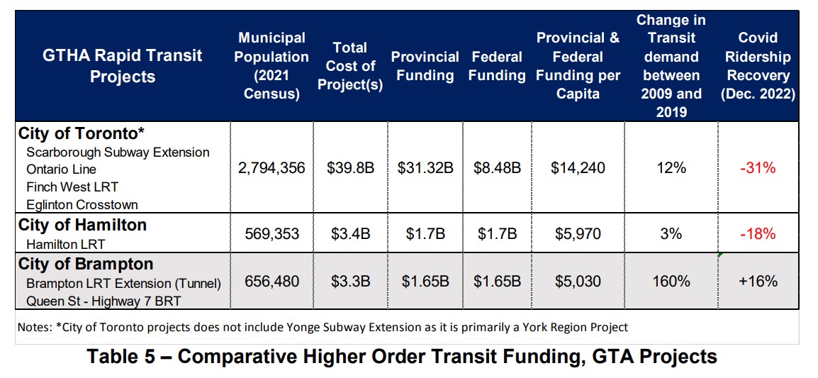
    They also point out that the funding that Brampton is seeking (for the Queen Street BRT project and the LRT, specifically the tunnel option) is comparable to other transit projects in the Greater Toronto and Hamilton Area. The table below compares the costs and funding sought for Brampton’s proposed projects to those funded and underway in Toronto and Hamilton.

    Table comparing costs, funding and system ridership for Toronto, Hamilton, and Brampton

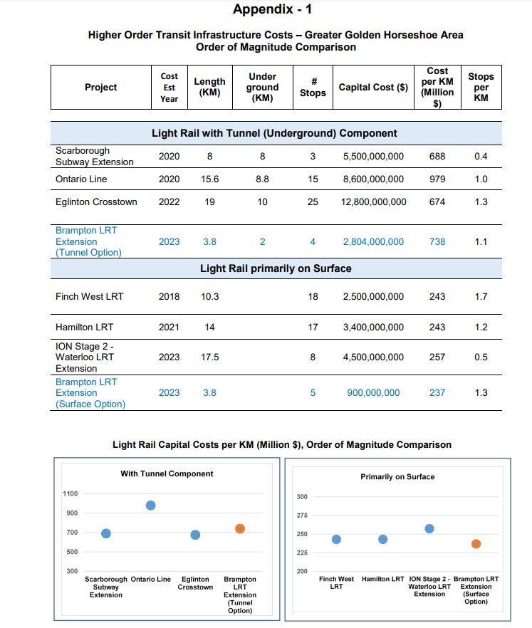
    An appendix to the staff report compares the cost of the tunnel option with other tunnelled Ontario projects (the Scarborough Subway Extension, the Ontario Line, the Eglinton-Crosstown), and the surface alignment with other surface projects (Finch West LRT, Hamilton LRT, Ion LRT extension in Cambridge).

    Concluding thoughts

    It is still a shame that Brampton City Council put the interests of a small, but affluent, minority of voters first back in 2015-2016. Had they not prevailed, the LRT into Downtown Brampton would have been under construction right now – at the same time that critical water infrastructure is being replaced in Downtown Brampton, and we would be looking forward to it being open in just two years. However, just three of the eleven council members that voted on the LRT in 2015-2016 remain at Brampton City Hall, and two of those three councillors supported the original project.
    The arguments in favour of the tunnel are enticing: a faster transit ride though a congested part of the city, an appeal to provincial and federal governments that have historically short-changed Brampton on its infrastructure needs, in a city that will have six seats up for grabs in the next elections.
    However, a surface LRT will be quicker and much cheaper to build. I also do not see the need for further extensions northward, at least via Main Street, and even then, it would require a second tunnel portal somewhere near Vodden Street, adding at least $1 billion to future costs. The GO station terminal points towards the abandoned Orangeville-Brampton Railway, which could provide a good alignment northward from Downtown Brampton, even with a parallel cycling path.

    More than anything, I want to see the Hurontario-Main LRT completed to Downtown Brampton as soon as possible, especially as work progresses on all-day hourly train service between Toronto and Kitchener and revitalization and intensification of Downtown Brampton accelerates.

    The provincial government has signaled that they prefer the surface alignment for cost reasons (notwithstanding it spending billions of dollars on an unnecessary tunnel on Eglinton West in Etobicoke), as does the Brampton Board of Trade. It is also worth noting that this study is only at the 30% design phase, detailed engineering work may find further costs.

    The surface option was the right choice in 2015, and it remains the right choice today. This time, maybe, Brampton will get it right.