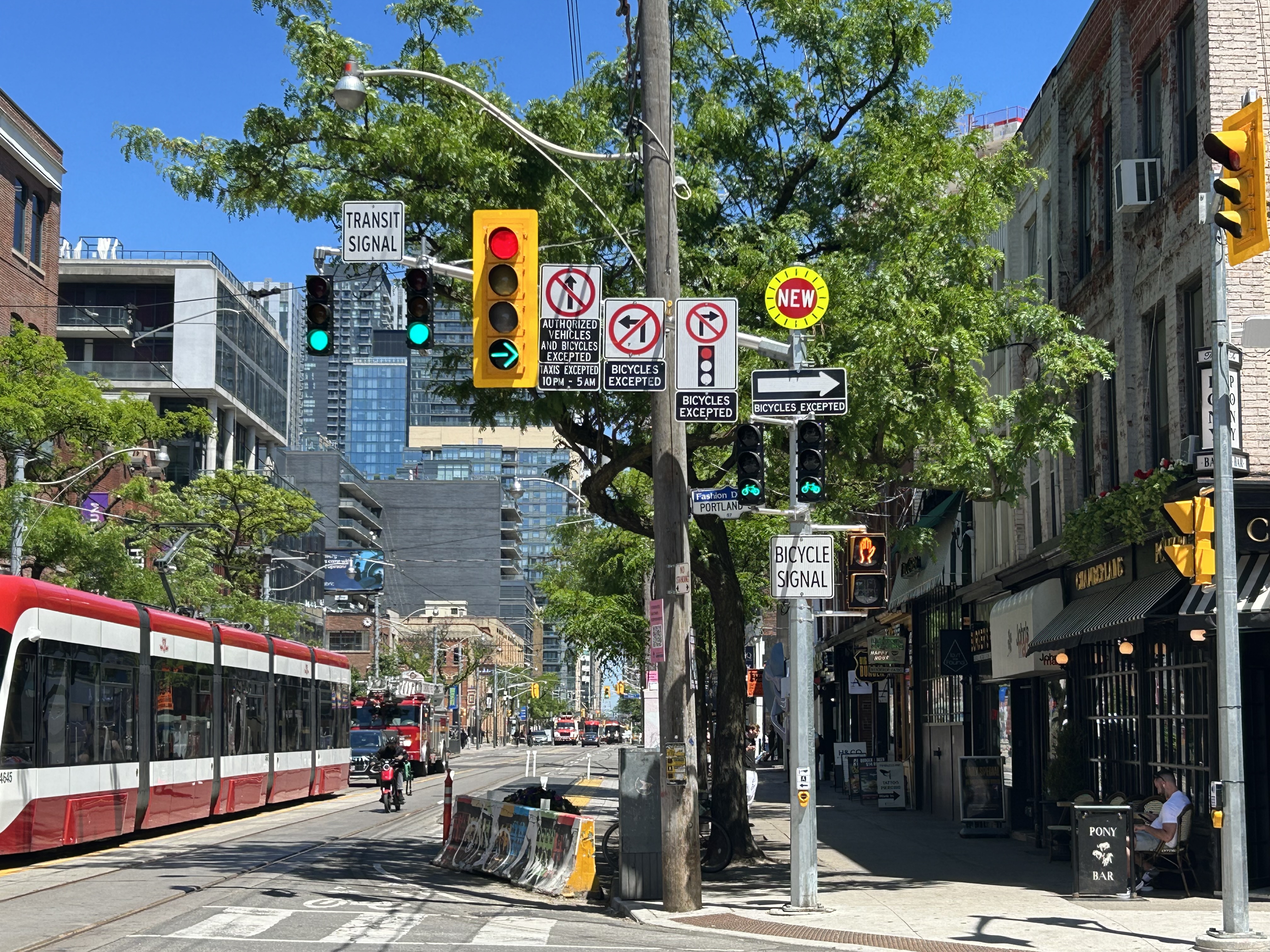
A mess of signs and signals on King Street West at Portland Avenue
On a lovely weekday afternoon in early June, I went for a ride through Downtown Toronto to check out the changes to Portland Street between Richmond Avenue and Front Street. This side street, just west of the downtown core, connects the busy Richmond-Adelaide cycle tracks with the Puente De Luz walking/cycling bridge across the Union Station Rail Corridor to CityPlace and via Dan Leckie Way to the Waterfront.
While the City of Toronto is currently restricted in adding new cycling lanes on major corridors, it continues to piece together alternative routes where possible; Portland Street, which parallels congested Spadina Avenue and Bathurst Street, is one of those opportunities. A new two-way cycle track was opened while most of Portland Street itself is now one-way for motorists.
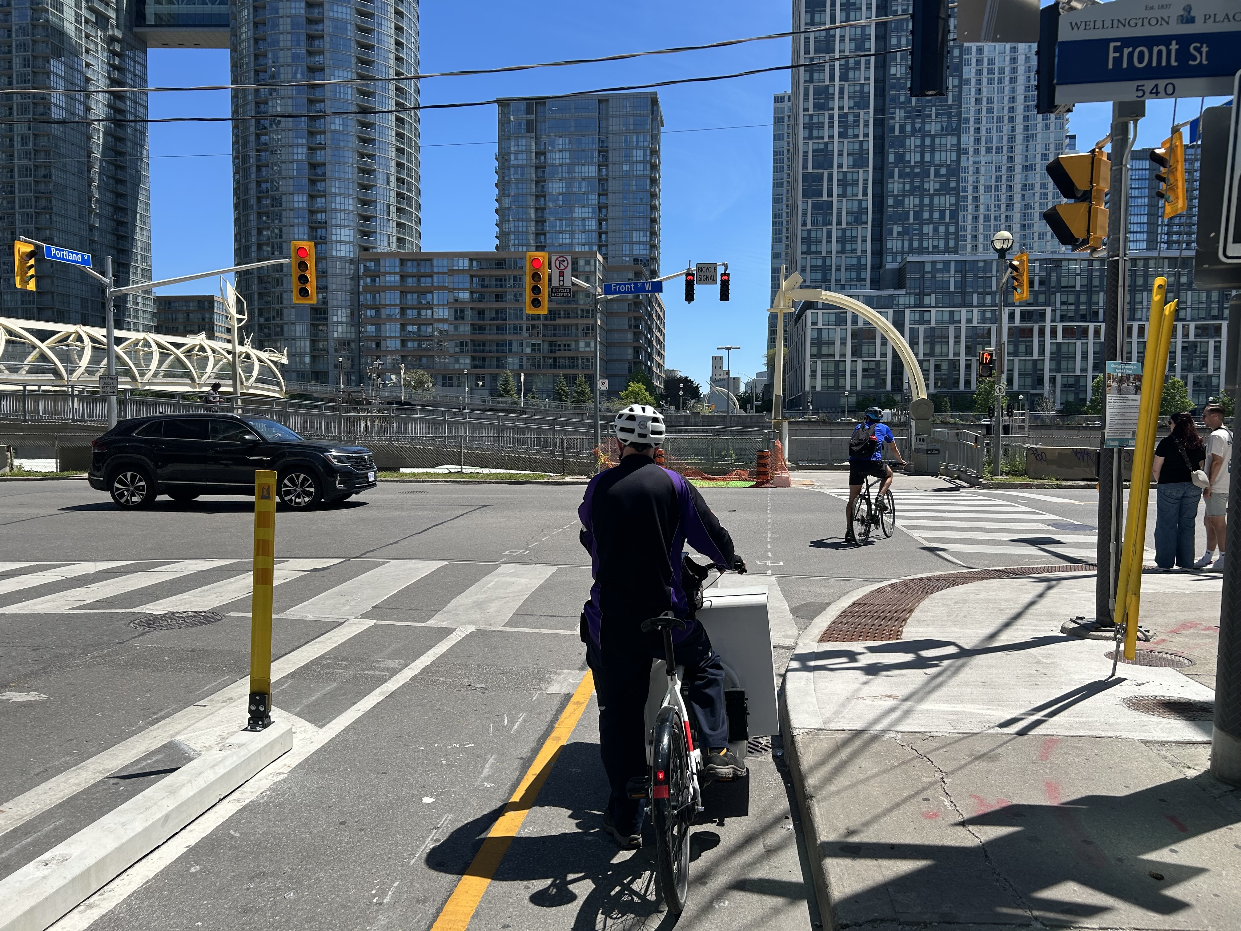
Looking south at the end of Portland Street towards CityPlace and the ramp to the Puente De Luz Bridge (bridge at far left)
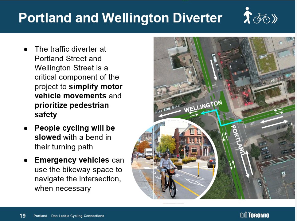
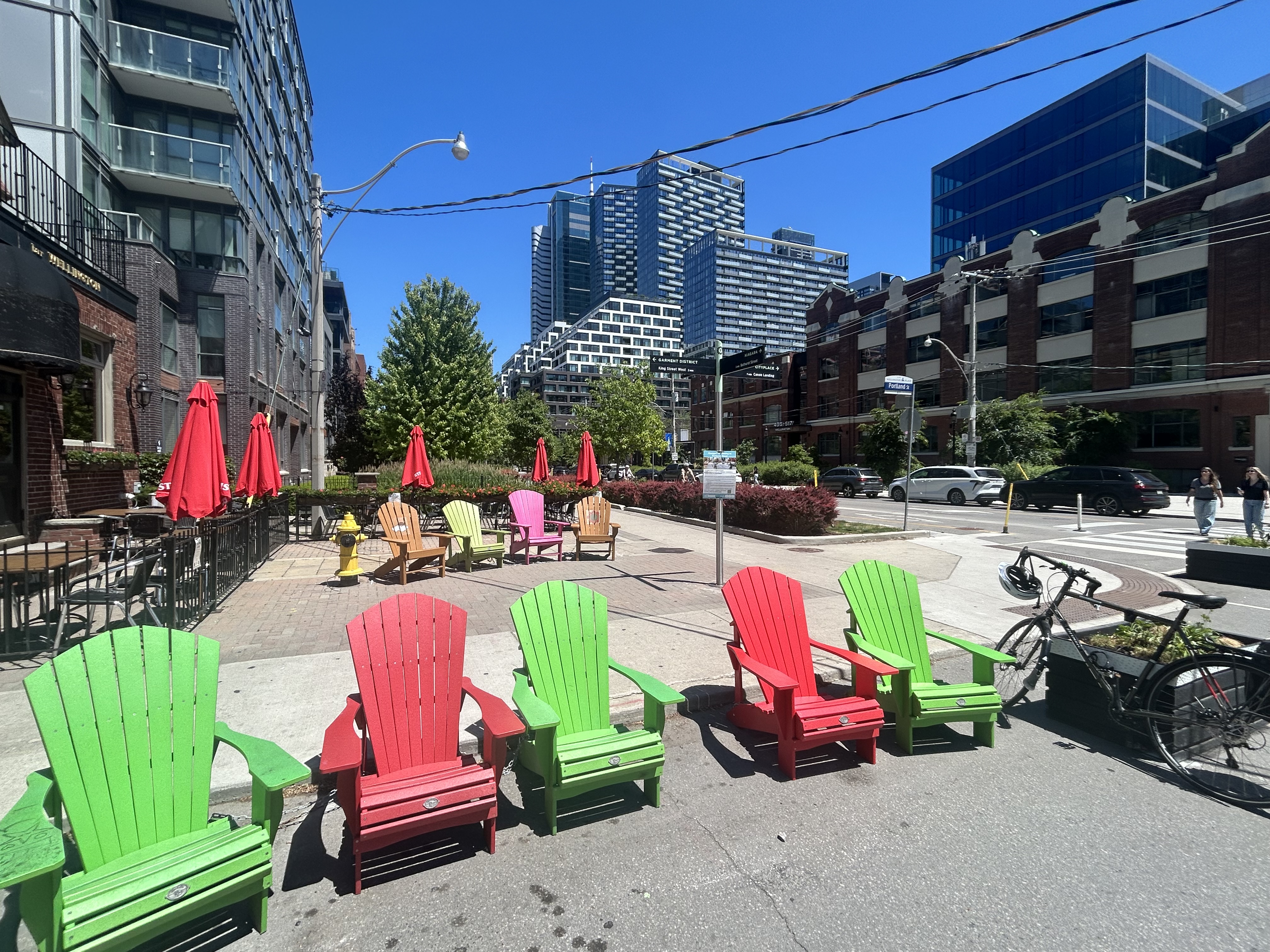
At Portland and Wellington Streets, an interesting new traffic alignment diverts motor traffic around the complex intersection while permitting through cyclist and pedestrian movement on all sides, improving safety for all road users. On Portland Street northbound and southbound, drivers are required to turn right onto Wellington maintaining local access while discouraging through drivers. This new layout, complete with Muskoka chairs laid out in the middle of the intersection is unusual for Toronto and is more common in cycling-friendly cities such as Montreal. Emergency vehicles can still pass through, following the cycling paths.
Wellington Street is a designated east-west cycling route connecting the Downtown Core and west end neighbourhoods like Parkdale and Liberty Village and will eventually hookup with an extension of the West Toronto Railpath. Together with increased density in the downtown area, this intersection will only get busier with cyclists and pedestrians in the future.
Portland looking north at Wellington. Motorists must turn in one direction from Wellington or Portland, opening up the middle of the crossing to a four-way cycling intersection, with planters and colourful Muskoka chairs Comfortable places to sit in the middle of an intersection
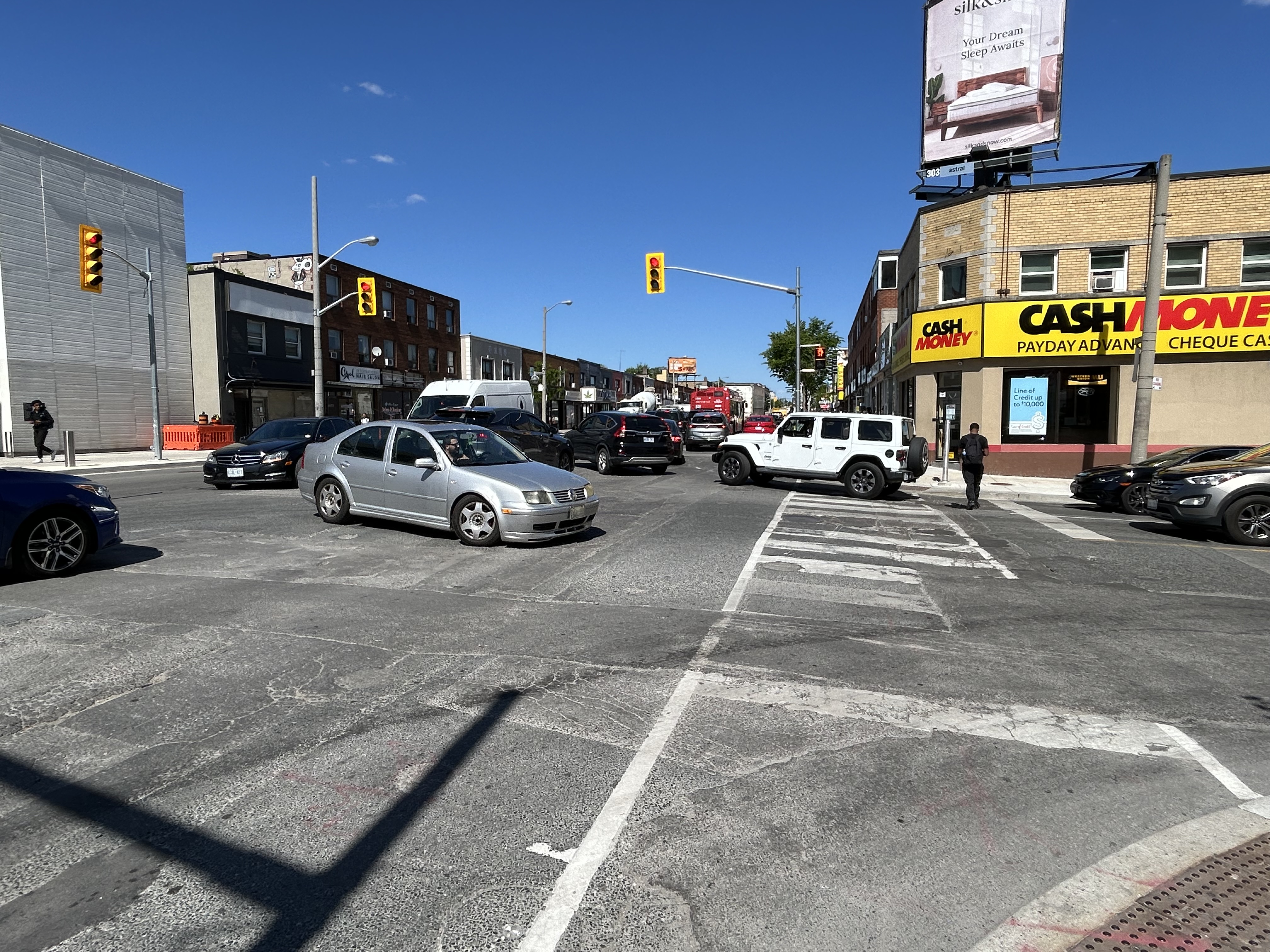
Despite the very unToronto urban intervention at Portland and Wellington, a very Toronto intervention continues one block north at King Street. Though the King Street Pilot was launched in November 2017, over eight years ago, little has been done since to improve the street for pedestrians or transit users. To discourage motorists from illegally proceeding through intersections (intended to eliminate congestion for streetcars and buses), the curb lanes are blocked with painted Jersey barriers. More recently, additional traffic lights were installed, so there are now signals for transit, cyclists, motorists, and pedestrians.
At Portland, and every other intersection that drivers are not permitted to go straight (taxi drivers are excepted after 10 pm), the traffic signals remain red at all times. A right green arrow appears for 5-10 seconds at the beginning of the cycle, allowing motorists to turn unimpeded. At Portland, however, eastbound motorists on King may not make a right on red because of the two-way cycle track on the west side of the street. Because of all these restrictions, there are seven signs facing eastbound drivers affixed to the traffic pole, along with two transit signals, one traffic signal, two bicycle signals, and one pedestrian signal.
This could have been clearer
The amount of clutter here can be confusing and is also unsightly. First off, there is no need for the “bicycle signal” sign below the two bicycle signal heads and next to the pedestrian signal. The signal aspects are already clearly for bicycles without the sign. Revising the Ontario Traffic Manual (OTM) to allow red arrows on traffic signals could both simplify the yellow traffic signal here and eliminate the need for the “no right turn on red” sign. It would also be clear then that right is the only permitted sign. Speaking of the OTM, dedicated transit signal aspects such as those used in Europe or even several American cities would eliminate the need for the “transit signal” sign and further reduce confusion. If the late night taxi exception was removed, the “no left turn” and “no straight movement” signs could be consolidated as well.
But most of all, the sign clutter makes it even more clear that the King Street Pilot configuration needs to become permanent, with raised curb extensions at the far sides of each intersection, with a level platform for streetcar boarding. Permanent planters and benches would be a visual cue to drivers that King Street is not a throughfare, but a pedestrian and transit-first corridor.
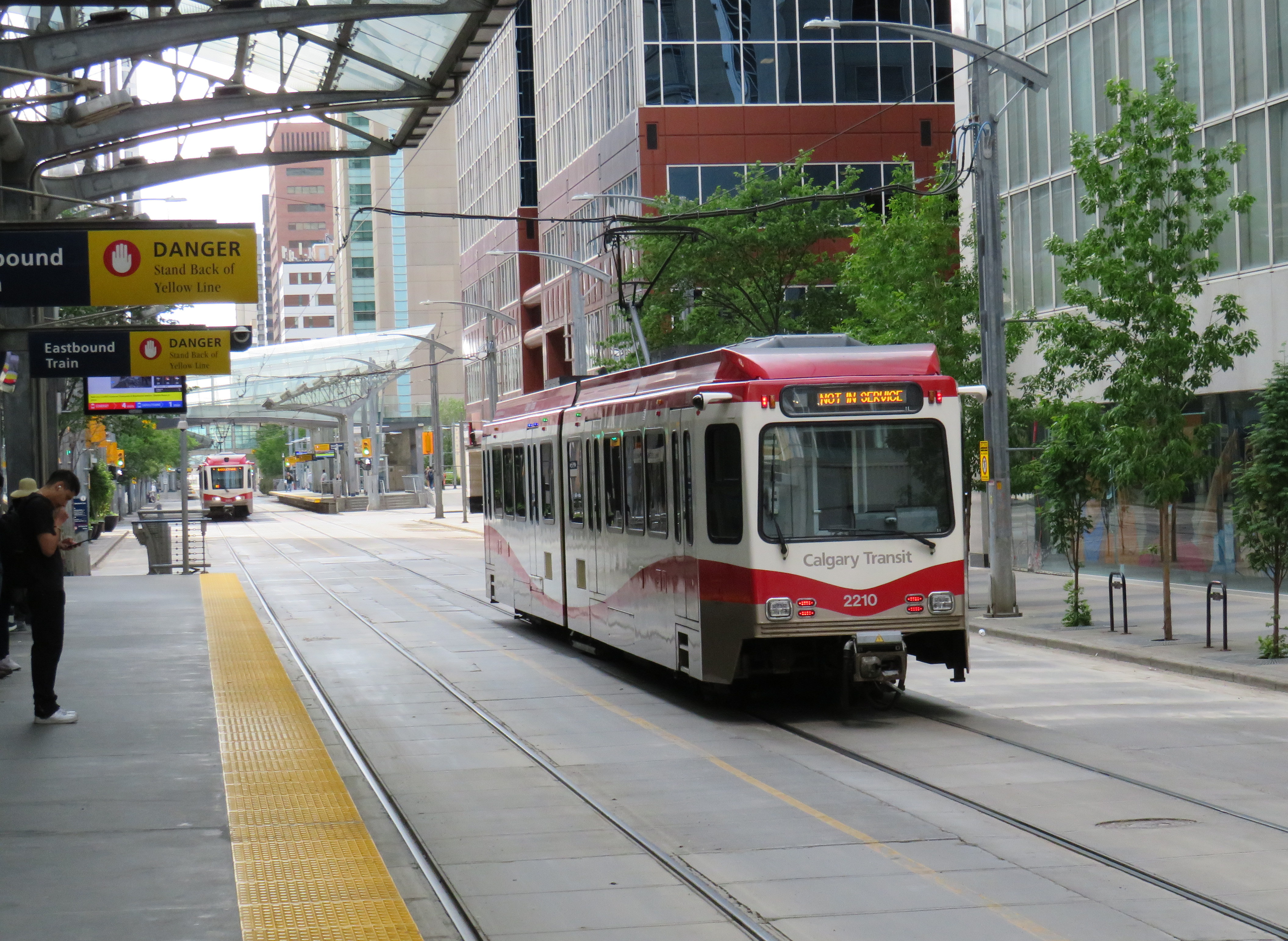
There is a lot less sign clutter along Seventh Avenue in Calgary, which is exclusively a transit and pedestrian corridor
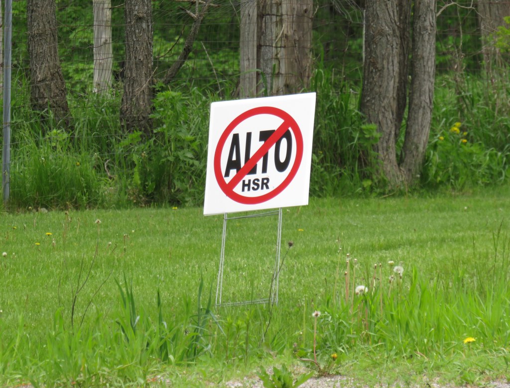
A “No ALTO HSR” sign on a property near Marmora, Ontario
There’s a running joke that Canada leads the world in high speed rail studies, but we never follow through with actually building those high speed lines. Comedian Rick Mercer had at least two sketches on his old weekly CBC television show mocking this state of affairs, as the idea goes back to the 1970s.
“VIA Rail: Yesterday’s speeds, today.”
“Canada’s High Speed Rail Study Industry: The future, never!”
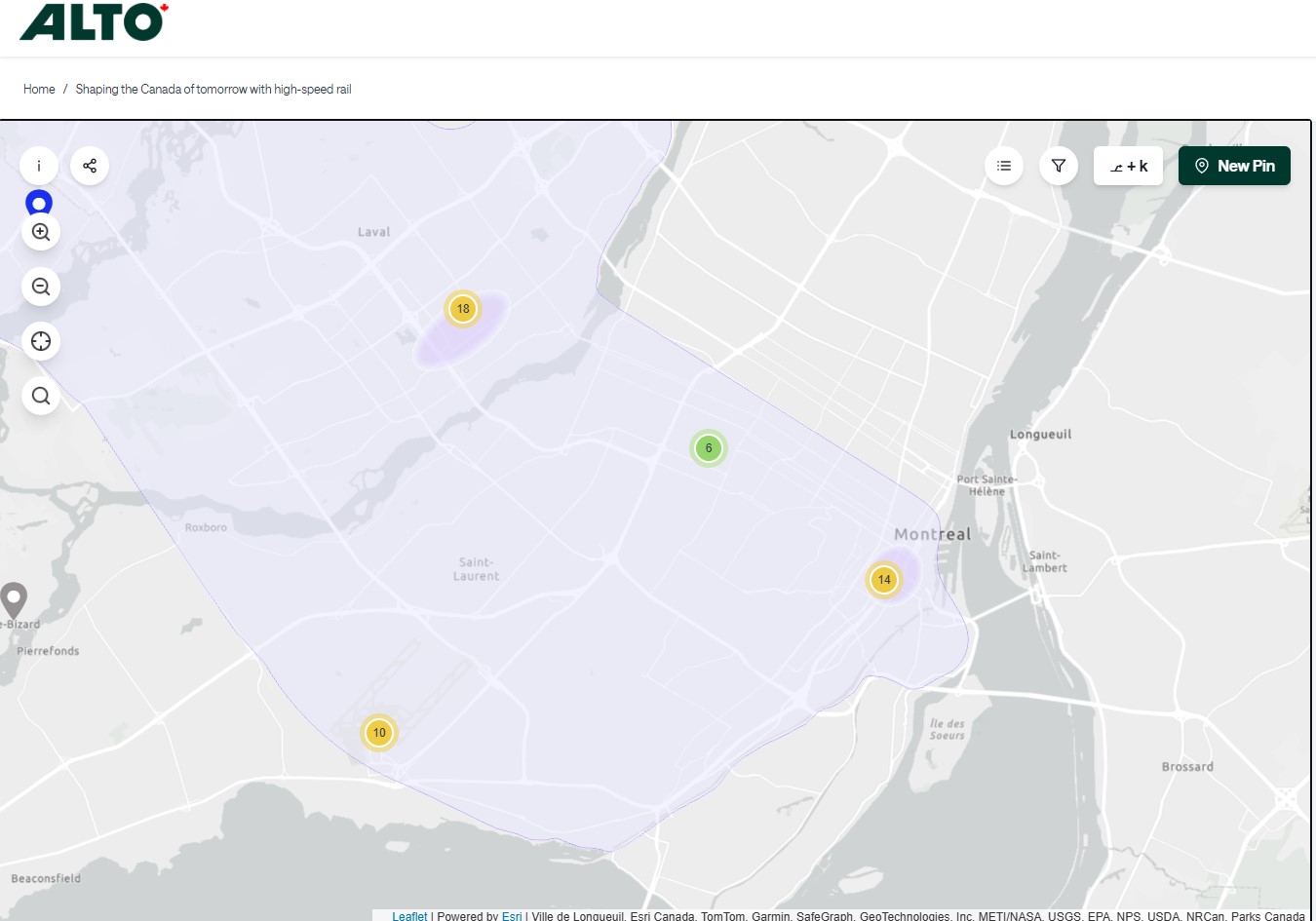
In 2026, however, Canada is finally past the high speed rail study phase and appears to be committed to building the seven-station corridor between Toronto, Ottawa, Montreal, and Quebec City, with a consortium selected that is already planning the detailed route. It’s an exciting time as the first phase, between Ottawa and Montreal, should start construction in three years once the exact corridor is decided upon and land acquisition has begun.
High speed rail, if done right, should benefit Eastern Canada as a whole. Fast and frequent train service will divert a lot of the travel in the busy Toronto-Montreal-Ottawa triangle from the air, reducing emissions and allowing existing airports to handle any increases in long-haul demand. Faster and more reliable passenger train service would also take traffic off the highways and boost commerce within the most populated part of the country. If done right, it will also support plans for better transport infrastructure outside the corridor to Southwestern Ontario and provide Canadian expertise for other projects such as in Alberta, which is contemplating its own passenger rail network between Calgary and Banff and north to Edmonton.
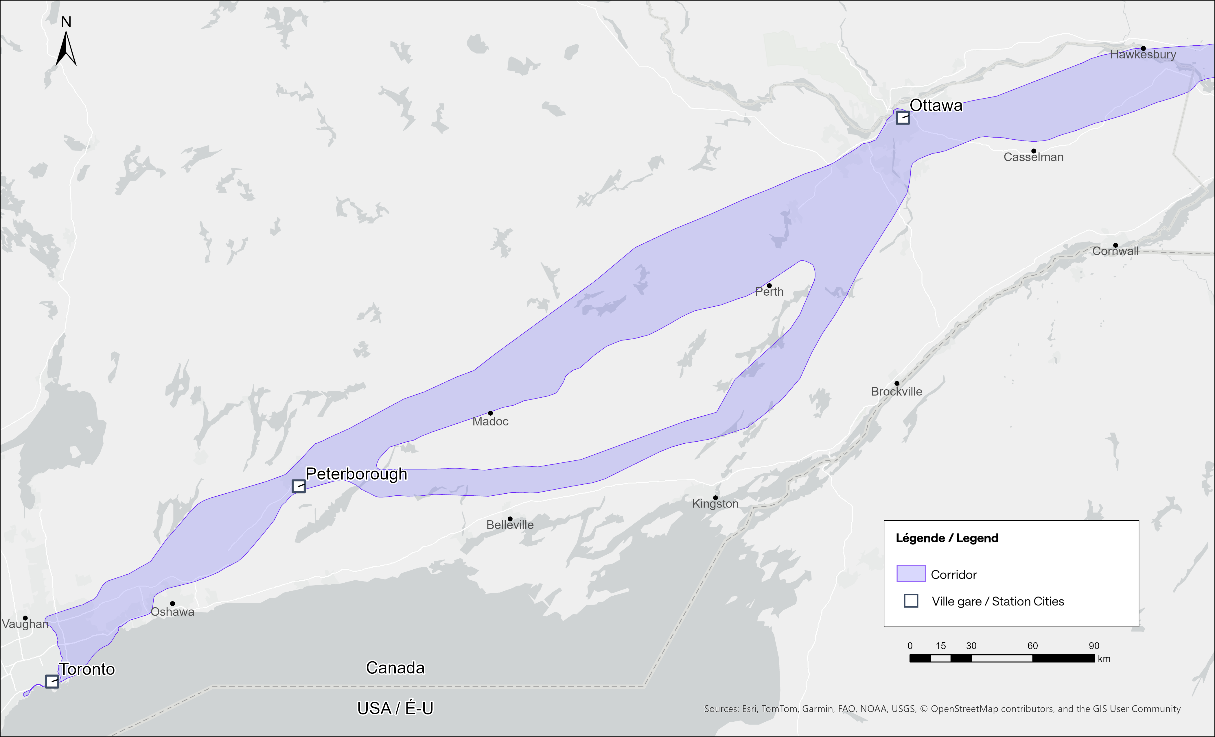
Map of potential routings for the Alto high speed line in Ontario
Not unexpectedly, there is opposition from residents and landowners along the route, especially in Eastern Ontario and the area of Quebec just northwest of Montreal. In Hastings County, north of Trenton and Belleville, there are a few dozen “No Alto HSR” signs on lawns and farms in places like Madoc, Marmora, Stirling, and Tweed. In this part of Ontario, between Peterborough and the Rideau Lakes region southwest of Ottawa, there are two broad potential routes: a southerly corridor runs near Campbellford, Stirling, Tweed, and Westport, including through some productive farmland in Northumberland and Hastings Counties. A second route runs north of Highway 7, just north of Madoc and Perth, along the southern fringes of the Canadian Shield.
Though a high speed railway line would be straight and relatively narrow, it would require the acquisition and severance of hundreds of properties. Along the existing CN and CP railway corridors to the south constructed in the 1850s and 1900s, there are frequent public road and private-access level crossings, something that is not possible with modern high speed trains passing at up to 300 kilometres per hour, so farmers whose land is crossed by the new high speed railway corridor may not be able to access parts of their property easily. Furthermore, there are no stops planned between Peterborough and Ottawa, a distance of over 250 kilometres.
In Prescott & Russell Counties in the Lower Ottawa Valley, even the local governments are opposed to Alto crews doing early survey work to determine an optimum route, with county warden Mario Zanth clear on the matter: “This council does not want them on our territory.” For now, Alto surveying is mostly done by way of drones over land where landowners have not granted access.
Once a more specific route is selected, hopefully some of the opposition will fade. Detailed design work and further consultation should also help mitigate concerns. This is especially important west of Ottawa, where there are the two diverging routes.
Despite the rural opposition, Alto should go ahead. Other major infrastructure projects, especially new highways, can be far more disruptive to local land use. But without local community benefits — at least a new freeway has regular access points — it will be harder to get buy-in.
Therefore, this needs to be a matter of “Alto and” than just “Alto” by itself. This means building and maintaining a supporting network of conventional VIA service, intercity and regional buses, and local transit connections. It might also mean adding a few additional stations along the route, in places such as Perth. Adding additional stops doesn’t have to slow down trains at all; Japan’s Shinkansen has three classes of trains, from the super-express Nozomi to the all-stops Kodama. While most passengers would be through Toronto-Ottawa-Montreal travellers, offering additional stops for select trains can make Alto more accessible to more people, especially if it means providing new options to underserved communities.
An express train passes the local Odawara Shinkansen Station in April 2019
If Alto becomes the backbone of a strong, integrated transportation network in Ontario and Quebec, the benefits will go far beyond those in the six cities directly served the planned high speed line, even to those directly bypassed by Alto trains. This integration is commonplace in Japan and Europe.
In Kingston, for example, a new or upgraded VIA station with additional tracks and platforms would allow for early morning departures and late evening arrivals from Toronto, Ottawa, and Montreal without having to sit on active CN freight tracks overnight; VIA schedules built around serving cities like Belleville, Kingston, and Drummondville would ensure the existing service remains vital as through passengers switch to the faster line. A new Kingston station near Division Street could integrate rail and bus services, with easy access to Highway 401, with local and regional buses to places like Gananoque. Enhanced bus connections to the rest of the Ottawa Valley from the Ottawa Alto/VIA Station could allow travelers from Pembroke, Arnprior, or Hawkesbury to quickly continue their journeys via train. At Trois-Rivières, there should be seamless connections to places like Shawinigan and Victoriaville. The Canada Intercity Transportation Map on this website shows which communities are unserved or underserved by bus and rail: these include many towns in Southern Ontario and Quebec that are within 100 kilometres of the Alto corridor.
Canada is right to invest in high quality and sustainable transportation infrasturure as a nation-building project, to boost the regional and national economy, and promote environmentally friendly travel options. But focusing only on Alto, without a strategy of leveraging the conventional VIA network and intercity bus connections to feed that network, can only limit the success of high speed rail. The communities in between deserve better.
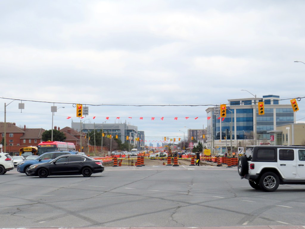
Hurontario Street, looking south from Steeles Avenue, where the first phase of the Hurontario LRT will terminate
The first phase of the Hurontario LRT, which will between Port Credit GO Station and Steeles Avenue in Brampton, is slowly taking shape after years of construction delays. In Spring 2026, eight years since construction started on the corridor, work on the LRT guideway into south Brampton has finally begun.
As I wrote in detail before, a previous iteration of Brampton City Council narrowly voted against the LRT entering downtown as a surface line in 2015. This was the version selected in the provincial environmental assessment. Instead, that council voted to study alternative corridors into Downtown Brampton requiring lengthy detours, and asking for the LRT northern terminus to be on the south side of Steeles Avenue, despite a major bus exchange — Brampton Gateway Terminal — on the north side of the intersection to accommodate all options. After the 2018 election, council recommitted to a Main Street alignment (though preferring a tunnel) and asked the province to restore the terminus on the north side of Steeles pending a decision on the final four kilometres into Downtown Brampton. In early 2026, only one of the six councillors opposed to the Main Street LRT ten years ago remains in office.
I wanted to follow up with Metrolinx to see how pedestrians would be safely accommodated at the Steeles and Hurontario intersection, given high traffic volumes, wide roads, and likely thousands of passengers switching between modes on a daily basis. Early concepts of an underground pedestrian tunnel were rejected by the province as out-of-scope, so pedestrians would have to cross both Hurontario and Steeles to make the transfer. Having no satisfactory answers despite many attempts to get an answer to this question, I took the lengthy and expensive route of submitting a freedom of information (FOI) request.
In summary, I learned that despite multiple requests from City of Brampton officials to restore the north side stop, Metrolinx and the provincial government refused. With the financial close with Mobilinx — the private-sector consortium selected to build, operate, and maintain the LRT — imminent in early 2019, there was no interest to make the minor change to facilitate the terminal, even though the city committed to taking on the cost on its own. The province was open to other changes to the line, however, as in 2022, it unilaterally renamed the line for a former Mississauga mayor and political ally of Doug Ford.
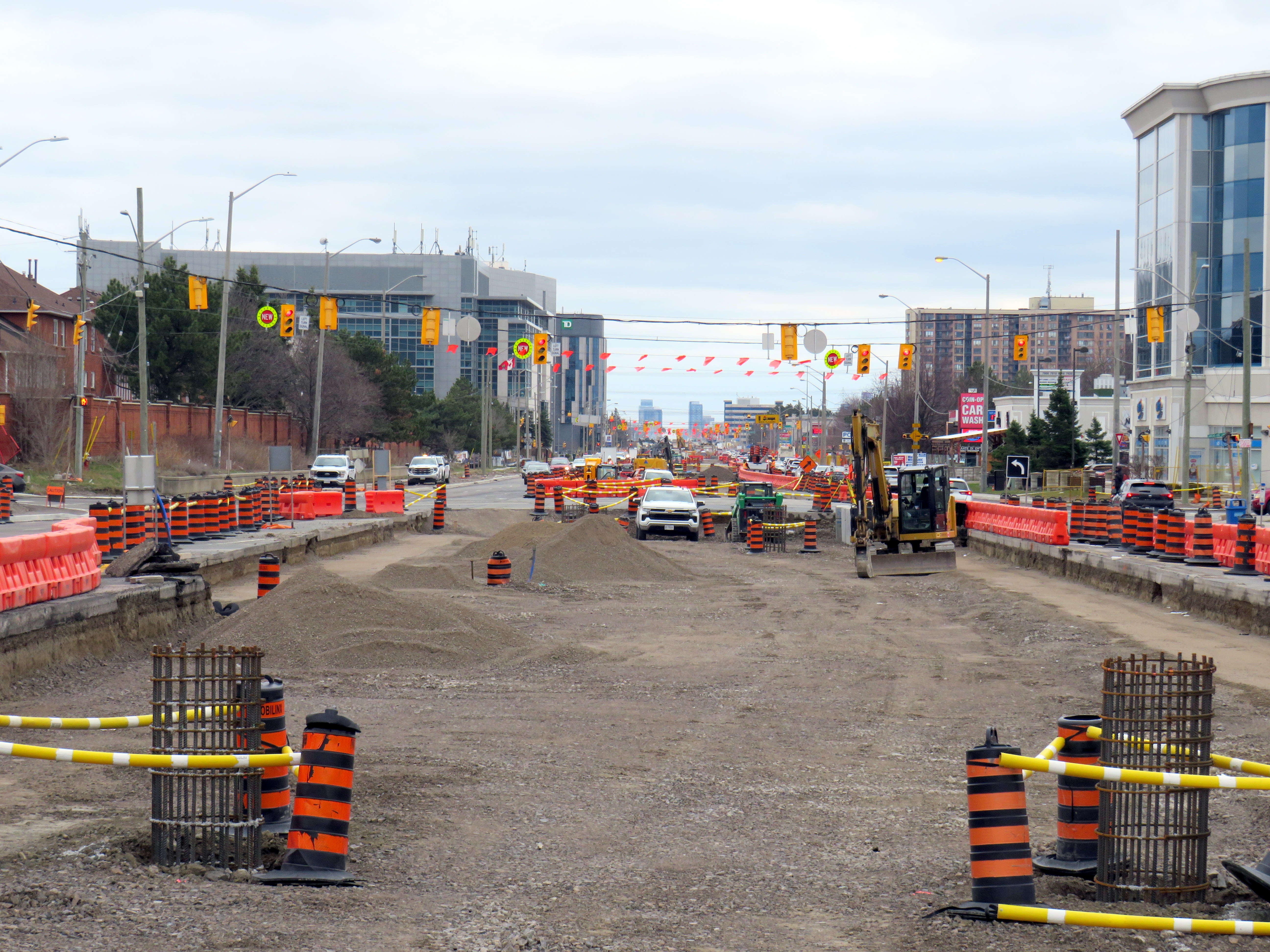
Looking south across Hurontario Street across a very busy multi-lane intersection towards the end of the LRT
As work at the Steeles-Hurontario intersection is now well underway, it has become visually clear the problem will be once the LRT opens. The population around the Brampton Gateway Terminal area is rapidly growing; a 40-storey condominium tower on nearby Steeles Avenue West is nearing completion, with many more highrise and mixed-use developments planned, including the eventual redevelopment of Shoppers World Mall. Already, there are dozens who cross nine-lane Steeles Avenue hourly; once passengers have to transfer from the LRT to the transit terminal on the northwest corner, there will be hundreds.
Furthermore, once the (now-funded) Phase 2 of the LRT to Downtown Brampton is started, the intersection will have to be torn up yet again to extend the tracks across Steeles and build a new north-side stop. The province’s refusal to do this all at once is baffling, and will likely be much more expensive than if it was done right the first time.
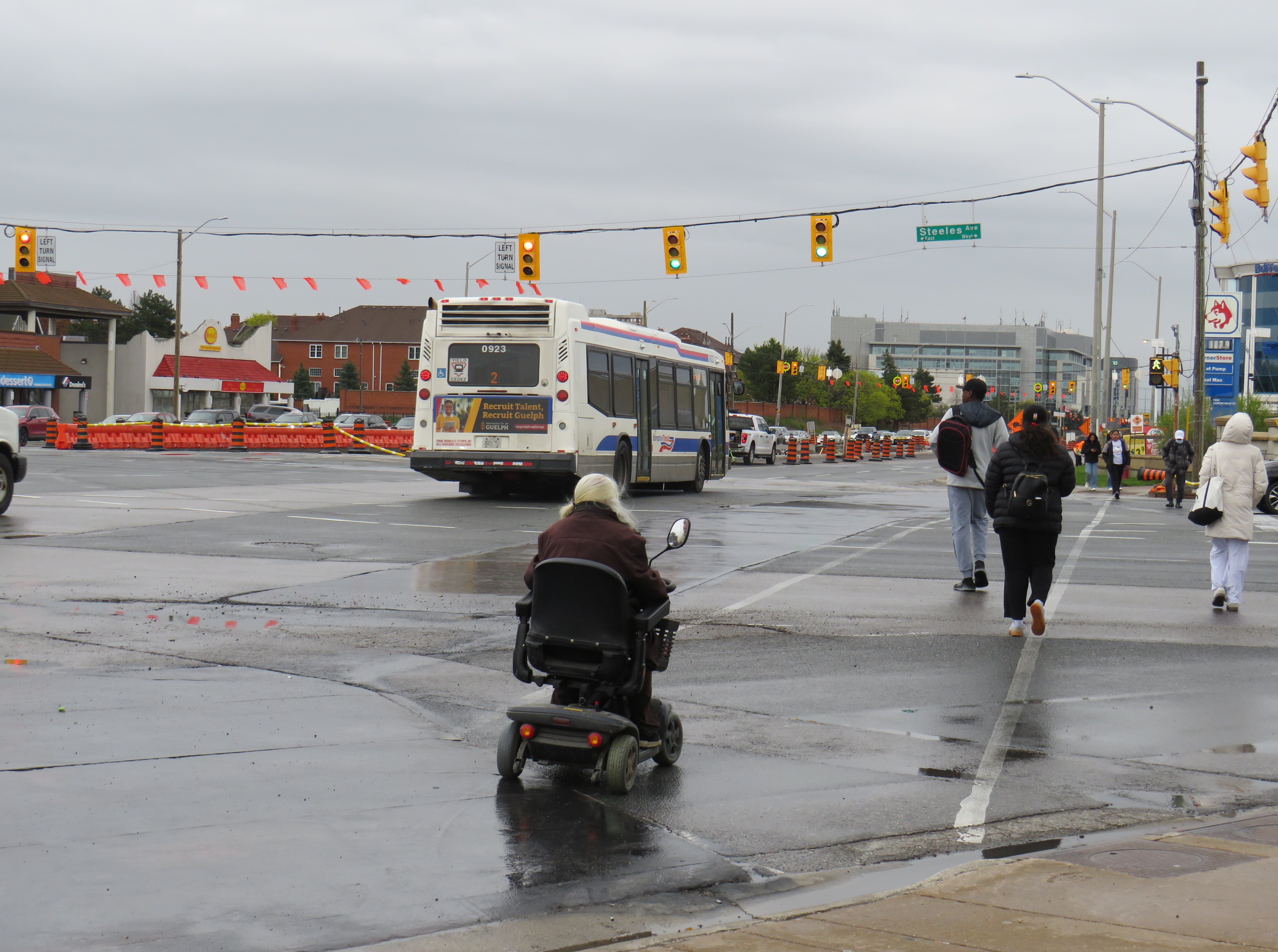
Looking across from Gateway Terminal towards the future LRT terminus on Wednesday, May 6. Already, there are plenty of pedestrians crossing here.
Already, the costs of the current Mobilinx contract have ballooned while construction delays pile up. The Hurontario LRT was originally supposed to open in 2024. In 2025, Mobilinx had to completely rebuild the track intersection at Topflight Drive just south of Highway 407 after track was already laid in 2023 due to construction errors. In February 2026, Global News reported that only 45 percent of the track was laid. Due to delays and problems paying contractors, the consortium’s credit rating was downgraded by Standard & Poor to BBB, which is near junk status.
Given the multiple delays and difficulties building the LRT, work is only now at the point where the dangerous terminal location is being baked in. Even though construction errors are fixed, and the project name changed, Metrolinx has been unwilling to address the safety issue at Steeles Avenue that was raised many times. In the meantime, Metrolinx, Peel Region, and City of Brampton will have to figure out how to mitigate the potential disaster that is now in the making.
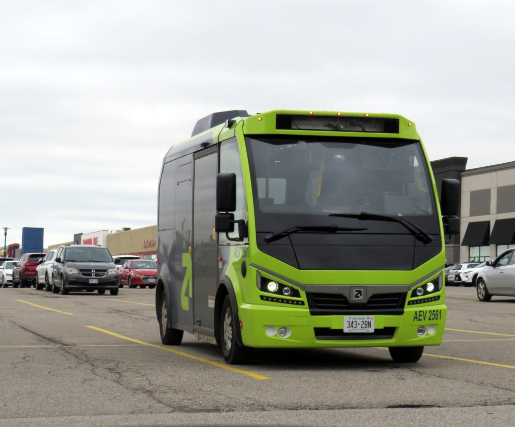
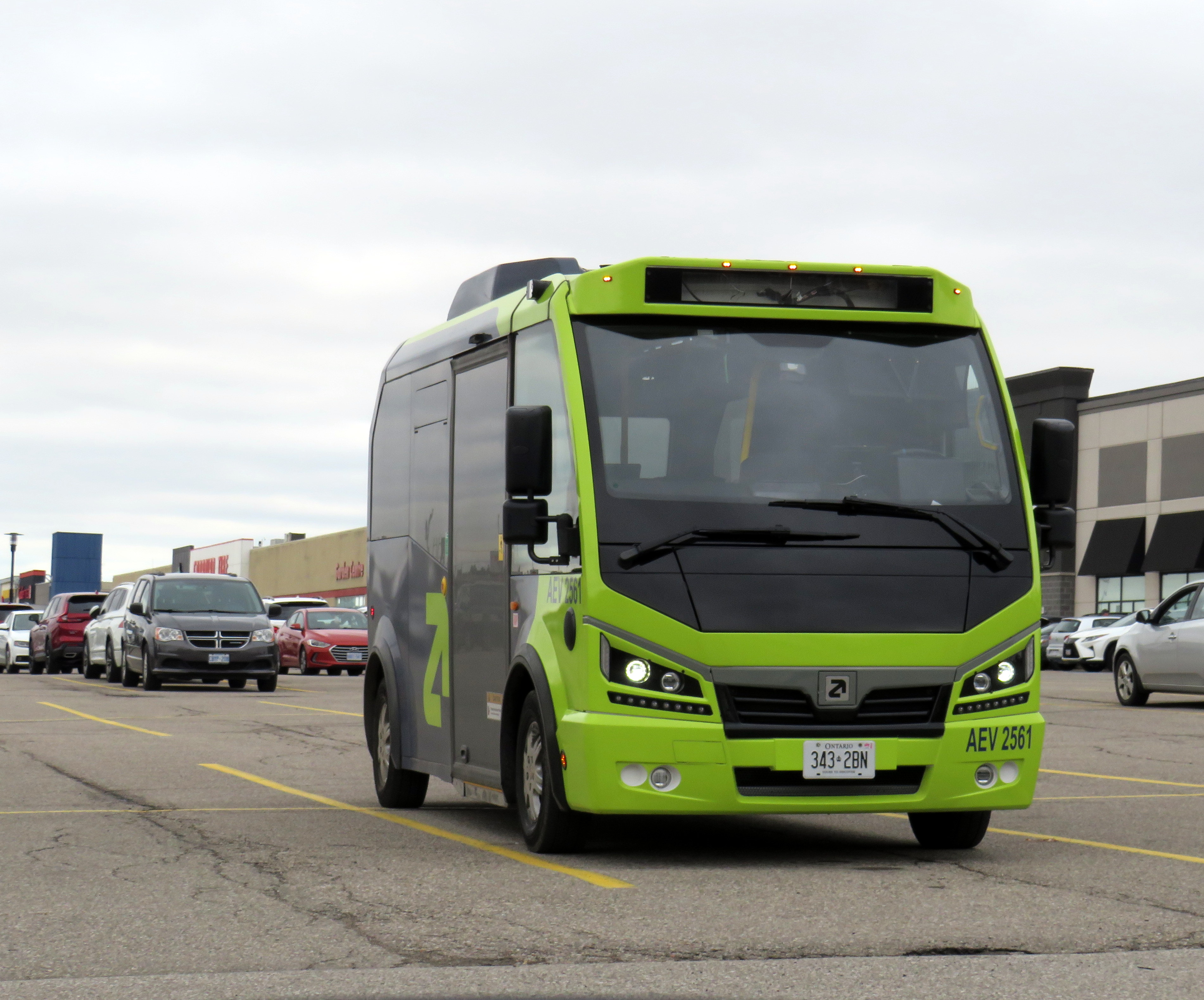
An Argo minibus lays over at Shoppers World Brampton
In an interesting staff report presented to Caledon Town Council, that municipality is planning to enter into a 15-month On-Demand Micro-Transit Pilot Agreement with Argo Transit, a Brampton-based provider of electric minibus services. This new on-demand transit service would replace most of the contracted Brampton Transit services in the Town of Caledon, including Routes 41, which serves Bolton, and 81, which runs along Kennedy Road north of Mayfield Road. Extensions of Route 30 Airport Road and 18 Dixie would continue under Brampton Transit, as they are limited-service extensions directly serving specific employers.
Argo already provides on-demand service in Bradford-West Gwillimbury, replacing a fixed-route service there last year It also operates a supplemental door-to-door on-demand service in central Brampton on top of the fixed route Brampton Transit service. In Brampton, and as expected in Caledon, the same fares at Brampton’s regular service are charged, paid through a Presto card or app.
The benefits for Caledon include new service to and within Caledon East, which is currently without transit, as well as midday, early evening, and weekend service not currently provided through Caledon’s contract with Brampton Transit. The proposed service times will be Monday to Friday from 5:30 AM to 8:00 PM, and Saturday and Sunday from 7:00 AM to 7:00 PM. If implemented, Argo service would begin October 1, 2026.
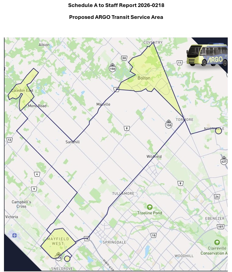
The map, included as an appendix to the staff report, shows connections to Brampton Transit on Mayfield Road and to York Region Transit in Kleinburg.
Map of proposed Argo service areas in Caledon, with connecting links.
There are some questions that should be addressed before October. Currently, Route 41 provides service to employment areas in south Bolton and provides connections to several Brampton Transit and YRT routes at Highway 50 and Queen Street, with easy transfers to the TTC subway in Vaughan and Humber College in Etobicoke. Would Brampton maintain a shortened route to Mayfield Road and Highway 50 that could make this link? Would transfers be permitted to other Brampton Transit routes along Mayfield Road, including Routes 15, 18, and 30, or would stops outside the on-demand areas be restricted to those in the map?
For Caledon, on-demand transit looks like an attractive option to replace Brampton Transit-contracted routes with low ridership and limited service hours. For it to succeed — and even build ridership for new fixed-route service in the future — connections to other transit will be necessary.
Despite population growth, Brampton Transit ridership is in decline
Meanwhile, Brampton Transit, after several years of dramatic ridership growth after the end of COVID-19 restrictions, is cutting back as ridership has taken a sudden dip in 2025-2026. Four minor routes — 33 Peter Robertson, 36 Gardenbrooke, 55 Elbern Markell and 56 Kingknoll — will be discontinued. These four neighbourbood routes provide local service in areas where other routes are within walking distance or operate in the opposite direction, so the effects are minor and the cuts justifiable if it keeps service going elsewhere.
However, Route 5 Bovaird, a major local route between Westwood Mall and Mount Pleasant GO Station, will see significant cuts: in the weekday peak from 13 minutes to 20 minutes and evenings from 30 to 40 minutes, and weekend evenings from every 30 to 50 minutes. The 505 Zum route that parallels the 5 does not operate weekend evenings, resulting in very poor service along the Bovaird corridor during those times.
This is a disappointing setback for transit in my hometown, which up to now has been a model for promoting ridership growth in a suburban edge city. For years, I have wrote about its success in growing demand by operating good service, especially to destinations well beyond its boundaries to places like York University (later the subway terminal in Vaughan), Mississauga City Centre, Humber College, and Pearson International Airport.
It would be very unfortunate if transit were allowed to enter a “death spiral” of ridership decline, fare hikes, and service cuts in response to this dip, largely due to a decline in international student enrollment at colleges and universities. Brampton has shown before that good service, with incremental growth is a great way of boosting ridership. This means operating buses at least every 20-30 minutes at all times on major corridors like Bovaird.
In 1998, the new City of Toronto was created when the Progressive Conservative government led by Mike Harris forced the merger of Metropolitan Toronto and its six constituent cities and borough. Dubbed the Megacity, it was part of a new round of municipal restructurings that affected much of the province, with Hamilton and Ottawa getting the same treatment three years later. Making less news in 1998 was the abolition of Kent County and the amalgamation of all 21 of its towns, villages and townships with the City of Chatham, creating the new municipality of Chatham-Kent.
Over 25 years later, there are challenges remaining from amalgamation. The new, larger municipality must administer a large mostly rural area but where nearly half the population lives in just one urban centre. But there are benefits, such as a consolidated library system that provides rural residents with more materials and services. Importantly too, is that Chatham-Kent was one of the first municipalities to introduce a rural transit service to connect outlying communities with the city centre, expanding the reach of Chatham’s existing urban bus system.
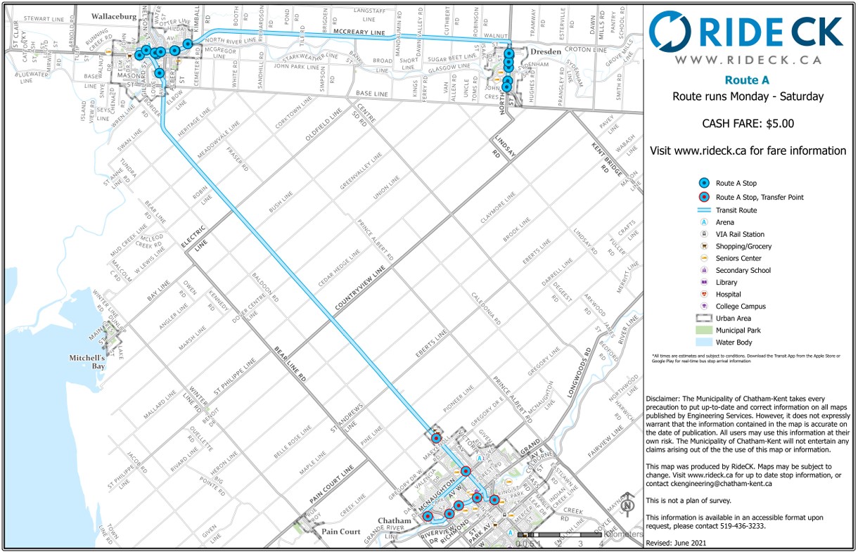
Three Ride CK routes — A, C, and D — extend from the bus terminal in Downtown Chatham to Wallaceburg (the second-largest community in Chatham-Kent), Dresden, Blenheim, Ridgetown, and Tilbury, covering most of the former towns that made up Kent County. (A fourth route, B, was proposed to serve Thamesville and Bothwell, but has not been implemented.) There is also a seasonal summer bus that serves the lakeside communities of Erieau and Mitchell’s Bay, echoing the former Chatham, Wallaceburg, and Lake Erie electric interurban service.
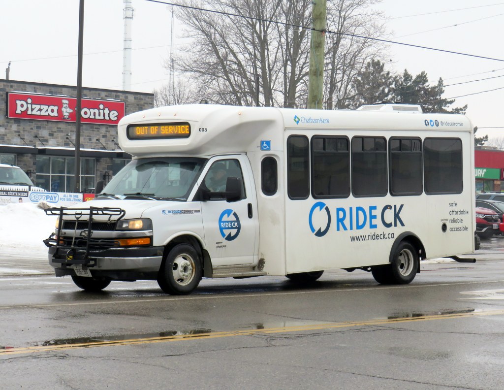
Most RideCK buses — local and intercommunity — are cutaways, meaning that the passenger seating area is in a separately-built body added to a cab and truck chassis. Though these vehicles are popular for paratransit services, low-ridership rural routes, and in smaller communities like Brockville, they do not offer a particularly smooth ride. However, they are an economical option for smaller communities.
Bus stop in Wallaceburg
Each of the three intercommunity routes operate Monday through Saturday, with two morning and two evening round trips, with an additional midday run that leaves Downtown Chatham at 12:15 PM on weekdays; this additional trip was added several years after service began. There is a timed transfer to the local Chatham routes, allowing for onward connections to shopping, schools, medical services, employment, or social activities. All three rural routes also stop at the hospital in Chatham. The midday trip was added to provide an early return home for anyone taking the bus from outlying areas, such as for a medical appointment, and not then stuck waiting an entire day in Chatham.
I rode RideCK between Chatham and Wallaceburg and back in early February 2026; the midday 12:15 departure had decent ridership with six other passengers leaving the bus terminal (a seventh got on at the big box retail cluster north of Chatham’s urban area); there were five other passengers on the way back south on the first evening bus (5:45 PM leaving Chatham). Given that Chatham-Kent has maintained the service for so long is indicative of how the rural buses are seen as a necessity in the municipality. In Wallaceburg, on-demand local transit is also available, a recent improvement by the municipality.
Intercommunity routes have a flat cash fare of $5.25 (though online materials still show the older $5 fare), though transfers to local transit are provided.
Ride CK Route A between Chatham, Wallaceburg, and Dresden
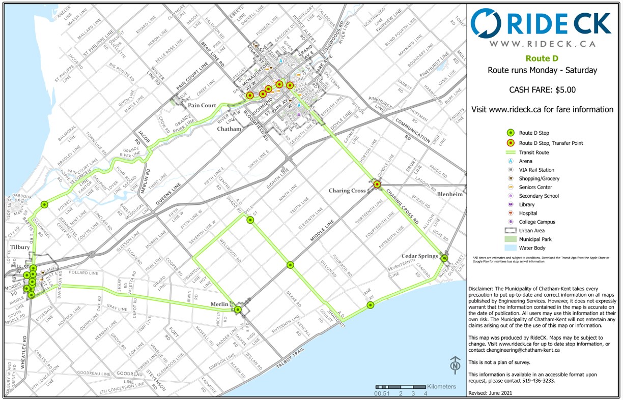
Though Routes A and C are fairly direct, Route D involves a long one-way loop to serve several small communities (including Cedar Springs, Buxton, and Merlin) before continuing to the former town of Tilbury and then back to Chatham. The route passes near, but does not stop at, Pain Court, and completely misses Wheatley.
The circuitous Ride CK Route D making a one-way loop through Cedar Springs and Tilbury
Though Chatham-Kent should be commended on identifying the need for rural transit and maintaining it for over two decades, it still demonstrates the challenges and gaps of operating a municipally provided rural transit service. Ideally, Chatham-Kent would be able to partner with neighbouring Lambton and Essex Counties to provide direct service to more communities. Tilbury should be part of an east-west service between Chatham and Windsor along the Highway 2 corridor, serving towns along Lake St. Clair such as Belle River. That would open connections to the University of Windsor and the main St. Clair College campus, along with other destinations, while improving service to Tilbury.
Route D, then, could be straightened and routed to serve Wheatley, even continuing west to make a connection to Leamington (which sadly, is losing its bus service to Windsor). With good scheduling, such connections could allow passengers to continue on VIA Rail service to London and Toronto.
Ontario needs a province-wide rural transit strategy with long-term funding and strong incentives to get reluctant municipalities (such as Halidmand County) on board. Until then, it is up to each local area to determine what, if any, transit service could look like, and up to residents to demand — and make use — of these services.
Unfortunately, the costs of maintaining this website and the ArcGIS Online portal to my maps continue to rise, especially as the amount of information provided and the number of views grow. If you enjoy my work and find the maps useful, please consider buying me a coffee to help with those costs. Thank you!
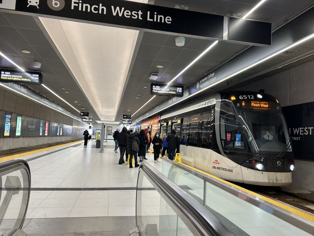
Interestingly, the 939B, which runs all the way from Kennedy Station to Finch West Station via Scarborough Centre, McCowan Road, and Finch Avenue, uses the York University Busway to get between Dufferin Street and Finch West Station. That busway, opened in 2009, was built to speed up travel times between the former subway terminus at Downsview Station (now called Sheppard West Station) and the university campus as the Line 1 extension to Vaughan was underway. When the Scarborough Busway opens — likely by the end of this year — it will use that exclusive transitway (also a temporary measure to speed buses along a subway project) as well.
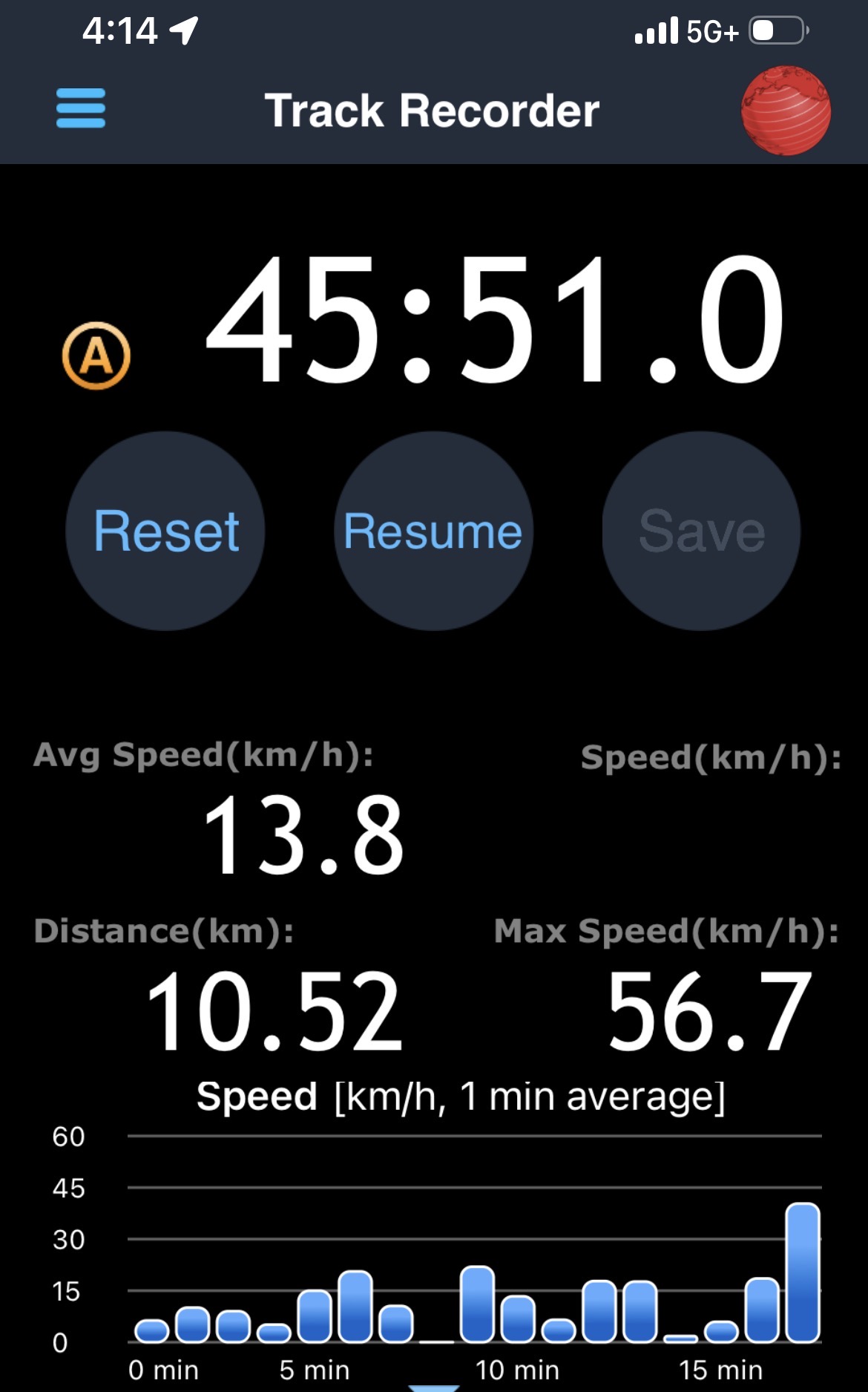
From Finch West Station, it took 44 minutes to ride to the other end at Humber College Station, 20 minutes faster than during a problematic ride back in December. The average speed was 14.1 km/h, with a short spurt of speed (up to 56 km/h) up the hill between Islington and Kipling Avenues.
Screenshot from a GPS app with the distance, average speed, and time it took to get from Humber College to Finch West Station
On the return trip, it took almost 46 minutes from Humber College to Finch West, less than 4 minutes faster than my last eastbound ride in December, and with an average speed of 13.8 km/h. The eastbound train I was riding managed to arrive at Kipling Avenue (Mount Olive Station) just as the LRT signals were turning from amber to red (motor traffic still had 10 seconds of green light), followed by the stop at the far-side station there. The train also managed to arrive at Islington Avenue as the LRT signal was turning red, resulting in another long wait. At each intersection, the trains crawled at 15-20 km/h as parallel traffic sped by, and the Alstom Citadis cars were noticeably rough riding. The section between Humber College Station and Westmore Drive is especially painful, with LRV cars making the turn at 7-8 km/h.
On Eglinton Avenue east, the two-car Bombardier Flexity trams manage to glide through at-grade intersections at a less frustrating speed, and they noticeably provide a lighter, quieter ride.
On the positive side, station dwell times on Line 6 were noticeably reduced, and it seems that operations are a bit more consistent after two months of operation; there were no notable gaps between LRV cars. However, there are still issues to be worked out, as Friday, February 27 saw more switch problems that closed part of the line for several hours.
Hopefully, further operational improvements and signal priority follow, and the signal and track issues get sorted out. I’ll return later in March for another ride to see if the ride improves further. I worry, though, about the Citadis LRVs, as they are looking more and more like a defective product that may not be redeemable.
On Sunday, February 8 the Eglinton-Crosstown LRT opened to the public without any pomp or circumstance. Perhaps embarrassed by the public’s reaction to Line 6 Finch West, there were no giveaways, no parties, and no promotional materials. That turned out to be a shame, in a way, because Line 5 seems to be alright so far, a week after its initial opening. Travel times on the LRT are improved over the previous 32 and 34 bus routes, though with lesser speed improvements on the surface section versus the western portion. The two-car Bombardier Flexity trains do not crawl through intersections on Eglinton Avenue East unlike the single-car Alstom Citadis Spirits on Finch Avenue West.
Furthermore, learning some lessons from the botched Line 6 launch, the TTC — the operator of Line 5 trains — is looking for public feedback and promises improvements to speed and frequencies later in 2026. There are certainly ways in which this line can improve further. All that said, the Eglinton-Crosstown LRT offers needed optimism for Toronto’s transit future, especially as more projects are underway.
Mostly smooth operation of Line 5 during the first week(more…)
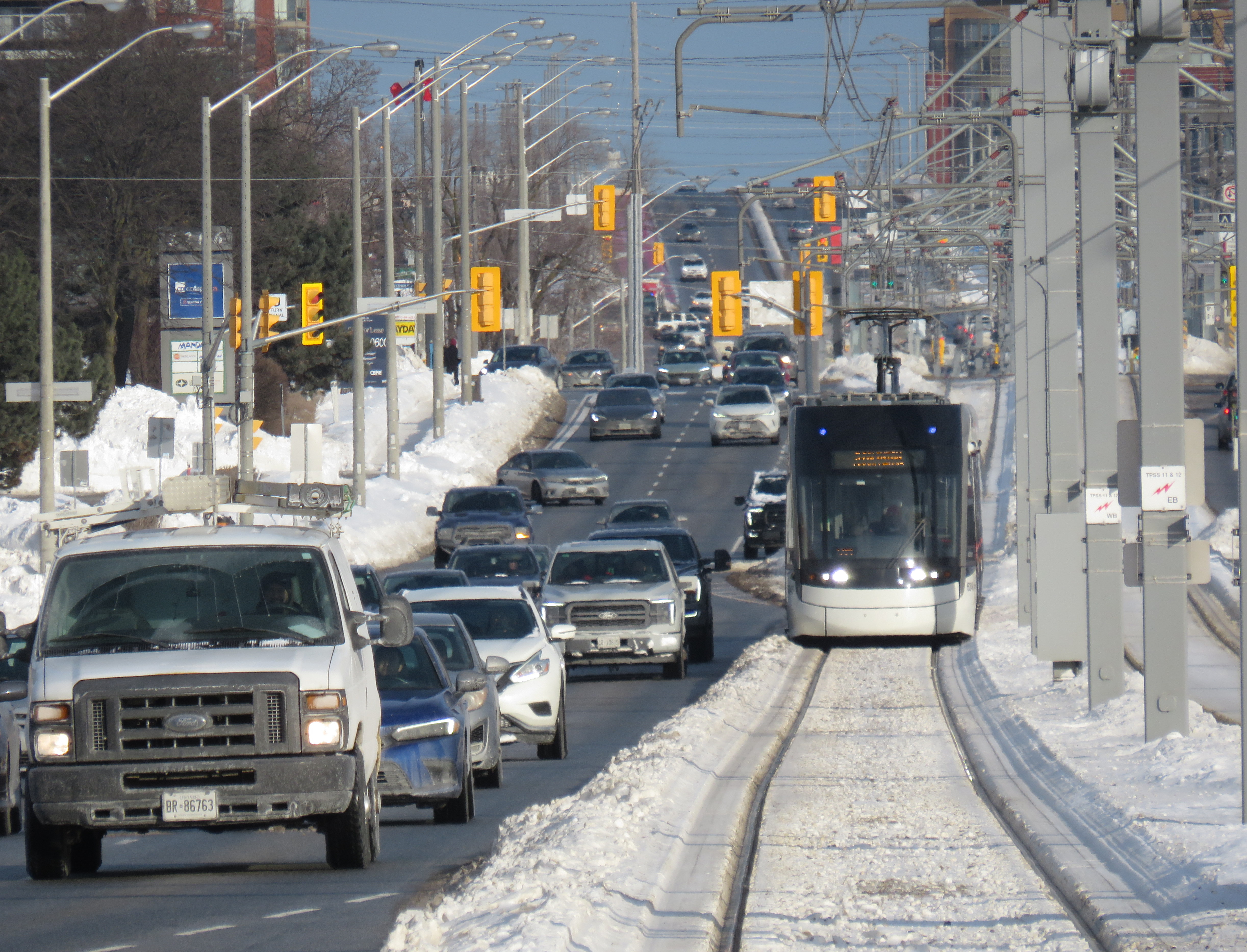
A westbound LRV train on Eglinton Avenue in Scarborough, January 2026
After fifteen long years, the wait is over. On Sunday, February 8, the Eglinton-Crosstown LRT will finally open to the public, with the first train leaving Kennedy Station at 7:00 AM. (The first eastbound train will depart Mount Dennis at 7:07 AM.) Rides will be free on that first day, but there will be no opening celebration, no ribbon cutting, and no giveaways. At first, trains will run until 11 PM, with Line 5 shuttle buses from 10 PM until 1AM, when the 334 night bus takes over.
After the botched opening of Line 6 Finch West, it is clear that no one in charge wants to celebrate the opening of this new transit line after years of construction delays and false hope of completion in 2020, 2021, 2022, 2023, 2024 and 2025. So if you want to check out Toronto’s new ride, go do it at your own convenience. You won’t miss anything.
There will be no party, like the one arranged last December at Finch West
But even if the trains run slower than originally planned at first, there should be a ramping up of speeds and transit priority in the surface-running eastern section. The tunneled section will have speeds up to 60 km/h between stations, making it considerably faster than the buses it will replace. During a visit to Scarborough last month, it already seemed that trains were running a bit faster in the outdoor section than on Finch West, so there’s definitely some reason to welcome the LRT in its initial “soft opening” phase.
The TTC notes that once full service is operational later in 2026, the end‑to‑end travel times will be “approximately 50–55 minutes.” That’s about twice as fast as the bus when going all the way from Mount Dennis to Kennedy. Perhaps, once the trains are running on a full schedule until 1AM and with expected performance improvements, there will be a formal ceremony to conclude this long journey.
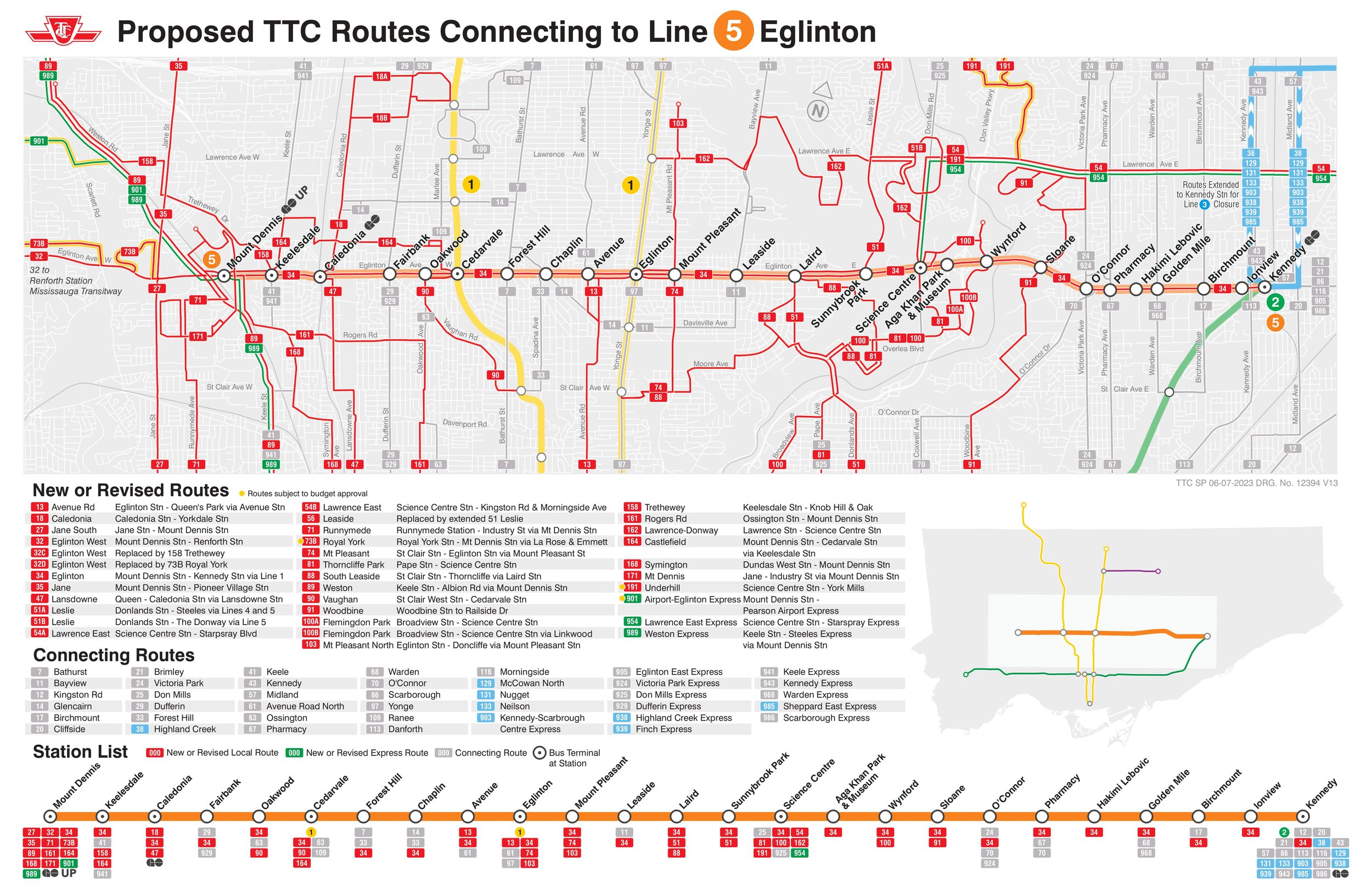
Notably on Sunday February 8, there will be significant changes to the bus network, including 2 discontinued routes, 13 route changes, and 4 new routes. Most notably, Routes 54 and 954 on Lawrence Avenue East will now terminate at Don Valley Station instead of at the subway at Eglinton Station. Route 35 Jane will no longer continue south of Weston Road, but will instead terminate at Mount Dennis (with new Route 27 Jane South taking over that southern section). The 47 Lansdowne will be split into two, with 18 Caledonia providing service north of Eglinton. Routes 51 Leslie and 56 Leaside will be merged (with a short 151 Leslie North bus on the north end), and the 32C branch will be replaced with the new 158 Trethewey bus. The map below shows how the TTC buses will connect with Line 5. (Route 901, between Mount Dennis Station and Pearson Airport via Dixon Road, has not yet been approved.)
Map showing TTC bus route changes; several of these were already implemented in late 2025. Only the 901 express route to Pearson Airport has not been approved.
I will certainly make time to check out Line 5 on Sunday, followed by a more fulsome review a week or two after opening to form an honest and thoughtful opinion.
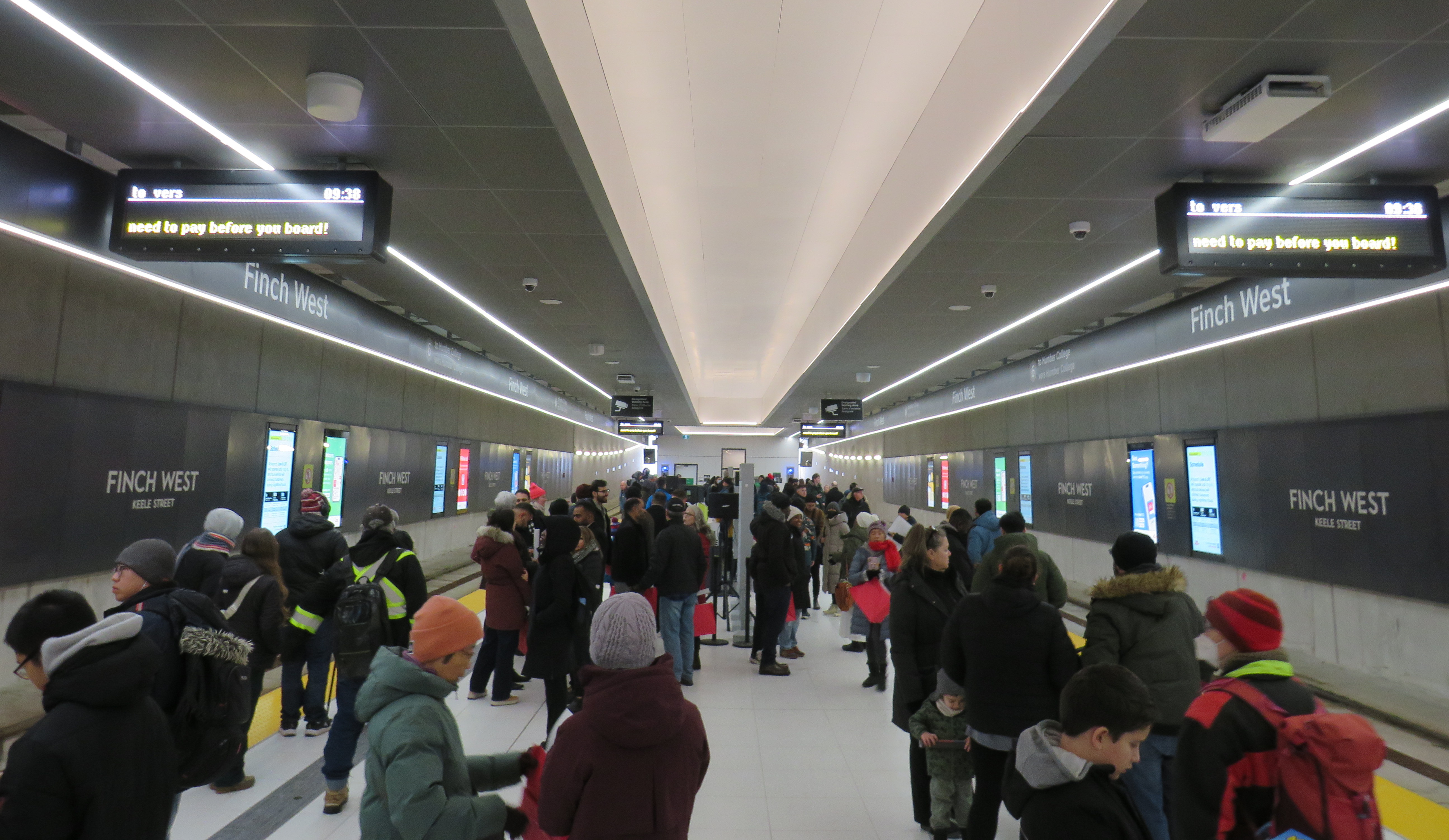
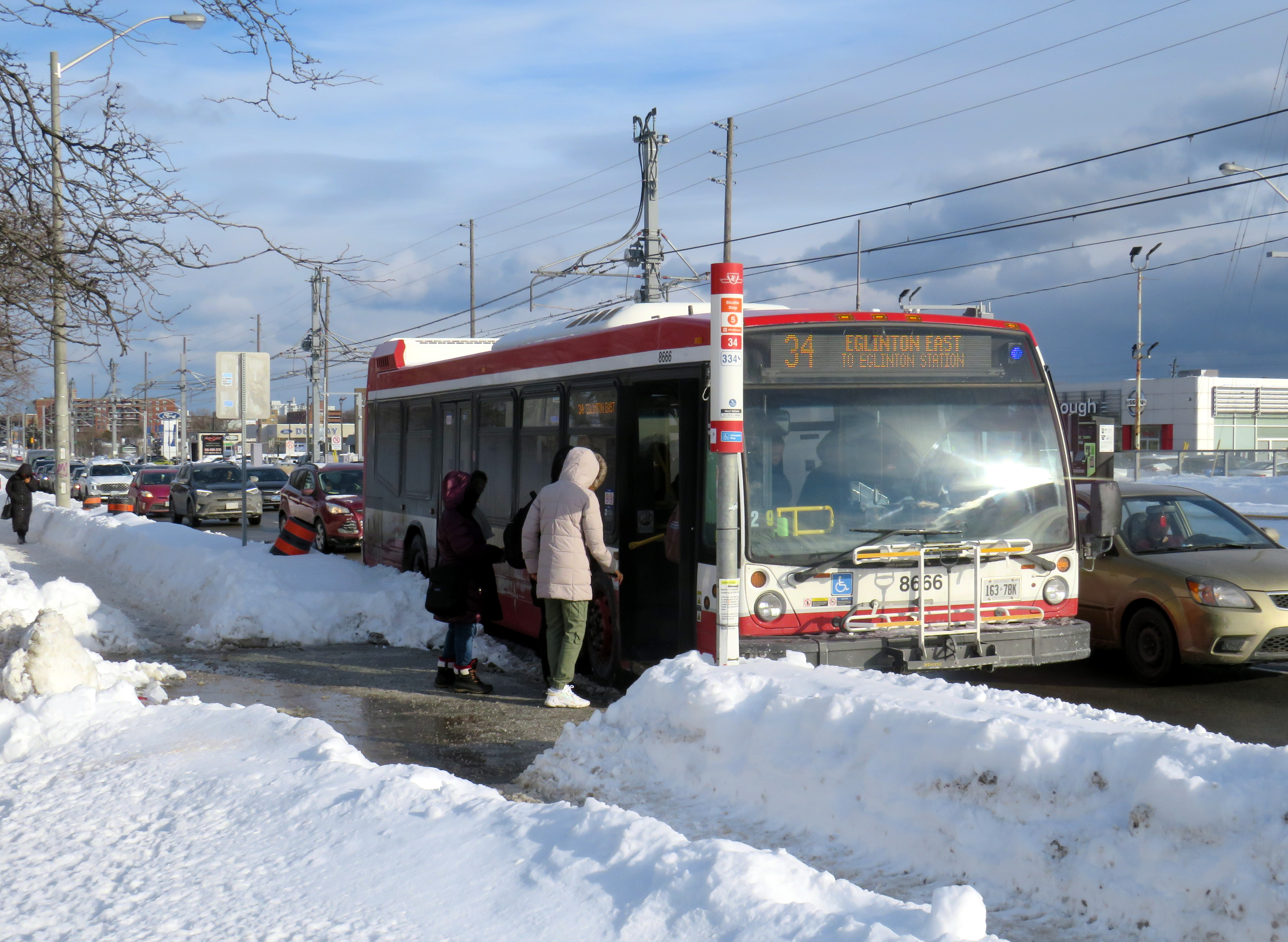
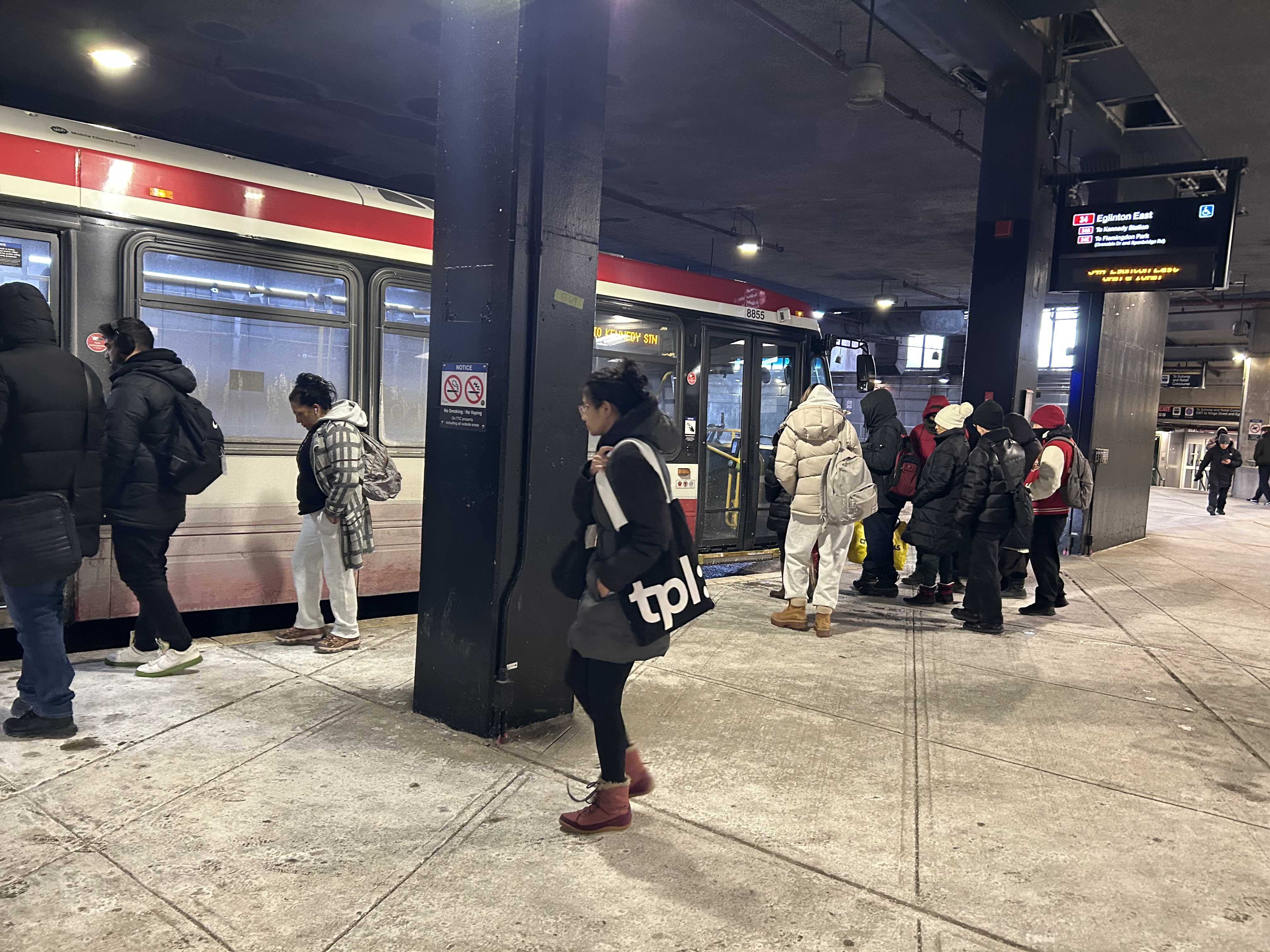
Passengers boarding the 34 Eglinton East bus, January 28, 2026
On Sunday, February 8, the long-awaited (and long-delayed) Line 5 Crosstown LRT will finally open to the public (or maybe not). The new line, 19 kilometres long with 25 stops, is nearly twice as long as the 11-kilometre Finch West LRT that opened in December.
Unlike the troubled Finch West LRT, the Eglinton-Crosstown line is largely underground, with twelve stations, from Mount Dennis to Laird, completely separated from road traffic. A western extension through central Etobicoke to the Mississauga border at Renforth will also be completely grade-separated. There are several other major differences: the Crosstown line will be more frequent than Finch West, and will have more capacity, with two-car trains operating at all times. The equipment will be different too: Bombardier Flexity cars, the same as those used in Kitchener-Waterloo, will make the up the trains. Furthermore, the underground section will be computer controlled (which might turn out to be a complication, rather than an advantage).
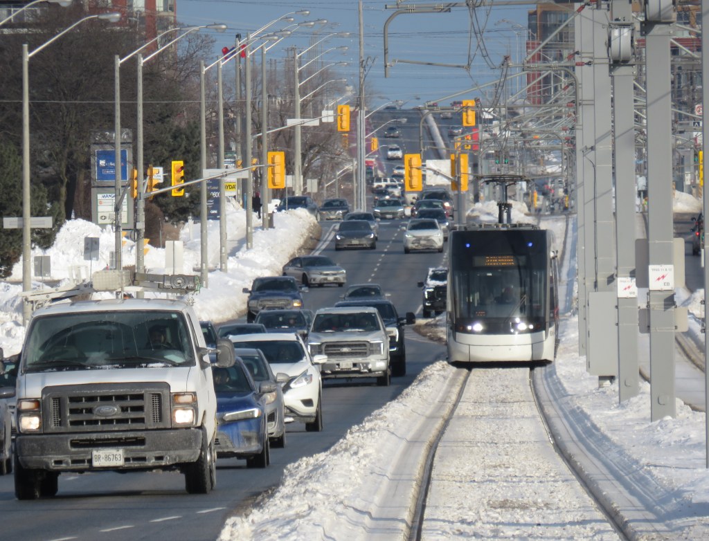
A light rail train passes traffic on Eglinton Avenue East in Scarborough
However, some aspects will be the same. The surface-running eastern section between Leslie Street and Kennedy Road will feature 10 outdoor stops and 16 traffic signals, though the LRT will dip below ground at Don Mills Road (formerly Science Centre Station, now Don Valley Station) and under Kennedy Road into the Kennedy Station transit hub. As with Finch West, this was a Metrolinx-led project with a private consortium in charge of construction and maintenance, with the TTC in charge of train operations. So it will be interesting to see how Line 5 fares.
With subway, light rail, buses, and GO trains, Kennedy Station is becoming a proper transit hub
In the meantime, just as with my visits to Finch West, I decided to see how long it takes to get across the LRT corridor. In May 2024, I walked the entire route over three days, getting to know the corridor better (while documenting my stroll on a social media platform that I have since abandoned). With rumours of a mid-winter 2026 opening, I decided to ride the buses to get further context and time the rides.
Congestion at Eglinton Avenue West and Oakwood Avenue, May 2024
Tuesday, January 20 was an ideal day to ride the 32 Eglinton West and 34 Eglinton East buses. That was several days after the last snowfall (and a few days before the next big dump), and the roads and sidewalks were completely clear. It was a bright, sunny (albeit cold) day, and there was only one short construction zone on Eglinton Avenue, near Caledonia Road. Though only a small number of riders would use the entire Crosstown LRT line as part of a regular commute, it was worth getting a sense of how long the trip would take between each station.
I started at Kennedy Station after taking a Stouffville Line GO train one stop from Union Station, rode the 34 Eglinton East bus all the way to Eglinton Station at Yonge Street, and then after a break (including a stop at Cinnabon), continued west to Mount Dennis Station, which is already open to GO and UP Express trains, as well as a few TTC routes. The last half of the ride coincided with high school dismissal times that resulted in some crowding, especially between Avenue Road and Dufferin Street.
From Mount Dennis, I returned eastbound during a busy weekday afternoon rush hour, transferring to the first available 34 Eglinton East bus at Eglinton Station all the way back to Kennedy.
Waiting for the 34 Eglinton East bus to Kennedy Station, January 20, 2026
The table below shows the timings at each LRT stop.
Westbound (read down)
Stop/Station
Eastbound (read up)
1:28 PM dep.
Kennedy
5:35 PM arr.
1:32
Ionview
5:30
1:34
Birchmount
5:28
1:37
Warden Ave. (Golden Mile)
5:24
1:39
Hakimi Lebovic
5:22
1:42
Pharmacy
5:20
1:43
Victoria Park Ave. (O’Connor)
5:18
1:46
Bermondsey
5:15
1:49
Wynford
5:08
1:51
Don Mills Rd. (Don Valley)
5:01
1:53
Leslie St. (Sunnybrook Park)
4:58
1:57
Laird
4:50
2:00
Bayview Ave. (Leaside)
4:48
2:04
Mount Pleasant
4:44
2:10 PM arr. 2:47 PM dep.*
Eglinton Station (Bus transfer)
4:39 PM dep. 4:32 PM arr.***
2:52
Avenue Road
4:25
2:54
Chaplin
4:19
2:58
Bathurst St. (Forest Hill)
4:15
3:03
Cedarvale Stn.
4:09
3:07
Oakwood
3:56
3:11
Dufferin St. (Fairbank)
3:51
3:18
Caledonia**
3:44
3:21
Keele St. (Keelesdale)
3:41
3:25
Mount Dennis
3:37 PM
87 minutes
Total ride time (inc. a 7 min transfer at Eglinton Stn.)
118 minutes
* This gap provided an opportunity to use the washroom, and get a coffee and snack ** Time noted at Blackthorn Ave, the closest stop to the LRT station entrance *** Took first 34A bus to Kennedy Station that departed Eglinton after my arrival; a 34C bus to Wynford Dr. and Flemingdon Park departed first
On the surface buses, the most significant traffic delays are near the Don Valley Parkway and Allen Road, especially eastbound between Oakwood Avenue and Cedarvale Station and between Don Mills Road and Bermondsey Avenue. For anyone crossing Yonge Street, the transfer between buses takes on average seven minutes including walking and waiting time.
Line 5, the Eglinton Crosstown LRT, will run deep below the Line 1 University Subway at Cedarvale Station
The dedicated right of way should allow transit riders to get ahead of traffic congestion, especially around Allen Road, where the trains will run in a deep bore tunnel. In theory, the median right-of-way will help get passengers past congestion near the DVP and the big box retail in the Golden Mile, but if the trams are as slow through intersections as on Finch and held up by red lights, the advantage here will be minimal.
At Eglinton and Warden, I did see a traffic signal hold a green light a few extra seconds to allow a train to pass through before changing, so that was a positive sign. But watching the trains go by every few minutes, I noted that the transit priority system was not at all aggressive, and as on Finch, transit signals turn red 12 seconds before the general traffic signals do.
On January 28, Eglinton and Warden, the transit signals stayed green for a short extra time to allow the non-revenue LRT train to pass through and stop at the far-side platform. The train was moving at a more reasonable clip too.
The Eglinton Crosstown LRT, unlike Finch West, serves a regional need that requires better speeds and more capacity than a mere surface tram, especially as it will have many bus routes directly feeding into it, rather than just intersecting. Several bus routes that used to continue into Eglinton Station, such as 54 Lawrence East, will instead terminate at Don Valley (formerly Science Centre) Station, where riders going west to the subway will have to transfer. For inexplicable reasons, the short section between Don Mills Road and Laird will have one at-grade station with a signalized intersection, a weak link in what will likely be a very busy section of the line.
Map of planned changes to TTC bus routes with Line 5’s opening. Some of the changes, including the introduction of Route 164 Castlefield and the extensions of routes 79, 161, and 168 to Mount Dennis Station have already been implemented.
Hopefully, some of the lessons from the Line 6 opening will be applied to Eglinton before it opens. There should also be an opportunity, just as there is on Finch, to make further changes to operations where applicable during a “soft opening” period. But we can not afford yet another botched transit project, especially after 15 years of waiting.
With planning now well underway for the Alto high speed passenger rail corridor between Quebec City and Toronto, there has been some speculation that Ottawa’s grand old Union Station, in the heart of the capital’s downtown core and a mere stone’s throw from Parliament Hill, could see trains again. Local business leaders and Mayor Mark Sutcliffe are excited by the idea of a downtown station, expecting that a downtown transport hub would help revitalize the local economy. Though it’s a very attractive idea, there are unfortunately just too many reasons why this would not be feasible.
To understand why, it’s worth diving into the history and urban politics of railways in the National Capital Region.
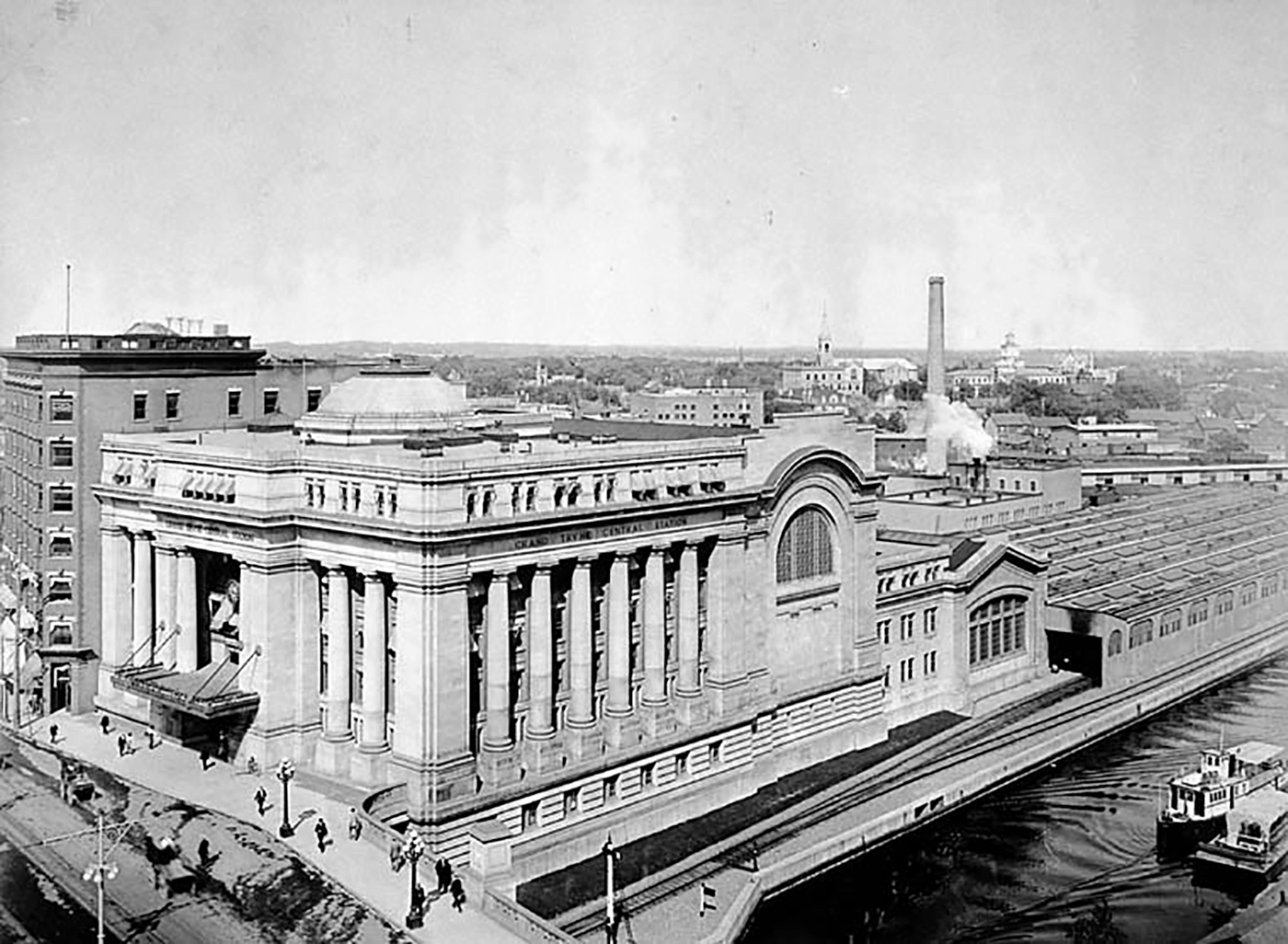
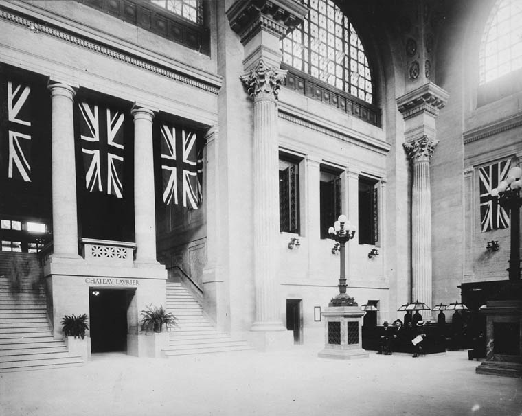
The Grand Trunk Central Station, opened in 1912, provided a grand entrance to Canada’s capital city that was previously served by a few smaller stations just outside the downtown core. The station, designed in the Beaux-Arts style, was built as a stub-end terminal. This meant that trains would arrive and depart from the south and would have to be backed up to change direction. This suited the Grand Trunk Railway just fine, as it lined up perfectly with its route to Montréal via Alexandria (still used by VIA Rail today). The railway also built a hotel across the street — the Chateau Laurier — and connected the station with the hotel with a pedestrian tunnel.
Entrance lobby, soon after opening. Note the tunnel under the staircase to the Chateau Laurier. (Library & Archives Canada)
The 1912 station was intermodal from the very beginning. Right outside the station’s front doors, there were Ottawa Electric Railway streetcar platforms serving several routes on Rideau and Sparks Streets, the two main commercial corridors in Downtown Ottawa. Right below the canal and railway bridge next to the station was the Hull Electric Railway’s loop; its streetcars crossed into Ontario via the Alexandra Bridge.
The Alexandra Bridge carried CPR trains, Hull streetcars, pedestrians, and motor vehicles when it opened in 1901
Soon after opening, the Canadian Pacific Railway joined the Grand Trunk, resulting in the terminal being renamed Union Station; the short-lived Canadian Northern Railway (CNoR) soon followed. As the CPR’s tracks to Hull (via the Alexandra Bridge) ran next to the GTR’s station, it suited the CPR well. Unlike Grand Trunk, both the CPR and CNoR had direct lines to Toronto.
Two platforms on the west side of the station allowed through CPR trains to continue towards the Alexandra Bridge and even return to Ottawa via the Prince of Wales Bridge to the west; this was the route the iconic Canadian train between Montréal and Vancouver took when it was inaugurated in 1955. Most trains — including all GTR and CNoR, however, terminated at the six stub-end tracks. Both GTR and CNoR were absorbed into the new Canadian National Railway (CN) by 1922.
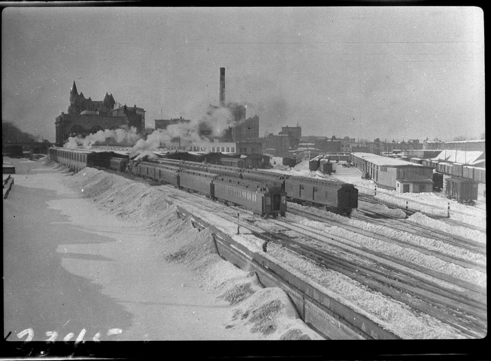
Approach tracks and Bush trainshed, Ottawa Union Station. A wintery scene, with a frozen Rideau Canal on the left. The yards at right are now occupied by the Rideau Centre, Convention Centre, and Department of Defense Headquarters (Library and Archives Canada)
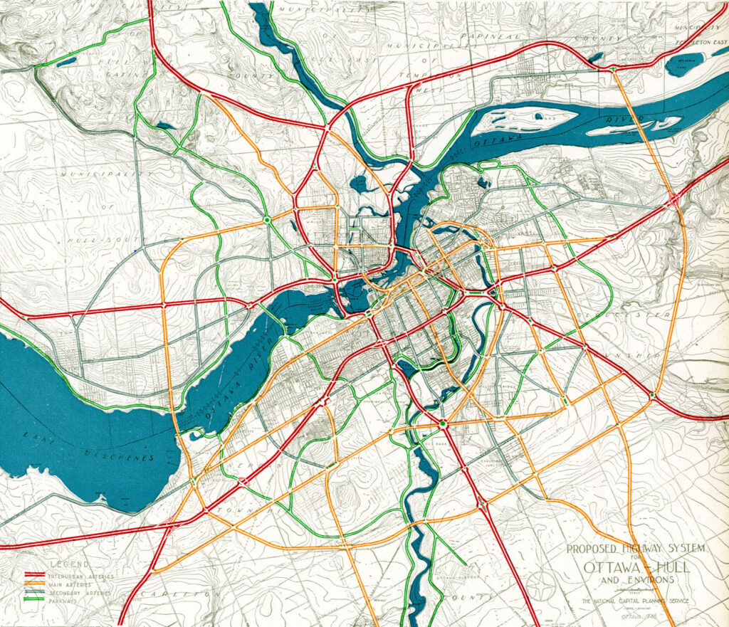
In the 1940s, the federal government led by Liberal prime minister William Lyon Mackenzie King wanted to beautify the nation’s capital region and address traffic congestion. Ottawa — and the federal government — was rapidly growing, while political leaders wanted a cityscape that matched the ambitions of an expanding nation. French urban planner Jacques Gréber was commissioned to plan the region’s future; Gréber’s recommendations, released in 1950, were ambitious and transformative. (You can read the entire report here.)
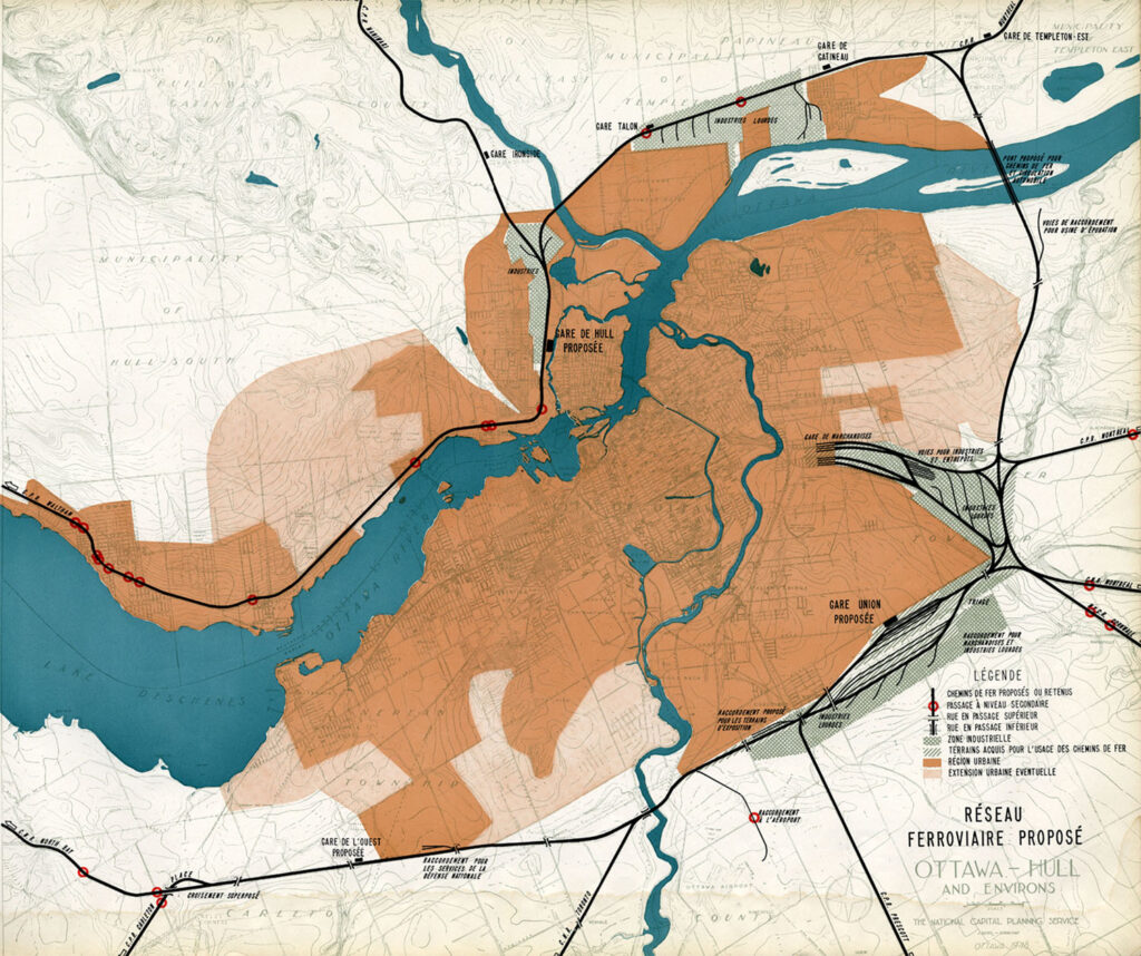
The Gréber Plan — formally titled “Plan for the National Capital” — called for new highways, the abandonment of Ottawa’s streetcars (which were seen as antiquated with unsightly overhead wires), and the removal of all railway infrastructure within the City of Ottawa. The old CN and CPR lines would make way for new roads, including a four-lane arterial along the east side of the Rideau Canal, leading to a new road bridge replacing the Alexandra. A new railway bypass along the periphery of the city would replace all urban trackage, with a proposed new Union Station site in Gloucester Township, south of Walkley Road. Most industrial uses — including the historic paper mills along the Ottawa River — would be moved to the new railway line.
Proposed highway system for Ottawa-Hull and environs, from Gréber’s reportProposed Railway system: Ottawa Hull and environs from Gréber’s report
Though the plan was not fully implemented, it did set the stage for much of the urban planning and infrastructure changes during Ottawa’s next fifty years. The railway bypass was constructed between Bell’s Corners in the west and Ramsayville in the east, with the old Grand Trunk tracks through the city replaced with The Queensway, now part of Highway 417. New parkways lined the rivers and canals. Two new multilane traffic bridges crossed the Ottawa River (though the Alexandra Bridge was maintained for traffic and pedestrians) and Albert and Slater Streets were made one-way, with a new bridge over the Rideau Canal (the Mackenzie King Bridge) linking them to the east. A large Greenbelt encompassed the city region, intended to direct growth while preserving natural areas.
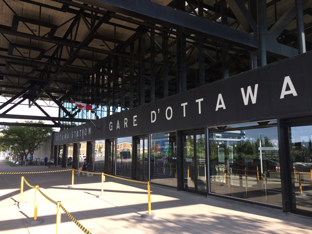
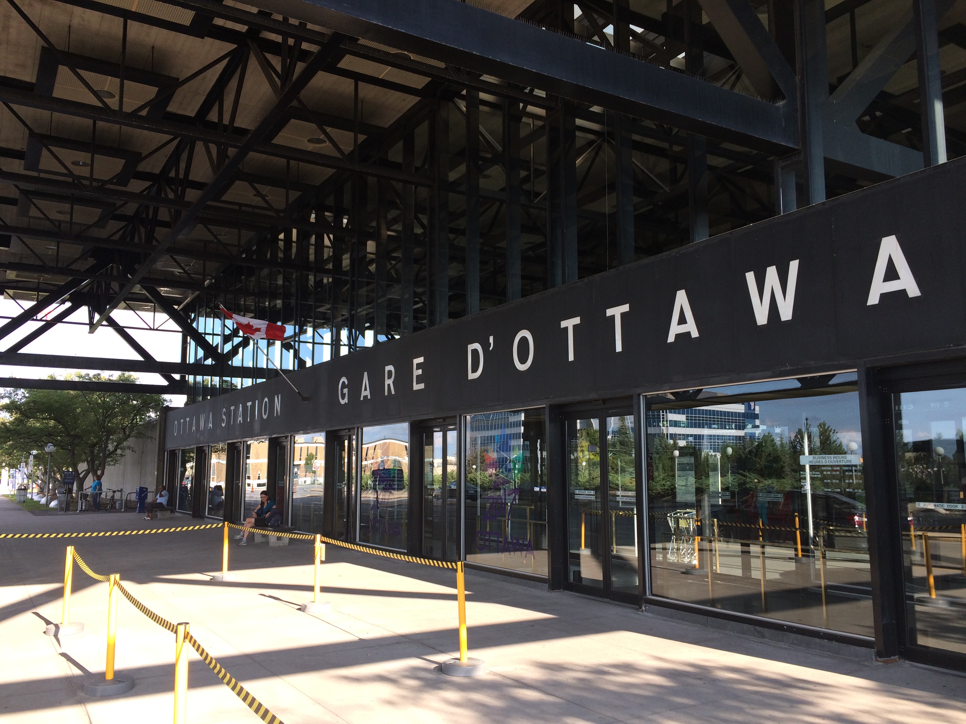
Fortunately, the passenger station was relocated to a point much closer to the city centre than the Gréber Plan envisioned: the old CN and CP tracks along the Rideau River south of the city centre were kept in place but rerouted to serve a new modernist station that opened in July 1966. The new Ottawa Station, designed by John C. Parkin, is one-of-kind. The architecture invokes an airport terminal, with large, sheltered driveways and an airy open lobby/concourse, and was the last grand railway station built in North America. In 1966-1967, there were still two daily transcontinental trains departing from Ottawa Station, along with multiple trains to Toronto and Montreal, including a Toronto-Ottawa night train. Today, there are just eight trains to Toronto and five trains to Montréal.
Ottawa Station, which opened July 31, 1966
Soon after the new station opened, the tracks and ancillary buildings around Union Station were removed, making way for Colonel By Drive, the Rideau Centre shopping mall, a new convention centre, and headquarters for the Department of Defense. The station building itself survived, however, first becoming a temporary museum space during the 1967 Centennial celebrations, then a government conference centre, mostly closed off to the public.
The temporary Senate Chambers in the former train concourse at Ottawa Union Station
Right now, the grand building is the temporary home of Canada’s Senate, and is again accessible to the public, via a free tour. The renovations to the building are very sympathetic to the built heritage. As reconstruction of Centre Block, the regular home of both Houses of Parliament, is still five years away from completion, there’s still lots of time to take the tour.
Awaiting Alto
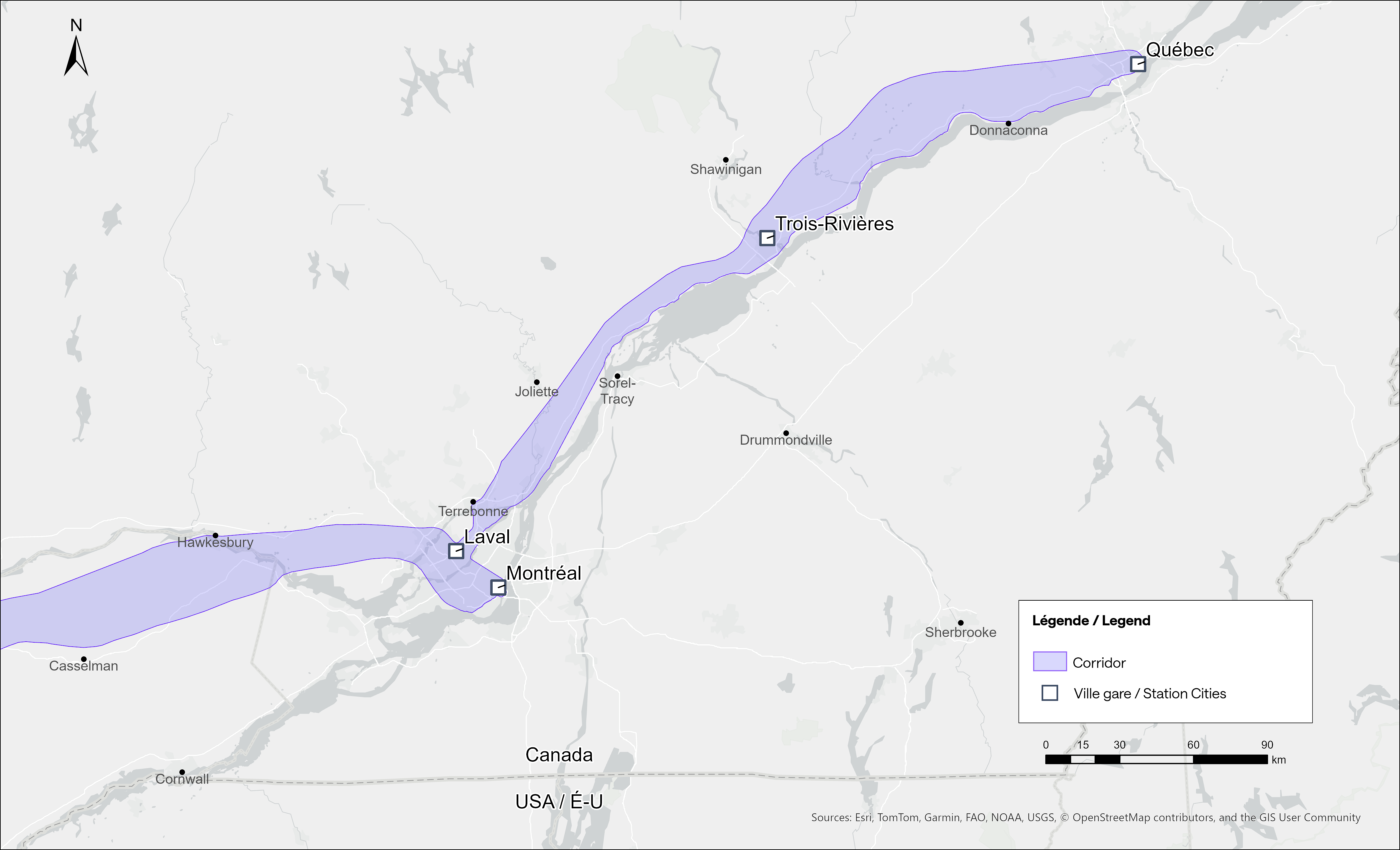
The Alto high speed rail line project, now in the planning stage, will connect Québec, Montréal, Ottawa, and Toronto, with a total of seven stations (the other three are planned in Trois-Rivières, Laval, and Peterborough). The first segment, with the start of construction set for 2029, will link Montréal, Laval, and Ottawa. Consultations on the specific route and station locations are underway, with the broad corridors noted in maps available on the Alto website.
Map of potential routings for the Alto high speed line in OntarioMap of the planned routing for the Alto high speed line in Quebec
The maps clearly show a route between Ottawa and Montréal that will pass through Prescott & Russell Counties, roughly following an abandoned CPR corridor until about Hawkesbury, at which point it would cross into Quebec (following an older abandoned CNoR route) to Laval, then continue south into central Montréal, though not necessarily the existing Central Station (this would likely require a new tunnel under Mount Royal). The Montréal station appears to be a terminal for trains coming from Ottawa and from Trois-Rivières and Québec, much like the existing VIA Central Station.
Alto’s next phase towards Toronto could follow one of two broad routes between Ottawa and Peterborough, either just north of Highway 7, through the Canadian Shield, or a southerly alignment through the Rideau Lakes region and then through South Frontenac and passing near Stirling and Campbellford. All planned routes would require passing through Ottawa entirely on the Ontario side of the Ottawa River, making a through station particularly likely, especially for the critical Toronto-Montréal market.
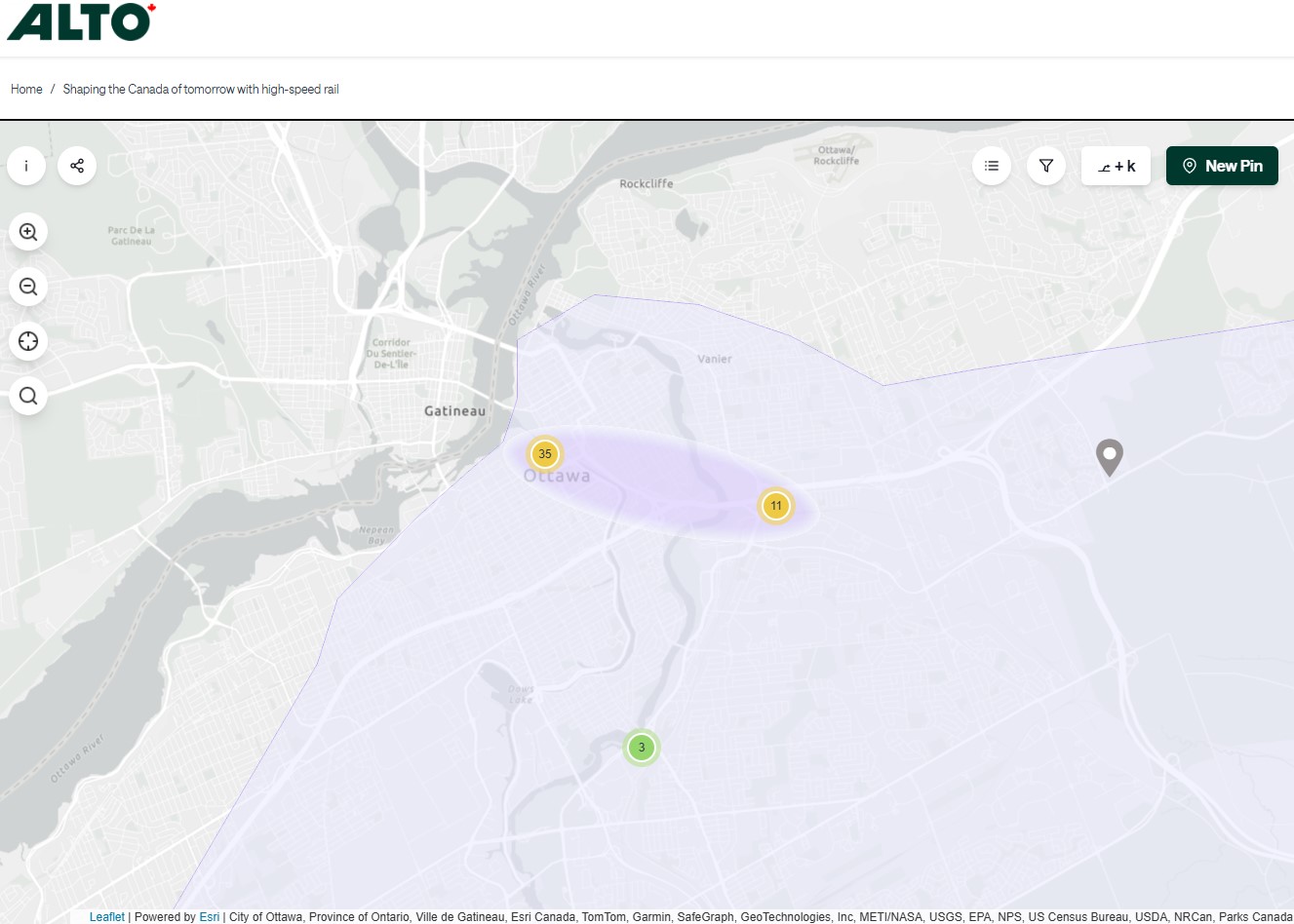
On the detailed consultation map, highlighted areas show where the seven station locations are being considered.
The map for Ottawa shows possible station locations in an area including the current VIA station and the old Union StationThe Montréaland Laval station locations under consideration. The Montréal station area highlighted includes the locations of Central and Lucien L’Allier Stations.The Montréal station for Alto is clearly intended to be a terminal.
The idea of a downtown Ottawa Station for the new high speed rail corridor is certainly enticing. It would breathe new life into a 114-year-old landmark, provide a very convenient spot for Ottawa politicians, public servants, business travelers, tourists, and students attending nearby University of Ottawa. Rideau O-Train Station is less than two blocks away. However, it would require a new tunnel and/or elevated structure to reach the station from the rail corridors to the south. Furthermore, Centre Block would have to reopen on schedule so the Senate can move back before construction can start on refurbishing the station for passenger service.
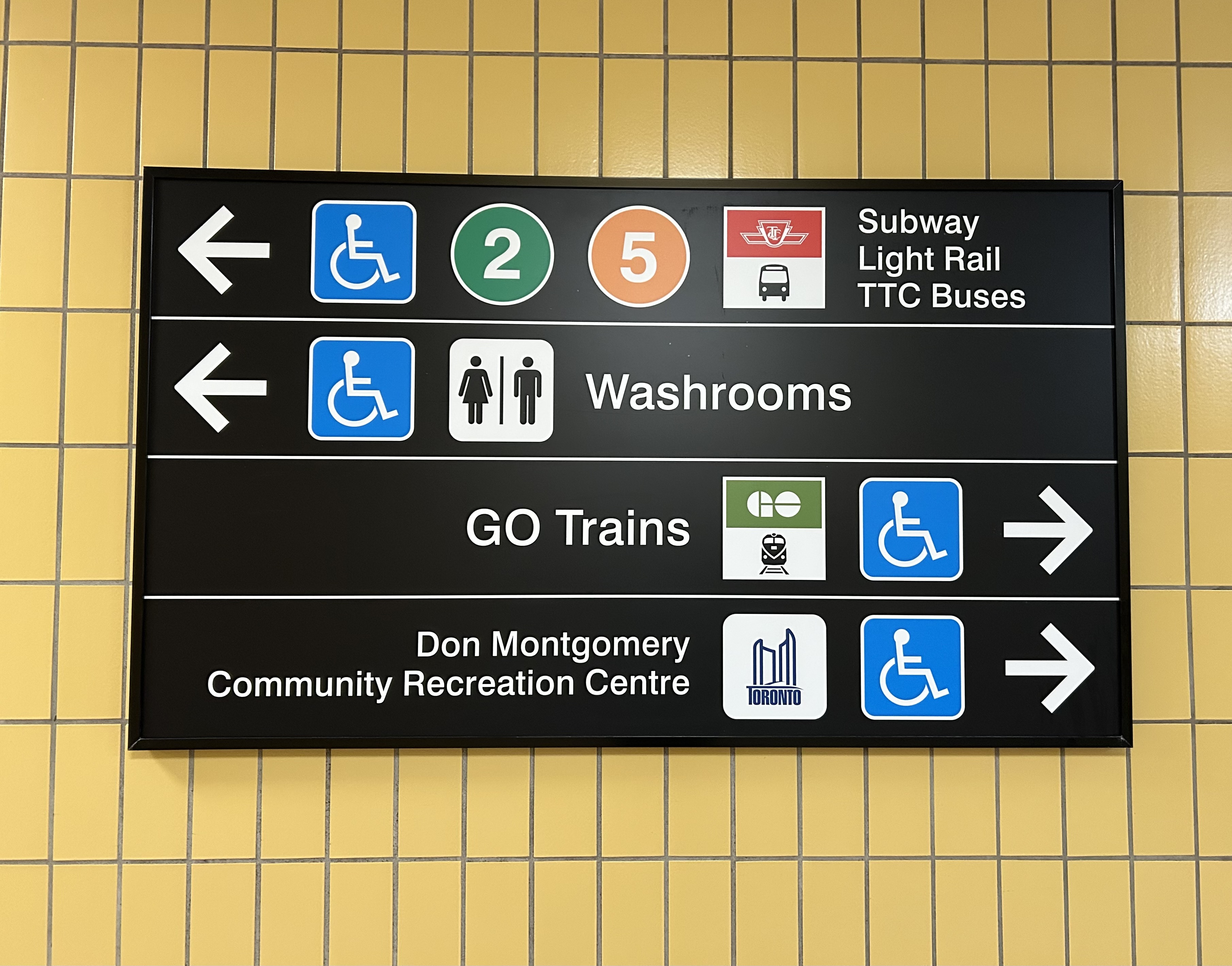
The 1966 Ottawa VIA Station, on the other hand, has its own advantages. There is plenty of room to build new high speed train platforms, which should provide level boarding for efficient passenger movement. There is also room for parking, passenger pick-up and drop-off, as well as easy access to the highway, unlike Union Station. With the closure of the Ottawa bus station, the VIA Rail Station has become a multimodal hub, with Ontario Northland, Flixbus, and Orleans Express all using the station’s driveway, along with a KLM/Air France shuttle to Dorval Airport. There is also a dedicated O-Train LRT station on-site, though it could be better integrated with the station building.
Perhaps most importantly, the existing VIA station can help ensure the existing Corridor service remains integral, as passengers from Kingston, Belleville, and elsewhere on Lake Ontario and the St. Lawrence River will not be served by Alto; neither would Casselman, Alexandria and Dorval. That the station is a through-line, and not a stub-end terminal, will also ensure that the crucial Toronto-Montréal market will see minimal delays from back-tracking and reversing at a downtown terminal. Though there are instances of high-speed trains reversing directions at major hubs — Trenitalia’s Frecciarossa mainline between Milan and Salerno turns back at Roma Termini and at Napoli Centrale — this is an uncommon arrangement.
All the planned Alto high speed rail stations will have to be easily accessible and close to the downtown cores of the cities it serves. At this point in the planning process, this looks like it will be the case at all three big city stations. But it will need more than walk-up traffic like downtown office workers and tourists; it will be most successful as part of a complete network of local, regional and intercity transport, including the conventional VIA rail system. With specific improvements, including new platforms and better O-Train station integration, the modern yet historic 1966 Ottawa Station is well suited for all of these needs.