Category: Urban Planning

  • Ontario municipalities over the barrel, again

    Ontario municipalities over the barrel, again

    Once again, Doug Ford wants to mess with local democracy. This time, it’s in Niagara Region.

    With the recent news overload — yet another war in the Middle East, rising fuel costs, another municipal mayoral race — not to mention the flood of news from Queen’s Park (a new mega-convention centre on Lake Ontario, moves to let bigger passenger jets on an expanded island airport, and legislation to increase secrecy within the highest levels of provincial government), you might be forgiven for missing yet another bit of news.

    In what has become a tradition for failed mayoral candidate and current Progressive Conservative premier Doug Ford, there’s another move to disrupt local democracy, this time in Niagara Region. Since his party was elected to government in 2018, Premier Ford has been busy tinkering with local governance. First was the sudden interference in Toronto’s municipal election, introducing election to force the city to reduce the number of elected councillors from 47 to just 25. That was soon followed by the cancellation of new open elections for regional chairs in Peel, York, Niagara and Muskoka Regions (who are normally appointed by those councils), the introduction of “strong mayor” powers, the aborted dissolution of Peel Region, the consolidation of conservation authorities, and the takeover of elected school boards.

    In the last few weeks, the Ford government set its sights on Niagara Region, pushing for the quick amalgamation of its 13 municipal governments ahead of municipal elections this coming October.

    Niagara Region municipalities, with former Lincoln County townships in blue and Welland County townships in red

    Niagara Region is one of eight regional governments in Ontario, a specialized level of government introduced by an earlier Progressive Conservative government in the 1970s, following on the success of Metropolitan Toronto created in 1954. Regional governments had more powers and responsibilities than counties, including regional planning and the provision of water and wastewater systems deemed essential for smart urban growth. Most regions formed their own police services, and many took on responsibility for household waste management and public transit (Durham, Waterloo, York, and most recently Niagara). Other services, such as fire departments, libraries, local planning, parks and recreation, and local public works remained the responsibility of the cities, towns, and townships.

    The Mike Harris-led PC government, elected in 1995, was a big proponent of municipal amalgamations. After amalgamating the City of Toronto in 1998, it replaced regional governments in the Hamilton, Ottawa, and Sudbury areas with amalgamated cities in 2001, and broke up the former region of Haldimand-Norfolk creating two stand-alone municipalities. Dozens of other amalgamations took place in those years, including Chatham-Kent and Kawartha Lakes (formerly Victoria County). On top of that, provincial costs were downloaded to those new creations, including social and health services and thousands of kilometres of provincial highways.

    That era of drastic municipal change came to an end in December 2003, when a new Liberal government was elected, with relative calm for nearly fifteen years, until June 2018. During that time, the status quo prevailed, without a full review of the operations, finances, and role of municipal governments that would inform good faith reforms.

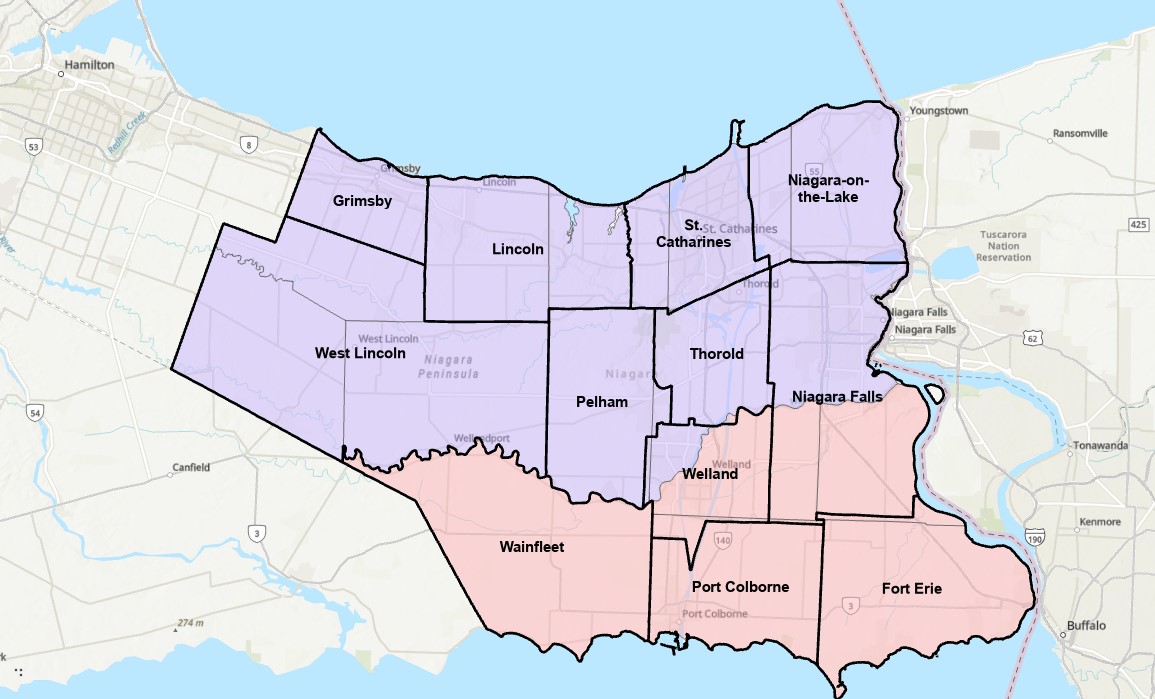
    Niagara Region is made up of twelve lower tier municipalities: the cities of St. Catharines, Niagara Falls, Welland, Thorold, and Port Colborne, the towns of Fort Erie, Grimsby, Lincoln, Niagara-on-the-Lake, and Pelham, and the townships of Wainfleet and West Lincoln. The current region is a result of that earlier wave of regional government establishments in much of Ontario; prior to 1970, Niagara was made up of two counties — Lincoln and Welland — with fifteen townships and nearly a dozen smaller cities and towns between them.

    As with all remaining regional governments, Niagara Region Council is made up of municipal politicians who also sit on their local city or town councils. Each mayor sits on the regional board, and to make up for population disparity between urban centres and rural townships, the larger municipalities send additional councillors who already sit on their local councils. Though some regions have chairs elected by the region’s populations, others have a non-elected chair, typically chosen by the regional council.

    The Niagara problem started when the provincial government used its new authority to appoint its own preferred chair to Regional Council after the previous chair, former Liberal MPP Jim Bradley, died in office in late 2025. Bob Gale quickly promoted regional amalgamation, backed by Premier Ford, citing tax increases and too many local politicians. The idea is unpopular amongst Niagara residents, especially those in smaller communities such as Niagara-on-the-Lake, which under a four-municipality model, would be joined with Niagara Falls (whose mayor backed the idea).

    Repeatedly, it has been shown that municipal amalgamations fail to save taxpayers’ money but only make municipal government more distant to the residents it serves. Though the number of municipal politicians would decrease (there are 126 across the 12 lower-tier municipalities), in smaller towns and rural townships, these are part-time positions. In Toronto, the moves from seven councils down to one in 1998 and from 44 councillors down to 25 in 2018 failed to save operating funds, as the number of paid employees to support each councillor increased to manage their greater workloads. Even the conservative Fraser Institute found no tax savings when studying the effects of amalgamation on smaller Ontario municipalities. Furthermore, with many services already the responsibility of the region, what savings could be had if police, transit, social services, housing, and major roads are already amalgamated?

    For now, the idea of amalgamation in Niagara Region is stalled, but not because wiser heads prevailed. Chair Bob Gale resigned just three months into his term after local anti-hate organizations found he had in his collection of historical artifacts a copy of Mein Kampf signed by its author, Adolf Hitler.

    One of the other problems with a quick amalgamation of such a large area is that there is no study on what boundaries actually make sense. Does the combination of 12 municipalities into just four actually work? Should the new boundaries just lump existing towns together, or more intelligently redraw existing boundaries completely? For example, should the City of Thorold be just thrown in with a neighbour as is, or could be split into three, with the urbanized area joining St. Catharines, the area east of the canal joining Niagara Falls, and the southern rural area joining Pelham and Welland?

    Unfortunately, as hospitals face funding and staffing crises, as students face increasing debt loads to complete post-secondary education, and the economy continues to face headwinds, Doug Ford manages to get bogged down into distractions like shiny new buildings on Toronto’s waterfront, municipal restructurings, and needless new highways. The next provincial election will not come for another three years, and yet the premier wants to play mayor.

  • Ottawa’s Union Station problem

    Ottawa’s Union Station problem

    Great Hall, Ottawa Union Station
    Main lobby, Ottawa Union Station

    With planning now well underway for the Alto high speed passenger rail corridor between Quebec City and Toronto, there has been some speculation that Ottawa’s grand old Union Station, in the heart of the capital’s downtown core and a mere stone’s throw from Parliament Hill, could see trains again. Local business leaders and Mayor Mark Sutcliffe are excited by the idea of a downtown station, expecting that a downtown transport hub would help revitalize the local economy. Though it’s a very attractive idea, there are unfortunately just too many reasons why this would not be feasible.

    To understand why, it’s worth diving into the history and urban politics of railways in the National Capital Region.

    The decline and closure of Ottawa Union Station
    Grand Trunk Central Station soon after opening in 1912 (Library & Archives Canada)

    The Grand Trunk Central Station, opened in 1912, provided a grand entrance to Canada’s capital city that was previously served by a few smaller stations just outside the downtown core. The station, designed in the Beaux-Arts style, was built as a stub-end terminal. This meant that trains would arrive and depart from the south and would have to be backed up to change direction. This suited the Grand Trunk Railway just fine, as it lined up perfectly with its route to Montréal via Alexandria (still used by VIA Rail today). The railway also built a hotel across the street — the Chateau Laurier — and connected the station with the hotel with a pedestrian tunnel.

    Entrance lobby, soon after opening. Note the tunnel under the staircase to the Chateau Laurier. (Library & Archives Canada)

    The 1912 station was intermodal from the very beginning. Right outside the station’s front doors, there were Ottawa Electric Railway streetcar platforms serving several routes on Rideau and Sparks Streets, the two main commercial corridors in Downtown Ottawa. Right below the canal and railway bridge next to the station was the Hull Electric Railway’s loop; its streetcars crossed into Ontario via the Alexandra Bridge.

    Alexandra Bridge
    The Alexandra Bridge carried CPR trains, Hull streetcars, pedestrians, and motor vehicles when it opened in 1901

    Soon after opening, the Canadian Pacific Railway joined the Grand Trunk, resulting in the terminal being renamed Union Station; the short-lived Canadian Northern Railway (CNoR) soon followed. As the CPR’s tracks to Hull (via the Alexandra Bridge) ran next to the GTR’s station, it suited the CPR well. Unlike Grand Trunk, both the CPR and CNoR had direct lines to Toronto.

    Two platforms on the west side of the station allowed through CPR trains to continue towards the Alexandra Bridge and even return to Ottawa via the Prince of Wales Bridge to the west; this was the route the iconic Canadian train between Montréal and Vancouver took when it was inaugurated in 1955. Most trains — including all GTR and CNoR, however, terminated at the six stub-end tracks. Both GTR and CNoR were absorbed into the new Canadian National Railway (CN) by 1922.

    Approach tracks and Bush trainshed, Ottawa Union Station. A wintery scene, with a frozen Rideau Canal on the left. The yards at right are now occupied by the Rideau Centre, Convention Centre, and Department of Defense Headquarters (Library and Archives Canada)

    In the 1940s, the federal government led by Liberal prime minister William Lyon Mackenzie King wanted to beautify the nation’s capital region and address traffic congestion. Ottawa — and the federal government — was rapidly growing, while political leaders wanted a cityscape that matched the ambitions of an expanding nation. French urban planner Jacques Gréber was commissioned to plan the region’s future; Gréber’s recommendations, released in 1950, were ambitious and transformative. (You can read the entire report here.)

    The Gréber Plan — formally titled “Plan for the National Capital” — called for new highways, the abandonment of Ottawa’s streetcars (which were seen as antiquated with unsightly overhead wires), and the removal of all railway infrastructure within the City of Ottawa. The old CN and CPR lines would make way for new roads, including a four-lane arterial along the east side of the Rideau Canal, leading to a new road bridge replacing the Alexandra. A new railway bypass along the periphery of the city would replace all urban trackage, with a proposed new Union Station site in Gloucester Township, south of Walkley Road. Most industrial uses — including the historic paper mills along the Ottawa River — would be moved to the new railway line.

    Proposed highway system for Ottawa-Hull and environs, from Gréber’s report
    Proposed Railway system: Ottawa Hull and environs from Gréber’s report

    Though the plan was not fully implemented, it did set the stage for much of the urban planning and infrastructure changes during Ottawa’s next fifty years. The railway bypass was constructed between Bell’s Corners in the west and Ramsayville in the east, with the old Grand Trunk tracks through the city replaced with The Queensway, now part of Highway 417. New parkways lined the rivers and canals. Two new multilane traffic bridges crossed the Ottawa River (though the Alexandra Bridge was maintained for traffic and pedestrians) and Albert and Slater Streets were made one-way, with a new bridge over the Rideau Canal (the Mackenzie King Bridge) linking them to the east. A large Greenbelt encompassed the city region, intended to direct growth while preserving natural areas.

    Fortunately, the passenger station was relocated to a point much closer to the city centre than the Gréber Plan envisioned: the old CN and CP tracks along the Rideau River south of the city centre were kept in place but rerouted to serve a new modernist station that opened in July 1966. The new Ottawa Station, designed by John C. Parkin, is one-of-kind. The architecture invokes an airport terminal, with large, sheltered driveways and an airy open lobby/concourse, and was the last grand railway station built in North America. In 1966-1967, there were still two daily transcontinental trains departing from Ottawa Station, along with multiple trains to Toronto and Montreal, including a Toronto-Ottawa night train. Today, there are just eight trains to Toronto and five trains to Montréal.

    Ottawa Station, which opened July 31, 1966

    Soon after the new station opened, the tracks and ancillary buildings around Union Station were removed, making way for Colonel By Drive, the Rideau Centre shopping mall, a new convention centre, and headquarters for the Department of Defense. The station building itself survived, however, first becoming a temporary museum space during the 1967 Centennial celebrations, then a government conference centre, mostly closed off to the public.

    The Red Chamber
    The temporary Senate Chambers in the former train concourse at Ottawa Union Station

    Right now, the grand building is the temporary home of Canada’s Senate, and is again accessible to the public, via a free tour. The renovations to the building are very sympathetic to the built heritage. As reconstruction of Centre Block, the regular home of both Houses of Parliament, is still five years away from completion, there’s still lots of time to take the tour.

    Awaiting Alto

    The Alto high speed rail line project, now in the planning stage, will connect Québec, Montréal, Ottawa, and Toronto, with a total of seven stations (the other three are planned in Trois-Rivières, Laval, and Peterborough). The first segment, with the start of construction set for 2029, will link Montréal, Laval, and Ottawa. Consultations on the specific route and station locations are underway, with the broad corridors noted in maps available on the Alto website.

    Map of potential routings for the Alto high speed line in Ontario
    Map of the planned routing for the Alto high speed line in Quebec

    The maps clearly show a route between Ottawa and Montréal that will pass through Prescott & Russell Counties, roughly following an abandoned CPR corridor until about Hawkesbury, at which point it would cross into Quebec (following an older abandoned CNoR route) to Laval, then continue south into central Montréal, though not necessarily the existing Central Station (this would likely require a new tunnel under Mount Royal). The Montréal station appears to be a terminal for trains coming from Ottawa and from Trois-Rivières and Québec, much like the existing VIA Central Station.

    Alto’s next phase towards Toronto could follow one of two broad routes between Ottawa and Peterborough, either just north of Highway 7, through the Canadian Shield, or a southerly alignment through the Rideau Lakes region and then through South Frontenac and passing near Stirling and Campbellford. All planned routes would require passing through Ottawa entirely on the Ontario side of the Ottawa River, making a through station particularly likely, especially for the critical Toronto-Montréal market.

    On the detailed consultation map, highlighted areas show where the seven station locations are being considered.

    The map for Ottawa shows possible station locations in an area including the current VIA station and the old Union Station
    The Montréal and Laval station locations under consideration. The Montréal station area highlighted includes the locations of Central and Lucien L’Allier Stations. The Montréal station for Alto is clearly intended to be a terminal.

    The idea of a downtown Ottawa Station for the new high speed rail corridor is certainly enticing. It would breathe new life into a 114-year-old landmark, provide a very convenient spot for Ottawa politicians, public servants, business travelers, tourists, and students attending nearby University of Ottawa. Rideau O-Train Station is less than two blocks away. However, it would require a new tunnel and/or elevated structure to reach the station from the rail corridors to the south. Furthermore, Centre Block would have to reopen on schedule so the Senate can move back before construction can start on refurbishing the station for passenger service.

    The 1966 Ottawa VIA Station, on the other hand, has its own advantages. There is plenty of room to build new high speed train platforms, which should provide level boarding for efficient passenger movement. There is also room for parking, passenger pick-up and drop-off, as well as easy access to the highway, unlike Union Station. With the closure of the Ottawa bus station, the VIA Rail Station has become a multimodal hub, with Ontario Northland, Flixbus, and Orleans Express all using the station’s driveway, along with a KLM/Air France shuttle to Dorval Airport. There is also a dedicated O-Train LRT station on-site, though it could be better integrated with the station building.

    Perhaps most importantly, the existing VIA station can help ensure the existing Corridor service remains integral, as passengers from Kingston, Belleville, and elsewhere on Lake Ontario and the St. Lawrence River will not be served by Alto; neither would Casselman, Alexandria and Dorval. That the station is a through-line, and not a stub-end terminal, will also ensure that the crucial Toronto-Montréal market will see minimal delays from back-tracking and reversing at a downtown terminal. Though there are instances of high-speed trains reversing directions at major hubs — Trenitalia’s Frecciarossa mainline between Milan and Salerno turns back at Roma Termini and at Napoli Centrale — this is an uncommon arrangement.

    All the planned Alto high speed rail stations will have to be easily accessible and close to the downtown cores of the cities it serves. At this point in the planning process, this looks like it will be the case at all three big city stations. But it will need more than walk-up traffic like downtown office workers and tourists; it will be most successful as part of a complete network of local, regional and intercity transport, including the conventional VIA rail system. With specific improvements, including new platforms and better O-Train station integration, the modern yet historic 1966 Ottawa Station is well suited for all of these needs.

  • St. Clair-Old Weston: find it if you can

    St. Clair-Old Weston: find it if you can

    An UP Express train passes the intersection of Union and Townsley Streets

    At the lonely corner of Union and Townsley Streets sits the site of St. Clair-Old Weston Road Station, one of five proposed new GO stations in the City of Toronto as part of the remnants of the SmartTrack brand. The station’s name (which will likely be revised closer to opening day) refers to the intersection of St. Clair Avenue West and Old Weston Road, one block to the east. After years of benign neglect, the northwest corner of the old City of Toronto is seeing new development.

    The old Heydon House Hotel stands at the corner of St. Clair Avenue and Old Weston Road

    The former Ontario Stockyards and associated slaughterhouses is now a busy retail area. A large cluster of midrise and highrise development proposals are in the pipeline surrounding the station site, spurred on by a city-initiated transportation plan and the provincial major transportation transit area (MTSA) designation. More transit will be needed to serve the planned growth, and that’s where the new station comes in.

    Right now, the corner of Union and Townsley is eerily quiet. At the corner of Old Weston and Townsley, a once-popular flea market was demolished, with no immediate plans for the site. The Consolidated Bottle Company plant on Union Street sits empty, awaiting future development. To the south, the Delta Bingo on St. Clair West is also the site of a planned highrise cluster. There are other proposals along Union Street to the north. But right now, it’s a great place to dump waste.

    A no dumping sign and an abandoned rail spur crossing on Union Street
    Missing sidewalks on Townsley Street, looking west from Old Weston Road
    St. Clair-Old Weston Station site plan

    Despite the promise of new development, the station site plan leaves a lot to be desired. Connections to the nearby 512 St. Clair Streetcar will be awkward. A planned bus loop would require a diversion for nearby TTC bus routes, except the low-frequency 127 Davenport, which terminates by the old flea market site. An underpass that allows St. Clair Avenue to duck under the Metrolinx and CPKC railways will have to be rebuilt, with streetcar closures planned starting next year. Though likely not included (the street right-of-way will not be widened during the work, despite traffic congestion through this pinch point), extending walkways and even rail platforms to the south side of St. Clair would improve connections considerably and reduce walking times to several of the proposed developments. Under the current plan, train platforms would be located entirely north of St. Clair Avenue, with no direct station access from the busy arterial.

    The narrow St. Clair Avenue underpass, a traffic pinch point, is due for replacement

    But now, as St. Clair-Old Weston will likely only be served by UP Express trains, there’s at least an opportunity to improve the station layout.

    Back to “The revenge of SmartTrack”

  • Let’s not be jealous of Montreal

    Let’s not be jealous of Montreal

    Rue St-Catharine in the Quartier des Spectacles, August 2025

    A visit to Montreal can make one jealous. Jealous of the city’s better street furniture, greater cycling infrastructure, great public spaces throughout the city, and an improved pedestrian realm. Entire streets are closed in the summer months to motor traffic, allowing pedestrians to spill out into the roadway, and patios to sprout without the need for concrete blocks to protect them (and less noise and pollution to those dining al fresco).

    For example, Avenue Mont-Royal, was first closed in Summer 2020 as a “Corridor Sanitare” to encourage people to get outside during the first wave of the COVID-19 pandemic and support local businesses, which set up patios on the sidewalk and the street. My spouse and I rented a car and visited Montreal during this time, getting a lot of walking in a city that opened up as much as safely possible.

    Avenue Mont-Royal, looking east, August 2020

    Happily, Montreal continued the tradition in the years since, even as pandemic restrictions eased, then disappeared entirely. Five years later, Avenue Mont-Royal was even more vibrant. Not only were there lots of patios on the street, there were public benches, shade structures, and water fountains, allowing anyone to sit, relax, and enjoy the outdoors. The annual summer closure is a hit.

    Avenue Mont-Royal, looking east, August 2025

    Several public squares were also renewed in recent years. Phillips Square, on Rue Ste-Catharine across from the now-shuttered Hudson’s Bay department store, was renewed with new splash fountains along with small café-style tables and chairs, complete with shade umbrellas. The metal chairs are movable, allowing larger groups to sit around a single table. It’s a refreshed natural congregation point along the city’s main shopping street.

    Phillips Square, August 2025

    Similar tables and umbrellas were set up at Dorchester Square, several blocks to the west, near Mary, Queen of the World Cathedral and Central Station. Both squares were reimagined by the brilliant landscape architecture firm Claude Cormier + Associés. At Dorchester Square, a new water fountain, seemingly a classic installation, is cut in the rear, with a woodpecker behind. Such Easter eggs are features of Cormier park projects.

    Dorchester Square, August 2025
    Fountain at Dorchester Square; note the woodpecker on the side. One of the two black curved footbridges across the parking ramps is behind.

    Furthermore, Montreal is rebuilding the western section of Rue St-Catharine towards Crescent. Though motor vehicles are permitted after reconstruction, they are limited to a single through lane, with lay-bys for deliveries, passenger pick-ups and drop-offs, and emergency vehicles. Sidewalks are widened considerably, with more benches, bicycle parking, and street trees.

    Completing Rue St-Catharine, near Bishop Street

    After returning to Toronto, it’s easy to feel down on this city. Montreal seems to do everything right. Meanwhile, ActiveTO, the open streets initiative following the pandemic restrictions here, quickly eroded, and was effectively ended in 2022. Open Streets, which closed sections of Yonge and Bloor Streets to motorists for two Sunday mornings, was last held in 2022. But there are still business improvement area-led weekend street festivals, which attract tens of thousands of pedestrians.

    Torontonians want to walk, and pedestrianized streets, even when they’re just weekend events, are immensely popular. One downside, however, is a lack of seating outside of businesses’ patio areas. One is free to walk, enjoy live music, or just people watch, but to sit down, one is compelled to purchase something from one of the businesses with a sanctioned patio.

    Torontonians love a street festival: Cabbagetown in September

    There are a few other successes. A small segment Gould Street at Toronto Metropolitan University was pedestrianized and rebuilt as a central plaza for that university campus. A short section of Willcocks Street at the University of Toronto was similarly pedestrianized.

    But the best example in Toronto is Market Street, which abuts St. Lawrence Market. Patio space and Muskoka chairs provide plenty of seating, without obligation to purchase anything (though it provides additional seating to those who picked up a snack or lunch inside the market). The shade umbrellas and high-quality surface materials and street furniture make this a wonderful oasis in Toronto’s downtown core.

    Market Street looking north from The Esplanade. St. Lawrence Market is on the right.

    Planning for Yonge Street’s makeover, which will include narrowing the roadway, widening the sidewalks, improvements to the public realm, and seasonal closures of selected sections of the traffic lanes, is complete. Unfortunately, the YongeTOmorrow improvements will have to wait for another five years (work starting in 2030) due to Ontario Line construction.

    Rendering of Yonge Street looking north towards Dundas, once YongeTOmorrow improvements are complete

    There are also other great things happening in Toronto. Claude Cormier was tapped to create new public spaces, such as HtO Park and Sugar Beach on the Harbourfront, but also reimagine existing places such as Love Park (previously a highway off-ramp) and Berczy Park, home of the popular Dog Fountain. At Love Park, not one of the 45 movable chairs have been taken (though one ended up in the pond). Torontonians have been shown to cherish great public spaces.

    Toronto has made a lot of progress on improving its public realm, and it has shown that it is willing and able to close streets to traffic for the benefit of pedestrians and cyclists. Though it is so very easy to envy Montreal for its greater progress in the last two decades, it is up to us to continue the momentum Toronto does have, and work harder to push for change, even when there’s a car-focused provincial government. Streets can be narrowed, parks can be improved, and streets can be handed over to the people. Additional seating and more public washrooms will open up this city to many more residents and visitors.

    This should all be a key pillar of a progressive agenda in next years’ municipal election. When certain candidates talk about tax cuts, austerity, and crime, there needs to be a focus on creating a better quality of life to provide an alternative. And that talk must be backed up with action, with quick wins that don’t require multi-year waits.

  • Why Wasaga Beach needs to be open to all

    Why Wasaga Beach needs to be open to all

    "Welcome to Wasaga Beach" billboard

    In late July, online news outlet PressProgress reported on the provincial government’s plans to divest itself of 60 percent of the beach areas of Wasaga Beach Provincial Park, transferring the waterfront lands to the Town of Wasaga Beach. This report raised a number of concerns, including environmental issues (the beach is an important habitat for the piping plover, an endangered species of shorebird which breeds on sandy shorelines), as well as continued public access to the world’s longest freshwater beach. By amending legislation to transfer these lands from provincial to local control without future votes in the legislature, future provincial park lands could also be sold off to municipalities or to the private sector.

    Wasaga Beach Provincial Park and proposed areas for removal and transfer to the municipality

    For its part, the province claims that this will only be a one-time transfer, intended entirely to promote economic development in Wasaga Beach and Simcoe County. It is also providing money to redevelop existing commercial areas, partially destroyed by arson in 2007, and rebuilding a road that borders the beach.

    Sign touting provincial funding for Wasaga Beach's beachfront redevelopment
    Sign touting provincial funding for Wasaga Beach’s beachfront redevelopment

    Amending the Act to permit the divestment of protected lands is a bad precedent, though arguably it was already set by the privatization of much of Ontario Place for the troubled Therme spa development. The closed Ontario Science Centre grounds remain in limbo as well.

    As Shawn Micallef recently pointed out in the Toronto Star, much of Ontario’s prime lakefronts are privatized or purposely made inaccessible to outside residents — not just the popular Muskoka Lakes, but also much of the Great Lakes shores, such as in Tiny Township near Midland. The big, popular, beach areas are worth preserving and expanding, not only to meet current demand, but also provide sustainable and affordable getaways for a growing population in Southern Ontario.

    The beautiful sand at Wasaga Beach Provincial Park on Thursday, August 14

    That demand for summer lake access brings up another challenge — how to get people to and from beach destinations. In Toronto, the lineups for the Island ferries are notorious in the summer. The compound where ferry-goers are forced to wait only adds to the inhospitable atmosphere, though temporary shade structures were added for 2025. The beach at Ontario Place, one of the cleanest on Lake Ontario, has been closed off for the controversial Therme spa construction.

    For those living in Toronto’s suburbs, or anyone looking to avoid the downtown congestion, to get to a good beach will probably mean a road trip to somewhere like Wasaga Beach, Sauble Beach, Grand Bend, Port Dover, Long Point, or Prince Edward County. Many of these places are completely inaccessible without a car, or at best, have limited bus options. Furthermore, even where there is a transit link, the best beach areas are nowhere near where the bus or train makes its stops. Even though Brampton is a straight shot up Airport Road to Georgian Bay, driving is the only reasonable way to get to Wasaga Beach (as I will get into in the second half of this post).

    Right now, Wasaga Beach and Collingwood – a four-season resort town – are connected to Toronto, Barrie, and elsewhere only by two-lane roads: Highway 26, Airport Road, and Sunnidale Road. These roads are often congested with both visitors and with regular traffic. Highway 400 up to Barrie is already being widened, but it too will face additional traffic from population growth in Simcoe County and additional leisure travel.

    If Wasaga Beach goes ahead and develops transferred provincial parklands for more intensive economic development, it will have to contend with these transportation challenges. That will mean wider roads and new highways, improved transit links, or both.

    Local and regional buses behind a Loblaws superstore parking lot in Wasaga Beach

    The way to Wasaga

    There are currently two ways of getting to Wasaga Beach without a personal vehicle or a taxi ride.

    There is one daily Flixbus coach trip from Downtown Toronto and Pearson Airport to Wasaga Beach, continuing onwards to Collingwood, Owen Sound, and Port Elgin. Northbound, the bus leaves Union Station Bus Terminal at 7:30 in the morning and arrives in Wasaga Beach at 10:00. The return bus leaves Wasaga Beach at 4:20 PM and arrives at Union Station at 6:50 PM, though traffic conditions can certainly impact those times. This bus is often nearly or completely sold out.

    Flixbus loads in front of an Esso gas station on Mosley Street at 45th Street

    A cheaper and more frequent option is Simcoe County Linx, a regional bus service provided by the County of Simcoe. Linx Route 2, which connects Wasaga Beach to Allandale Waterfront GO Station, connects with GO buses and trains as well as local Barrie Transit buses. Unfortunately, the Simcoe County Linx system has limited service hours, and routes do not necessarily connect with each other. The last buses on Route 2 leave Wasaga Beach and Barrie at 6:30 PM, and there is no weekend or holiday service. (The sole exception is Linx Route 4, which runs between Collingwood and Wasaga Beach seven days a week.)

    Both Flixbus and Simcoe County Linx stop on the west side of town, seven kilometres from the main tourist area at Beach Area 1. There are two Wasaga Beach Transit routes connecting these two points, but service is every 60-90 minutes. The limited bus options, combined with a lengthy transfer to get to the main beach areas, makes for an unpleasant trip. The early shutdown of Simcoe County Linx limits the time one can spend in Wasaga Beach, especially if it means a local bus transfer back to the west end of the town.

    Wasaga Beach Transit
    Wasaga Beach Transit minibus, decorated with vinyl wrap and stand-up paddleboards affixed to the roof

    From Brampton or Mississauga, travellers must get to either Union Station or Pearson Airport to get the direct Flixbus service or get to the Barrie GO Corridor in order to make the transfer to Simcoe Linx. If there was only a direct bus up Airport Road from Peel Region, Wasaga Beach would be more accessible to another 1.5 million residents.

    Furthermore, the only connections to Wasaga Beach are via Airport Road from the south and via Highway 26, a mostly two-lane highway between Barrie and Owen Sound. Wasaga Beach has never had rail access, and the former Barrie-Collingwood Railway through Stayner has been torn up. Both roads are increasingly congested due to both tourist travel and regular commuter traffic; the towns of Collingwood, Wasaga Beach, and Stayner are all growing with new residential subdivisions. Costco is constructing a new retail warehouse at Mosley Street and Highway 26 on the Wasaga Beach’s west side.

    This is not just a Wasaga Beach problem. Access to most of Ontario’s other great beaches and resort towns is even more limited. Prince Edward County has a weekday-only bus service between Belleville, Bloomfield, and Picton, but it does not serve Wellington (home of the Drake Devonshire Hotel) or Sandbanks Provincial Park. Port Dover only has a weekday-only on-demand transit service accessible from Simcoe; Sauble Beach is only served by the same Flixbus route that runs through Wasaga Beach. At least Huron Shores Area Transit provides daily service to Grand Bend from both Sarnia and London.

    Port Stanley used to have regular electric train service from London — where the municipality owned the railway — until 1956. Even though bus services took over from the L&PS, the only way to get there these days is to drive.

    Though several Ontario cities have good urban beaches, accessible by transit — Ottawa’s Britannia Beach and Petrie Island, Hamilton Beach, and Toronto’s many beaches certainly count — there really should be better access for all to the great summer destinations like Wasaga Beach. That not only means protecting the land for public use and environmental preservation, but it also means providing accessible, sustainable, and equitable access by bus and rail. As Wasaga Beach and Collingwood seek to grow their populations and their economy, more transit is needed to connect residents to those additional jobs.

    To start, Simcoe County Linx should operate Route 2 evenings and weekends. In the longer term, Simcoe County, its constituent towns, and the cities of Barrie and Orillia should merge their transit systems, focusing on fare integration and facilitating easier transfers between its routes and with GO Transit. There is also room for more intercity bus services between the Greater Toronto Area — particularly Mississauga and Brampton — with Wasaga Beach and Collingwood, offering more capacity and faster, more direct options. On my way home on Thursday, August 14, it took me over four hours to get back to Toronto Union Station via Simcoe County Linx and GO Transit buses; driving takes less than half that time, even with traffic.

    Wasaga Beach is a treasure of provincial significance. It deserves to remain owned by the public and fully open to all, with better access to those who can’t or don’t want to drive.

  • Buses to the big box

    Buses to the big box

    Timmins Transit bus headed west from downtown to Wal-Mart

    Last month, I found myself intrigued by American transit consultant Jarrett Walker’s observations about the difficulties of getting to Walmart stores by public transit in US cities. On Bluesky, Walker examined the long walks through hostile environments between Walmart stores and the nearest bus stops, and it is an interesting thread.

    In many US cities, Walmarts are often some of the busiest transit destinations.Here is the typical relationship between a Walmart (far right) and its nearest bus stop (far left).Note the details of the pedestrian experience between one and the other. 1/🧵

    Jarrett Walker (@humantransit.bsky.social) 2025-07-19T18:33:32.331Z
    Jarrett Walker’s BlueSky thread on US Walmart locations

    In response, I noted the more typical experience in midsized Ontario cities. Though American and Canadian land use policies are similar in many ways, complete with the post-1990s proliferation of “big box” retail developments, there are some significant differences. For example, local transit systems will often make an effort to serve big box retail clusters, particularly Walmart stores.

    This is something we do a bit better here in Canada. Below are Google Map screenshots of four Walmarts in small Ontario cities.

    Sean Marshall (@seanyyz.bsky.social) 2025-07-19T18:48:29.558Z
    BlueSky post that shows Walmart stores and bus stops in four small Ontario cities: Orillia, St. Thomas, Belleville, and Brockville

    Walmart stores are important to transit riders, especially in smaller urban centres that have few or no other major shopping centres. Most Walmart stores now have an in-store pharmacy, carry a full selection of groceries, and have ancillary services, such as medical clinics, haircutters, and opticians. Walmart itself will typically anchor a larger commercial development with other big-box retailers such as Home Depot or Canadian Tire. These commercial developments and surrounding areas will have up to have several hundred employees, some of which may also rely on transit.

    From the 1960s to the early 2000s, regional shopping malls were often major transit hubs in mid-sized cities and suburban municipalities in Canada, typically located in space set aside in the mall parking lot. For the most part, Canadian commercial landlords were willing to provide the space; in some cases, the terminal was even right outside one of the main entrances.

    In my hometown of Brampton, for example, two of the three major transit terminals were Bramalea City Centre and Shoppers World. Mississauga’s main transit hub is at Square One mall; Hamilton has large bus loops at Limeridge and Eastgate malls, and London has transit hubs at Masonville Place and White Oaks Mall. Smaller cities and towns such as Belleville, Orillia, and Peterborough would also be sure to serve the local shopping mall with at least one route stopping on the mall property, typically in a space set aside on a mall driveway.

    Sometimes, these mall terminals become too small or too difficult for buses to get in and out of. Brampton Transit grew, the Shoppers World and Bramalea City Centre terminals were moved to larger facilities off-site with better road access, but still close to the malls. In smaller cities, where the importance of enclosed shopping malls (anchored by traditional retailers such as Sears Canada, Zellers, and Hudson Bay) declined in favour of big-box retail, often located on the urban outskirts, the buses followed where their passengers needed to go.

    St. Thomas (Railway City Transit) and Middlesex County Connect minibuses wait for passengers in front of Walmart and Real Canadian Superstore

    In St. Thomas, a small city of about 45,000 people, the main transfer point is in front of the Walmart store parking lot, meaning that every bus rider gets a one-seat ride to the SmartCentres-managed property, which also includes a Loblaws grocery store, Canadian Tire, and over a dozen smaller stores, restaurants, and banks. The recent relocation of the transit hub from a struggling downtown to the big box centre to the west — which is actually closer to the city’s geographic centre — makes sense. It now also serves as the transfer point to the regional bus service to London.

    In Brockville, another small city in Eastern Ontario, the two transfer points are in the downtown and at “Box Stores Transfer” in the northeastern corner of the municipality. The latter is also the transfer point to the inter-municipal River Route to Prescott and Cardinal. In other smaller Ontario cities, including Belleville, Chatham, Orillia, Sarnia, and Timmins, there is at least one bus route extending to the end of the urbanized area to serve the Walmart and/or other large big box retailers. Often the stop will simply be called “Walmart” or “SmartCentres.”

    Sometimes, larger cities will have transit terminals in the middle of big box parking lots. On the south end of Sudbury, GOVA’s Route 1 Mainline terminates in front of a Walmart parking lot, with connections to three local feeder routes. A similar set up can be found in the north end of Guelph. In Waterloo, a large big box complex on the edge of the region’s urban boundary, Boardwalk, was designed with a central transit hub.

    Though the examples here are all Ontario examples, the pattern generally holds across Canada, from St. John’s, Newfoundland to Nanaimo, British Columbia, though there are many exceptions. It also helps that many Canadian Walmart stores are located in shopping malls as they are in renovated and/or expanded former Woolco or Zellers stores.

    Despite these attempts to provide transit services to retailers like Walmart, these are not ideal set ups. Shopping malls were designed as pedestrian environments within large parking lots. As long as there is a convenient, safe, and short walkway to the mall entrance, transit riders could be well-served. This is much harder with contemporary big box retail, as they are designed completely different. With malls, parking lots surround a cluster of stores. Most big box developments have the stores surround gigantic parking lots. Even if walkways and bus facilities were included in the site plan, there are still long, unsheltered walks between the bus stops and store entrances.

    Trinity Common Shopping Centre at Highway 410 and Bovaird in Brampton. The red lines mark where the buses stop.

    An early attempt to create a more transit and pedestrian site plan in a big box centre was Trinity Common in Brampton, which opened in stages in the early 2000s. There were distinct roadways, complete with sidewalks and street lighting; in the centre, surrounded by restaurant pads, were several bus bays and a transit terminal office. Several busy Brampton Transit bus routes converge here rather than simply stop on the adjoining multi-use roadways. Even so, the distances between retailers — which include Canadian Tire, a Metro supermarket, Home Depot and Brampton’s only multiplex cinema — make walking unpleasant.

    But at least, unlike the American examples Jarrett Walker highlighted, there’s an attempt at doing better. Hopefully, the next generation of retail centres — mixed use developments with residential uses on upper levels — do better with incorporating the needs of pedestrians, cyclists, and transit users.

  • Deadly by design: Burnhamthorpe Road

    Deadly by design: Burnhamthorpe Road

    A dented light pole is the only indicator of a deadly collision in Mississauga City Centre

    On Saturday, June 7, around 10:20 AM, the drivers of two vehicles collided in the intersection of Burnhamthorpe Road and Kariya Drive in central Mississauga. One of the two cars that collided, a Tesla sedan, slid onto the sidewalk on the southeast corner, hitting a traffic pole, and then colliding with two pedestrians waiting at the corner to cross the street. One of the two pedestrians, a man in his forties, was killed; the other was taken to hospital with serious injuries. CBC Toronto, CP24/CTV News and the Toronto Star covered the collision.

    Unfortunately, there has been no follow-up reporting so far, and there is no press release or statement on the Peel Regional Police website.

    Screenshot of CP24 news report showing the badly damaged Tesla that crashed into two pedestrians

    A few days later, I visited the area to take note of the intersection and the surroundings.

    The intersection of Burnhamthorpe and Kariya is within the busy, urbanizing Mississauga City Centre (MCC) neighbourhood. MCC, also known as Downtown Mississauga, is the political, commercial, and cultural centre of the sprawling suburb of 750,000. The area is centred around Square One Shopping Centre, which opened in 1973, expanding several times in the next four decades to become one of Canada’s largest malls. Immediately to the west of Square One is Mississauga’s post-modern city hall, which is one of the most interesting and walkable civic centres in Ontario. Nearby is a performing arts theatre, a Sheridan College campus, several office buildings, a YMCA, central library, parks, a transit hub, as well as many high-rise residential towers. Newer residential development includes streetfront retail, oriented to the community with local restaurants, cafes, pharmacies, and grocery stores. Despite its greenfield suburban origins, Mississauga City Centre has become a true 15-minute city.

    Looking north on Confederation Parkway towards MCC
    Looking north on Confederation Parkway near Central Parkway, where MCC’s high-rise condominiums tower over older single-family homes

    The problem, though, is despite its impressive growth, MCC’s built infrastructure still has the trappings of a suburban speedway. Though some collector streets and minor arterials, like Living Arts Drive and Confederation Boulevard, are more human-scaled, with bicycle lanes, wider sidewalks, benches, and street trees, other streets have not been updated to suit the emerging urban environment. Burnhamthorpe Road is the best example of this.

    Looking east on Burnhampthorpe
    Looking east on Burnhampthorpe Road from Kariya Drive, towards Hurontario Street and the landmark Absolute condo towers

    Burnhamthorpe Road is six lanes wide, with an additional left turn lane at every intersection. Though there is a sidewalk on the south side and a designated multiuse path (MUP) on the north side, it is not a pleasant place to walk.

    Looking west on Burnhamthorpe
    Looking west on Burnhamthorpe Road, towards newly built and under-construction high-rise residential towers

    While I visited The MUP on the north side of Burnhamthorpe west of Kariya Drive was also closed off for the convenience of the builders of the Exchange District Condos development, one of many new mixed-use projects in the area. This forces pedestrians to cross the intersection to continue west, and no thought was made to closing one of the three westbound traffic lanes to provide a continuous path.

    Signs blocking path
    Multiple “sidewalk closed” bike lane detour, and “dismount and walk” signs blocking the asphalt MUP on the north side of Burnhamthorpe Road. Note that no traffic lanes were blocked to provide a continuous route for vulnerable road users.

    The intersection of Kariya and Burnhamthorpe is quite busy; at every light cycle, there were multiple pedestrians crossing here on mid Tuesday afternoon, including students walking to the mall or to home from nearby schools, couples and young families out for a stroll. (Kariya Park, named for a Japanese city that was twinned with Mississauga in 1981, is a lovely oasis.) Burnhamthorpe has a 60 km/h speed limit, though Kariya has a 40 km/h limit.

    Five pedestrians, standing where a man was struck and killed last Saturday, about to cross Burnhamthorpe Road on a Tuesday afternoon

    The corner is also a busy transfer point. Miway route 26 Burnhamthorpe is a major east-west bus corridor that connects with the TTC subway at Kipling Station; Kariya Drive is the best stop to get to Square One as Route 26 doesn’t serve the main terminal. Routes 3 Bloor and 8 Cawthra, which do continue to the City Centre Terminal, stop here as well.

    Route 26 Burnhamthorpe is one of MiWay’s busiest

    Also worth noting is that Kariya Drive is a signed school route. MCC itself does not have any elementary or secondary schools, but there are several schools within a short walk to the south of Burnhamthorpe, including Fairview Public School, Elm Drive Public School, St. Giovanni Scalabrini Catholic School, and Fr. Michael Goetz Catholic High School. The more people move into MCC, the more necessary safe walking routes will be.

    School route sign at Kariya Drive
    A school route sign with walking paths to three nearby elementary schools at Kariya Drive and Fairview Boulevard

    There is nothing particularly remarkable about the intersection of Burnhamthorpe Road and Kariya Drive itself that makes it deadly, but that is the problem here. To make walking safer and more attractive, there is much that should be done. Reducing Burnhamthorpe to four lanes in each direction, along with more street trees, could help to reduce speeds (the speed limit should also be dropped to at least 50 km/h), and with several nearby schools, parks, and YMCA, there’s a case for Burnhamthorpe to be designated a community safety zone, with increased enforcement, along with automated traffic cameras. Perhaps dedicated bus lanes could supplant the third traffic lane in each direction, as the nearby Hurontario LRT nears completion.

    Right now, drivers race through the intersection, making left turns against oncoming traffic and crossing pedestrians after the advance arrow signal disappears, as seen in the video below. Wide lanes and a 60 km/h speed limit encourage unsafe driving.

    Three motorists continue to make left turns from Kariya to Burnhamthorpe (behind the FedEx truck) after the advance turn arrow disappears and the green light for opposing traffic and walk signal turn on. Note several pedestrians waiting to cross as drivers rush through.

    To make Mississauga City Centre a complete urban hub, it needs to be safe for pedestrians and cyclists of all ages and abilities to get around. Six-lane arterials like Burnhamthorpe have no place in a dense, multi-use neighbourhood, especially when nearby Highway 403 can handle goods movement and through traffic. One death is too many.

  • How a transit authority has become a barrier to active mobility

    How a transit authority has become a barrier to active mobility

    Metrolinx rendering of the planned new Drury Lane pedestrian overpass in Burlington

    On the home page of Metrolinx, the provincial agency tasked with building and operating regional transit in the Greater Toronto and Hamilton Area and beyond, there is a statement under the heading “Connecting Communities.”

    The Greater Golden Horseshoe is growing, and you need to get places. Our transit projects will connect new, established and emerging communities across the Greater Golden Horseshoe.
    Metrolinx

    Unfortunately, the very same transit projects and rail corridor upgrades can serve to disconnect, rather than connect, communities. Too often, GO Transit lines are secured without regard to the neighbourhoods they run through, without simple and convenient crossings for pedestrians and cyclists. Where overpasses are provided, they are built in such a way that makes them more difficult than necessary to cross.

    A GO Transit train passes under the existing Drury Lane pedestrian overpass

    Take the example of the planned replacement of the Drury Lane pedestrian overpass in Burlington, which connects Fairview Avenue to the south and Orpha Street and a postwar residential neighbourhood to the north. With Burlington GO Station only 500 metres to the west, the pedestrian overpass provides a useful connection to GO and Burlington Transit services as well as (the station’s north end is poorly connected to the Orpha Street area, it is primarily a motor vehicle access to a large parking structure). Drury Lane continues south of Fairview Street towards Burlington’s Central Park, the city’s main library branch, and leads towards the waterfront and downtown core. Unlike Brant Street, Fairview Street, or Guelph Line, Drury Lane is relatively quiet, with painted cycle lanes.

    The planned new Drury Lane pedestrian overpass in Burlington with lengthy access ramps

    The new overpass, replacing the existing 50-year-old structure, will be taller, with longer approach ramps. Metrolinx touts the improved accessibility of the new bridge, even though it will add more time to travel times with an extra ramp segment on each end. No stairs are provided to provide a short-cut for those able to navigate steps.

    The new bridge’s increased height will provide additional clearance for the planned electrification of the Lakeshore West rail corridor.

    Existing ramps at the north (Orpha Street) end, which requires three full turns to reach the top

    A simpler solution would have to build an underpass, which would require a much shorter vertical route for pedestrians and cyclists. Indeed, the rails are on a slight embankment above street level already. A wide, well-lit underpass would improve accessibility; in fact, pedestrian underpasses are provided at nearly all GO rail station where grade separations are required as they provide quicker and easier access between platforms and the station building, parking and bus stops.

    Though it has yet to open, the Paton Road connection under the GO Barrie Line in Toronto shows how a wide pedestrian underpass could look.

    There are many other opportunities for safe and accessible pedestrian and cycling infrastructure along GO Transit corridors. The best example might be in North York, where the combination of a Metrolinx rail corridor and a twelve-lane Highway 401 make pedestrian and cyclist movement especially difficult and unsafe. At one time, it was easy (though still illegal) to cross the tracks between Floral Parkway, a residential street running east-west from Keele Street to the GO Barrie Line, to Bridgeland Road, an industrial street connecting to Caledonia Road and leading towards Yorkdale Mall.

    By the late 2000s, new fencing was put up to prevent pedestrian crossings here; this was further upgraded with reinforced chainlink fences, and more recently, a noise wall. Metrolinx knew this was a popular place to cross, but instead of providing a safe route (either a signalized and gated at-grade crossing, an overpass, or an underpass), it worked only to harden its property.

    The highly-secured Bridgeland Road/Floral Parkway crossing in 2013
    The Bridgeland/Floral crossing in January 2025, with a noise barrier completely blocking Floral Parkway from the tracks

    As new high-density residential development is nearing completion at Dufferin and Bridgeland on the site of an old Holiday Inn, as well as mixed-use development planned at Yorkdale Mall and a major hospital at Keele and Highway 401, there is even more of a need for sustainable, safe, active transport. The walk between Floral Parkway and Bridgeland Road is 49 minutes; the Highway 401 interchanges at Keele and Dufferin are also unsafe to navigate by foot or bicycle; fast moving traffic and narrow sidewalks make them unpleasant as well.

    There are many other opportunities for improved active transport connections where railways and highways impose major barriers. There are a few good initiatives, such as new multiuse path connections in Mississauga’s Port Credit neighbourhood across the QEW and Credit River; a partnership between the Ministry of Transportation, the City of Mississauga, and the Region of Peel.

    We need local and provincial officials to push for safe and accessible access across transit corridors and major highways for all users, but especially pedestrians and cyclists who are typically overlooked when these projects are planned and built.

    Though transit construction is very beneficial for the region’s growth, it is still frustrating when an agency tasked with “[connecting] new, established and emerging communities across the Greater Golden Horseshoe” fails to connect the communities its transit projects run through.

  • Another American streetcar, another disappointment

    Another American streetcar, another disappointment

    DC Streetcar eastbound on H Street

    In mid-November, I found myself in Washington DC, accompanying my spouse as she had multiple days of work-related meetings. While I spent part of my time visiting cities in Delaware, Maryland, and Virginia, I also visited several neighbourhoods in Washington itself. Among the things I wanted to see for the first time was the D.C. Streetcar, one of nearly a dozen systems built across the United States in the last two decades. I had already taken rides on modern streetcars in Atlanta, Detroit, Kansas City, Cincinnati, as well as Portland and Seattle, coming away mostly unimpressed — though Portland, Detroit, and Kansas City show some promise. Washington’s small implementation didn’t win me over either.


    I grew up in Brampton, a suburb of a city that maintained a large legacy streetcar fleet. Growing up, I thought streetcars were the greatest thing: big, smooth, quiet, gliding through some of Toronto’s most interesting neighbourhoods. I watched as the city expanded its street railway network along the waterfront and up Spadina Avenue before I had the opportunity to move to the big city.

    Living in Toronto, and reliant on the streetcars, I got to experience the highs and the lows of street railway operation: traffic congestion, bunching, diversions, bustitutions, but also the sweet late-night rides when the streetcar really felt like the king of the road. The new low-floor Flexity streetcars brought even larger vehicles, but they were subject to the same constraints as the smaller CLRVs.

    The TTC’s indifference to line management and the insistence on slow operation in the name of safety (without actually addressing problems like obsolete switches) made streetcar travel less magical with every passing year. But in Toronto, streetcars are still a workhorse, and there is still no easy way for buses to permanently substitute for the demand on routes like King Street.

    Visiting cities elsewhere in the world, like Vienna or Hiroshima, makes me realize that trams can and should work, something that Toronto has largely forgotten. Or something that American cities rediscovering the streetcar haven’t even figured out.

    Former D.C. Transit streetcar in the distinctive 1956-1962 Trans Caribbean Airlines colour scheme, at Seashore Trolley Museum in Maine

    Like all large American cities, Washington once had a robust streetcar network, with several private operators that consolidated into Capital Transit in 1933. Streetcars extended throughout the District and into Maryland suburbs, with separate companies providing service into Virginia’s sprawling suburbs until 1941.

    Within central Washington, streetcars were required by law to draw electric power from an underground conduit for aesthetic reasons, though outlying areas did not have this this obligation. Therefore, many streetcars in DC, including the modern PCC streetcars acquired in the 1930s and 1940s, had both overhead trolley poles and underbody current collectors.

    The last streetcar line in DC was abandoned in January 1962. Fourteen years later, the first section of the Washington Metro opened for service. Unlike the streetcars, the new Metro system was more of a regional service, reaching far out into the Maryland and Virginia suburbs. (Famously, the affluent and congested Georgetown area of Washington is not served by Metro, which was designed mainly as a commuter service.) Though bus service was consolidated throughout the region, there were parts of Washington left underserved by Metro and local bus. The District government began operating its own bus service, DC Connector, and began planning new streetcar services to serve traditionally underserved and rejuvenating neighbourhoods.


    Map of the proposed Phase I streetcar network. Only the thick red line was completed. 

    The first planned route would have connected Anacostia, a historic neighbourhood with a majority Black population, with the Metro and with the gentrifying Navy Yards district on the north side of the Anacostia River. At first, the new light rail would have followed a disused CSX freight spur line, but disagreements with the railroad and land title issues changed the route to a shorter, on-street alignment. After several false starts, work started in 2009 on a “demonstration line” between Anacostia Metro Station and Joint Base Anacostia–Bolling, a major military installation, with an extension to Minnesota Metro Station to follow.

    Looking east on Firth Sterling Ave SE with the tracks suddenly ending before Suitland Parkway. The abandoned CSX spur line right-of-way is on the right.

    Work was suspended indefinitely in 2010. Today, less than a mile of track remains abandoned in place.

    Looking west on Firth Sterling Ave SE toward Joint Base Anacostia–Bolling, where curb-side streetcar tracks installed in 2009-2010 are left abandoned

    An abbreviated 2.4 mile (3.9 km) H Street-Benning Road Line did open, however, in 2016, several years late. The route, which begins on the H Street overpass north of Union Station, extends east to Oklahoma Avenue, at a public park and sports complex north of the abandoned RFK Stadium. Service, which is currently fare-free, operates every 12 minutes during daytime hours. A parallel bus route, the X2 Benning Road–H Street Line, operates as frequently, but has a much longer route and is considerably faster.

    H Street, in the city’s east side, has long been a lower-income, majority Black neighbourhood, hit hard by disinvestment, civil unrest (especially after the assassination of Dr. Martin Luther King Jr. in 1968), crime, and depressed property values. But its proximity to the governmental, cultural, and commercial centres of the city made it an attractive corridor for redevelopment.

    A westbound streetcar shifts into the median on H Street on the way to Union Station

    Though Union Station is the western terminus of the short streetcar line, the connection to the Metro Red Line, Amtrak, MARC, and VRE trains is awkward. H Street is to the north of Union Station, crossing over the multitude of tracks leading into the station platforms on a long overpass. The streetcar stops halfway across, in the median. Passengers getting off the streetcar must walk further west on the median, then cross the eastbound lanes of H Street at a traffic signal controlling a driveway exit from the Union Station parking garage. A poorly marked sidewalk provides the connection into the parking garage (which also houses the Union Station intercity bus terminal) and down towards the main station building.

    The path from DC Streetcar, through a parking garage, towards Union Station

    Like most modern streetcar lines in the United States, the DC Streetcar runs in mixed traffic, in the outer driving lane. This allows for platform level boarding from the sidewalk at each stop, but it also leaves the streetcar susceptible to traffic delays due to congestion and from stopped cars and trucks. Though there are parking and layby spaces to the right of the streetcar track, a wide or improperly stopped vehicle can easily disrupt service. Streetcars regularly squeeze past properly parked delivery vans, as in the photo below.

    A streetcar squeezes past a stopped Amazon delivery van on H Street

    But new streetcar lines in North America are typically less about moving people than it is about sparking new urban development. On H Street, this has definitely happened. New mid-rise rental and condominium residential buildings line the western end, towards Union Station. A Whole Foods grocery store is at the base of one of those buildings, where previously, there was a parking lot and local grocery store.

    Streetcar passes a Whole Foods grocery store at the base of a mew seven-storey rental apartment building, northeast corner of H Street and 6th Street NE
    The same corner in 2008, with a neighbourhood grocery store on the northeast corner of H Street and 6th Street NE (Google Streetview)

    Still, I wonder how much the streetcar itself contributed to the gentrification of H Street. The streetscape is greatly improved, but streetcar ridership is low, despite the free fare. The close proximity to Union Station, government offices, and commercial areas, along with rezoning of vacant lots would have made a bigger impact. However, government investment on the corridor made it attractive for speculators and developers to assemble land and build.

    In the meantime, as rents skyrocket, crime remains a concern. New stores such as Whole Foods do not serve long-term residents and local businesses have been displaced. Like Whole Foods, the streetcar was designed to support the new community, while others continue to take the bus and shop at the Safeway on Benning Road.

    Looking east at H Street and 3rd Street, 2008 (Google Streetview)
    Looking east towards 3rd Street, November 2024

    If the H Street-Benning Road Streetcar was extended in both directions based on the original plans, it could prove to be a useful, albeit slow, transit service filling in one of the gaps left by the Washington Metro system. But as Washington struggles with its city budget, this is very unlikely. By the end of the year, the DC Circulator bus system will disappear for good, further orphaning the single short streetcar line operated by the District.

  • Woodbine Centre: the end of a Fantasy

    Woodbine Centre: the end of a Fantasy

    Woodbine Centre & Fantasy Fair is up for sale, again

    Growing up in Brampton in the 1980s and early 1990s, there were two favourite day trips I fondly remember.

    There were the drives to nearby Georgetown, which had one of the largest indoor playgrounds at any McDonald’s restaurant. It featured a multistorey indoor crawl maze, a spiral slide that led to a giant ball pit, a tire swing, as well as a standard McDonaldland-themed merry-go-round. A CN caboose could be rented for children’s parties. At least we’d burn off some of the calories from the burgers and fries. (There’s a video on Reddit from 1992 that shows what it looked like.)

    Then there were the trips to Fantasy Fair. When Woodbine Centre opened in 1985, it featured a unique attraction: a large indoor amusement park, complete with a historic Looff carousel (though with replica fiberglass horses), a Ferris wheel, and a train ride that wound through the attraction. The highlight for me, however, was a huge indoor playground that spanned two floors that was many times the size of the Georgetown McDonald’s playground. It had multiple slides, a mirror maze, swings, and two ball pits. There was also a McDonald’s restaurant facing Fantasy Fair, in one of the faux-Victorian storefronts that surrounded the attraction.

    Fantasy Fair Carousel, November 2024

    The mall itself was anchored by The Bay and Simpson’s, along with a Cineplex multiplex cinema, and a complete assortment of mid-market retailers. In 1991, when the Hudson’s Bay Company retired the Simpson’s brand (converting most of those stores into The Bay), it sold the redundant store to Sears Canada. A Zellers discount department store was added in the 1990s. But the mall slowly lost its pizzazz.

    Cadillac Fairview sold Woodbine Centre in 2005 to a numbered company, with real estate management firm Avison Young operating the mall. By then, many of the national retailers had left once their leases were up. The mall’s relatively isolated site, without good transit access became a liability. Changing demographics in northern Etobicoke, competition from surrounding larger malls (Bramalea City Centre, Sherway Gardens, Square One, Vaughan Mills, and Yorkdale) and new big box retail developments also took their toll.

    The Zellers store was not one of the leases picked up by ill-fated Target Canada, and it closed in 2012. Sears closed in March 2017, a few months before the entire chain was liquidated. Sport Chek closed its store in 2018.

    Woodbine Centre’s Zellers store was not picked up by Target, and the parking lot-facing doors still have the defunct retailer’s logo intact

    There was an attempt to renovate the mall, as part of a grand plan to revitalize the property with a new supermarket, refreshed food court, new entertainment options, and condominium towers surrounding the shopping centre. The Woodbine Village proposal competed with the better-financed Woodbine Live plans at the nearby racetrack, which included a casino, hotel, and event hall, all of which were built or are nearing completion. Condominium development is complicated as the property, particularly the southeast corner at Highway 27 and Rexdale Boulevard, is directly below the approach for Pearson Airport’s Runway 23.

    Poster promoting “Woodbine Village” which boasts a new supermarket, condo development, hotel, and expanded Fantasy Fair including indoor waterpark
    NAV Canada map showing approach and noise contours for Runway 23, which passes directly above Woodbine Centre
    Woodbine Centre’s central atrium, including defunct fountain below glass elevator

    After a disheartening American election result on Tuesday, November 5, I decided to turn off the newsfeeds, and out for a walk and explore Woodbine Centre again.

    Though the basic architecture remains intact, the corridor floors were given cheap new brown, grey, and beige tiles that look out of place in the post-modern interior. Much of the original green paint on the roof, walls, railings, and signs is now red and mahogany.

    Apart from the fast food offerings, there were few recognizable store names among the tenants in 2024. Apart from Hudson’s Bay, Foot Locker, Ardene, The Children’s Place, Dollarama, LensCrafters, TD Bank, and Urban Behavior, most stores were independent clothing, home décor, and furniture stores, or were cellphone vendors such as Wow Mobile, Best Buy Express, or Rogers and Bell kiosks. About 20 percent of the store fronts were vacant.

    Looking towards the old Sears store, which is now All Home Furnishings, which was having a clearance sale in November. Note the Payless Shoe Shack, a knock-off of the defunct Payless Shoe Source chain, on the left.
    Vacant faux-Victorian storefronts at Fantasy Fair

    Professional property managers are quick to update signage and keep up appearances; the management at Woodbine has clearly given up. Vacant storefronts are left exposed, rather than blocked off. Signage advertises stores that are long gone. Pot lights flicker on and off.

    Overhead sign pointing the way to Sears, which closed over seven years ago. The Subway restaurant is also gone. Behind the sign, a shuttered Yogen Fruz/Prestotea store front acts as storage.
    A closed KFC/Taco Bell stall in the food court, with the signage still up and illuminated, despite the equipment taken out

    Surprisingly, Fantasy Fair was still operating, even on a Wednesday afternoon where there were few visitors. Ride attendants, dressed in red vests, looked bored, even when running the train for the lone parent and child. The Ferris wheel is now permanently closed, however, and some of the attractions look sadly decrepit.

    The railway crossing lights, bells, and gates still work at Fantasy Fair when the train passes through

    Outside the mall, much of the parking lot is fenced off and is now used for truck and trailer storage, and the storage of overflow rental car fleets. Though the rental car parking began during the COVID-19 pandemic, when people stopped travelling, it continues to be an easy revenue stream for the mall management. The truck trailers, on the other hand, are an unsightly feature, particularly where they face Highway 27.

    Fenced-off rental cars in the Woodbine Centre parking lot
    Truck trailer parking on part of the mall parking lot

    Unfortunately, the future is not good for Woodbine Centre as a mall. Though mixed-use development remains a possibility — Humber College is within walking distance — the airport noise will continue to be a challenge for condominium sales. Transit expansion would certainly help; the nearly-complete Finch West LRT terminates nearby. Extending that two kilometres south to serve Woodbine Centre, Woodbine Racetrack/Casino, and a planned GO Transit station, could be the boost the site needs. (Of course, the mall site could have made a good location for a mega-spa, particularly with the nearby casino venue and hotels, but I digress.)

    The Humber College LRT terminus is less than a kilometre north of Woodbine Centre

    The mall’s fate will likely be decided soon. The site is up for sale again, not advertised as a shopping centre, but as a “50 acre mixed use site.”


    1992 Tenants

    Below is the list of tenants at Woodbine Centre in 1992, obtained from the 1993 Canadian Directory of Shopping Centres, published by Maclean-Hunter. Tenants still open in 2024 are bolded.

    Anchors
    Anchors: The Bay (140,000 sq.ft.), Sears (135,000 sq.ft.)

    Fashions and footwear
    Children’s Wear: Flora’s, Just Kids.
    Family Wear: Cotton Ginny. 
    Ladies’ Wear: Addition-Elle, Antel’s, Au Coton, Braemar, Braemar Petites, La Cache, The Cavery, Cotton Plus, D’Allaird’s, Dalmy’s, Emotions, Fairweather, Irene Hill, Jacob, La Jolie, Karuba, Lady Foot Locker, Limité, Lindor, Liz Porter, Mia, Northern Reflections, Ports International (Ladies), Reitmans, Ricki’s, Shirley K Maternity, Smart Set, Suzy Shier, Tabi International, Tan Jay, Tristan, Tucci Fashions. 
    Menswear: Casa Angelo, Petrocelle Vomo, Randy River, Star’s Men’s Shop, Steel, Tip Top, Tuxedo Royale.

    Unisex / Men’s & Ladies’ Wear: Benetton, Boca, Bootlegger, Canary Island Adventure & Travel Company, Le Château, Frenz Leather, Jean Machine, Levi’s 1850, Pantorama, The Pro Image, Stitches, Thriftys, Willow Ridge. 
    Footwear/Leather Goods: Agnew, Aldo, Bata, Belinda & Brother, Bentley Leathers, Calderon, Florsheim Shoes, Foot Locker, Fredelle, K. Jamson, Kinney, The Little Shoemaker, Moneysworth & Best, Naturalizer, Pegabo
    Jewellery/Fashion Accessories: Accessories For You, Ardene, The Joy of Sox, Mappins, Peoples Jewellers, Reflexions, Young’s Jewellers

    Other retailers
    Books: Classic Bookshop, Coles, Moyer’s The Teacher’s Store, Smithbooks
    Cosmetics/toiletries: Body Reform, Caryl Baker Visage, Enchante Perfumes, Merle Norman Cosmetics
    Department store/mass merchandiser: Marks & Spencer
    Drugs/health & beauty: Shoppers Drug Mart
    Electronics/Computers: Bell Canada Phone Centre, Compucentre, Majestic Sound Warehouse, Radio Shack, Safe & Sound
    Fabric & Sewing: Needle ‘n’ Thread
    Florist/Nursery: Woodbine Florists
    Furniture & Furnishings: Brass Imports, Clocks Unlimited, Diamond Furniture, Lighting Unlimited, Pictures
    Gift: A. David Soloway, China Panda, Den For Men, Jinny’s China & Gifts, Party Hut, Rafters, Le Roulet
    Grocery: Bulk Barn
    Hardware/Paint & Paper: St. Clair The Paint & Paper People
    Hobby/Craft: Lewiscraft
    Housewares: House of Knives, Pot Pourri, Shaver Centre Fine Blade, Stokes
    Music/Records & Tapes: A&A Music & Entertainment, Discus, Music World
    Optical: LensCrafters
    Pet: Aquarium Toronto
    Photo/Camera: Blacks, Japan Camera
    Restaurant and Fast Food: A & W, Abacus Cuisine, Baby O’Donuts, Dutch Treats, Jimmy The Creek, J.J. Muggs, Kentucky Fried Chicken, Kernels, London Style Fish & Chips, Los Rios, Made In Japan A Teriyaki Experience, Manchu Wok, Manfreds, McDonald’s, Mr. Submarine, New York Fries, Sbarro.
    Specialty Food & Drink: Baskin-Robbins, Laura Secord Mrs. Fields Cookies, mmmarvellous mmmuffins, Swiss Fudge, Timothy’s Coffees of the World, Yogurty’s Yogurt Discovery.
    Stationery/Card: Garfield, Grand & Toy, Hallmark. 
    Toy: Toy World. 
    Variety/Convenience: The Silver Dollar Store, United Cigar Store. 
    Dry Cleaners: Parker’s Cleaners.
    Financial/Legal: Bank of Montreal, Canada Trust
    Hairstyling/Esthetics: The Cut Above, Da Vinci, Tantastic, You’nique Hairstyling.
    Medical/Dental: Eye-Exam Centre, Procare Medical Centre, Woodbine Dental.
    Printing: K.P. Copy.
    Theatre / Entertainment: Cineplex, Orville & Wilbur Family Games, Wizard’s Castle
    Travel: Marlin Travel
    Miscellaneous: Lottery Kiosk