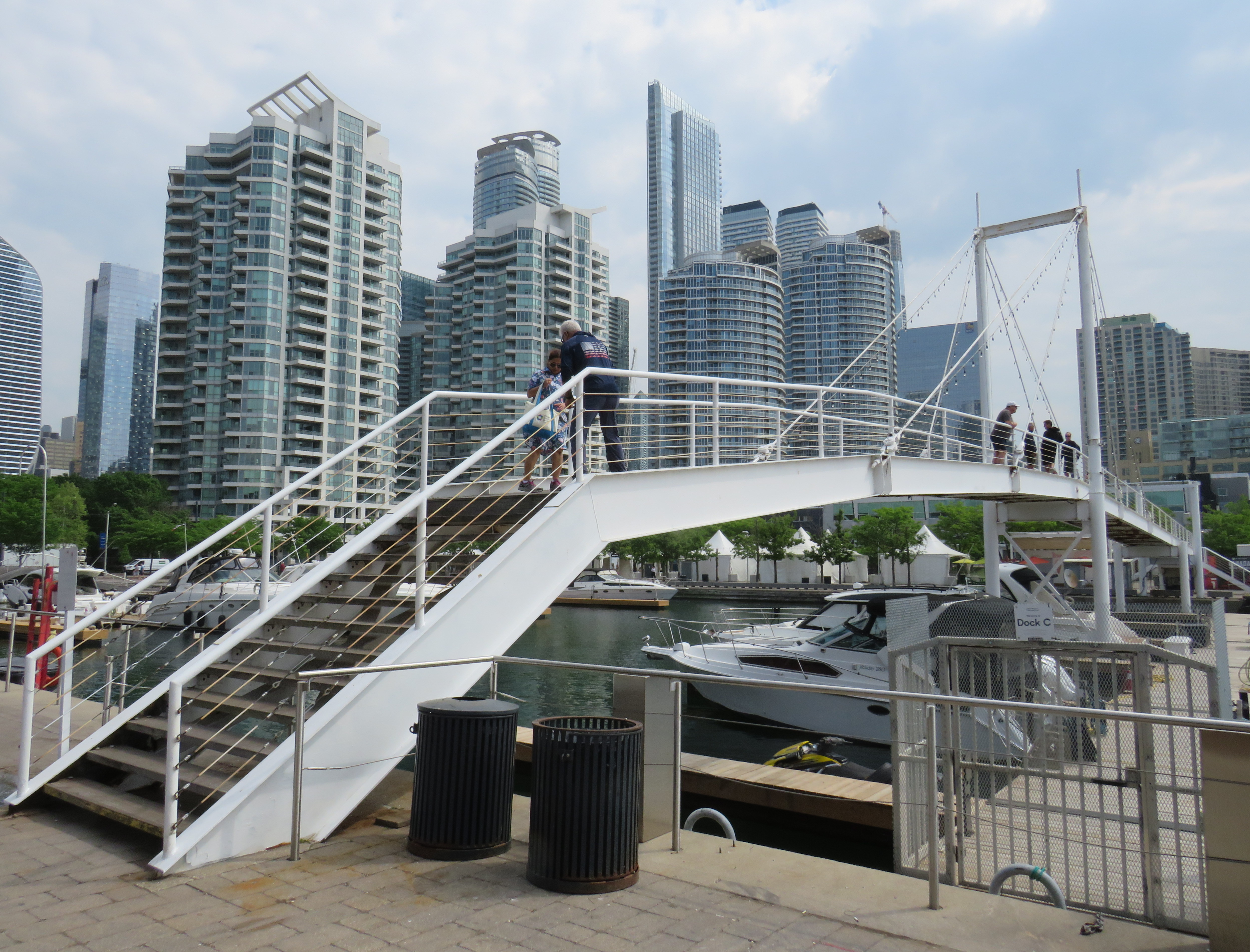
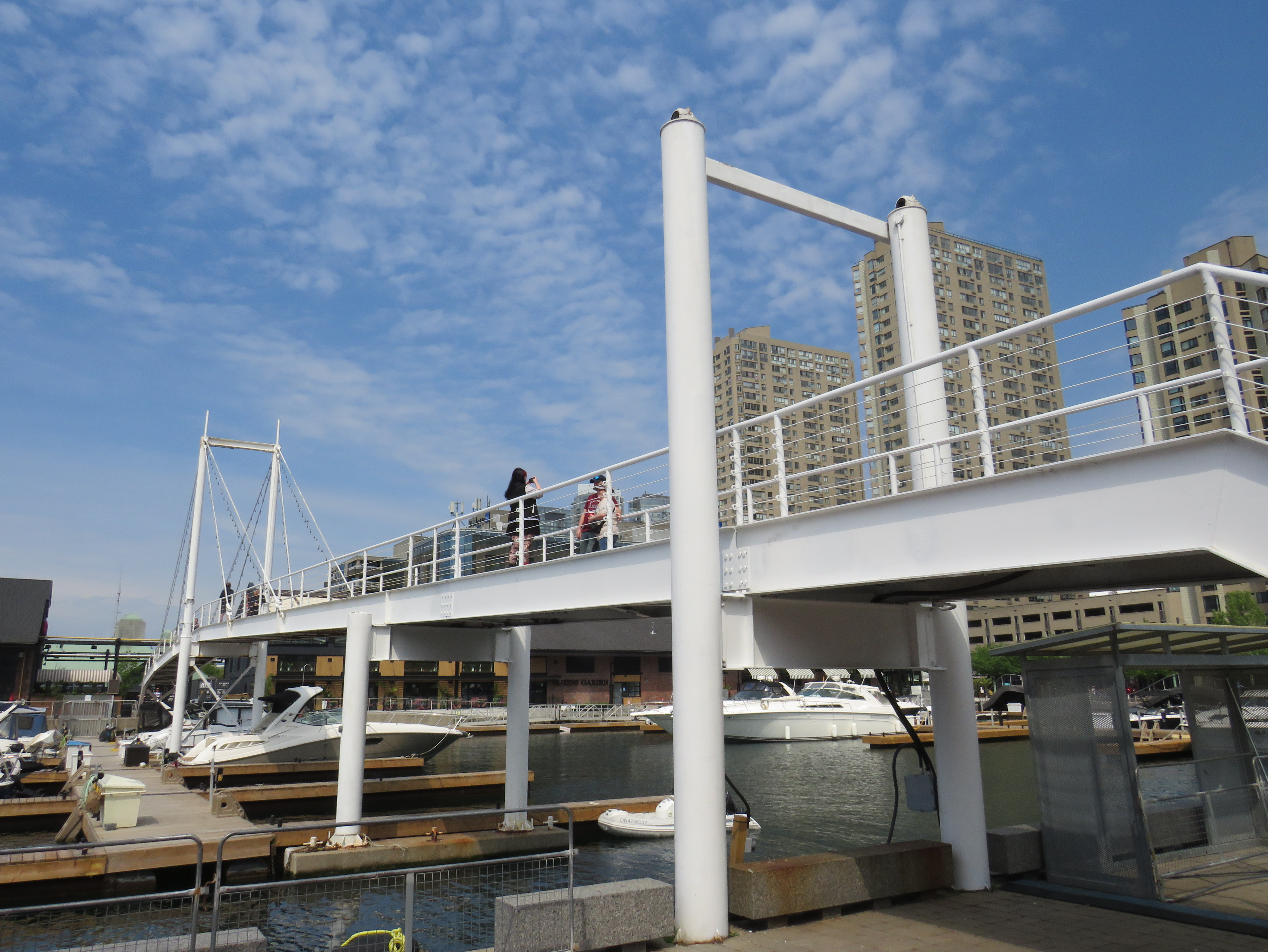
On Sunday, May 31, the Amsterdam Bridge reopened on Toronto’s Harbourfront after being closed for five years. The footbridge, which spans a marina south of Queen’s Quay, is a popular meeting place and photo opportunity, with views of Toronto Harbour to the south and the towering skyline to the north. A gift of the City of Amsterdam, one of Toronto’s sister cities at the time, the bridge was one of the first great public spaces on the waterfront as it was beginning to transition from a derelict industrial space to the city’s new front yard.
The Amsterdam Bridge in 2014
The footbridge, a cable suspension structure over the marina featured a lifting section on the east side so that tall yachts could moor at the north end of the marina on request, though this was not a regular occurrence. The design mimicked some of the iconic canal crossings in Amsterdam. Sadly, due to neglect, the bridge was closed to pedestrians in 2021 and the lifting section removed.
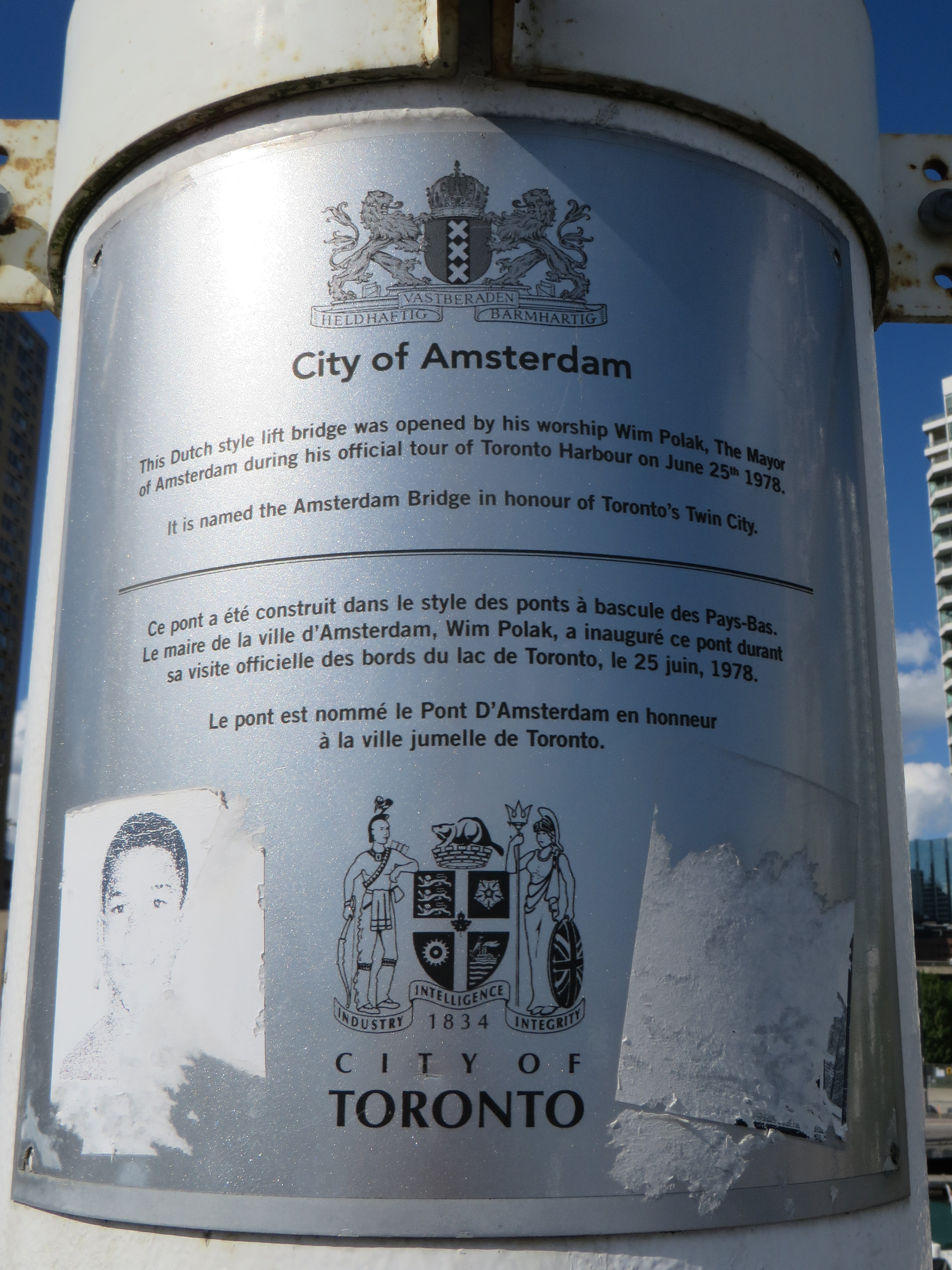
Plaque on the bridge commemorating the opening of the Amsterdam Bridge, a “Dutch style lift bridge” on June 25, 1978 by Amsterdam mayor Wim Polak, taken in 2014. Note the old pre-amalgamation City of Toronto coat of arms below. A replacement plaque with similar text (but with the current post-amalgamation civic coat of arms) since replaced the original.
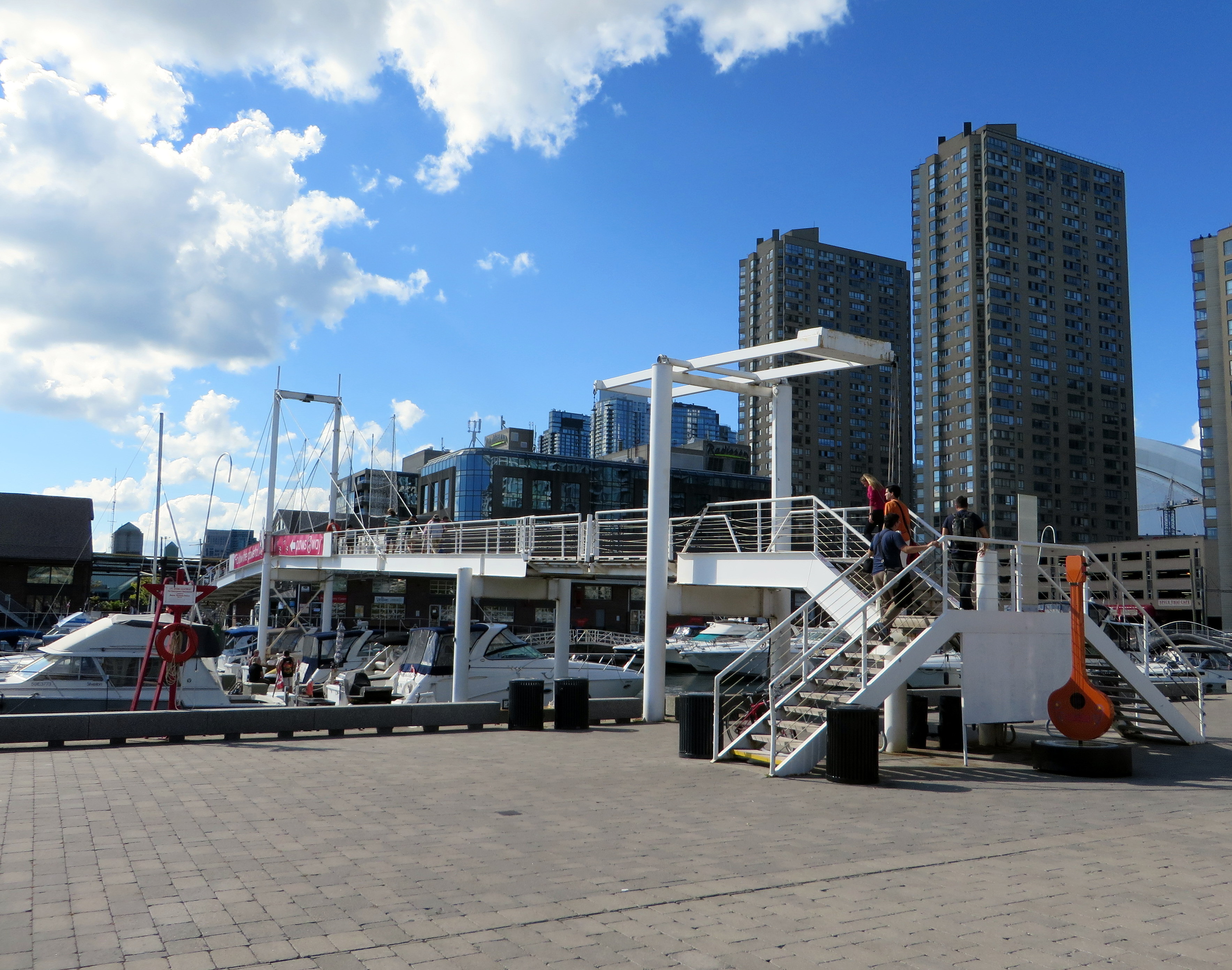
When the bridge reopened in 2026 just in time for Toronto hosting six World Cup soccer matches, the lifting section was replaced by a fixed span. Once again, visitors can climb the bridge, take in the views, and snap great photographs, but the “lift bridge” of the original “Dutch style lift bridge” is no more. It’s a shame too, that it took five years for this fix to even happen; Toronto needs to do better at maintaining its public assets, especially its unusual, fun, and quirky landmarks.
Fixed deck on the Amsterdam Bridge in 2026
Around the same time Toronto got an Amsterdam Bridge, the City of Amsterdam named a bridge for Toronto. The Torontobrug spans the Amstel River, carrying the busy Centrumring (Central Ring Road). A five-lane traffic artery outside the major tourist areas, the bridge is not iconic by any means (I biked to it during my 2013 visit to Amsterdam) but it is an important road link. There are separated cycle tracks on both sides of the bridge, so it is at least multimodal. The bridge can still open for river boat traffic when necessary.
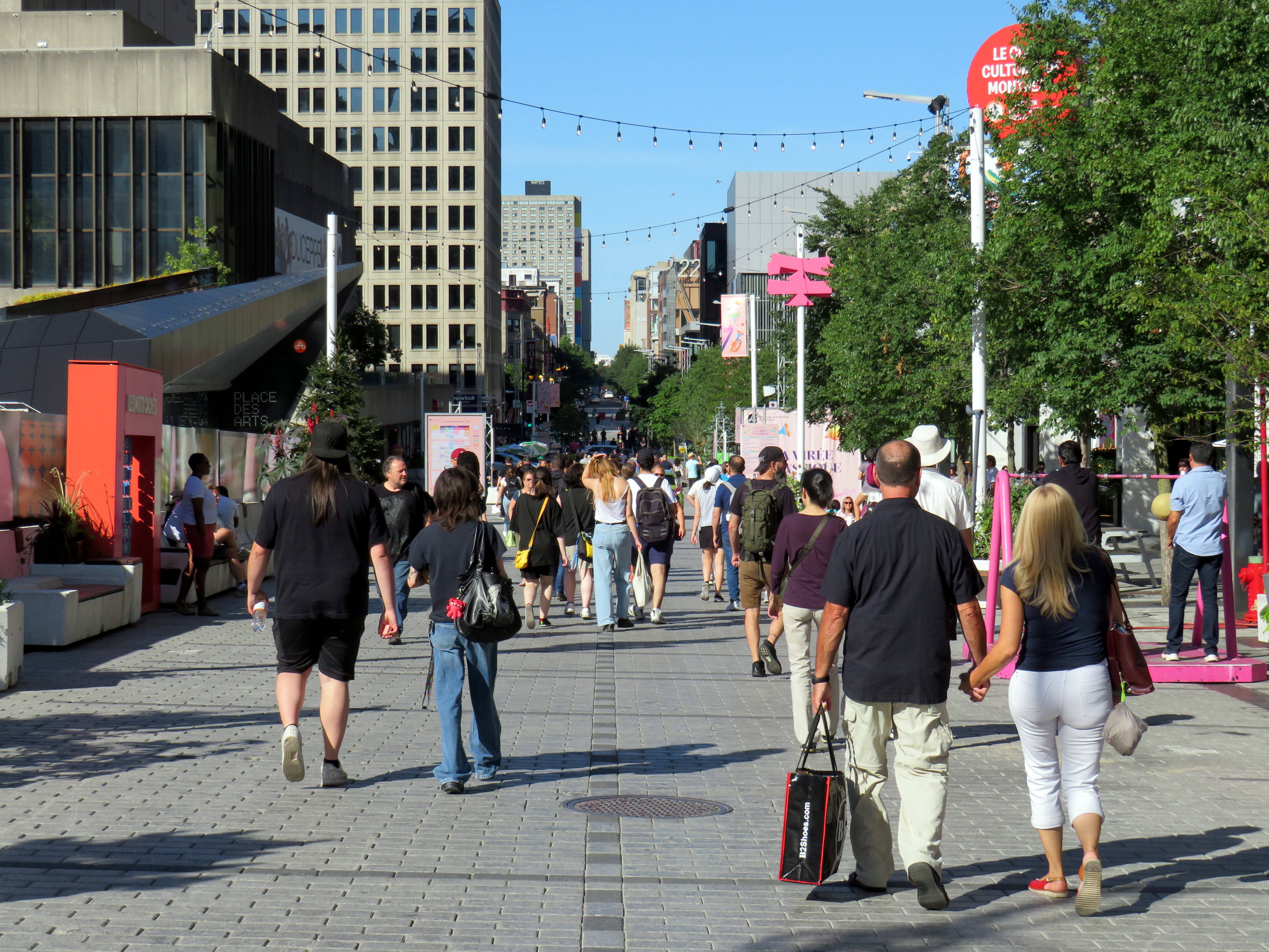
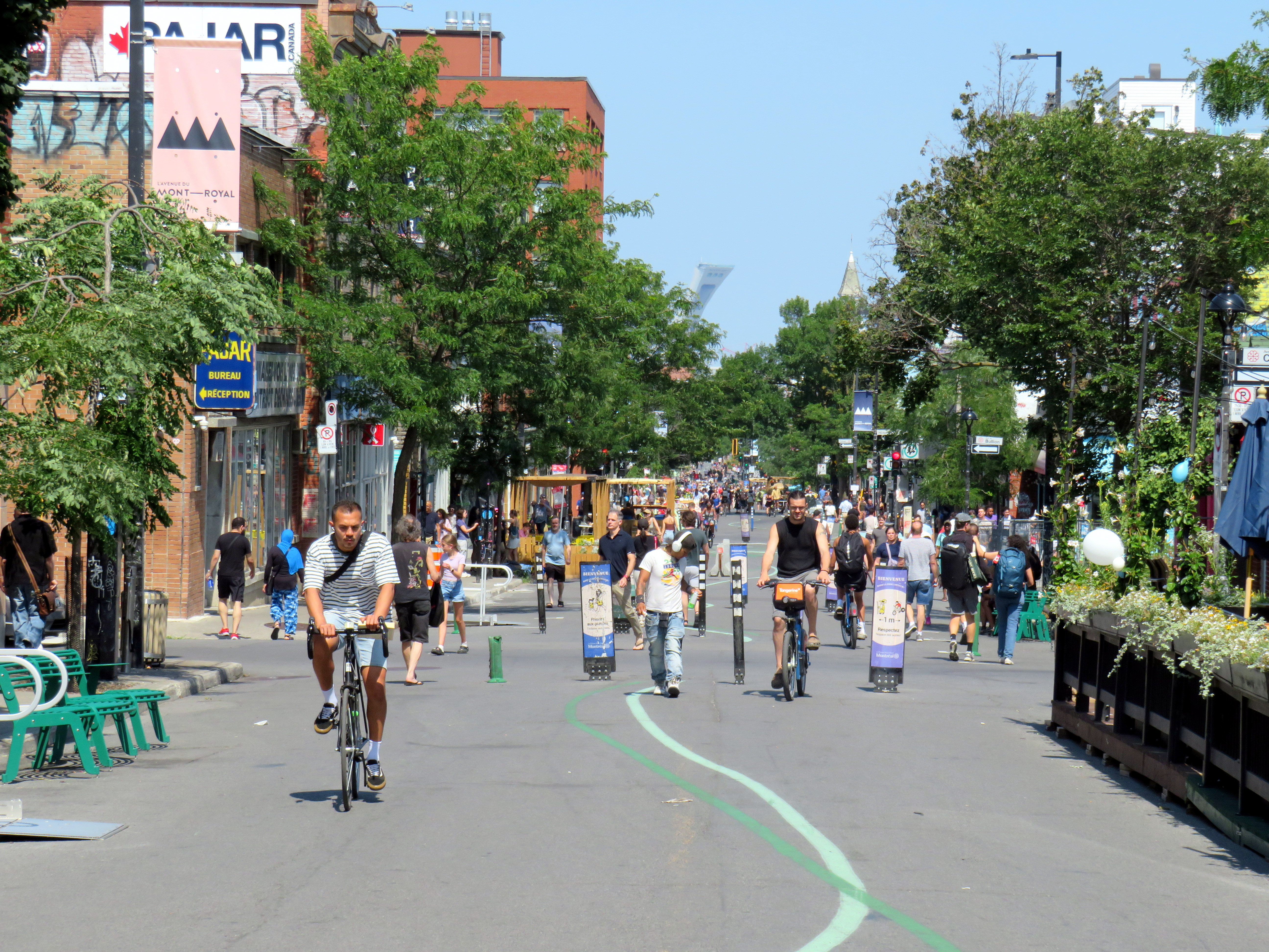
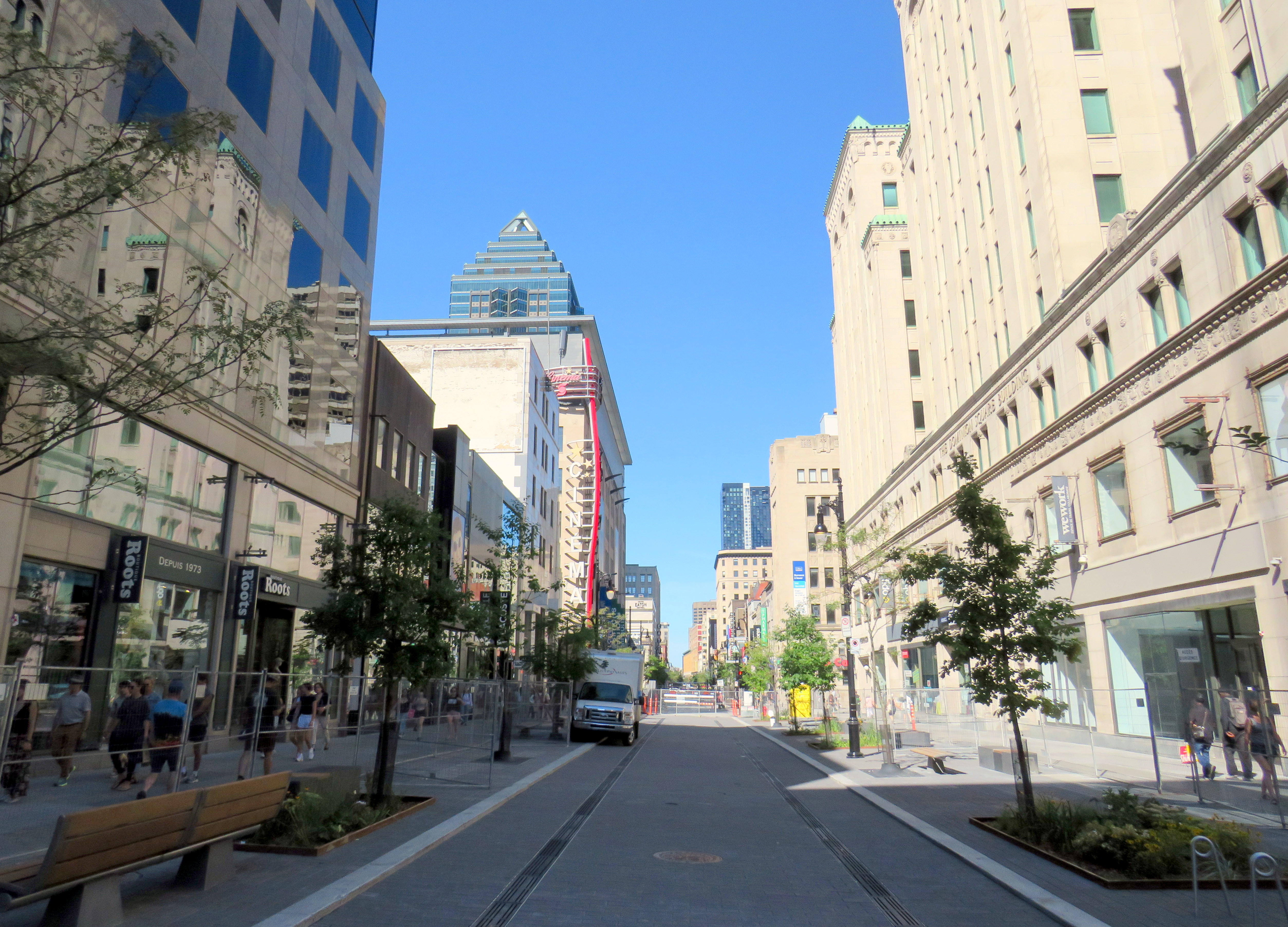
Rue St-Catharine in the Quartier des Spectacles, August 2025
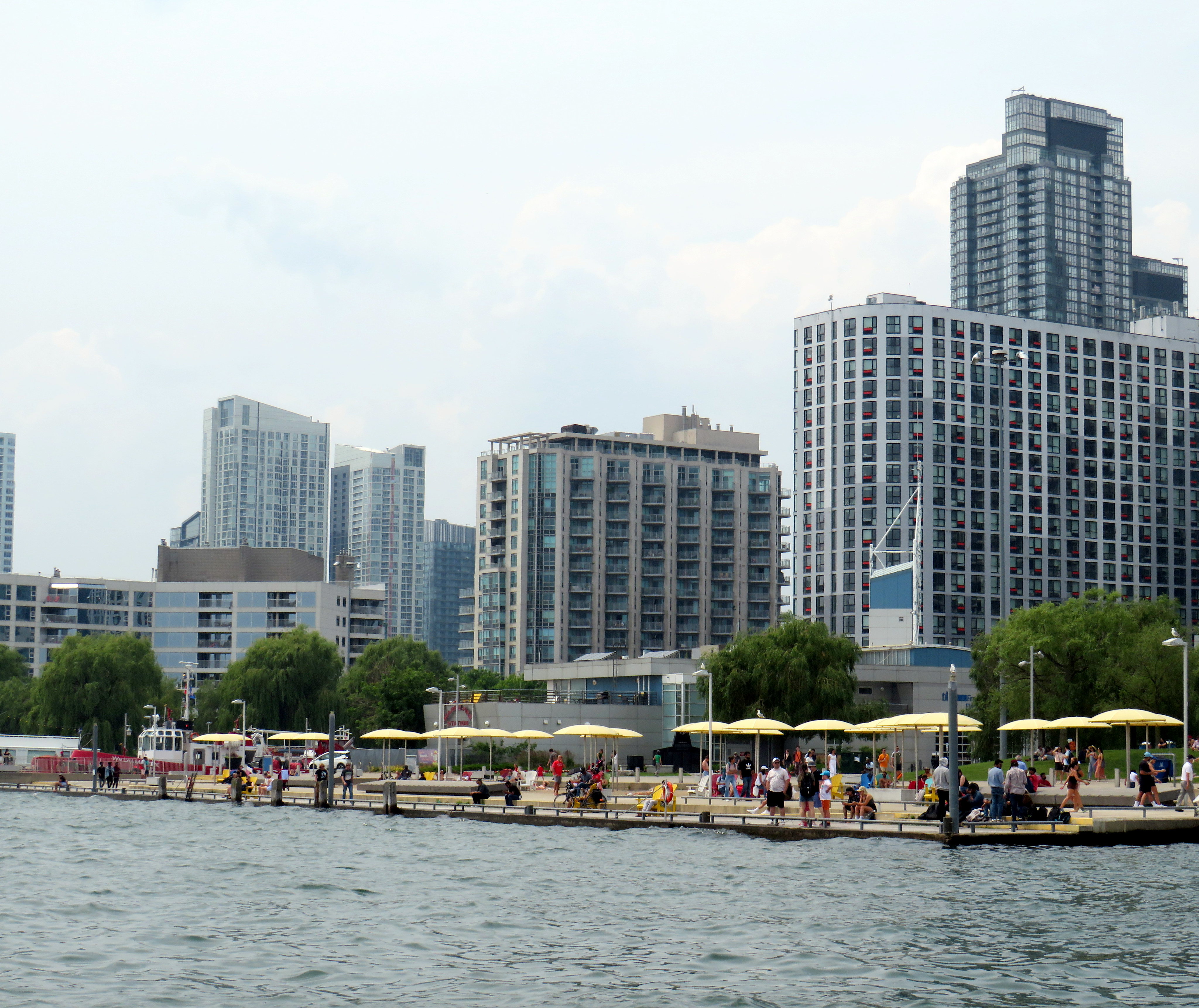
A visit to Montreal can make one jealous. Jealous of the city’s better street furniture, greater cycling infrastructure, great public spaces throughout the city, and an improved pedestrian realm. Entire streets are closed in the summer months to motor traffic, allowing pedestrians to spill out into the roadway, and patios to sprout without the need for concrete blocks to protect them (and less noise and pollution to those dining al fresco).
For example, Avenue Mont-Royal, was first closed in Summer 2020 as a “Corridor Sanitare” to encourage people to get outside during the first wave of the COVID-19 pandemic and support local businesses, which set up patios on the sidewalk and the street. My spouse and I rented a car and visited Montreal during this time, getting a lot of walking in a city that opened up as much as safely possible.
Avenue Mont-Royal, looking east, August 2020
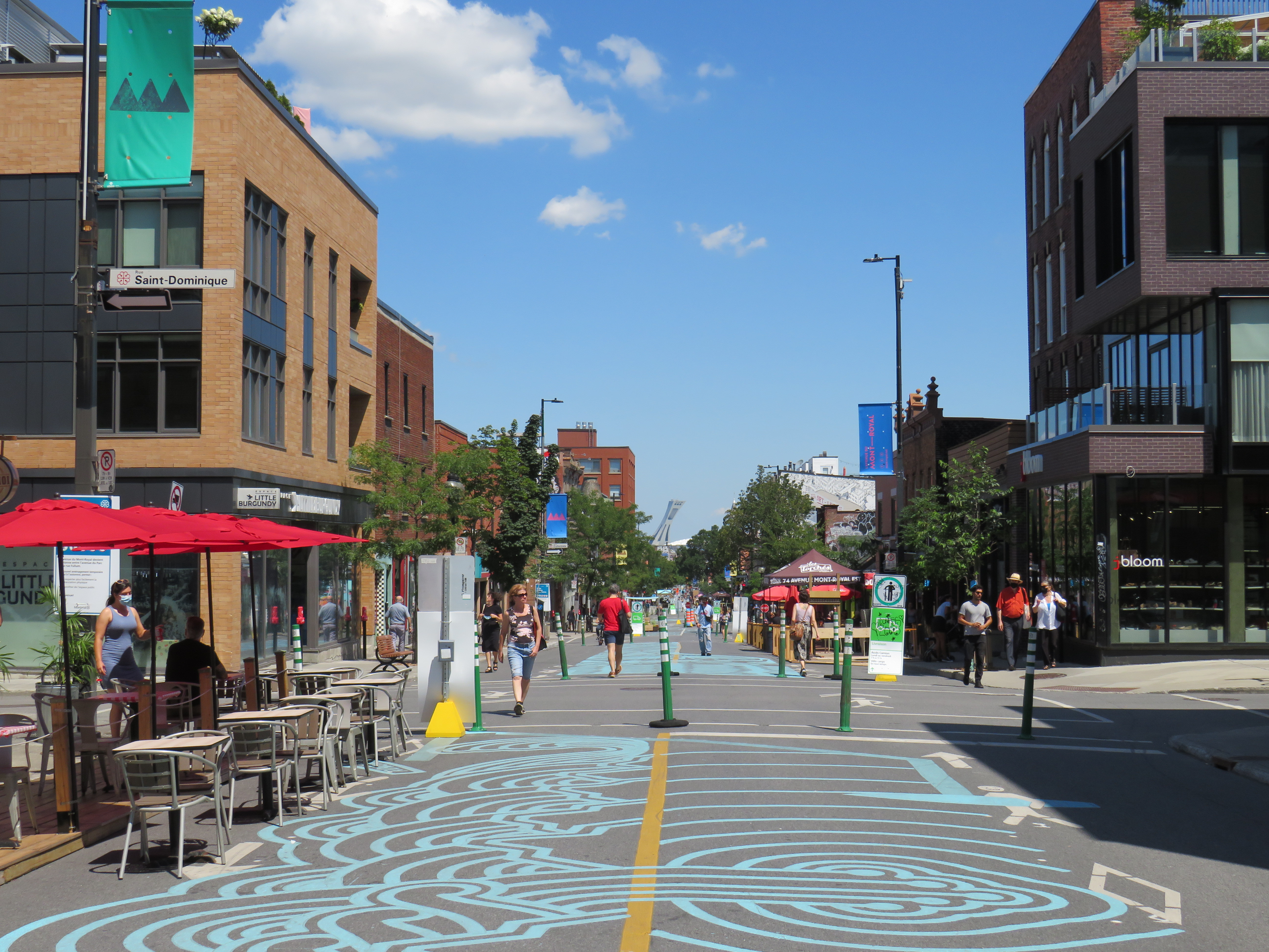
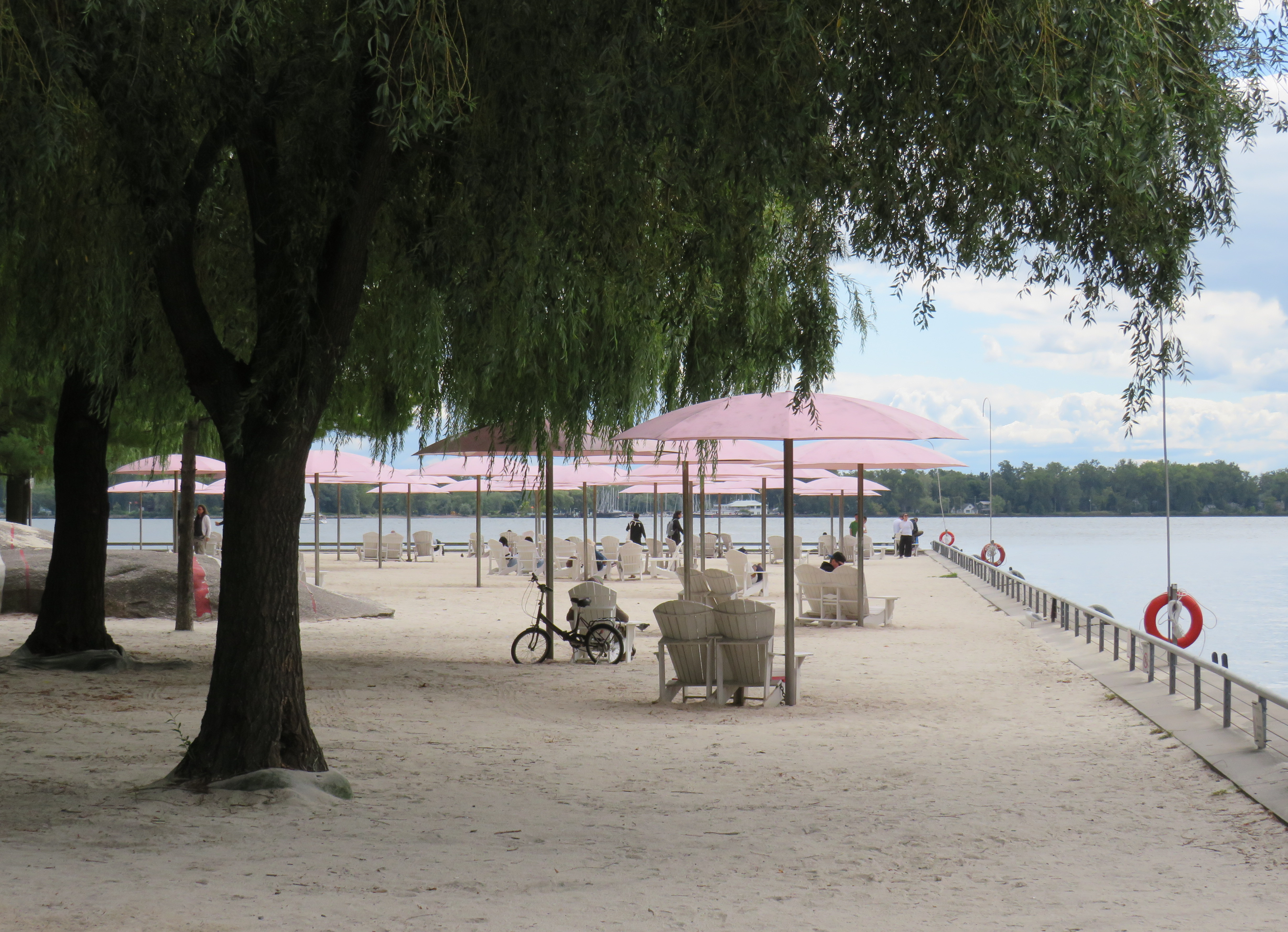
Happily, Montreal continued the tradition in the years since, even as pandemic restrictions eased, then disappeared entirely. Five years later, Avenue Mont-Royal was even more vibrant. Not only were there lots of patios on the street, there were public benches, shade structures, and water fountains, allowing anyone to sit, relax, and enjoy the outdoors. The annual summer closure is a hit.
Avenue Mont-Royal, looking east, August 2025
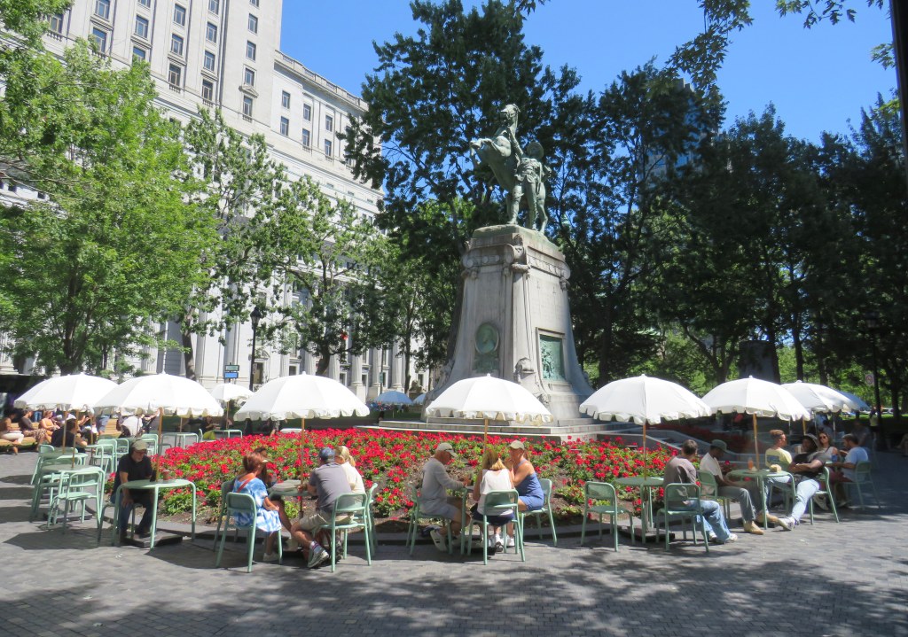
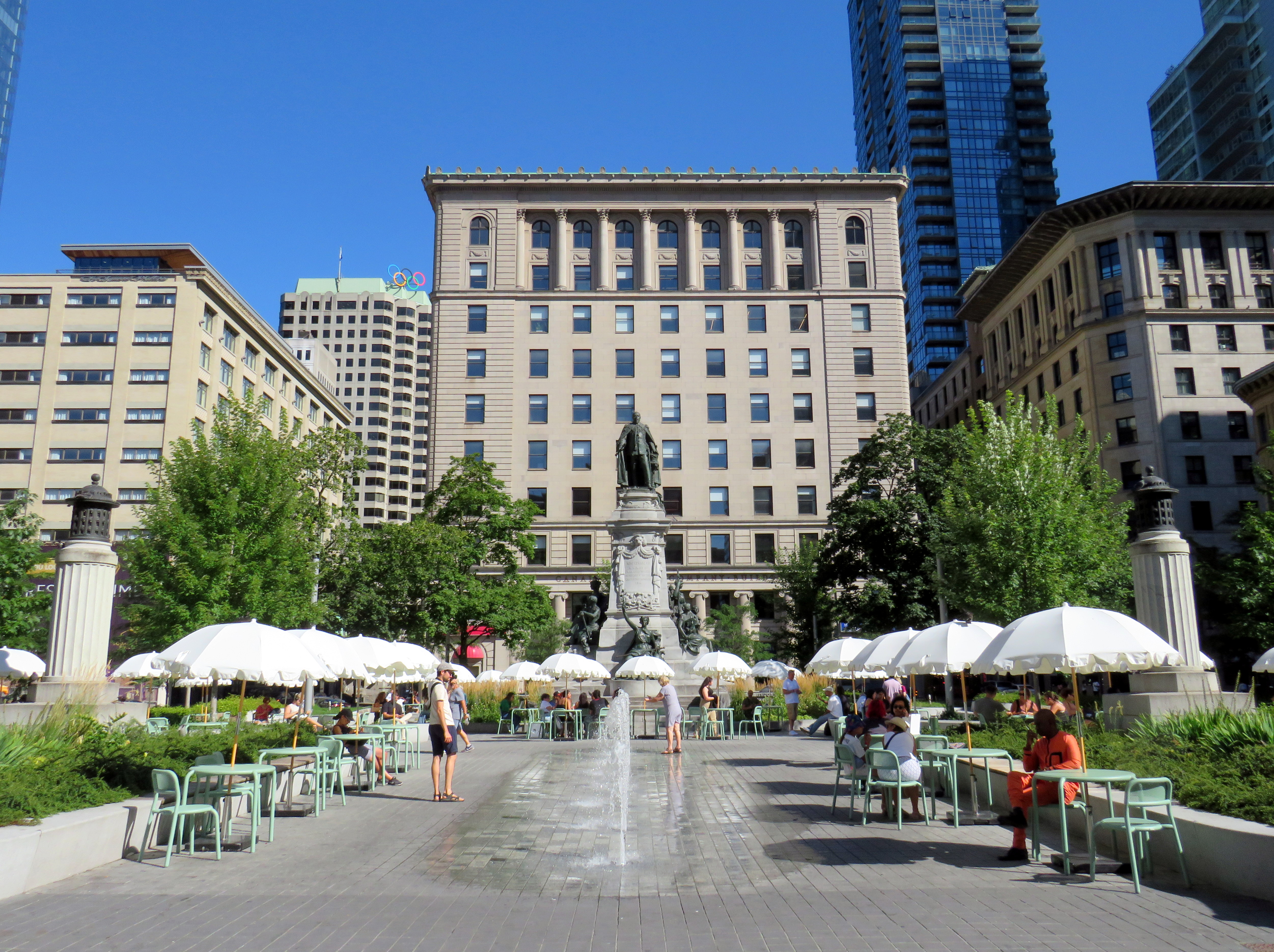
Several public squares were also renewed in recent years. Phillips Square, on Rue Ste-Catharine across from the now-shuttered Hudson’s Bay department store, was renewed with new splash fountains along with small café-style tables and chairs, complete with shade umbrellas. The metal chairs are movable, allowing larger groups to sit around a single table. It’s a refreshed natural congregation point along the city’s main shopping street.
Phillips Square, August 2025
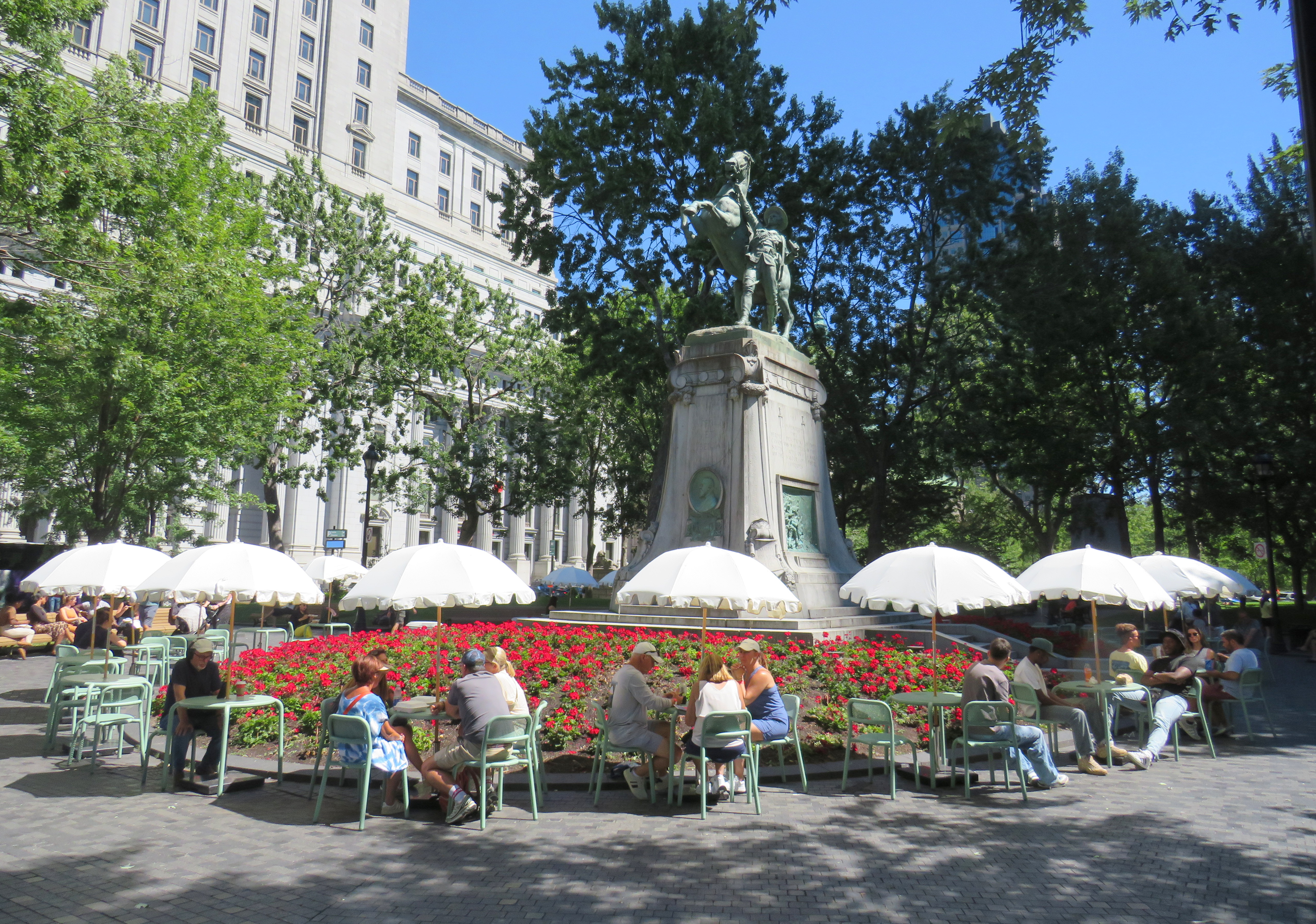
Similar tables and umbrellas were set up at Dorchester Square, several blocks to the west, near Mary, Queen of the World Cathedral and Central Station. Both squares were reimagined by the brilliant landscape architecture firm Claude Cormier + Associés. At Dorchester Square, a new water fountain, seemingly a classic installation, is cut in the rear, with a woodpecker behind. Such Easter eggs are features of Cormier park projects.
Dorchester Square, August 2025Fountain at Dorchester Square; note the woodpecker on the side. One of the two black curved footbridges across the parking ramps is behind.
Furthermore, Montreal is rebuilding the western section of Rue St-Catharine towards Crescent. Though motor vehicles are permitted after reconstruction, they are limited to a single through lane, with lay-bys for deliveries, passenger pick-ups and drop-offs, and emergency vehicles. Sidewalks are widened considerably, with more benches, bicycle parking, and street trees.
Completing Rue St-Catharine, near Bishop Street
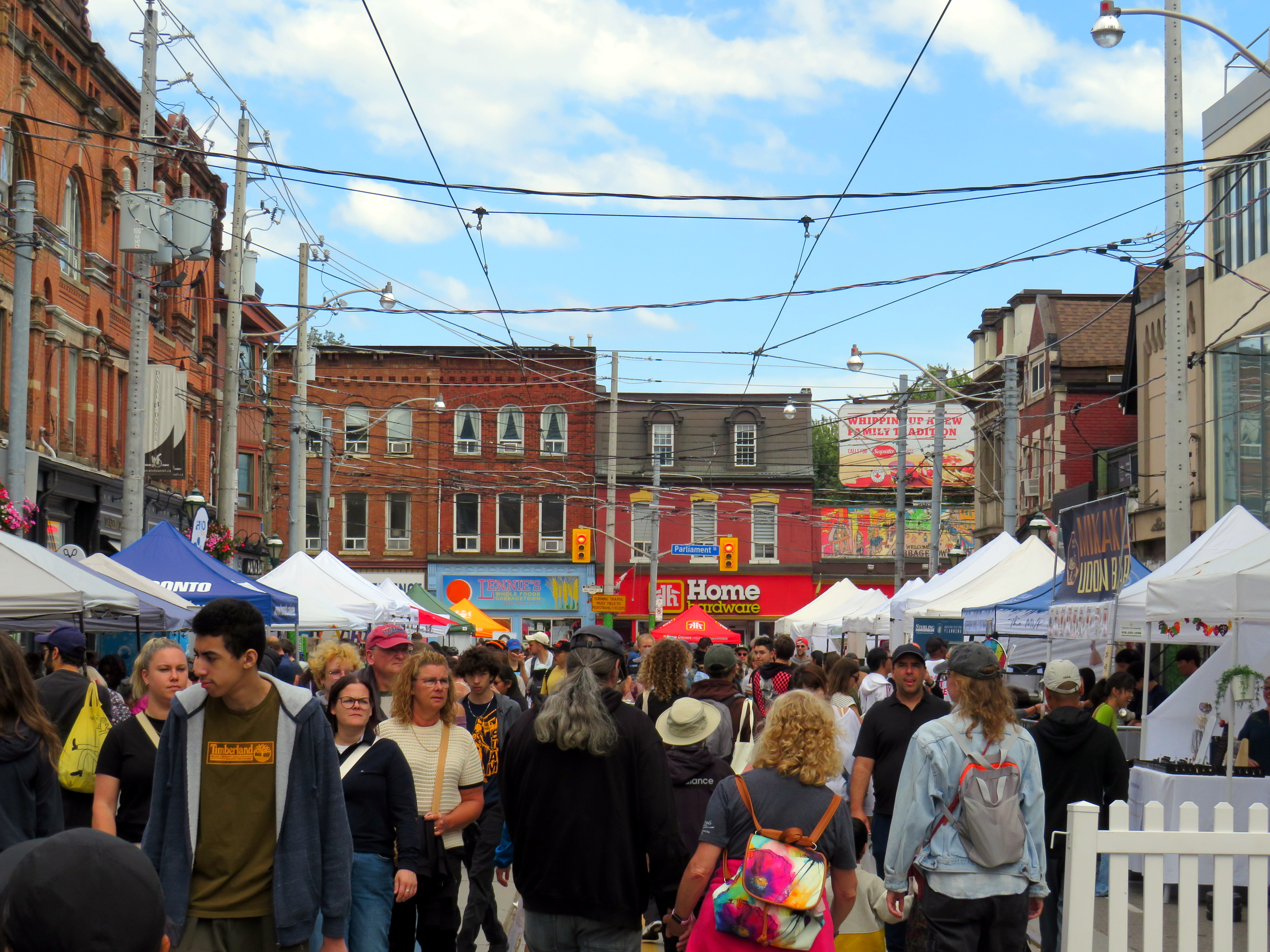
After returning to Toronto, it’s easy to feel down on this city. Montreal seems to do everything right. Meanwhile, ActiveTO, the open streets initiative following the pandemic restrictions here, quickly eroded, and was effectively ended in 2022. Open Streets, which closed sections of Yonge and Bloor Streets to motorists for two Sunday mornings, was last held in 2022. But there are still business improvement area-led weekend street festivals, which attract tens of thousands of pedestrians.
Torontonians want to walk, and pedestrianized streets, even when they’re just weekend events, are immensely popular. One downside, however, is a lack of seating outside of businesses’ patio areas. One is free to walk, enjoy live music, or just people watch, but to sit down, one is compelled to purchase something from one of the businesses with a sanctioned patio.
Torontonians love a street festival: Cabbagetown in September
There are a few other successes. A small segment Gould Street at Toronto Metropolitan University was pedestrianized and rebuilt as a central plaza for that university campus. A short section of Willcocks Street at the University of Toronto was similarly pedestrianized.
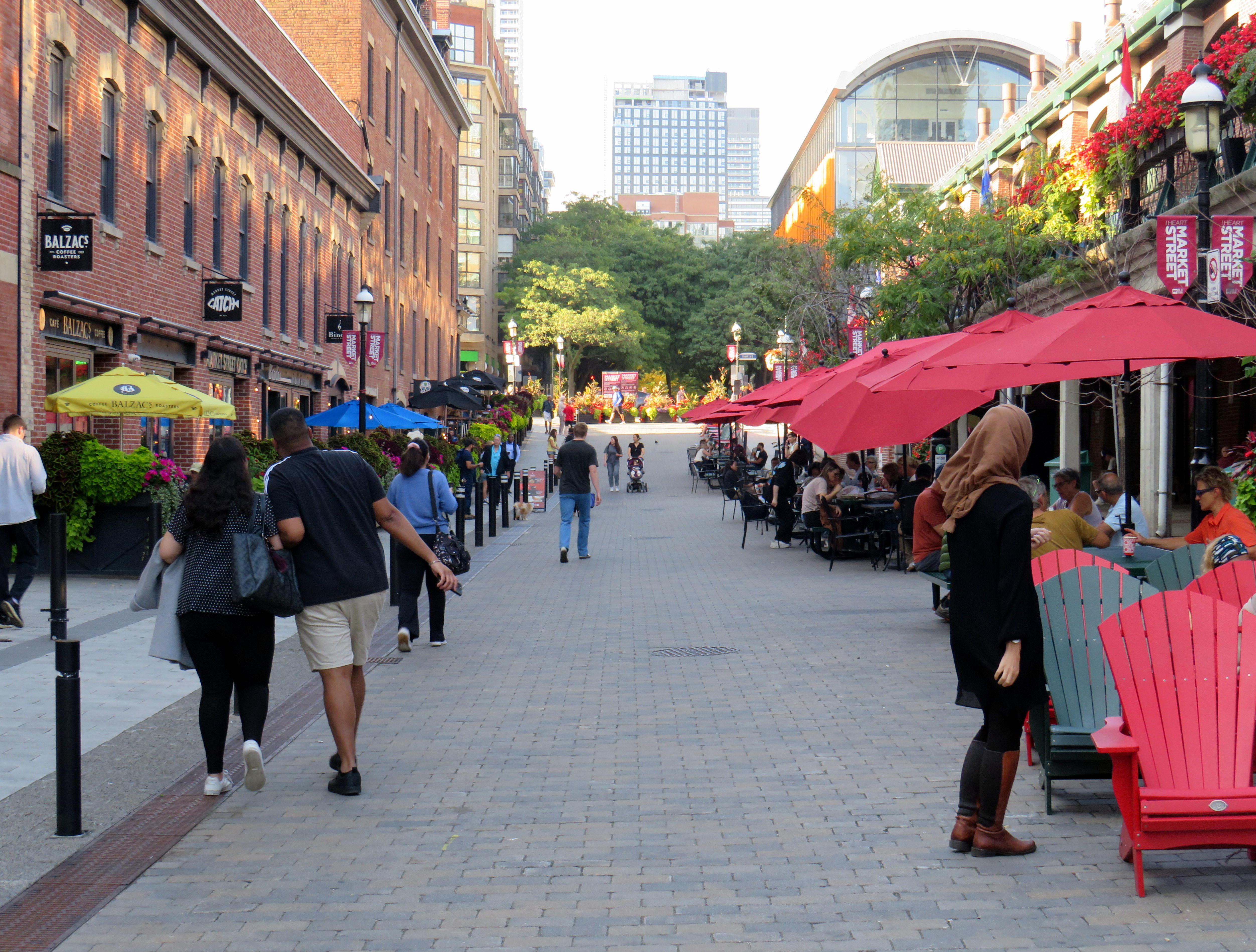
But the best example in Toronto is Market Street, which abuts St. Lawrence Market. Patio space and Muskoka chairs provide plenty of seating, without obligation to purchase anything (though it provides additional seating to those who picked up a snack or lunch inside the market). The shade umbrellas and high-quality surface materials and street furniture make this a wonderful oasis in Toronto’s downtown core.
Market Street looking north from The Esplanade. St. Lawrence Market is on the right.
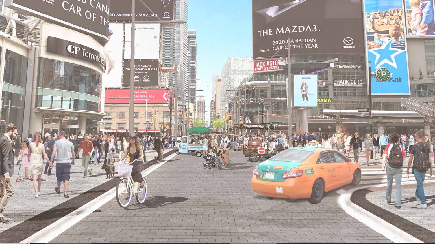
Planning for Yonge Street’s makeover, which will include narrowing the roadway, widening the sidewalks, improvements to the public realm, and seasonal closures of selected sections of the traffic lanes, is complete. Unfortunately, the YongeTOmorrow improvements will have to wait for another five years (work starting in 2030) due to Ontario Line construction.
Rendering of Yonge Street looking north towards Dundas, once YongeTOmorrow improvements are complete
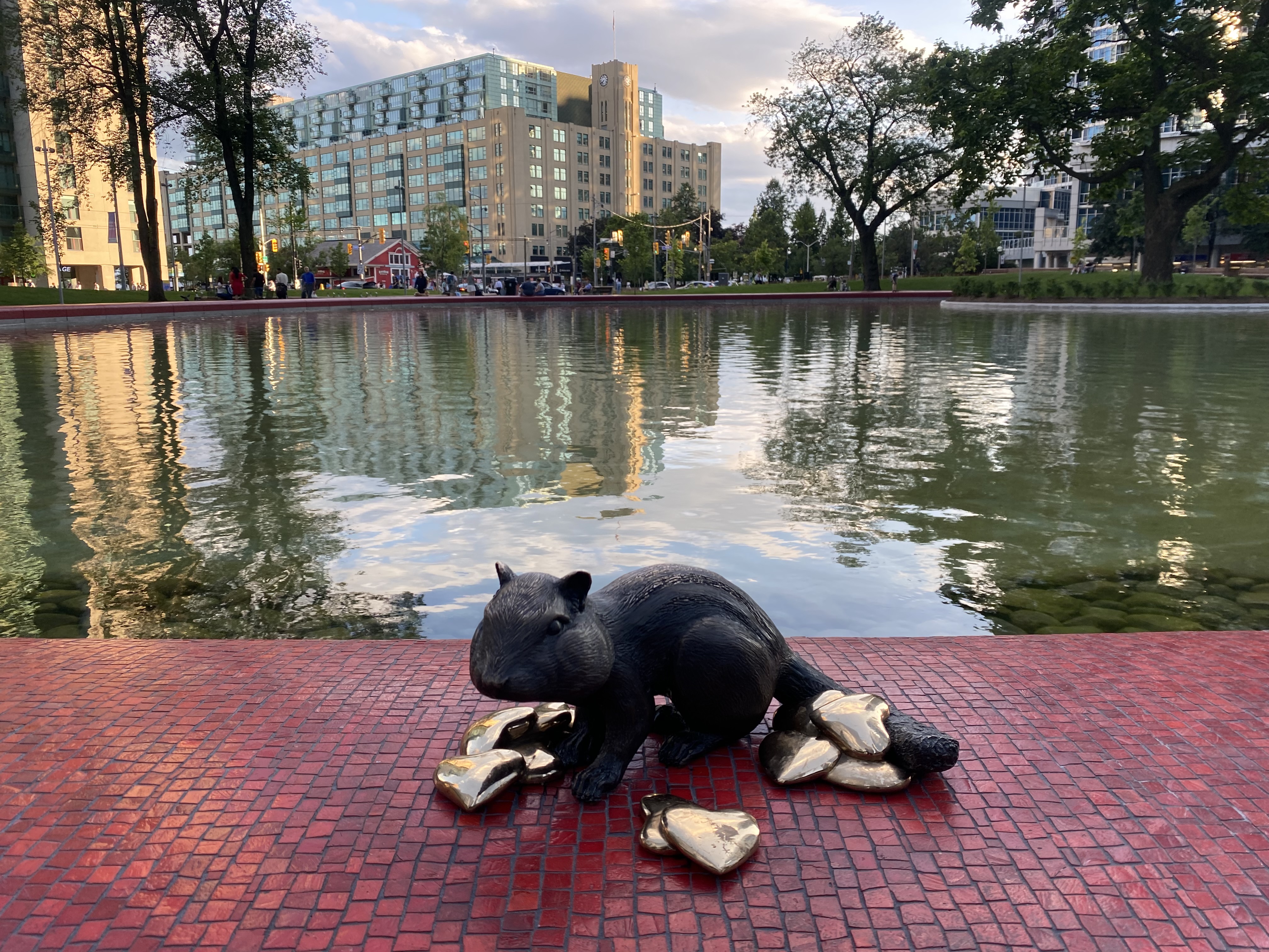
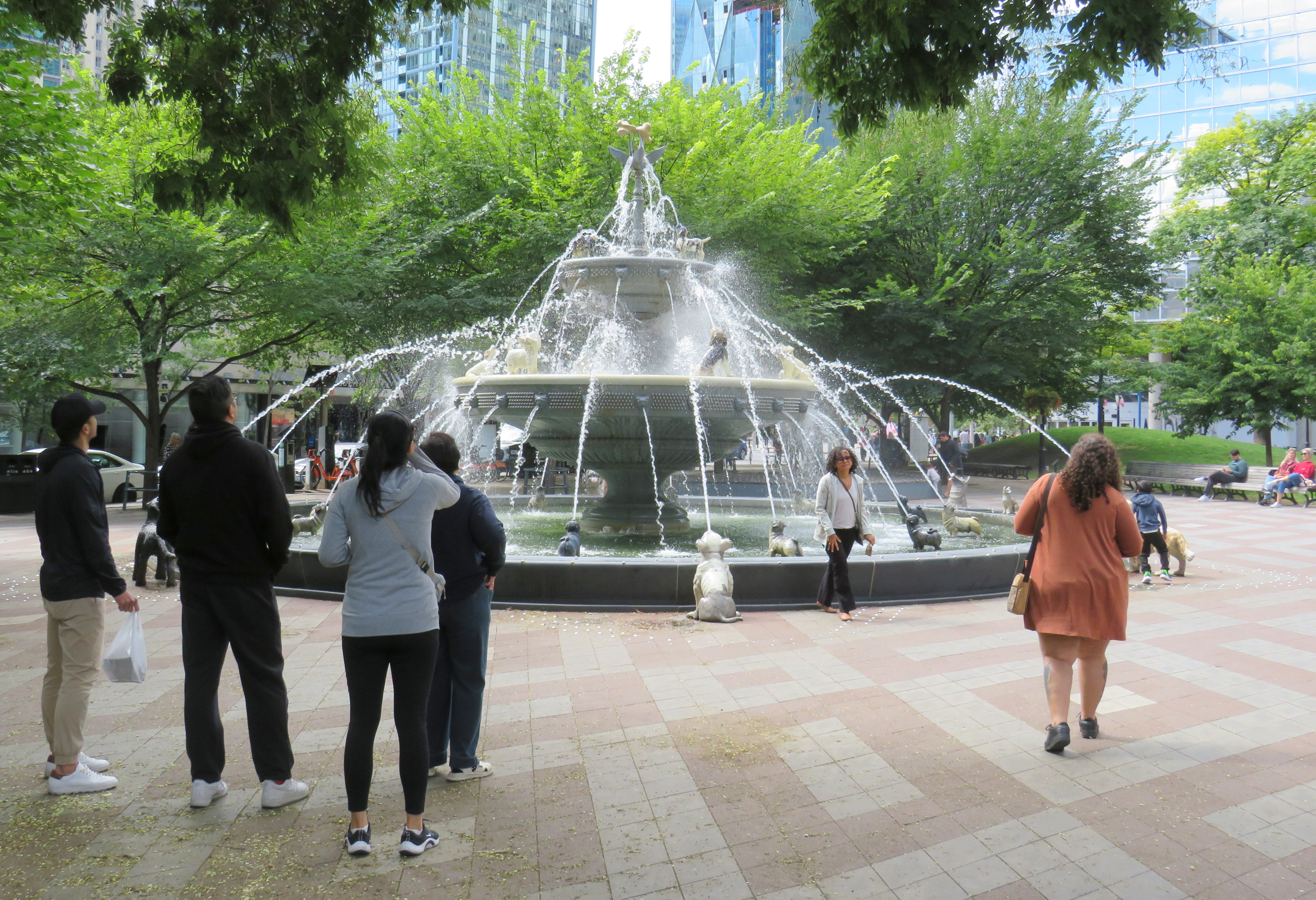
There are also other great things happening in Toronto. Claude Cormier was tapped to create new public spaces, such as HtO Park and Sugar Beach on the Harbourfront, but also reimagine existing places such as Love Park (previously a highway off-ramp) and Berczy Park, home of the popular Dog Fountain. At Love Park, not one of the 45 movable chairs have been taken (though one ended up in the pond). Torontonians have been shown to cherish great public spaces.
HTO Park from Toronto Harbour
Canada’s Sugar Beach
Love Park
Berczy Park
Toronto has made a lot of progress on improving its public realm, and it has shown that it is willing and able to close streets to traffic for the benefit of pedestrians and cyclists. Though it is so very easy to envy Montreal for its greater progress in the last two decades, it is up to us to continue the momentum Toronto does have, and work harder to push for change, even when there’s a car-focused provincial government. Streets can be narrowed, parks can be improved, and streets can be handed over to the people. Additional seating and more public washrooms will open up this city to many more residents and visitors.
This should all be a key pillar of a progressive agenda in next years’ municipal election. When certain candidates talk about tax cuts, austerity, and crime, there needs to be a focus on creating a better quality of life to provide an alternative. And that talk must be backed up with action, with quick wins that don’t require multi-year waits.
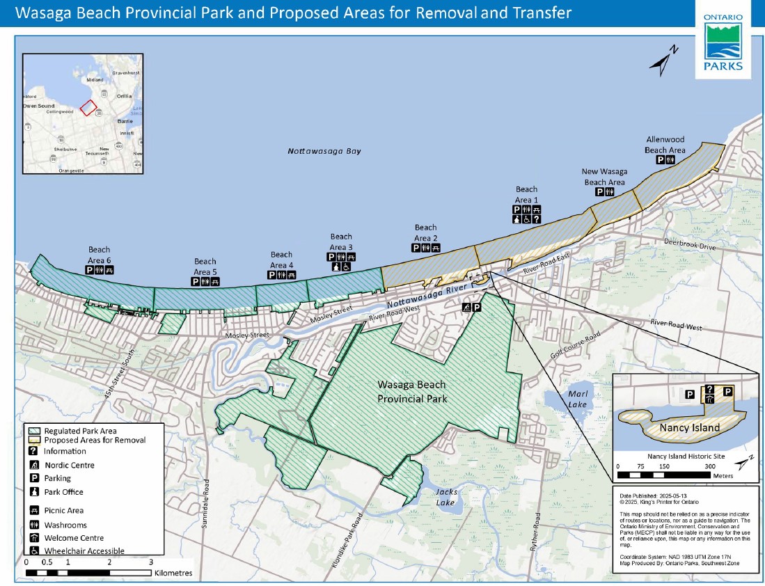
In late July, online news outlet PressProgress reported on the provincial government’s plans to divest itself of 60 percent of the beach areas of Wasaga Beach Provincial Park, transferring the waterfront lands to the Town of Wasaga Beach. This report raised a number of concerns, including environmental issues (the beach is an important habitat for the piping plover, an endangered species of shorebird which breeds on sandy shorelines), as well as continued public access to the world’s longest freshwater beach. By amending legislation to transfer these lands from provincial to local control without future votes in the legislature, future provincial park lands could also be sold off to municipalities or to the private sector.
Wasaga Beach Provincial Park and proposed areas for removal and transfer to the municipality
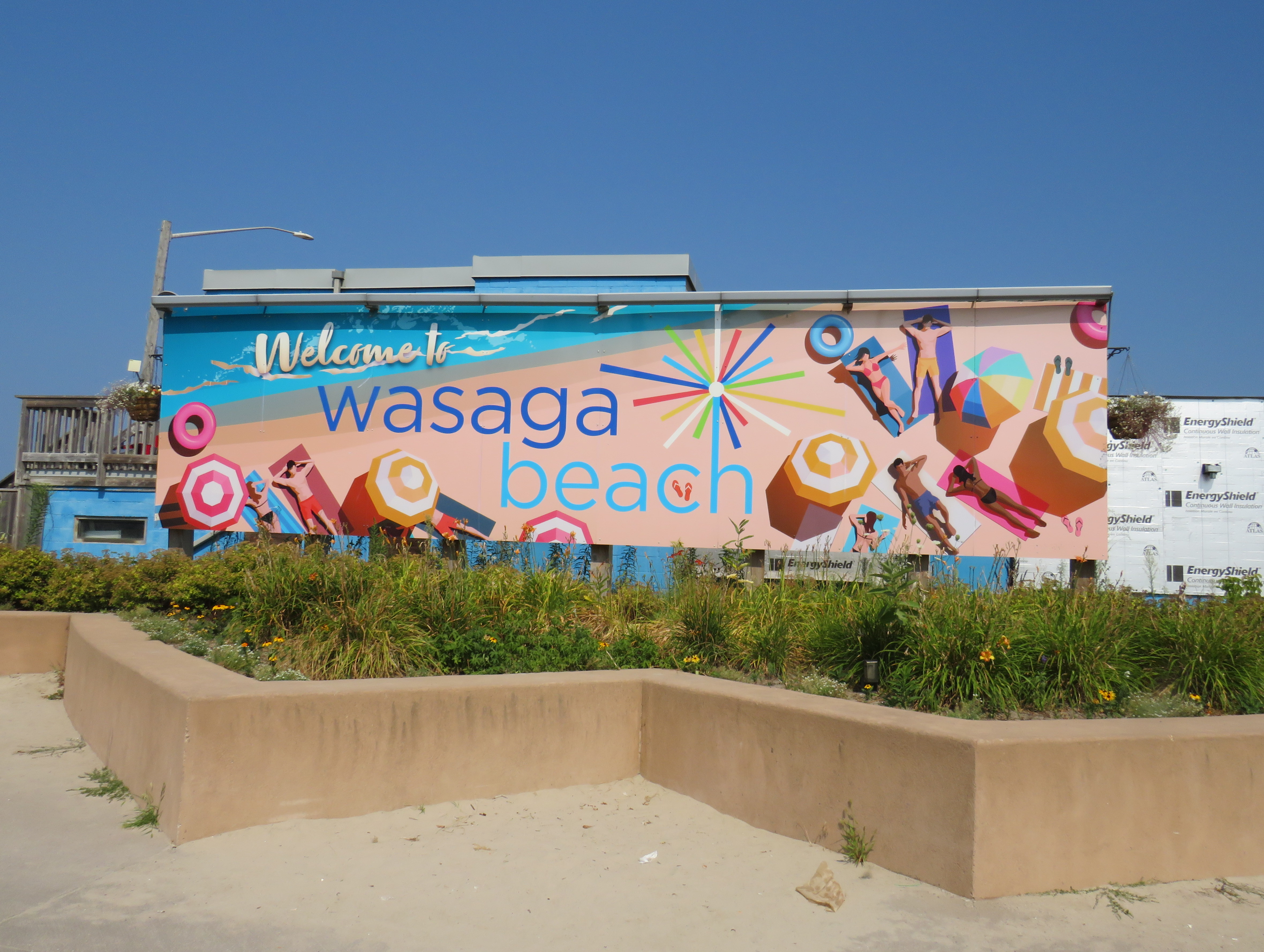
Sign touting provincial funding for Wasaga Beach’s beachfront redevelopment
Amending the Act to permit the divestment of protected lands is a bad precedent, though arguably it was already set by the privatization of much of Ontario Place for the troubled Therme spa development. The closed Ontario Science Centre grounds remain in limbo as well.
As Shawn Micallef recently pointed out in the Toronto Star, much of Ontario’s prime lakefronts are privatized or purposely made inaccessible to outside residents — not just the popular Muskoka Lakes, but also much of the Great Lakes shores, such as in Tiny Township near Midland. The big, popular, beach areas are worth preserving and expanding, not only to meet current demand, but also provide sustainable and affordable getaways for a growing population in Southern Ontario.
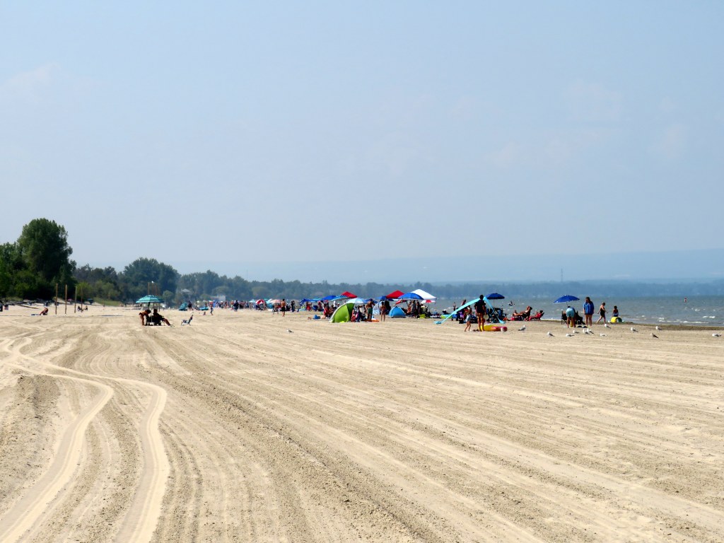
The beautiful sand at Wasaga Beach Provincial Park on Thursday, August 14
That demand for summer lake access brings up another challenge — how to get people to and from beach destinations. In Toronto, the lineups for the Island ferries are notorious in the summer. The compound where ferry-goers are forced to wait only adds to the inhospitable atmosphere, though temporary shade structures were added for 2025. The beach at Ontario Place, one of the cleanest on Lake Ontario, has been closed off for the controversial Therme spa construction.
For those living in Toronto’s suburbs, or anyone looking to avoid the downtown congestion, to get to a good beach will probably mean a road trip to somewhere like Wasaga Beach, Sauble Beach, Grand Bend, Port Dover, Long Point, or Prince Edward County. Many of these places are completely inaccessible without a car, or at best, have limited bus options. Furthermore, even where there is a transit link, the best beach areas are nowhere near where the bus or train makes its stops. Even though Brampton is a straight shot up Airport Road to Georgian Bay, driving is the only reasonable way to get to Wasaga Beach (as I will get into in the second half of this post).
Right now, Wasaga Beach and Collingwood – a four-season resort town – are connected to Toronto, Barrie, and elsewhere only by two-lane roads: Highway 26, Airport Road, and Sunnidale Road. These roads are often congested with both visitors and with regular traffic. Highway 400 up to Barrie is already being widened, but it too will face additional traffic from population growth in Simcoe County and additional leisure travel.
If Wasaga Beach goes ahead and develops transferred provincial parklands for more intensive economic development, it will have to contend with these transportation challenges. That will mean wider roads and new highways, improved transit links, or both.
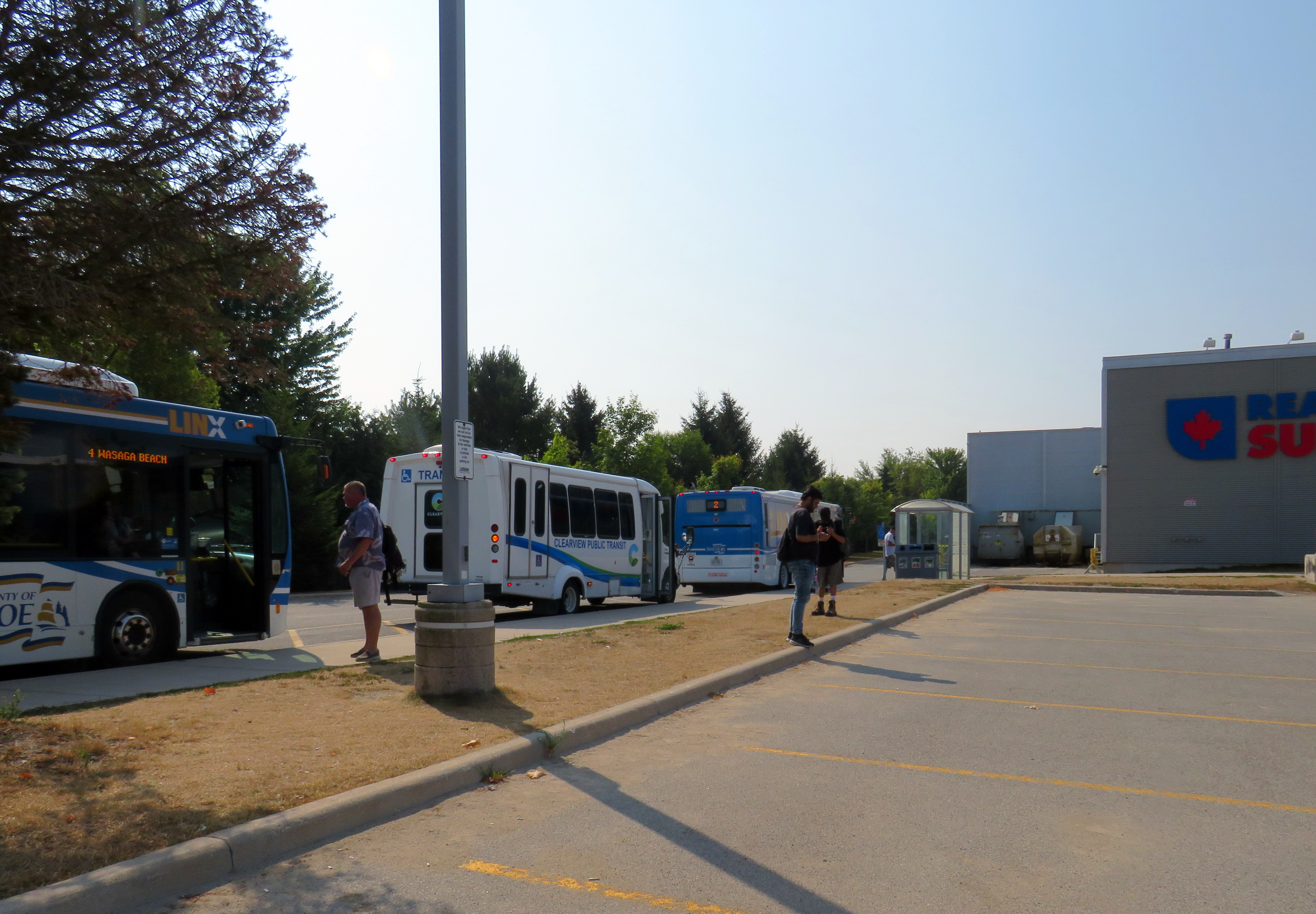
Local and regional buses behind a Loblaws superstore parking lot in Wasaga Beach
The way to Wasaga
There are currently two ways of getting to Wasaga Beach without a personal vehicle or a taxi ride.
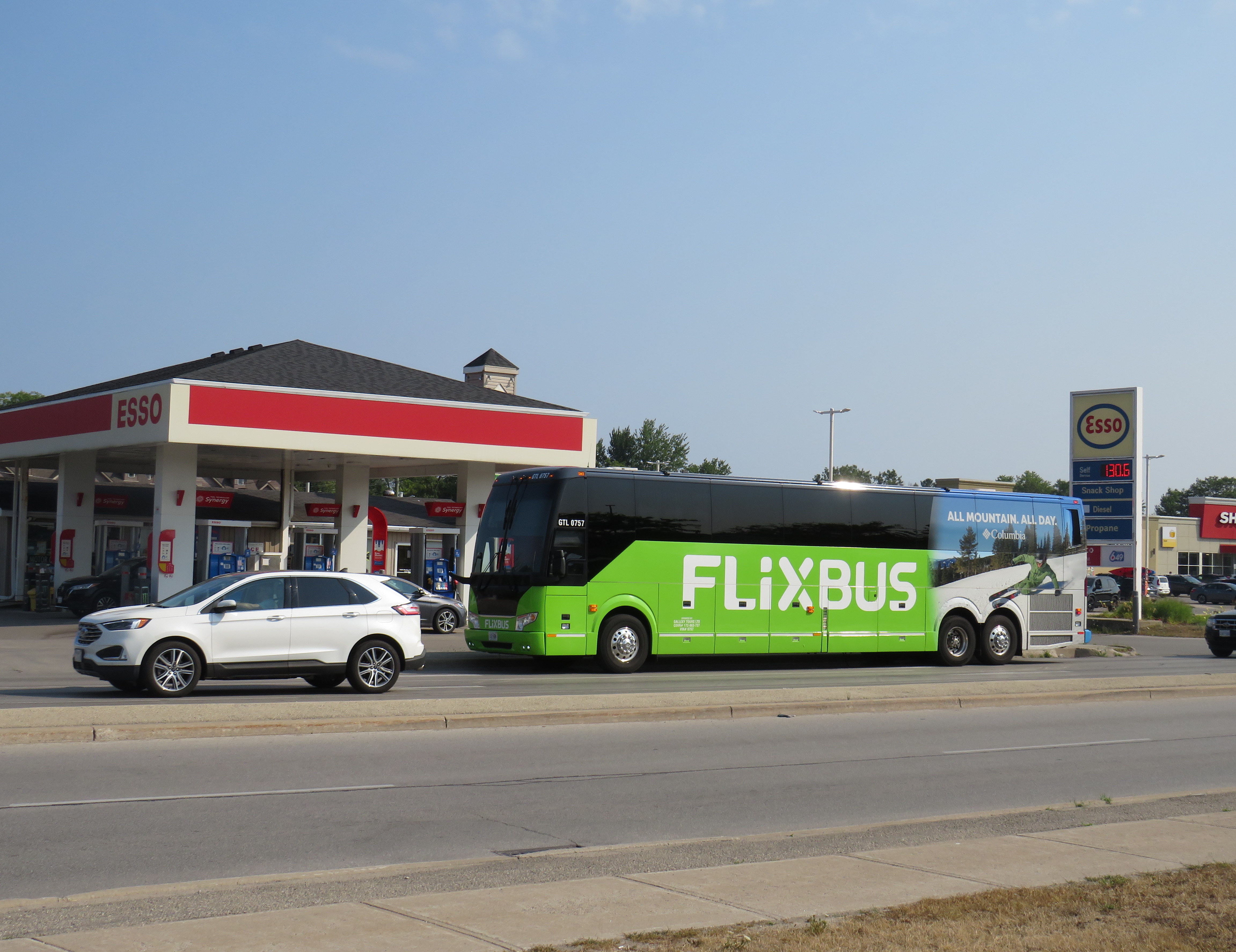
There is one daily Flixbus coach trip from Downtown Toronto and Pearson Airport to Wasaga Beach, continuing onwards to Collingwood, Owen Sound, and Port Elgin. Northbound, the bus leaves Union Station Bus Terminal at 7:30 in the morning and arrives in Wasaga Beach at 10:00. The return bus leaves Wasaga Beach at 4:20 PM and arrives at Union Station at 6:50 PM, though traffic conditions can certainly impact those times. This bus is often nearly or completely sold out.
Flixbus loads in front of an Esso gas station on Mosley Streetat 45th Street
A cheaper and more frequent option is Simcoe County Linx, a regional bus service provided by the County of Simcoe. Linx Route 2, which connects Wasaga Beach to Allandale Waterfront GO Station, connects with GO buses and trains as well as local Barrie Transit buses. Unfortunately, the Simcoe County Linx system has limited service hours, and routes do not necessarily connect with each other. The last buses on Route 2 leave Wasaga Beach and Barrie at 6:30 PM, and there is no weekend or holiday service. (The sole exception is Linx Route 4, which runs between Collingwood and Wasaga Beach seven days a week.)
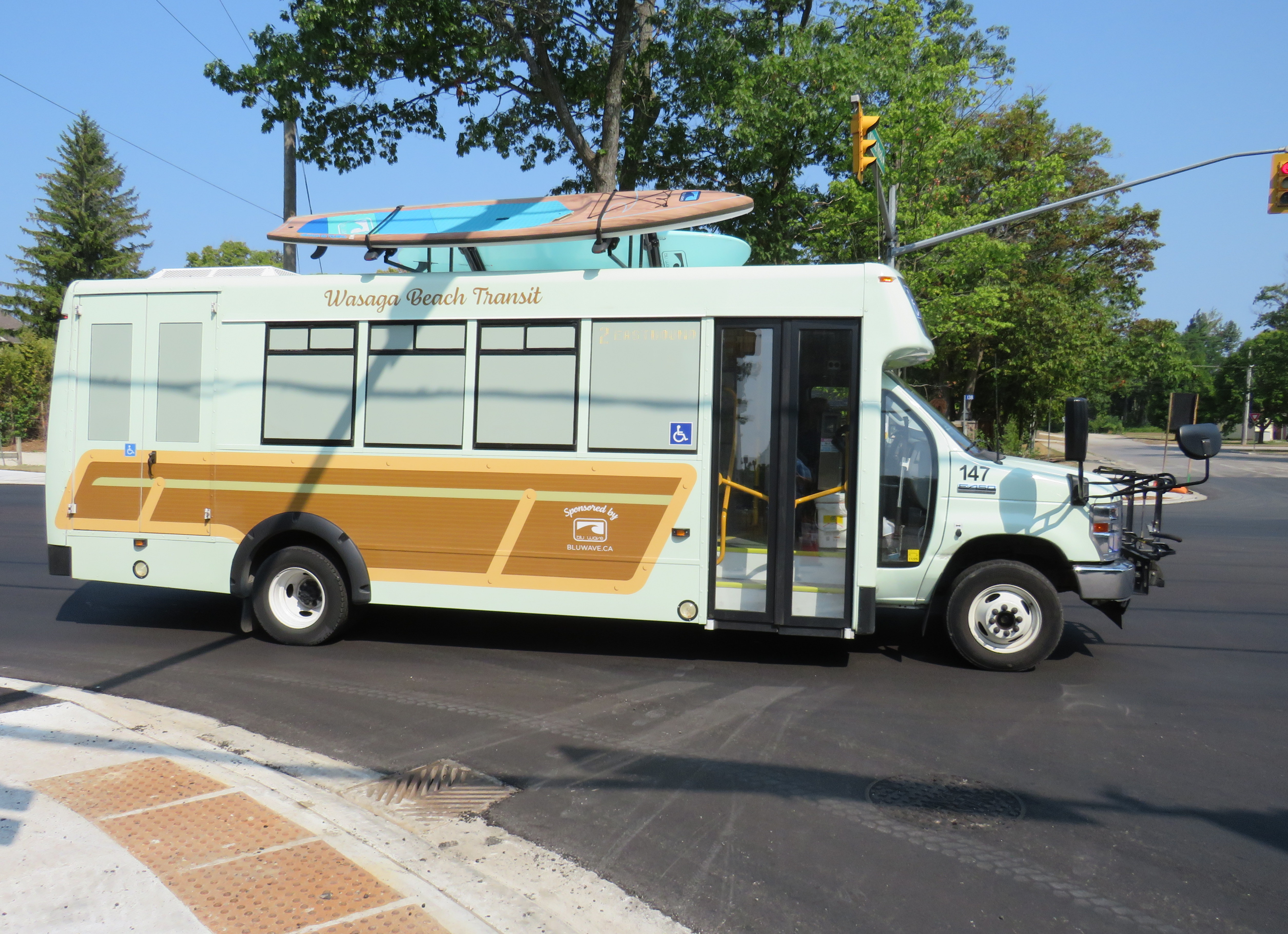
Both Flixbus and Simcoe County Linx stop on the west side of town, seven kilometres from the main tourist area at Beach Area 1. There are two Wasaga Beach Transit routes connecting these two points, but service is every 60-90 minutes. The limited bus options, combined with a lengthy transfer to get to the main beach areas, makes for an unpleasant trip. The early shutdown of Simcoe County Linx limits the time one can spend in Wasaga Beach, especially if it means a local bus transfer back to the west end of the town.
Wasaga Beach Transit minibus, decorated with vinyl wrap and stand-up paddleboards affixed to the roof
From Brampton or Mississauga, travellers must get to either Union Station or Pearson Airport to get the direct Flixbus service or get to the Barrie GO Corridor in order to make the transfer to Simcoe Linx. If there was only a direct bus up Airport Road from Peel Region, Wasaga Beach would be more accessible to another 1.5 million residents.
Furthermore, the only connections to Wasaga Beach are via Airport Road from the south and via Highway 26, a mostly two-lane highway between Barrie and Owen Sound. Wasaga Beach has never had rail access, and the former Barrie-Collingwood Railway through Stayner has been torn up. Both roads are increasingly congested due to both tourist travel and regular commuter traffic; the towns of Collingwood, Wasaga Beach, and Stayner are all growing with new residential subdivisions. Costco is constructing a new retail warehouse at Mosley Street and Highway 26 on the Wasaga Beach’s west side.
This is not just a Wasaga Beach problem. Access to most of Ontario’s other great beaches and resort towns is even more limited. Prince Edward County has a weekday-only bus service between Belleville, Bloomfield, and Picton, but it does not serve Wellington (home of the Drake Devonshire Hotel) or Sandbanks Provincial Park. Port Dover only has a weekday-only on-demand transit service accessible from Simcoe; Sauble Beach is only served by the same Flixbus route that runs through Wasaga Beach. At least Huron Shores Area Transit provides daily service to Grand Bend from both Sarnia and London.
Port Stanley used to have regular electric train service from London — where the municipality owned the railway — until 1956. Even though bus services took over from the L&PS, the only way to get there these days is to drive.
Though several Ontario cities have good urban beaches, accessible by transit — Ottawa’s Britannia Beach and Petrie Island, Hamilton Beach, and Toronto’s many beaches certainly count — there really should be better access for all to the great summer destinations like Wasaga Beach. That not only means protecting the land for public use and environmental preservation, but it also means providing accessible, sustainable, and equitable access by bus and rail. As Wasaga Beach and Collingwood seek to grow their populations and their economy, more transit is needed to connect residents to those additional jobs.
To start, Simcoe County Linx should operate Route 2 evenings and weekends. In the longer term, Simcoe County, its constituent towns, and the cities of Barrie and Orillia should merge their transit systems, focusing on fare integration and facilitating easier transfers between its routes and with GO Transit. There is also room for more intercity bus services between the Greater Toronto Area — particularly Mississauga and Brampton — with Wasaga Beach and Collingwood, offering more capacity and faster, more direct options. On my way home on Thursday, August 14, it took me over four hours to get back to Toronto Union Station via Simcoe County Linx and GO Transit buses; driving takes less than half that time, even with traffic.
Wasaga Beach is a treasure of provincial significance. It deserves to remain owned by the public and fully open to all, with better access to those who can’t or don’t want to drive.
Earlier this year, I had the opportunity to travel to the US Midwest. My spouse had a business meeting to attend in Chicago, so we made the most of our trip. I spent time in a few interesting cities, including Milwaukee, Madison, and Minneapolis-St. Paul.
Having been to Chicago many times now, I sought out new and interesting places to visit off the tourists’ beaten paths. One of these places was The 606/Bloomingdale Trail, located a few miles northwest of Chicago’s downtown Loop.
Though Chicago is famous for its elevated railway transit system (known as the “L”) it is also crisscrossed by hundreds of miles of mainline and spur railways, most of which is grade-separated from the local street network. These rail corridors were built by over a dozen railroad companies, whose vast networks converged on Chicago, bringing in, among many other things, grain, cattle, metals, and sending out cereals, meat products, industrial goods, and merchandise purchased from Sears, Roebuck and Montgomery Ward. Chicago’s dominance as a rail centre allowed it to grow into America’s second-largest city (it is now the third-largest).
There are still many railways and yards throughout the city, along with an expansive commuter rail network, but many of the industrial spurs and branch lines became redundant with the decline of heavy industry and the shift to trucking. The Bloomingdale line, once a busy freight corridor owned by the Chicago, Milwaukee, St. Paul and Pacific Railroad (known as the Milwaukee Road, later part of Canadian Pacific’s network) was just one of these routes.
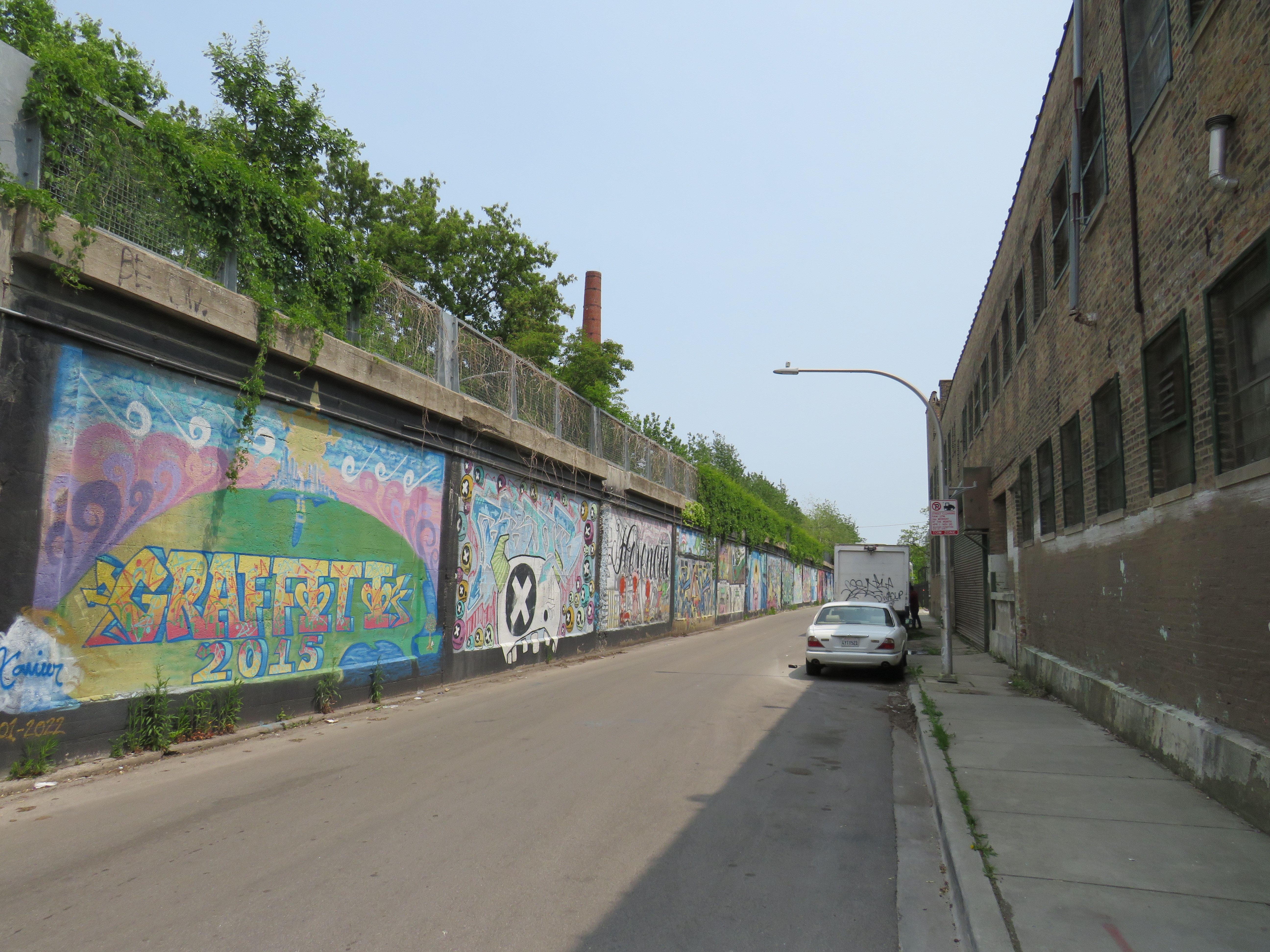
Some local industries still stand on Bloomingdale Avenue next to the abandoned rail corridor
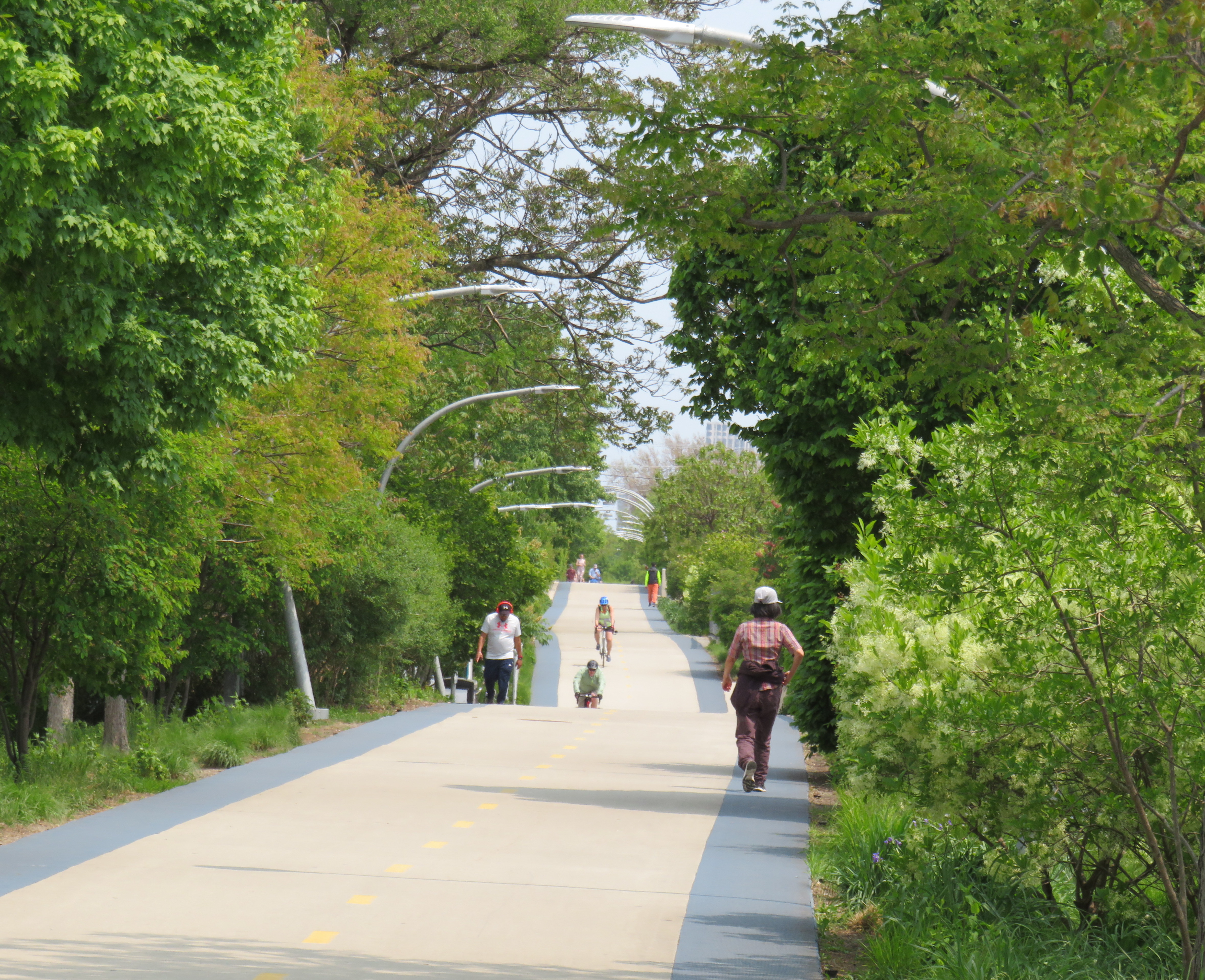
The trail, built as a partnership between the local Friends of Bloomingdale Trail group, the federal non-profit Trust for Public Land, and the City of Chicago, opened in June 2013. Ten years later, the corridor is kept in excellent shape, and still looks fresh. The 4.3 kilometre (2.7 mile) trail is the longest elevated greenway in North America, longer even than New York’s High Line.
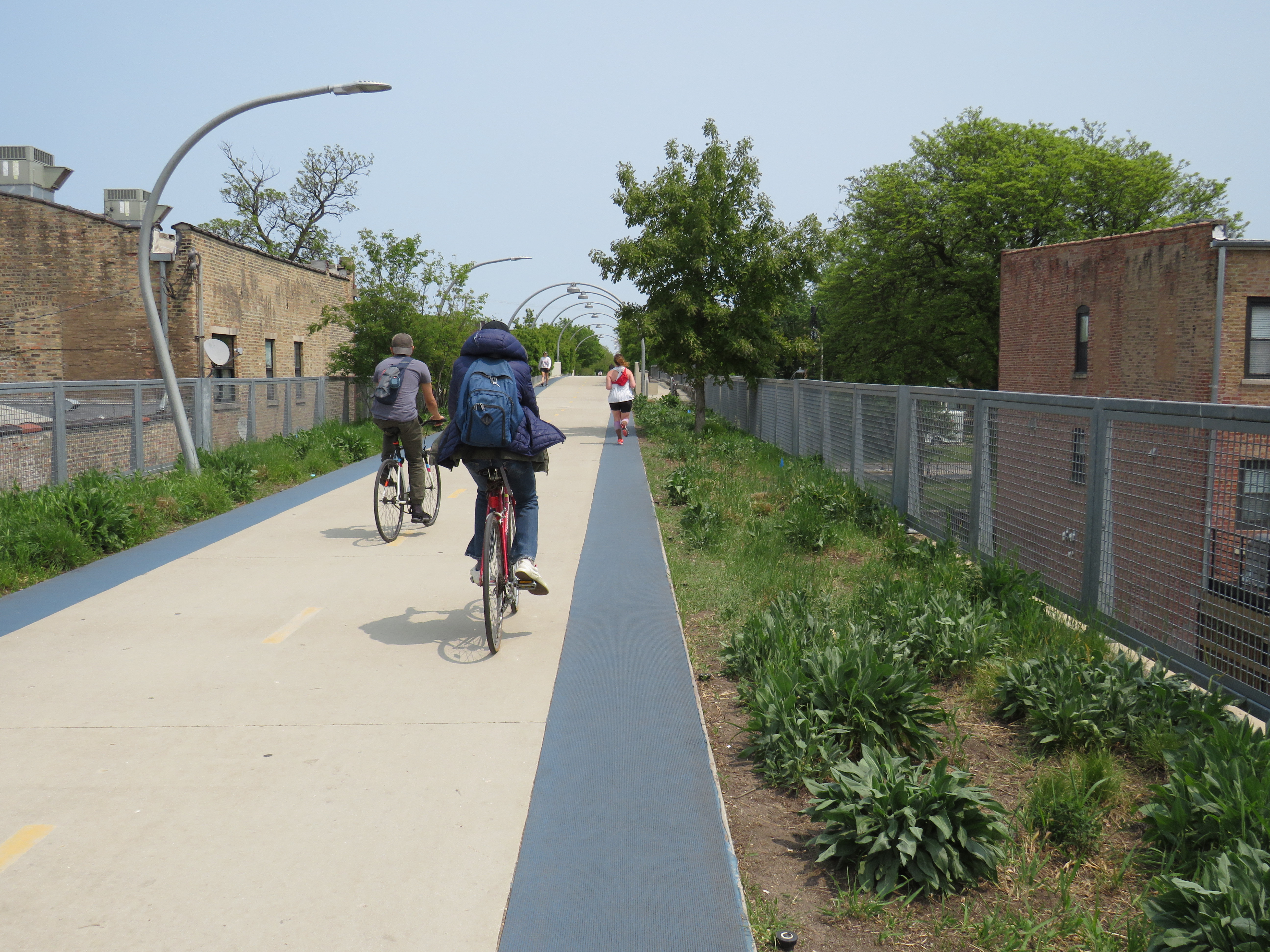
On the day I visited, I rode the entire length of the trail in one direction on a Divvy bikeshare bike and walked most of the distance on the way back.
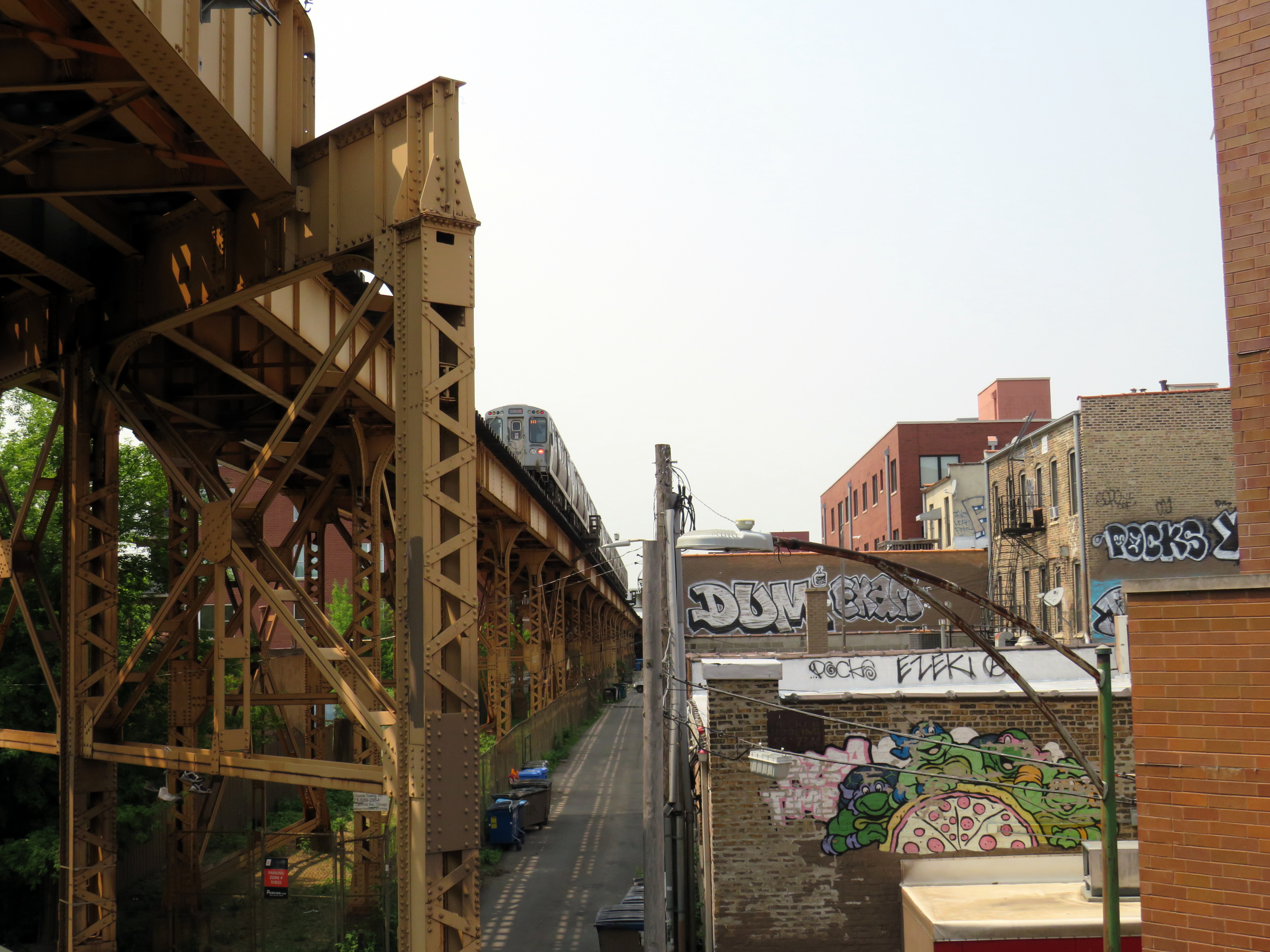
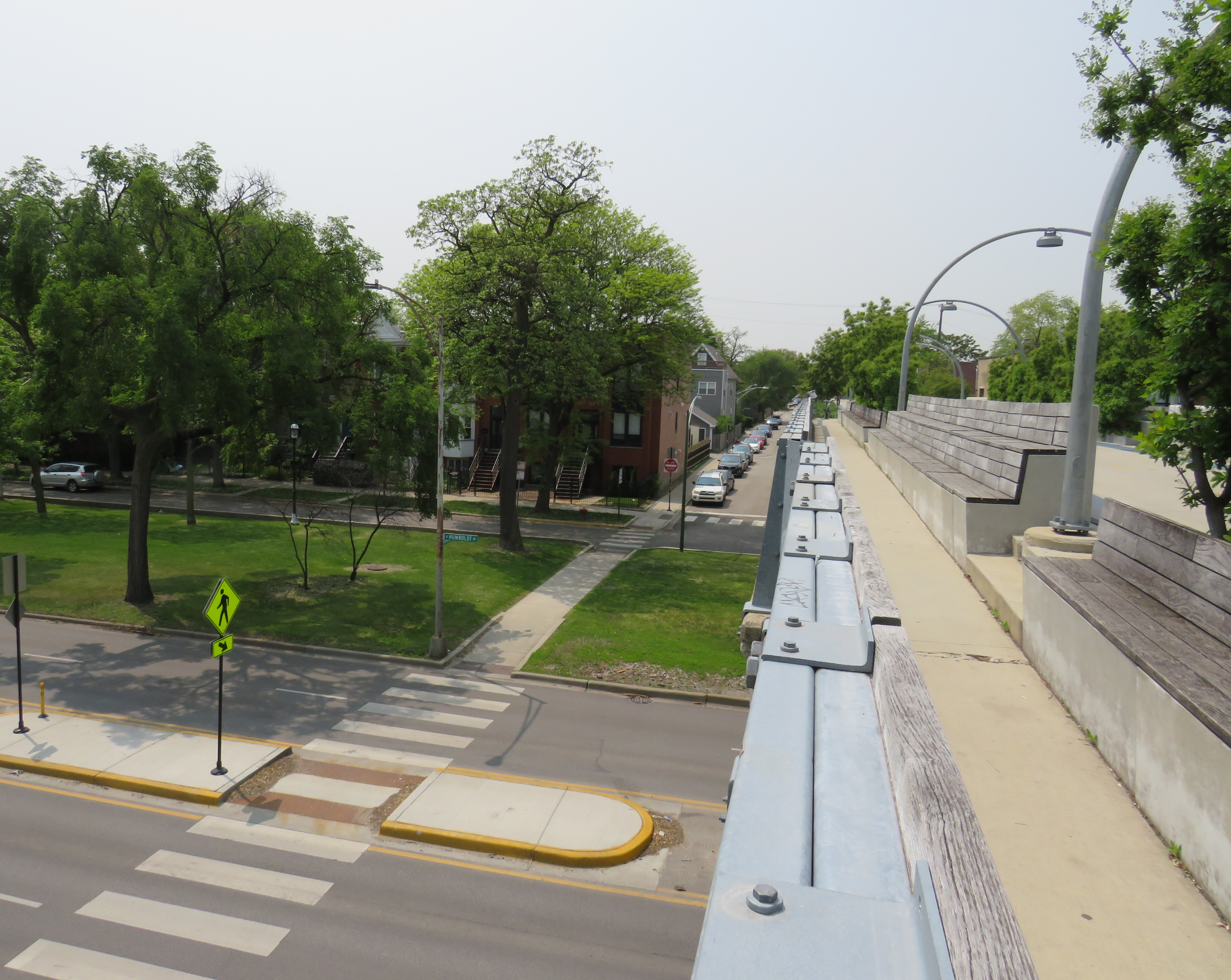
The Bloomingdale Trail crosses Central Park Avenue, near the western terminus of the public corridor
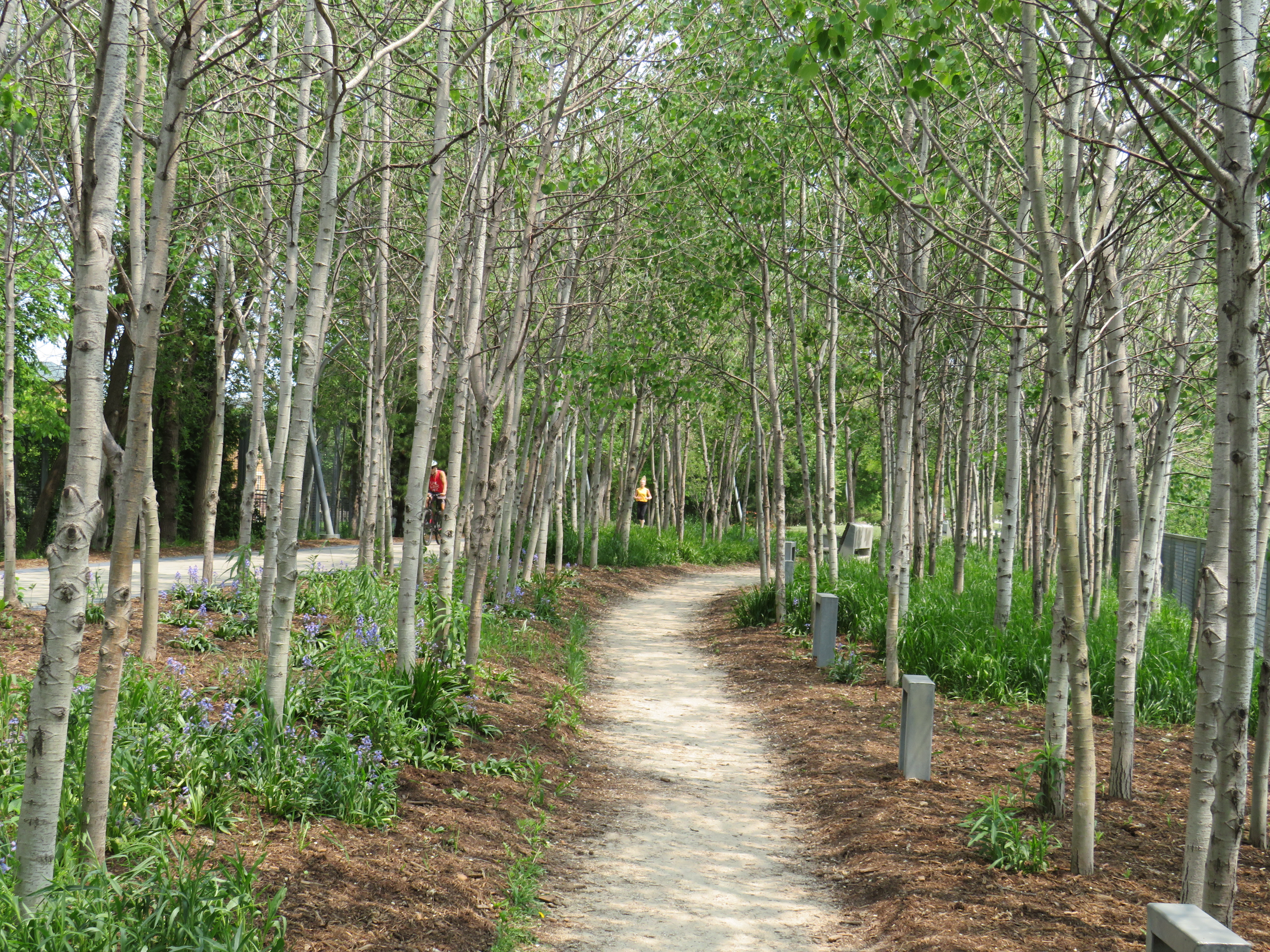
Unlike the High Line, the Bloomingdale Trail is open to cyclists, and is much less programmed, catering more to the surrounding neighbourhoods than tourists. The pathway is quite wide, making it quite suited to multiple uses. On each side of the pathway is a rubberized track, providing an incentive to walkers and runners to keep to the right. The trees are well maintained, providing plenty of shade. Benches and working water fountains are found throughout.
Rubberized edges on both sides of the pathwayOne of many water fountains along the routeA stand of poplars and a walking path at a wider part of the elevated right-of-way
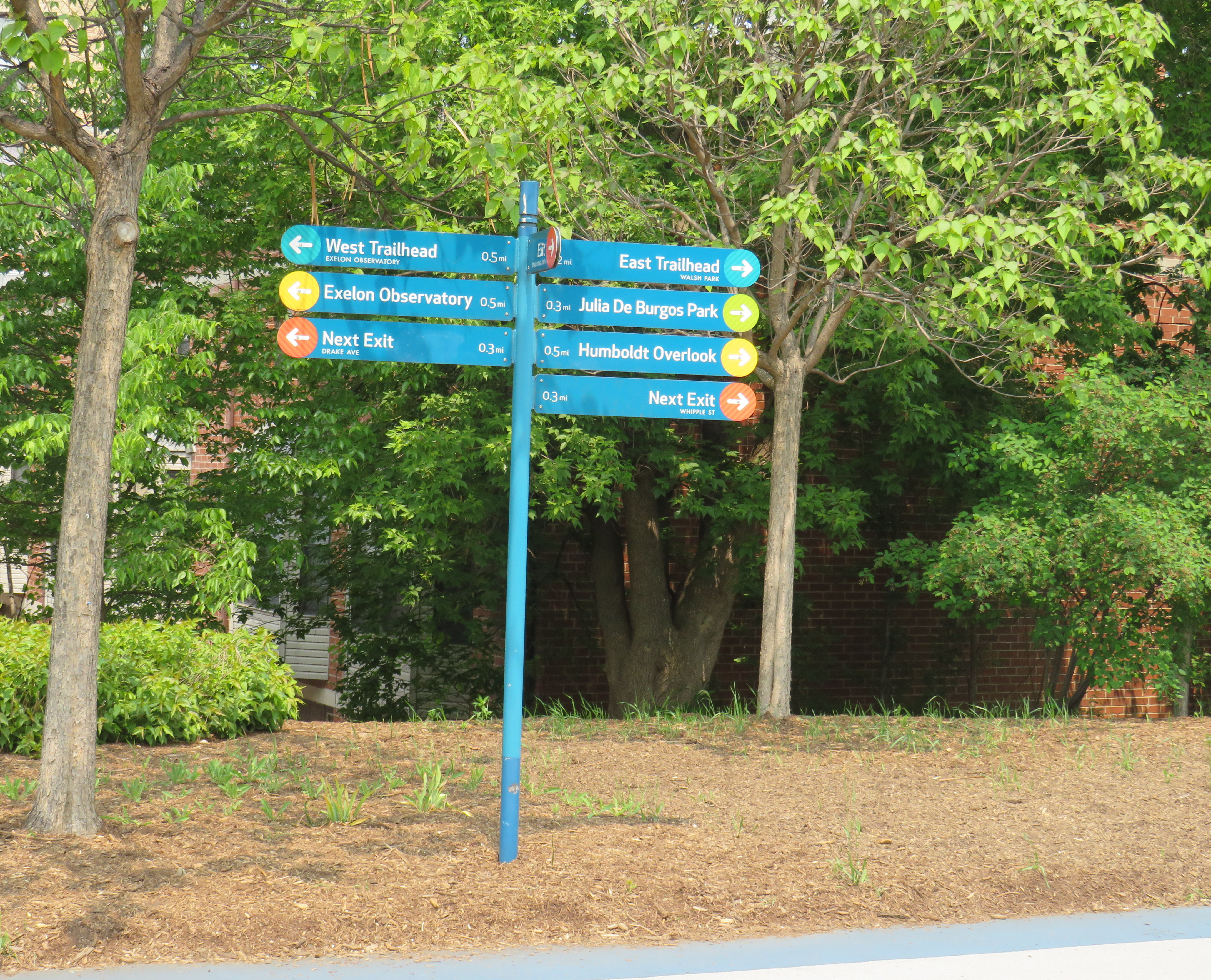
As the path follows an elevated rail corridor, not every intersecting street has an entrance to The 606/Bloomingdale Trail. However, fully accessible ramps are offered every 3-4 blocks, with stairwells installed at other locations. Wayfinding signage is good too, indicating the distances to local highlights and the nearest exits.
Wayfinding sign, indicating trail highlights, connecting parks, and the next exits
One thing I really appreciated about the Bloomingdale Trail are the unique vantage points. Milwaukee Avenue offers a lovely view towards Wicker Park and the Loop, while other parts of the trail pass by neighbourhood parks, backyards, and old warehouses.
Looking southeast down Milwaukee Avenue towards Wicker ParkView looking northwest to the Blue Line L and the alley behind Milwaukee Avenue
At several intersecting streets, benches have been strategically placed to provide gathering places called “overlooks.” Where it crosses Humboldt Boulevard, part of the parkway ring surrounding central Chicago, over hundred people could sit and watch the traffic below. at once
Lookout to Humboldt Boulevard
Though the circumstances that allowed for the great elevated parks like Chicago’s 606 or New York’s High Line are unique to their locations, there are lessons that can be learned for other projects, as in Toronto.
The presence of shade helps to make Chicago’s Bloomingdale Trail a success, as does the very wide pathway that accommodates all active transport users. (On a pleasant Thursday afternoon, the trail was about as busy as the Lower Don Trail here in Toronto, but the wide spaces reduced conflict between walkers, runners, and cyclists.) There need not be a lot of special features to animate the space, though thoughtful places to sit, hydrate, and connect to intersecting public spaces and streets are important.
There are opportunities for Toronto to expand and improve upon its off-street greenways like the West Toronto Rail Path, the ravine trails, the Greenway, and possibilities for the Green Line and East Toronto; this is just one example of the concept done well.
An abandoned railway signal towers over Philadelphia’s Rail Park
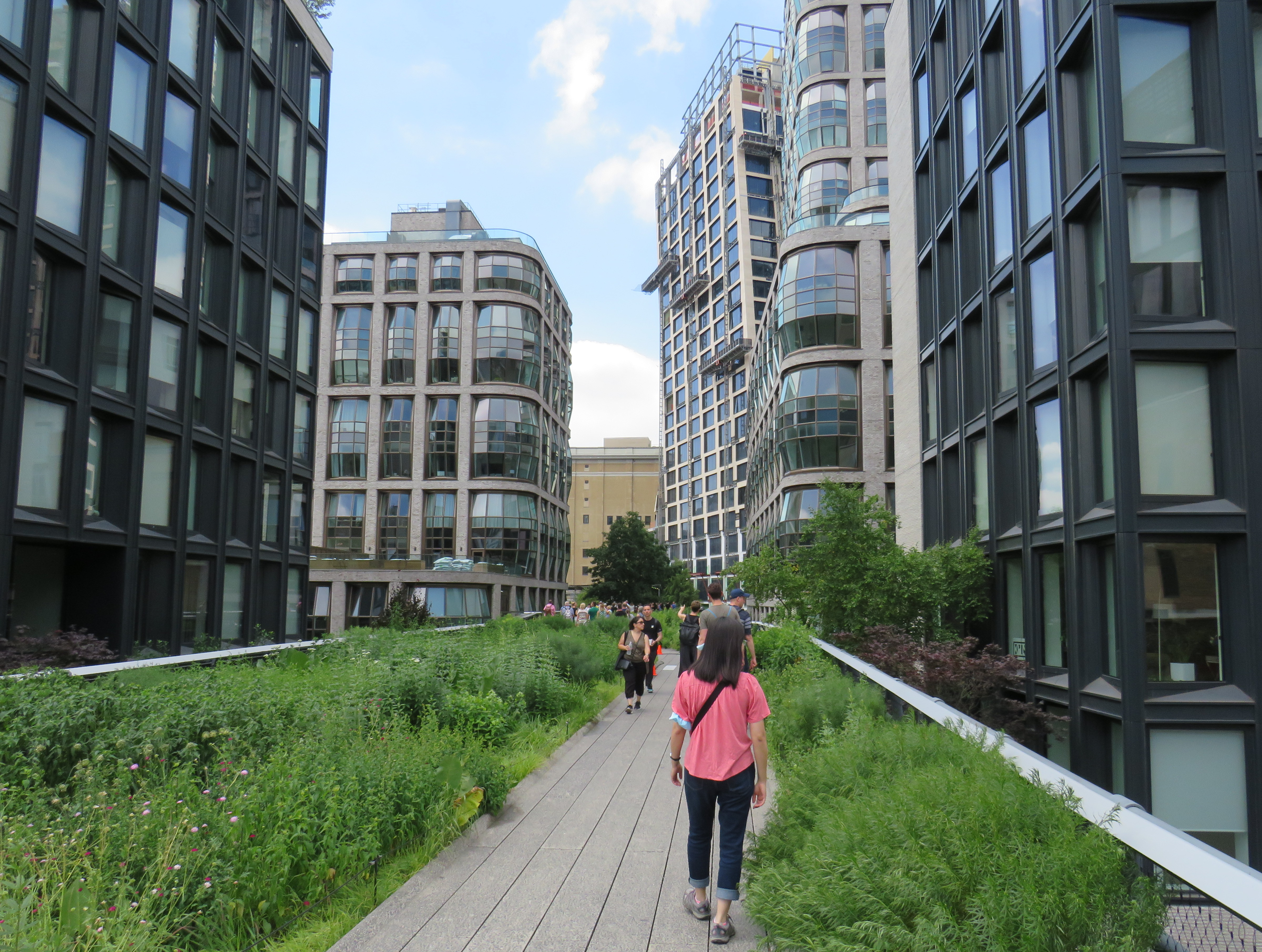
On a road trip early this summer, my spouse and I paid a visit to New York and Philadelphia. In New York, we walked the famous High Line, which revitalized an abandoned elevated freight railway corridor, transforming it into a popular grade-separated walking path on Manhattan’s Lower East Side.
New York’s High Line
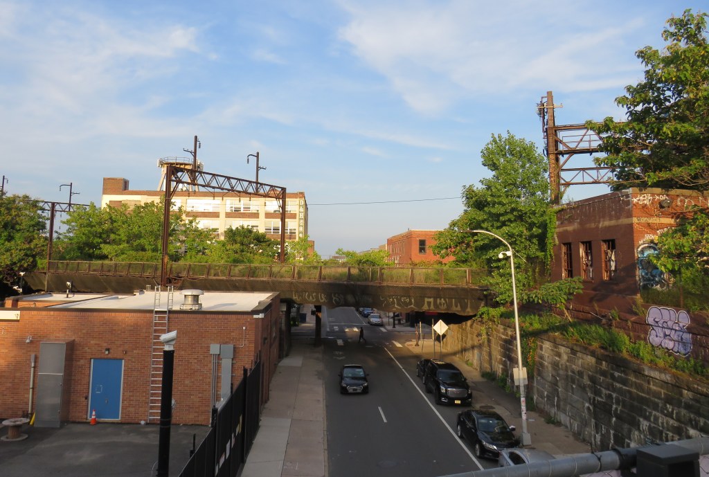
While in Philadelphia, I made a point of visiting another abandoned rail viaduct — Rail Park. It’s as ambitious as New York’s famed public space, but — for now — it is much less known.
The viaducts, cuts, and tunnels that will make up Philadelphia Rail Park trace their origin to the golden age of railroading. The Philadelphia and Reading Railroad, which connected Philadelphia with its northern and western suburbs, industrial towns to the northwest, and the lucrative anthracite coal fields of northeast Pennsylvania. For many years, the Reading Railroad, as it was known, was one of the United States’ most profitable companies. In 1893, the railway opened its Philadelphia Terminal, which became famous for the public market that was established below the station platforms. To this day, the Reading Terminal Market remains a vital city landmark. In the 1930s, most of the commuter services were electrified.
The 1893 Reading Terminal headhouse, now the entrance to the Pennsylvania Convention Center
By the 1970s, both the Reading and PRR were bankrupt. PRR merged with its New York-Chicago rival New York Central in 1968, before it too went into insolvency. Conrail took over many failing railways in the US Northeast and Midwest, consolidating operations, abandoning or transferring redundant track, and transferring most remaining commuter train operations (which were not assumed by Amtrak) to regional and state transit authorities.
In the mid-1980s, the Southeast Pennsylvania Transit Authority (SEPTA), which assumed control of the regional rail services formerly operated by the PRR and the Reading undertook an ambitious project to unite the separate regional rail systems. A new four-track tunnel was constructed east from PRR’s Suburban Station, and a new station — Market East — built to replace the old Reading Terminal. For the first time, trains could run through central Philadelphia, providing improved regional rail services.
Though the historic Reading Terminal headhouse and the famous market were preserved, the station platforms were removed to make way for a new convention centre. For years, the abandoned viaducts and tunnels leading into Reading Terminal sat unused. At least they did, until June 2018.
Entrance to the first phase of Rail Park, at Noble and 13th Streets
In 2018, a short, initial phase of Rail Park opened to the public. Spanning just two blocks, from Noble and 13th Streets to Callowhill and 11th Streets, it is still a remarkable public space. Like New York’s High Line, the short section of viaduct provides new viewpoints over gritty city streets, with temporary and permanent public art installations along the route.
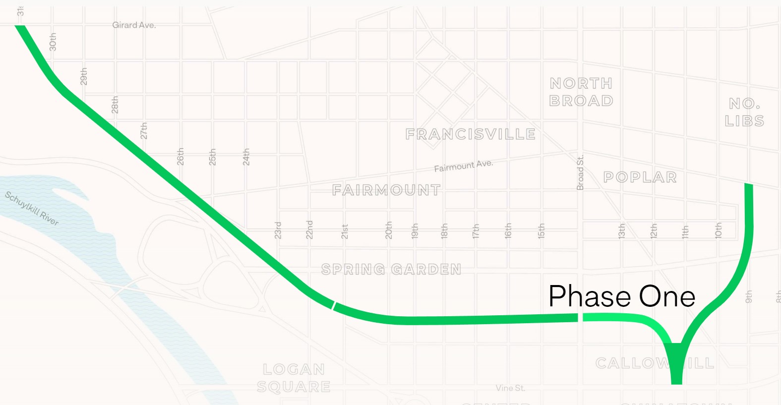
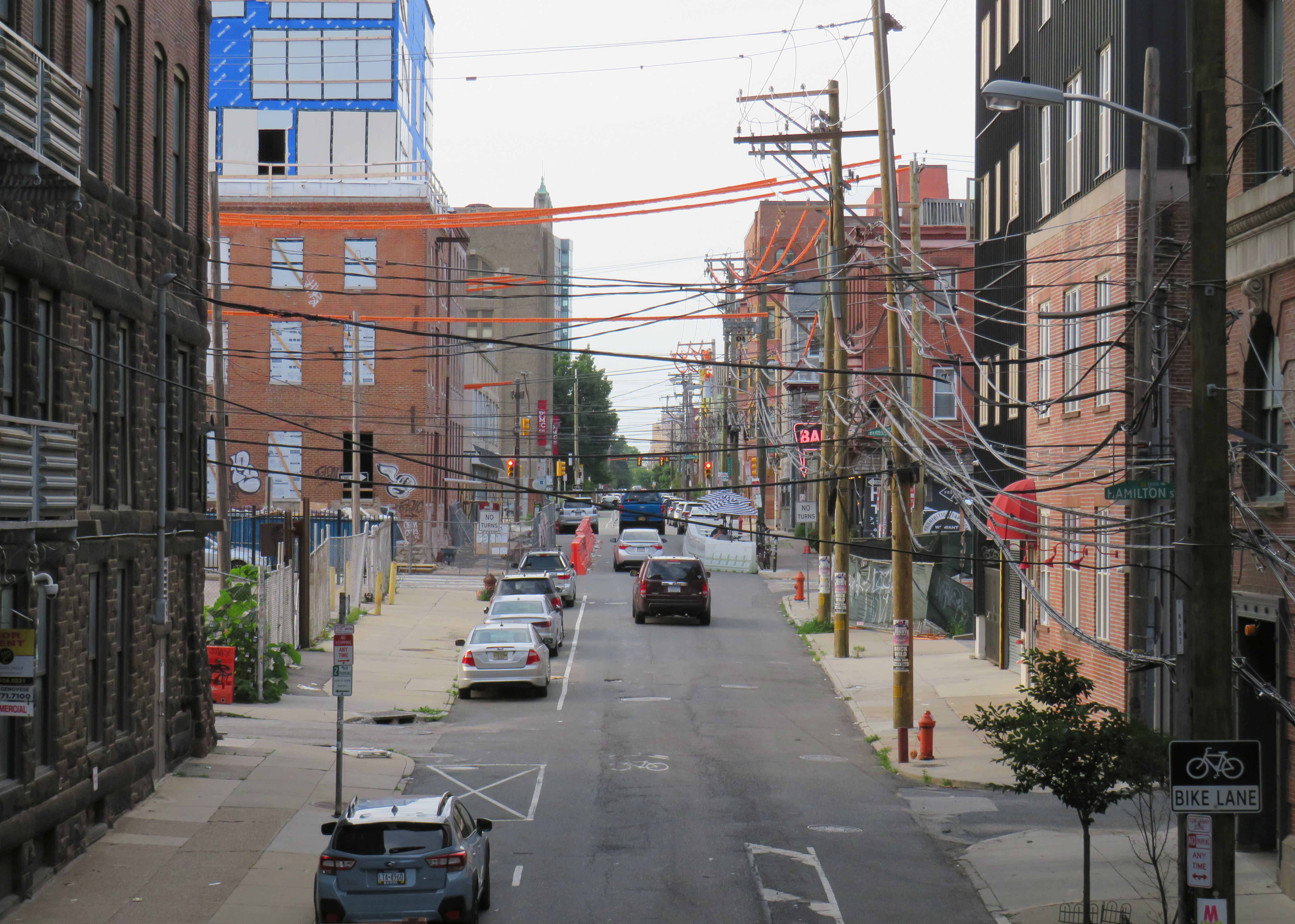
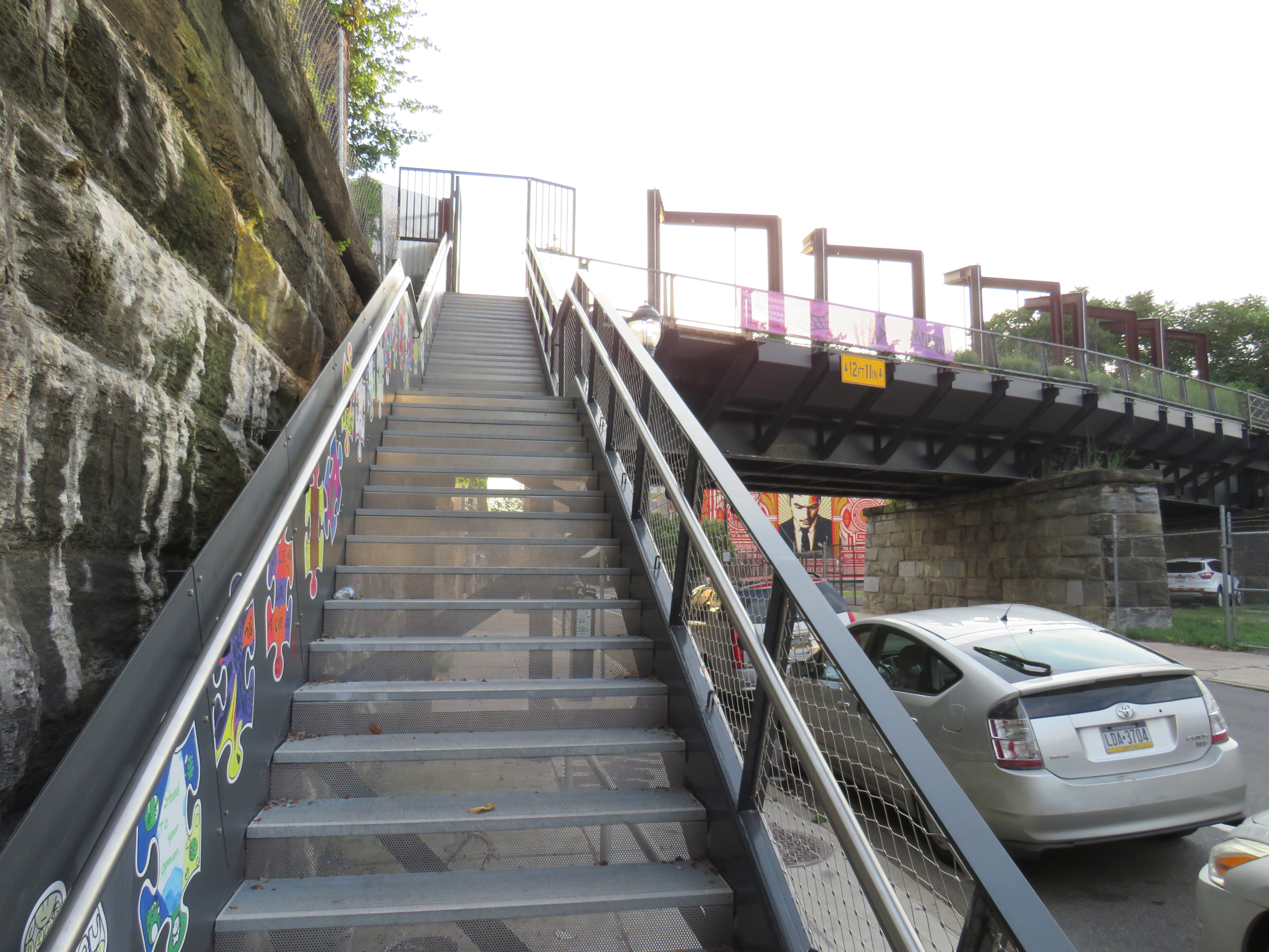
A map of the proposed extensions of Rail Park, with the opened first phase marked. Interactive map here. Looking north up 13th Street, towards the gentrifying Spring Garden neighbourhood“Workshop of the World” – an interpretive plaque provides information on the industries that lined the Reading Company’s route through PhiladelphiaAn art map of local industries that existed immediately north of Reading Terminal, made from punched Corten steelLooking east to the intersection of Callowhill and 11th Streets. For now, the only fully accessible entrance to Rail Park is at Noble and 13th Streets. The viaduct from the north is visible at left; this will be part of a future phase of Rail Park.A stairway leading up from Callowhill Street. The metal frames at the right hold swings for the public to enjoy.
Future park extensions will continue westward from 13th Street to a below-grade cut starting at Broad Street. It will continue west to the Benjamin Franklin Parkway and the Philadelphia Museum of Art (where the Rocky statue can be found outside), where it will enter a tunnel before emerging at Girard Avenue near Fairmount Park, the greatest of Philadelphia’s urban green spaces. Another section will connect the existing Phase I to the abandoned north-south viaduct between Vine Street and Fairmount Avenue, where the old route to Reading Terminal meets the 1980s rail diversion to Market East Station. Eventually, it will reach 3 miles (5 kilometres) in length.
The formerly abandoned viaduct offers a view of more recently abandoned transit infrastructure: the remnant tracks of the 23-Germantown trolley route, once the longest streetcar line in North America. In the early 1990s, SEPTA was forced to abandon three of its legacy street railway lines due to budget pressures and deteriorating PCC equipment. (Newer Kawasaki-built streetcars were only deployed on the surface-subway routes in West Philadelphia and on the former Red Arrow suburban lines from 69th Street Station.) The 15-Girard Line was later rebuilt with refurbished streetcars, but the 23 and 56-Erie lines were left to rot in a state of “temporary suspension.”
SEPTA has a wealth of transit infrastructure, which I wrote about after my first visit to Philadelphia in 2009, but it hasn’t put enough of it to good use. It has a massive, fully electric regional rail network, yet trains operate only every hour on most routes outside of peak periods. There’s a four-track subway tunnel under Broad Street that’s grossly underused, and unlike Toronto, there are even a few active trolley bus routes. And sadly, it’s allowed much of its infrastructure, like its trolley network, to remain in disuse.
A view down from Rail Park to long-disused trolley tracks on 12th Street
Update December 14, 2020: With outdoor skating rinks fully opened for the season, I have added the washrooms located at each of these facilities open this winter. Though many rinks will have to be pre-booked to use (to limit crowds during the pandemic) the city has provided access to adjacent indoor washrooms. I also noted the addition of a portable toilet at Guild Park, something I commented on previously.
Please note, though, that many portable toilets have not been kept in good service. I suggest bringing hand sanitizer on your walks in case you need to use one of these temporary facilities.
Update November 28, 2020: I have added the list of 51 temporary portable toilets that the city has or will be adding to its parks this winter as part of an effort to encourage Torontonians to get outside for winter walks. Many of these locations are along the major ravine paths, including the Don and Humber Rivers. Most location descriptions were easy to locate, though others were quite vague. I did the best I could with the information given. I also added the toilet locations at Tommy Thompson Park, which is operated by the Toronto and Region Conservation Authority.
There remain some critical gaps, including the absence of Guild Park in Scarborough and along the waterfront between Humber Bay Shores and Marie Curtis Park, but on the whole, this is a positive development. The city also announced new winter maintenance of additional park paths, though ideally, this service would be extended along the entire ravine network.
As of Monday, November 23, Toronto and Peel Region will be in another lockdown. Non-essential businesses and services will close or be open only for take-out and curbside pickup. Gyms, patios, and salons will all be closed. Though we may not be able to socialize with friends and extended family, we can still go for walks, runs, and bike rides to maintain our physical and mental heath.
But with indoor dining prohibited since October in Toronto, and most malls closing down, finding a washroom has become much more difficult. Many outdoor park washrooms are not winterized, so they must close as well. For many of us, having access to open and accessible washrooms is a necessary when leaving the home for long periods of time.
Though there is a list of washrooms open (or soon to open) on the city’s website, they are listed in alphabetical order, without easily-accessible location information. I took the liberty of mapping each park washroom location, as well as selected other city-owned public washrooms accessible seven days a week.
Though winterized public washrooms can be found across the city, there are a few areas left unserved, including the Etobicoke waterfront between Humber Bay Shores and Long Branch, the eastern Scarborough waterfront parks, including Guild Park and the Port Union/Rouge Beach area, and northwestern Etobicoke. Ideally, every Torontonian should live within walking distance of a four-season park.
Even with the impending lockdown, there are some other washrooms that will remain available when necessary. GO Transit has kept washrooms at its stations accessible even during the Spring 2020 lockdown. On the Lakeshore Line, stations are open seven days a week, including Guildwood and Rouge Hill. Many supermarkets have public washrooms as well.
I hope that there will be improved four-season access to public washrooms this year, and every year going forward. Simple outdoor activity, including long walks, are one of the safest and easiest things we can do to keep ourselves happy and busy.
I will update the map as more washroom facilities open.
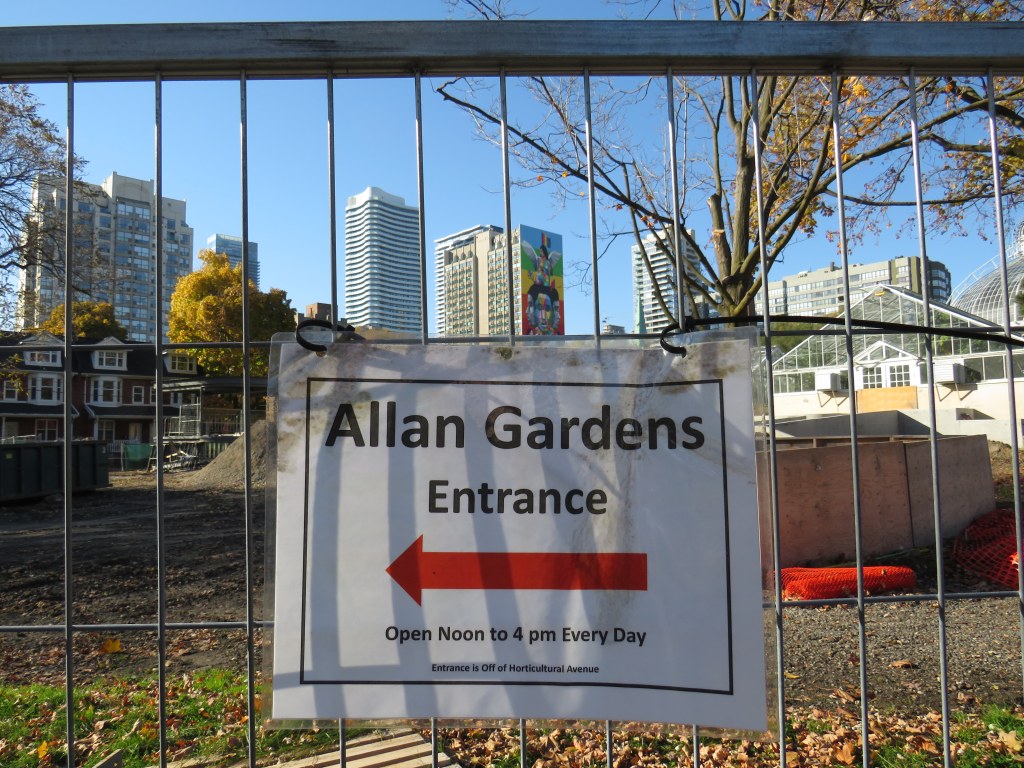
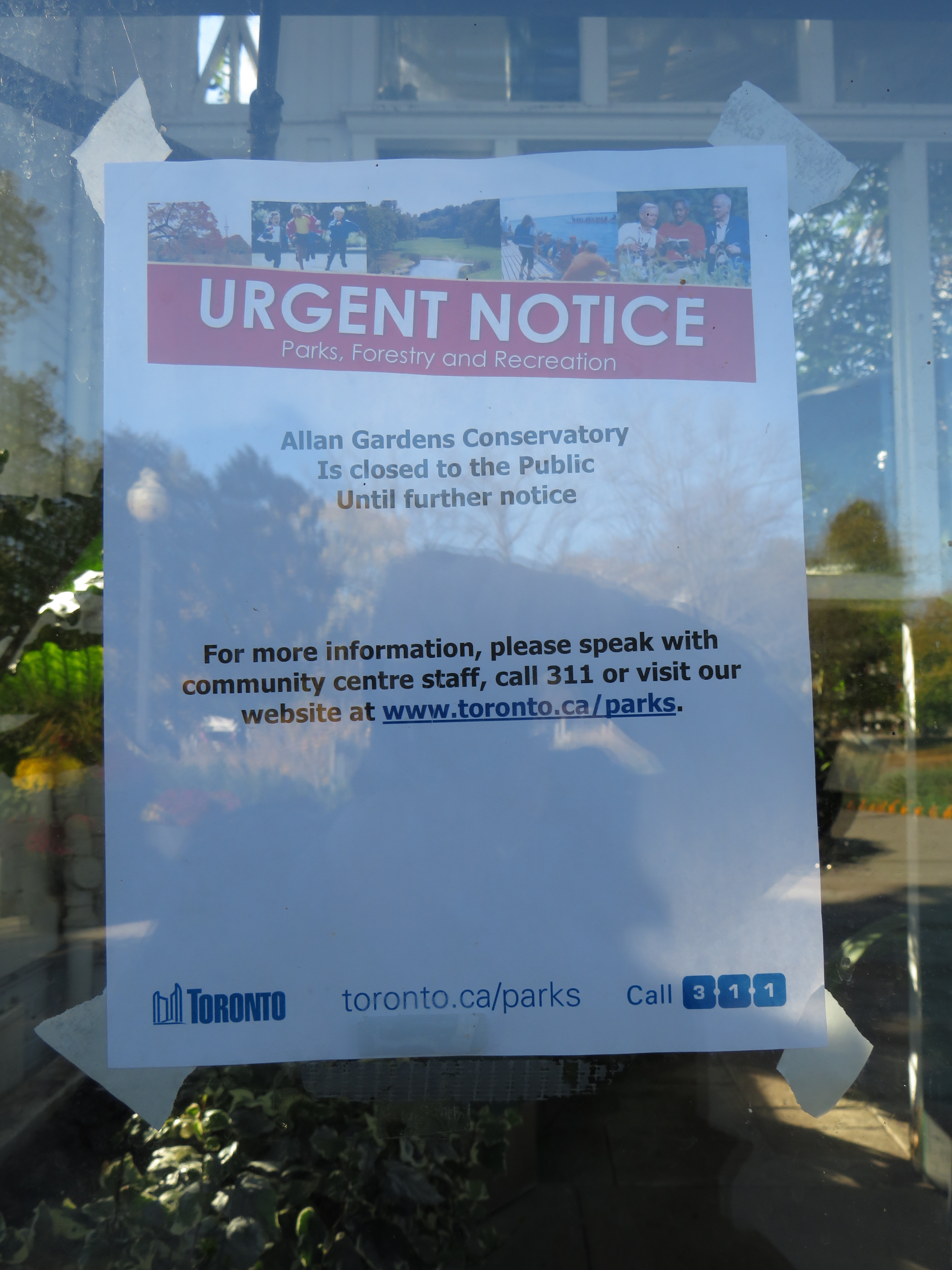
On November 4, signage scattered around Allan Gardens leads visitors to locked doors
The ongoing pandemic, to quote the prime minister, “really sucks.” Ontario has been subjected to various levels of lockdowns and restrictions for nearly eight months now as COVID-19 case counts continue to be high. Restaurants, bars, cinemas, and gyms are currently closed in Toronto, as are most other indoor venues. Many of us are — if we’re lucky — working from home, but shut off from meaningful socializing from family, friends, colleagues, and allies. Many are left unemployed with few job openings out there. Those still working in factories, warehouses, public institutions, kitchens, and stores face increased pressures without many of their supports.
That leaves only a few outlets for selfcare: the support of immediate family, outdoor exercise, and passive entertainment such as streaming shows and movies online. Though I am working on several interesting projects here at home, I can attest that Zoom calls, Facebook chats, and occasional phone-calls are no substitute for in-person social interaction. Regular walks have been essential to my mental health, which has suffered during the pandemic. With so much construction in my neighbourhood, there has been one nearby oasis: the conservatory at Allan Gardens.
Sadly, that’s no longer an option, and I found that out the hard way. Though it is a minor complaint given the much larger failure to control the virus here in Ontario and properly communicate important public health information and advice, it’s just a microcosm of the mixed messaging from all levels of government that we have been enduring since February.
“Urgent notice” – anyone who continues past the signs directing visitors to the designated entrance to the Allan Gardens Conservatory is greeted with this notice indicating that the building is closed until further notice(more…)
Parks across Canada are closed, with the exception of walking through
On Saturday April 11, during the Easter long weekend, the City of Toronto announced that a team of over 350 police officers and bylaw enforcement officers would shift from an education-based campaign of verbal and written warnings to people congregating and using closed amenities in parks to a zero-tolerance ticketing campaign. Tickets for violating orders — intended to slow the spread of COVID-19 — include a fine of up $1,000.
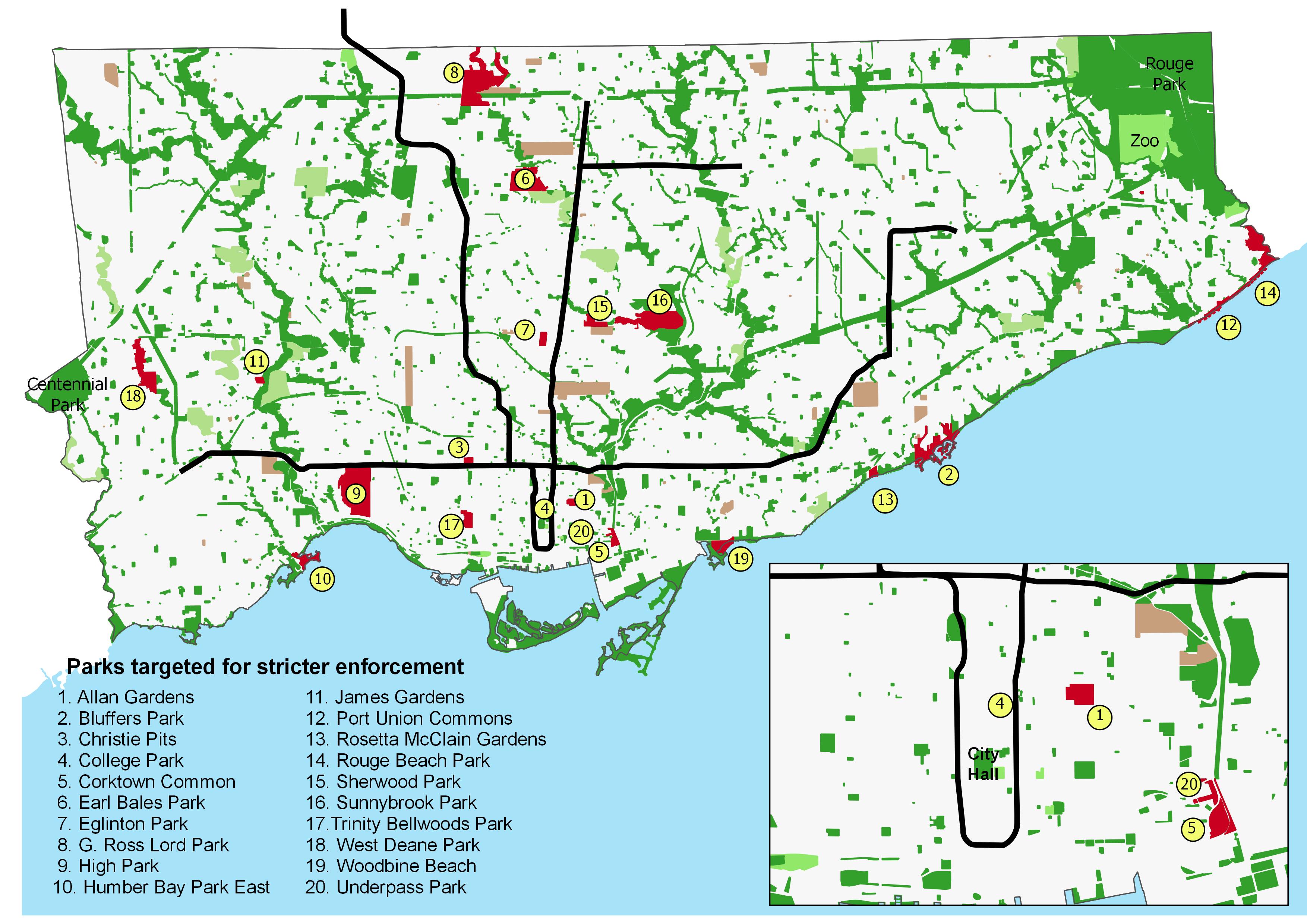
In the press release, the city listed twenty parks specifically targeted for enforcement. Though most are located in the old City of Toronto and along Lake Ontario, there are several others located in Toronto’s inner suburbs.
The list of parks include several along Toronto’s waterfront, including Humber Bay Park, Woodbine Beach, and Bluffers Park. It also includes several small downtown parks adjacent to recent high rise residential development, including Corktown Common, College Park, and Allan Gardens. Large suburban parks known for family gatherings and picnics, such as Earl Bales, G. Ross Lord, and Sunnybrook Parks are also on the list.
These parks are illustrated in the map below.
Parks targeted by the City of Toronto for stricter enforcement (click for larger image)
Though many of us are at home, working remotely or waiting for schools and workplaces to reopen, those employed in essential industries and services do not have a choice. For the rest of us not required to self-isolate, an occasional walk or bicycle ride is good for our mental and physical well-being. It may be necessary to pick up food and prescriptions.
For those of us without yards and quiet residential neighbourhoods, going outside means either navigating narrow and occasionally crowded sidewalks, or going to nearby small and busy parks, especially those without access to a car. In my experience so far, the vast majority of people are respecting the calls for physical distancing.
Closing parking lots and amenities such as playgrounds and picnic facilities makes sense. Where possible, we shouldn’t be straying far from home while physically distancing, and we should be keeping close to those we’re living with. Meanwhile, tens of thousands of people live in apartments in Mimico and Humber Bay Shores; they shouldn’t be crowded out of their own backyard by others seeking a stroll along the waterfront.
But downtown and in the Yonge-Eglinton area, quiet open spaces close to home may be hard to come by. Sidewalks are narrow, construction barriers such as scaffolding make physical distancing especially difficult, and along Eglinton Avenue, Crosstown LRT construction has made getting around on foot especially challenging, with pedestrians often restricted to narrow passages.
These help to explain the problems at College Park, Eglinton Park, and Allan Gardens. Furthermore, Allan Gardens is close to several shelters and social services such as Seaton House, and has long been a place for marginalized residents to socialize and linger.
This was the argument made by two associate professors of epidemiology at Ryerson University, who sent an open letter to Mayor John Tory and the city’s medical officer of health, Eileen de Villa, arguing for more road space for pedestrians and cyclists.
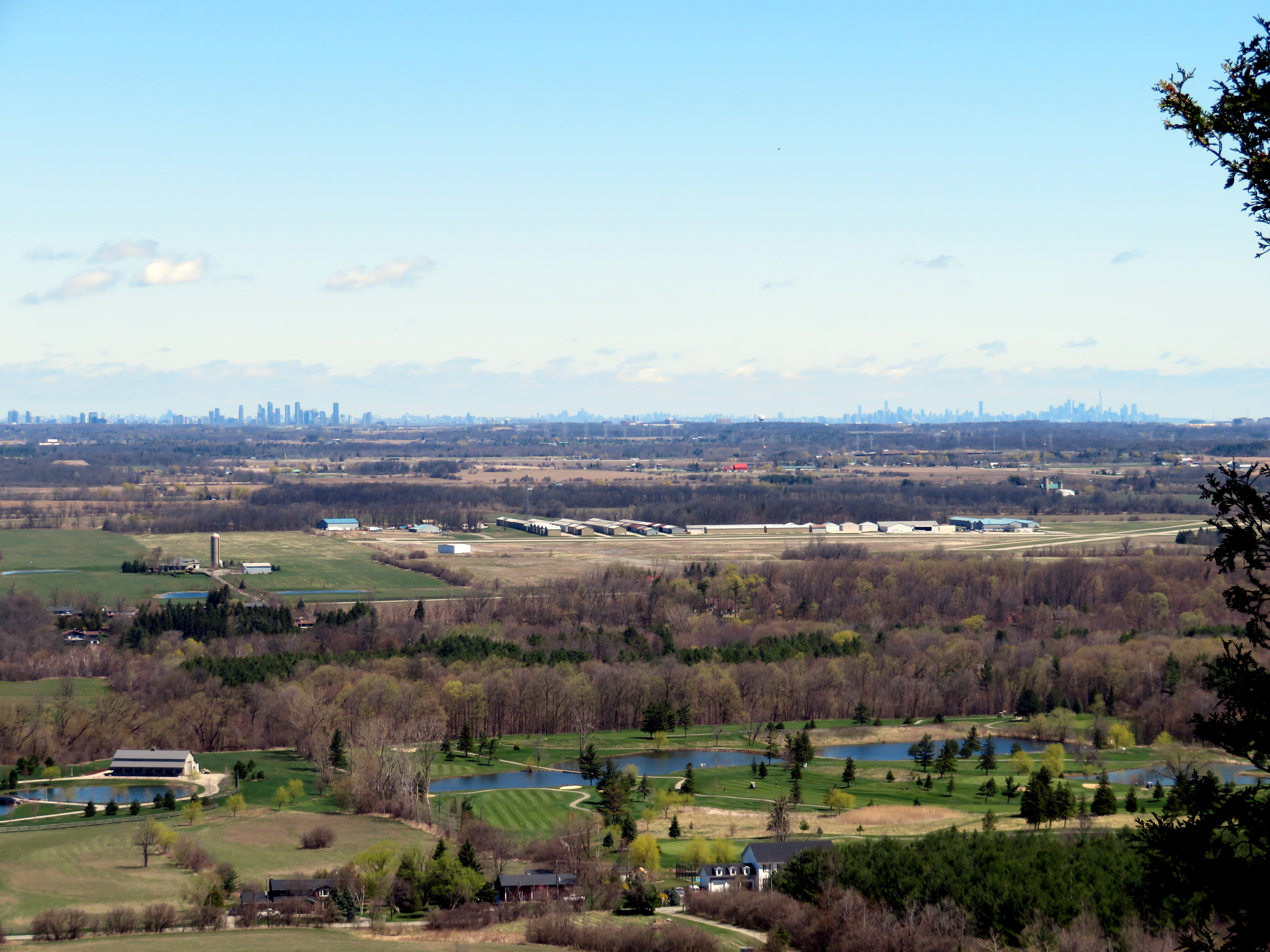
View from the Niagara Escarpment at Mount Nemo Conservation Area towards Mississauga and Toronto
One of Ontario’s greatest success stories has been the development of conservation authorities (CAs). The provincial Conservation Authorities Act was introduced in 1946 to provide for new joint provincial-municipal bodies protect farmland and natural features from deforestation, flooding, and erosion, organized not by political boundaries, but by watersheds. In 1954, south-central Ontario was hit by Hurricane Hazel, which caused extreme and deadly flooding. This highlighted the need for strong local authorities to coordinate flood protection strategies, including dams, floodways and reservoirs, but also land use planning, the protection of headwaters, and the naturalization of important landscapes, such as the Niagara Escarpment and Toronto’s ravines. Planners at CAs help to ensure that any new development is protected from flooding or erosion and will not negatively impact other properties or the watershed as a whole.
Most of Ontario’s 36 CAs also operate conservation areas, open to the public as parklands. These may contain hiking trails, wildlife sanctuaries, campgrounds, lakes and reservoirs for swimming, boating, or fishing, as well as waterfalls, caves, scenic lookouts, or other unique natural features. A few conservation authorities also operate historic sites, including old mills, or even entire pioneer villages, such as Black Creek. Many CAs also hold special events, such as festivals, school tours, and even concerts.
Many of these programs and services are incredibly important, but all are beneficial to the public. And they are under attack by the provincial government.
Earlier this year, the province cut funding for natural hazards planning by 50 percent. Late last week, the minister for Minister of Environment, Conservation and Parks, Jeff
Yurek, sent a letter to all CAs and their partner municipalities to begin to wind down any programs not directly related to their “core mandate.”
Yurek commented that “over the years, conservation authorities have expanded past their core mandate into activities such as zip-lining, maple syrup festivals and photography and wedding permits.”
One such CA, Conservation Halton, operates several conservation areas in Halton Region and the City of Hamilton.
Kelso Conservation Area includes a ski hill, a reservoir that provides for paddle boating, fishing, and a swimming beach, and a campground. There are also outdoor movie nights. At Mountsberg Conservation Area, Conservation Halton operates a Raptor Centre, where injured birds of prey are treated and shown to the public. It also has one of those maple syrup festivals in its sugar bush.
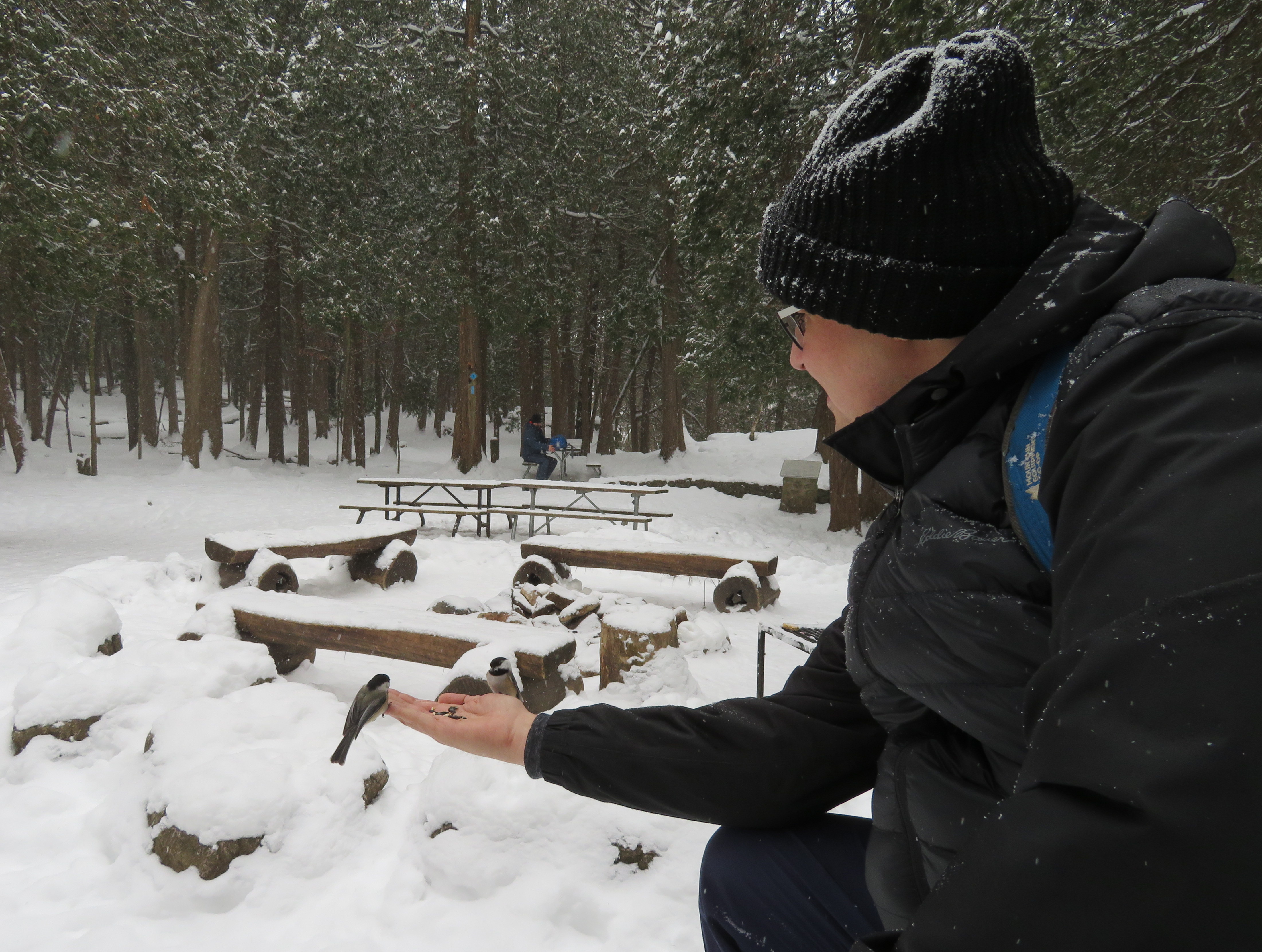
Feeding chickadees at Hilton Falls Conservation Area
Conservation Halton has a $30 million annual budget, but it only gets $145,000 from the province for core programs. The rest of its funds come from municipalities and from park user fees, rentals, and sales. The festivals, event bookings and wedding permits help fund the important conservation work. Offering festivals and other special events also help engage the public, especially children.
Of course, the Doug Ford-led Progressive Conservative government’s attack on conservation authorities isn’t about saving money. Instead it’s about restricting their mandate, reducing their ability to raise funds and engage the public.
Perhaps this all has to do with the influence of the development industry. Ontario Proud, a third-party advertiser connected with the Progressive Conservatives, ran attack ads on social media and on outdoor billboards against the last Liberal government in 2016 and 2017. It was funded by the development and construction industry, with Mattamy Homes being its largest contributor. The province also weakened planning legislation and municipal power to restrict new development through Bill 108, the so-called More Homes, More Choice Act.
If the Ford government gets its way, conservation authorities will have fewer resources to protect watersheds and natural lands and reduce the risk of the effects of climate change. Without maple syrup festivals and other “non-core” programming, there will also be less fun and reduced awareness of Ontario’s wonderful natural landscape. This isn’t about fiscal responsibility. It’s about ideology and payback.
There are plenty of developers who’d love to pave over the Greenbelt
Yesterday, Thanksgiving Monday, mayoral candidate Jennifer Keesmaat proposed closing three of Toronto’s five municipally-owned golf courses. Keesmaat, Toronto’s previous chief planner, pointed out that the municipal golf courses operate at a loss, and that $10 million is allocated for improvements to those three courses. Furthermore, she intends to consult the local communities to best re-program the sites to address local wants and needs for the opened-up greenspace.
The three courses are:
Dentonia Park Golf Course, located on Victoria Park Avenue north of Danforth Avenue, next to Victoria Park subway station, in the Massey Creek ravine.
Don Valley Golf Course, located in the West Don Valley near Yonge Street and Wilson Avenue, near York Mills Station. It extends under Highway 401.
Tam O’Shanter Golf Course, near Sheppard Avenue and Kennedy Road in Scarborough, and the Humber Valley Golf Course in north Etobicoke, are not mentioned in Keesmaat’s proposal.
Today, I'm announcing my proposal to transform the massive parcels of public land currently occupied by three under-utilized City-owned golf courses on major transit routes into spaces that are accessible to the public year-round for no fee. #Keesmaat4Mayor#topoli
I’m very happy that Keesmaat has put forward this bold idea. Despite the municipal ownership of these lands, they are fenced off from residents. For example, Dentonia Park is located in a lower income neighbourhood made of many high-rise rental buildings. As Toronto continues to grow in population, greenspace reserved for golfers could be put to better uses such as sports fields (soccer and cricket, especially), playgrounds, natural wetlands and woodlands, and public paths.
Golf is an expensive leisure activity with a large environmental footprint: the tending of golf courses require lots of water and pesticides. (Golf courses are exempted from a provincial ban on certain types of pesticides.) They may not adequately address the local community’s needs either, especially in lower income areas. Interest in playing golf is waning in North America as well. It makes sense to open up these publicly owned lands.
Golf courses get in the way of potential linear parks. As I mentioned before, the Don Valley Golf Course blocks access to Earl Bales Park from the south. Opening up the grounds to the general public would provide a continuous path from York Mills Station to Bathurst and Sheppard and beyond. This would provide a safe and pleasant walking and cycling route across Highway 401, compared to the unpleasant and dangerous crossings at the interchanges with Yonge Street and Avenue Road.
Dentonia Park Golf Course sits in between the path through Warden Woods and the Taylor Creek Ravine. If opened to the public, there could be a car-free path for pedestrians and cyclists all the way from Warden and St. Clair Avenues all the way downtown via the Don Valley trail system.
Keesmaat’s plan to close money-losing, poorly-used golf courses is a great idea, much like her promise not to go ahead with the costly replacement of the eastern section of the Gardiner Expressway, instead going with the locally preferred boulevard option. Both of these ideas may not be popular with some, but they are both fiscally and environmentally sound.


 Feeding chickadees at Hilton Falls Conservation Area
 There are plenty of developers who’d love to pave over the Greenbelt
 Dentonia Park Golf Course