Last week Monday, I was at Spacing’s election night party at a pub in the Annex, watching the results of the election roll in after 8PM. Public polls consistently saw former Toronto city councillor and NDP MP Olivia Chow leading an especially crowded race of 102 candidates for mayor. It was the most exciting election […]
Category: Election
As has become my tradition after Toronto’s municipal elections, I mapped out the poll-by-poll results of the mayoral race and some of the more interesting council races. After creating maps for the 2014 election and sharing those on social media, it was suggested that I have a website to host these maps. That is how […]
This coming Monday, October 24, Ontarians will be electing new city councils. In Brampton, Ottawa, and Hamilton, the mayoral races should prove to be interesting. For Ottawa in particular, with Jim Watson stepping down, voters have a clear choice (and I’ll be cheering for Catherine McKenney). Though Gil Penalosa offers a new vision of a […]

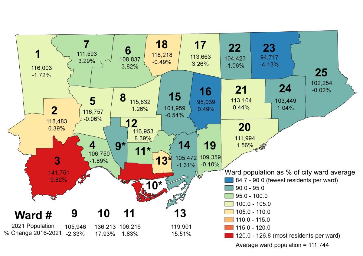
With the release of the 2021 Census population data, the disparities within federal ridings and City of Toronto wards become quite stark
2014 was a watershed year for municipal voter turnout in Toronto. After a disastrous four years of Rob Ford as mayor, 54.7 percent of all eligible voters went to the polls, electing John Tory. That was the highest voter turnout in decades, even higher than 1997, when Torontonians elected Mel Lastman to lead a newly […]
At the end of 2014, despite some disappointing results in that year’s municipal election, I was feeling optimistic about 2018. In 2014, there were a number of great candidates running for city council, and I expected many would try again in 2018. After council finally approved the recommended 47 ward model for the 2018 election, […]
In the penultimate post in my series examining the results of the 25 council races in the October 2018 municipal election here in Toronto, I take a look at the results in Ward 4, Parkdale-High Park and Ward 9, Davenport in Toronto’s west end. Neither of the two ward-level results were surprising. Ward 4 returned […]
Happy holidays! In this post, I take a look at the council races in Ward 15 Don Valley West and Ward 16 Don Valley East. The new two wards, introduced under Bill 5, encompass most of what used to be Wards 25, 26, and 34. Ward 25, Toronto’s most affluent under the 44 ward model, […]
In 2014, Scarborough elected ten city councillors. Since that election, one councillor, Ron Moeser, died in office, while two others, Raymond Cho and Chin Lee, resigned to run for provincial office. Cho, representing the Ontario PCs, was successful, while Lee, running for the Liberals, was not. Neethan Shan was elected in Ward 42 in a […]
In this post, I take a look at the council race in Ward 5, York South-Weston. The area, which encompasses neighbourhoods such as Weston, Mount Dennis, Amesbury, and Keelesdale, is one of Toronto’s least affluent. In 2015, York South-Weston’s average household income was $67,954, compared to the city-wide average of $102,721. The area straddles the […]
