2014 was a watershed year for municipal voter turnout in Toronto. After a disastrous four years of Rob Ford as mayor, 54.7 percent of all eligible voters went to the polls, electing John Tory. That was the highest voter turnout in decades, even higher than 1997, when Torontonians elected Mel Lastman to lead a newly amalgamated City of Toronto. In 2010, when Rob Ford was elected mayor, turnout was 50.4 percent, compared to 39.3 percent in 2006 and 38.3 percent in 2000.
Four years ago, the mayoral race was especially competitive. Progressive Olivia Chow was the initial front-runner against Ford, but Tory (who previously ran for mayor in 2003) pulled ahead as Chow’s campaign floundered. Late in the campaign, Rob Ford dropped out due to health concerns, so his brother Doug took his place. Among the three frontrunners, Tory got 40.3 percent of the vote, while Doug Ford took 33.7 percent. Chow only got 23.1 percent. Voters also elected seven new councillors that year, and returned Rob Ford to Ward 2.
After two elections in which over half the number of eligible voters took part, in 2018 voter turnout fell to just 40.9 percent. This was hardly surprising. John Tory cruised to victory despite a challenge by former chief planner Jennifer Keesmaat, while a sudden reduction in the number of wards confused voters and crushed the hopes of many council hopefuls and their supporters.
Though 769,000 electors voted in this mess of an election, voter turnout varied across the city. In Ward 23, Scarborough North, only 34.1 percent of eligible voters turned out to the polls. In Ward 7, Humber River-Black Creek, just 34.6 percent of electors voted. Ward 10, Spadina-Fort York, had the third worst turnout, with just 34.8 percent.
Areas with the highest voter turnout were Midtown and east end Toronto. Ward 14, Toronto-Danforth had the highest turnout, where 49.2 percent of electors cast a vote. It was followed by Ward 15 and Ward 12 (both of which had 48.5 percent turnout) and Ward 19, where 48.4 percent of electors went to the polls.
Wards 12, 14, 15, and 19 had interesting and competitive council races. In Ward 14, the race featured two progressive incumbents, while Ward 19 was one of just two races in which an established city councillor was not running for re-election. Wards 12 and 15 also had competitive races. However, in Ward 4, Gord Perks won re-election easily.
Yet Ward 23 had an open council race in which no incumbent was running. And Ward 7 was one of the most interesting and important races of 2018; this is where Giorgio Mammoliti was finally defeated after years of campaign violations, buffoonery, and embarrassments.
Voter turnout has consistently been low in Toronto’s northwest and northeast corners. In 2014, Ward 8 and Ward 41 (which made up parts of new Wards 7 and 23) had the lowest numbers of electors casting a vote. Turnout was highest in more affluent neighbourhoods, especially in places like Midtown Toronto, the Kingsway neighbourhood in Etobicoke, and in Toronto’s East End. What surprised me mostly was the poor turnout in Ward 10 in 2018.
The difference in voter turnout across the city is more apparent at the neighbourhood level. With the poll-level results available through Toronto’s Open Data Catalogue, I allocated the poll results to each of Toronto’s 140 neighbourhoods, while adjusting the numbers based on the number of votes cast in the advance polls in each ward. The map below shows voter turnout at the neighbourhood level in 2018.
What is immediately apparent is that voter turnout is highest in many neighbourhoods surrounding Toronto’s downtown core, while turnout is lowest in the former City of York, in northwestern Toronto and parts of Scarborough. Areas of high voter turnout tend to be affluent neighbourhoods with high levels of home ownership. These neighbourhoods include the Kingsway, Lawrence Park, Leaside, Cabbagetown, Rosedale, Forest Hill, Swansea, the Beaches, and Leaside. Many of these areas also have active residents’ associations. With Ryerson professor Myer Siemiatycki, I looked at the results of previous municipal election voter turnouts in a report published by the Maytree Foundation.
Downtown, areas with major condominium developments also have lower turnout, especially in places like the Waterfront, CityPlace, Liberty Village, and the Bay Street corridor. These areas are more likely to have younger residents and many renters. Engaging voters both in downtown condos and those living in the inner suburbs remains a challenge. While voter turnout was much higher in 2014 across the city, the same basic patterns are evident. 2014 voter turnout by neighbourhood (alternate version available here)
At the end of 2014, despite some disappointing results in that year’s municipal election, I was feeling optimistic about 2018. In 2014, there were a number of great candidates running for city council, and I expected many would try again in 2018. After council finally approved the recommended 47 ward model for the 2018 election, I was excited. Downtown, which was badly underrepresented under the 44 ward model, would get three additional wards. Vacancies left by departing councillors, including Mary-Margaret McMahon and John Filion, would further improve the chance for fresh new voices to join city council. At least eight wards across Toronto would not have an incumbent running.
Of course, we all know what happened to that dream.
Downtown tends to elect some of Toronto’s hardest-working and most progressive councillors. They’re hard-working out of necessity: old Ward 27 had the largest population in the city, and all four old downtown wards struggled with pressures caused by massive new development and social concerns, especially as older, affordable housing stock is replaced by new condominiums. (Similar pressures exist in North York Centre and Midtown.)
The last council term
In 2014, four councillors were elected downtown. Mike Layton was re-elected in Ward 19, which ran from Dovercourt Road in the west to Bathurst Street in the east, including Exhibition Place, Fort York, and the Mirvish Village redevelopment site at Bathurst and Bloor. Layton was first elected to council in 2010. Layton is the son of respected long-time councillor and federal NDP leader Jack Layton.
Joe Cressy was elected in old Ward 20, which was located between Bathurst Street and University Avenue, and included the Annex, University of Toronto, the Entertainment District, City Place, and much of the waterfront. The previous elected councillor in Ward 20 was Adam Vaughan, who resigned in 2014 to run in a federal by-election in Spadina-Fort York. He is now the Liberal MP for Spadina-Fort York. A long-time political activist, Cressy is the son of former city councillors Gordon Cressy and Joanne Campbell.
Kristyn Wong-Tam was re-elected in Ward 27, which included Rosedale, Yorkville, the Church-Wellesley Village, Ryerson University, and Moss Park. A local business owner and an advocate for both LGBTQ and Asian-Canadian community issues, Wong-Tam was first elected in 2010.
Pam McConnell was re-elected in Ward 28, which included Cabbagetown, Regent Park, the St. Lawrence Neighbourhood, much of the Financial District, and the Distillery District. She was first elected as a Metro councillor in 1994. She is credited for many local improvements, including the Regent Park redevelopment and the revitalized Berczy Park. Sadly, McConnell died in 2017. She was replaced by council appointee Lucy Troisi in a controversial vote.
The promise of new representation
At the beginning of 2018, with three new wards, each of the seven downtown races were starting to shape up.
Mike Layton planned to run for re-election in Ward 19, whose boundaries were similar to the ward he was first elected to in 2010. Joe Cressy planned to run in new Ward 24, and Kristyn Wong-Tam planned to run in Ward 22. Despite her promise not to run for election after her appointment, Lucy Troisi registered to run in Ward 23, against former Liberal provincial cabinet minister and 2010 mayoral candidate George Smitherman. Also running in Ward 23 were Megan Willson, an entrepreneur and community organizer; Khuram Aftab, a local convenience store owner; and Walied Khogali Ali, a progressive community activist in Regent Park and St. Jamestown.
Ward 20 had an especially crowded field of candidates, with eleven council hopefuls. Among the most prominent was local TDSB trustee Ausma Malik, a rising political star. Malik, like other Muslim women and men, faced targeted attacks during the 2014 municipal election. Her win was one of a few bright spots in a nasty campaign season. Malik was backed by many progressives, including Layton and Cressy.
Other high-profile candidates included businessman, transit advocate, and naval reserve officer Kevin Vuong; lawyer April Engelberg; former television journalist and Conservative Karlene Nation; disgruntled restaurateur Al Carbone; second-time candidate Dean Maher, founder of two local neighbourhood associations; and Sabrina Zuniga, federal Conservative candidate for Spadina-Fort York in the 2015 election. Late to register was Han Dong, a local Liberal MPP defeated in the June provincial election. Dong’s entry into the race was supported by former councillor and Liberal MP Adam Vaughan.
Candidates in Ward 21, which encompassed Corktown, the Distillery District, and St. Lawrence Market, included Jennifer Hollett, a former broadcaster and provincial NDP candidate in University-Rosedale; and Suzanne Kavanagh, past president of the St. Lawrence Neighbourhood Association and advocate for local public spaces, including Toronto’s waterfront.
In Ward 25, which included the Yorkville and Church-Wellesley neighbourhoods, there were several well-known candidates, featuring several activists within the local LGBTQ movement. These included Chris Moise, a local Toronto District School Board trustee; Niki Ward, director of the 519 Community Centre; and Ryan Lester, a director of development with the Canadian Centre for Diversity and Inclusion, and former director at Egale Canada.
Downtown voters were spoiled by choice, and there were many worthy and qualified candidates.
But then, of course, Doug Ford seized control of the Ontario Progressive Conservative Party and won the provincial election in June. One of his first acts was to unilaterally cut Toronto City Council to just 25 wards, with the promise to invoke the Notwithstanding Clause of the Charter of Rights and Freedoms to get it past any legal challenge.
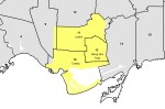
The four downtown wards and their representatives, 2014-2018
The six downtown wards and where each incumbent registered
The three wards under the 25-ward structure, and where each incumbent decided to run. The old four wards highlighted in yellow
Seven downtown wards were reduced to just three. Councillor Joe Cressy decided to run in Spadina Fort-York, while Mike Layton registered in University-Rosedale. Kristyn Wong-Tam ran in Toronto Centre, along with appointed councillor Lucy Troisi.
Many allied progressive candidates, including Ausma Malik and Jennifer Hollett, withdrew their candidacies. Chris Moise decided to run for re-election as TDSB trustee, which he won. Other candidates who withdrew included Han Dong,
Ward 10
There were 14 candidates running in Ward 10, Fort York-Spadina, including Joe Cressy, April Engelberg, and Kevin Vuong. Cressy won with 55.8 percent of the vote, with Engelberg coming in second place with 11.6 percent and and Vuong with 10.5 percent. Cressy placed first in all but seven polls, most of which were condominium buildings in the Harbourfront and Liberty Village neighbourhoods. The top three candidates all supported the King Street Pilot, while Al Carbone got a mere 1.8 percent of the vote.
Poll results in Ward 10
Ward 11
The new Ward 11 was a very different ward from the one in which Mike Layton had run in 2010 and 2014. Only a fraction of old Ward 19 was included in University-Rosedale, which includes neighbourhoods such as the Annex, Yorkville and Rosedale, areas previously represented by Councillors Cressy and Wong-Tam. Layton was challenged by Niki Ward and by latecomer candidate Joyce Rowlands, an occupational health nurse, writer, and policy consultant, and the daughter of former City of Toronto mayor June Rowlands.
Despite the change in ward boundaries, Layton won easily with 69.6 percent of the vote, while Rowlands placed second with 13.2 percent, and Ward in third with 9.1 percent. Layton came first in every poll, but Rowlands did best in Rosedale, almost winning Polls 027 and 029. This was the same area in which Wong-Tam had the least support in 2014.
Poll results in Ward 11
Ward 13
The new Ward 13, Toronto Centre, had much more of former Ward 28 than Councillor Wong-Tam’s old Ward 27. The Rosedale and Yorkville sections of Ward 27 became part of new Ward 11. While Ward 13 is geographically smaller than old Ward 27 (the only instance of this happening under the 25-ward model), it still has a larger population, and has many different challenges than the old ward, as it now includes St. Jamestown, where hundreds remain displaced after a fire, and Regent Park, which is still undergoing redevelopment.
Wong-Tam won with 50.3 percent of the vote, with other high-profile candidates doing quite poorly. George Smitherman got just 15.2 percent of the vote, while Lucy Troisi, the Ward 28 incumbent, got just 8.6 percent. Wong-Tam placed first in all but seven polls, while Troisi didn’t place first anywhere. It’s clear by the poll results map below that Wong-Tam’s support was lowest in St. Jamestown and in the Regent Park neighbourhoods while strongest in old Ward 27 and the area south of Queen Street.
This speaks to the challenges for many councillors elected to new, larger wards. At least Kristyn Wong-Tam is one of Toronto’s most effective and hardest-working councillors, so Ward 13 is in good hands.
Poll results in Ward 13
Conclusion
Downtown Toronto is fortunate to have experienced, dedicated, and hard-working councillors, but concentrating all the work in just three wards is unfortunate. Not only is the population of central Toronto growing faster than most other parts of the city, it has additional needs: an increasing share of the city’s employment that requires additional infrastructure such as a Relief Line Subway, and pressing social needs especially as new development downtown squeezes out affordable rental housing and the institutions that support marginalized people.
I also think of all the great people running for council who never got a fair shot at running for council. Though re-electing Councillors Cressy, Layton, and Wong-Tam is the best result especially considering the circumstances, I was excited by many of the new voices who put their names forward in good faith earlier in 2018. Hopefully, they remain active in the community and get a fair chance in the future.
In the penultimate post in my series examining the results of the 25 council races in the October 2018 municipal election here in Toronto, I take a look at the results in Ward 4, Parkdale-High Park and Ward 9, Davenport in Toronto’s west end.
Neither of the two ward-level results were surprising. Ward 4 returned progressive councillor Gord Perks to City Hall, while in Ward 9, there wasn’t much of a contest: centrist Ana Bailão was easily re-elected.
At the start of 2018, once the 47 ward boundaries were confirmed, it looked as though Bailão was going to be in one of the most interesting council races. The west end of the old City of Toronto — old Wards 14, 17, and 18 — had low population growth compared to many other parts of the city, including northeast Scarborough, North York Centre, Humber Bay Shores, and Downtown. These new ward boundaries were designed to improve representation as the old 44 wards were based on federal ridings drawn in the 1990s. Even with three new wards, the west end would lose a seat on council. The way the boundaries were drawn, it meant that Bailão, elected in Ward 18, would be up against Cesar Palacio, elected in Ward 17.
Differences in 2018 ward populations under the old 44-ward model. Toronto’s west end was one of several areas over-represented by the outdated boundaries.
Under the 47-ward model, it would have been the only race in which two incumbents would have ran against one another and Bailão would have had the advantage.
Palacio, a conservative, was vulnerable in the last few elections, challenged by progressive candidates Alejandra Bravo and Jonah Schein, with Palacio narrowly winning in 2010. With the new boundaries extending south to Bloor Street (the area south of Bloor shifting to join old Ward 14 represented by Gord Perks), Palacio’s base in the north half of his old ward would not have been enough — areas that voted for Bravo in 2014 would have certainly voted for Bailão in a two-candidate race.
After Bill 5 was introduced and confirmed into law, things changed. Sarah Doucette, a progressive councillor representing old Ward 13 (Swansea, Bloor West Village and part of the Junction) withdrew from the race when her ward was joined with Ward 14 (Parkdale and Roncesvalles).
Doucette, who was first elected in 2010, said that she wasn’t interested in serving on a 25 ward council. A councillor well-known for her local community activism, Doucette would have represented a much larger area, and would have run against Gord Perks, someone she describes as a friend. For his part, Perks said that “Doucette deeply embodied the values of decency and community at city council. It’s a crime that we’re losing her.”
Meanwhile, Perks, who was running, still had several opponents in the new larger ward. They included David Ginsberg, owner of several restaurants and a coffee shop near Trinity-Bellwoods Park; Kalsang Dolma, a Parkdale-based artist and community activist; and Evan Tummillo, a property manager who ran against Doucette in 2014. Tummillo was endorsed by the Toronto Sun, while the Toronto Star endorsed Perks.
In neighbouring Ward 9, Cesar Palacio quietly dropped out of the race in late September, only a few days before the new post-Bill 5 nomination deadline. This was a surprise, as he and Bailão had known that they would run against each other for a very long time. Only four other candidates had registered, none of whom enjoyed wide name recognition. Had Palacio withdrawn earlier, it is possible that a progressive candidate would have taken a shot at running against centrist Bailão.
In Ward 4, Perks easily won re-election, taking 44.5 percent of the vote and placing first in all but five polls. Ginsberg placed a respectable second, with 21.6 percent. Ginsberg did best in the affluent Baby Point neighbourhood in former Ward 13, while Dolma did quite well in a few Parkdale polls, placing first in one. Tummillo got just 6.2 percent of the vote, coming first in just one poll, a seniors’ residence on Roncesvalles Avenue.
Poll-level results for Ward 4
Meanwhile, in Ward 9, Ana Bailão got the highest winning margin of any council candidate, taking 83.6 percent of the vote. As the councillor in the old City of Toronto most allied with Mayor John Tory, Bailão has since been named to the executive committee and chair of the new planning and housing committee. Perks, on the other hand, was shut out of Tory’s inner circle.
In this post, I take a look at the council races in Ward 15 Don Valley West and Ward 16 Don Valley East. The new two wards, introduced under Bill 5, encompass most of what used to be Wards 25, 26, and 34.
Ward 25, Toronto’s most affluent under the 44 ward model, was represented by Jaye Robinson, a centre-right councillor. First elected in 2010, she served on both Rob Ford and John Tory’s executive committees. In 2014, she was appointed chair of the powerful Public Works and Infrastructure Committee, whose responsibility includes roads and transportation. Robinson was roundly criticized by road safety advocates (including Walk Toronto, of which I am a co-founder) for a weak “Vision Zero” plan to reduce traffic deaths in Toronto, especially pedestrians and cyclists. 2018 has turned out to be an especially deadly year on Toronto’s streets.
Ward 26 was represented by Jon Burnside, a former Toronto Police officer. In 2014, Burnside defeated incumbent councillor John Parker — the only council race in which a sitting councillor was defeated by a challenger that year. Parker was a Progressive Conservative MPP in Mike Harris’ government, but came to be one of the most effective opponents of the Ford Brothers’ plans for Toronto’s waterfront, and brought a dry wit that was much needed at the time. In the 2014 election, John Tory endorsed Burnside, and Parker was defeated. Burnside had the support of the wealthier Leaside neighbourhood and condo towers off Wynford Drive, while the lower-income Flemingdon and Thorncliffe Park neighbourhoods supported Parker or Ishrath Velshi.
Since the 2014 election, Burnside has proven himself as a thoughtful, moderate conservative.
Meanwhile, Ward 34 was represented by Denzil Minnan-Wong, probably city council’s staunchest and most effective conservative.
Minnan-Wong has been a municipal politician since 1994, when he was appointed to North York City Council. Since 1997, he has sat on Toronto City Council. He’s an advocate of contracting out city services, such as waste collection. Though he supported separated bicycle lanes on Sherbourne, Harbord, Richmond and Adelaide Streets, he quickly moved to scrub bike lanes on Jarvis Street downtown and Pharmacy and Birchmount Avenues in Scarborough. He has been especially powerful during the mayoralties of Rob Ford and John Tory, serving as Tory’s deputy mayor.
In June 2018, Minnan-Wong was nominated by local Progressive Conservatives and ran in the June provincial election. He lost narrowly to the Liberal incumbent, Michael Coteau. Unlike council colleagues Shelley Carroll and Chin Lee, Minnan-Wong did not resign his seat to run provincially.
Under the 47 ward model approved by City Council, each of the three incumbents were poised to run in wards similar to the ones they represented. Only one candidate registered to run against Jaye Robinson in new Ward 27 — Kyle Ashley, a former parking enforcement officer who made a name for himself on Twitter ticketing and shaming motorists blocking Toronto’s bike lanes. He ran against Robinson because of a perceived lack of leadership on Vision Zero. In new Ward 33, Burnside faced a few opponents, but was looking to cruise to re-election.
Meanwhile, Minnan-Wong was challenged by former Liberal MPP and provincial minister David Caplan in new Ward 32. After leaving provincial politics, Caplan served as chair of the Infrastructure Lab and vice-chair of Global Public Affairs Toronto. It would be the first time in many years that Minnan-Wong would face a high-profile opponent.
But then the new 25 wards were imposed on the city.
Ward 15
Ward 15, the provincial/federal riding of Don Valley West, is represented by Liberals both provincially and federally: former premier Kathleen Wynne continues to serve the community, while Rob Oliphant is the Liberal MP.
The new ward boundary, severely disadvantaged Burnside: a significant chunk of old Ward 26, including Flemingdon Park, was now part of Don Valley East. A small part of old Ward 22, between Mount Pleasant Road and Bayview Avenue, was added. Meanwhile, Robinson did not lose any of her old ward. Several candidates, including Ashley, dropped out of the new race.
Burnside placed first in former Ward 26, getting 68 percent of the vote there, and won all three polls in former Ward 22, though by a small margin over Robinson. In Thorncliffe Park, however, Tanweer Khan got over 30 percent of the vote and placed first in four polls. Khan, a local business owner, was an organizer against the updated provincial health and sex-ed curriculum. Khan also ran for the nomination for the provincial Progressive Conservatives PC nomination in Don Valley West, but lost. Khan only got 4.0 percent of the vote ward-wide, but it helped Robinson win.
Robinson took 67 percent of the vote in her former ward. She won Ward 15 overall with 49.2 percent of the vote, to Burnside’s 43.8 percent. Though Robinson will not be part of the Tory’s executive committee this term, she was recently appointed Chair of the Toronto Transit Commission.
What bothers me mostly is not the result, but of the geographic isolation of Thorncliffe Park under the new 25 ward model. It is now a geographically isolated corner of a mostly affluent ward. I fear it, and neighbourhoods like it, will be ignored under a much smaller council.
Poll results in Ward 15
Ward 16
David Caplan was no match for Denzil Minnan-Wong. Caplan was able to get over 30 percent of the vote, but he placed first in just five polls. The combination of Minnan-Wong’s name recognition and incumbency, Caplan’s long absence from provincial politics and his involvement in the eHealth boondoggle (he resigned as Minister of Health in 2009 and did not run in the 2011 provincial election) probably also played a part as well. Caplan did best in Flemingdon Park, a low-income neighbourhood with a large immigrant population that was previously part of Ward 26.
Self-described “pragmatist”Stephen Ksiazek, a local business owner who sits on the Don Mills Residents Association, placed third with 7.1 percent of the vote, coming first in one poll.
Minnan-Wong will serve a second term as Tory’s primary deputy mayor, and will once again set an agenda of low taxes and austerity at City Hall.
In 2014, Scarborough elected ten city councillors. Since that election, one councillor, Ron Moeser, died in office, while two others, Raymond Cho and Chin Lee, resigned to run for provincial office. Cho, representing the Ontario PCs, was successful, while Lee, running for the Liberals, was not. Neethan Shan was elected in Ward 42 in a by-election to fill Cho’s seat. Jim Hart was appointed in Ward 44 by council after Moeser’s death, and Miganoush Megardichian was appointed in Ward 41.
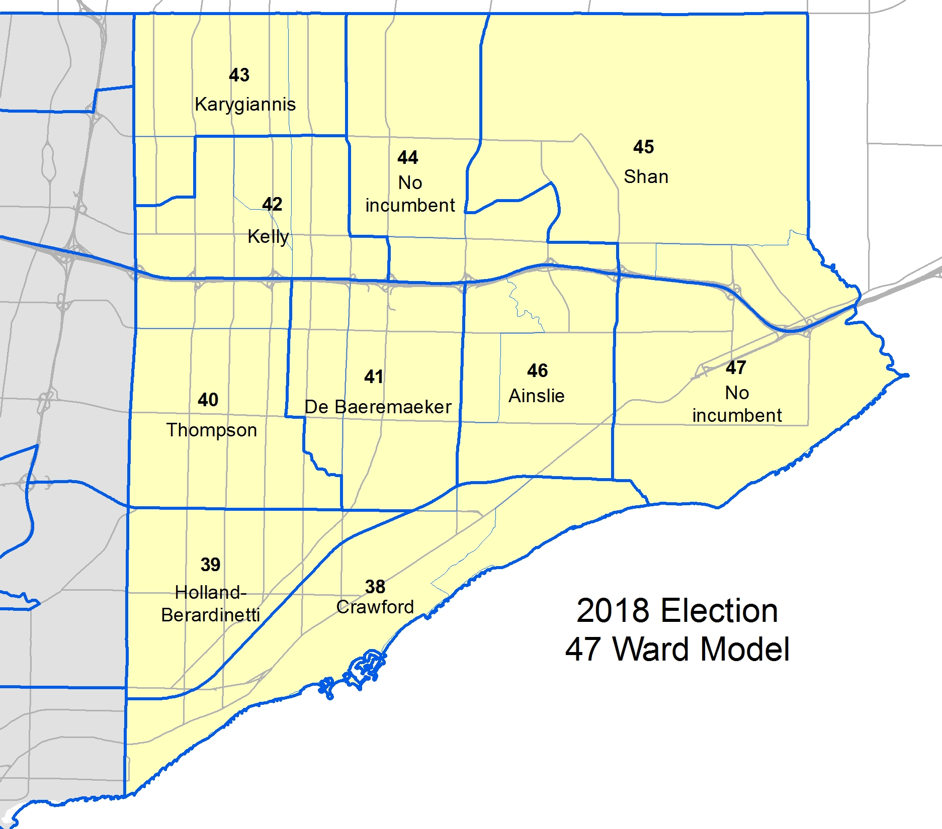
With the new 47 ward model approved by city council for the 2018 election, Scarborough was allocated the same number of wards, though boundaries shifted to reflect changes in population. Two of the new wards – 44 and 47 – had no incumbent running, opening those wards up to new voices.
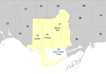
Elected councillors in Scarborough under the 44 ward model
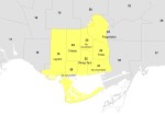
Incumbent councillors in Scarborough under the 47 ward model
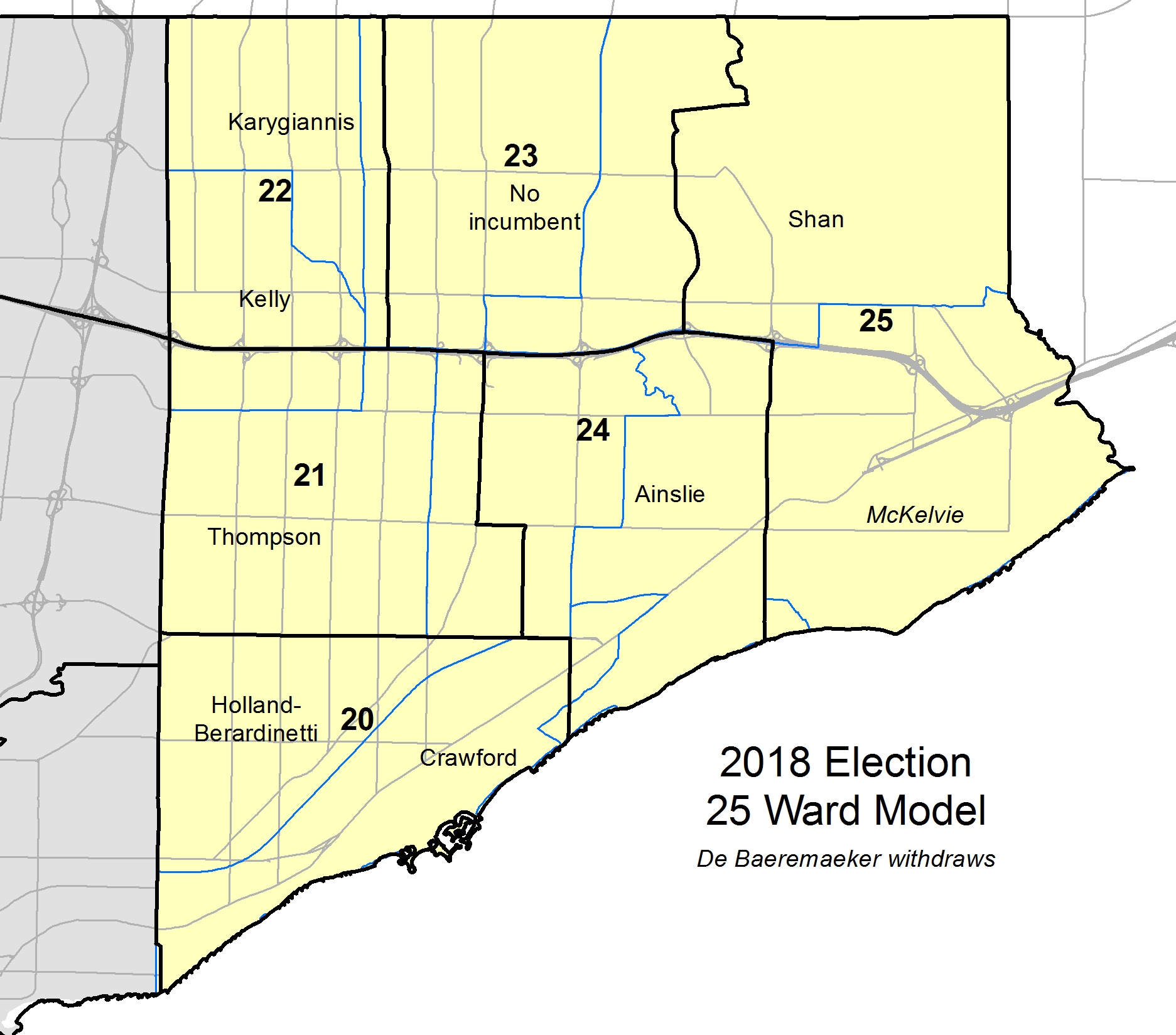
The impact of the 25 ward model
With Premier Doug Ford’s move to cut city council to just 25 wards, Scarborough went down to just six wards. In Wards 20 and 22, incumbents faced off against each other. Councillor Glenn De Baeremaeker, famous for his support of the Scarborough subway extension, decided that the odds were against him and withdrew his candidacy. De Baeremaeker’s old ward was cut in half and redistributed evenly to new Wards 21 and 24. Had he decided to run again, it would have meant running against fellow council veterans Michael Thompson or Paul Ainslie, both of whom had a geographic advantage in not losing any of their former territories.
I previously mapped the results in Ward 22, where Jim Karygiannis defeated Norm Kelly, Ward 23, where conservative businesswoman Cynthia Lai won, and Ward 25, where Jennifer McKelvie defeated incumbent Neethan Shan.
Of the remaining three races in Scarborough, only Ward 20 was interesting. There, incumbents Michelle Holland-Berardinetti and Gary Crawford ran against eight challengers. In Wards 21 and 24, Councillors Thompson and Ainslie won with over 65 percent of the vote and nearly every poll. I did not map the results of those two races.
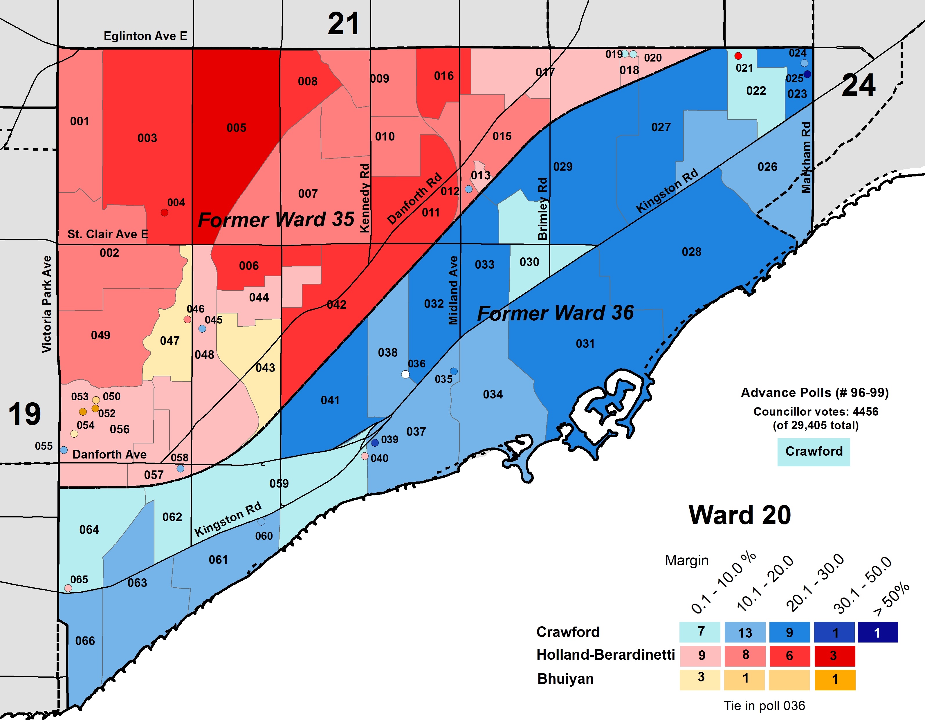
Ward 20
Ward 20 saw two right-leaning councillors, Gary Crawford and Michelle Holland-Berardinetti face off against each other. Both were reliable Tory allies; Crawford served as budget chief under both Rob Ford and John Tory, while Holland-Berardinetti was council’s innovation advocate.
Crawford was first elected in Ward 36 in 2010 after serving as public school trustee. He previously ran for the provincial Progressive Conservatives in 2007. Ward 36, whose southern boundary was Lake Ontario, was Scarborough’s most affluent ward and included the Scarborough Bluffs. Holland-Berardinetti, the spouse of former Liberal MPP Lorenzo Berardinetti, was also first elected in 2010, representing Ward 35. Both councillors were re-elected by wide margins in 2014.
Bill 5 resulted in Wards 35 and 36 merging, with only a small part of old Ward 36 shifting to new Ward 24. The number of voters in each of the two former wards was almost equal, but Crawford won a very a tight race; only 411 votes separated the two incumbents.
Though Mohsin Bhuiyan originally registered to run against Crawford in the 47-ward model, he placed first in five polls in former Ward 35, in the Dentonia Park and Scarborough Junction neighbourhoods. He placed third overall, with 10 percent of the vote, but he drew more votes from Holland-Berardinetti than from Crawford. Suman Roy, a food advocate endorsed by the Toronto Star and NOW Magazine, was only able to get 5.4 percent of the vote, coming in fifth.
Ward 20 Scarborough Southwest
Candidate
Votes
Percent
Gerard Arbour
1,187
4.0
Mohsin Bhuiyan
2,910
10.0
Paulina Corpuz
1,813
6.2
Gary Crawford
10,505
35.7
Michelle Holland-Berardinetti
10,094
34.3
John Letonja
160
0.5
Robert McDermott
367
1.3
Suman Roy
1,582
5.4
Curtis Smith
541
1.8
Bruce Waters
246
0.8
Ward 21
Michael Thompson was first elected to Toronto City Council in 2003. In the 2014 election, he won with over 80 percent of the vote. In the larger new ward, the share of the vote fell to 69 percent. While he’s a thoughtful conservative and a good constituency councillor, Thompson also supported Doug Ford’s unilateral cut to city council.
Ward 21 Scarborough Centre
Candidate
Votes
Percent
Paul Beatty
1,638
6.8
Vivek Bhatt
993
4.1
Fawzi Bidawi
1,035
4.3
Zia Choudhary
1,014
4.2
Randy Bucao
949
4.0
Ismail Khan
311
1.3
Arfan Naveed
349
1.5
Raphael Rosch
545
2.3
Nur Saifullah
132
0.6
Michael Thompson
16,542
69.1
Zamir ul hassan Nadeem
448
1.9
Ward 24
Paul Ainslie was first elected to Toronto City Council in 2006, after being appointed to council in a neighbouring ward in 2005. A principled centrist, Ainslie served on Tory’s executive committee and was re-appointed in 2018. Ainslie won in 2018 with two-thirds of the vote in Ward 24, placing first in all but three polls.
In this post, I take a look at the council race in Ward 5, York South-Weston. The area, which encompasses neighbourhoods such as Weston, Mount Dennis, Amesbury, and Keelesdale, is one of Toronto’s least affluent. In 2015, York South-Weston’s average household income was $67,954, compared to the city-wide average of $102,721. The area straddles the divide between Toronto’s inner city and its postwar suburbs. Mount Dennis will be the western terminus of the Eglinton-Crosstown LRT line, which may bring new development — and gentrification — to the area.
Before Bill 5 was introduced, reducing Toronto City Council to just 25 councillors, the area was made up of two wards, represented by right-leaning council veterans Frances Nunziata and Frank Di Giorgio.
Frances Nunziata has had a long career in city politics. She was first elected to York City Council in 1988 and became mayor of the City of York in 1994, known then for standing up to corruption. When the City of Toronto was amalgamated in 1998, she was one of five former mayors to sit on the new “megacity” council (she was joined by Scarborough’s Frank Faubert, East York’s Michael Prue, Etobicoke’s Doug Holyday, and, of course, Mel Lastman). Nunziata is the last pre-amalgamation mayor still active in Toronto’s government.
While Nunziata supported Barbara Hall’s mayoral campaign in 1997, she backed Rob Ford’s campaign for mayor in 2010. She has served as Council Speaker under mayors Ford and Tory. While I was critical of her role as speaker under Ford’s mayoralty, she has since improved over the last four years. She also known for working very hard for her local constituency. In 2014, Frances Nunziata won Ward 11 with 71.3 percent of the vote and placed first in every poll. Only two candidates ran against her that year.
Meanwhile, Frank Di Giorgio, who represented Ward 12, was elected to North York City Council in 1985, and has been a municipal politician ever since. He was once Rob Ford’s budget chief, but has since served quietly in recent years.
Ward 12 was one of the most interesting local races of the 2014 election, a bonafide four-way race between Di Giorgio, returning challenger and former city staffer Nick Dominelli, former Liberal/Independent MP John Nunziata (Frances’ brother) and Lekan Olawoye, a Nigerian-Canadian immigrant, local community organizer, and talent executive at MaRS. Though Di Giorgio won, only 238 votes separated the incumbent from second-place John Nunziata. Remarkably, all four candidates had the support of over 20 percent of the electorate.
Under the new 47-ward model, there was little change in the boundaries to either Wards 11 or 12. Olawoye had registered to run again in Ward 12 against Di Giorgio. In Ward 11, Nunizata’s re-election bid was challenged by Chiara Padovani, a community activist and social worker. Padovani’s platform sought to address housing affordability, poverty and a lack of community services. The race was marked by bitter disputes between the Nunziatas and Padovani.
When city council was slashed to 25 wards, former Ward 11 and Ward 12 were combined into the new Ward 5. Most candidates, including Nunziata, Di Giorgio, Olawoye, and Padovani, ran in the new larger area. Unlike other wards where two incumbents faced off against each other, neither Nunziata nor Di Giorgio lost any part of their former constituencies. Nunziata still had the advantage, however, as there were more polls and voters in former Ward 11 than in old Ward 12.
Progress Toronto endorsed both Padovani and Olawoye, while Olawoye got the endorsement of the Toronto Star and the Toronto and York Region Labour Council. The Toronto Sun endorsed Nunizata.
Results of the council race in Ward 5
Nunziata won Ward 5, taking 32.2 percent of the vote, while Di Giorgio placed second, netting 21.7 percent. Padovani came in a close third, with 20.5 percent, while Olawoye took 14.9 percent. Both incumbents placed first in their old wards. Padovani got over 25 percent of the vote in old Ward 11, where she originally registered, coming in second there.
Combined, the two progressive candidates got over 9,000 votes, more than Nunziata’s winning total of 8425. Change may yet come to York South-Weston in 2022.
Ward 5 York South-Weston
Candidate
Votes
Percent
Keaton Austin
467
1.8
Deeqa Barre
1,172
4.5
Joey Carapinha
241
0.9
Frank Di Giorgio
5,674
21.7
Fred Fosu
245
0.9
Harpreet Gulri
168
0.6
Frances Nunziata
8,425
32.2
Cedric Ogilvie
189
0.7
Lekan Olawoye
3,889
14.9
Chiara Padovani
5,358
20.5
Luis Portillo
352
1.3
Note: I corrected the name of the Toronto & York Region Labour Council
In 2018, Etobicoke went three for three in returning hard-line conservative councillors to City Hall. In Ward 3, Mark Grimes was re-elected despite several controversies, with Mayor John Tory’s help. In Ward 1 and Ward 2, councillors with famous names were re-elected, cementing local political legacies. While the results in Ward 1 Etobicoke North were predictable, the results in Ward 2 Etobicoke Centre were disappointing.
Under the previous 44 wards and the approved 47-ward model, Etobicoke had six seats on Toronto City Council. With the 25 wards forced on the city when Bill 5 came into law, they were reduced to three.
Ward 1 — Etobicoke North
Prior to the new ward boundaries coming into effect, old Ward 1 was represented by Vincent Crisanti. Ward 1 sits in the far northwestern part of Toronto, bounded by Steeles Avenue and Highway 427, as well as the West Humber River to the south and the East Humber River. Its boundaries would not have changed in the 47-ward model.
Crisanti was first elected in 2010, defeating incumbent centrist Suzan Hall. Crisanti was a reliable ally during the first few years of Rob Ford’s disastrous mayoralty. Despite this, he was named one of Tory’s four deputy mayors after the 2014 election. This lasted until September 2017 when Crisanti publicly backed Doug Ford’s plan to run against Tory again for mayor.
Ward 2 was the domain of the Ford family. Rob Ford was first elected there in 2000, and had made a name for himself both for his constituency work and for his outspoken behaviour at City Hall. Ford was on the lone side of many 44-1 votes while David Miller was mayor. He ran for mayor in 2010 and won after Miller decided against a third term; his brother, Doug, was elected in Rob’s place in Ward 2. Doug never had Rob’s personal touch. Instead his time as councillor was focused on enabling Rob’s self-destructive behaviour, creating distractions, and coming up with waterfront land schemes that helped to erode Rob Ford’s authority on council, two years before the crack scandal broke. Doug even declared that his under-served ward had too many libraries and expressed his eagerness to close them, starting a fight with Margaret Atwood.
Early in 2014, his work done, Doug Ford was ready to bow out. Rob and Doug’s 20-year-old nephew, Michael Stirpe, changed his last name to Ford, and registered to run in his uncles’ place. But in September 2014, Rob abandoned his bid for re-election for mayor due to his poor health and Doug ran instead. Michael withdrew in September 2014 to run for the local Toronto District School Board trustee position so Rob could run in his old ward. Rob won in Ward 2 easily, getting 58.8 percent of the vote, while Doug came in second place in the mayoral race.
Toronto would continue to be haunted by Doug Ford.
After Rob Ford’s death in March 2016, Michael Ford ran in a summer by-election, getting 70 percent of the vote, though only 9391 voters bothered to turn out. It was looking like Michael Ford would easily win again in 2018.
But then Doug Ford engineered a takeover of the Ontario Progressive Conservatives, won the June 2018 provincial election, and wrecked local democracy in Toronto by imposing cuts to city council to just 25 wards. Despite his loyalty, Vincent Crisanti was just one more victim.
Michael Ford was re-elected easily in the new combined Ward 1 with 42.3 percent of the vote, compared to Crisanti’s 34.3 percent. Other candidates such as Naiima Farah and Carol Royer spoke to the need for political change in a ward where three-quarters of the population are visible minorities. The Toronto Star endorsed Royer, a local entrepreneur and community activist, but she placed fifth, with just over 2 percent of the vote. Farah came in third, but got just 9 percent of the vote.
Crisanti placed first in his old ward, getting 41 percent of the vote there while Michael Ford got 35 percent. In former Ward 2, Ford got over 50 percent of the vote compared to Crisanti’s 29 percent. Michael Ford had the support of his uncle; there were also over 2,000 more votes in the southern half of the ward. The result was not at all surprising.
Farah placed first in two polls: Poll 055 on Dixon Road, and Poll 060, a highrise apartment near Eglinton Avenue and Martin Grove Road. Poll 055 is the home of many new immigrants, including a large Somali-Canadian community. Yet again, it was a shame that new voices, especially persons of colour, were shut out of this municipal election.
Poll-level results in Ward 1, Etobicoke North
Ward 2 — Etobicoke Centre
Bill 5 also resulted in the amalgamation of former Wards 3 and 4.
Ward 3 was represented by Stephen Holyday, the son of former Etobicoke mayor, Toronto councillor ,and one-time Ontario PC MPP Doug Holyday. The younger Holyday was first elected in 2014 and has been a reliable ally of John Tory, named one of Tory’s deputy mayors after Crisanti was stripped of the title in 2017. Along with Denzil Minnan-Wong, Holyday is one of council’s staunchest conservatives, as well as its most hostile to cyclists.
Ward 4 was represented by John Campbell, a former chair of the Toronto District School Board. While a conservative, Campbell has been a more reasoned voice on city council than his fellow Etobicoke colleagues. For this reason, Campbell was endorsed by the Toronto Star.
Also running were progressive candidate Erica Kelly, previously the NDP candidate in the provincial election, and Angelo Carnevale, who had the support of Doug Ford and Kinga Suma, the controversial Ford-backed PC MPP.
Several polls previously located in old Ward 4 shifted to new Ward 1, while five polls in old Ward 2 shifted to Etobicoke Centre. This gave a slight advantage to Holyday, who did not lose any of his former ward.
It was a close race, but Holyday won with 38.6 percent of the vote, while Campbell got 35.5 percent. Just 1186 votes separated the two incumbent candidates. Holyday was the first choice in all but two polls in former Ward 3 (two polls opted for Erica Kelly), while in former Ward 4, Holyday placed first in nine polls, Campbell placed first in just 28 election-day polls, but did well in the advance polls.
Carnevale, who placed third with 15.1 percent, came first in just one poll, in an area previously represented by the Ford family. But Carnevale, who registered to run against Campbell in the old 47-ward model, helped to take support from Campbell, getting 20 percent of the vote in Campbell’s old turf versus 11 percent in former Ward 3. That, and the fact that there were nearly 3000 more voters in old Ward 3 than in old Ward 4, help to explain how Holyday was returned to city hall.
Last week, Stephen Holyday was one of four suburban councillors named to the new striking committee that makes recommendations for council appointments to important committees, boards, and commissions. It’s quite clear that John Tory will be continuing an austerity agenda while shutting out urban councillors and progressives from decision making. Stephen Holyday will be an important part of that during the next four years.
Ward 14, Toronto-Danforth, was another ward where two progressive incumbent councillors were forced to run against each other when Toronto City Council was reduced due to Bill 5. Mary Fragedakis represented old Ward 29, the part of the ward north of Danforth Avenue, while Paula Fletcher represented old Ward 30, south of the Danforth. Both are affiliated with the New Democratic Party.
Fragedakis was first elected in 2010, replacing retiring councillor Case Ootes, a conservative. In that election, she got 41.8 percent of the vote, well ahead of her closest challenger, Jane Pitfield. In 2014, she won every poll in Ward 29 and got almost 60 percent of the vote. Fragedakis would have very likely been re-elected in Ward 34 under the 47-ward model, despite the new ward boundary encompassing Rosedale. There were three challengers: Marisol D’Andrea, Ryan Lindsay, and Alexander Pena.
Paula Fletcher was first elected in 2003, taking Jack Layton’s former seat on council. She nearly lost in 2010 to Liz West, a more conservative candidate, but increased her vote share in 2014, taking 49.6 percent of the vote against West and new challenger Jane Farrow. Fletcher intended to run again in the new Ward 36, which had similar boundaries to her old Ward 30. There were also three challengers: Lanrick Bennett, Chris Budo, and Dixon Chan.
Under the new 25 ward model, the old Wards 29 and 30 were combined, along with a small section of old Ward 32. Only Alexander Pena withdrew from the race.
Fletcher was endorsed by the Toronto Star and by the Toronto and York District Labour Council. The Labour Council endorsement was controversial, as its president, John Cartwright, is married to Fletcher. Fragedakis was also previously endorsed by the Labour Council, so it would have been only right for it to withhold its endorsement in Ward 14.
In any case, the Labour Council’s endorsement wouldn’t have mattered. Fletcher won by a wide margin, netting 42.3 percent of the vote, compared to Fragedakis, who came in second place with 26.2 percent. In third place with 19.0 percent of the vote was 22-year old Chris Budo, a financial analyst who recently graduated from Ryerson University. Budo came in second place in 32 polls, and placed first in Poll 005.
Fletcher was able to count on the support of polls in her home turf. She got 55.7 percent of the vote in former Ward 30, while Fragedakis was only able to get 44 percent of the vote in old Ward 29. There were also over 3500 more voters south of Danforth Avenue than to the north. As we have seen previously in Wards 6, 8, 22, and 25, when two incumbents ran against each other, the advantage was given to the candidate whose former turf has the larger population in the new ward.
Paula Fletcher is a hardworking and effective member of Toronto City Council, pushing for affordable housing, social justice and environmental issues, and is very attentive to her community. I am glad that she is back on council. But I remain disappointed and disillusioned by the province’s meddling in local affairs that shut out both good incumbents and promising young voices.
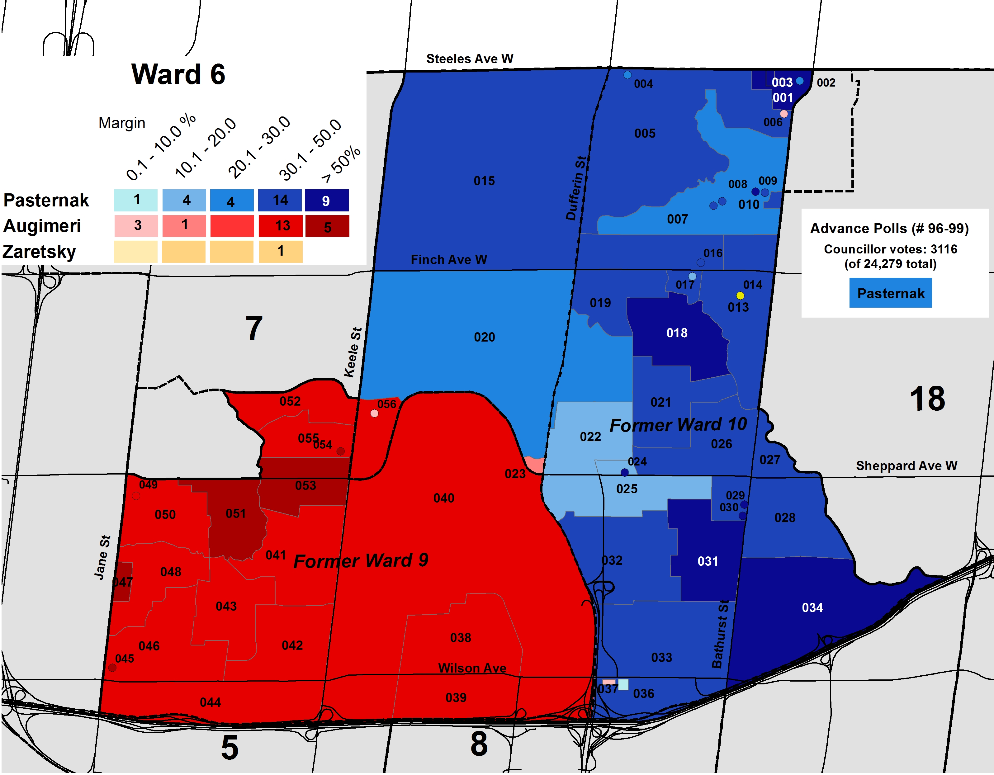
Premier Doug Ford’s decision to reduce the number of councillors on Toronto City Council from 47 to 25 resulted in some very disparate new wards. New Ward 6, York Centre, combined two very different wards. On the west side of Allen Road, in old Ward 9, there are large Black and Italian communities, while on the east side of Allen Road, in old Ward 10, the population is largely Jewish, Filipino, and Russian.
James Pasternak represented Ward 10. Previously a TDSB trustee, Pasternak was first elected in 2010 after incumbent councillor Mike Feldman retired. A conservative, Pasternak is best known for supporting a western extension of the Sheppard Subway through his ward and for opposing city funding to Pride while allowing Queers Against Israeli Apartheid to march in the annual parade.
Maria Augimeri, who represented Ward 9, was first elected to North York City Council in 1985 and has since served on the old Metropolitan Toronto council until amalgamation in 1998. Since then, she has represented the Downsview neighbourhood on City of Toronto Council. She was nearly defeated in the 2010 election by conservative Gus Cusimano, but won with a comfortable margin in 2014. Augimeri is a New Democrat; she ran for the provincial NDP in 1987, and she has a progressive voting record on Toronto City Council.
Augimeri sought re-election in Ward 9 under the 47-ward model, but found herself against a high-profile challenger, Louise Russo. Russo was the unintended victim of an organized crime-related shooting in 2004 and has since become an anti-violence advocate. She was Mayor John Tory’s special guest at the inaugural council meeting in 2014 just after he was elected mayor.
Meanwhile Pasternak sought re-election in Ward 10, whose boundaries were identical under the new ward structure. His highest-profile opponent was Edward Zaretsky, an 84-year old resident who’s notable for parking his minivan in front of a pothole in protest earlier in 2018. Zaretsky has been an outspoken critic of Pasternak.
When Bill 5 came into effect after a failed court challenge, old Wards 9 and 10 were combined in Ward 6. A small section of old Ward 9 near Jane Street and Sheppard Avenue moved to Ward 7, while the area north of Sheppard Avenue between Keele and Dufferin Streets was added from old Ward 8.
There were only four candidates running in the new larger ward. Despite their ideological differences, Augimeri and Pasternak both described the new race against each other as “unfortunate” and “respectful.”
In the end, James Pasternak won the local council race with 47.6 percent of the vote compared to Maria Augimeri’s 38.0 percent. Louise Russo got 11.2 percent (but did not place first in any polls), while Edward Zaretsky got just 3.2 percent, but placed first in Poll 14, a seniors residence.
The map above shows the polarized electorate in Ward 6. Augimeri placed first in all 19 polls located in former Ward 9, while Pasternak placed first in all but three of the 34 polls in old Ward 10. In the 19 polls located in old Ward 9, Augimeri got 61.5 percent of the vote, while Pasternak got 18.6 percent and Russo got 18.3 percent. Meanwhile in old Ward 10, Pasternak took 64.3 percent of the vote, followed by Augimeri with 24.4 percent and Russo with 7.3 percent.
Russo likely cut into Augimeri’s support at the polls, but her candidacy was largely squeezed out in a two-incumbent race. What ensured Pasternak’s win most of all was simply an imbalance of population: there were more voters (12,340 election-day votes) in old Ward 10 than in old Ward 9 (8156 election-day votes).
Because of the diverse demographics and geographic configuration of Ward 6, it might be attractive to high-profile candidates looking to run for council in 2022. Who knows what might happen in four years?
When Toronto adopted a 47-ward model for the 2018 election, North York was going to get one of the three additional wards. North York Centre, the section of Yonge Street between Highway 401 and Steeles Avenue, is one of the fastest growing parts of the city. New condominium towers have gone up along the Yonge and Sheppard Subways, bringing in thousands of new residents.
John Filion, councillor for old Ward 23, was one of Toronto’s hardest-working politicians. Not only did he have to represent thousands more residents than most of his colleagues, he also had to keep on top of dozens of planning applications. It was probably with relief that he announced his retirement in June. He endorsed two successors for the new wards comprising his old turf: Markus O’Brien Fehr (his executive assistant) in the new Ward 28 and Lily Cheng (a local community organizer) in the new Ward 29.
Meanwhile, it looked as though fellow council veteran Shelley Carroll was also leaving City Hall. Earlier this year, she resigned as councillor in old Ward 33 to run as a Liberal in the June provincial election, creating a potential opening in new Ward 31. Fellow Liberal Dan Fox was poised to make another run against David Shiner in Ward 30. It looked like things were going to get interesting in North York.
But then the Progressive Conservatives were elected to Queen’s Park, and Carroll lost in Don Valley North. At the end of July, Doug Ford’s provincial government introduced Bill 5, reducing the number of wards from 47 to 25.
The four wards drawn up for the part of North York east of Bathurst Street and north of Highway 401 was reduced from four to two. While David Shiner retired from municipal politics, it left hopeful Dan Fox without an open seat to run in. Much of former Ward 24, where Fox ran in 2014, was encompassed by Ward 17, Don Valley North. This is where Carroll was going to try to return to council.
The council appointee that replaced Carroll in old Ward 33, Jonathan Tsao, had promised not to run for re-election. Challengers to Carroll in Don Valley West included former TDSB trustee Ken Lister and anti-sex education activist Christina Liu. In total, there were eight candidates running in Ward 17.
Carroll won easily, netting just over 40 percent of all votes cast. Liu placed second with 29 percent of the vote. Carroll did very well in the southern part of the newly enlarged ward, though Liu won 14 polls, mostly in the northwest, and tied Carroll in Poll 32.
Poll-level results in Ward 17
In Willowdale, John Filion jumped back into the race, claiming that the lack of an incumbent would allow a candidate tied to land speculators to win. While Markus O’Brien Fehr stepped aside, Lily Cheng did not.
Other candidates in Willowdale included Norm Gardner, a former Metro councillor and police board chair; Saman Tabasinejad, the New Democratic candidate for Willowdale in the provincial election; businessman Sonny Cho; Sam Moini, a pro-Doug Ford candidate who was known for his advocacy on behalf of taxi owners and drivers; and David Mousavi, a lawyer who came in second to Filion in the 2014 election. There were 18 candidates in total.
Filion came in first place, with just 31.1 percent of the vote. Cheng placed second with 19.7 percent, and Cho came in third with 12 percent. Cheng placed first in 25 polls, especially along the Yonge Street corridor.
While John Filion has been an effective progressive councillor, especially during the Rob Ford years, his decision to jump back in the race, threw Cheng under the metaphorical bus. Had he committed to retiring but made a strong effort to support her campaign, I believe that she would have won. Conservative candidates like Mousavi and Moini were unable to get more than 10 percent of the vote; it appears that Filion’s fears were unfounded.


 Poll results in Ward 11
 Poll results in Ward 13

 Poll results in Ward 15
 Ward 16 poll results
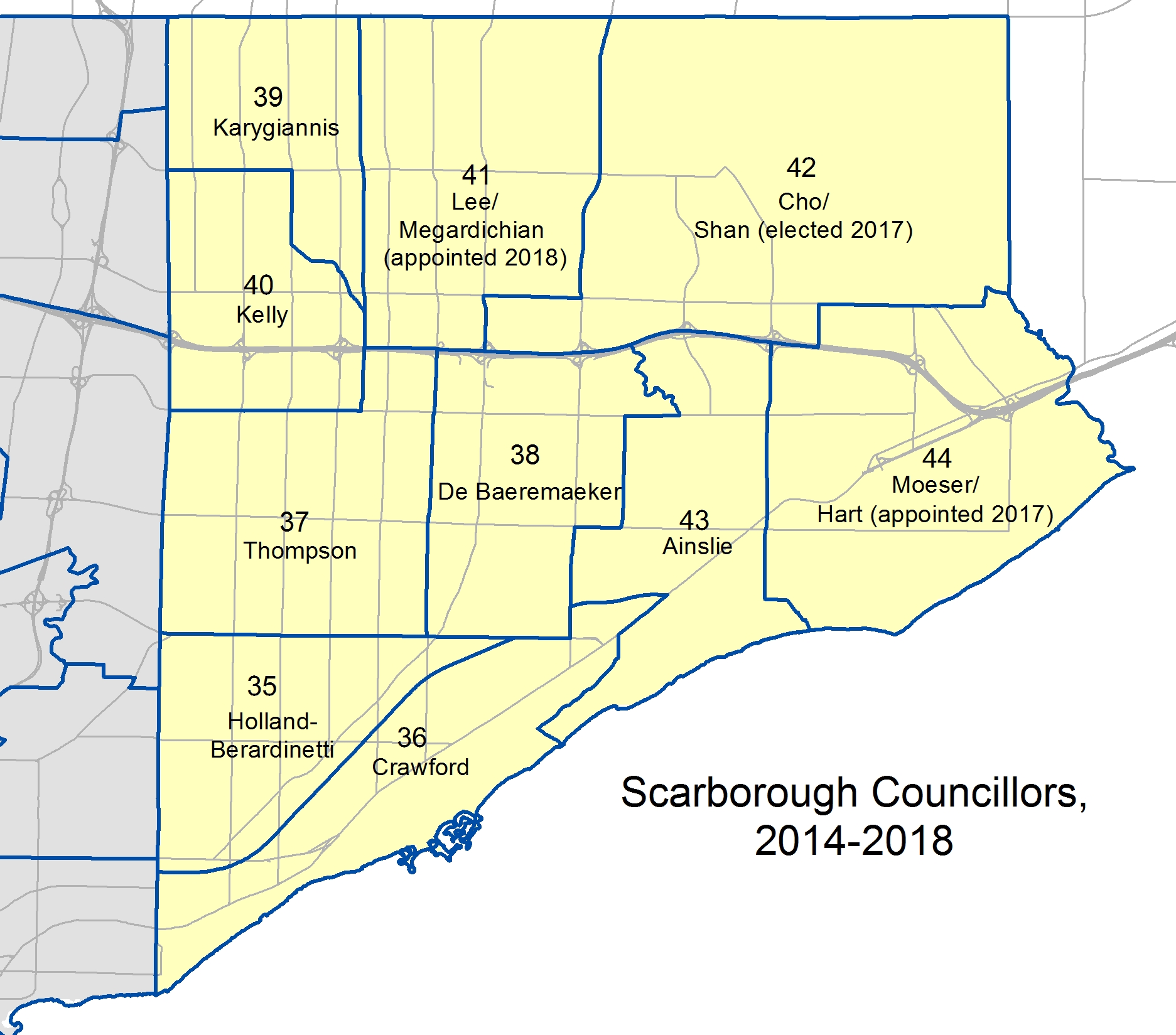
 Results of the council race in Ward 5
 Poll-level results in Ward 2, Etobicoke Centre