Extensions to Montreal’s REM has resulted in some regional route changes in the Montreal area
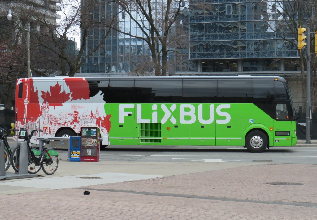
In time for summer, I have updated my Canada Intercity Transportation Map to include new connections and revisions. The only major changes to the intercity coach layer are new routes operated for Flixbus, including new seasonal routes from Toronto to North Bay and Prince Edward County.
In Quebec, the opening of the Deux-Montagnes and Anse-à-l’Orme branches of the REM in Greater Montreal resulted in several long-distance Exo regional bus lines cut back or replaced in favour of local bus routes feeding into the new regional rail service. Therefore, I have decided to remove Exo bus routes from the map where they exist entirely within one or two urban transit zones, being consistent with the municipal transit agencies surrounding Toronto. However, long-distance express routes and routes that serve Montreal’s outer periphery will remain on the map as part of the regional route layers.
In addition, I have also included a few new and previously overlooked services operated by the MRCs (municipalités régionale de comté), including taxibus service areas, which operate similarly to on-demand transit elsewhere in Canada, but have posted stops and semi-fixed schedules; many of these require preregistration before reserving a ride. Where taxibus services operate, I have opted to include those as on-demand, rather than fixed route lines to be consistent across Canada. Only on-demand and taxibus services that are open to the general public are included in the map.
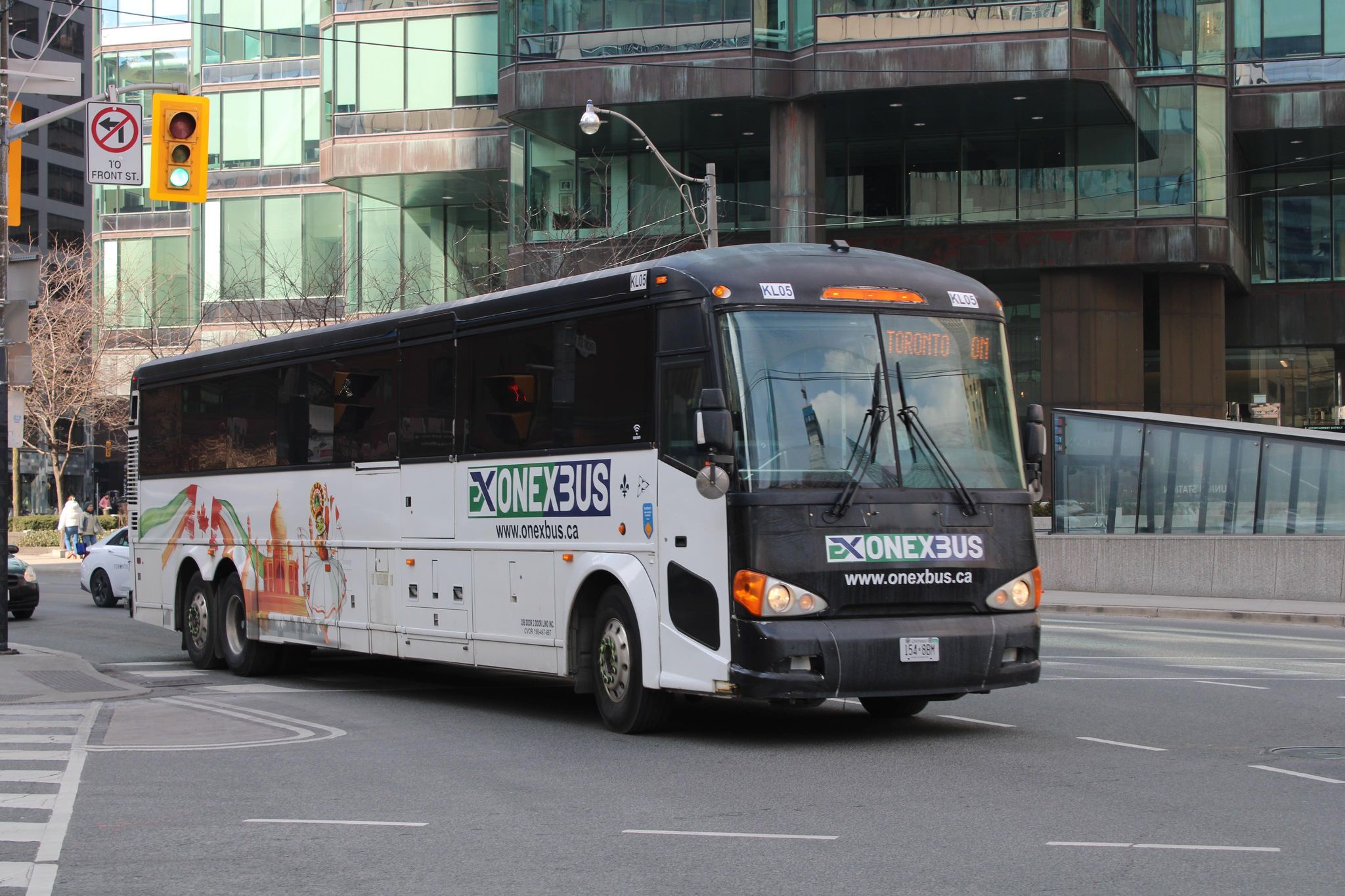
Onex Bus changed its schedules recently, eliminating most departures from Brampton Gateway
Mapping smaller intercity coach operators continues to be challenge, as deregulation in Ontario and Western Canada and online ticketing have made it harder to track changes in schedules and stop locations, though I have noted some changes with Onex Bus’ schedules, which ended most trips to and from Brampton Gateway Terminal at Main and Steeles earlier this year.
Previously, carriers like Greyhound would publish detailed schedules that were valid for at least a few months at a time, including holiday and school break special runs; Ontario Northland and Quebec-based carriers (where provincial regulation remains in force) at least maintain consistent schedules. As it is much harder to track this industry — with no central database — I always appreciate the contributions website visitors provide by email or social media. I thank everyone who has helped so far.
Unfortunately, the costs of maintaining this website and the ArcGIS Online portal to my maps continue to rise. However, I am committed to provide an ad-free, paywall-free resource. If you enjoy my work, please consider buying me a coffee to help with those costs. Thank you!
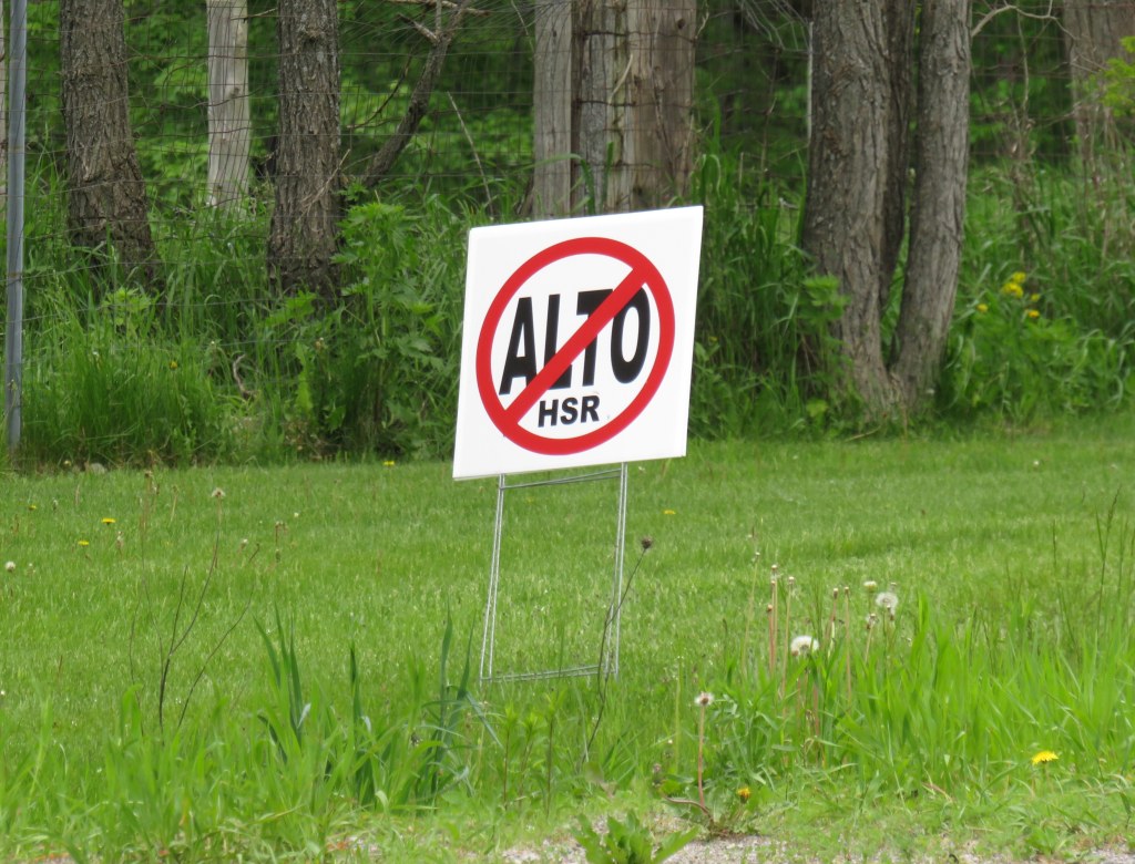
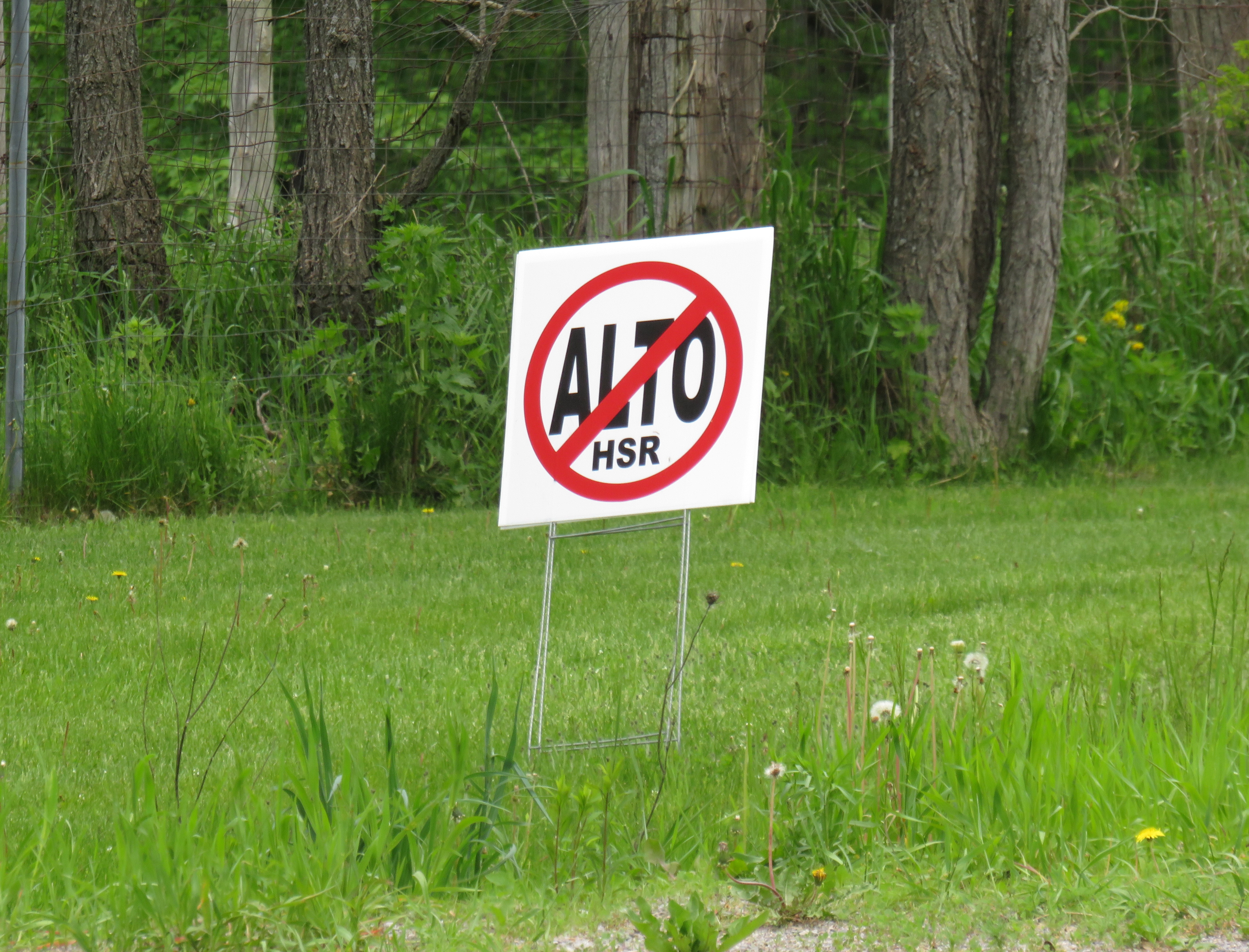
A “No ALTO HSR” sign on a property near Marmora, Ontario
There’s a running joke that Canada leads the world in high speed rail studies, but we never follow through with actually building those high speed lines. Comedian Rick Mercer had at least two sketches on his old weekly CBC television show mocking this state of affairs, as the idea goes back to the 1970s.
“VIA Rail: Yesterday’s speeds, today.”
“Canada’s High Speed Rail Study Industry: The future, never!”
In 2026, however, Canada is finally past the high speed rail study phase and appears to be committed to building the seven-station corridor between Toronto, Ottawa, Montreal, and Quebec City, with a consortium selected that is already planning the detailed route. It’s an exciting time as the first phase, between Ottawa and Montreal, should start construction in three years once the exact corridor is decided upon and land acquisition has begun.
High speed rail, if done right, should benefit Eastern Canada as a whole. Fast and frequent train service will divert a lot of the travel in the busy Toronto-Montreal-Ottawa triangle from the air, reducing emissions and allowing existing airports to handle any increases in long-haul demand. Faster and more reliable passenger train service would also take traffic off the highways and boost commerce within the most populated part of the country. If done right, it will also support plans for better transport infrastructure outside the corridor to Southwestern Ontario and provide Canadian expertise for other projects such as in Alberta, which is contemplating its own passenger rail network between Calgary and Banff and north to Edmonton.
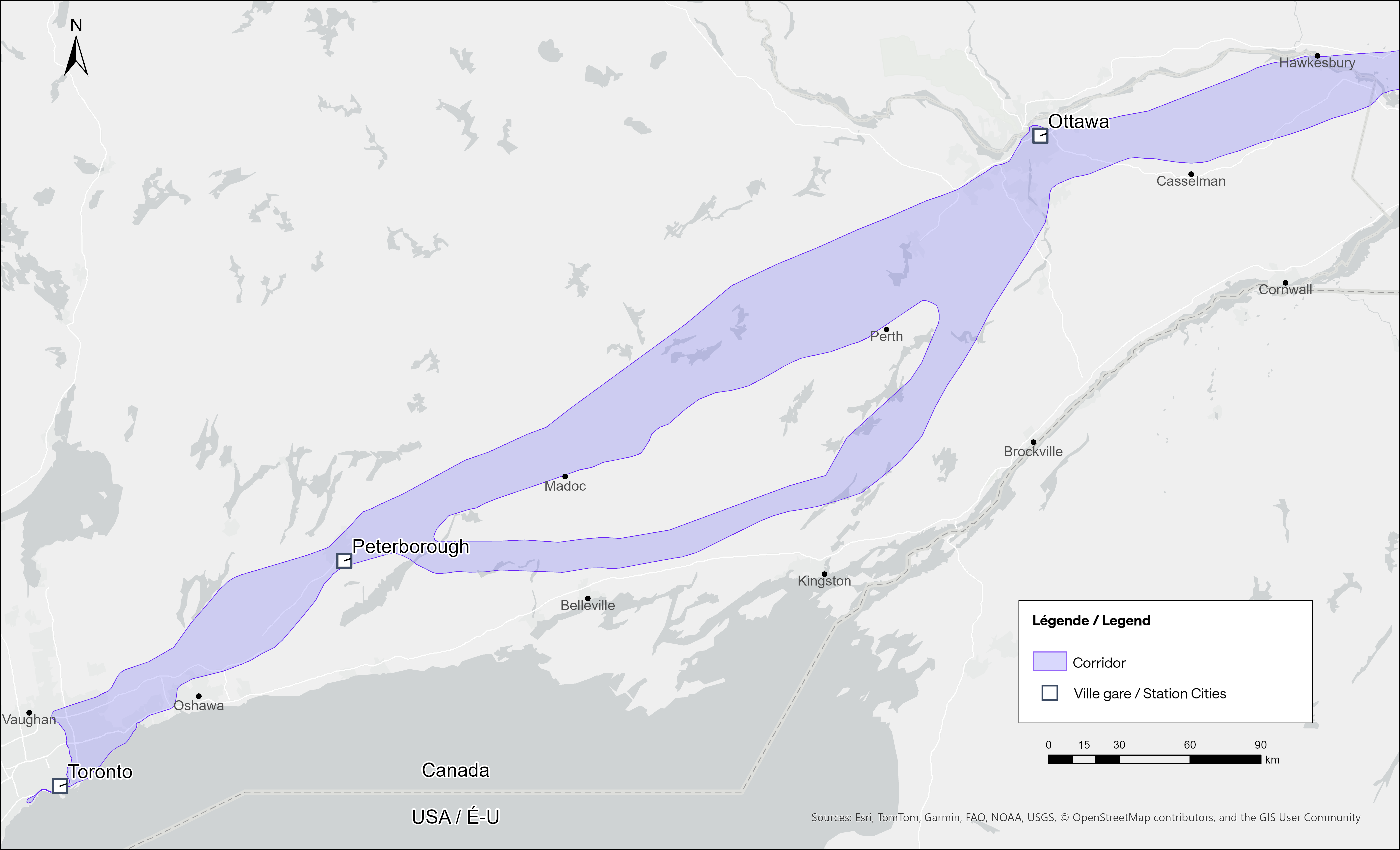
Map of potential routings for the Alto high speed line in Ontario
Not unexpectedly, there is opposition from residents and landowners along the route, especially in Eastern Ontario and the area of Quebec just northwest of Montreal. In Hastings County, north of Trenton and Belleville, there are a few dozen “No Alto HSR” signs on lawns and farms in places like Madoc, Marmora, Stirling, and Tweed. In this part of Ontario, between Peterborough and the Rideau Lakes region southwest of Ottawa, there are two broad potential routes: a southerly corridor runs near Campbellford, Stirling, Tweed, and Westport, including through some productive farmland in Northumberland and Hastings Counties. A second route runs north of Highway 7, just north of Madoc and Perth, along the southern fringes of the Canadian Shield.
Though a high speed railway line would be straight and relatively narrow, it would require the acquisition and severance of hundreds of properties. Along the existing CN and CP railway corridors to the south constructed in the 1850s and 1900s, there are frequent public road and private-access level crossings, something that is not possible with modern high speed trains passing at up to 300 kilometres per hour, so farmers whose land is crossed by the new high speed railway corridor may not be able to access parts of their property easily. Furthermore, there are no stops planned between Peterborough and Ottawa, a distance of over 250 kilometres.
In Prescott & Russell Counties in the Lower Ottawa Valley, even the local governments are opposed to Alto crews doing early survey work to determine an optimum route, with county warden Mario Zanth clear on the matter: “This council does not want them on our territory.” For now, Alto surveying is mostly done by way of drones over land where landowners have not granted access.
Once a more specific route is selected, hopefully some of the opposition will fade. Detailed design work and further consultation should also help mitigate concerns. This is especially important west of Ottawa, where there are the two diverging routes.
Despite the rural opposition, Alto should go ahead. Other major infrastructure projects, especially new highways, can be far more disruptive to local land use. But without local community benefits — at least a new freeway has regular access points — it will be harder to get buy-in.
Therefore, this needs to be a matter of “Alto and” than just “Alto” by itself. This means building and maintaining a supporting network of conventional VIA service, intercity and regional buses, and local transit connections. It might also mean adding a few additional stations along the route, in places such as Perth. Adding additional stops doesn’t have to slow down trains at all; Japan’s Shinkansen has three classes of trains, from the super-express Nozomi to the all-stops Kodama. While most passengers would be through Toronto-Ottawa-Montreal travellers, offering additional stops for select trains can make Alto more accessible to more people, especially if it means providing new options to underserved communities.
An express train passes the local Odawara Shinkansen Station in April 2019
If Alto becomes the backbone of a strong, integrated transportation network in Ontario and Quebec, the benefits will go far beyond those in the six cities directly served the planned high speed line, even to those directly bypassed by Alto trains. This integration is commonplace in Japan and Europe.
In Kingston, for example, a new or upgraded VIA station with additional tracks and platforms would allow for early morning departures and late evening arrivals from Toronto, Ottawa, and Montreal without having to sit on active CN freight tracks overnight; VIA schedules built around serving cities like Belleville, Kingston, and Drummondville would ensure the existing service remains vital as through passengers switch to the faster line. A new Kingston station near Division Street could integrate rail and bus services, with easy access to Highway 401, with local and regional buses to places like Gananoque. Enhanced bus connections to the rest of the Ottawa Valley from the Ottawa Alto/VIA Station could allow travelers from Pembroke, Arnprior, or Hawkesbury to quickly continue their journeys via train. At Trois-Rivières, there should be seamless connections to places like Shawinigan and Victoriaville. The Canada Intercity Transportation Map on this website shows which communities are unserved or underserved by bus and rail: these include many towns in Southern Ontario and Quebec that are within 100 kilometres of the Alto corridor.
Canada is right to invest in high quality and sustainable transportation infrasturure as a nation-building project, to boost the regional and national economy, and promote environmentally friendly travel options. But focusing only on Alto, without a strategy of leveraging the conventional VIA network and intercity bus connections to feed that network, can only limit the success of high speed rail. The communities in between deserve better.
In the fifth year that I have been following and mapping Canada’s intercity transportation links, the network (if you could call it that) remains in flux. Spring 2026 brings several new routes, particularly in Western Canada, that restore some former Greyhound services. Unfortunately, regional and commuter services in Ontario and Alberta are coming to an end. Wednesday, April 30 was the last day for the LTW Route 42 between Leamington and Windsor. In Alberta’s On-It is winding down its commuter buses between Calgary and Cochrane and Okatoks.
However, Flixbus continues to expand, taking over more former Greyhound routes. Unlike Greyhound or most other intercity transport companies, Flixbus is not a bus company per se, as it does not own or operate the services; instead it uses smaller contracted operators while coordinating branding, schedules, and ticketing. But starting in May, it will operate three-four days a week between Calgary, Regina, and Winnipeg, with stops in cities that have long been without service, such as Moose Jaw and Swift Current. Another route will connect Calgary with Drumheller, including a stop at the famous Royal Tyrrell Museum.
Despite the recent loss of TOK’s Southampton route and last year’s cutback of Grey County’s GTR services, there is hope for new connections in Midwestern Ontario. Grey County, together with neighbouring Bruce, Dufferin, and Wellington Counties, is studying a regional system to augment and replace the limited existing services. Hopefully, it will include regular service to fast-growing Saugeen Shores, which recently lost that TOK service. In Centre Wellington, a new local service connecting Elora and Fergus will soon start operations.
One of the major issues continually faces is the lack of intramodality and useful connections. A viable passenger rail system — be it a classic corridor service such as the Quebec-Windsor VIA train or a high-speed line such as the planned ALTO project — is much more useful to many more passengers when there are easy connections at stations. Through-ticketing and schedule coordination should be implemented whenever possible. Furthermore, though the Upper Ottawa Valley (towns and cites such as Renfrew and Pembroke) has a daily Ontario Northland bus, it arrives in Ottawa late in the evening and leaves early in the morning, limiting its usefulness to areas closer to Ottawa that could benefit from a commuter connection or onward trips to Montreal, Toronto, or Kingston. Despite more gaps seemingly filled, other gaps remain.
With planning now well underway for the Alto high speed passenger rail corridor between Quebec City and Toronto, there has been some speculation that Ottawa’s grand old Union Station, in the heart of the capital’s downtown core and a mere stone’s throw from Parliament Hill, could see trains again. Local business leaders and Mayor Mark Sutcliffe are excited by the idea of a downtown station, expecting that a downtown transport hub would help revitalize the local economy. Though it’s a very attractive idea, there are unfortunately just too many reasons why this would not be feasible.
To understand why, it’s worth diving into the history and urban politics of railways in the National Capital Region.
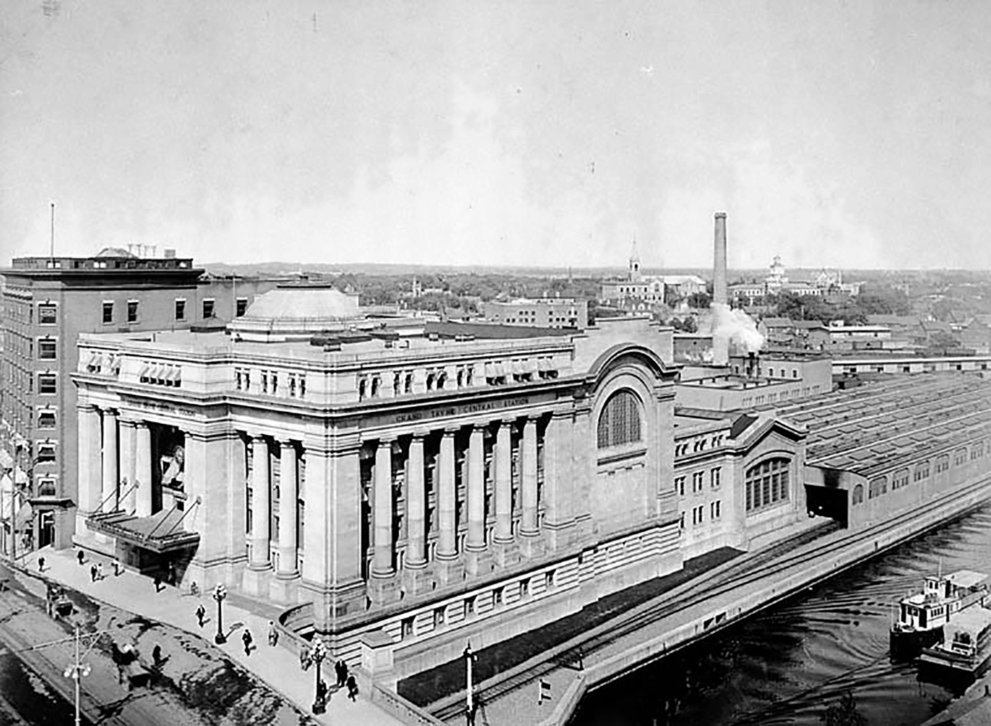
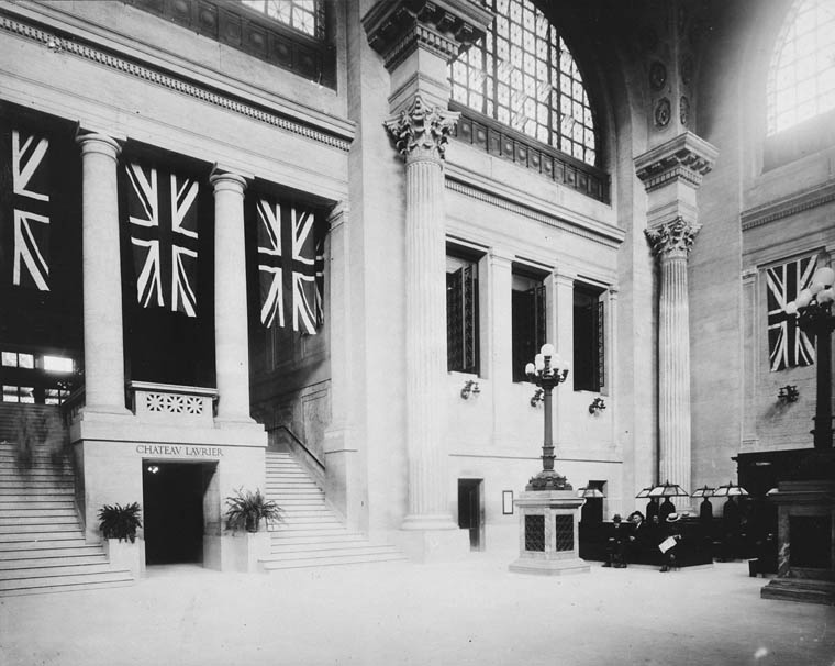
The Grand Trunk Central Station, opened in 1912, provided a grand entrance to Canada’s capital city that was previously served by a few smaller stations just outside the downtown core. The station, designed in the Beaux-Arts style, was built as a stub-end terminal. This meant that trains would arrive and depart from the south and would have to be backed up to change direction. This suited the Grand Trunk Railway just fine, as it lined up perfectly with its route to Montréal via Alexandria (still used by VIA Rail today). The railway also built a hotel across the street — the Chateau Laurier — and connected the station with the hotel with a pedestrian tunnel.
Entrance lobby, soon after opening. Note the tunnel under the staircase to the Chateau Laurier. (Library & Archives Canada)
The 1912 station was intermodal from the very beginning. Right outside the station’s front doors, there were Ottawa Electric Railway streetcar platforms serving several routes on Rideau and Sparks Streets, the two main commercial corridors in Downtown Ottawa. Right below the canal and railway bridge next to the station was the Hull Electric Railway’s loop; its streetcars crossed into Ontario via the Alexandra Bridge.
The Alexandra Bridge carried CPR trains, Hull streetcars, pedestrians, and motor vehicles when it opened in 1901
Soon after opening, the Canadian Pacific Railway joined the Grand Trunk, resulting in the terminal being renamed Union Station; the short-lived Canadian Northern Railway (CNoR) soon followed. As the CPR’s tracks to Hull (via the Alexandra Bridge) ran next to the GTR’s station, it suited the CPR well. Unlike Grand Trunk, both the CPR and CNoR had direct lines to Toronto.
Two platforms on the west side of the station allowed through CPR trains to continue towards the Alexandra Bridge and even return to Ottawa via the Prince of Wales Bridge to the west; this was the route the iconic Canadian train between Montréal and Vancouver took when it was inaugurated in 1955. Most trains — including all GTR and CNoR, however, terminated at the six stub-end tracks. Both GTR and CNoR were absorbed into the new Canadian National Railway (CN) by 1922.
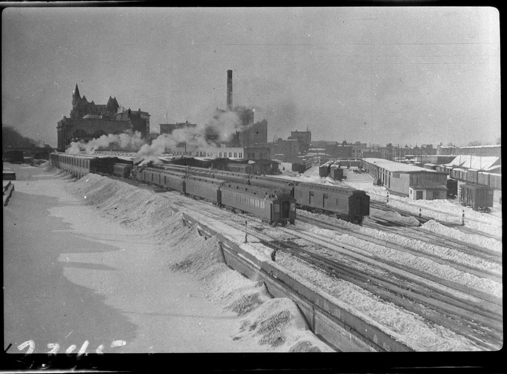
Approach tracks and Bush trainshed, Ottawa Union Station. A wintery scene, with a frozen Rideau Canal on the left. The yards at right are now occupied by the Rideau Centre, Convention Centre, and Department of Defense Headquarters (Library and Archives Canada)
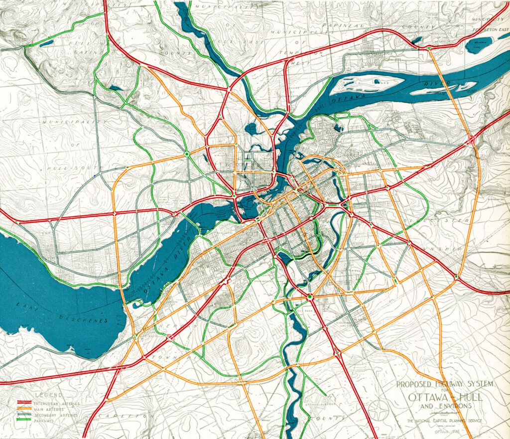
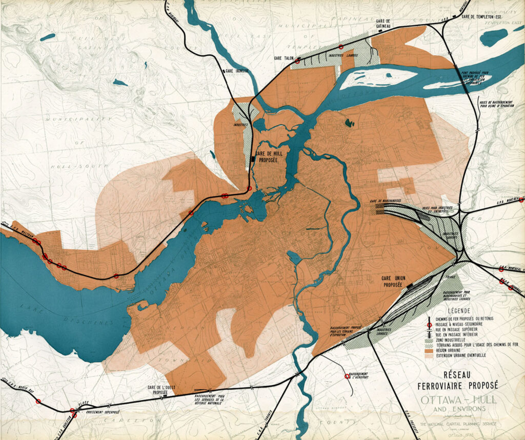
In the 1940s, the federal government led by Liberal prime minister William Lyon Mackenzie King wanted to beautify the nation’s capital region and address traffic congestion. Ottawa — and the federal government — was rapidly growing, while political leaders wanted a cityscape that matched the ambitions of an expanding nation. French urban planner Jacques Gréber was commissioned to plan the region’s future; Gréber’s recommendations, released in 1950, were ambitious and transformative. (You can read the entire report here.)
The Gréber Plan — formally titled “Plan for the National Capital” — called for new highways, the abandonment of Ottawa’s streetcars (which were seen as antiquated with unsightly overhead wires), and the removal of all railway infrastructure within the City of Ottawa. The old CN and CPR lines would make way for new roads, including a four-lane arterial along the east side of the Rideau Canal, leading to a new road bridge replacing the Alexandra. A new railway bypass along the periphery of the city would replace all urban trackage, with a proposed new Union Station site in Gloucester Township, south of Walkley Road. Most industrial uses — including the historic paper mills along the Ottawa River — would be moved to the new railway line.
Proposed highway system for Ottawa-Hull and environs, from Gréber’s reportProposed Railway system: Ottawa Hull and environs from Gréber’s report
Though the plan was not fully implemented, it did set the stage for much of the urban planning and infrastructure changes during Ottawa’s next fifty years. The railway bypass was constructed between Bell’s Corners in the west and Ramsayville in the east, with the old Grand Trunk tracks through the city replaced with The Queensway, now part of Highway 417. New parkways lined the rivers and canals. Two new multilane traffic bridges crossed the Ottawa River (though the Alexandra Bridge was maintained for traffic and pedestrians) and Albert and Slater Streets were made one-way, with a new bridge over the Rideau Canal (the Mackenzie King Bridge) linking them to the east. A large Greenbelt encompassed the city region, intended to direct growth while preserving natural areas.
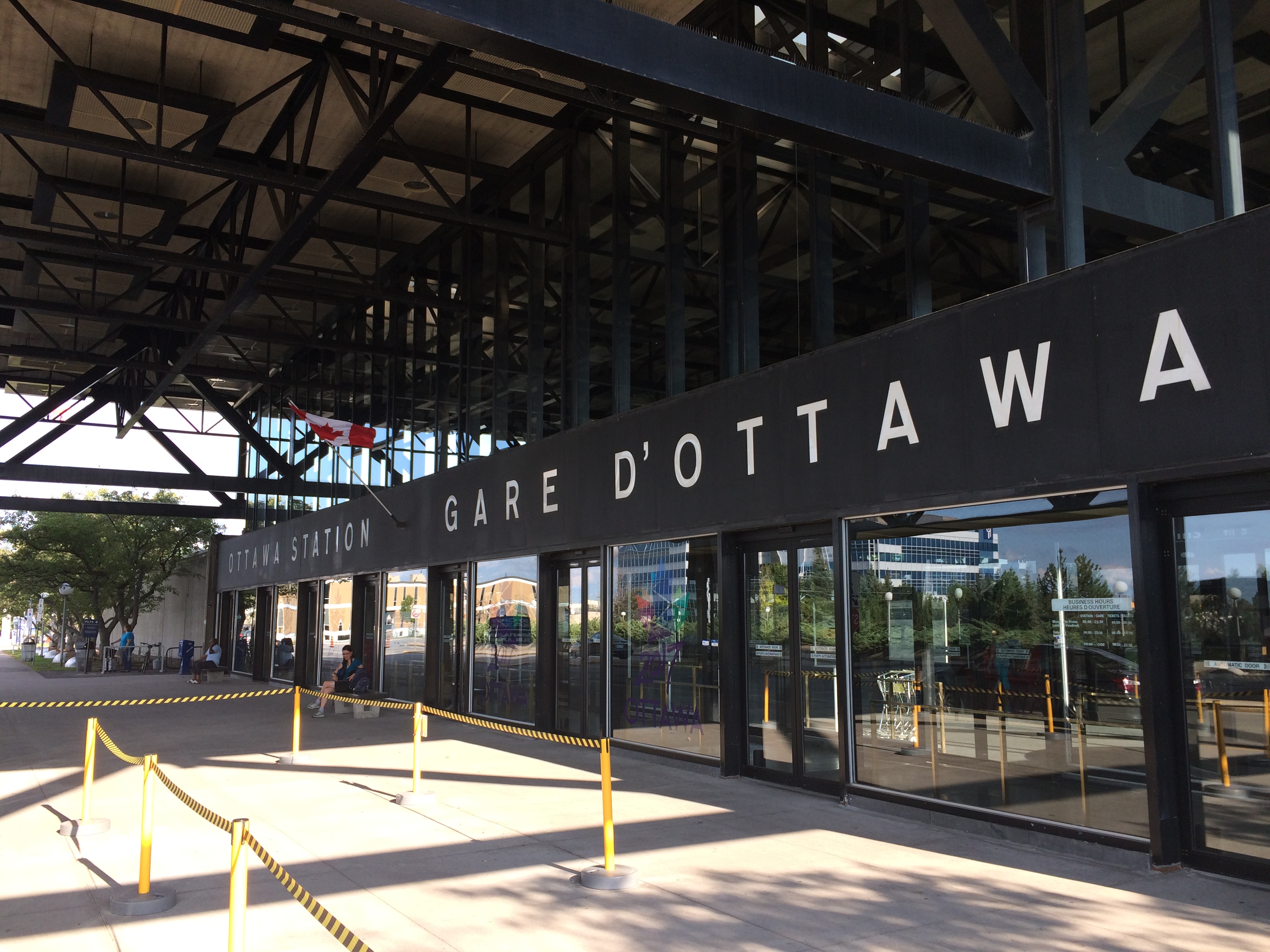
Fortunately, the passenger station was relocated to a point much closer to the city centre than the Gréber Plan envisioned: the old CN and CP tracks along the Rideau River south of the city centre were kept in place but rerouted to serve a new modernist station that opened in July 1966. The new Ottawa Station, designed by John C. Parkin, is one-of-kind. The architecture invokes an airport terminal, with large, sheltered driveways and an airy open lobby/concourse, and was the last grand railway station built in North America. In 1966-1967, there were still two daily transcontinental trains departing from Ottawa Station, along with multiple trains to Toronto and Montreal, including a Toronto-Ottawa night train. Today, there are just eight trains to Toronto and five trains to Montréal.
Ottawa Station, which opened July 31, 1966
Soon after the new station opened, the tracks and ancillary buildings around Union Station were removed, making way for Colonel By Drive, the Rideau Centre shopping mall, a new convention centre, and headquarters for the Department of Defense. The station building itself survived, however, first becoming a temporary museum space during the 1967 Centennial celebrations, then a government conference centre, mostly closed off to the public.
The temporary Senate Chambers in the former train concourse at Ottawa Union Station
Right now, the grand building is the temporary home of Canada’s Senate, and is again accessible to the public, via a free tour. The renovations to the building are very sympathetic to the built heritage. As reconstruction of Centre Block, the regular home of both Houses of Parliament, is still five years away from completion, there’s still lots of time to take the tour.
Awaiting Alto
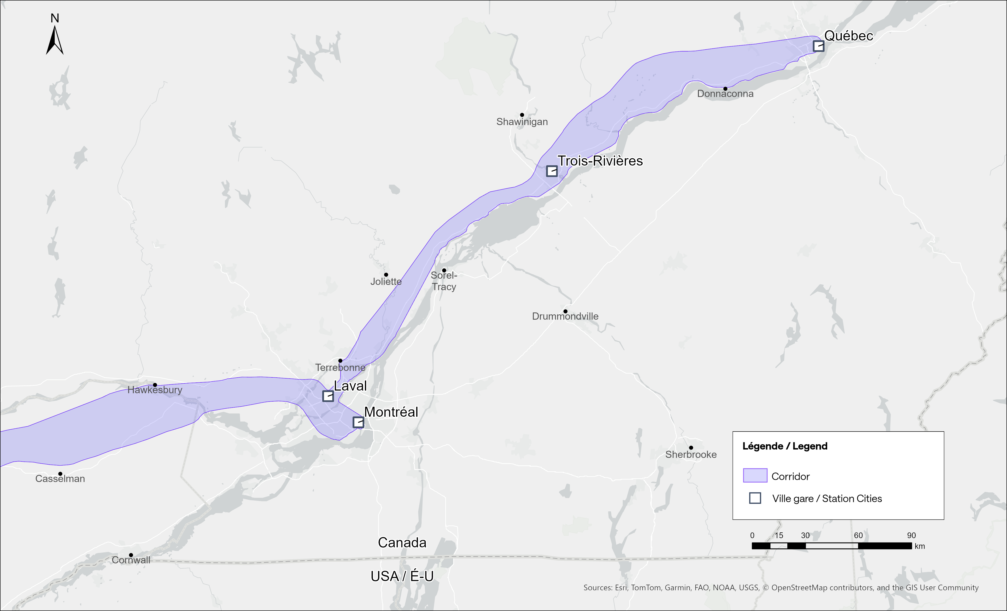
The Alto high speed rail line project, now in the planning stage, will connect Québec, Montréal, Ottawa, and Toronto, with a total of seven stations (the other three are planned in Trois-Rivières, Laval, and Peterborough). The first segment, with the start of construction set for 2029, will link Montréal, Laval, and Ottawa. Consultations on the specific route and station locations are underway, with the broad corridors noted in maps available on the Alto website.
Map of potential routings for the Alto high speed line in OntarioMap of the planned routing for the Alto high speed line in Quebec
The maps clearly show a route between Ottawa and Montréal that will pass through Prescott & Russell Counties, roughly following an abandoned CPR corridor until about Hawkesbury, at which point it would cross into Quebec (following an older abandoned CNoR route) to Laval, then continue south into central Montréal, though not necessarily the existing Central Station (this would likely require a new tunnel under Mount Royal). The Montréal station appears to be a terminal for trains coming from Ottawa and from Trois-Rivières and Québec, much like the existing VIA Central Station.
Alto’s next phase towards Toronto could follow one of two broad routes between Ottawa and Peterborough, either just north of Highway 7, through the Canadian Shield, or a southerly alignment through the Rideau Lakes region and then through South Frontenac and passing near Stirling and Campbellford. All planned routes would require passing through Ottawa entirely on the Ontario side of the Ottawa River, making a through station particularly likely, especially for the critical Toronto-Montréal market.
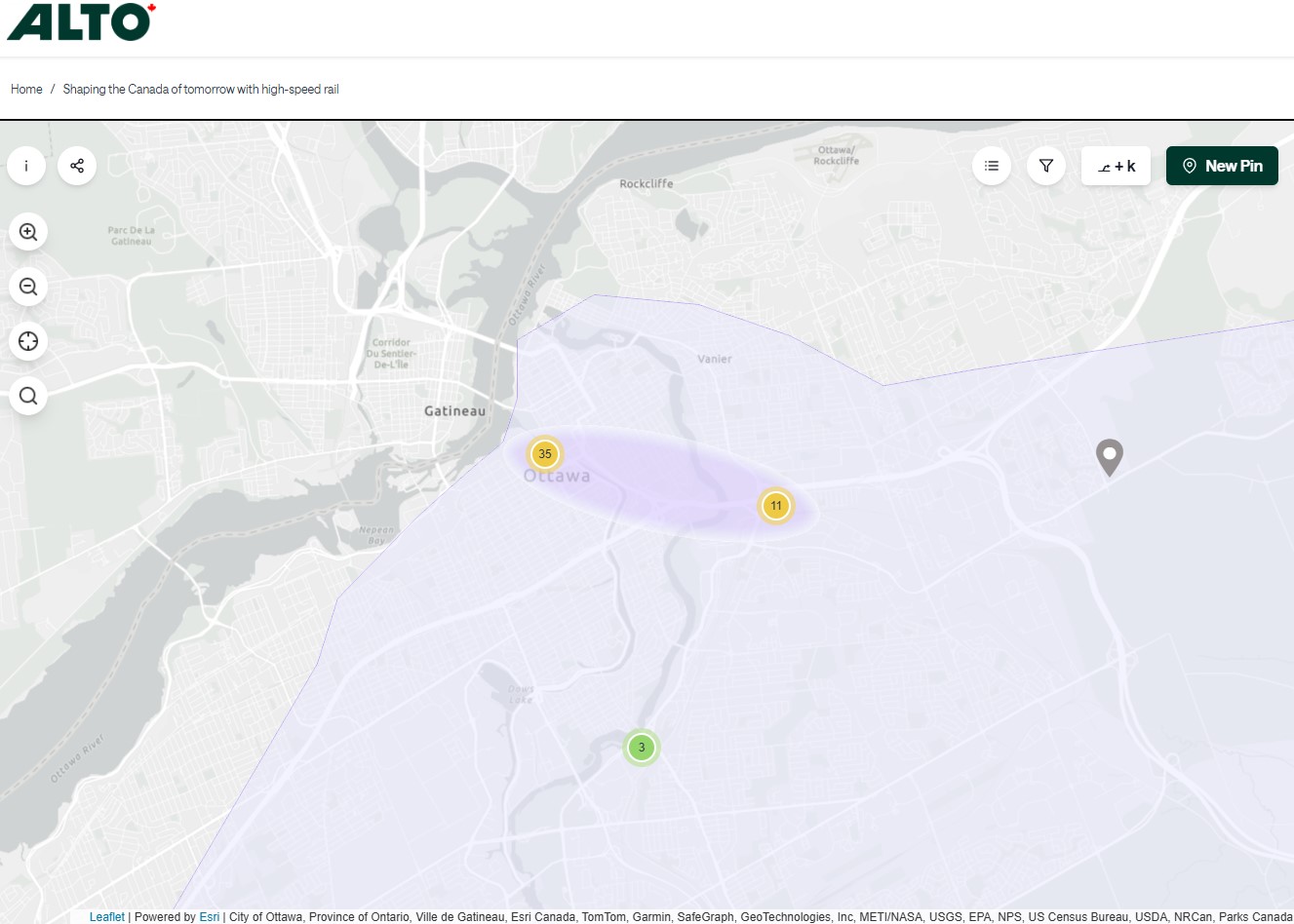
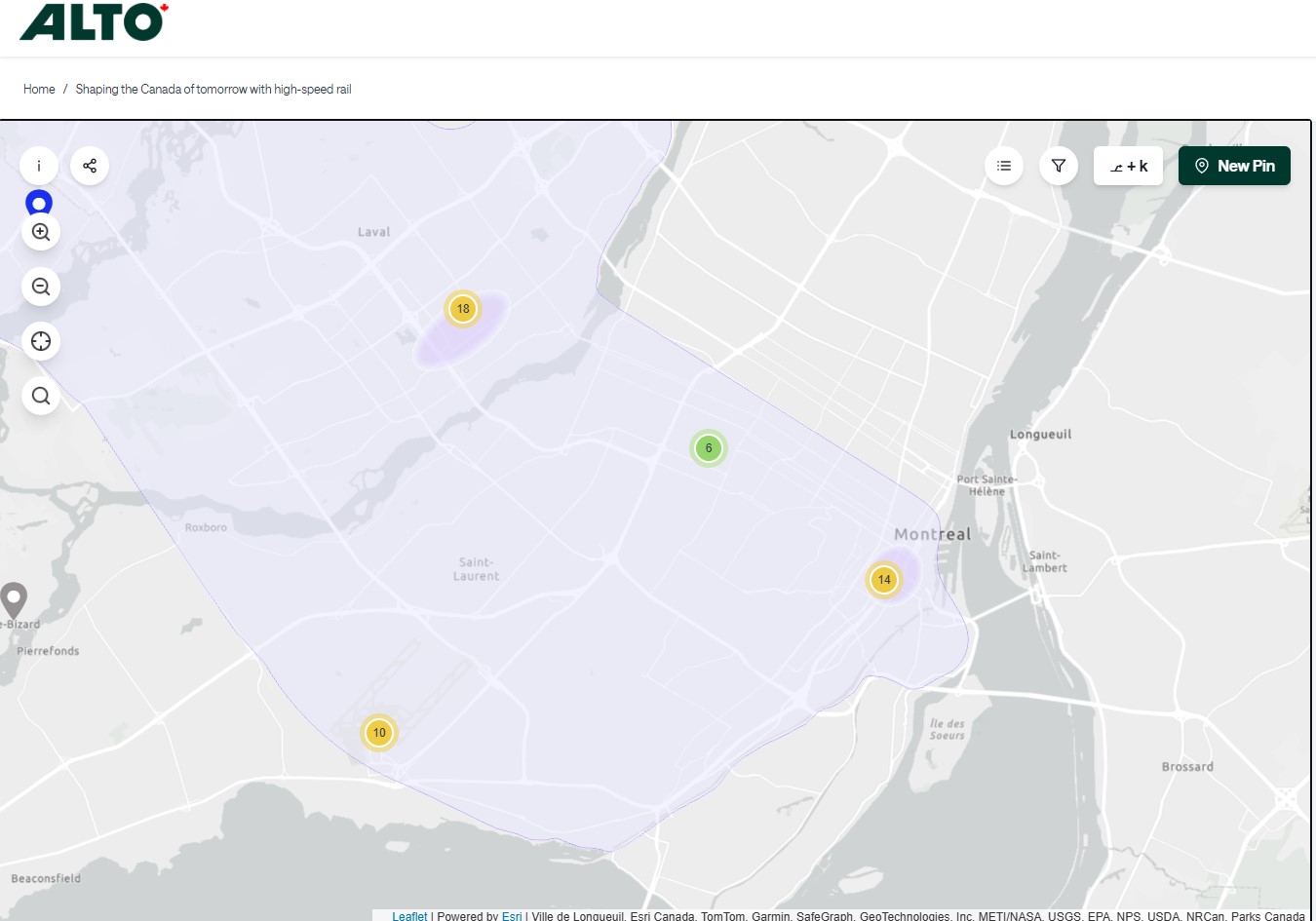
On the detailed consultation map, highlighted areas show where the seven station locations are being considered.
The map for Ottawa shows possible station locations in an area including the current VIA station and the old Union StationThe Montréaland Laval station locations under consideration. The Montréal station area highlighted includes the locations of Central and Lucien L’Allier Stations.The Montréal station for Alto is clearly intended to be a terminal.
The idea of a downtown Ottawa Station for the new high speed rail corridor is certainly enticing. It would breathe new life into a 114-year-old landmark, provide a very convenient spot for Ottawa politicians, public servants, business travelers, tourists, and students attending nearby University of Ottawa. Rideau O-Train Station is less than two blocks away. However, it would require a new tunnel and/or elevated structure to reach the station from the rail corridors to the south. Furthermore, Centre Block would have to reopen on schedule so the Senate can move back before construction can start on refurbishing the station for passenger service.
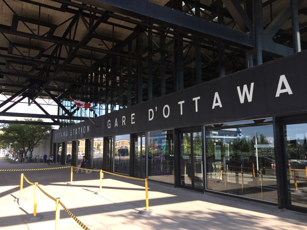
The 1966 Ottawa VIA Station, on the other hand, has its own advantages. There is plenty of room to build new high speed train platforms, which should provide level boarding for efficient passenger movement. There is also room for parking, passenger pick-up and drop-off, as well as easy access to the highway, unlike Union Station. With the closure of the Ottawa bus station, the VIA Rail Station has become a multimodal hub, with Ontario Northland, Flixbus, and Orleans Express all using the station’s driveway, along with a KLM/Air France shuttle to Dorval Airport. There is also a dedicated O-Train LRT station on-site, though it could be better integrated with the station building.
Perhaps most importantly, the existing VIA station can help ensure the existing Corridor service remains integral, as passengers from Kingston, Belleville, and elsewhere on Lake Ontario and the St. Lawrence River will not be served by Alto; neither would Casselman, Alexandria and Dorval. That the station is a through-line, and not a stub-end terminal, will also ensure that the crucial Toronto-Montréal market will see minimal delays from back-tracking and reversing at a downtown terminal. Though there are instances of high-speed trains reversing directions at major hubs — Trenitalia’s Frecciarossa mainline between Milan and Salerno turns back at Roma Termini and at Napoli Centrale — this is an uncommon arrangement.
All the planned Alto high speed rail stations will have to be easily accessible and close to the downtown cores of the cities it serves. At this point in the planning process, this looks like it will be the case at all three big city stations. But it will need more than walk-up traffic like downtown office workers and tourists; it will be most successful as part of a complete network of local, regional and intercity transport, including the conventional VIA rail system. With specific improvements, including new platforms and better O-Train station integration, the modern yet historic 1966 Ottawa Station is well suited for all of these needs.
Over the last six years, Greyhound Canada disappeared after years of decline, the COVID-19 pandemic hit with travel restricted, the Ontario provincial government set up one-time funding for intercommunity transport links while deregulating the intercity coach industry, and many municipalities dipped their toes into providing rural transit services.
At the end of 2025, there was some good news to note — several rail transit lines opened in Toronto, Montreal, Ottawa, and Edmonton, while a few new rural services opened in Eastern Ontario. Unfortunately, there were also some major losses in Ontario, particularly in Grey County, Oxford County, Napanee-Deseronto, and the impending cancellation of a major route in Essex County. Unlike in Ontario, however, rural transport links remain stable in Quebec and British Columbia.
Stable funding is essential to keep these intercommunity and intercity links alive, particularly where private operators have not filled a need. For example, Flixbus recently cut back their once-a-day route from Toronto to the Lake Huron coast and will not serve rapidly-growing Saugeen Shores during the colder months. That part of Ontario is left only with a three-days-a-week TOK coach despite potential demand. A well-funded regional transport service coordinated by Grey, Bruce, and other adjacent counties could address this, but there needs to be political will to ensure stable and predictable service needed to grow ridership over the long term.
I just completed a round of edits to my intercity map, noting changes to routes, service levels, and in some cases, stop locations. A few new scheduled air shuttles in Atlantic Canada and Manitoba are included; these types of services are only mapped if they also provide non-airport service or at least connect to urban transport.
There are also more grey lines. Starting with edits in mid 2024, I have chosen to grey out abandoned routes, rather than just eliminating them. It is well worth noting where transport links have disappeared, and where replacement service might be worth planning.
Hopefully 2026 will see better service than the end of 2025.
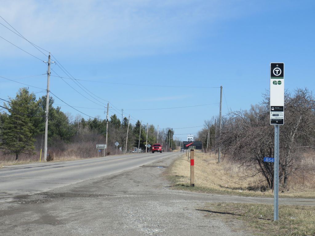
New GO Transit bus stop on Chiefswood Road at Six Nations
As we enter Spring 2025, there are a few significant changes in Ontario’s intercity transportation services. A new daily GO Transit route will now connect Six Nations and the Mississaugas of the Credit First Nation with Brantford, Hamilton, and Greater Toronto. A new seasonal Waterloo-Burlington weekend express could foreshadow more direct service between Kitchener/Waterloo and Hamilton in the future. Flixbus moved its Ottawa terminal stop to the VIA Rail station, joining Ontario Northland and Orleans Express.
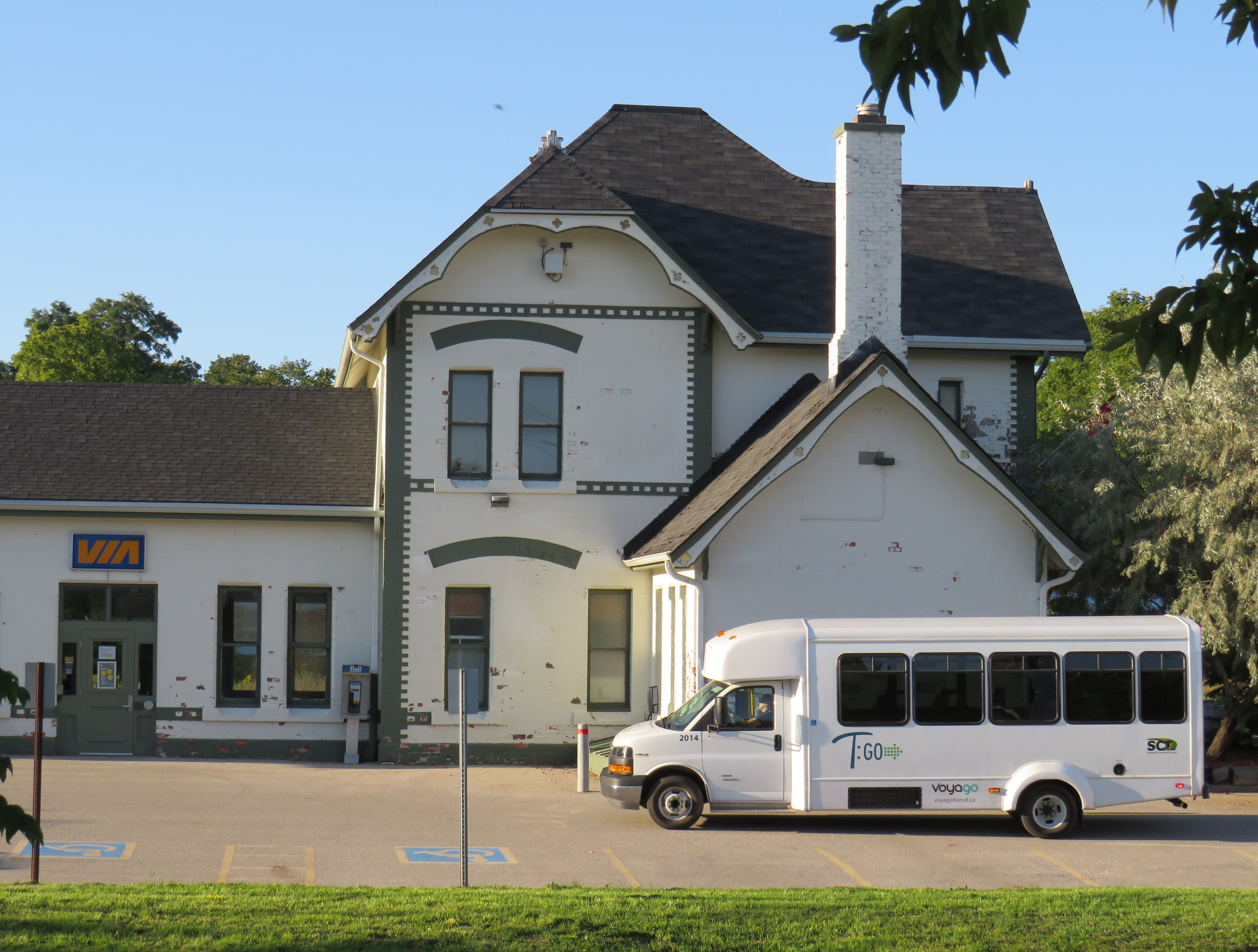
However, there are also some cuts, triggered by the end of the Ontario Intercommunity Transportation Grants. Grey County will terminate all GTR services with the exception of Route 1 between Dundalk, Shelburne, and Orangeville. T:GO is ending its intercommunity services outside of Tillsonburg, including routes that connect with Woodstock and London. PC Connect is cutting its rural route that serves places like Mitchell and Milverton (though routes connecting Listowel, Stratford, and St. Marys to Kitchener/Waterloo and London will continue).
Unfortunately, T:GO will end all intercommunity bus routes outside of Tillsonburg, including the link to Woodstock
Recently, I provided my expertise mapping Canada’s intercity transit links to Transport Canada, which allowed me to enhance and update the interactive map. I am also working with Transport Action Canada to support their efforts advocating improved intercity transport across the country.
As always, please contact me with feedback, corrections, or updates. It is a challenge continually maintaining a Canada-wide map given how frequently things change.
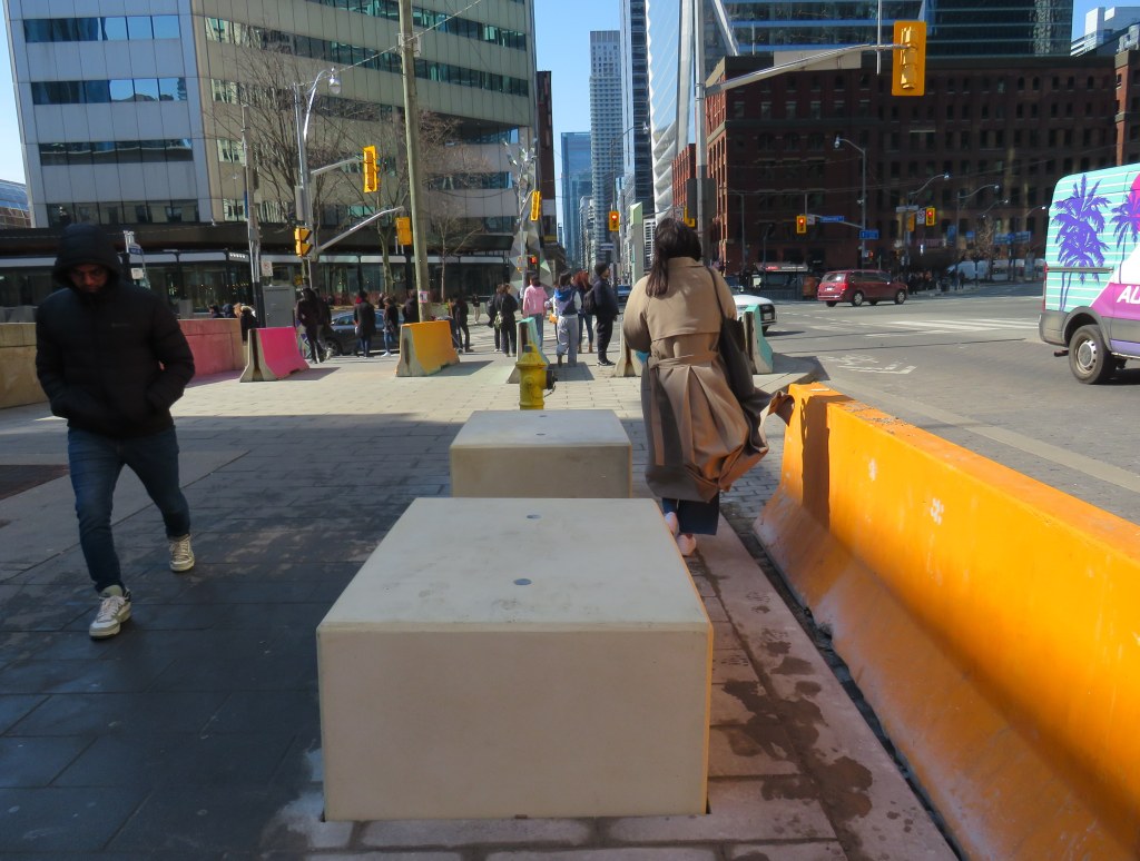
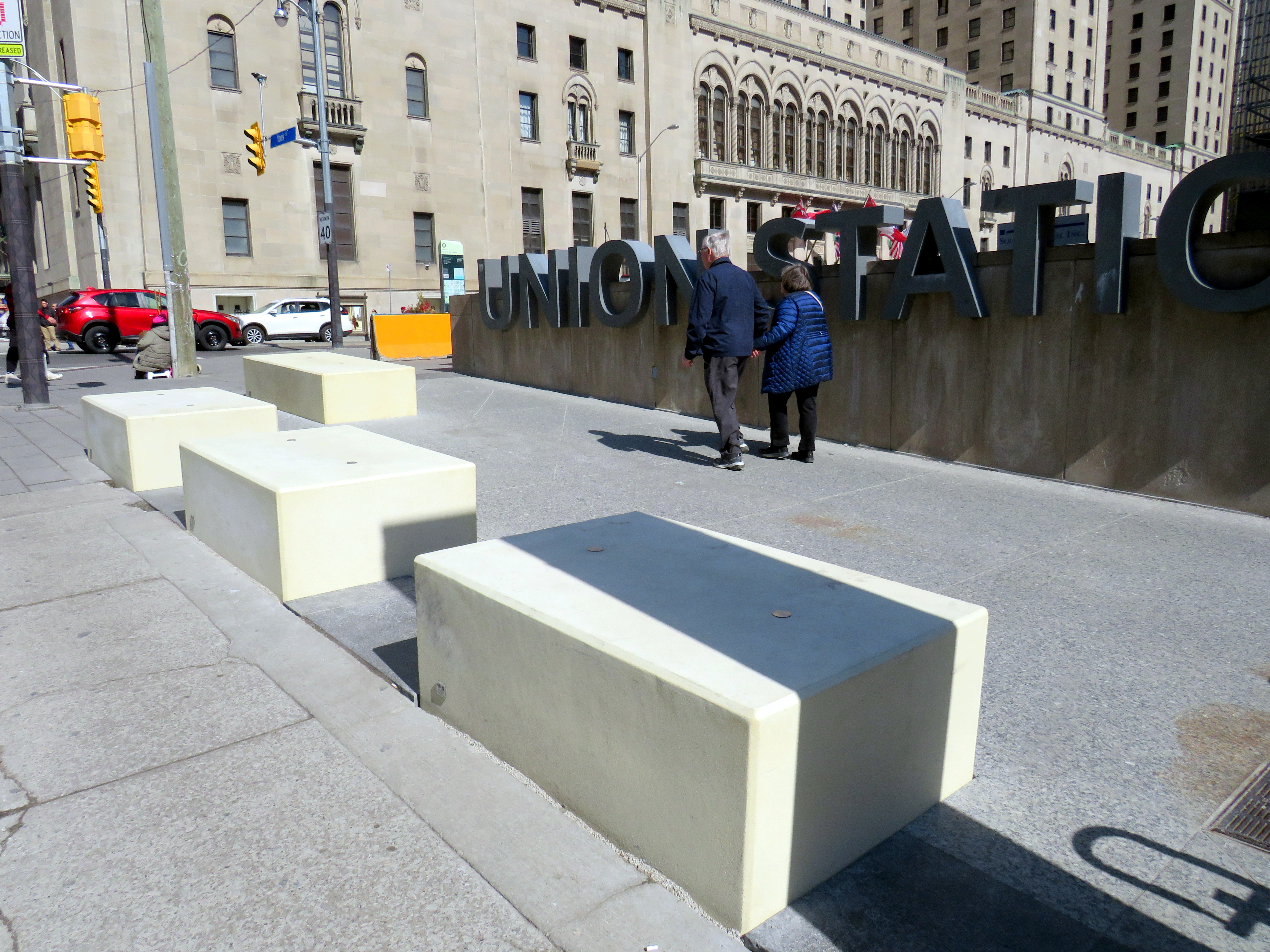
New blocks installed in front of Union Station at Front and York Streets
When I learned that Union Station was finally getting permanent bollards to replace the haphazardly-placed Jersey barriers that have sat in front of the transport hub since 2018, I was relieved. I wrote about these barriers several times on this website, criticizing their appearance and their placement, blocking the way for the thousands of people who cross Front Street every day. But when I went to see them in person, after seeing criticism online, I was dismayed.
The new permanent barriers might even be worse than the temporary obstructions they are meant to replace.
The Jersey barriers were hastily placed after a tragic attack on Yonge Street in North York, where a man intentionally drove a rented van on to the sidewalk, killing ten pedestrians and injuring and traumatizing many more.
Vehicular assaults on crowds of pedestrians are a major concern; tactics used at mass gatherings — such as the winter light show and New Years Eve events at Nathan Phillips Square and major concerts and playoff games at Skydome and Scotiabank Arena — now include blocking closed streets with heavy vehicles such as snow plows, dump trucks, and city buses. However, Union Station is the only place in the city where officials have decided that new permanent barriers were necessary.
Union Station is one of the busiest pedestrian areas in the city
The new permanent barriers are not the sturdy, yet narrow, bollards that are used elsewhere. Instead, they are large, undecorated concrete blocks anchored into the ground and are knee-high. The plain concrete colour does not match the stone sidewalks or plaza. They are placed very close together, impeding access for those using large carts, strollers, or wheeled mobility devices. Despite all the money spent renovating Union Station, these blocks look cheap.
Concrete blocks at the corner of York and Front Street at Union Station
The total cost of installing the “Custom Anti-Terror Concrete Barriers,” as the city described the bid, was $2,438,238, including HST. The lowest bid, by South Central Inc., came over a $1 million cheaper than the other two bids. It is worth noting that there are no public documents that describe the city’s specifications for the contract, nor was there any public consultation before the city solicited bids.
The result? An esthetic failure and an accessibility challenge.
Video showing pedestrians going around the concrete blocks in front of Union Station
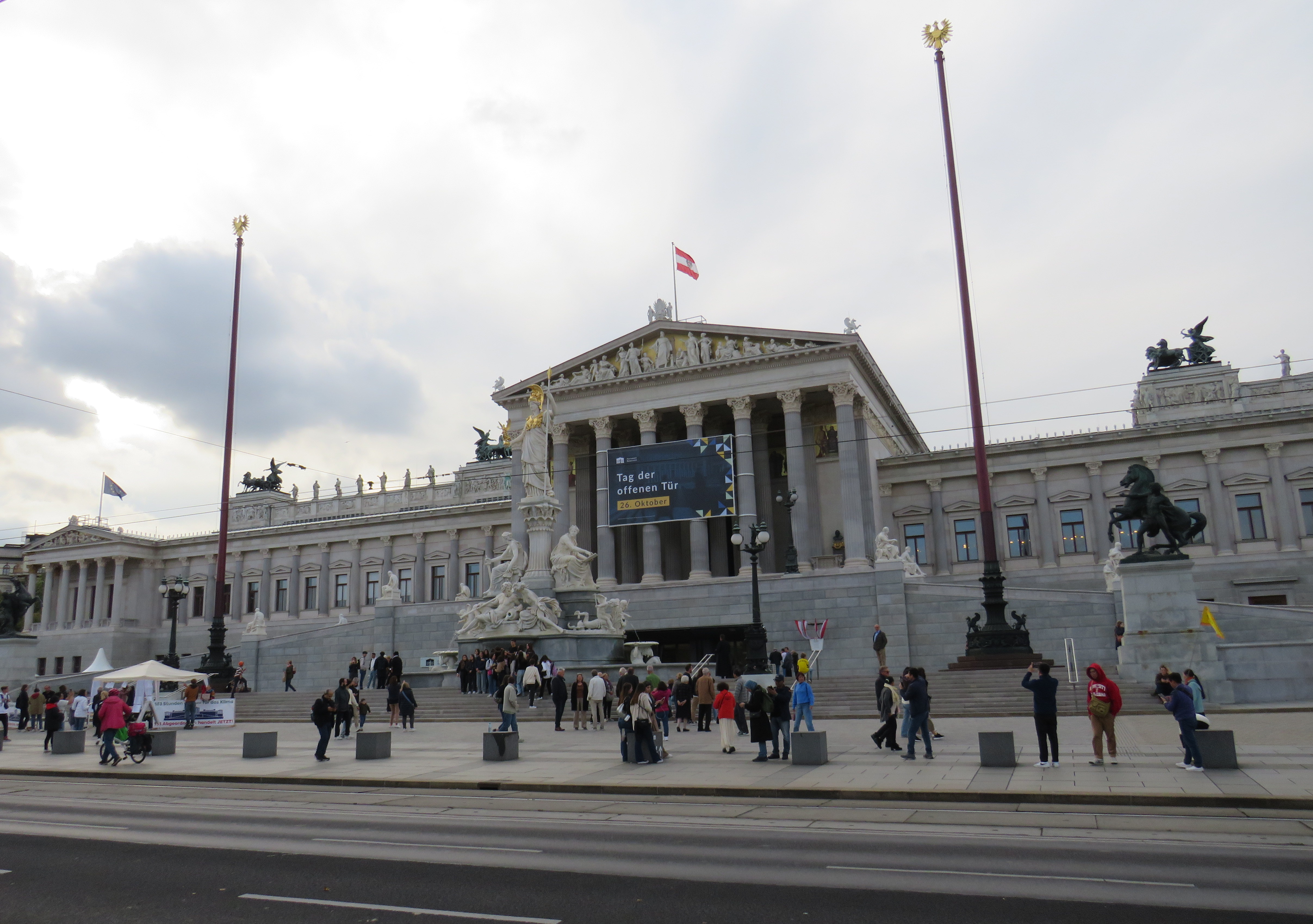
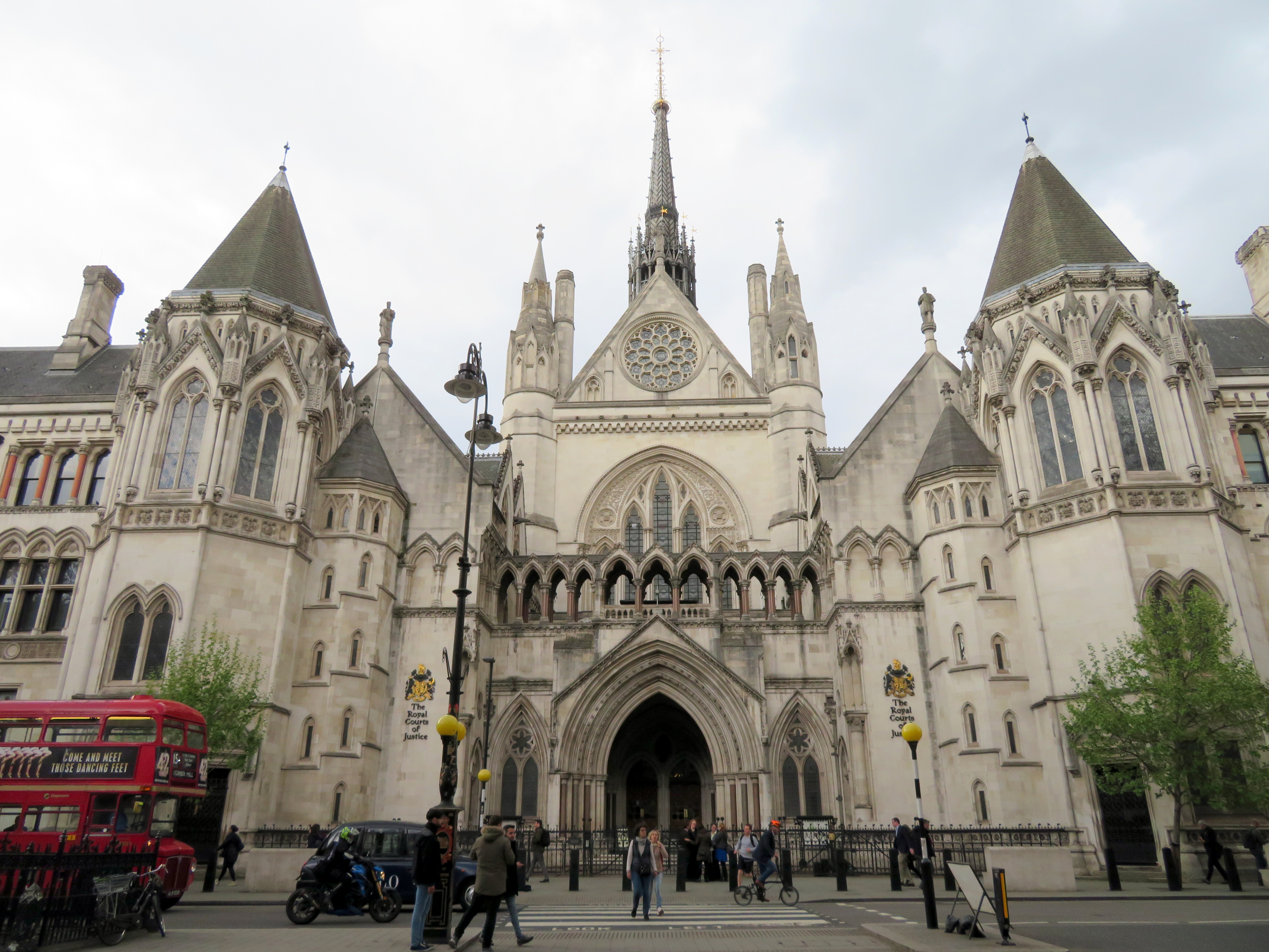
I cannot understand the city’s decision to go with these blocks where more elegant and pedestrian-friendly alternatives are typically used elsewhere. For example, the Austrian Parliament Building in Vienna, which faces the famous and busy Ringstrasse, is protected by smaller concrete bollards, which are also more widely separated, making it much more pleasant for pedestrians to get by. In Great Britain, metal bollards are common on busy commercial streets and in front of important buildings, but they are easy for pedestrians to pass, and generally blend in.
Thick concrete bollards in front of the Austrian Parliament Building, 2023Metal bollards in front of the Royal Courts of Justice in London
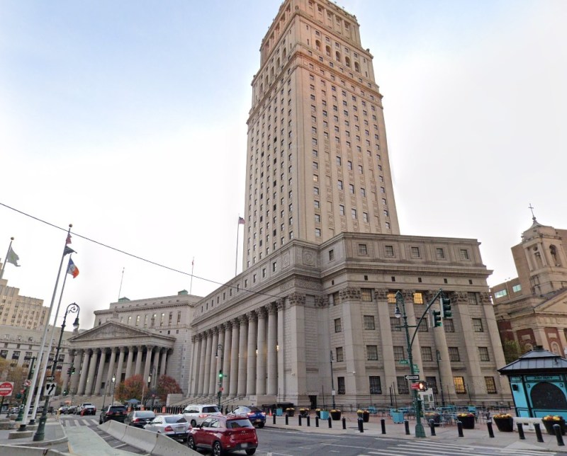
In the United States, government buildings are also protected by heavy anti-vehicular barricades (especially since the 1995 Oklahoma City bombing), but they are generally more permeable for pedestrians.
Metal bollards protect the federal courthouse in Downtown Manhattan (Google Streetview)
It is also worth noting that other popular pedestrian areas, such as the Yonge-Dundas intersection, are not protected from a potential vehicular attack — or an unintentional collision. It is beyond comprehension why the city only focused on protecting one pedestrian area, using such a poorly thought-out design. Toronto can — and should — do better.
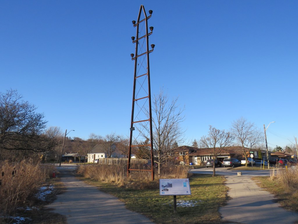
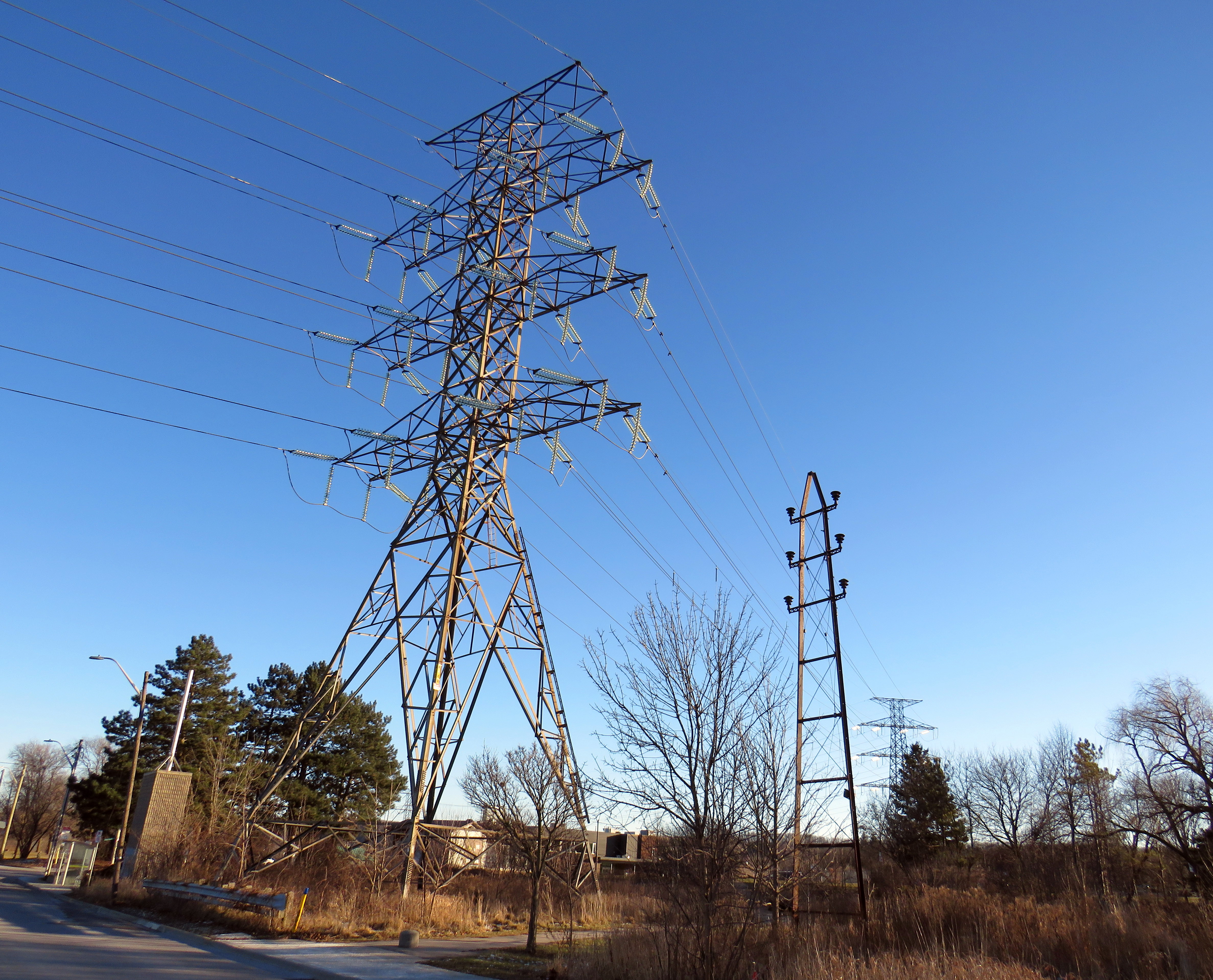
A modern electric tower looms over an early hydro pole
On the edge of a quiet postwar neighbourhood in Hamilton, Ontario, there is a remarkable remnant of a time gone by, preserved in situ, accompanied by an interpretive plaque. A small steel hydro-electric transmission tower stands in a park, once part of a pioneering 43-kilometre corridor that connected Hamilton with a new hydro-electric generating station at DeCew Falls, near St. Catharines. Next to the old pylon stands a much taller tower carrying electric lines along the same corridor.
Looking south, with the old tower facing the Rosedale neighbourhood
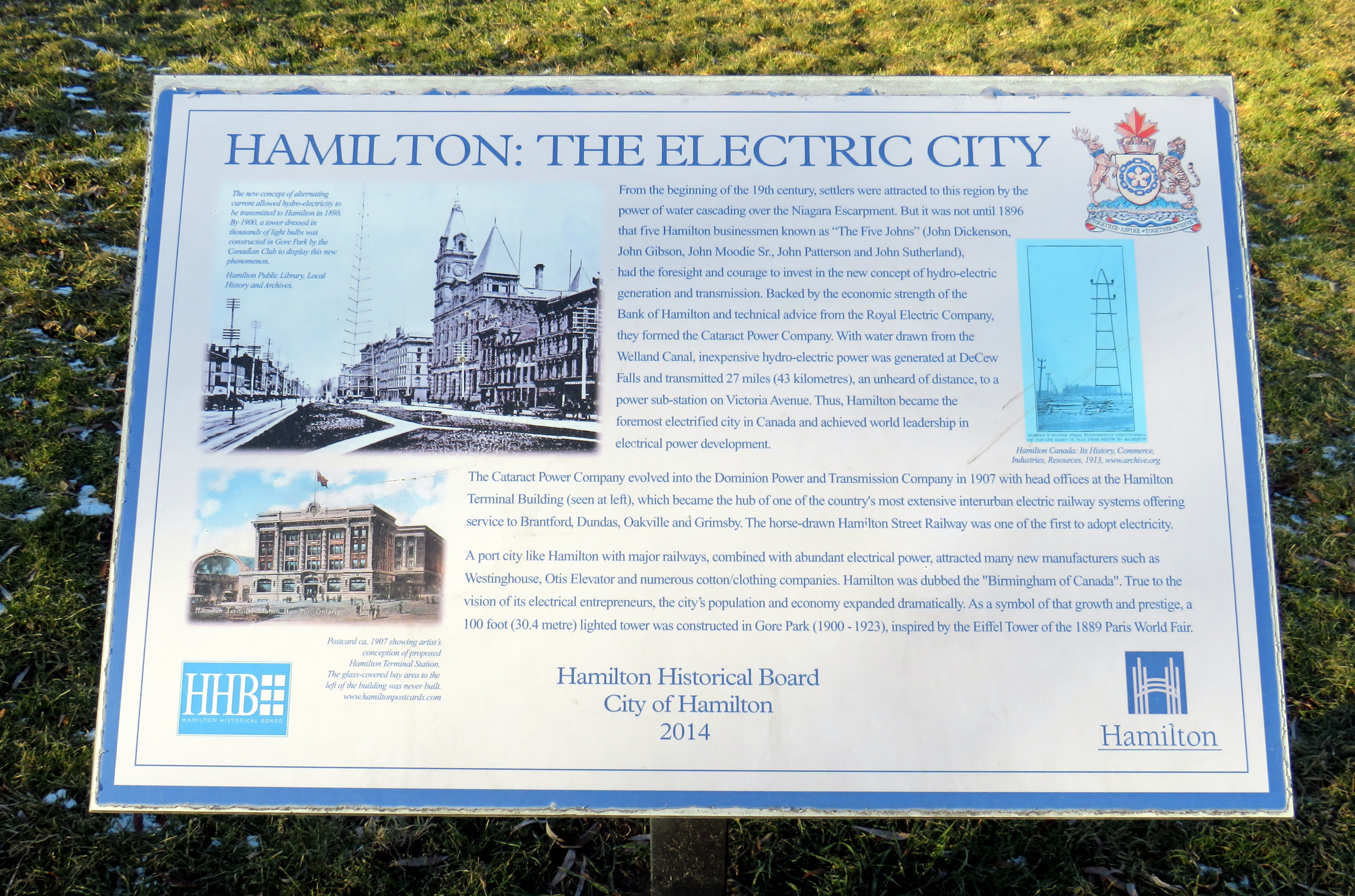
Both the DeCew Falls plant and the transmission corridor were constructed by the Cataract Power Company, an organization founded by five Hamilton businessmen, who all had the first name John. “The Five Johns” took control of the city’s power generation and distribution, electric lighting, as well as the Hamilton Street Railway (HSR) and electric interurban railways (known as radials) to nearby cities and towns including Dundas, Oakville, Brantford, and Beamsville. The HSR began electrified streetcar service on June 29, 1892, several months before the first electric streetcar operated in Toronto.
The tower was erected by the Dominion Power Company (the successor company that absorbed the Cataract) in 1913, as part of an upgrade of the corridor between Hamilton and DeCew Falls, and it is the only one of its vintage to survive. Beside the old tower, a modern hydro-electric corridor follows the same route south, up the Niagara Escarpment.
Access to cheap, reliable hydro-electric power was one reason why Hamilton was able to thrive as a major industrial centre, attracting steel producers, tire and auto manufacturers, textile mills, and electrical equipment suppliers. That, along with excellent water, rail, and road access helped to make the “Golden Horseshoe” at the western end of Lake Ontario shine.
Plaque installed by the Hamilton Historical Board in 2014 titled Hamilton: The Electric City
Eventually the hydro dam, the transmission corridor, the HSR, and the radials were taken over by the Hydro-Electric Power Commission of Ontario, which consolidated the many private power companies throughout the province and putting them under public control. Adam Beck, who headed the commission, was also an advocate for interurban railways, so control of the HSR and the radials was a natural fit. Unfortunately, Ontario’s radial railways were never fully consolidated, and most disappeared by the early 1930s. Hydro, however, kept control of the HSR until 1946, when it was sold to Canada Coach Lines, a Hamilton-based intercity carrier whose routes followed several of the old radial lines. Under private CCL ownership, the last streetcar lines were replaced with diesel and electric trolley buses by 1951.
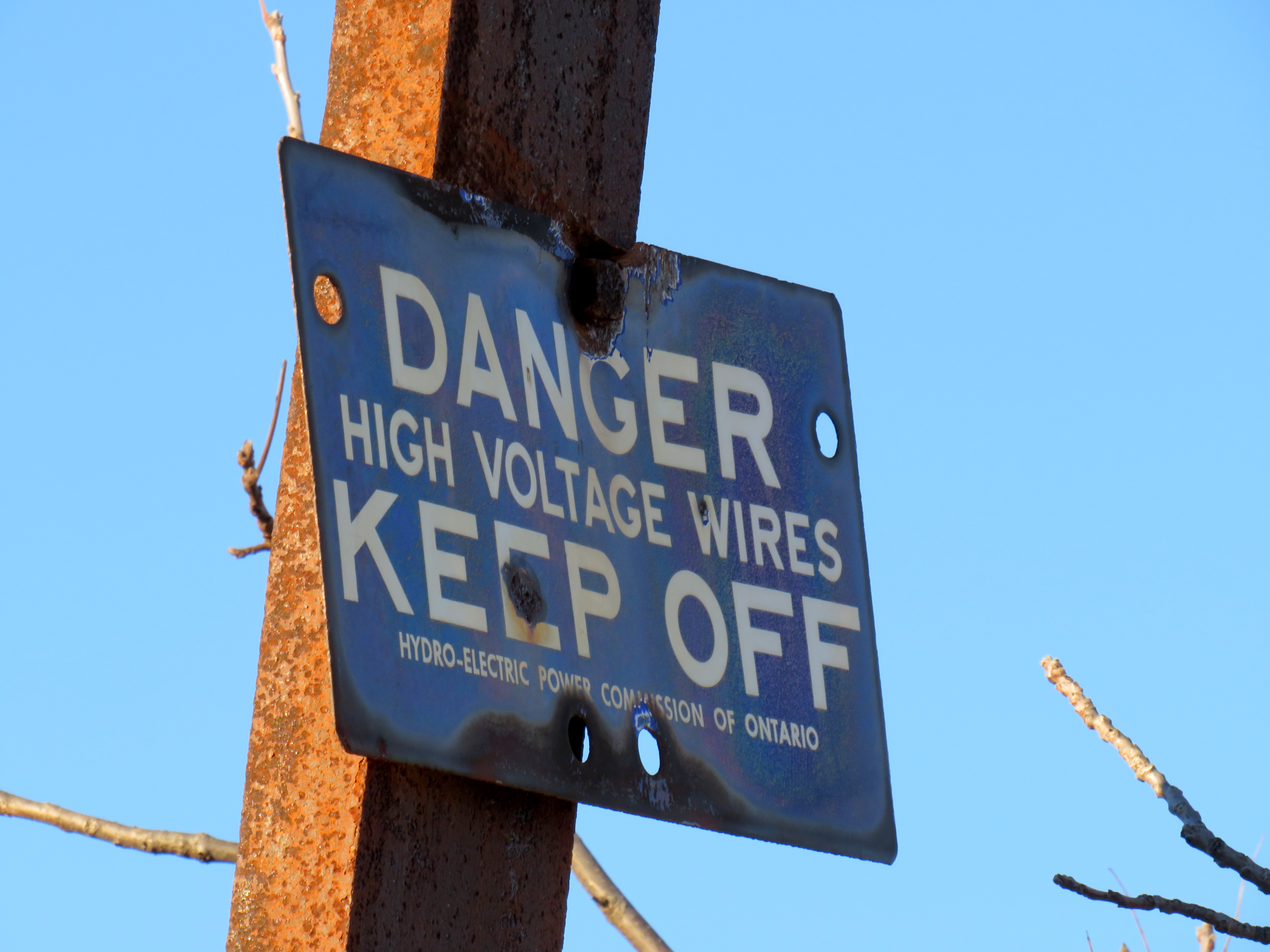
The “danger – high voltage wires” sign on the old tower bears the Hydro-Electric Power Commission of Ontario name. HPEC, later known as Ontario Hydro, took over the corridor from the private Dominion Power Company.
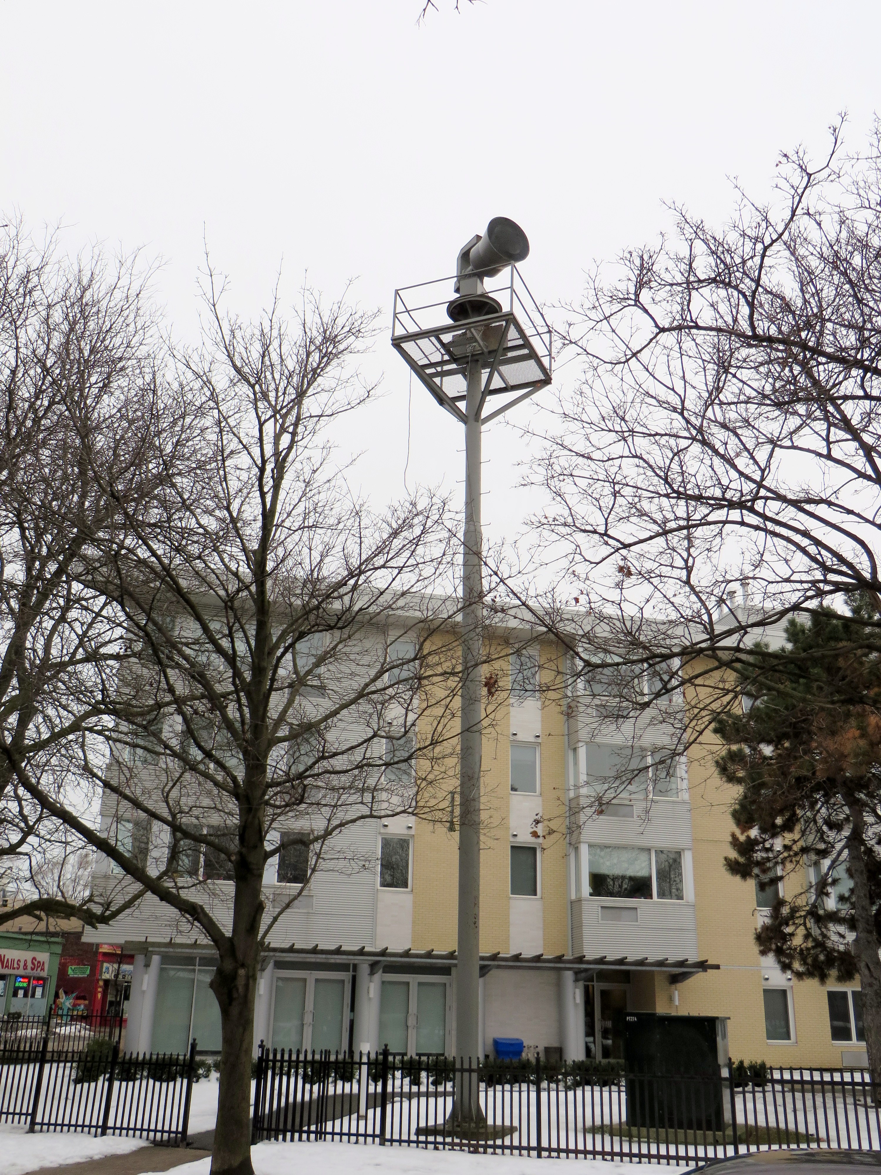
Heritage preservation need not be concerned only with major landmarks and grand buildings. Sometimes the seemingly mundane details matter too, and tell us about the history of our built environment. In Toronto, at Dundas Street West and Shaw Street, an old air raid siren still stands at the top of a long metal tower. These sirens were common place from the 1950s to 1980s, but they were mostly taken down as they became redundant due to modern missile technology (rendering evacuation and “duck and cover” measures useless) and the eventual end of the Cold War.
Today, the remaining siren tower is also a reminder of those times.
Disused air raid siren still stands at Dundas and Shaw
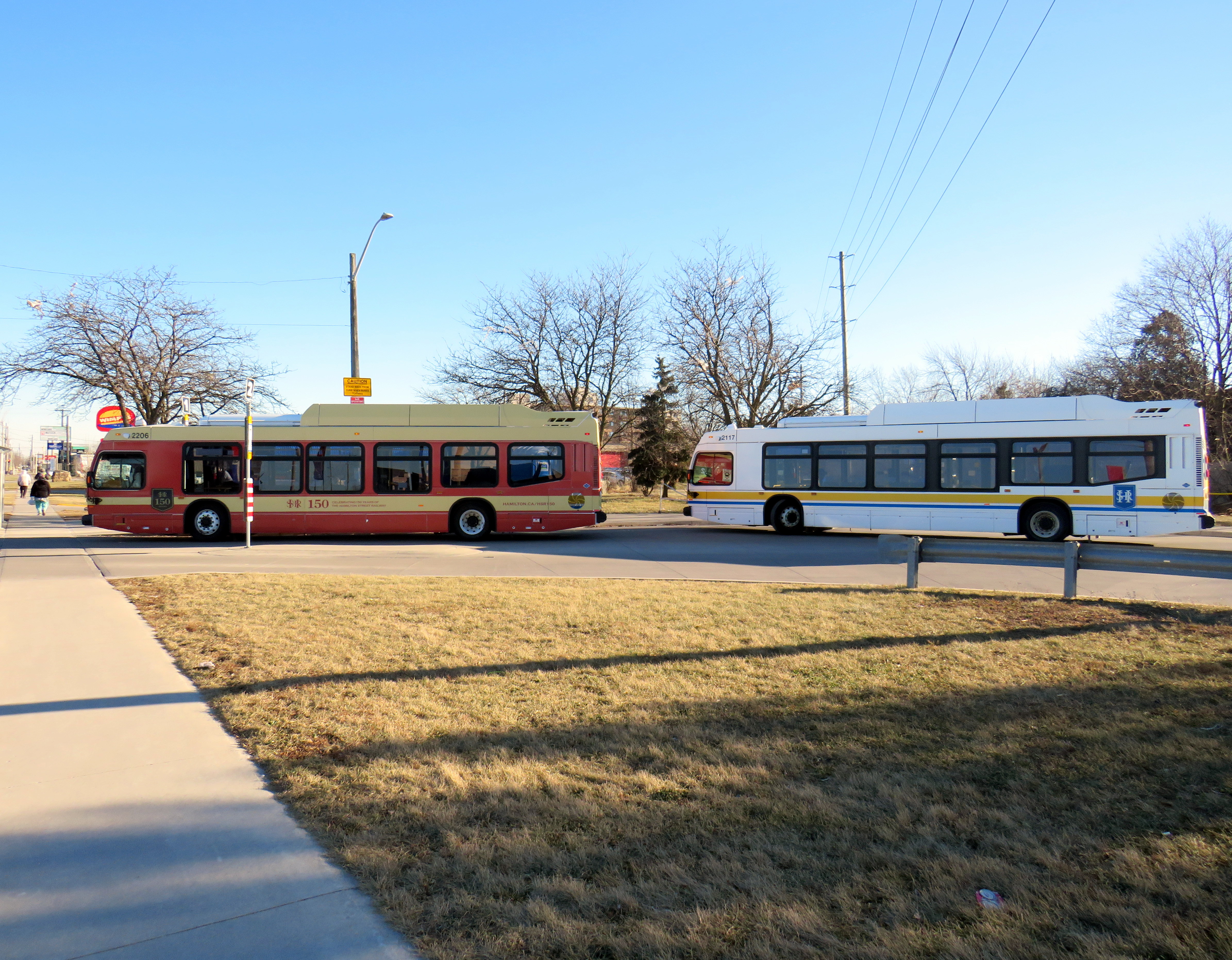
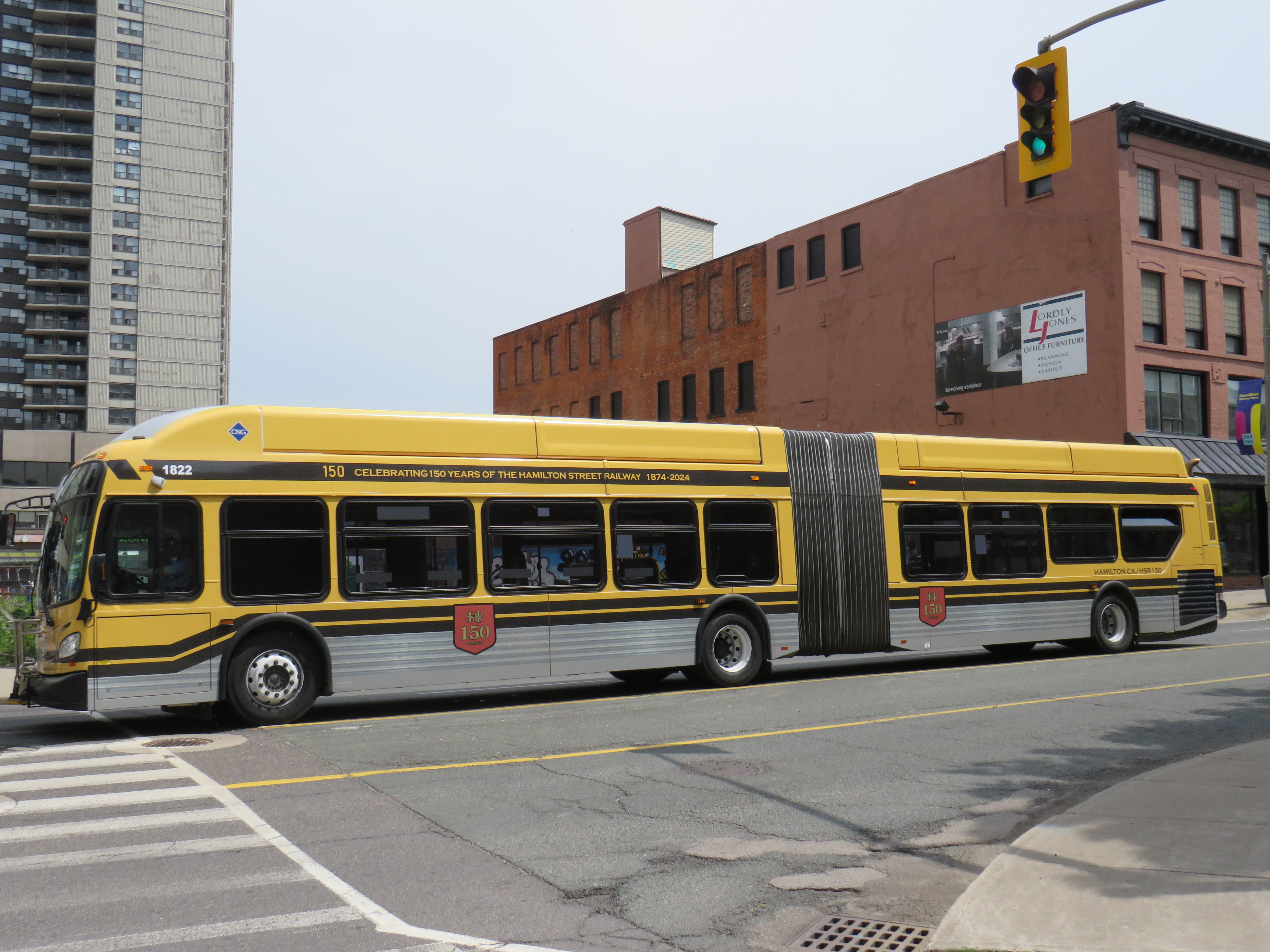
One more thing that the City of Hamilton has done in the last year is paint two of its buses in retro liveries, celebrating the 150th year of the Hamilton Street Railway Company. Though the HSR hasn’t actually operated streetcars since 1951 (and abandoned trolleybus service in 1992), the name persists through multiple ownership changes, even after municipal ownership starting in 1960.
One bus sports the 1950s-1960s-era colour scheme of burnt red and cream, while a second bus has the classic yellow and black “Ti-Cats” look used in the 1970s and 1980s. Though modern buses still have a prominent yellow stripe and the long-running interlaced HSR letters-in-a-shield logo, there’s nothing quite as says “Hamilton” quite like classic yellow and black scheme.
Two modern Nova low-floor buses layover at the end of the Barton Street route, with one in the 1950s-era red-and cream colours, and the other in the current colour schemeA New Flyer articulated bus in the prominent “Ti-Cats” colours of black and yellow, which match the colours of the venerable CFL franchise (as well as the traffic signals used in Hamilton)
It would be great for other agencies, such as the TTC, GO, and Brampton Transit to bring out their old colours. I would like to see a modern low-floor bus or Flexity streetcar in the classic maroon and cream colours, or a GO bus with the 1970s GO Transit wordmark. I would love to see a Brampton Transit bus sporting the old pink stripe and “b” logo.
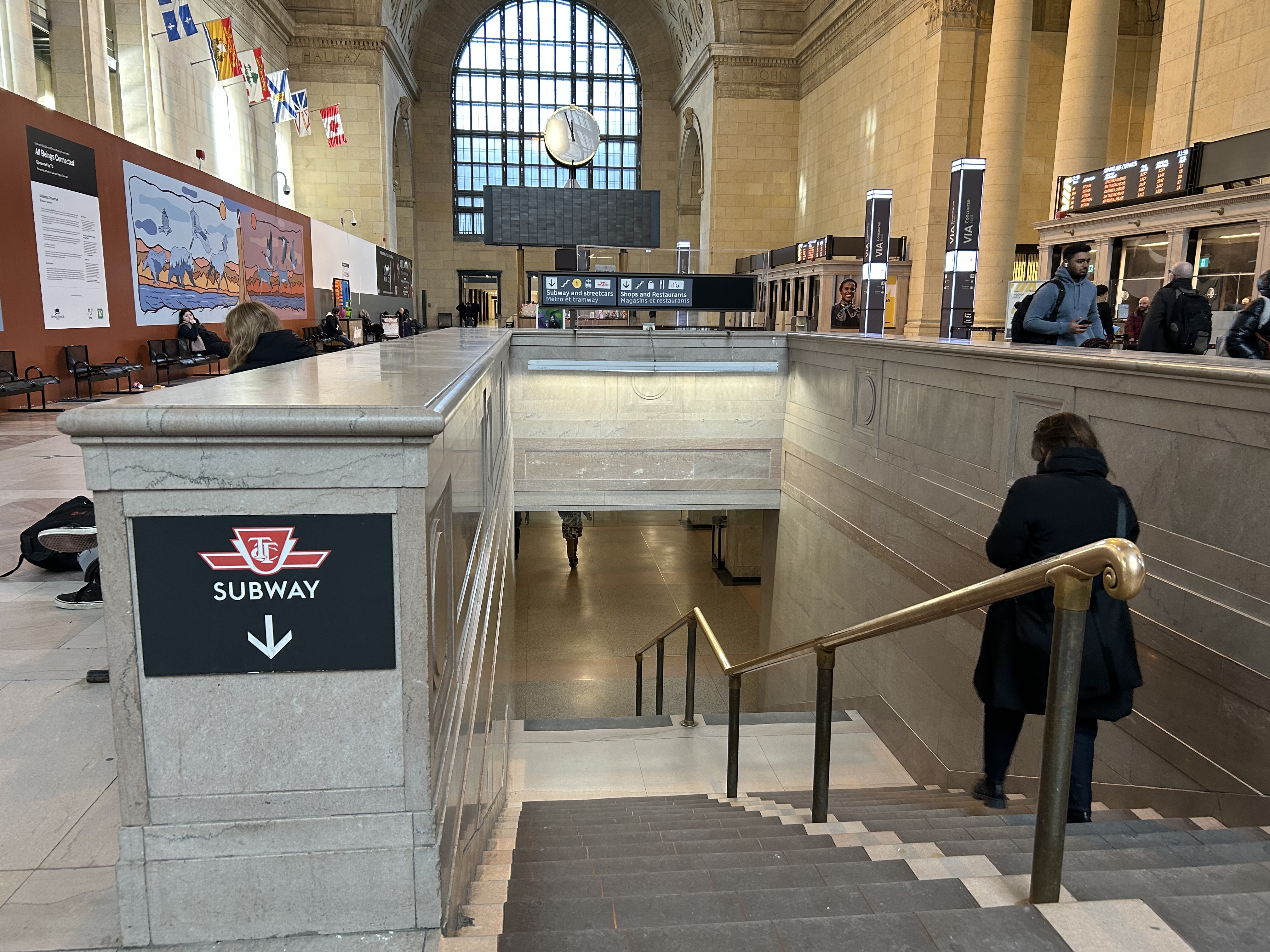
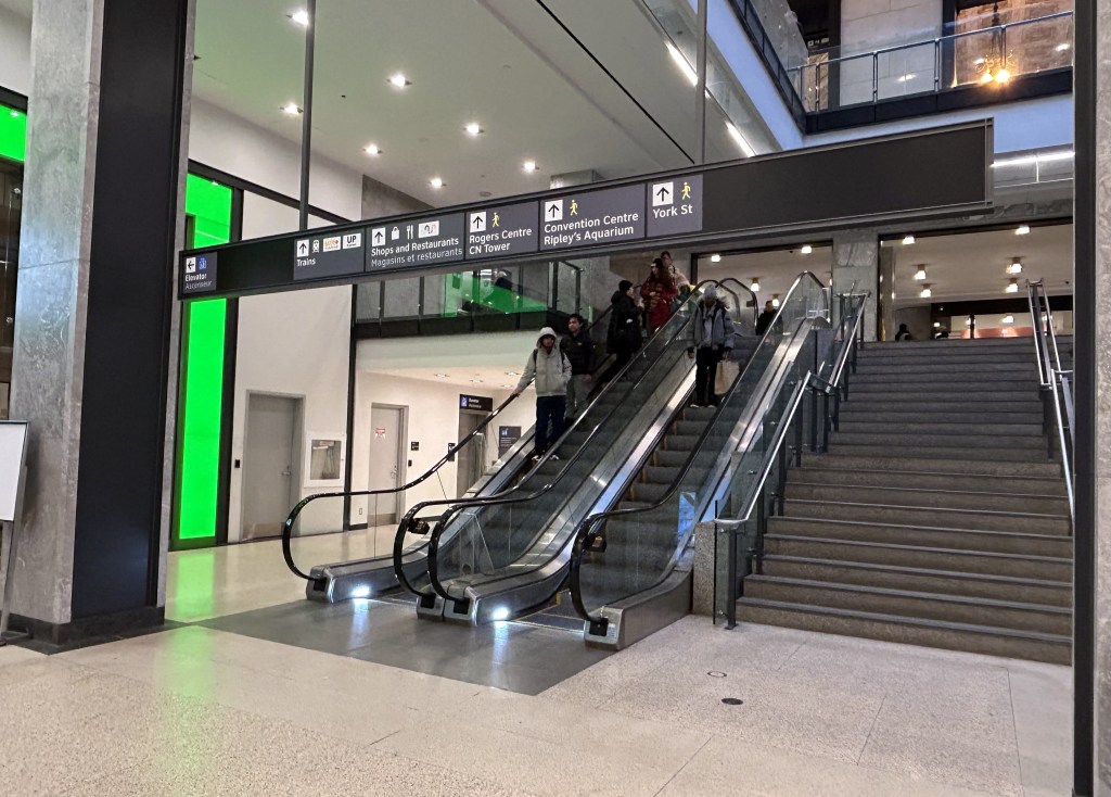
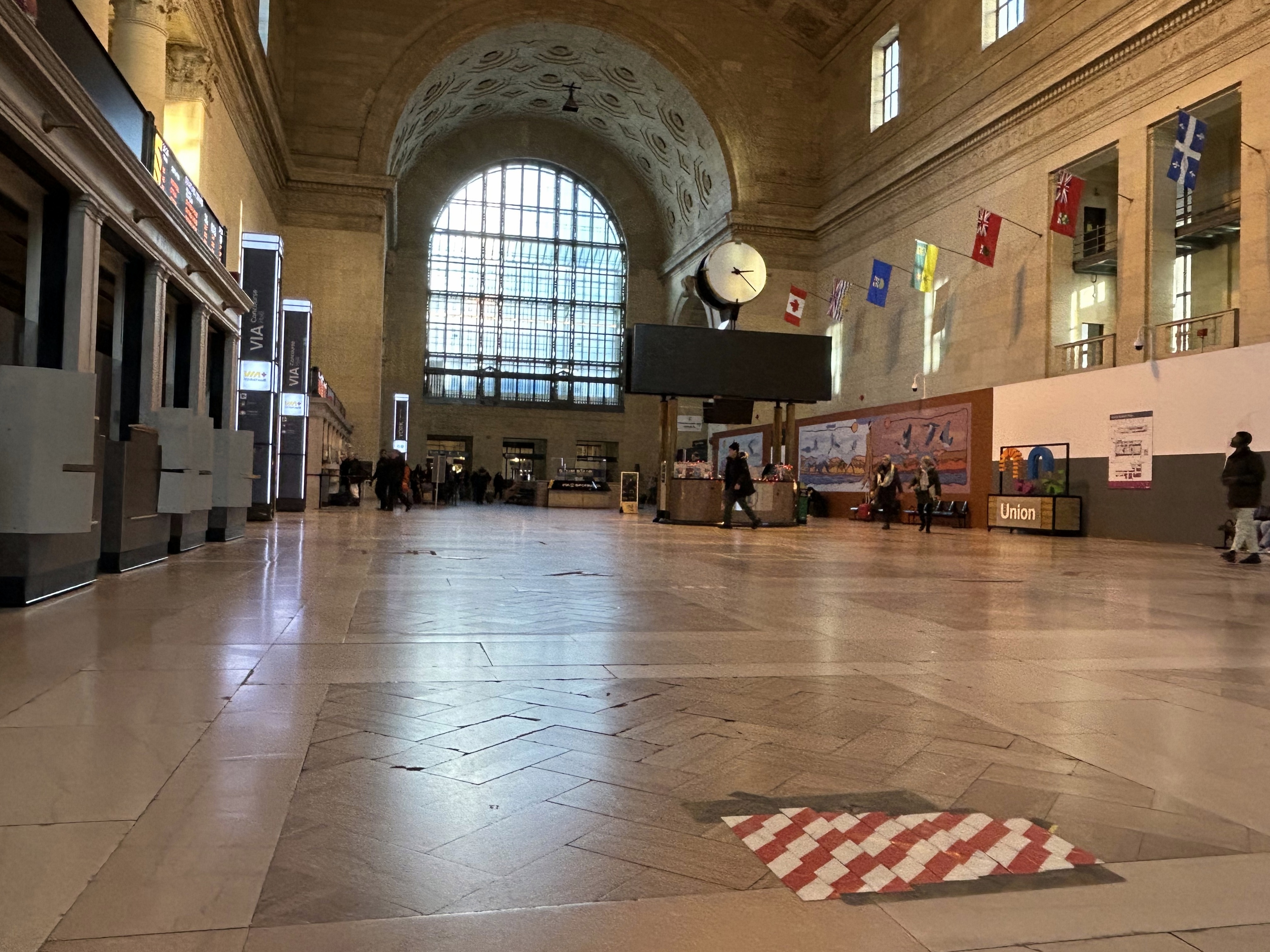
Last month, I wrote about the challenges getting around Toronto’s Union Station, Canada’s busiest transportation hub, particularly for passengers using mobility devices or carrying luggage. Only one poorly-marked elevator directly links the Great Hall and the UP Express platform with the subway station/PATH level, which is located two floors down.
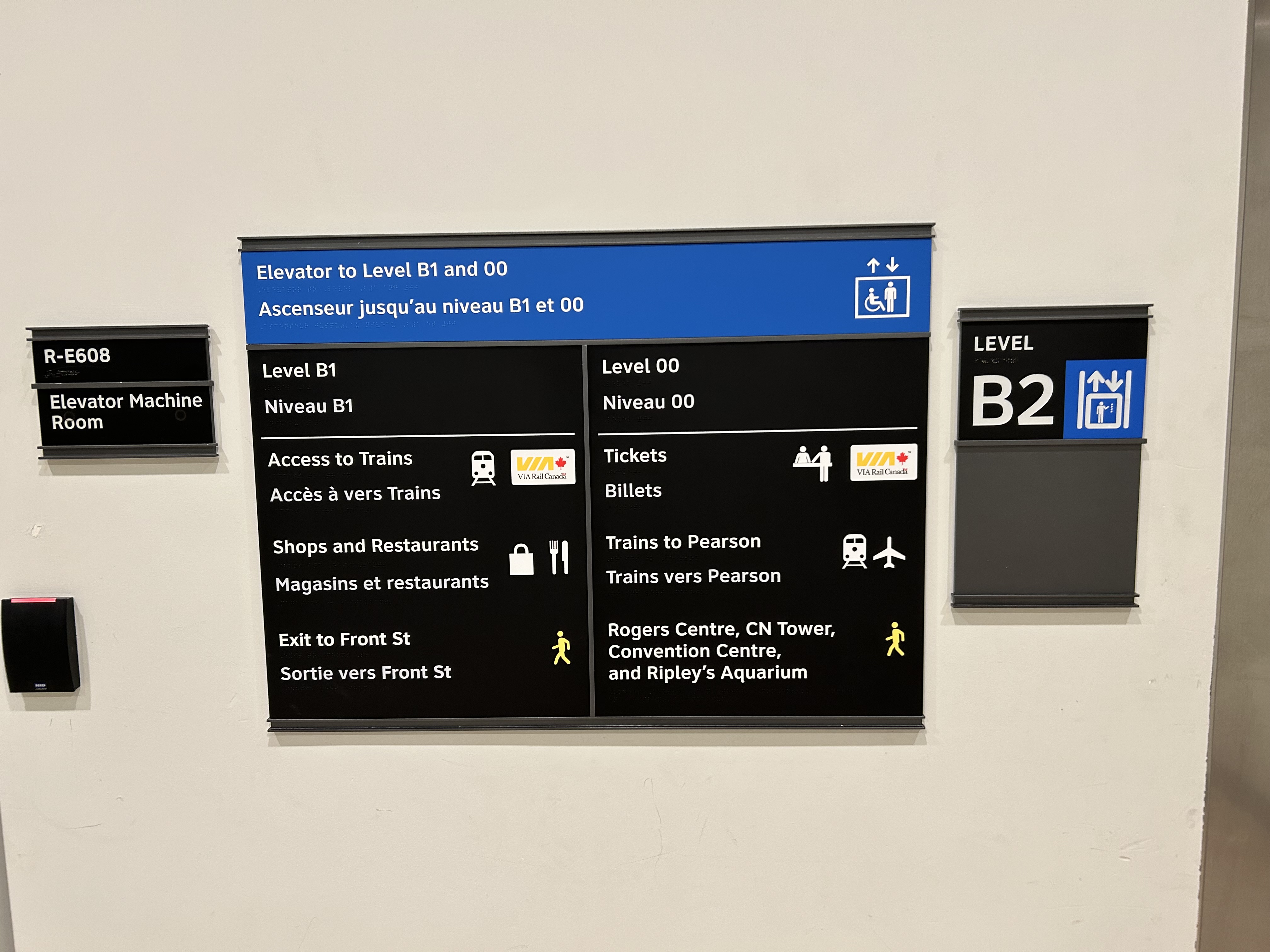
I returned to Union Station on Tuesday, January 7, to see if any improvements were made since I wrote my initial post. Somewhat surprisingly, new signs were installed beside the elevators, indicating which floor goes where.
Elevator signage at B2 level (subway concourse/PATH level by Bay Street) that indicates where the other floors lead to: Level B1 for VIA trains, shops and restaurants, and exit to Front Street, and Level 00 for VIA ticketing, UP Express trains, and access to the Skywalk to Rogers Centre, CN Tower et al.In the GO York Concourse, the elevator leads to Level 00 (The Great Hall) only.
These signs are a notable improvement, but there is still no signage inside the elevator cars themselves, so the traveler must note the directory signage before entering the elevator. Furthermore, the Great Hall, the historic centrepiece of the Union Station complex, is not noted, even though it is a logical meeting place from where access to all GO, VIA, and UP Express train services can be made, or where taxis can be found right outside.
Unfortunately, the elevators themselves are still difficult to locate, and the decision to have just one slow elevator connect the Great Hall/UP Express floor with the subway station entrance remains unfortunate. There is still so much more to be done.
In the Great Hall, there are clear signs directing passengers towards the subway, but there are no indications on where a barrier-free passage can be found. A supplementary sign pointing towards the one elevator, located at the far end of the Great Hall, could be useful here.
Previously on this website, I discussed the problems with the unsightly, intrusive, and poorly thought-out mess of Jersey barriers plopped in front of Union Station along Front Street. They have not only been an eyesore unbefitting a signature heritage structure, but they have also been difficult for pedestrians to navigate around, especially at the corners of Front and Bay and Front and York.
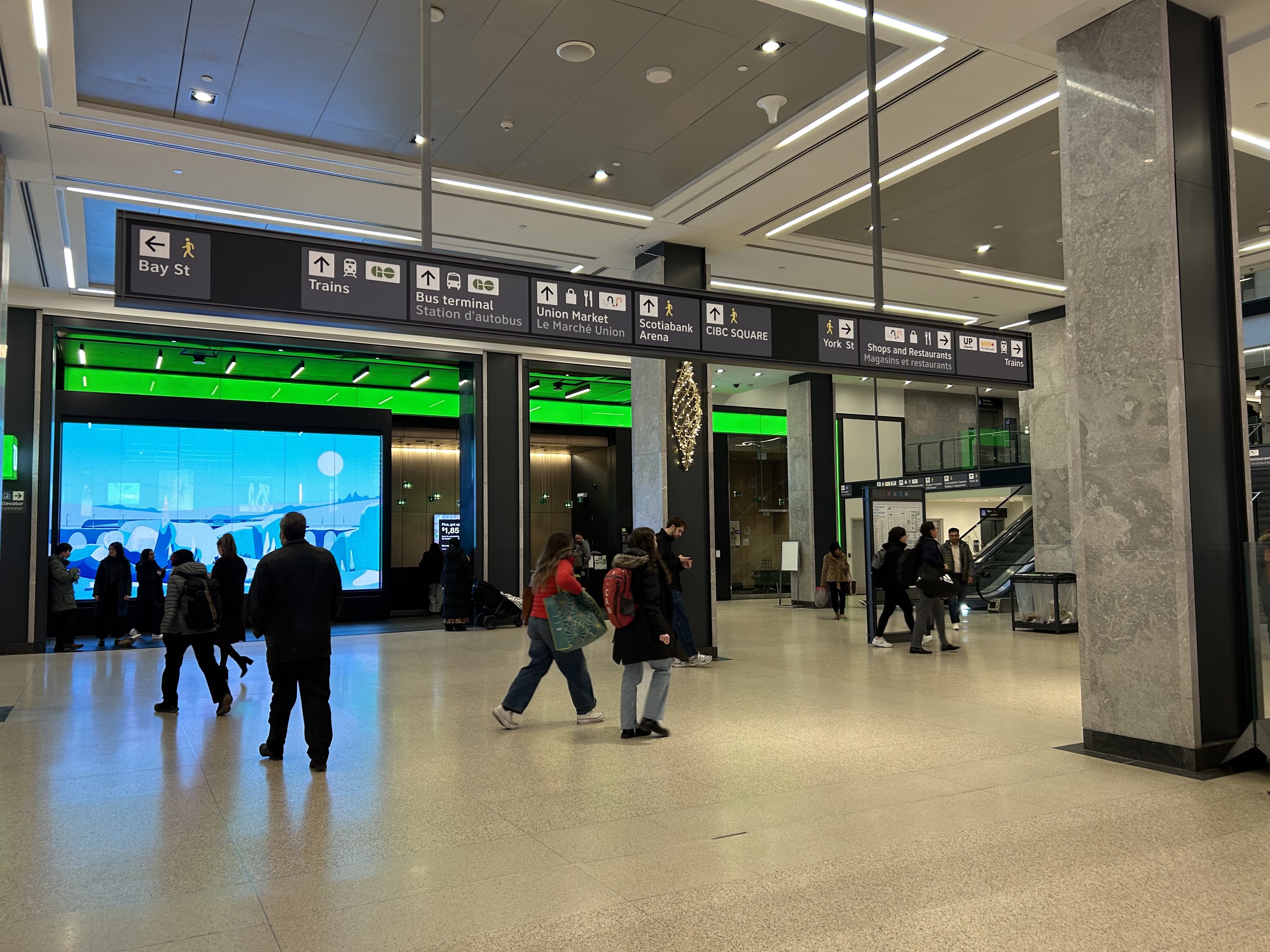
Inside Union Station, however, a lot has changed in the last few years. In general, pedestrian flow within the station building has improved, especially with the opening of the GO Transit York Concourse, which provides a second access point for regional trains. Flow between subway, train, and shops is considerably improved; there are also a lot more food and retail options befitting a central transport hub.
Despite new escalators and elevators, accessibility in Union Station remains poor. Though technically, the station is fully accessible to anyone using a wheelchair or other mobility device, the wayfinding is absent in key areas. There is only one small elevator that directly connects the subway level with the Great Hall, UP Express trains, and Front Street. An accessible route is also difficult to find.
The view after entering the Union Station complex from the TTC subway. The overhead sign shows the way to GO trains, the bus terminal, the Union Market shopping area, Scotiabank Arena, CIBC Square (an office building), York Street, more shops and restaurants, and VIA and UP Express trains.
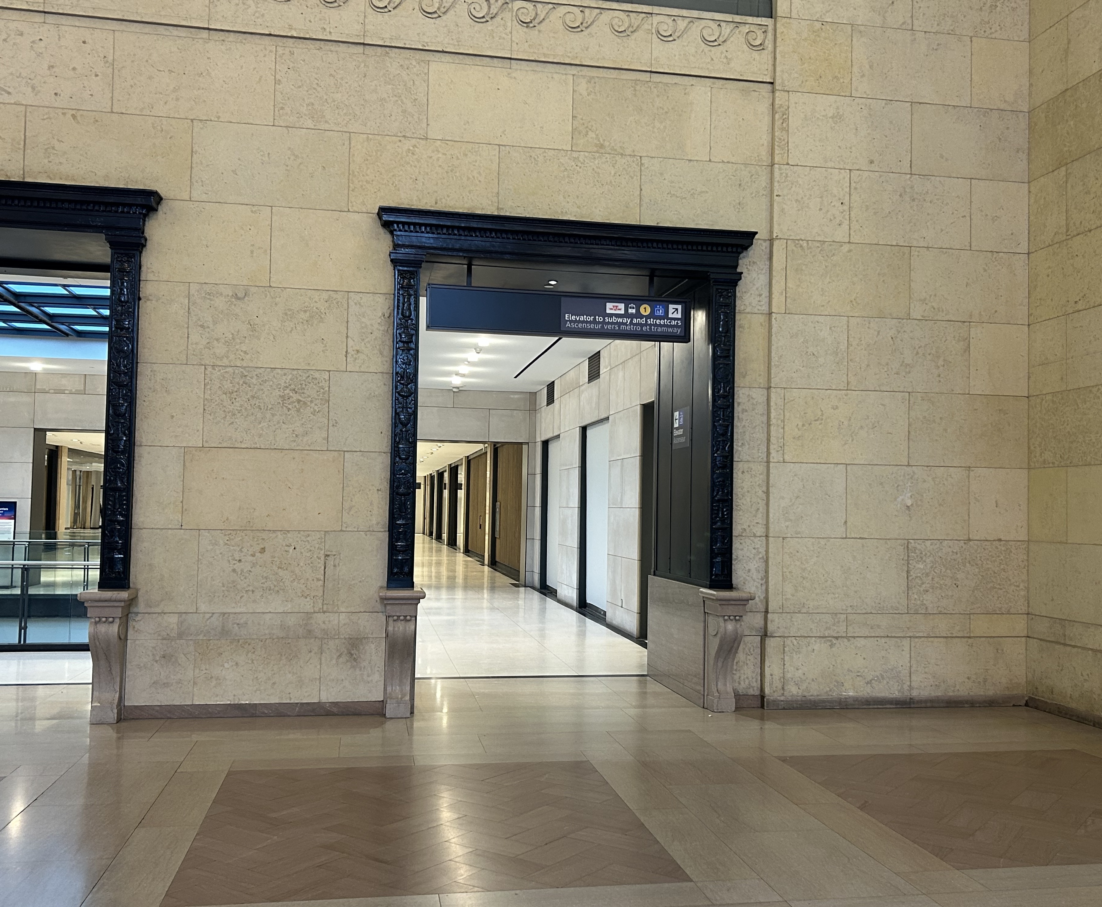
Imagine entering Union Station from the adjacent TTC subway station with a wheeled device or a mobility aid. There is a large concourse with signs leading forward towards the GO Transit York Concourse along with Scotiabank Arena, the bus terminal, and Union Station shops and food kiosks. To the left is Bay Street, and to the right are a set of escalators and stairs leading up towards VIA Rail and UP Express trains. Behind the stairs and escalators is a single elevator, hidden away.
To the right is a set of escalators, stairs, and hidden behind, a poorly marked single elevator.These lead towards UP Express and VIA trains, York Street, and attractions such as the CN Tower, the Convention Centre, and Rogers Centre.
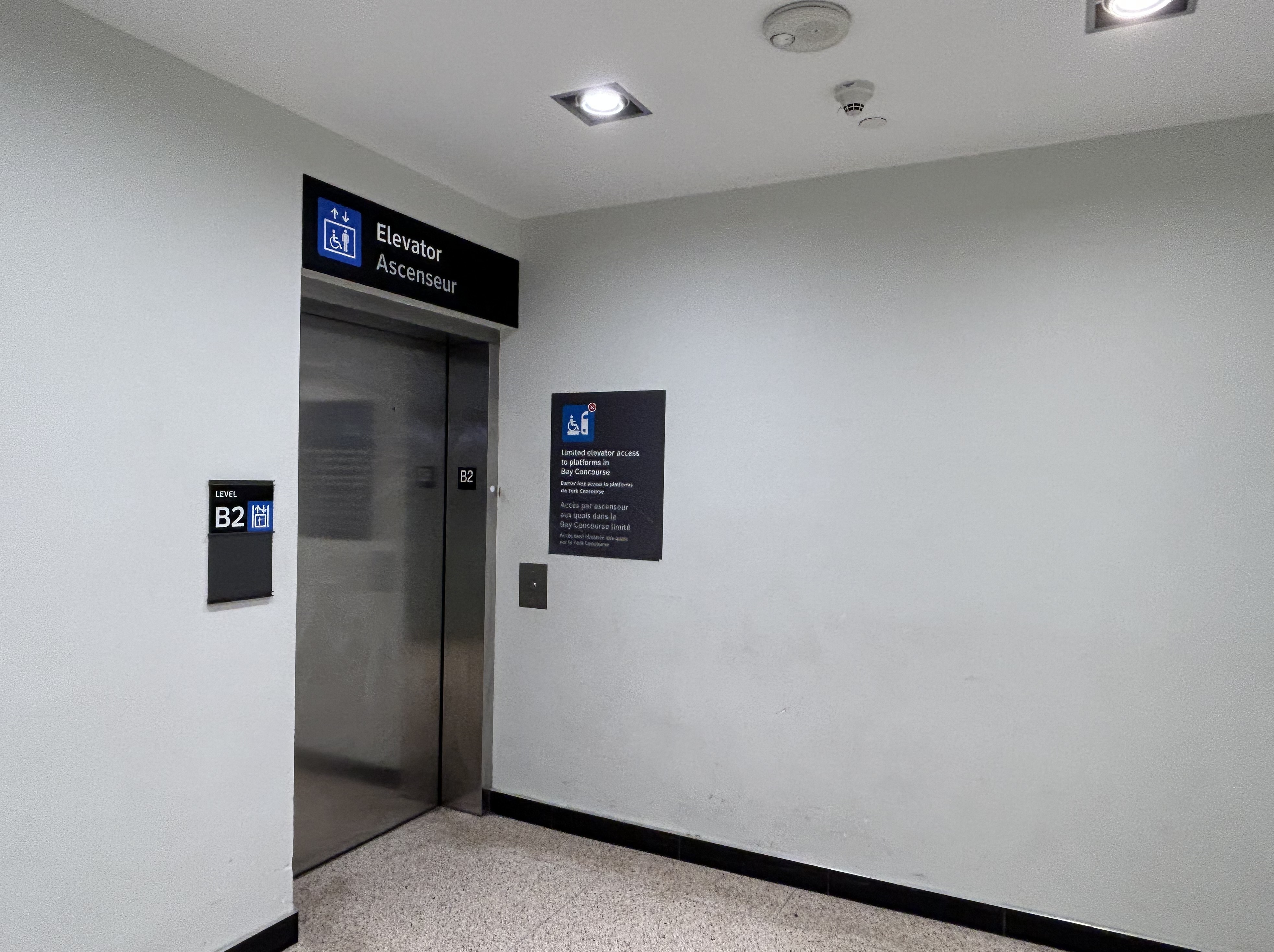
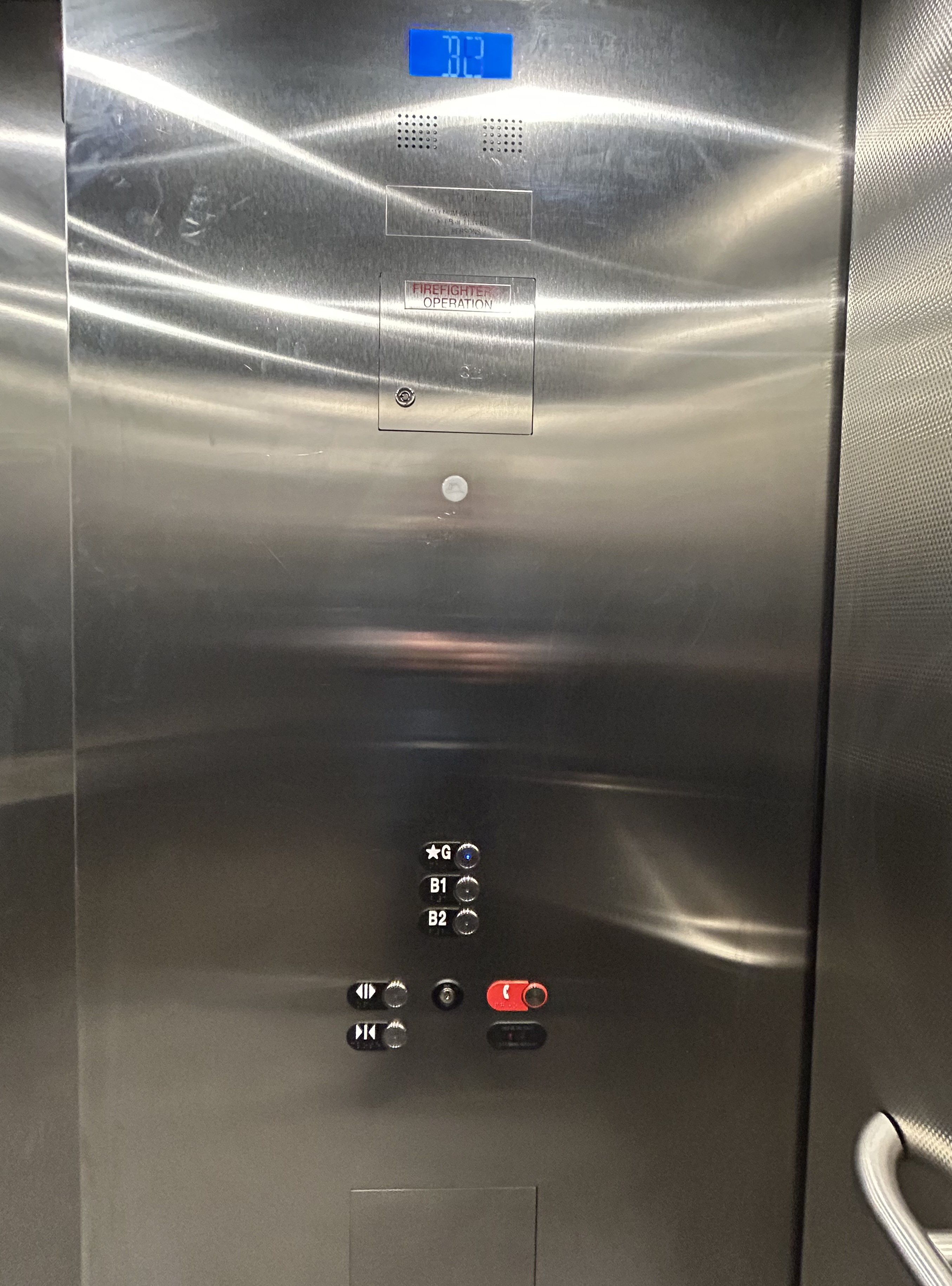
The elevator provides no information other than a sign that indicates that this is, in fact, an elevator, and this is the B2 level. This is a single, small elevator, which operates slowly.
The elevator at the B2 (subway) level
Once inside the elevator, there is no information other than buttons marked “G”, “B1”, and “B2”. There is nothing to tell the elevator user what is accessible from each floor.
Confusingly, the official Union Station map directory calls the three levels “Street Level” (G, the Heritage structure including the Great Hall, West and East Wings, along with the path towards UP Express and the Skywalk), “Lower Level” (B1, the GO York and Bay Concourses, the concourse beneath the Great Hall, and the VIA departure area) and “Retail Level” (B2, including the food court, food hall, and connections to the subway). In the elevators, the audio prompts only mention the three level names.
Inside the elevators, there is no indication what each level is, or where they lead to — the buttons and empty spaces beside them just show G, B1, and B2 levels
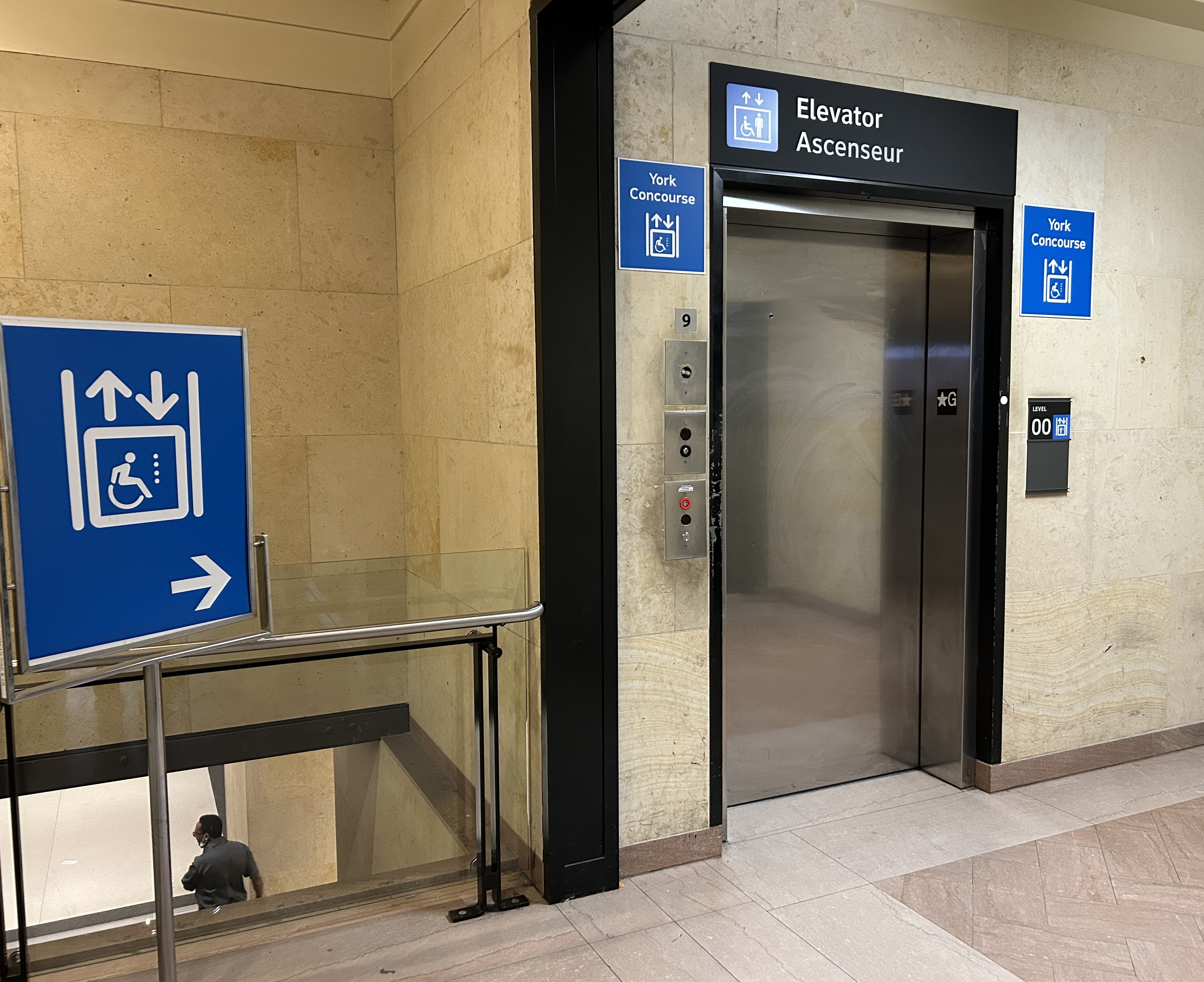
At G level, which includes the Great Hall, VIA Rail departures and business class lounge, and the passage west towards UP Express trains and the Skywalk to the CN Tower and Rogers Centre, the elevator is also hidden behind a wall.
The only elevator connecting the Great Hall, the lower concourse, and the subway level is hidden, with tiny signage directing travelers to it
On the west side of The Great Hall, there is also an elevator, beside the stairway down to the GO Transit York Concourse. This elevator does not serve level B2.
York Concourse elevator, on the west side of Union Station’s Great Hall
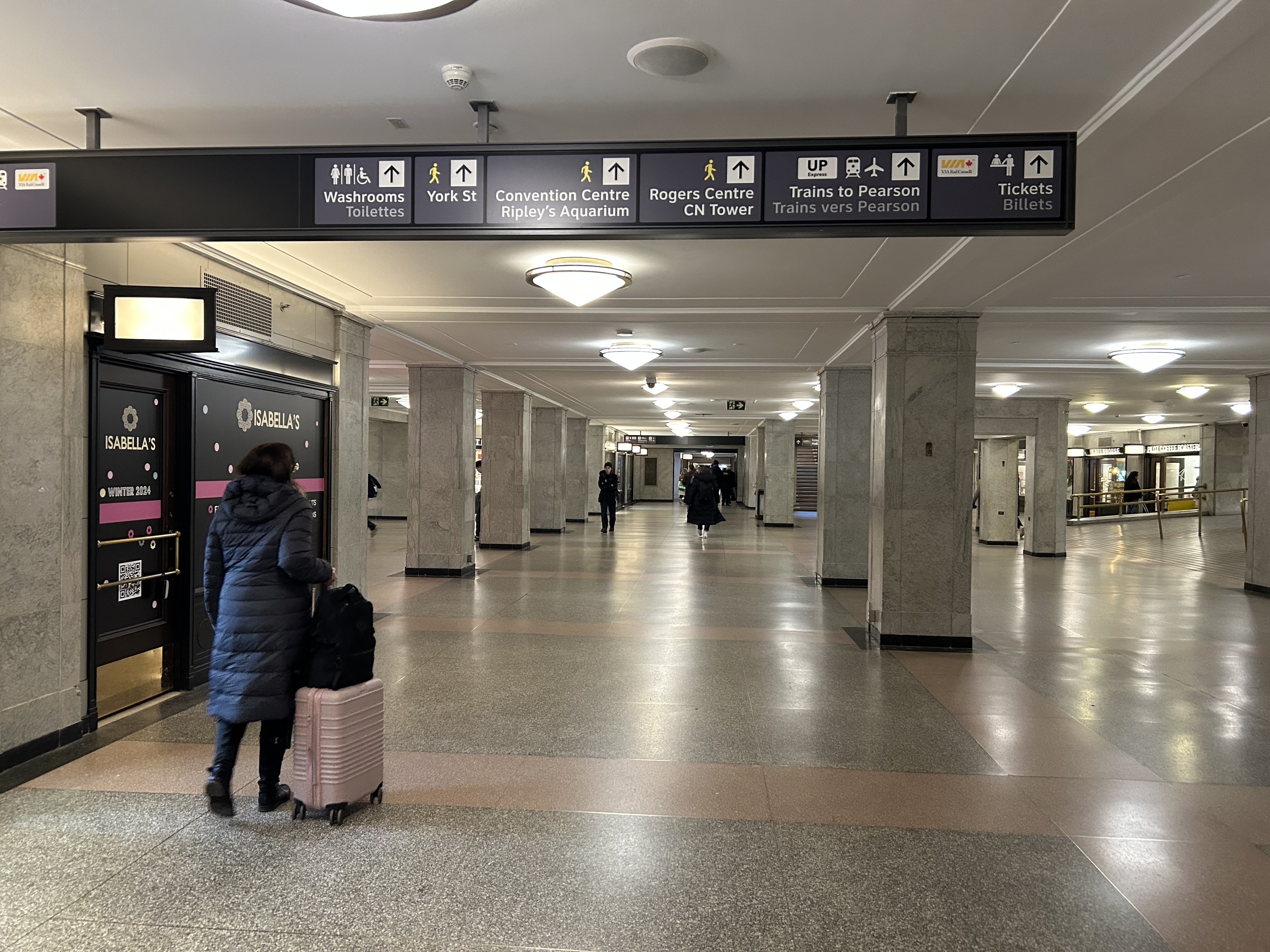
If the traveler was only connecting from subway to UP Express with a heavy bag, and not using a mobility device, they might decide to take an escalator from the subway B2 level to the B1 level, the lower Union Station concourse originally intended as an arrivals area for intercity trains. However, there is no elevator or upwards escalator to be seen.
Looking west in the lower concourse, towards York Street and UP Express trains
If one knew Union Station well, they could make a lengthy detour through the ramps in the VIA Rail area to get to the Great Hall or go around through the GO York Concourse to reach the elevator or up escalator to the Great Hall. But these routes are not marked from the lower concourse area.
To show how difficult it can be to navigate the station while using a wheeled device (be it a wheelchair, stroller, or wheeled luggage), I shot this video showing how a first-time visitor getting off an UP Express train from Union Station would try to find the TTC subway entrance.
Video depicting 9-minute trip at a normal walking speed between the UP Express area and TTC subway station entrance, using first available elevators each time.
At no point was there any visible signage showing the most direct route for someone requiring a barrier-free path from UP Express to the subway. The maps below show the route I took:
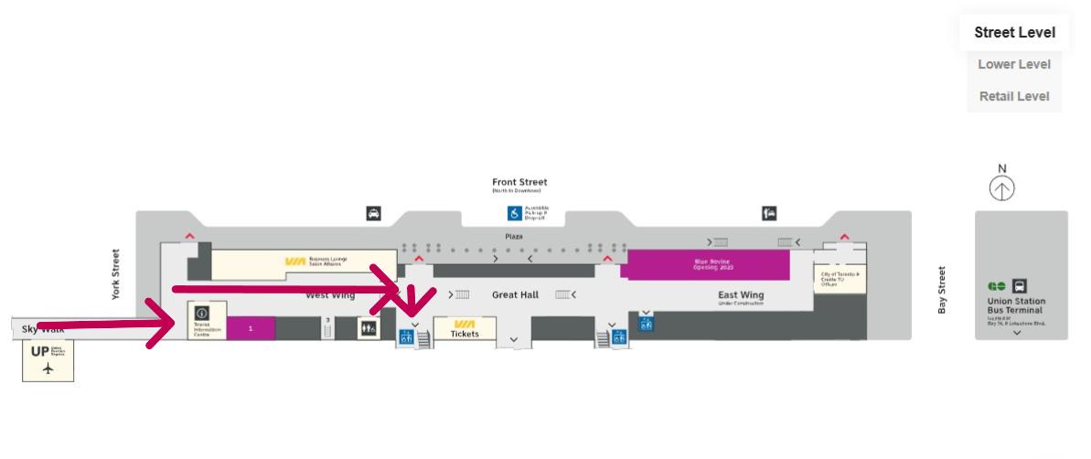
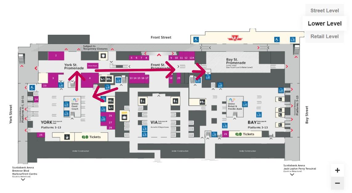
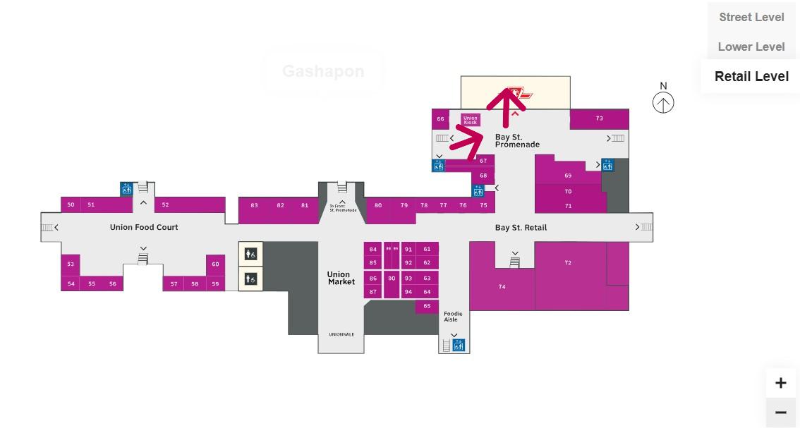
Route from UP Express to the Great Hall and York Concourse Elevator (Street Level, or G). Arrows are added to mark the route I took in the video.Path through York Concourse, lower Union Station concourse (Front St. Promenade) – the B1 Level, and to the second elevator to the Bay St. Promenade (subway level). Arrows are added to mark the route I took in the video.Last part of the trip on the Retail Level (B2) to the subway station entrance. Arrows are added to mark the route I took in the video.
Whenever I travel through an international airport — Toronto Pearson is a good example — I never have to think too hard about where the accessible routes are. Escalators are easy to find. There are banks of two or three large elevators in strategic locations on the ground side of airports, connecting departure and arrival areas, as well as ground transportation facilities. As Canada’s busiest transport hub — busier than Toronto Pearson Airport even — Union Station’s elevators and escalators should be plentiful and easy to find.
I am aware that there are particular challenges at Toronto Union Station — the City of Toronto controls only the common areas, such as the Great Hall, the retail areas, and the main entrances. Metrolinx, the agency responsible for GO Transit and UP Express, controls the York and Bay Concourses, as well as the UP Express station area. VIA Rail maintains its departures area. There are also heritage elements that need to remain intact, such as the Great Hall. But these issues of ownership and heritage preservation do not excuse the difficulty of getting around with a mobility device or even a wheeled bag.
Why weren’t multiple elevators installed connecting all three levels, to improve capacity, speed, and provide redundancy in the case of an elevator outage? Why are there not easy-to-find elevators in the West Wing near the UP Express area?
Judging by the condition of the signature Great Hall itself, there is work yet to be done before Union Station is fully restored to its 1920s grandeur. It should not be too hard to improve accessibility and wayfinding as well. Not just for Torontonians, but for international travelers too.
The Great Hall floor is still cracked and patched, with electrical tape covering some of the damaged sections


