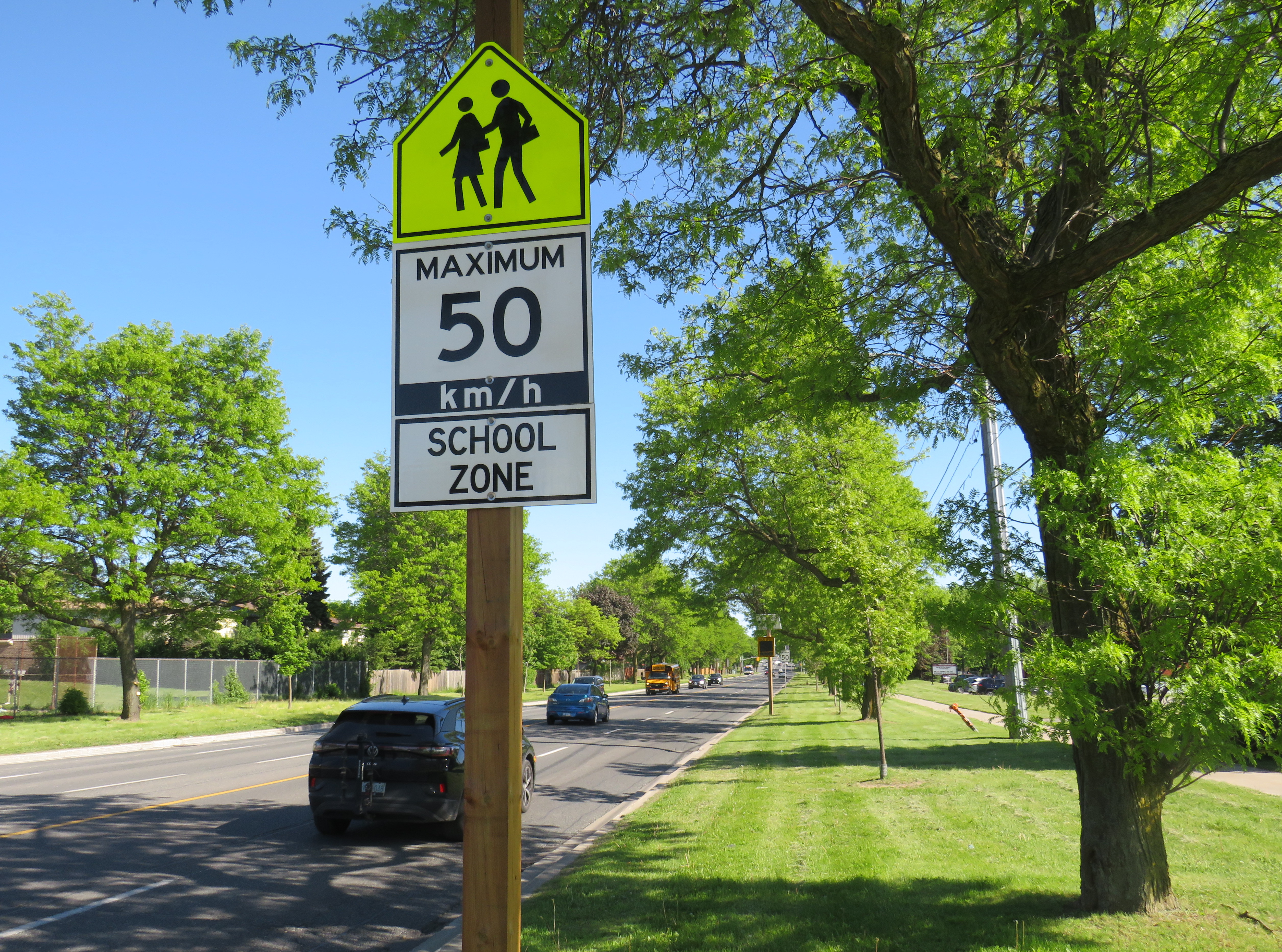
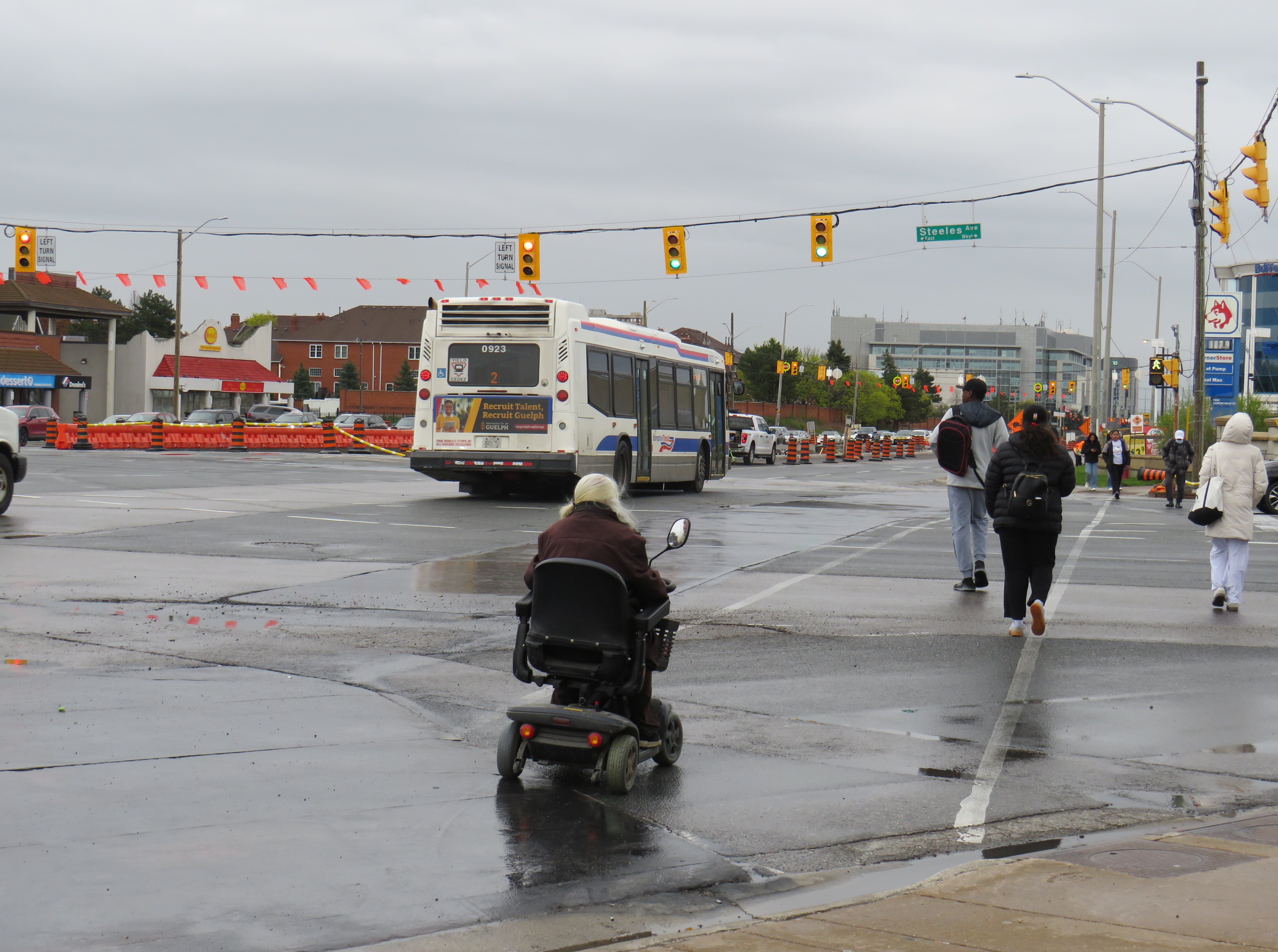
A gigantic school zone speed limit sign on McCowan Road in Scarborough
Months after Doug Ford’s provincial government banned the use of municipal speed enforcement cameras, calling it a “cash grab,” new supersized school speed zone signs are going up across the province. The first ones I encountered are on McCowan Road in Scarborough, near my spouse’s family home.
The signs, placed near St. Ignatius of Loyola Catholic School south of Finch Avenue, are gigantic: nearly 2.5 metres tall, mounted over three metres above the ground, affixed to an extra large wooden pole as the new signs were too big for the standard metal poles used for that purpose. The province delivered 80 signs to the City of Toronto, but with four signs per school zone (two mounted in each direction including advance warning signs), that meant only 20 schools would get these new totems.
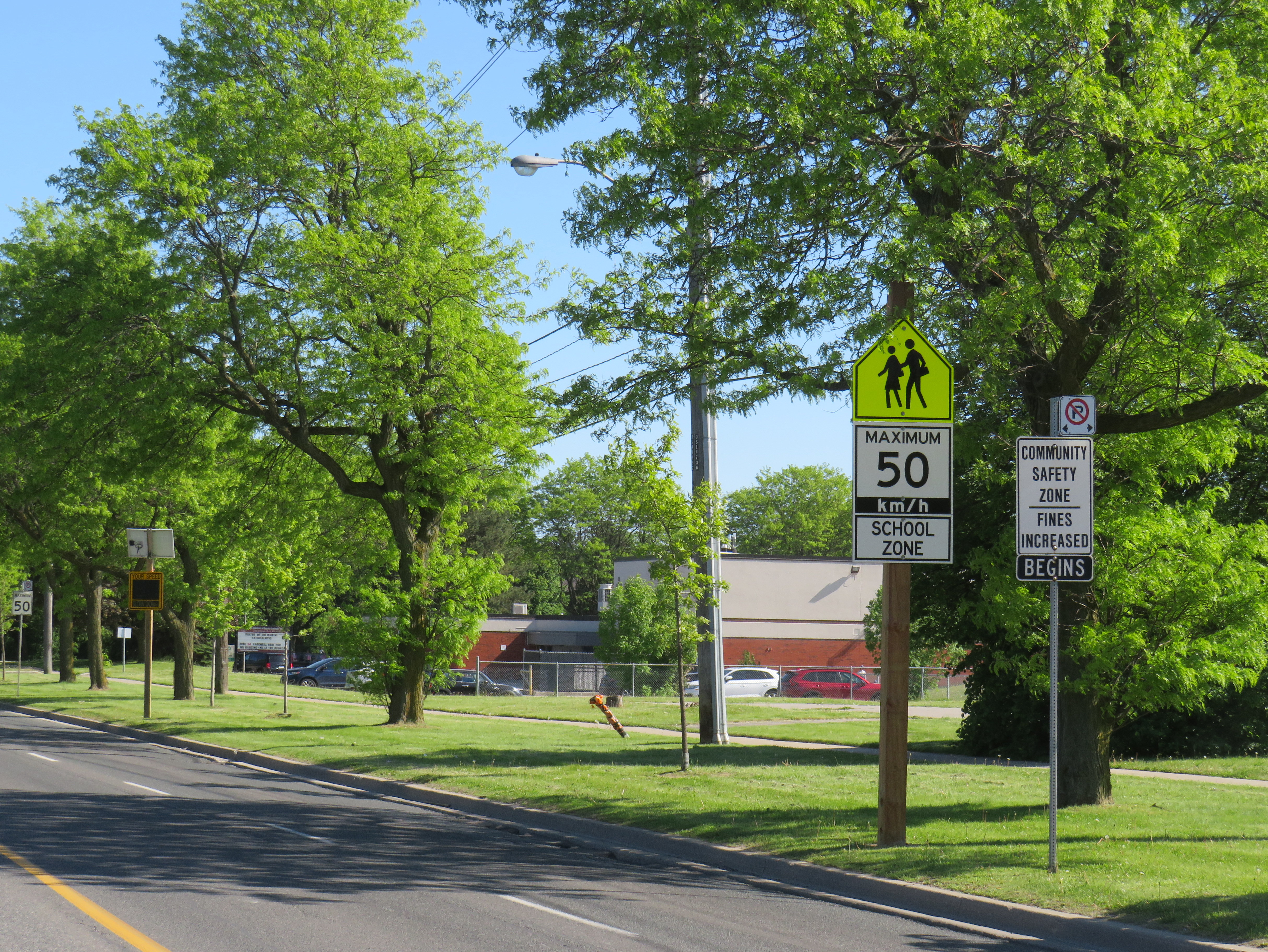
The new supersized school zone sign next to an older “community safety zone” sign, affixed to a standard metal sign pole
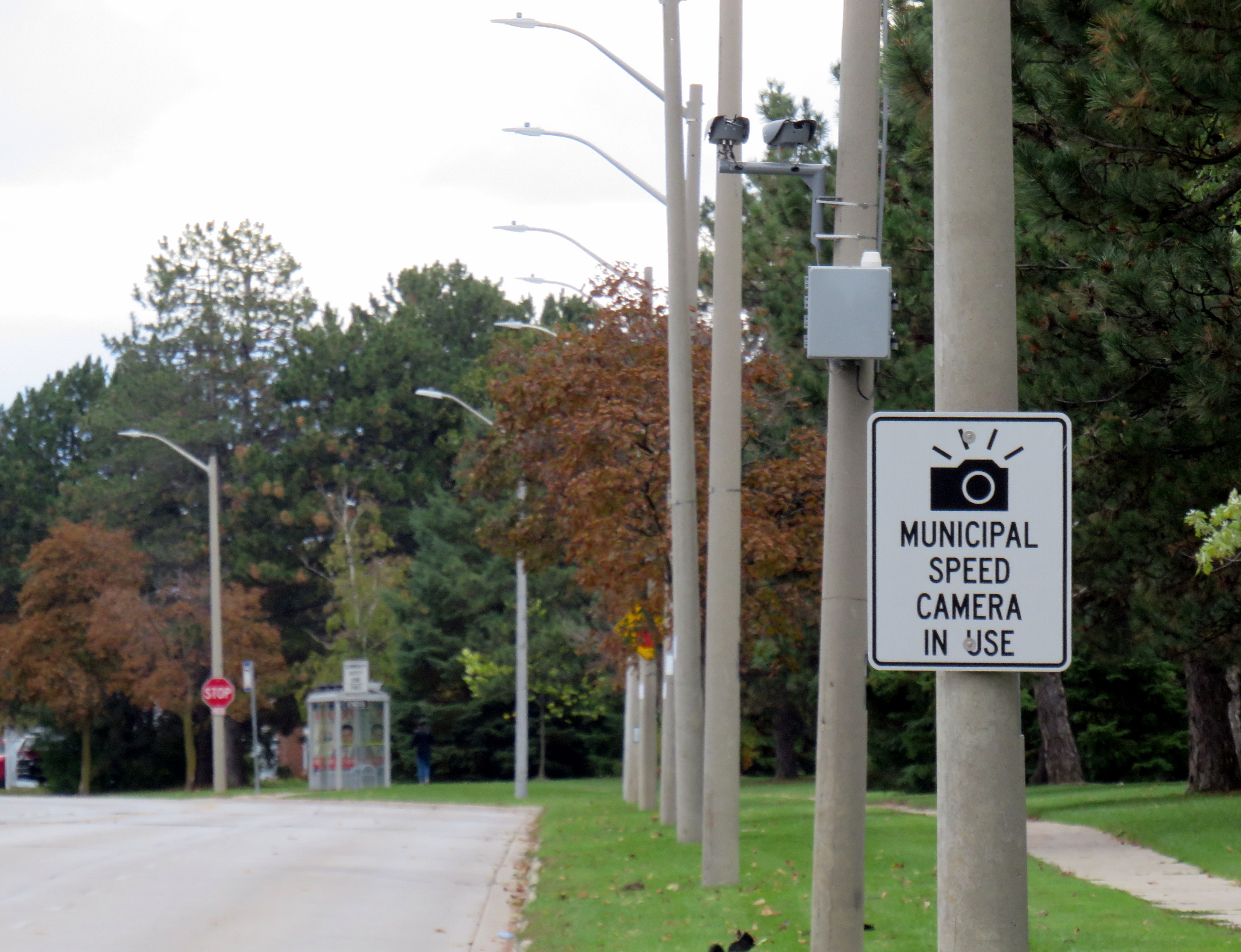
Before the pro-driver legislation was enacted on November 14, 2025, there was a speed camera placed on McCowan Road adjacent to the elementary school, one of 150 located in the City of Toronto. Under provincial law, municipal speed cameras were only allowed to be installed in specific designated safety zones, namely roadways adjacent to schools, parks, or seniors’ residences, and had to be accompanied with advisory signage.
Between April 2024, when the camera was activated, and July 2025, when the camera was destroyed (one of many vandalized that year), over 19,000 speeding motorists were captured by the photo camera travelling at least 11 km/h over the posted speed limit. This was despite the existing maximum speed, school zone, community safety zone, and municipal speed camera signs on this stretch of road.
Sign warning of a municipal speed camera in Brampton in October 2025
Despite the high number of infractions, the cameras were doing their job; a job that the Toronto Police isn’t motivated — or able — to do. As seasoned municipal watcher Matt Elliot points out, for period between January 1, 2025 through November 14, 2025 (when camera enforcement was forced to end), 628,165 speeding tickets were issued through the automated speed enforcement program. Toronto Police’s “Vision Zero” traffic unit issued just 14,500 tickets.
New city report notes the Toronto Police Vision Zero Enforcement Team handed out about 14,500 speeding tickets in 2025. Might sound like a lot, but well, compare and contrast.
Despite all those tickets issued, the cameras were especially effective at reducing speeding in school zones. A 2025 Toronto Metropolitan University/SickKids Hospital study found that speed enforcement cameras reduced speeding by 45 per cent and reduced speeds by most drivers by more than 10 km/h.
Active police enforcement remains a valuable tool because officers can lay charges that automatic speed cameras can not catch, including distracted, impaired, and dangerous driving. But policing has a dark history of racial profiling and has a pro-motorist “windshield bias,” while speed enforcement and red light cameras do not discriminate.
Furthermore, North American roads are designed for excessive speed and not for the safety of vulnerable road users. We rely on signs to advise motorists of how we expect them to drive, rather than road design that requires attentive and slower driving. Speed cameras were a useful stopgap that worked a lot better than signage.
So, the new supersized signs going up are not a solution to unsafe driving: they are just another mere indication that children, seniors, and all pedestrians and cyclists don’t really matter, especially to politicians like Doug Ford.
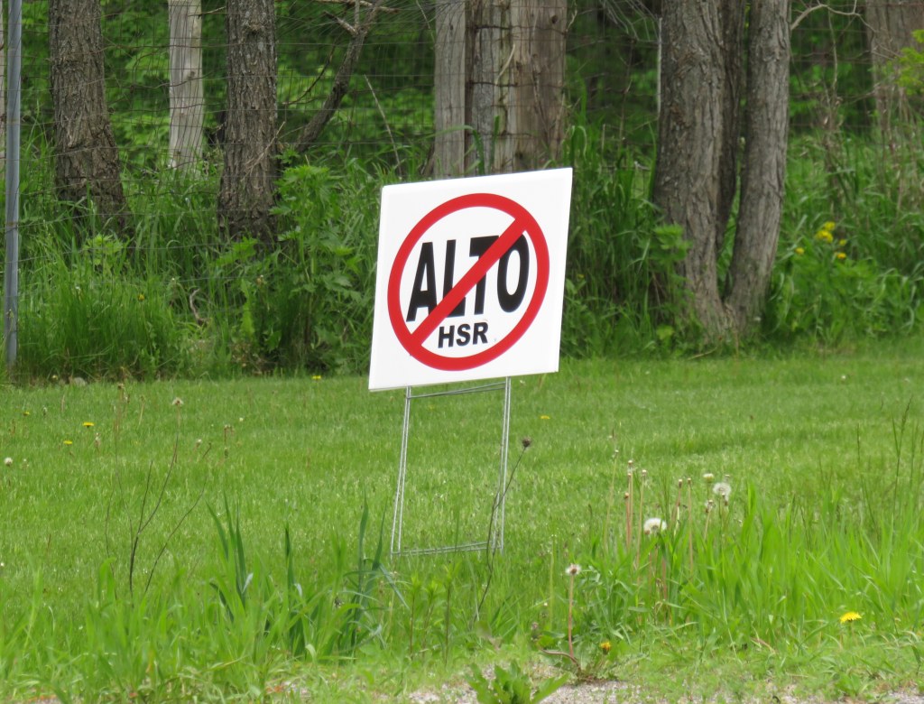
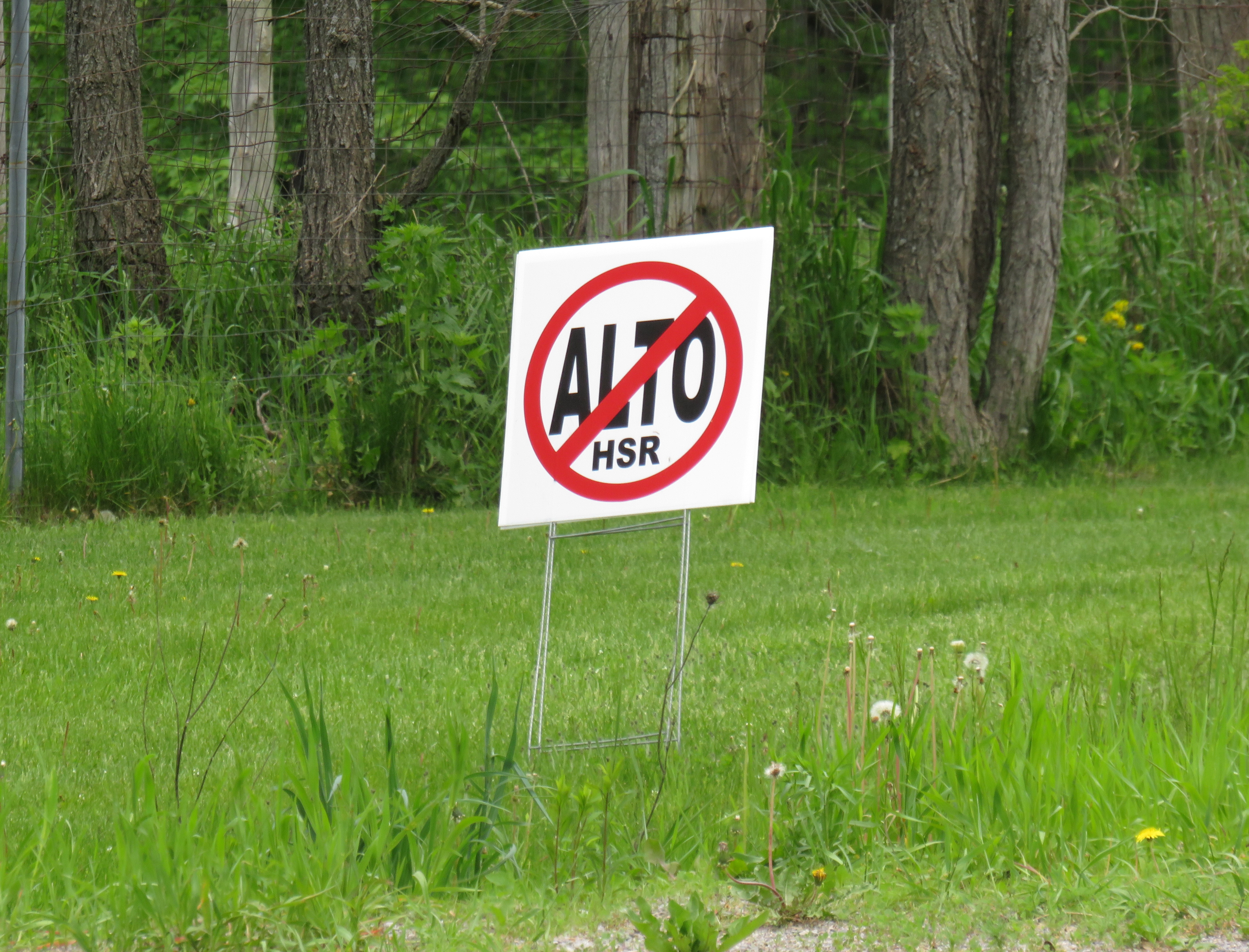
A “No ALTO HSR” sign on a property near Marmora, Ontario
There’s a running joke that Canada leads the world in high speed rail studies, but we never follow through with actually building those high speed lines. Comedian Rick Mercer had at least two sketches on his old weekly CBC television show mocking this state of affairs, as the idea goes back to the 1970s.
“VIA Rail: Yesterday’s speeds, today.”
“Canada’s High Speed Rail Study Industry: The future, never!”
In 2026, however, Canada is finally past the high speed rail study phase and appears to be committed to building the seven-station corridor between Toronto, Ottawa, Montreal, and Quebec City, with a consortium selected that is already planning the detailed route. It’s an exciting time as the first phase, between Ottawa and Montreal, should start construction in three years once the exact corridor is decided upon and land acquisition has begun.
High speed rail, if done right, should benefit Eastern Canada as a whole. Fast and frequent train service will divert a lot of the travel in the busy Toronto-Montreal-Ottawa triangle from the air, reducing emissions and allowing existing airports to handle any increases in long-haul demand. Faster and more reliable passenger train service would also take traffic off the highways and boost commerce within the most populated part of the country. If done right, it will also support plans for better transport infrastructure outside the corridor to Southwestern Ontario and provide Canadian expertise for other projects such as in Alberta, which is contemplating its own passenger rail network between Calgary and Banff and north to Edmonton.
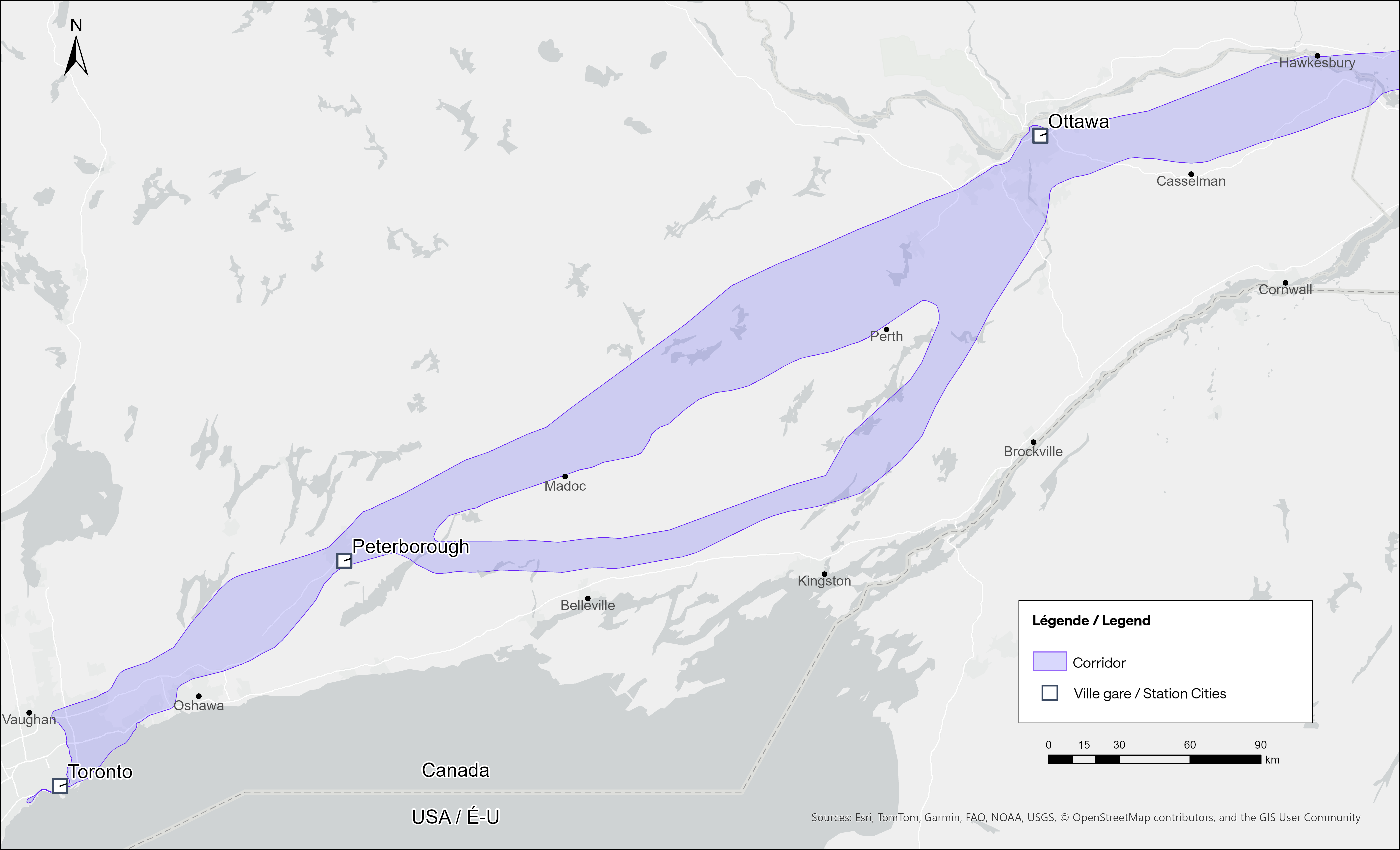
Map of potential routings for the Alto high speed line in Ontario
Not unexpectedly, there is opposition from residents and landowners along the route, especially in Eastern Ontario and the area of Quebec just northwest of Montreal. In Hastings County, north of Trenton and Belleville, there are a few dozen “No Alto HSR” signs on lawns and farms in places like Madoc, Marmora, Stirling, and Tweed. In this part of Ontario, between Peterborough and the Rideau Lakes region southwest of Ottawa, there are two broad potential routes: a southerly corridor runs near Campbellford, Stirling, Tweed, and Westport, including through some productive farmland in Northumberland and Hastings Counties. A second route runs north of Highway 7, just north of Madoc and Perth, along the southern fringes of the Canadian Shield.
Though a high speed railway line would be straight and relatively narrow, it would require the acquisition and severance of hundreds of properties. Along the existing CN and CP railway corridors to the south constructed in the 1850s and 1900s, there are frequent public road and private-access level crossings, something that is not possible with modern high speed trains passing at up to 300 kilometres per hour, so farmers whose land is crossed by the new high speed railway corridor may not be able to access parts of their property easily. Furthermore, there are no stops planned between Peterborough and Ottawa, a distance of over 250 kilometres.
In Prescott & Russell Counties in the Lower Ottawa Valley, even the local governments are opposed to Alto crews doing early survey work to determine an optimum route, with county warden Mario Zanth clear on the matter: “This council does not want them on our territory.” For now, Alto surveying is mostly done by way of drones over land where landowners have not granted access.
Once a more specific route is selected, hopefully some of the opposition will fade. Detailed design work and further consultation should also help mitigate concerns. This is especially important west of Ottawa, where there are the two diverging routes.
Despite the rural opposition, Alto should go ahead. Other major infrastructure projects, especially new highways, can be far more disruptive to local land use. But without local community benefits — at least a new freeway has regular access points — it will be harder to get buy-in.
Therefore, this needs to be a matter of “Alto and” than just “Alto” by itself. This means building and maintaining a supporting network of conventional VIA service, intercity and regional buses, and local transit connections. It might also mean adding a few additional stations along the route, in places such as Perth. Adding additional stops doesn’t have to slow down trains at all; Japan’s Shinkansen has three classes of trains, from the super-express Nozomi to the all-stops Kodama. While most passengers would be through Toronto-Ottawa-Montreal travellers, offering additional stops for select trains can make Alto more accessible to more people, especially if it means providing new options to underserved communities.
An express train passes the local Odawara Shinkansen Station in April 2019
If Alto becomes the backbone of a strong, integrated transportation network in Ontario and Quebec, the benefits will go far beyond those in the six cities directly served the planned high speed line, even to those directly bypassed by Alto trains. This integration is commonplace in Japan and Europe.
In Kingston, for example, a new or upgraded VIA station with additional tracks and platforms would allow for early morning departures and late evening arrivals from Toronto, Ottawa, and Montreal without having to sit on active CN freight tracks overnight; VIA schedules built around serving cities like Belleville, Kingston, and Drummondville would ensure the existing service remains vital as through passengers switch to the faster line. A new Kingston station near Division Street could integrate rail and bus services, with easy access to Highway 401, with local and regional buses to places like Gananoque. Enhanced bus connections to the rest of the Ottawa Valley from the Ottawa Alto/VIA Station could allow travelers from Pembroke, Arnprior, or Hawkesbury to quickly continue their journeys via train. At Trois-Rivières, there should be seamless connections to places like Shawinigan and Victoriaville. The Canada Intercity Transportation Map on this website shows which communities are unserved or underserved by bus and rail: these include many towns in Southern Ontario and Quebec that are within 100 kilometres of the Alto corridor.
Canada is right to invest in high quality and sustainable transportation infrasturure as a nation-building project, to boost the regional and national economy, and promote environmentally friendly travel options. But focusing only on Alto, without a strategy of leveraging the conventional VIA network and intercity bus connections to feed that network, can only limit the success of high speed rail. The communities in between deserve better.
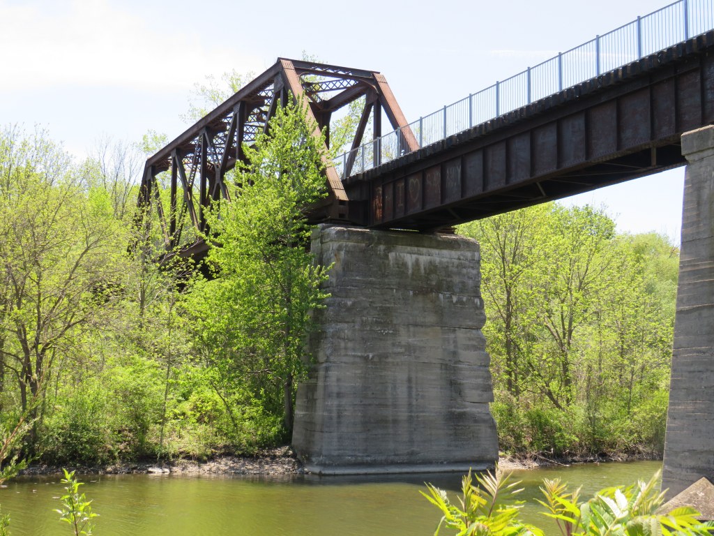
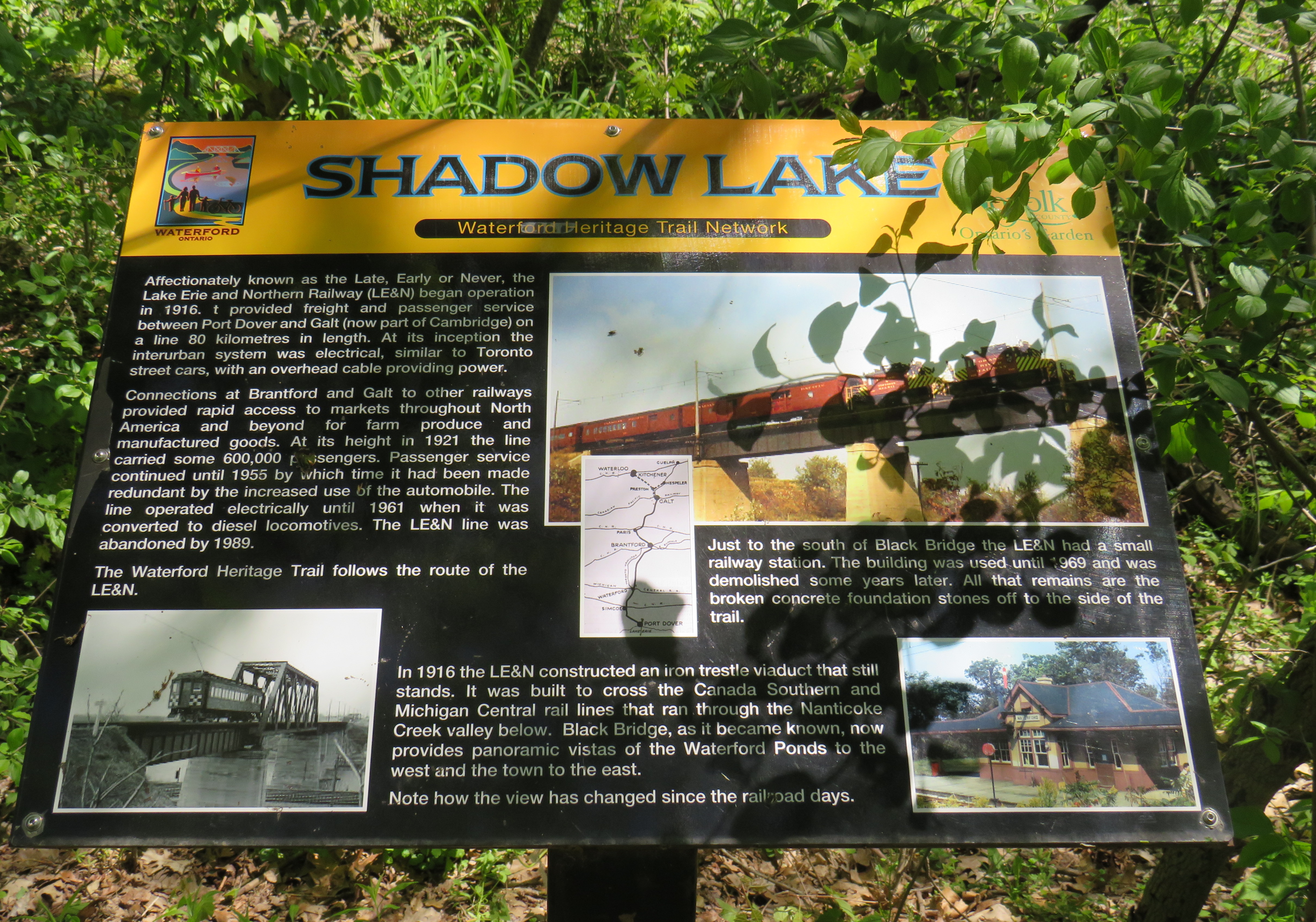
Looking down from the Black Bridge on the Norfolk County Trail to Shadow Lake and Waterford Ponds in May 2026
On a beautiful May Thursday, I met one of my colleagues in the village of Waterford. As he is now living in Port Rowan on Lake Erie, this was an opportunity for us to get some important work done, while also exploring one of Ontario’s great small communities.
Though the local area was settled over 200 years ago, Waterford was established as a thriving village with the arrival of the Canada Southern Railway (CASO) which was eventually incorporated into the giant New York Central system. The route through Canada, with its divisional headquarters in St. Thomas, was the fastest line between Buffalo, Detroit, and Chicago. It was joined by the Toronto, Hamilton & Buffalo (TH&B), which connected Hamilton and the Canadian Pacific Railway with CASO at Waterford and at Welland. In 1916, the electric Lake Erie & Northern (LE&N) Railway, another Canadian Pacific property, provided regular freight and passenger service between Port Dover, Brantford, and Kitchener. By the 1990s, all three railways were abandoned, but their former rights-of-way remain in active use as part of the local trail network.
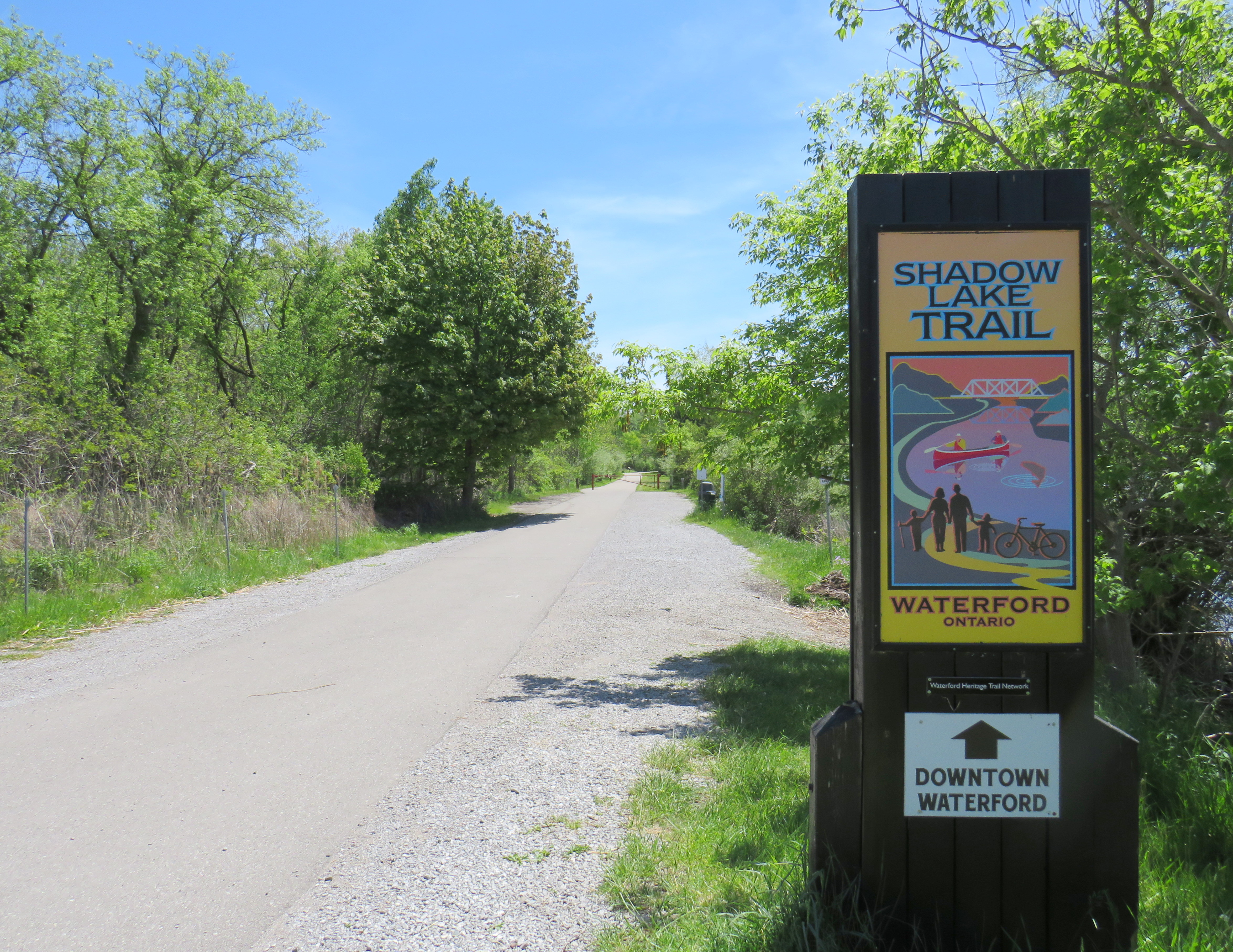
Take the Shadow Lake Trail to Downtown Waterford
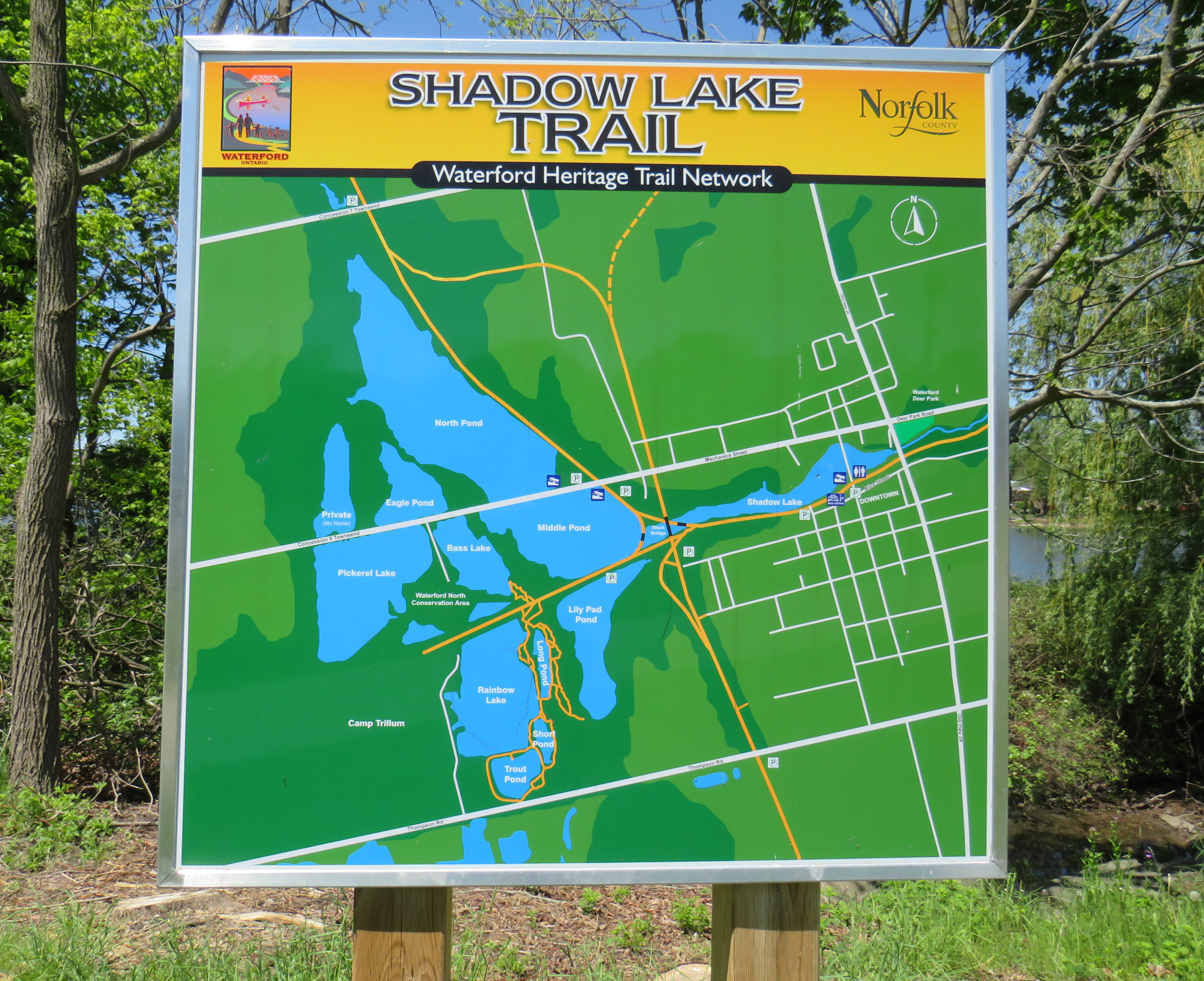
The large system of ponds around Waterford, popular with birds, boaters, and anglers, are artificial. Shadow Lake was a millpond created by damming Nanticoke Creek. When constructing its railway, CASO found the sand and gravel deposits in this area irresistible for exploitation; the gravel was first used for railway ballast; larger aggregate pits created new ponds to the west.
Map of the Shadow Lake Trailand connecting trails in Waterford, along with the extensive ponds surrounding them
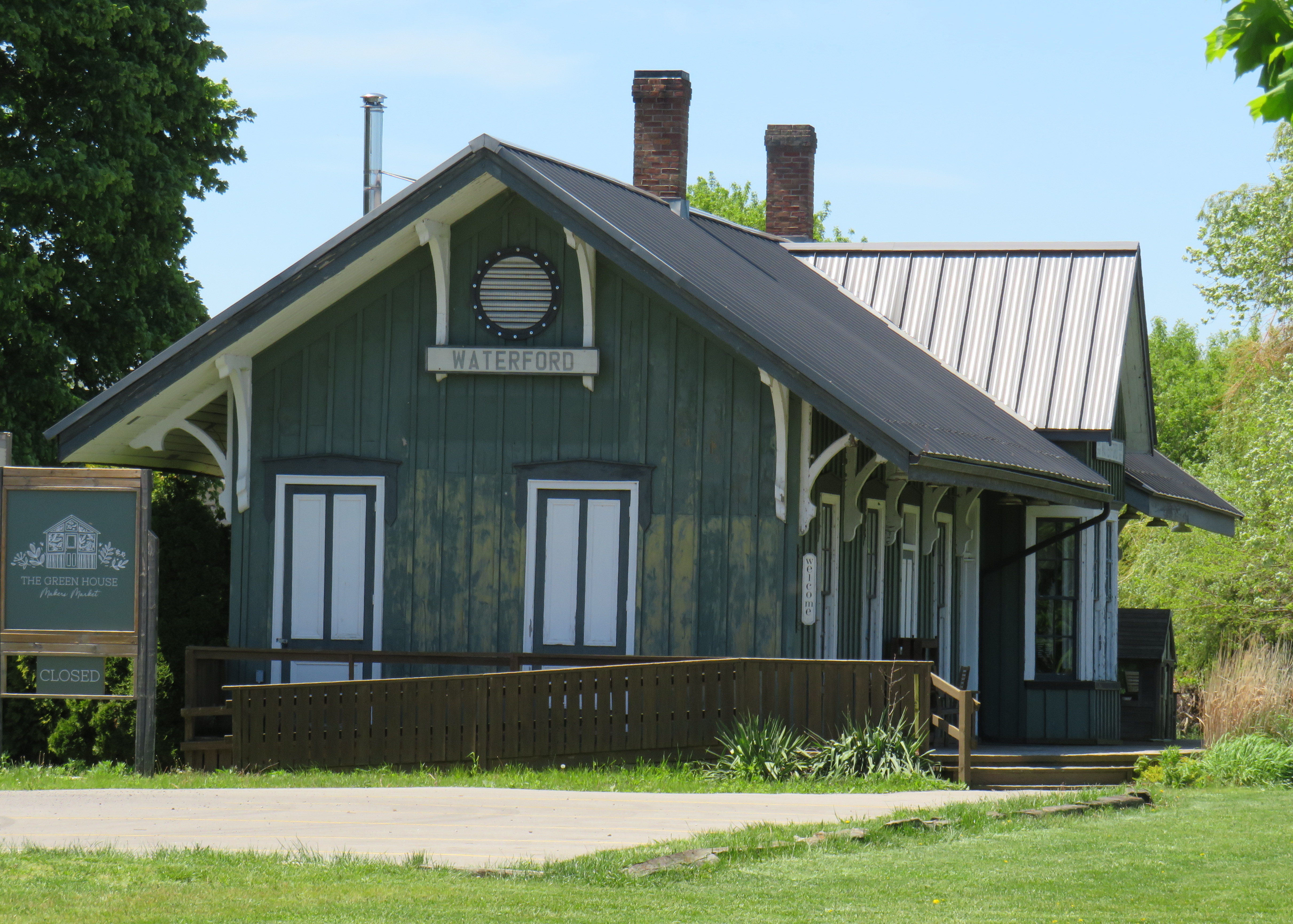
The former Canada Southern Railway Station, which also served the TH&B, still stands, and has recently been home to an artisan market. Sadly, the LE&N station was demolished in the 1970s.
Waterford CASO Station
Despite the loss of the railways and the LE&N station, the railway rights of way are fully intact within the village area and have been converted to trails. Within Waterford, the east-west Shadow Lake Trail follows the former CASO route between the Waterford Conservation Area to the west and Lingwood Park to the east, though it is not part of a continuous trail system across southwestern Ontario. Only short sections within Waterford, Tillsonburg, St. Thomas, and Essex are open to the public; most of the old railway corridor was sold off to local landowners in the late 1980s and early 1990s.
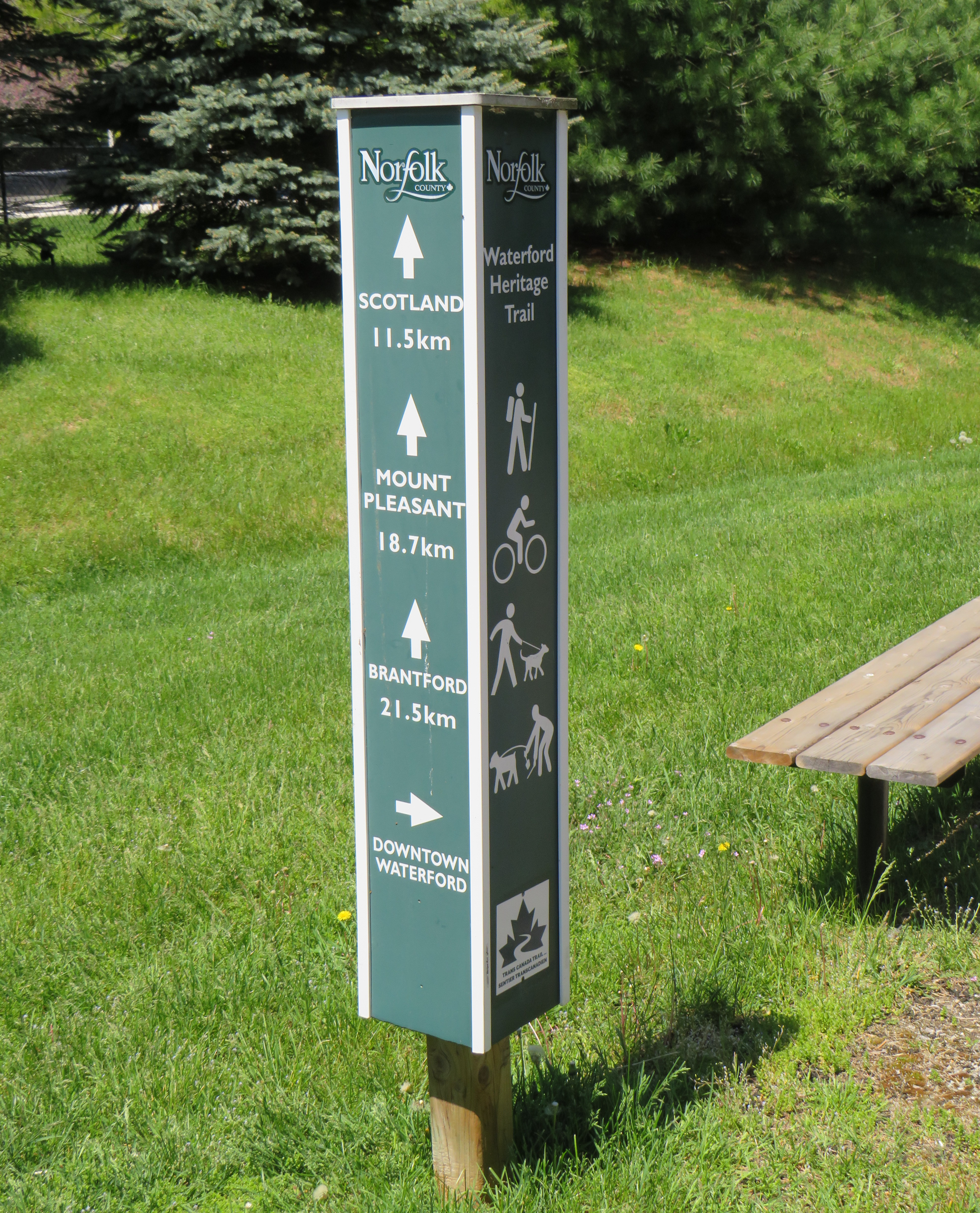
Norfolk County Trail sign
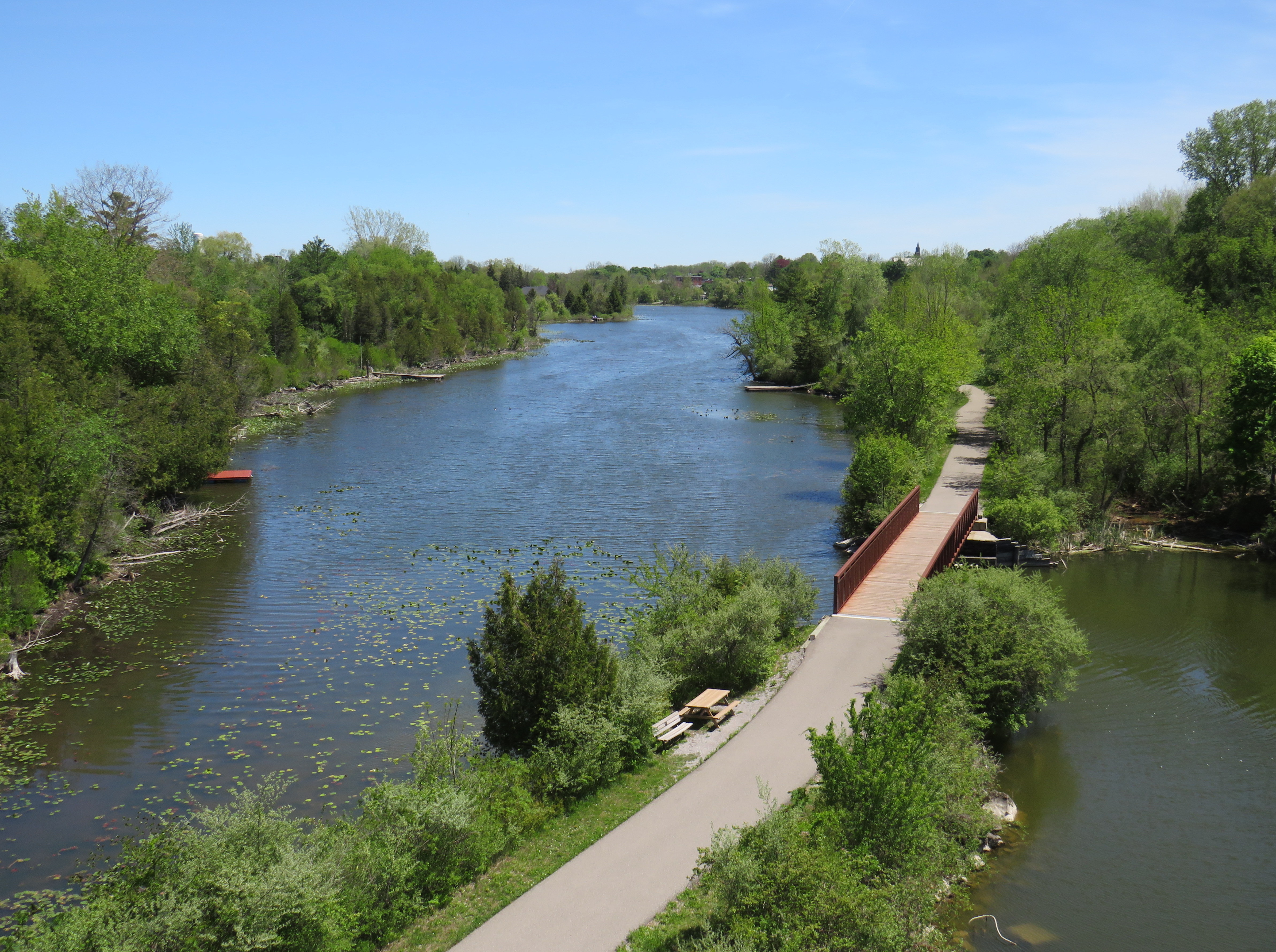
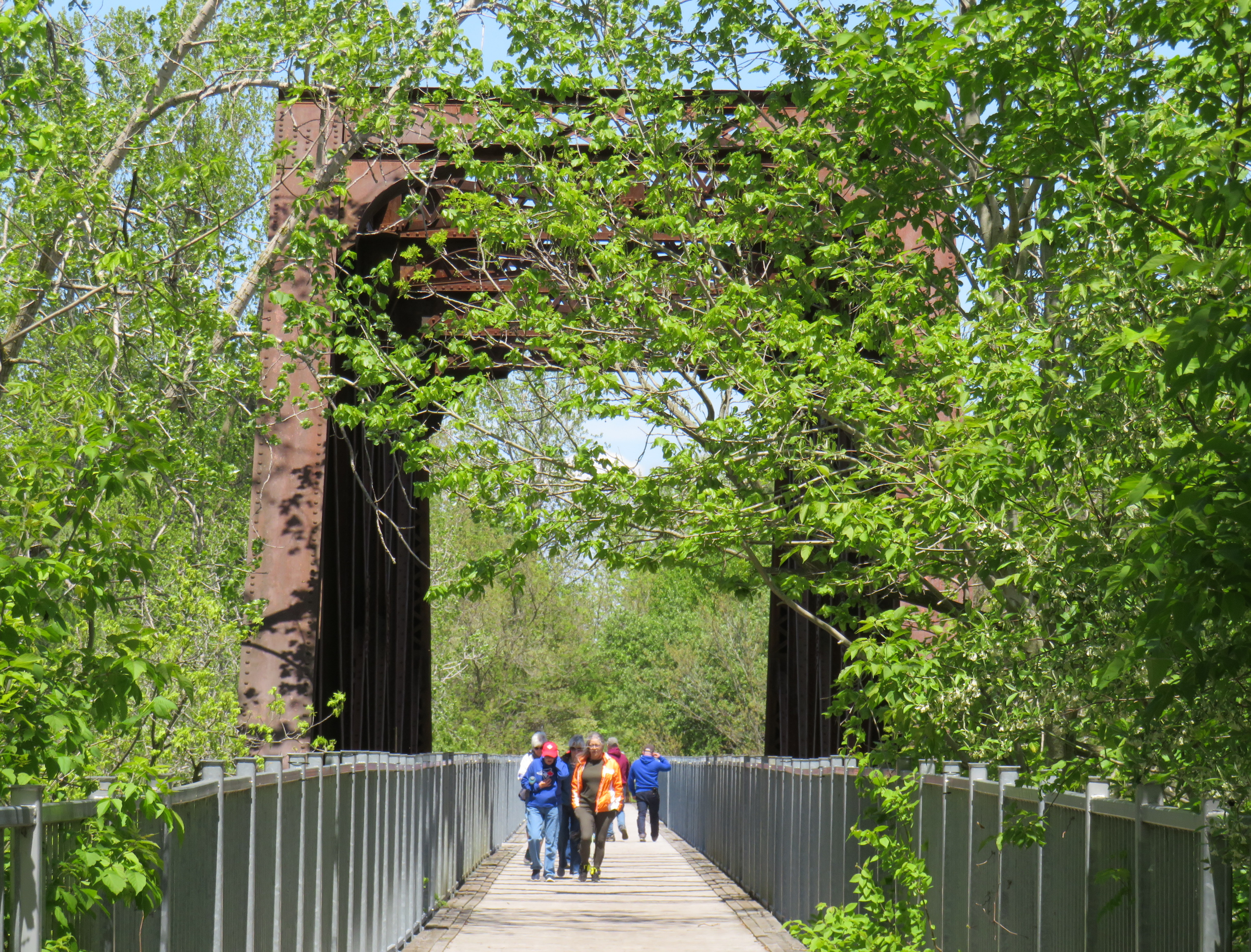
However, the north-south LE&N Trail, which connects to the Shadow Lake Trail by way of a gentle paved pathway or a metal staircase, is part of a much longer rail trail corridor that continues north to Brantford (the trail shifts to the TH&B route north of Waterford) and south to Simcoe and Port Dover. At Brantford, it is easy for the ambitious cyclist to continue east to Hamilton or north to Paris, Cambridge, and Kitchener via connecting high-quality rail trails. The Norfolk County Trail is at its scenic best when it crosses over the Waterford area via the Black Bridge.
The Black Bridge crosses over the old CSR and TH&B railways and the Waterford Ponds
One aspect that I especially appreciated was all the interpretive plaques along the trail system that told the story of Waterford, local industry, and the railways. This is how I learned that the ponds were the result of milling and quarrying, rather than truly natural features.
One of several interpretive plaques along the trail system in Waterford
Despite their attractiveness for long-distance cyclists, the trails within the Waterford area are well-used by residents and visitors going for shorter walks. The trail network within Waterford connects well to local streets and to itself by way of the former low-level TH&B wye tracks, which also cross the ponds. A walker can easily do a round trip without backtracking while being surrounded by nature. Wayfinding signage is very good, and benches are plentiful. The ponds are a great spot for bird watching. As we know how good walking is for our physical and mental health, Waterford is blessed with this network and could be a model for other smaller urban centres and rural communities.
In the early afternoon on a Thursday, the Black Bridge was popular with pedestrians and cyclists
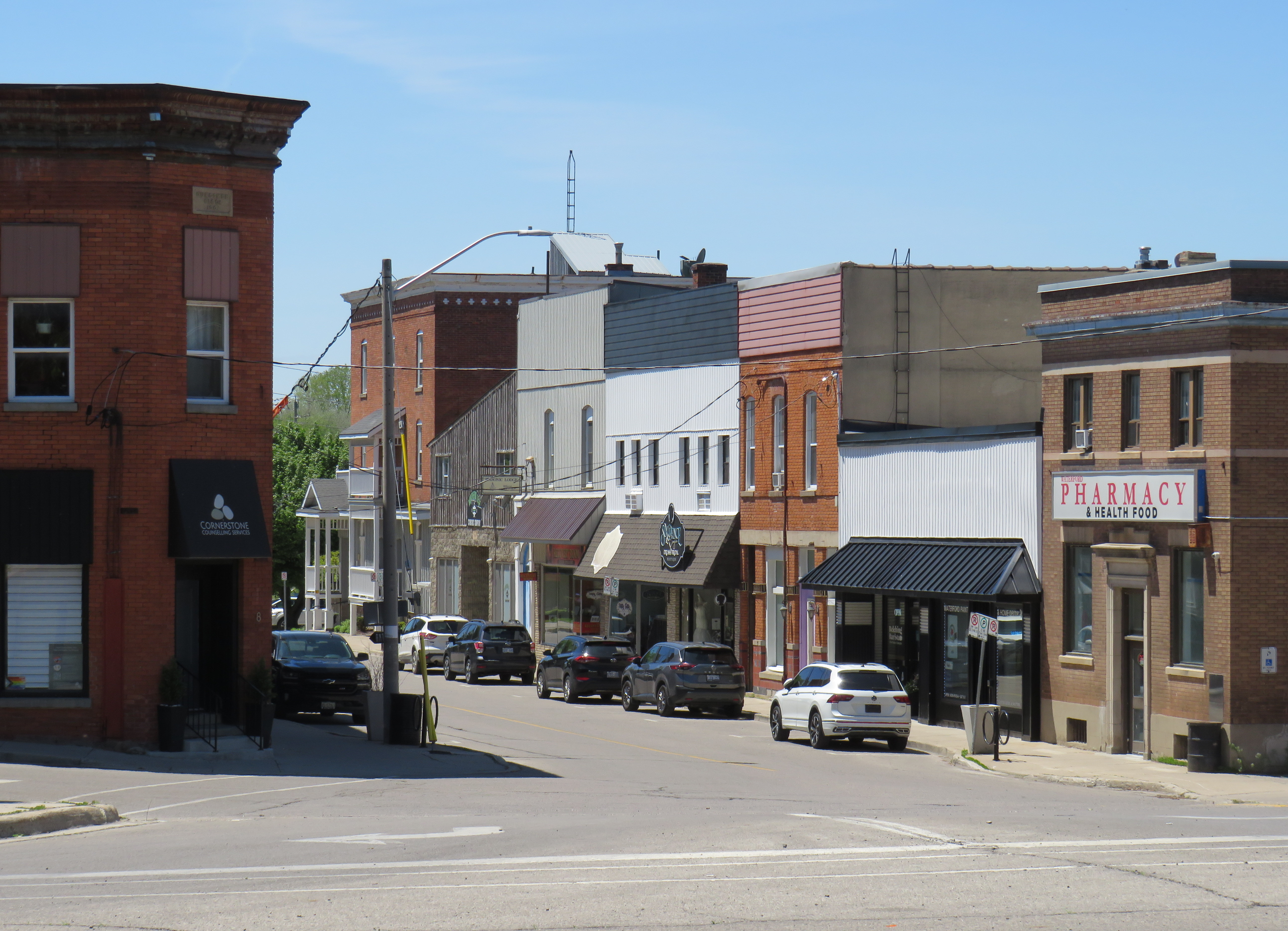
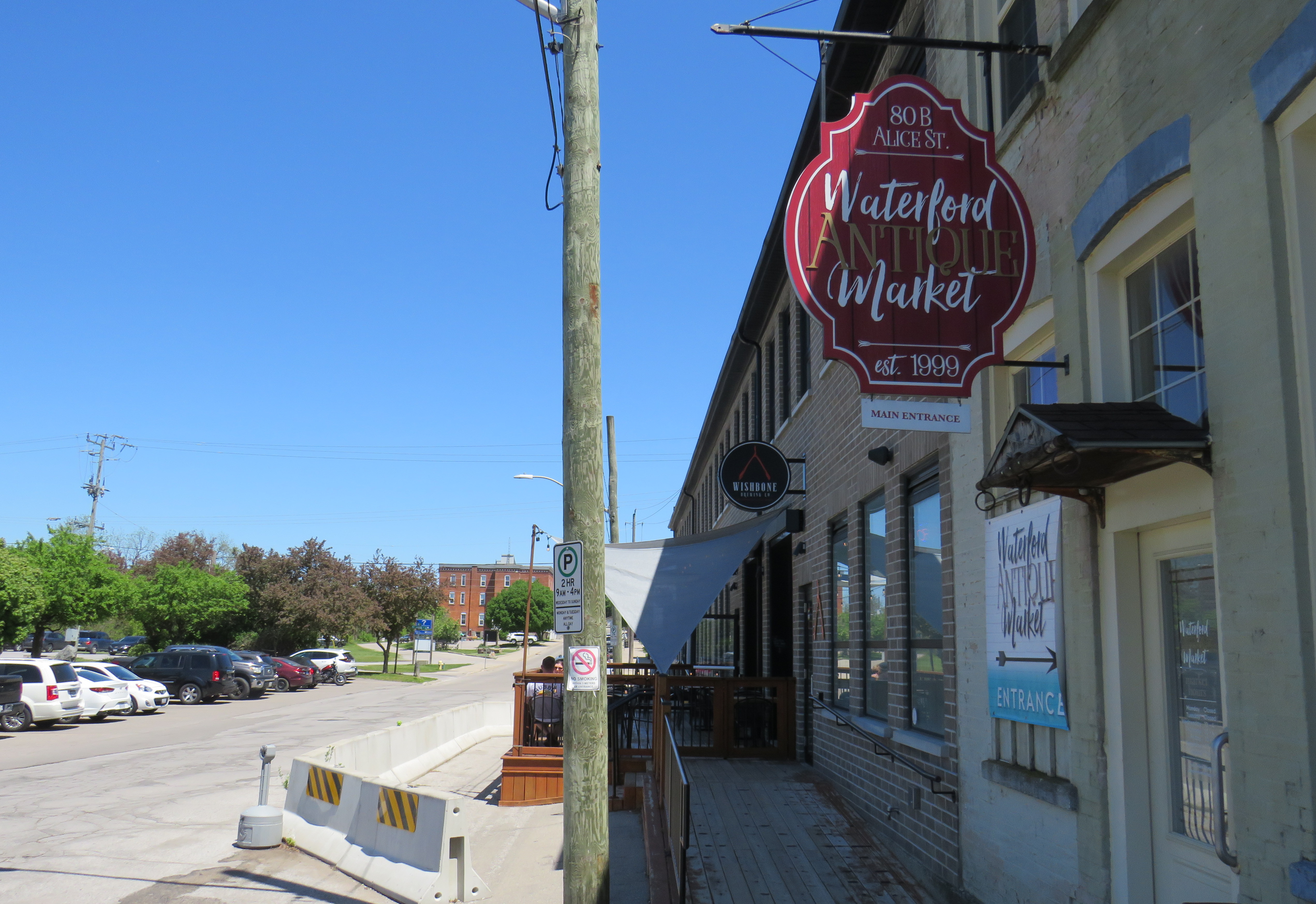
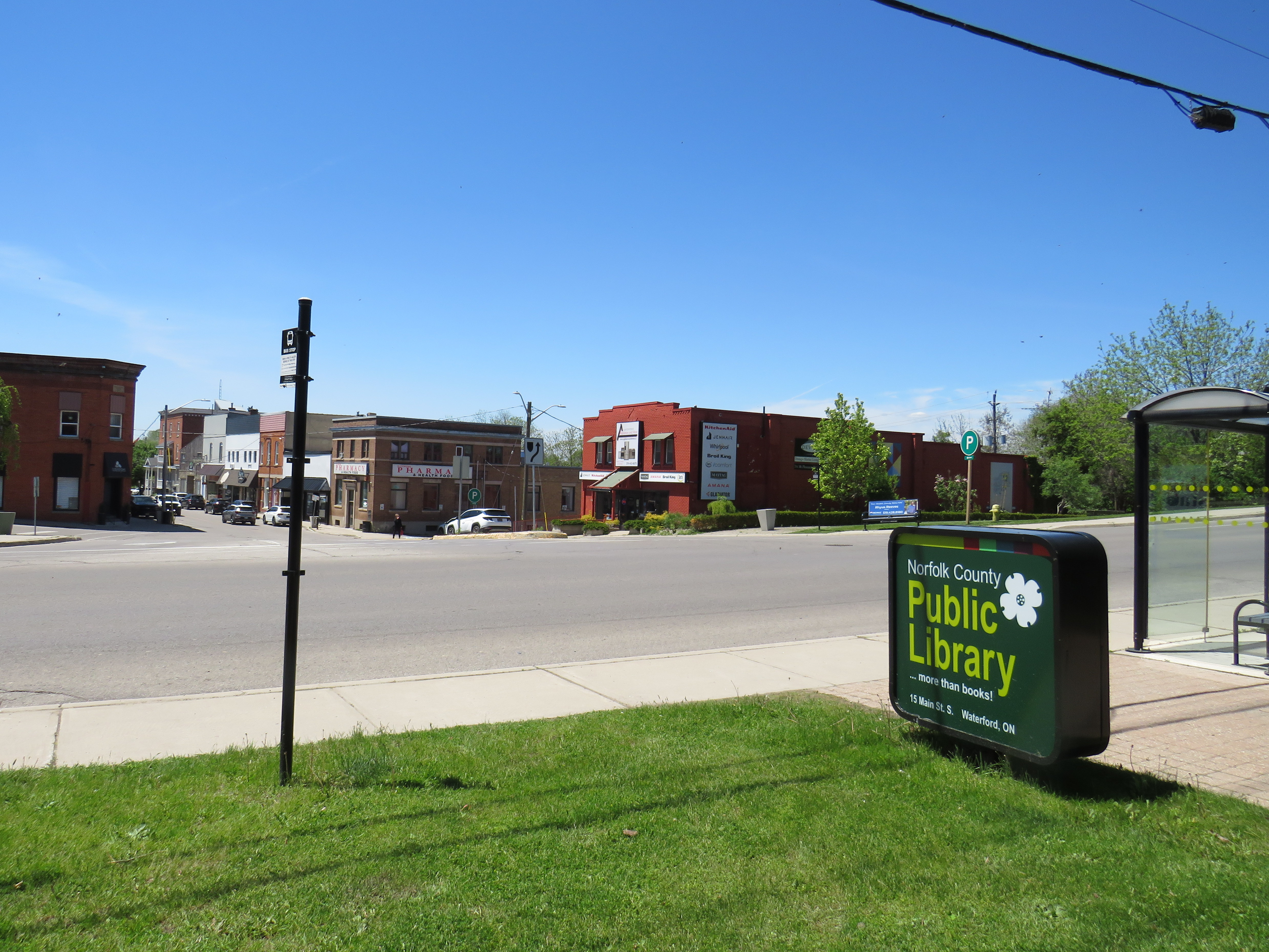
Within the little downtown, there are public washrooms for trail users as well as several restaurants, cafes, and a craft brewery located in a former textile plant. There are also several antique dealers, a public library, and other small shops.
Alice Street, Waterford’s main commercial strip, is lined with restaurants, shops, a cafe, and a breweryWaterford Antique Market and Wishbone Brewery, in a renovated textile plant
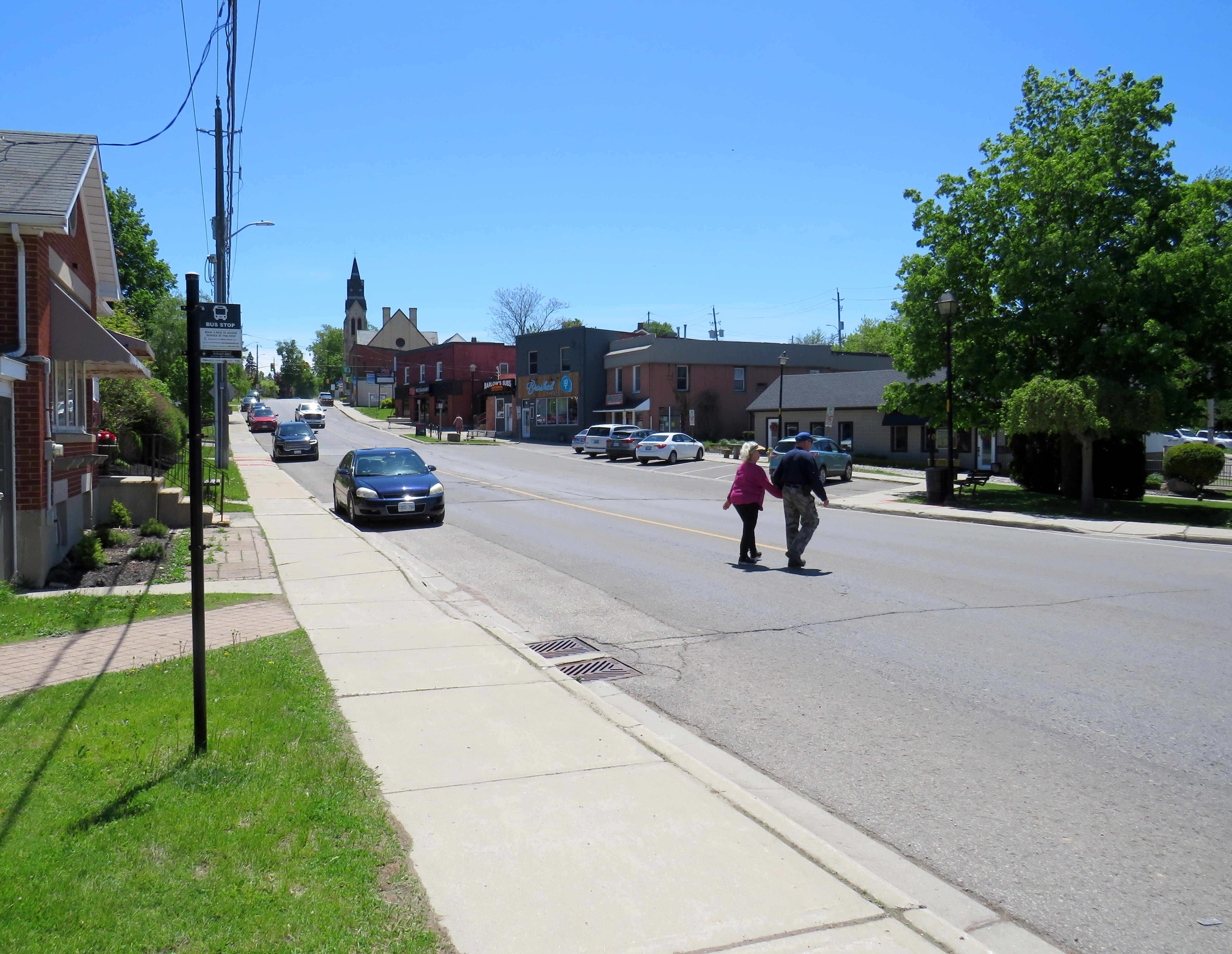
Despite all that Waterford has to offer, there is one thing that can be improved to make it safer to get around. Alice Street, the main commercial strip in Waterford, meets Old Highway 24 at an unsignalized crossing. Though busy Highway 24 now bypasses Waterford, the old highway is still busy, with drivers exceeding the 40 km/h posted speed limit. The Waterford library branch and northbound bus stop towards Brantford are on the opposite side of the wide T-intersection from the Alice Street businesses; it is surprising that there is no traffic signal here to control auto traffic and provide a safer pedestrian crossing.
The northbound bus stop (note the shelter at right) and library branch are on the opposite side of a busy road from the downtown shops
Though there is a traffic signal 200 metres to the south at Nichol Street, most pedestrians opt to cross at Alice Street instead. According to Google Streetview, there was a signed pedestrian crossing at Alice Street in 2009 but was removed by 2012.
Waterford is under a two hours’ drive from Downtown Toronto, though it is accessible without a car. GO Transit and VIA Rail both serve Downtown Brantford, where on weekdays, one can take a Ride Norfolk minibus south to Waterford. Cyclists from Hamilton or Toronto can take GO Transit buses to Brantford and bike south down the TH&B Rail Trail to Waterford on a relaxed 90-minute ride. From Simcoe, it’s an easy 45-minute ride.
In general, Ontario can do so much better promoting sustainable tourism and travel by way of transit, walking, and cycling, as there are many places like Waterford that are easy to get to and around without a car that are not especially well-known, and there are many opportunities to improve public and active transportation links to other communities throughout the province. Though some communities, like Brantford, Hamilton, and Peterborough are very well connected to multiple trail systems radiating outwards in multiple directions, other cities and towns are not so lucky.
Though St. Marys and St. Thomas, for instance, also have made great use of former rail infrastructure, they are lacking safe, high-quality active transportation connections to nearby cities like London or Stratford. Lindsay, in Kawartha Lakes, is at the nexus of several trails as well, but it lacks any intercity bus connections of its own. A provincial strategy could go a long way.
Hurontario Street, looking south from Steeles Avenue, where the first phase of the Hurontario LRT will terminate
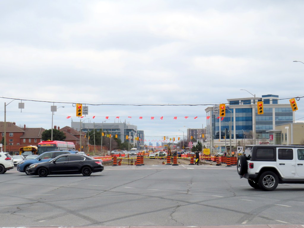
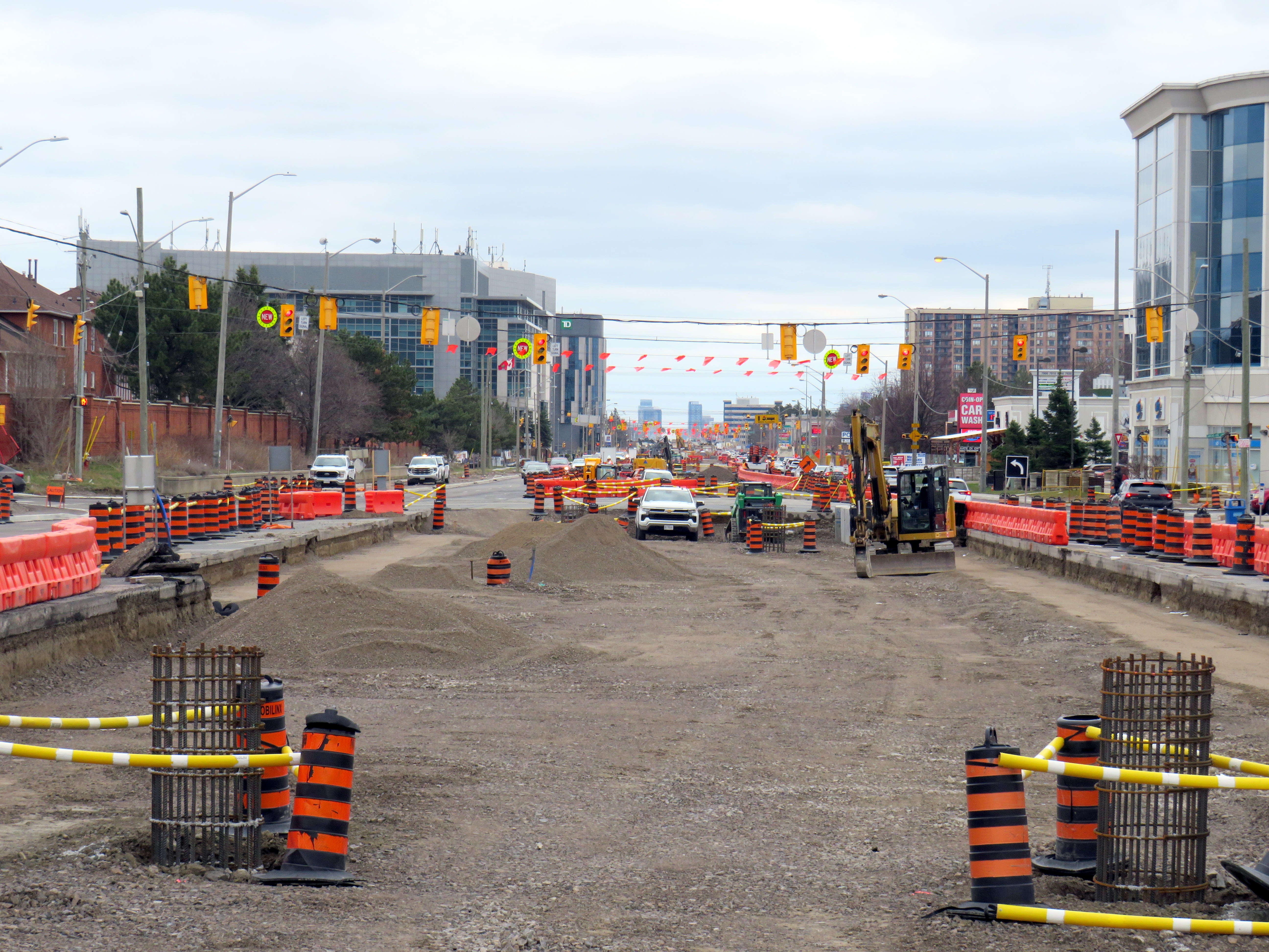
The first phase of the Hurontario LRT, which will between Port Credit GO Station and Steeles Avenue in Brampton, is slowly taking shape after years of construction delays. In Spring 2026, eight years since construction started on the corridor, work on the LRT guideway into south Brampton has finally begun.
As I wrote in detail before, a previous iteration of Brampton City Council narrowly voted against the LRT entering downtown as a surface line in 2015. This was the version selected in the provincial environmental assessment. Instead, that council voted to study alternative corridors into Downtown Brampton requiring lengthy detours, and asking for the LRT northern terminus to be on the south side of Steeles Avenue, despite a major bus exchange — Brampton Gateway Terminal — on the north side of the intersection to accommodate all options. After the 2018 election, council recommitted to a Main Street alignment (though preferring a tunnel) and asked the province to restore the terminus on the north side of Steeles pending a decision on the final four kilometres into Downtown Brampton. In early 2026, only one of the six councillors opposed to the Main Street LRT ten years ago remains in office.
I wanted to follow up with Metrolinx to see how pedestrians would be safely accommodated at the Steeles and Hurontario intersection, given high traffic volumes, wide roads, and likely thousands of passengers switching between modes on a daily basis. Early concepts of an underground pedestrian tunnel were rejected by the province as out-of-scope, so pedestrians would have to cross both Hurontario and Steeles to make the transfer. Having no satisfactory answers despite many attempts to get an answer to this question, I took the lengthy and expensive route of submitting a freedom of information (FOI) request.
In summary, I learned that despite multiple requests from City of Brampton officials to restore the north side stop, Metrolinx and the provincial government refused. With the financial close with Mobilinx — the private-sector consortium selected to build, operate, and maintain the LRT — imminent in early 2019, there was no interest to make the minor change to facilitate the terminal, even though the city committed to taking on the cost on its own. The province was open to other changes to the line, however, as in 2022, it unilaterally renamed the line for a former Mississauga mayor and political ally of Doug Ford.
Looking south across Hurontario Street across a very busy multi-lane intersection towards the end of the LRT
As work at the Steeles-Hurontario intersection is now well underway, it has become visually clear the problem will be once the LRT opens. The population around the Brampton Gateway Terminal area is rapidly growing; a 40-storey condominium tower on nearby Steeles Avenue West is nearing completion, with many more highrise and mixed-use developments planned, including the eventual redevelopment of Shoppers World Mall. Already, there are dozens who cross nine-lane Steeles Avenue hourly; once passengers have to transfer from the LRT to the transit terminal on the northwest corner, there will be hundreds.
Furthermore, once the (now-funded) Phase 2 of the LRT to Downtown Brampton is started, the intersection will have to be torn up yet again to extend the tracks across Steeles and build a new north-side stop. The province’s refusal to do this all at once is baffling, and will likely be much more expensive than if it was done right the first time.
Looking across from Gateway Terminal towards the future LRT terminus on Wednesday, May 6. Already, there are plenty of pedestrians crossing here.
Already, the costs of the current Mobilinx contract have ballooned while construction delays pile up. The Hurontario LRT was originally supposed to open in 2024. In 2025, Mobilinx had to completely rebuild the track intersection at Topflight Drive just south of Highway 407 after track was already laid in 2023 due to construction errors. In February 2026, Global News reported that only 45 percent of the track was laid. Due to delays and problems paying contractors, the consortium’s credit rating was downgraded by Standard & Poor to BBB, which is near junk status.
Given the multiple delays and difficulties building the LRT, work is only now at the point where the dangerous terminal location is being baked in. Even though construction errors are fixed, and the project name changed, Metrolinx has been unwilling to address the safety issue at Steeles Avenue that was raised many times. In the meantime, Metrolinx, Peel Region, and City of Brampton will have to figure out how to mitigate the potential disaster that is now in the making.
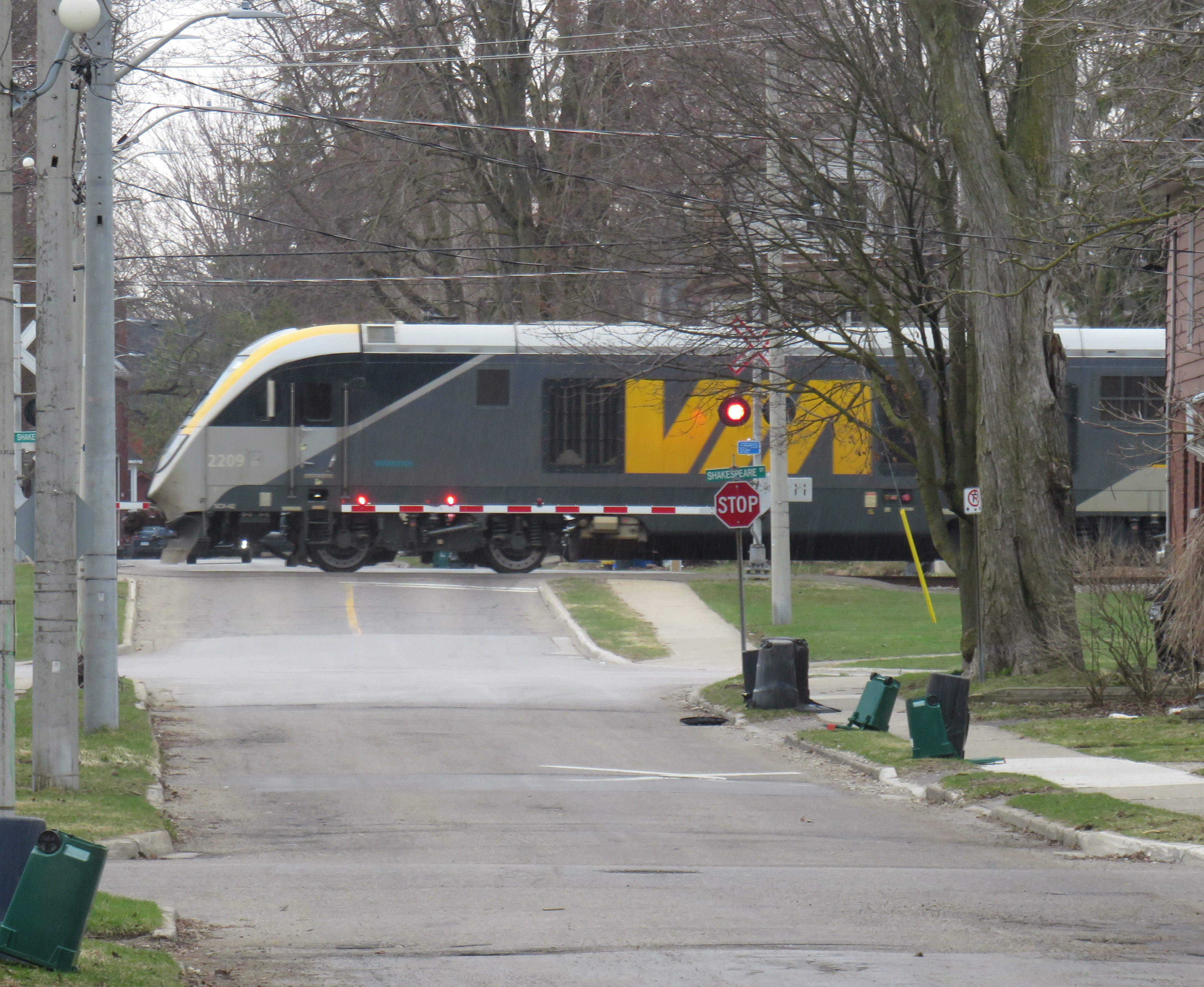
Slow orders at CN railway crossings are not the only slowdowns encountered by VIA trains
On the way home from a meeting I had in Ottawa on Sunday, May 3, I was aboard VIA Train 647, which left Ottawa Station at 4:51 PM. Our train was held up twice in the first hour: once at Smiths Falls, where we had to wait just under ten minutes for a CPKC freight train to pass, and again at Jasper, where we sat on a siding for about five minutes for an Ottawa-bound train to pass. As a result, our train arrived in Kingston at 7:10 PM, 15 minutes later than scheduled.
VIA Rail owns the track north of Brockville, where Toronto-Ottawa trains verge off the CN mainline between Toronto and Montreal, though it still has to cross the CPKC mainline at Smiths Falls through a freight yard there. Around 2010, after VIA took over the track from Canadian Pacific (once part of a line from Brockville to the Ottawa River near Arnprior), it built new passing sidings and moved the Smiths Falls station stop away from the old CP station to increase passenger train capacity and reduce conflicts. Ideally, the VIA and CPKC tracks would be completely separated, but it would be very expensive to implement.
Despite CN restrictions on VIA’s Venture equipment, with mandated reduced speeds at level crossings, we lost only ten more minutes upon arrival at Oshawa, getting there at 9:01 PM instead of the scheduled time of 8:36. But we had yet to encounter one last obstruction: Metrolinx-owned track between Pickering and Toronto Union Station.
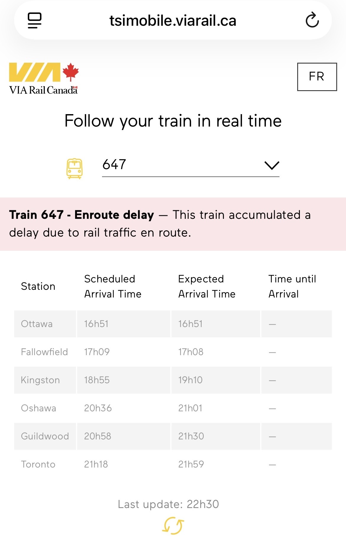
Where the CN Kingston Sub meets the GO corridor west of Pickering Station, our train once again came to a stop for about five minutes. We were held behind a westbound GO Lakeshore East train, slowed down by its regular stop at Rouge Hill. Once we got moving again, our train stopped briefly at Guildwood to allow a few passengers to get off, and now we were 28 minutes late on the VIA train.
From Guildwood westward, the Lakeshore East corridor is triple tracked, so we were able to pass the westbound GO train as it made stops at Eglinton, Scarborough, and Danforth. But under the Main Street bridge, we stopped once again; two minutes later the GO train started moving slowly beside us, taking the lead. With the corridor down to two tracks between Woodbine Avenue and the Don River for Ontario Line work and track expansion, Metrolinx dispatchers decided it was worth holding back a VIA train that would have cleared the section quickly if we were permitted to proceed past Main Street, so that a GO train would have priority and not wait one minute or two despite that train being on time.
View from a stopped VIA train as a GO train picks up speed after stopping at Danforth Station
We finally arrived at Union at 9:59 PM, 41 minutes late. Sadly, this is a very common occurrence, particularly with inbound trains to Toronto.
Though CN gets plenty of blame for slowing down VIA Rail passenger trains by prioritizing its freight operations and its level crossing spat, Metrolinx must wear some of the blame for VIA’s woes. It is worth pointing out that nearly all VIA passengers affected by poor train dispatching are travelling to or from destinations served by GO Transit: Toronto, Oakville, Oshawa, Aldershot, Brampton, and the majority are travelling within Ontario, including cities such as London, Ottawa, and Kingston. As an agency of the province, Metrolinx should support Ontarians travelling on trains within Ontario, even if they are not aboard Metrolinx-operated GO trains.
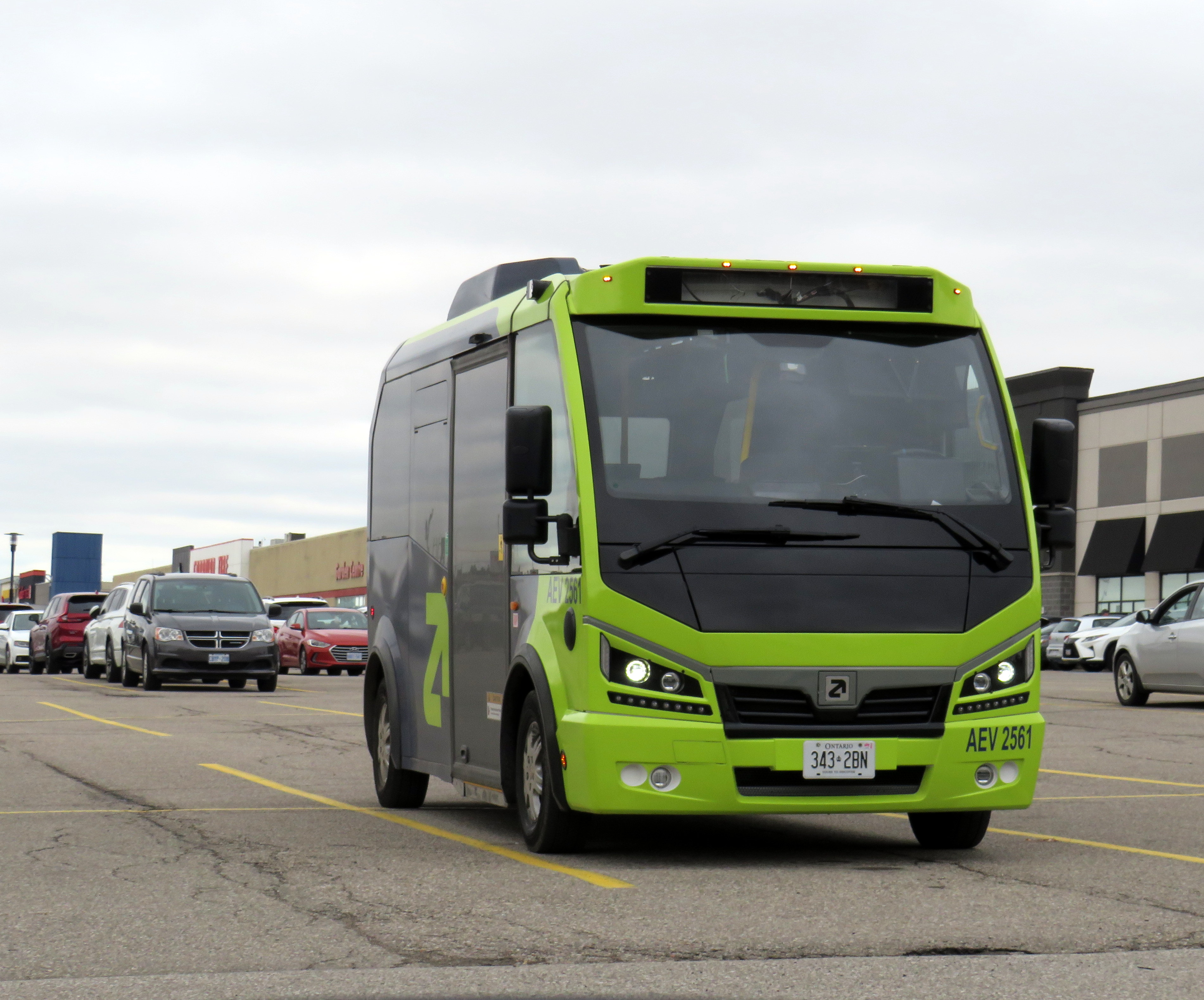
An Argo minibus lays over at Shoppers World Brampton
In an interesting staff report presented to Caledon Town Council, that municipality is planning to enter into a 15-month On-Demand Micro-Transit Pilot Agreement with Argo Transit, a Brampton-based provider of electric minibus services. This new on-demand transit service would replace most of the contracted Brampton Transit services in the Town of Caledon, including Routes 41, which serves Bolton, and 81, which runs along Kennedy Road north of Mayfield Road. Extensions of Route 30 Airport Road and 18 Dixie would continue under Brampton Transit, as they are limited-service extensions directly serving specific employers.
Argo already provides on-demand service in Bradford-West Gwillimbury, replacing a fixed-route service there last year It also operates a supplemental door-to-door on-demand service in central Brampton on top of the fixed route Brampton Transit service. In Brampton, and as expected in Caledon, the same fares at Brampton’s regular service are charged, paid through a Presto card or app.
The benefits for Caledon include new service to and within Caledon East, which is currently without transit, as well as midday, early evening, and weekend service not currently provided through Caledon’s contract with Brampton Transit. The proposed service times will be Monday to Friday from 5:30 AM to 8:00 PM, and Saturday and Sunday from 7:00 AM to 7:00 PM. If implemented, Argo service would begin October 1, 2026.
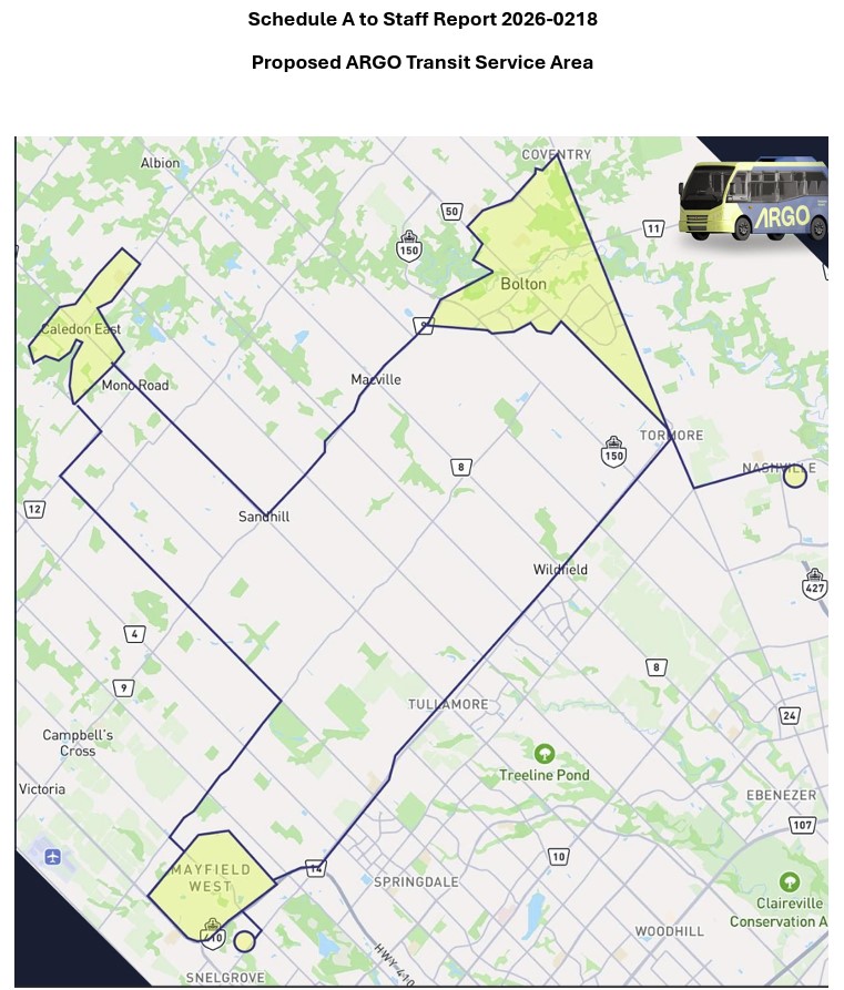
The map, included as an appendix to the staff report, shows connections to Brampton Transit on Mayfield Road and to York Region Transit in Kleinburg.
Map of proposed Argo service areas in Caledon, with connecting links.
There are some questions that should be addressed before October. Currently, Route 41 provides service to employment areas in south Bolton and provides connections to several Brampton Transit and YRT routes at Highway 50 and Queen Street, with easy transfers to the TTC subway in Vaughan and Humber College in Etobicoke. Would Brampton maintain a shortened route to Mayfield Road and Highway 50 that could make this link? Would transfers be permitted to other Brampton Transit routes along Mayfield Road, including Routes 15, 18, and 30, or would stops outside the on-demand areas be restricted to those in the map?
For Caledon, on-demand transit looks like an attractive option to replace Brampton Transit-contracted routes with low ridership and limited service hours. For it to succeed — and even build ridership for new fixed-route service in the future — connections to other transit will be necessary.
Despite population growth, Brampton Transit ridership is in decline
Meanwhile, Brampton Transit, after several years of dramatic ridership growth after the end of COVID-19 restrictions, is cutting back as ridership has taken a sudden dip in 2025-2026. Four minor routes — 33 Peter Robertson, 36 Gardenbrooke, 55 Elbern Markell and 56 Kingknoll — will be discontinued. These four neighbourbood routes provide local service in areas where other routes are within walking distance or operate in the opposite direction, so the effects are minor and the cuts justifiable if it keeps service going elsewhere.
However, Route 5 Bovaird, a major local route between Westwood Mall and Mount Pleasant GO Station, will see significant cuts: in the weekday peak from 13 minutes to 20 minutes and evenings from 30 to 40 minutes, and weekend evenings from every 30 to 50 minutes. The 505 Zum route that parallels the 5 does not operate weekend evenings, resulting in very poor service along the Bovaird corridor during those times.
This is a disappointing setback for transit in my hometown, which up to now has been a model for promoting ridership growth in a suburban edge city. For years, I have wrote about its success in growing demand by operating good service, especially to destinations well beyond its boundaries to places like York University (later the subway terminal in Vaughan), Mississauga City Centre, Humber College, and Pearson International Airport.
It would be very unfortunate if transit were allowed to enter a “death spiral” of ridership decline, fare hikes, and service cuts in response to this dip, largely due to a decline in international student enrollment at colleges and universities. Brampton has shown before that good service, with incremental growth is a great way of boosting ridership. This means operating buses at least every 20-30 minutes at all times on major corridors like Bovaird.
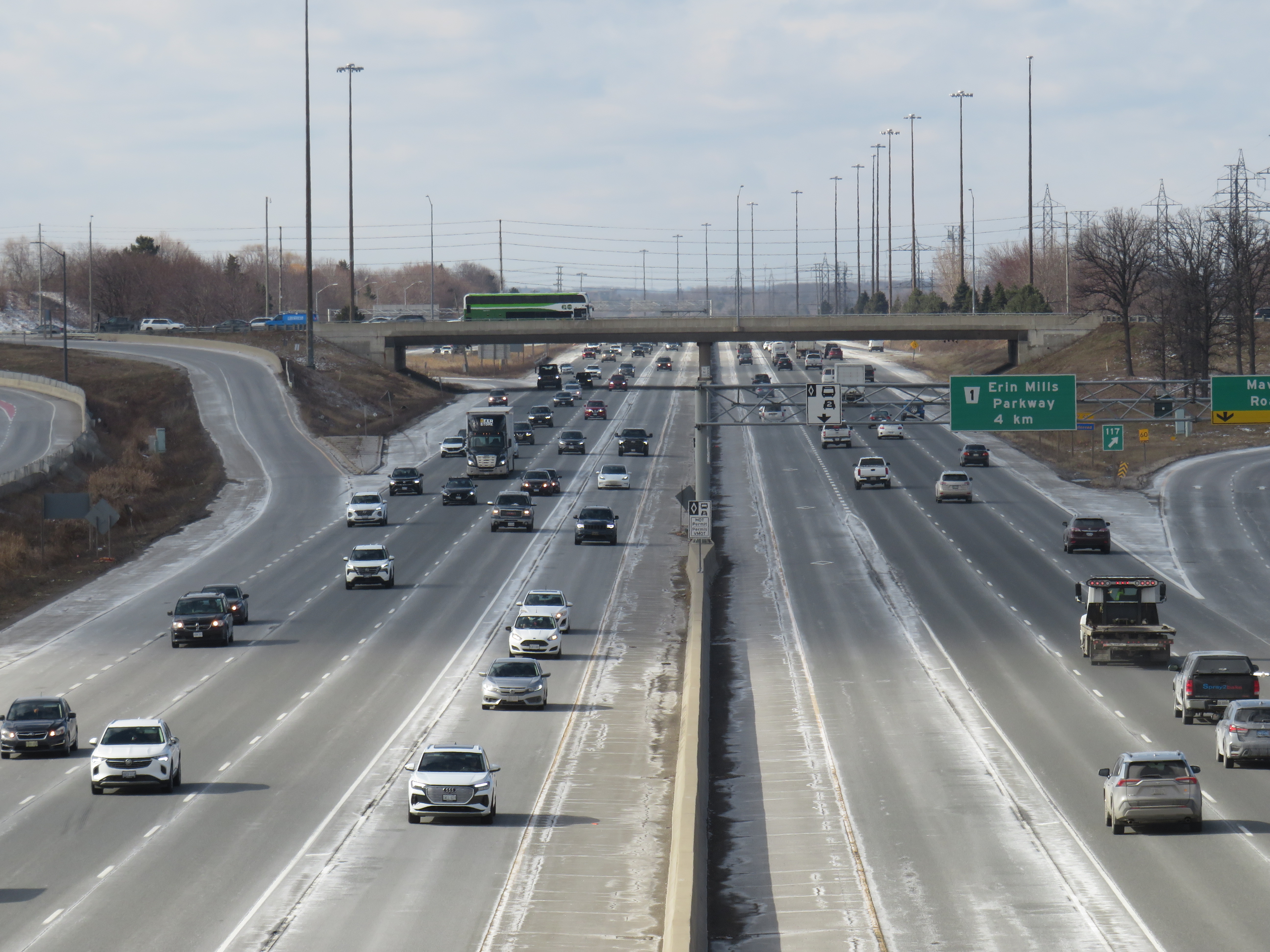
Highway 403 in Mississauga, with HOV lanes in the centre
In the last year, making the occasional car trip to visit family in Northeastern Ontario or just to get out of the city for a day or two, I kept wondering what the point of those new high occupancy vehicle (HOV) lanes were on the Queen Elizabeth Way, Highway 400, or Highway 401. At first, they seemed like a real time saver for anyone riding on a transit bus or driving with a few family members, friends, or carpool colleagues in the car. As time went on, with new exceptions, minimal or no police enforcement, and increasingly aggressive driving post-pandemic, one is left wondering why the province even bothers adding them to more highways.
Now, amongst a flood of moves and musings by our oft-Trumpian premier, it appears that the province has given up on even the veneer of sustainability with these highway widenings throughout the Greater Golden Horseshoe and Ottawa regions. On Tuesday, March 17 — St. Patrick’s Day — Transportation Minister Prabmeet Sarkaria announced a proposed regulatory amendment that would allow all cars and light trucks in the HOV lanes, during off-peak periods. The change would “help keep drivers moving across the province, so they can spend less time in traffic and more time with their families and friends.”
This announcement is part of a stream of messages from Doug Ford and his government clearly seeking the attention of the news media and the public. The week prior, Ford was talking about expanding the Toronto Island airport, even seizing control of the City of Toronto’s interest to ensure that jets could land on the waterfront. Before that, Ford mused about a new convention centre built on Lake Ontario near Exhibition Place. This week, Ford was on a law-and-order kick, attacking a fair and impartial judiciary, promoting the idea of “Bail TV,” and praising a homeowner that shot an intruder during a home invasion. Maybe this is to distract from scandal and a new proposed law to shield the premier, ministers, and staff from journalists using freedom of information requests to keep the government accountable.
The legislative assembly will finally reconvene next week, starting Monday, March 23, after a 14-week break.
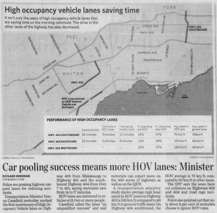
The first HOV lanes were introduced on Highway 403 through Mississauga and on Highway 404 southbound from Highway 7 to Highway 401/Don Valley Parkway in 2005. A year later, the HOV lanes were touted as an “unqualified success,” with the minister of transportation at the time, Liberal Donna Cansfield, promising more reserved lanes to follow, with the QEW through Oakville and Burlington to be the next implementation. With the Ontario Provincial Police (OPP) conducting active enforcement on those two sections, they found that only 5 percent of motorists in the HOV lanes were violating the law.
GO Transit was an especially keen user of the new HOV lanes. In 2005, only the Lakeshore Line had regular off-peak train service, and buses filled in the gaps in between. The 404 lanes saved valuable minutes for buses on the 70/71 Stouffville Line route between Union Station and Markham; the City of Toronto designated sections of the inner paved median on the DVP as well for GO buses that could be used to bypass traffic congestion.
Clip from the Toronto Star on Thursday, Dec 14, 2006
At the time, the HOV lanes saved carpoolers and transit riders up to 17 minutes on the initial segments on Highways 403 and 404. The additional capacity created with the new lane (no existing lanes were to be converted to HOV-only under provincial policy) also led to time savings for all drivers, at least in the short term. Increased traffic caused by suburban growth and induced demand eventually negated those time savings for general traffic.
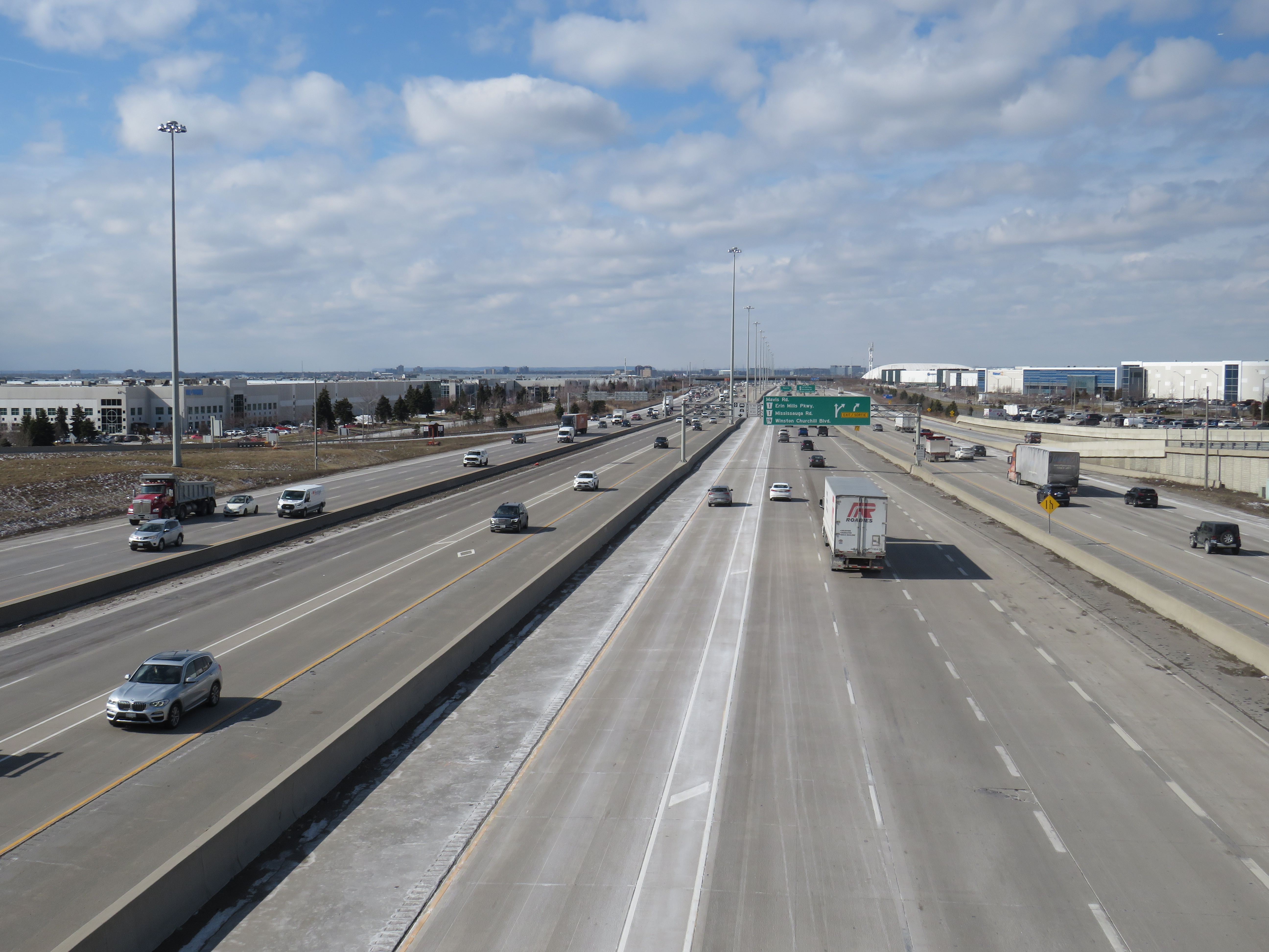
HOV lanes were included in more highway expansion projects. The QEW HOV lanes through Oakville and Burlington were added in 2011. Lanes on Highways 400, 410, and 427 and Highway 417 in Ottawa followed, and when Highway 401’s express/collector system was expanded through western Mississauga and Milton, HOV lanes were part of that too.
“One more lane should do it,” Highway 401 in Mississauga, with HOV lanes in the middle of a recently widened highway
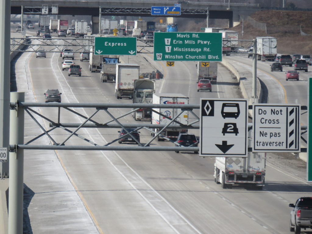
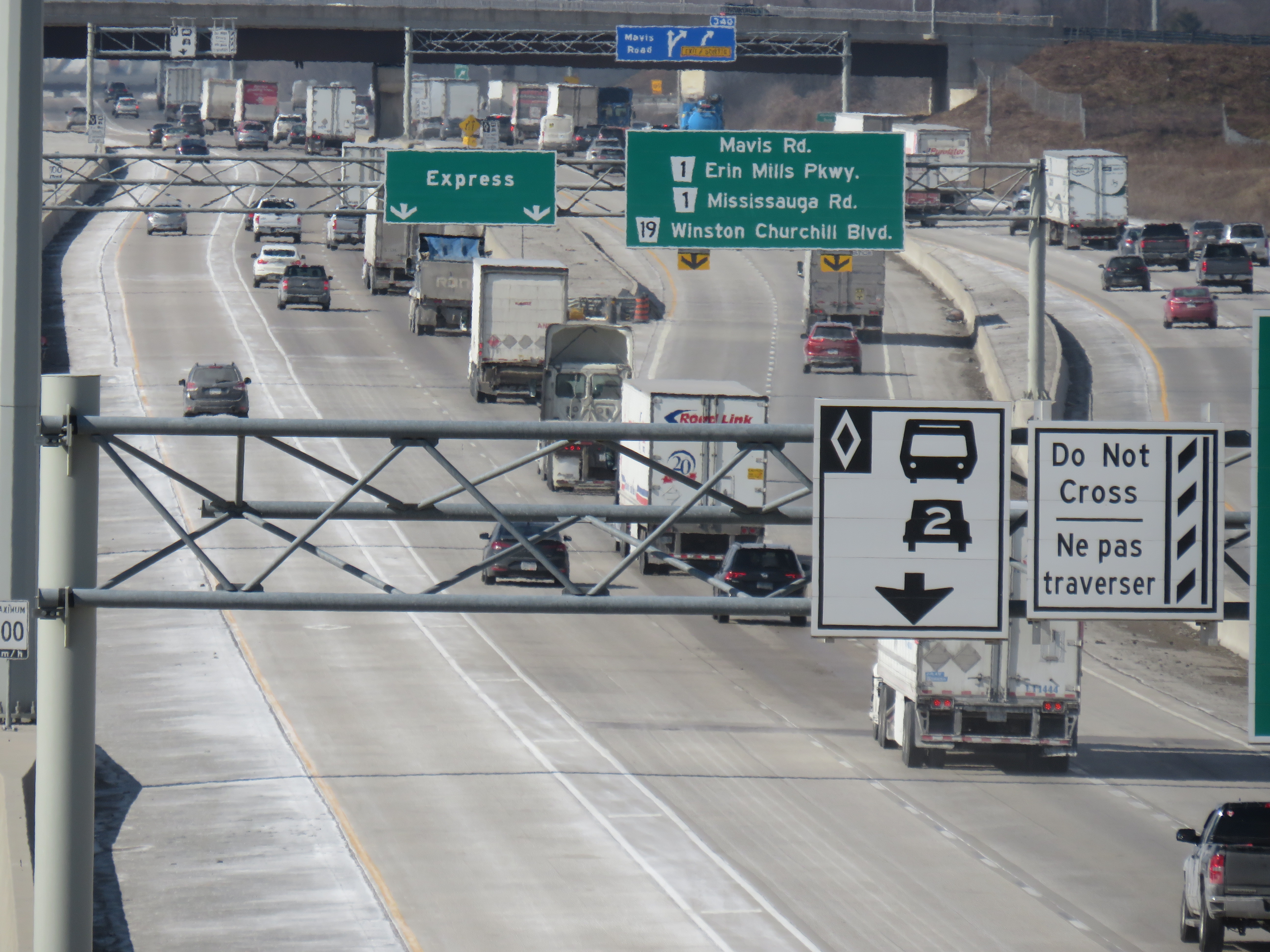
Regulations on the use of HOV lanes were relaxed over the years too. Motorcyclists were permitted, as were any vehicle with a “green” license plate (available to any battery-electric or plug-in hybrid car, SUV, or light truck). HOT permits were also added, for anyone willing to pay and enter a lottery for the right to use the lanes while driving alone. Taxis and airport limos were also allowed, even when not carrying a passenger.
Poor driving habits, which seemed to have gotten worse since the COVID-19 pandemic, have made a mockery of the initial intentions of the HOV lanes. Without enforcement, the HOV lanes are essentially treated by some drivers as fast lanes, with sudden swerving in and out despite double solid lines and “Do Not Cross” signs consistently posted along the highway, intended to reduce weaving. Solo drivers regularly use the lanes without consequence to get around slower drivers or trucks.
Despite “Do Not Cross” signs, and a double solid line between the HOV lane and general traffic, this regulation is regularly ignored
For now, we do not know what “off-peak hours” would mean when the provincial government finally legalizes another bit of the selfish and aggressive driving behaviour the rest of us have sadly gotten accustomed to. The QEW is frequently jammed most weekends between May and October, when families and tourists travel between Toronto, Hamilton, and Niagara. Highway 400 is notorious on Friday evenings and Sunday afternoons during Cottage Country commutes.
This is yet another motorist-friendly move by this government eager to hold onto seats in suburban ridings and please its wealthy backers, along with permanent gas tax breaks, abandonment of license plate renewal fees, the prohibition on speed enforcement cameras, and the construction of destructive new highways like the 413. But at least this latest move is an acknowledgement of something I have felt for years about the HOV lanes in Ontario: a simple greenwashing of highway expansion, making us feel better about laying more concrete and asphalt.
Once again, Doug Ford wants to mess with local democracy. This time, it’s in Niagara Region.
With the recent news overload — yet another war in the Middle East, rising fuel costs, another municipal mayoral race — not to mention the flood of news from Queen’s Park (a new mega-convention centre on Lake Ontario, moves to let bigger passenger jets on an expanded island airport, and legislation to increase secrecy within the highest levels of provincial government), you might be forgiven for missing yet another bit of news.
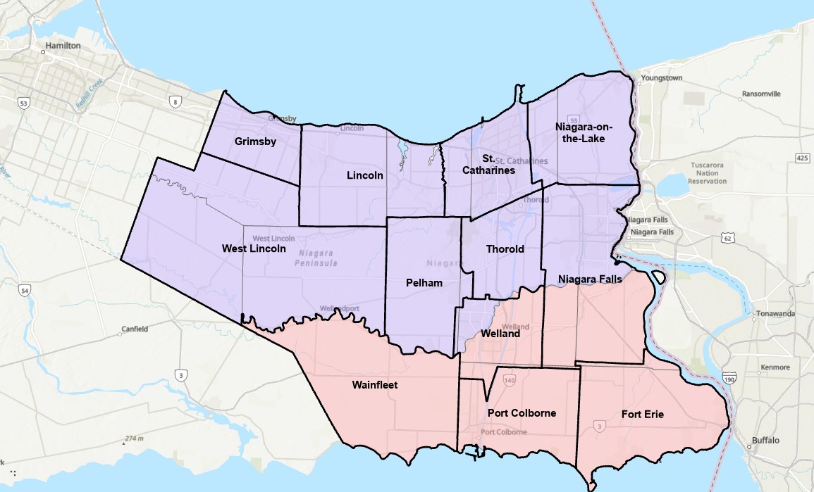
Niagara Region municipalities, with former Lincoln County townships in blue and Welland County townships in red
Niagara Region is one of eight regional governments in Ontario, a specialized level of government introduced by an earlier Progressive Conservative government in the 1970s, following on the success of Metropolitan Toronto created in 1954. Regional governments had more powers and responsibilities than counties, including regional planning and the provision of water and wastewater systems deemed essential for smart urban growth. Most regions formed their own police services, and many took on responsibility for household waste management and public transit (Durham, Waterloo, York, and most recently Niagara). Other services, such as fire departments, libraries, local planning, parks and recreation, and local public works remained the responsibility of the cities, towns, and townships.
The Mike Harris-led PC government, elected in 1995, was a big proponent of municipal amalgamations. After amalgamating the City of Toronto in 1998, it replaced regional governments in the Hamilton, Ottawa, and Sudbury areas with amalgamated cities in 2001, and broke up the former region of Haldimand-Norfolk creating two stand-alone municipalities. Dozens of other amalgamations took place in those years, including Chatham-Kent and Kawartha Lakes (formerly Victoria County). On top of that, provincial costs were downloaded to those new creations, including social and health services and thousands of kilometres of provincial highways.
That era of drastic municipal change came to an end in December 2003, when a new Liberal government was elected, with relative calm for nearly fifteen years, until June 2018. During that time, the status quo prevailed, without a full review of the operations, finances, and role of municipal governments that would inform good faith reforms.
Niagara Region is made up of twelve lower tier municipalities: the cities of St. Catharines, Niagara Falls, Welland, Thorold, and Port Colborne, the towns of Fort Erie, Grimsby, Lincoln, Niagara-on-the-Lake, and Pelham, and the townships of Wainfleet and West Lincoln. The current region is a result of that earlier wave of regional government establishments in much of Ontario; prior to 1970, Niagara was made up of two counties — Lincoln and Welland — with fifteen townships and nearly a dozen smaller cities and towns between them.
As with all remaining regional governments, Niagara Region Council is made up of municipal politicians who also sit on their local city or town councils. Each mayor sits on the regional board, and to make up for population disparity between urban centres and rural townships, the larger municipalities send additional councillors who already sit on their local councils. Though some regions have chairs elected by the region’s populations, others have a non-elected chair, typically chosen by the regional council.
The Niagara problem started when the provincial government used its new authority to appoint its own preferred chair to Regional Council after the previous chair, former Liberal MPP Jim Bradley, died in office in late 2025. Bob Gale quickly promoted regional amalgamation, backed by Premier Ford, citing tax increases and too many local politicians. The idea is unpopular amongst Niagara residents, especially those in smaller communities such as Niagara-on-the-Lake, which under a four-municipality model, would be joined with Niagara Falls (whose mayor backed the idea).
Repeatedly, it has been shown that municipal amalgamations fail to save taxpayers’ money but only make municipal government more distant to the residents it serves. Though the number of municipal politicians would decrease (there are 126 across the 12 lower-tier municipalities), in smaller towns and rural townships, these are part-time positions. In Toronto, the moves from seven councils down to one in 1998 and from 44 councillors down to 25 in 2018 failed to save operating funds, as the number of paid employees to support each councillor increased to manage their greater workloads. Even the conservative Fraser Institute found no tax savings when studying the effects of amalgamation on smaller Ontario municipalities. Furthermore, with many services already the responsibility of the region, what savings could be had if police, transit, social services, housing, and major roads are already amalgamated?
For now, the idea of amalgamation in Niagara Region is stalled, but not because wiser heads prevailed. Chair Bob Gale resigned just three months into his term after local anti-hate organizations found he had in his collection of historical artifacts a copy of Mein Kampf signed by its author, Adolf Hitler.
One of the other problems with a quick amalgamation of such a large area is that there is no study on what boundaries actually make sense. Does the combination of 12 municipalities into just four actually work? Should the new boundaries just lump existing towns together, or more intelligently redraw existing boundaries completely? For example, should the City of Thorold be just thrown in with a neighbour as is, or could be split into three, with the urbanized area joining St. Catharines, the area east of the canal joining Niagara Falls, and the southern rural area joining Pelham and Welland?
Unfortunately, as hospitals face funding and staffing crises, as students face increasing debt loads to complete post-secondary education, and the economy continues to face headwinds, Doug Ford manages to get bogged down into distractions like shiny new buildings on Toronto’s waterfront, municipal restructurings, and needless new highways. The next provincial election will not come for another three years, and yet the premier wants to play mayor.
In 1998, the new City of Toronto was created when the Progressive Conservative government led by Mike Harris forced the merger of Metropolitan Toronto and its six constituent cities and borough. Dubbed the Megacity, it was part of a new round of municipal restructurings that affected much of the province, with Hamilton and Ottawa getting the same treatment three years later. Making less news in 1998 was the abolition of Kent County and the amalgamation of all 21 of its towns, villages and townships with the City of Chatham, creating the new municipality of Chatham-Kent.
Over 25 years later, there are challenges remaining from amalgamation. The new, larger municipality must administer a large mostly rural area but where nearly half the population lives in just one urban centre. But there are benefits, such as a consolidated library system that provides rural residents with more materials and services. Importantly too, is that Chatham-Kent was one of the first municipalities to introduce a rural transit service to connect outlying communities with the city centre, expanding the reach of Chatham’s existing urban bus system.
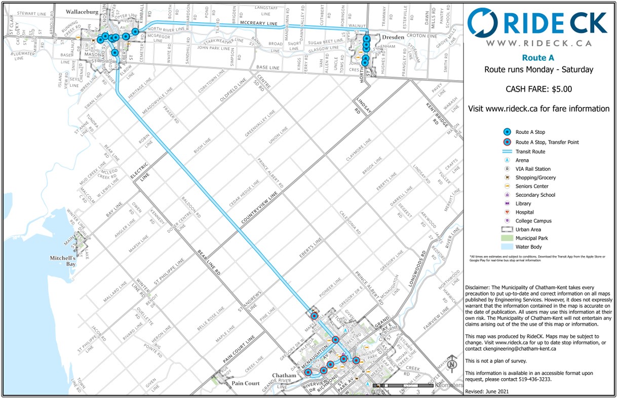
Three Ride CK routes — A, C, and D — extend from the bus terminal in Downtown Chatham to Wallaceburg (the second-largest community in Chatham-Kent), Dresden, Blenheim, Ridgetown, and Tilbury, covering most of the former towns that made up Kent County. (A fourth route, B, was proposed to serve Thamesville and Bothwell, but has not been implemented.) There is also a seasonal summer bus that serves the lakeside communities of Erieau and Mitchell’s Bay, echoing the former Chatham, Wallaceburg, and Lake Erie electric interurban service.
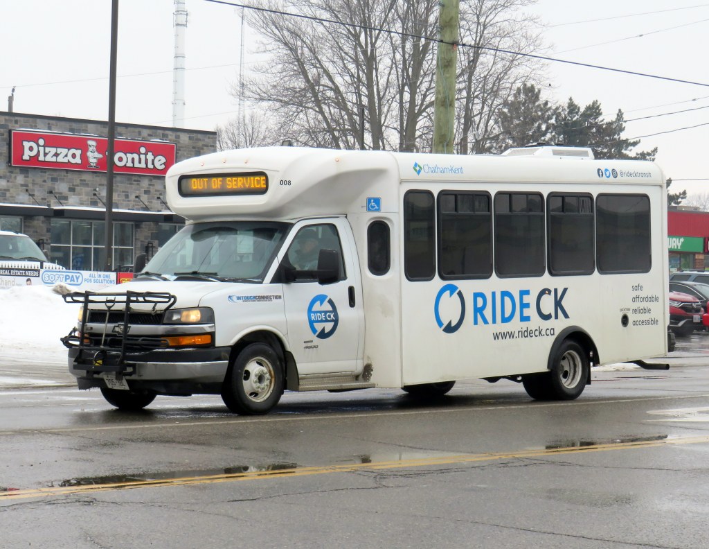
Most RideCK buses — local and intercommunity — are cutaways, meaning that the passenger seating area is in a separately-built body added to a cab and truck chassis. Though these vehicles are popular for paratransit services, low-ridership rural routes, and in smaller communities like Brockville, they do not offer a particularly smooth ride. However, they are an economical option for smaller communities.
Bus stop in Wallaceburg
Each of the three intercommunity routes operate Monday through Saturday, with two morning and two evening round trips, with an additional midday run that leaves Downtown Chatham at 12:15 PM on weekdays; this additional trip was added several years after service began. There is a timed transfer to the local Chatham routes, allowing for onward connections to shopping, schools, medical services, employment, or social activities. All three rural routes also stop at the hospital in Chatham. The midday trip was added to provide an early return home for anyone taking the bus from outlying areas, such as for a medical appointment, and not then stuck waiting an entire day in Chatham.
I rode RideCK between Chatham and Wallaceburg and back in early February 2026; the midday 12:15 departure had decent ridership with six other passengers leaving the bus terminal (a seventh got on at the big box retail cluster north of Chatham’s urban area); there were five other passengers on the way back south on the first evening bus (5:45 PM leaving Chatham). Given that Chatham-Kent has maintained the service for so long is indicative of how the rural buses are seen as a necessity in the municipality. In Wallaceburg, on-demand local transit is also available, a recent improvement by the municipality.
Intercommunity routes have a flat cash fare of $5.25 (though online materials still show the older $5 fare), though transfers to local transit are provided.
Ride CK Route A between Chatham, Wallaceburg, and Dresden
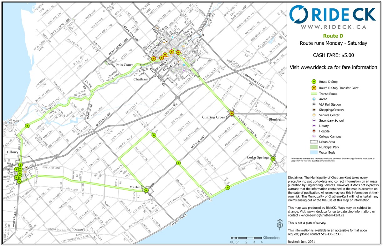
Though Routes A and C are fairly direct, Route D involves a long one-way loop to serve several small communities (including Cedar Springs, Buxton, and Merlin) before continuing to the former town of Tilbury and then back to Chatham. The route passes near, but does not stop at, Pain Court, and completely misses Wheatley.
The circuitous Ride CK Route D making a one-way loop through Cedar Springs and Tilbury
Though Chatham-Kent should be commended on identifying the need for rural transit and maintaining it for over two decades, it still demonstrates the challenges and gaps of operating a municipally provided rural transit service. Ideally, Chatham-Kent would be able to partner with neighbouring Lambton and Essex Counties to provide direct service to more communities. Tilbury should be part of an east-west service between Chatham and Windsor along the Highway 2 corridor, serving towns along Lake St. Clair such as Belle River. That would open connections to the University of Windsor and the main St. Clair College campus, along with other destinations, while improving service to Tilbury.
Route D, then, could be straightened and routed to serve Wheatley, even continuing west to make a connection to Leamington (which sadly, is losing its bus service to Windsor). With good scheduling, such connections could allow passengers to continue on VIA Rail service to London and Toronto.
Ontario needs a province-wide rural transit strategy with long-term funding and strong incentives to get reluctant municipalities (such as Halidmand County) on board. Until then, it is up to each local area to determine what, if any, transit service could look like, and up to residents to demand — and make use — of these services.
Unfortunately, the costs of maintaining this website and the ArcGIS Online portal to my maps continue to rise, especially as the amount of information provided and the number of views grow. If you enjoy my work and find the maps useful, please consider buying me a coffee to help with those costs. Thank you!
Interestingly, the 939B, which runs all the way from Kennedy Station to Finch West Station via Scarborough Centre, McCowan Road, and Finch Avenue, uses the York University Busway to get between Dufferin Street and Finch West Station. That busway, opened in 2009, was built to speed up travel times between the former subway terminus at Downsview Station (now called Sheppard West Station) and the university campus as the Line 1 extension to Vaughan was underway. When the Scarborough Busway opens — likely by the end of this year — it will use that exclusive transitway (also a temporary measure to speed buses along a subway project) as well.
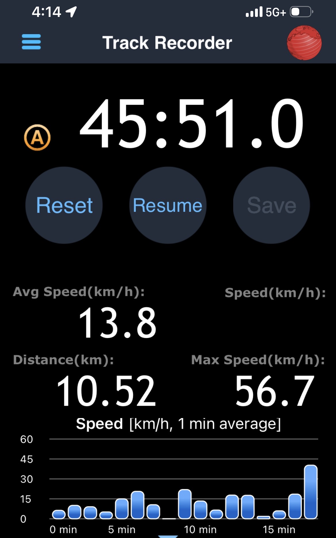
From Finch West Station, it took 44 minutes to ride to the other end at Humber College Station, 20 minutes faster than during a problematic ride back in December. The average speed was 14.1 km/h, with a short spurt of speed (up to 56 km/h) up the hill between Islington and Kipling Avenues.
Screenshot from a GPS app with the distance, average speed, and time it took to get from Humber College to Finch West Station
On the return trip, it took almost 46 minutes from Humber College to Finch West, less than 4 minutes faster than my last eastbound ride in December, and with an average speed of 13.8 km/h. The eastbound train I was riding managed to arrive at Kipling Avenue (Mount Olive Station) just as the LRT signals were turning from amber to red (motor traffic still had 10 seconds of green light), followed by the stop at the far-side station there. The train also managed to arrive at Islington Avenue as the LRT signal was turning red, resulting in another long wait. At each intersection, the trains crawled at 15-20 km/h as parallel traffic sped by, and the Alstom Citadis cars were noticeably rough riding. The section between Humber College Station and Westmore Drive is especially painful, with LRV cars making the turn at 7-8 km/h.
On Eglinton Avenue east, the two-car Bombardier Flexity trams manage to glide through at-grade intersections at a less frustrating speed, and they noticeably provide a lighter, quieter ride.
On the positive side, station dwell times on Line 6 were noticeably reduced, and it seems that operations are a bit more consistent after two months of operation; there were no notable gaps between LRV cars. However, there are still issues to be worked out, as Friday, February 27 saw more switch problems that closed part of the line for several hours.
Hopefully, further operational improvements and signal priority follow, and the signal and track issues get sorted out. I’ll return later in March for another ride to see if the ride improves further. I worry, though, about the Citadis LRVs, as they are looking more and more like a defective product that may not be redeemable.