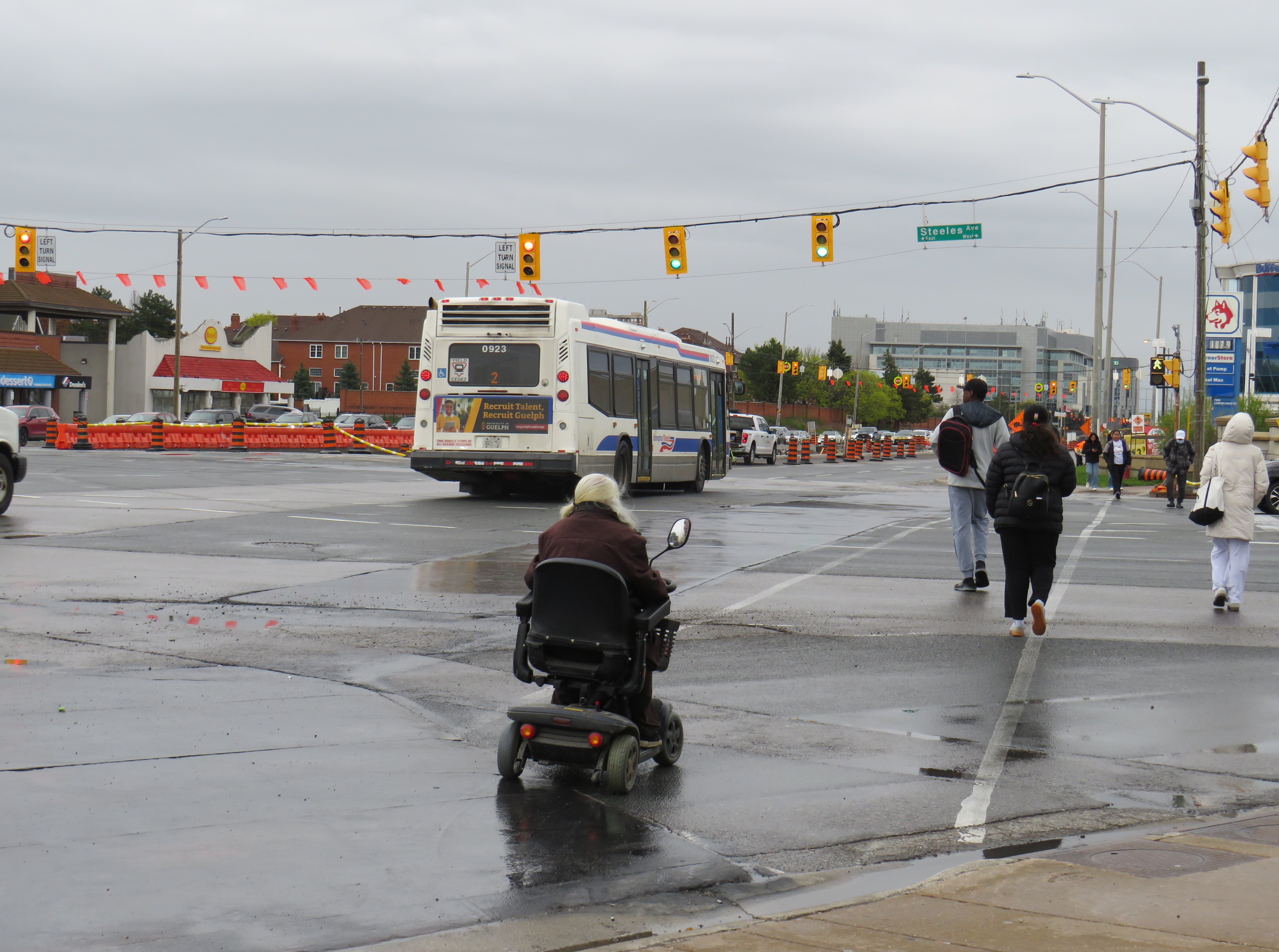
Hurontario Street, looking south from Steeles Avenue, where the first phase of the Hurontario LRT will terminate
The first phase of the Hurontario LRT, which will between Port Credit GO Station and Steeles Avenue in Brampton, is slowly taking shape after years of construction delays. In Spring 2026, eight years since construction started on the corridor, work on the LRT guideway into south Brampton has finally begun.
As I wrote in detail before, a previous iteration of Brampton City Council narrowly voted against the LRT entering downtown as a surface line in 2015. This was the version selected in the provincial environmental assessment. Instead, that council voted to study alternative corridors into Downtown Brampton requiring lengthy detours, and asking for the LRT northern terminus to be on the south side of Steeles Avenue, despite a major bus exchange — Brampton Gateway Terminal — on the north side of the intersection to accommodate all options. After the 2018 election, council recommitted to a Main Street alignment (though preferring a tunnel) and asked the province to restore the terminus on the north side of Steeles pending a decision on the final four kilometres into Downtown Brampton. In early 2026, only one of the six councillors opposed to the Main Street LRT ten years ago remains in office.
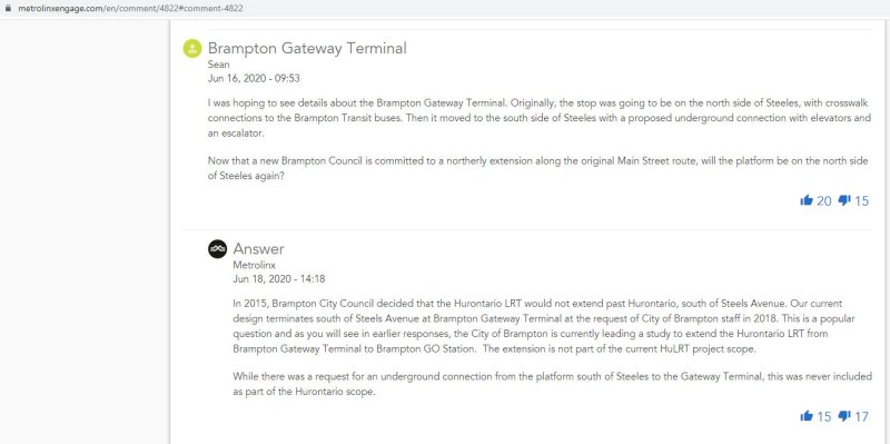
I wanted to follow up with Metrolinx to see how pedestrians would be safely accommodated at the Steeles and Hurontario intersection, given high traffic volumes, wide roads, and likely thousands of passengers switching between modes on a daily basis. Early concepts of an underground pedestrian tunnel were rejected by the province as out-of-scope, so pedestrians would have to cross both Hurontario and Steeles to make the transfer. Having no satisfactory answers despite many attempts to get an answer to this question, I took the lengthy and expensive route of submitting a freedom of information (FOI) request.
In summary, I learned that despite multiple requests from City of Brampton officials to restore the north side stop, Metrolinx and the provincial government refused. With the financial close with Mobilinx — the private-sector consortium selected to build, operate, and maintain the LRT — imminent in early 2019, there was no interest to make the minor change to facilitate the terminal, even though the city committed to taking on the cost on its own. The province was open to other changes to the line, however, as in 2022, it unilaterally renamed the line for a former Mississauga mayor and political ally of Doug Ford.
Looking south across Hurontario Street across a very busy multi-lane intersection towards the end of the LRT
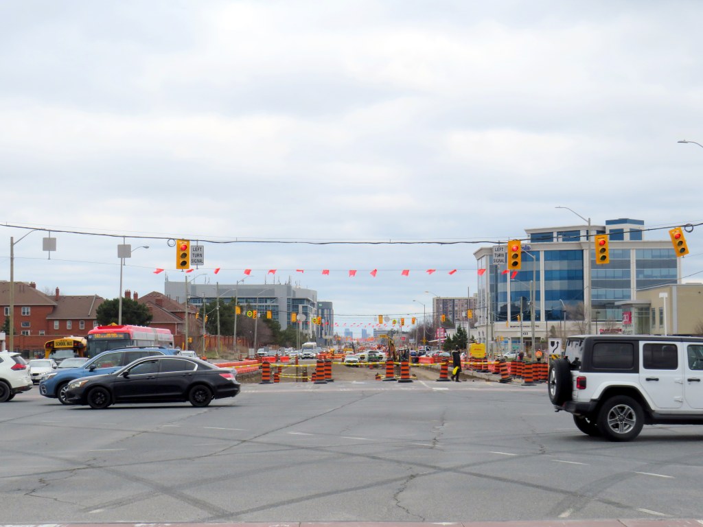
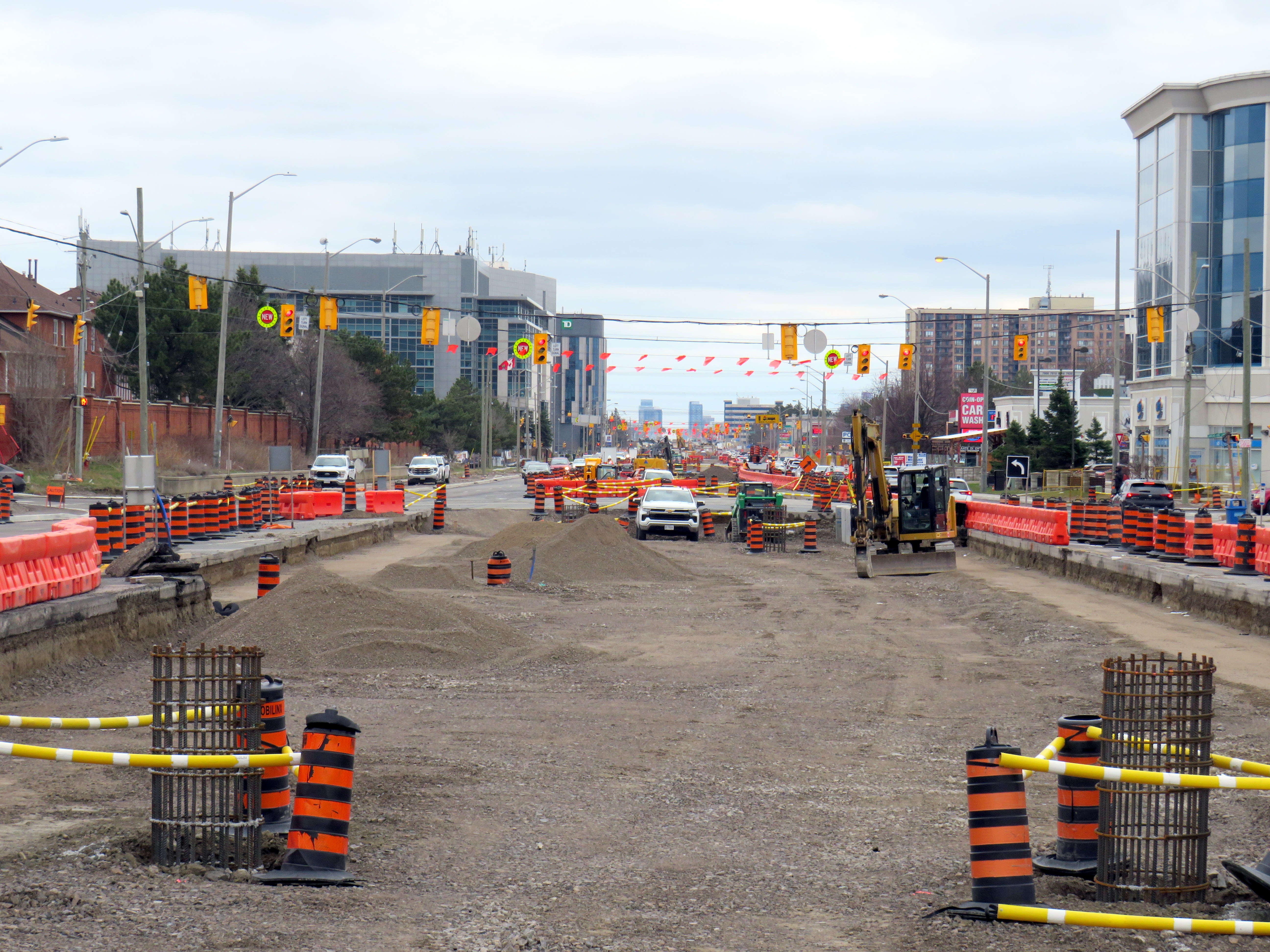
As work at the Steeles-Hurontario intersection is now well underway, it has become visually clear the problem will be once the LRT opens. The population around the Brampton Gateway Terminal area is rapidly growing; a 40-storey condominium tower on nearby Steeles Avenue West is nearing completion, with many more highrise and mixed-use developments planned, including the eventual redevelopment of Shoppers World Mall. Already, there are dozens who cross nine-lane Steeles Avenue hourly; once passengers have to transfer from the LRT to the transit terminal on the northwest corner, there will be hundreds.
Furthermore, once the (now-funded) Phase 2 of the LRT to Downtown Brampton is started, the intersection will have to be torn up yet again to extend the tracks across Steeles and build a new north-side stop. The province’s refusal to do this all at once is baffling, and will likely be much more expensive than if it was done right the first time.
Looking across from Gateway Terminal towards the future LRT terminus on Wednesday, May 6. Already, there are plenty of pedestrians crossing here.
Already, the costs of the current Mobilinx contract have ballooned while construction delays pile up. The Hurontario LRT was originally supposed to open in 2024. In 2025, Mobilinx had to completely rebuild the track intersection at Topflight Drive just south of Highway 407 after track was already laid in 2023 due to construction errors. In February 2026, Global News reported that only 45 percent of the track was laid. Due to delays and problems paying contractors, the consortium’s credit rating was downgraded by Standard & Poor to BBB, which is near junk status.
Given the multiple delays and difficulties building the LRT, work is only now at the point where the dangerous terminal location is being baked in. Even though construction errors are fixed, and the project name changed, Metrolinx has been unwilling to address the safety issue at Steeles Avenue that was raised many times. In the meantime, Metrolinx, Peel Region, and City of Brampton will have to figure out how to mitigate the potential disaster that is now in the making.
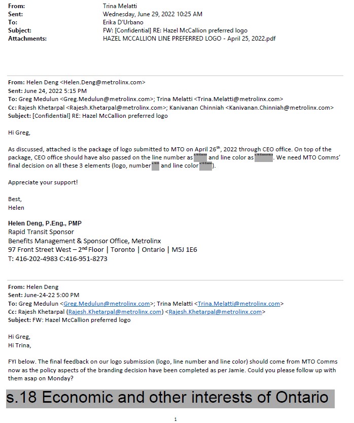
Though much of the information I received was redacted, I was able to learn that the Cities of Brampton and Mississauga had already come up with a brand for the new transit line. Metrolinx and the provincial government had to reimburse them for the costs once the Minister of Transportation intervened to force a new name upon the project, which cumulated with a love-in photo op on February 14, 2022.
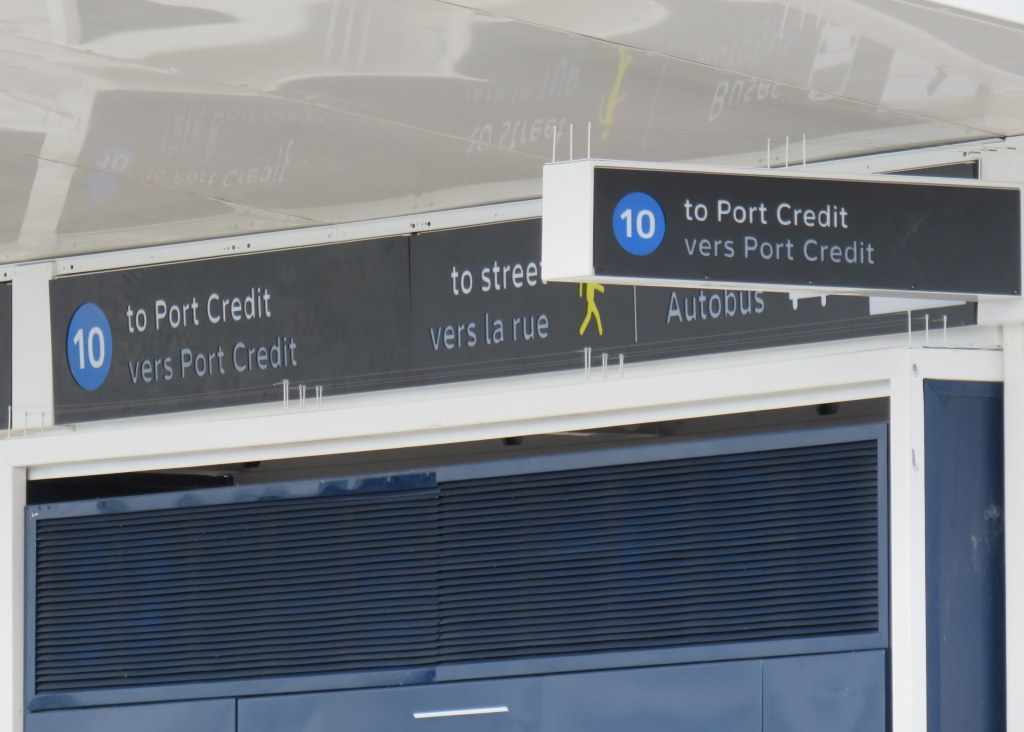
Among the information redacted in the information package sent to me, six months after my initial Freedom of Information request, was the LRT line’s colour and number. They were redacted under Section 18(1) of the provincial Freedom of Information and Privacy Protection Act, citing economic and other interests of Ontario.
Redacted line colour, number, and logo
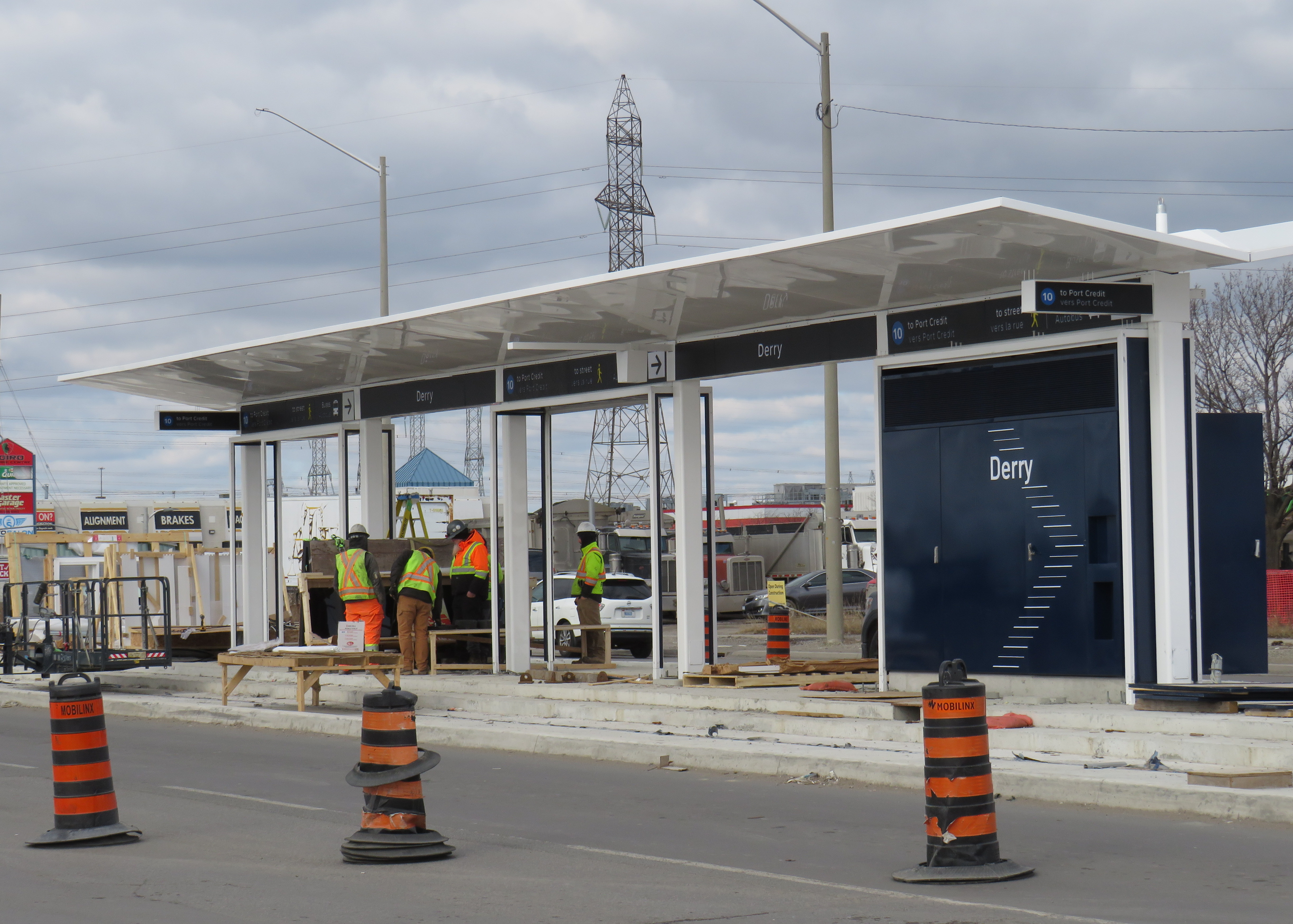
At Derry Road, though, the secret is out. The Hurontario Line will be Line 10, represented by a bright blue colour similar to the former Line 3 Scarborough RT.
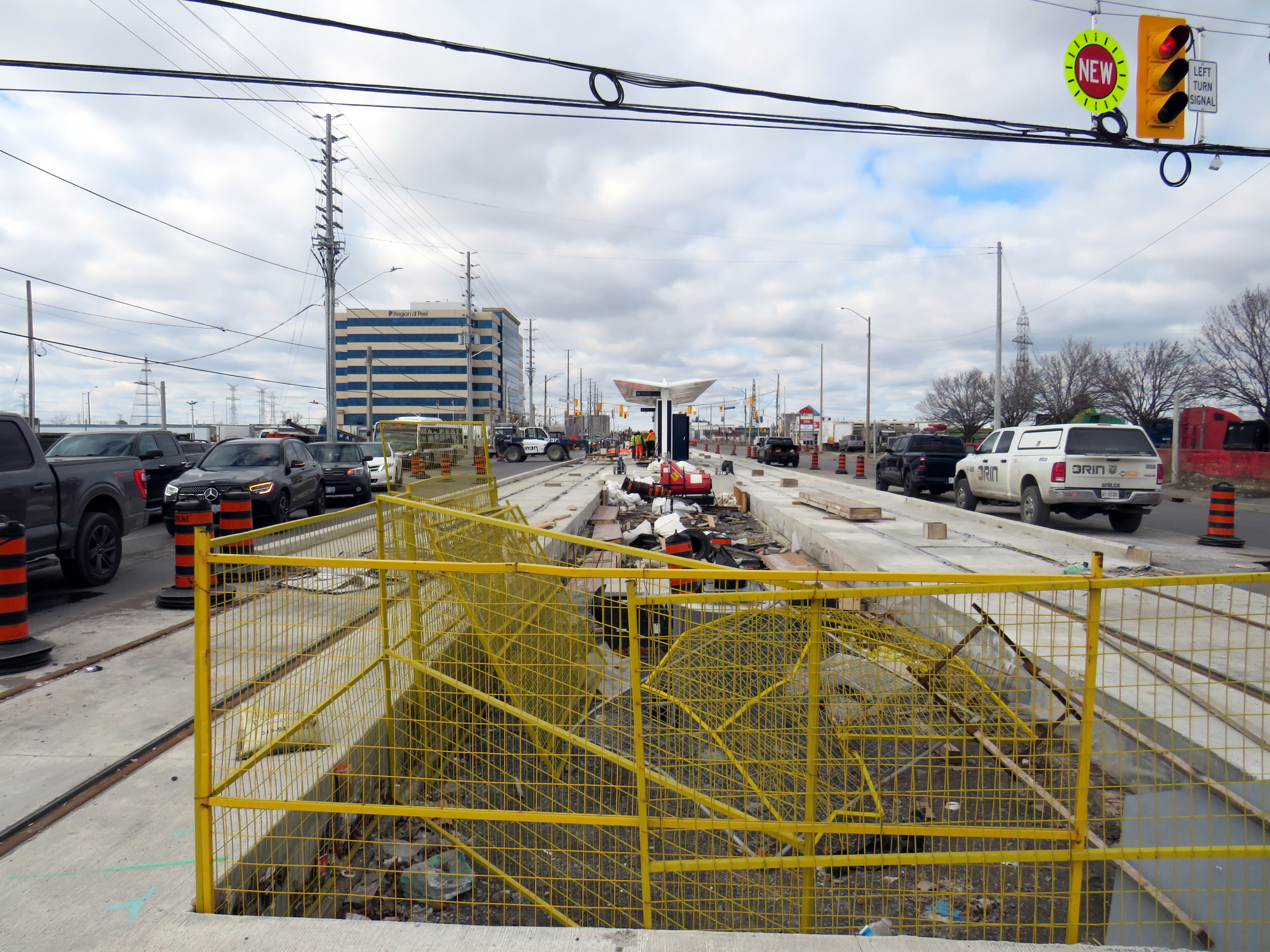
Derry LRT station under construction
Line 10 is a good choice for this corridor. Hurontario Street and Main Street through Mississauga and Brampton used to be part of provincial Highway 10, which was later bypassed by Highway 410 and downloaded to the two cities between the 1980s and the 2000s. It will also be the first Metrolinx-managed rapid transit project completely outside the City of Toronto, where Lines 1 through 6 are already assigned to the existing subway and the Eglinton-Crosstown and Finch West LRTs (with Line 3 reused for the Ontario Line when it opens).
Brampton Transit and Miway currently operate bus services with that route number (10 South Industrial and 10 Bristol-Britannia), but those should be easy to change in advance of the LRT’s opening, which will take place in late 2025 or early 2026, given the construction progress so far.
I remain puzzled and somewhat annoyed that this information was kept secret, and for what reasons. Revealing a line number and colour in a freedom of information request should not have been important. If it was to protect for another government photo opportunity, then that is now moot. Who is the Hurontario LRT for? The Doug Ford-led provincial government, or the people who will ride it?
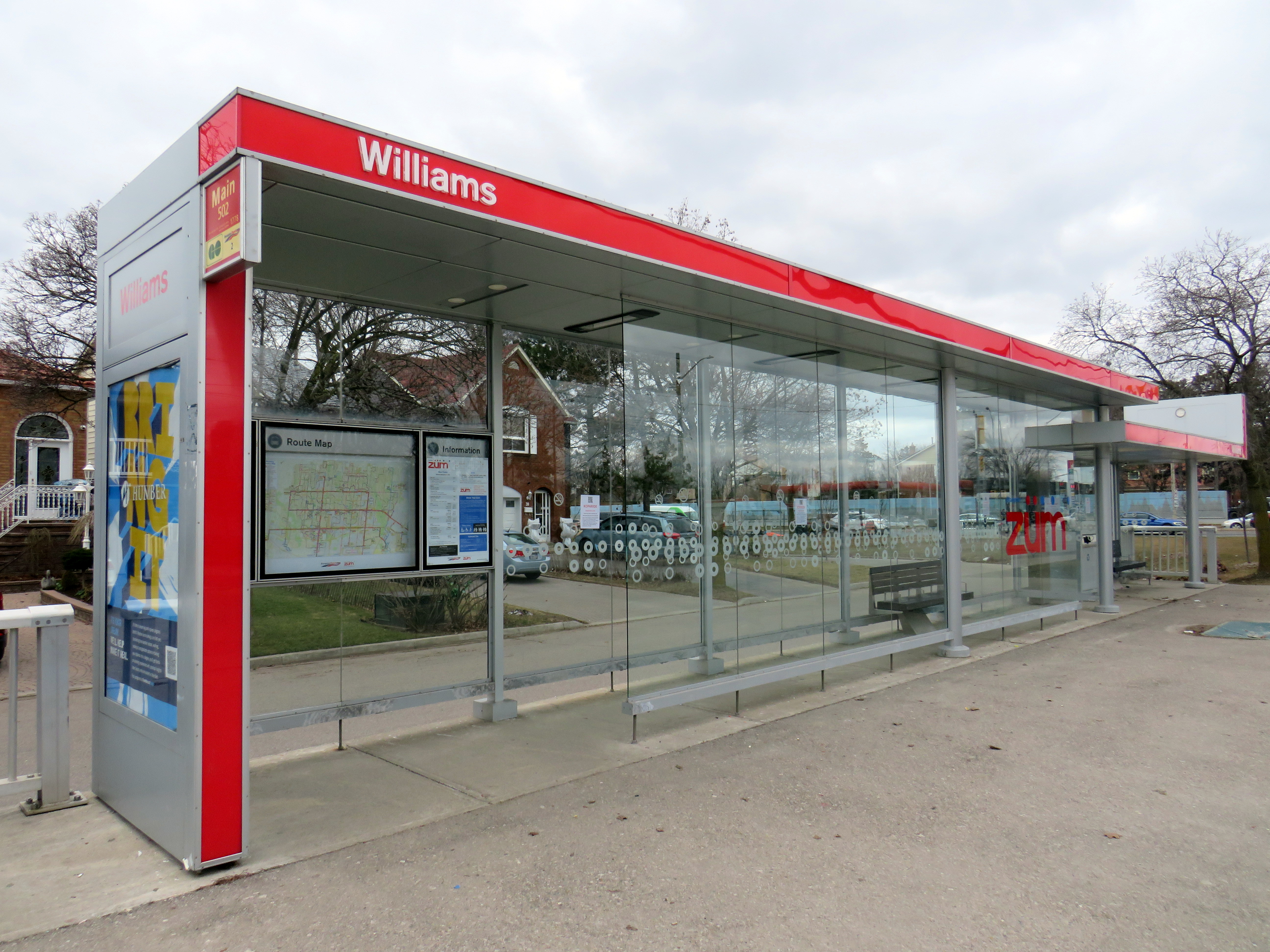
Finally, I note that like the shelters going up for the Finch West LRT and the surface stops of the Eglinton LRT, there is very little protection from the elements at the Hurontario LRT stops, with only a canopy and a single wall supplying shade and cover from the rain or snow. Compare the Derry Road LRT stop with older Brampton Züm shelters, which include enclosed waiting areas, benches, and even winter heating.
Brampton Züm stop with full glass enclosure, benches, and a button to activate a heater in the winter
One more thing…
To my longtime followers as well as my occasional readers, thank you for your interest and support. Last year’s FOI request cost me $525.00. Sadly, freedom of information isn’t free. If you like my work and want to contribute to my online mapping and webhosting costs, please consider buying me a coffee.
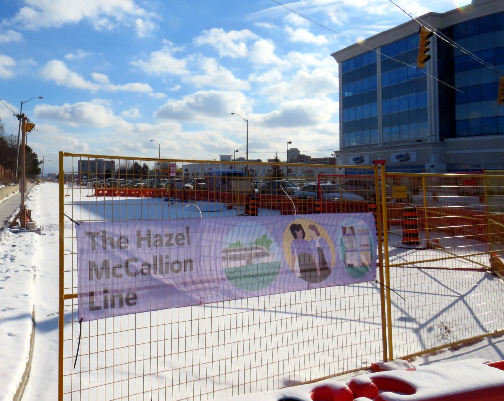
Banner promoting “The Hazel McCallion Line” on Hurontario Street in Brampton, January 2024
Previously on this website, I wrote about the renaming of two GO Transit stations: Oshawa and Brampton. I explained why renaming transit infrastructure is problematic, especially when they violate wayfinding standards, which call for simple, accurate, unique, and self-locating names.
Both GO Transit stations were renamed by provincial agency Metrolinx, on behalf of the provincial government. Metrolinx operates GO Transit buses and trains, the UP Express airport link, administers the Presto fare payment system, and oversees the construction of new rapid transit projects in the Greater Toronto and Hamilton Area. The Hurontario LRT, which is currently under construction between Port Credit GO Station in Mississauga and Steeles Avenue in Brampton, is just one of many transit projects managed by Metrolinx.
On February 14, 2022, at Cooksville GO Station, Premier Doug Ford, then Transportation Minister Caroline Mulroney, then Mississauga Mayor Bonnie Crombie, and Metrolinx CEO Phil Verster joined former Mississauga mayor Hazel McCallion announcing the name change from the Hurontario LRT to the Hazel McCallion LRT. The occasion also marked McCallion’s 101st birthday.
Hazel McCallion with Metrolinx CEO Phil Verster, February 14, 2022 (Metrolinx photo)
This is the first rapid transit line in North America to be named for a person, contradicting established standards for transit projects.1 Though McCallion was a formidable and popular mayor whose political career spanned seven decades, she was also very close to the Ford government in the last few years of her life. She also had many other public facilities named in her honour — a senior public school in Mississauga’s Streetsville neighbourhood, the library at University of Toronto’s Mississauga campus, the City of Mississauga’s central public library, a walkway leading to Square One Shopping Centre, and the Mississauga campus of Sheridan College. There is also the Hazel McCallion Auditorium at Mississauga Valley Community Centre and the Hazel McCallion Hall at Vic Johnston Community Centre. There was no need for yet another civic asset to be renamed for her.
In Toronto, most former mayors have just one public asset named for them: David Crombie, Art Eggleton, June Rowlands, and Barbara Hall have parks dedicated in their honour. Mel Lastman — mayor of North York for 24 years before being elected mayor of amalgamated Toronto for another six — and Nathan Phillips have major public squares.2 In Mississauga, there was no need to rename yet another piece of civic infrastructure for the same person.
Furthermore, there was no public consultation about the name change — even officials at the cities of Brampton and Mississauga were kept in the dark — while the name itself contravenes Metrolinx’s own naming conventions.
In July, 2023, I submitted an access to information request to Metrolinx, the second time I went through the freedom of information process to find out more about the light rail transit project. There were several delays, and I did not receive my requested documents and communications until late January 2024.
A deep dive into the background of the Hurontario LRT project, the person it is being renamed for, and my findings and impressions follow.
This section of the LRT, planned last decade, was narrowly rejected by Brampton City Council in a 6-5 vote, with then-mayor Linda Jeffrey supporting the transit line’s construction. Unfortunately, six city councillors sided with several downtown merchants and affluent Main Street South residents (including former premier Bill Davis), who did not support a surface tram on Main Street, back in October 2015.
In 2019, a newly elected council, led by a new mayor, Patrick Brown, was willing to revisit the LRT decision, again backing a direct Main Street alignment. City staff were directed to update the original, approved 2014 Transit Project Assessment Process (TPAP). In 2021, staff narrowed the alternatives to just two options: an all-surface alignment from Steeles Avenue to the GO station in Downtown Brampton, and an underground option between Nanwood Avenue and the rail corridor. Meanwhile, Brampton staff and elected officials tried, without success, to restore the north-side LRT terminal at Steeles Avenue/Gateway Terminal.
Now that the 30% design work for the two options is complete, city officials must decide how to proceed, especially if they expect senior levels of government to cover the costs of this major transit project.
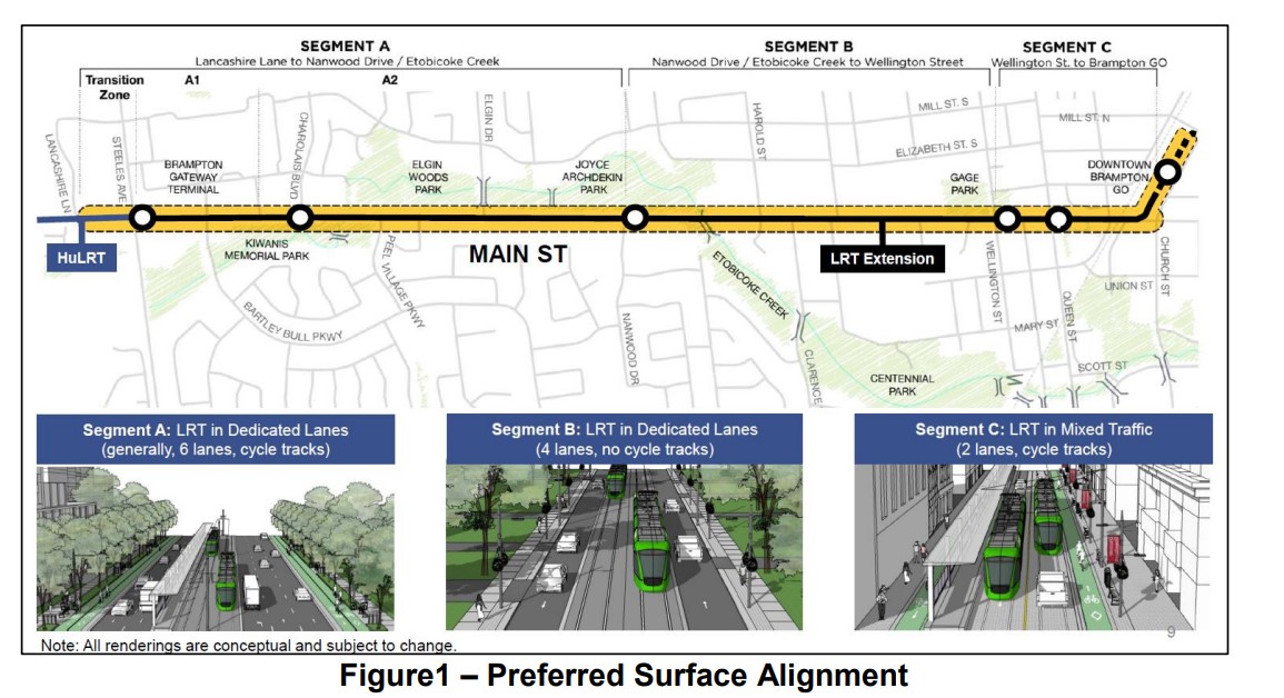
The alignments
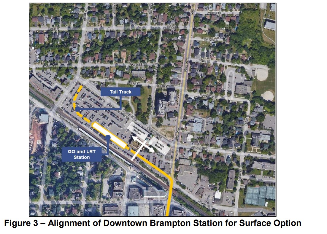
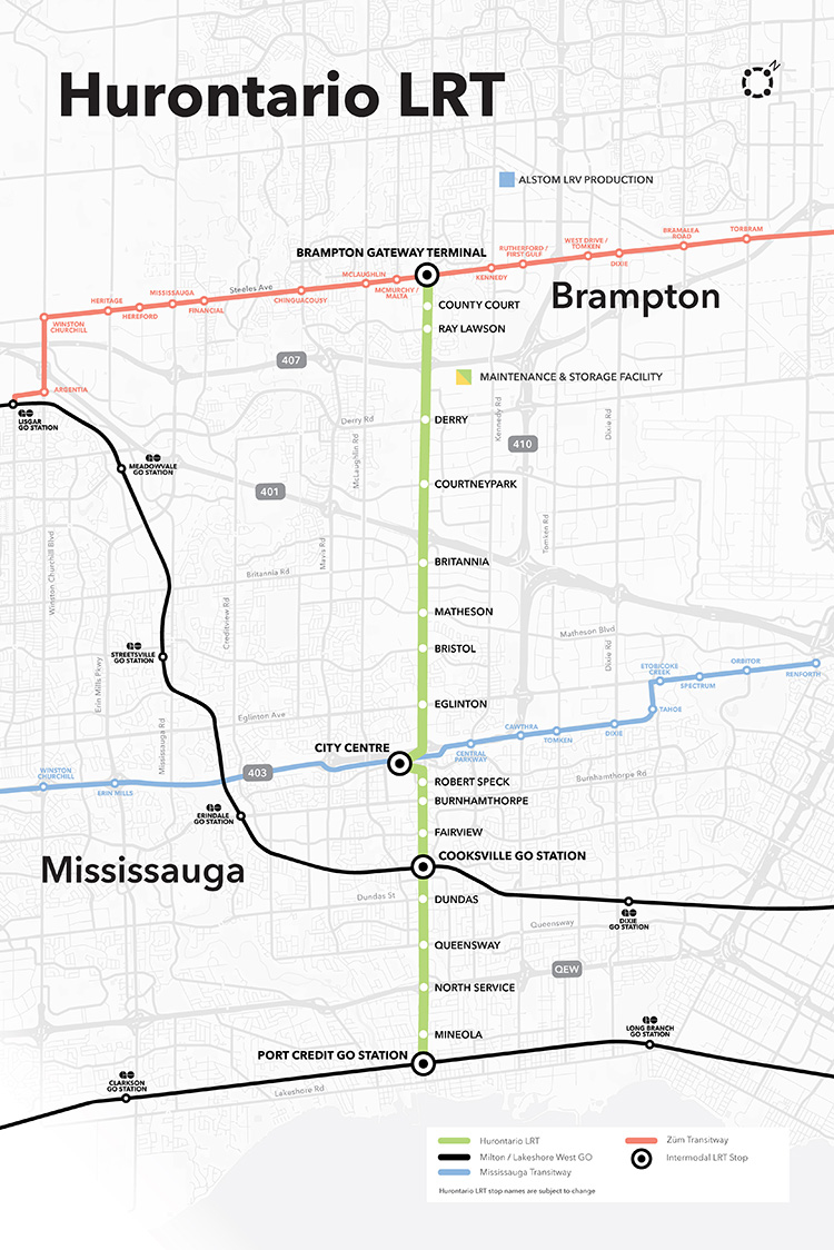
The all-surface alignment three stops in each direction between the Gateway Terminal at Steeles Avenue and the Brampton GO Station: at Charolais Boulevard, Nanwood Drive, and split northbound and southbound stops between Wellington and Queen Streets. These stop locations match the existing 502 Züm Main stops on this section of Main Street.
Between Nanwood Drive and Wellington Street, the LRT would operate in dedicated lanes, with general traffic in the outer two lanes. There would not be room for bicycle lanes, and left turns would be prohibited at non-signalized intersections. North of Wellington, the LRT would run in mixed traffic, with cycle tracks and widened sidewalks on both sides of the street.
The preferred surface alignment
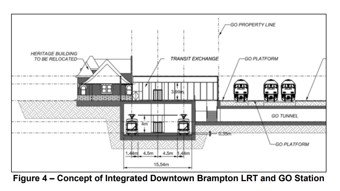
The northern terminus would be on the GO Station property, on the west side of Main Street, in a below-grade trench. Stairs and elevators would connect the platform with the GO Station, while the historic 1907 station building would be moved to support GO train service expansion on the busy CN freight corridor. The street surface would need to be lowered by one metre for the light rail vehicles and the overhead wire to clear the railway underpass.
Alignment of off-street surface LRT alignment on the GO Station property Design concept for the GO and LRT terminal
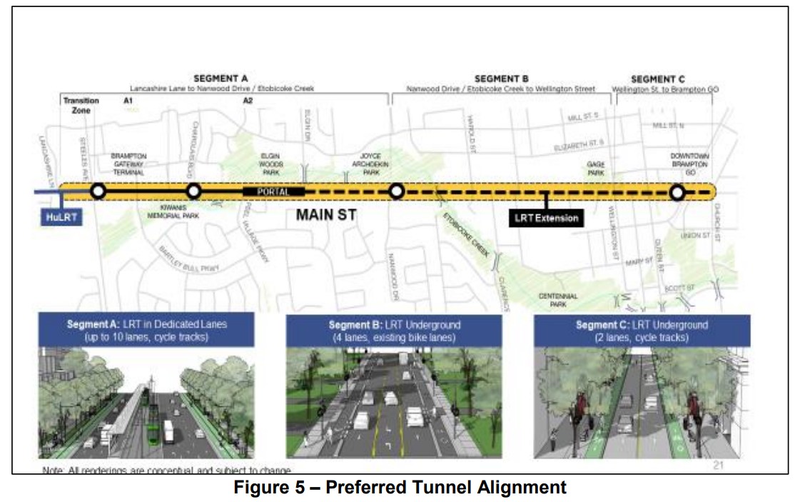
The tunnel alignment – which was not part of the approved 2014 TPAP – includes the same surface stops at Brampton Gateway Terminal and Charolais Boulevard, and two underground stations, at Nanwood Drive and the terminal, just south of the GO Station. Between Elgin and Nanwood, the tunnel would be dug in the traditional cut-and-cover method while the portion under Etobicoke Creek and the downtown core would be constructed using the sequential excavation method.
The tunnel portal would be located at Elgin Drive, several hundred metres south of Nanwood. The longer tunnel section is required to avoid the Etobicoke Creek floodplains. Though Nanwood Drive has no intersecting transit routes and relatively low density, the rundown Brampton Mall property would be an ideal urban development site, as would the commercial properties immediately to the south.
The preferred tunnel alignment
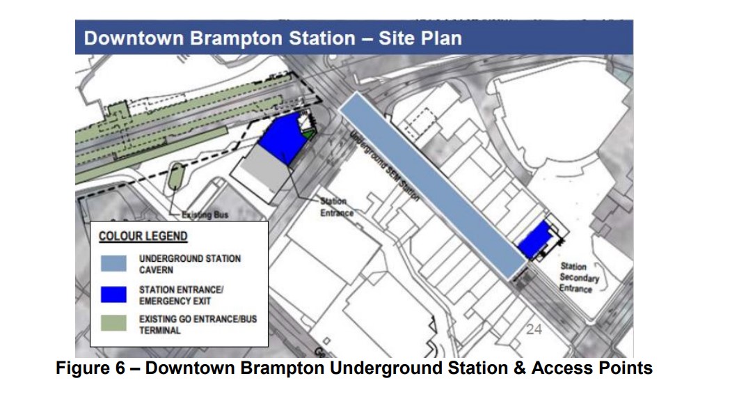
The downtown terminal station would include a primary access at the corner of Main and Nelson Streets, to provide access to the GO Station and the proposed new transportation hub, as well as a secondary entrance closer to Queen Street and Garden Square.
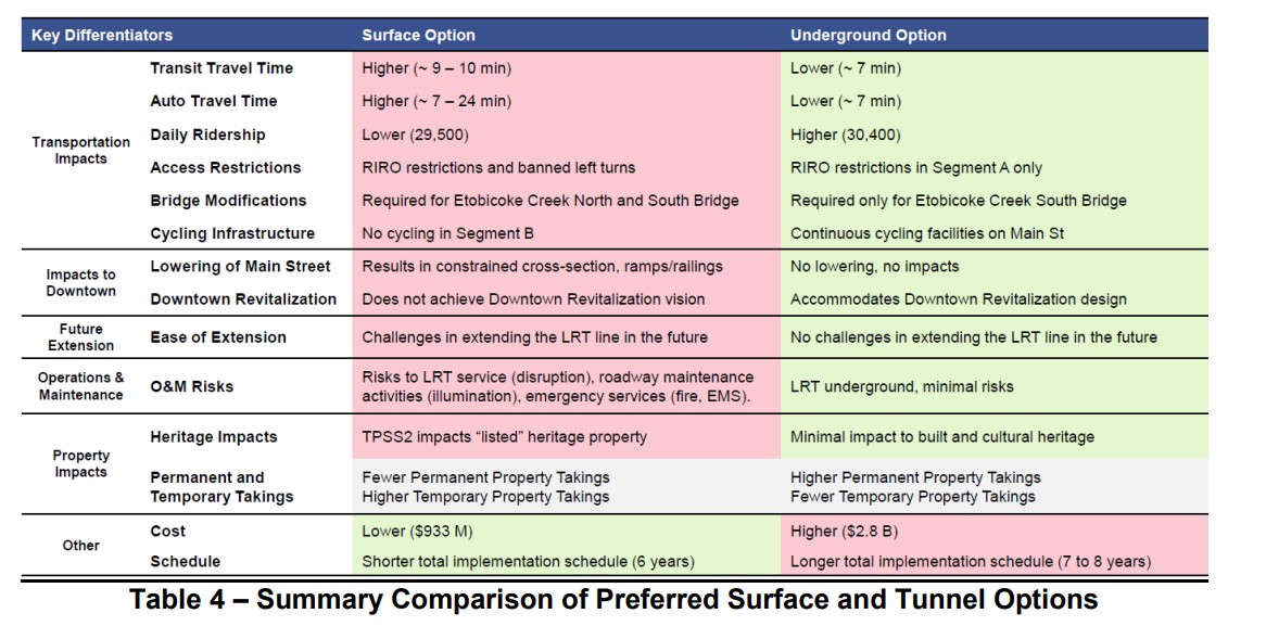
The two options were compared, putting the tunnel alignment ahead in all categories apart from cost and schedule. The tunnel would allow for continuous cycling infrastructure on Main Street, minimize traffic impacts, while having slightly higher ridership and somewhat faster transit. The tunnel would also better satisfy homeowners and businesses along the corridor. Staff also note that the tunnel alignment, without the bend into the GO station property, would be easier to extend farther north.
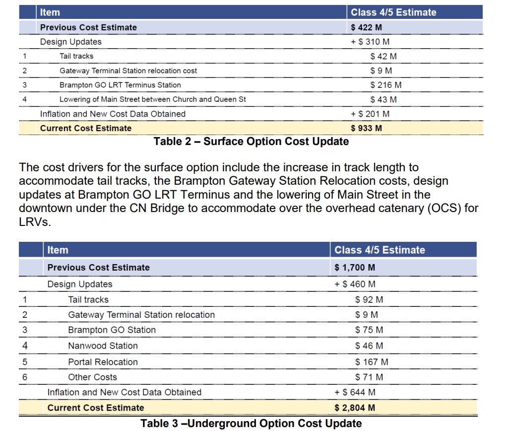
As with other transit projects, the costs of delaying this segment of the LRT are subject to inflation. The surface alignment would cost $933 million, while the tunnel route would cost $2.8 billion. The surface option would take one to two fewer years to complete, an important consideration given Brampton’s fast-growing transit ridership and delays on other complex LRT projects, such as the Eglinton-Crosstown line.
Cost comparisons for the tunnel and surface alignments
The Pitch
Towards the end of the staff report is a section called “Funding Advocacy.” Staff rightfully point out the need for the LRT extension, given the city’s and the province’s goals of directing high density development to the downtown core and other transit station areas, as well as the city’s record of continuous ridership growth and transit improvements.
They also point out that the funding that Brampton is seeking (for the Queen Street BRT project and the LRT, specifically the tunnel option) is comparable to other transit projects in the Greater Toronto and Hamilton Area. The table below compares the costs and funding sought for Brampton’s proposed projects to those funded and underway in Toronto and Hamilton.
Table comparing costs, funding and system ridership for Toronto, Hamilton, and Brampton
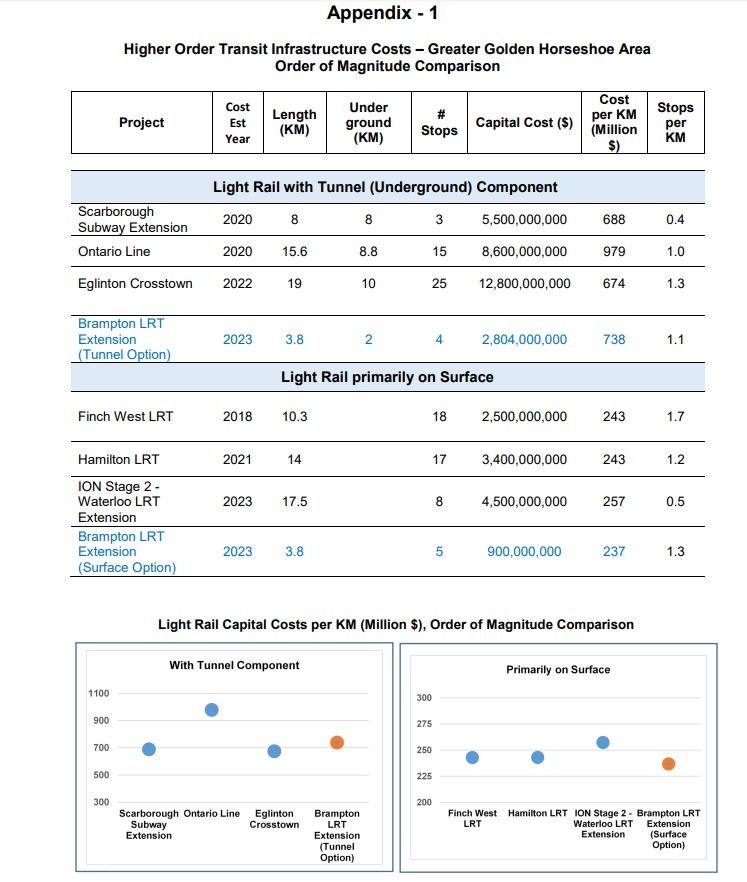
An appendix to the staff report compares the cost of the tunnel option with other tunnelled Ontario projects (the Scarborough Subway Extension, the Ontario Line, the Eglinton-Crosstown), and the surface alignment with other surface projects (Finch West LRT, Hamilton LRT, Ion LRT extension in Cambridge).
Concluding thoughts
It is still a shame that Brampton City Council put the interests of a small, but affluent, minority of voters first back in 2015-2016. Had they not prevailed, the LRT into Downtown Brampton would have been under construction right now – at the same time that critical water infrastructure is being replaced in Downtown Brampton, and we would be looking forward to it being open in just two years. However, just three of the eleven council members that voted on the LRT in 2015-2016 remain at Brampton City Hall, and two of those three councillors supported the original project.
The arguments in favour of the tunnel are enticing: a faster transit ride though a congested part of the city, an appeal to provincial and federal governments that have historically short-changed Brampton on its infrastructure needs, in a city that will have six seats up for grabs in the next elections.
However, a surface LRT will be quicker and much cheaper to build. I also do not see the need for further extensions northward, at least via Main Street, and even then, it would require a second tunnel portal somewhere near Vodden Street, adding at least $1 billion to future costs. The GO station terminal points towards the abandoned Orangeville-Brampton Railway, which could provide a good alignment northward from Downtown Brampton, even with a parallel cycling path.
More than anything, I want to see the Hurontario-Main LRT completed to Downtown Brampton as soon as possible, especially as work progresses on all-day hourly train service between Toronto and Kitchener and revitalization and intensification of Downtown Brampton accelerates.
The provincial government has signaled that they prefer the surface alignment for cost reasons (notwithstanding it spending billions of dollars on an unnecessary tunnel on Eglinton West in Etobicoke), as does the Brampton Board of Trade. It is also worth noting that this study is only at the 30% design phase, detailed engineering work may find further costs.
The surface option was the right choice in 2015, and it remains the right choice today. This time, maybe, Brampton will get it right.
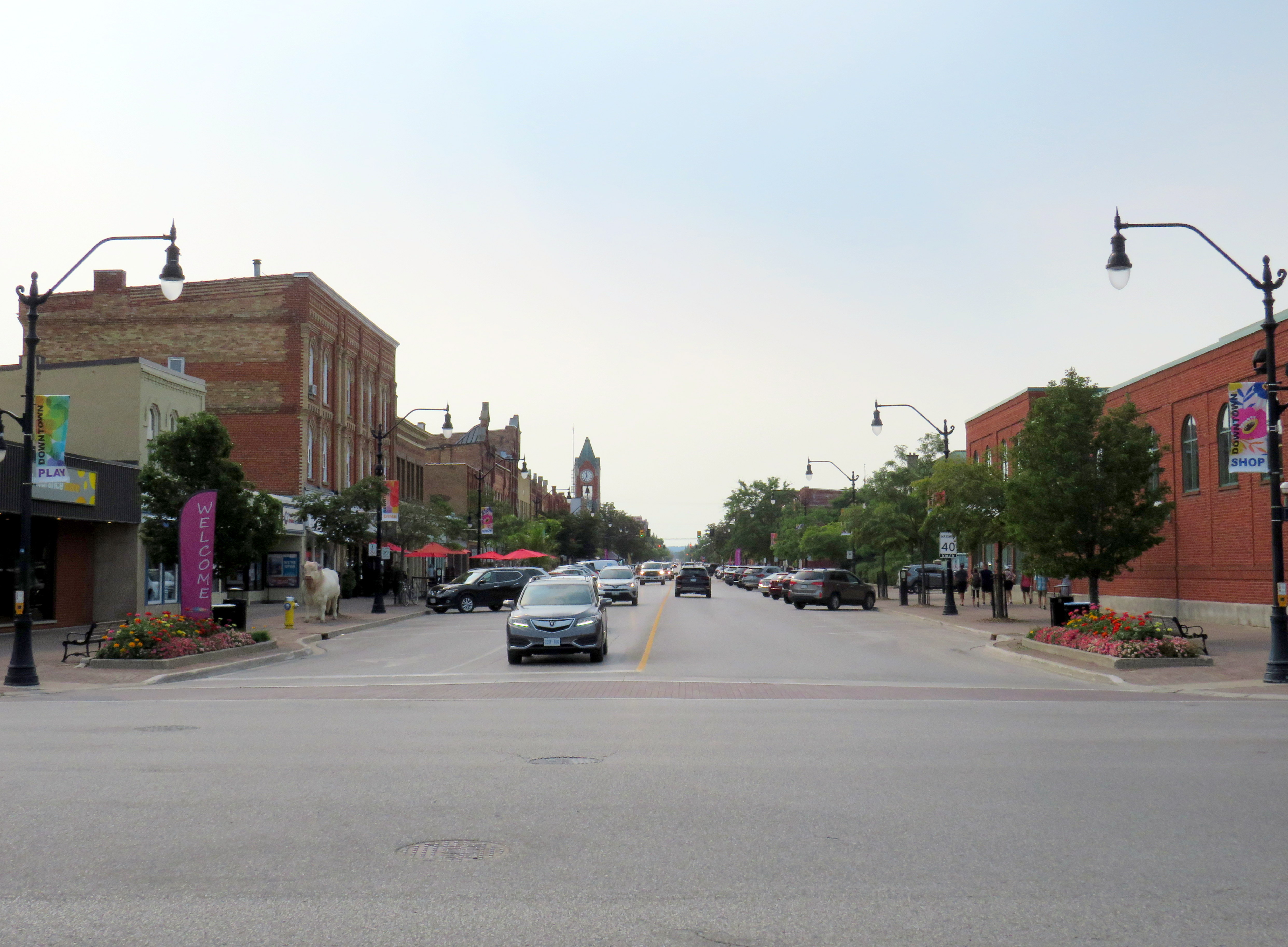
Looking north from Lake Ontario up Hurontario Street in Port Credit
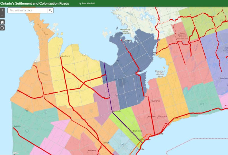
Ontario’s first roads were trade routes established by First Nations, including the Toronto Carrying Place, which linked Lake Ontario, Lake Simcoe, and Lake Huron. These routes followed the topology and existing water courses, making navigation simple and avoiding steep hills. Many modern streets, such as Toronto’s Davenport Road, follow these old trails.
With the establishment of the British colony of Upper Canada, new roads were established that took straight lines, instead of following existing trails or the lay of the land. Governor John Graves Simcoe named two of these routes — Yonge Street and Dundas Street — after British officials. Though Yonge and Dundas Streets were established for military purposes, they soon became used for settlement.
Hurontario Street — a portmanteau of “Huron” and “Ontario” — was among the first of a new wave of roads laid out by colonial officials, established for settlement purposes. These colonization roads were built across southwestern and south-central Ontario and became the basis for the concession land grant system that forms the grid of country roads and arterial avenues throughout Southern Ontario.
Other roads surveyed and built in this period included Simcoe Street, which connected Lake Ontario (at Oshawa) with Lake Scugog (at today’s Port Perry); Brock Road, which ran between Hamilton Harbour and Guelph with branches towards Lake Huron near modern-day Port Elgin (Elora Road) and towards Owen Sound (Garafraxa Road). Huron Road led west from Guelph towards Goderich through lands held by the Canada Company.
Hurontario Street followed a nearly straight line north from Lake Ontario, perpendicular to the shoreline, with only a slight bend near present-day Orangeville to reach Georgian Bay at a perpendicular angle. Together with the Toronto-Sydenham Road, which branched off northwest towards Owen Sound, it quickly became an important route.
Taverns, villages, and towns were established along the way, including Cooksville, Buffy’s Corners (which incorporated as the Village of Brampton in 1853) and Collingwood. Collingwood proved to be an excellent harbour and became famous for its shipbuilding industry.
Looking south from Georgian Bay up Hurontario Street in Downtown Collingwood
But Hurontario’s straight trajectory was a problem. For the first 57 kilometres, the straight line was sufficient, as it followed a mostly flat route through present-day Mississauga and Brampton and climbed the Niagara Escarpment on a relatively gentle incline in Caledon. But through Dufferin and Simcoe Counties, the surveyed route went up and down several steep hills on the edge of the escarpment, including Hockley Valley and Boyne Valley. The final descent down the Niagara Escarpment towards Collingwood was very steep.
Early settlers were granted low-cost or free land grants in exchange for clearing and improving their land and maintaining the new settlement roads being drawn across southern Ontario. They rerouted troublesome segments of the surveyed roadways and either abandoned the surveyed road allotments or designated new survey lines for through traffic. In Dufferin County, traffic switched to the first concession line to the west, which offered an easier path towards Owen Sound. The Town of Orangeville was established where the route deviated.
Hurontario Street on the eastern outskirts of Orangeville, crossing the old alignment of Highway 9. Highway 10 curves on a bypass around Downtown Orangeville in the background.
Like many early roads, Hurontario Street’s importance declined with the growing network of railways in Ontario. In 1855, the Ontario, Simcoe and Huron Railway reached Collingwood and the Great Western Railway opened between Toronto and Hamilton. The next year, the Grand Truck Railway opened its line through Brampton; the Toronto, Grey and Bruce Railway (TG&B) reached Orangeville 15 years later. Soon the TG&B built all the way to Owen Sound, closely following the Toronto-Sydenham Road.
Hurontario Street is a discontinuous dirt road north of Island Lake at Orangeville.
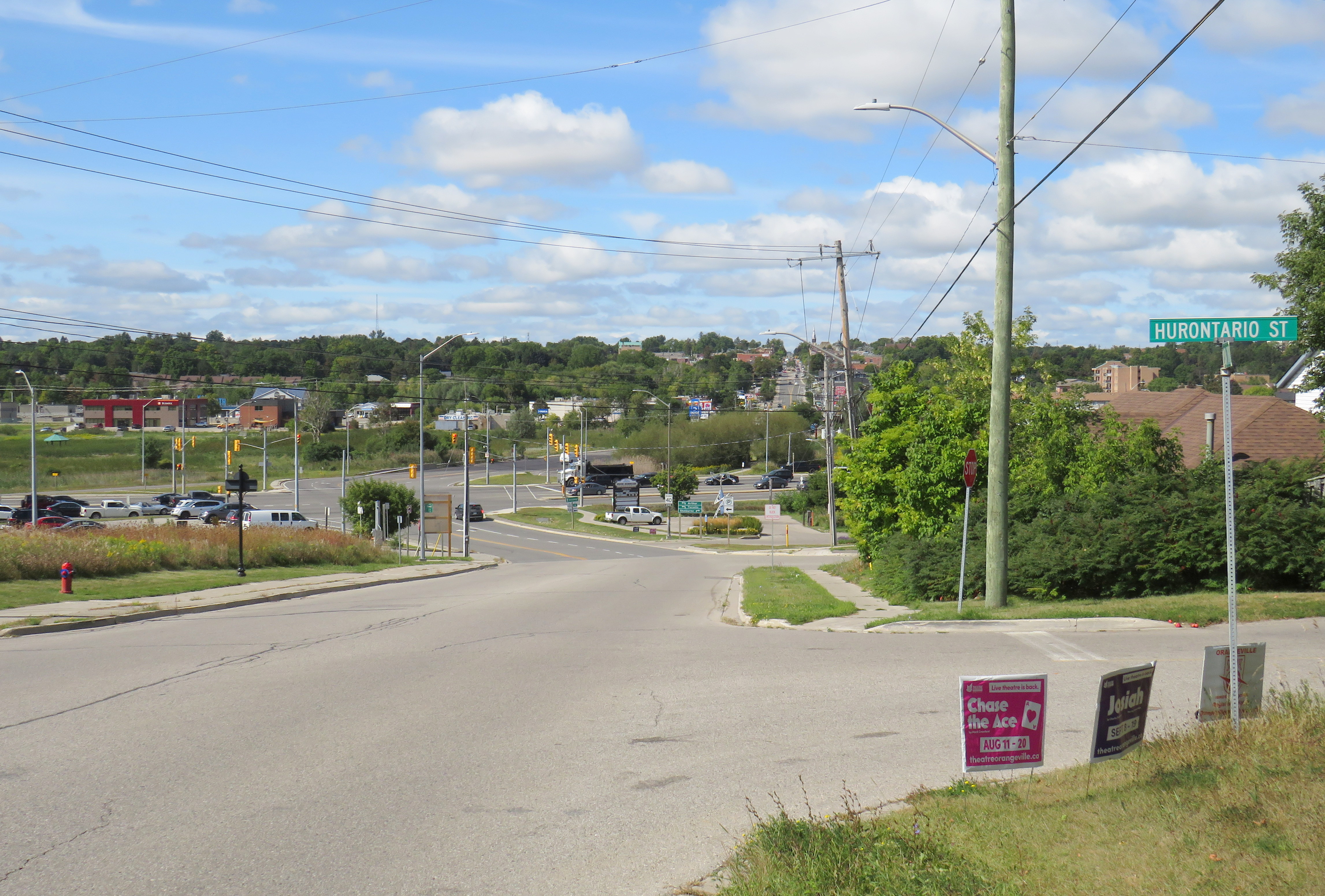
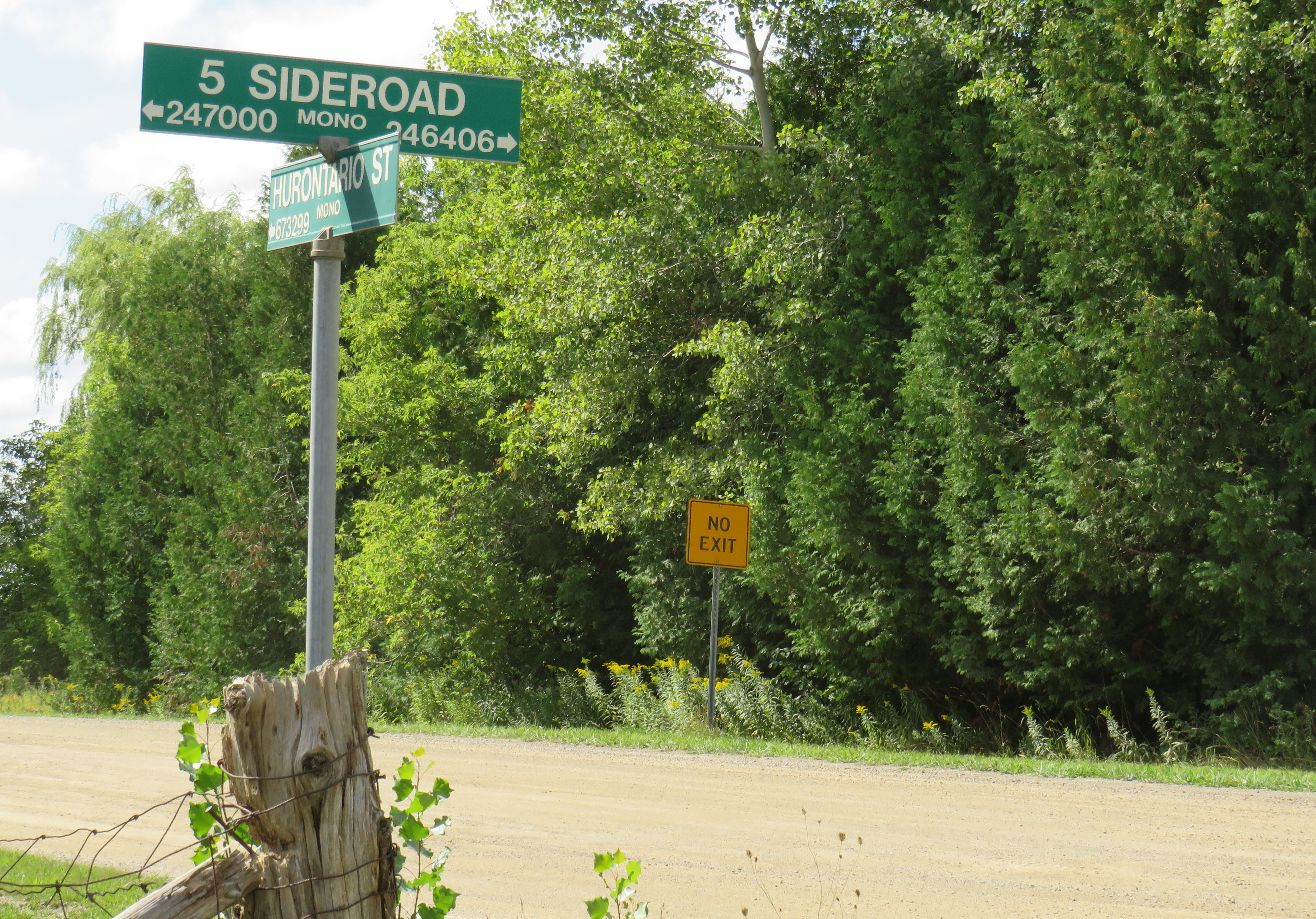
With the rise of motor vehicles in the 1920s, the Province of Ontario began establishing a highway network; the historical settlement roads became the foundation of this new system of roadways. Highway 10, one of the first 16 routes established by the province, followed the Toronto-Sydenham Road and Hurontario Street between Owen Sound and Port Credit, though it used the well-travelled First Line West through Mono Township, rather than the old, partially abandoned Hurontario Street alignment.
Highway 10 increased in importance through the 20th century, especially when Toronto’s postwar growth reached Mississauga and Brampton. Highway 410 was built to relieve congestion on Highway 10 and other nearby routes; by 2019, the new highway connected with the old route north of Brampton, and Highway 10 through Mississauga and Brampton was no more, once-again simply known as Hurontario Street except in the older part of Brampton, where it remains Main Street.
Meanwhile, the railways have fallen to the modern highway. The old TG&B, later acquired by Canadian Pacific, abandoned the Orangeville-Owen Sound line and its connecting branches by 1995. In 2021, the last train from Orangeville made its departure.
As Mississauga and Brampton continue to grow, a new light rail transit line is being built on Hurontario Street. In a deviation from Metrolinx norms, instead of honouring the road on which this line is built, the PC-led government decided to name the LRT after Hazel McCallion, the former Mississauga mayor who, despite leaving some challenging legacies, has had many publicly funded spaces named for her. Time will tell whether residents will adopt the new name or, instead, favour a name that reflects the historical and contemporary importance of Hurontario Street. My hope is that transit users will continue to use the 200-year old name they’re most familiar with.
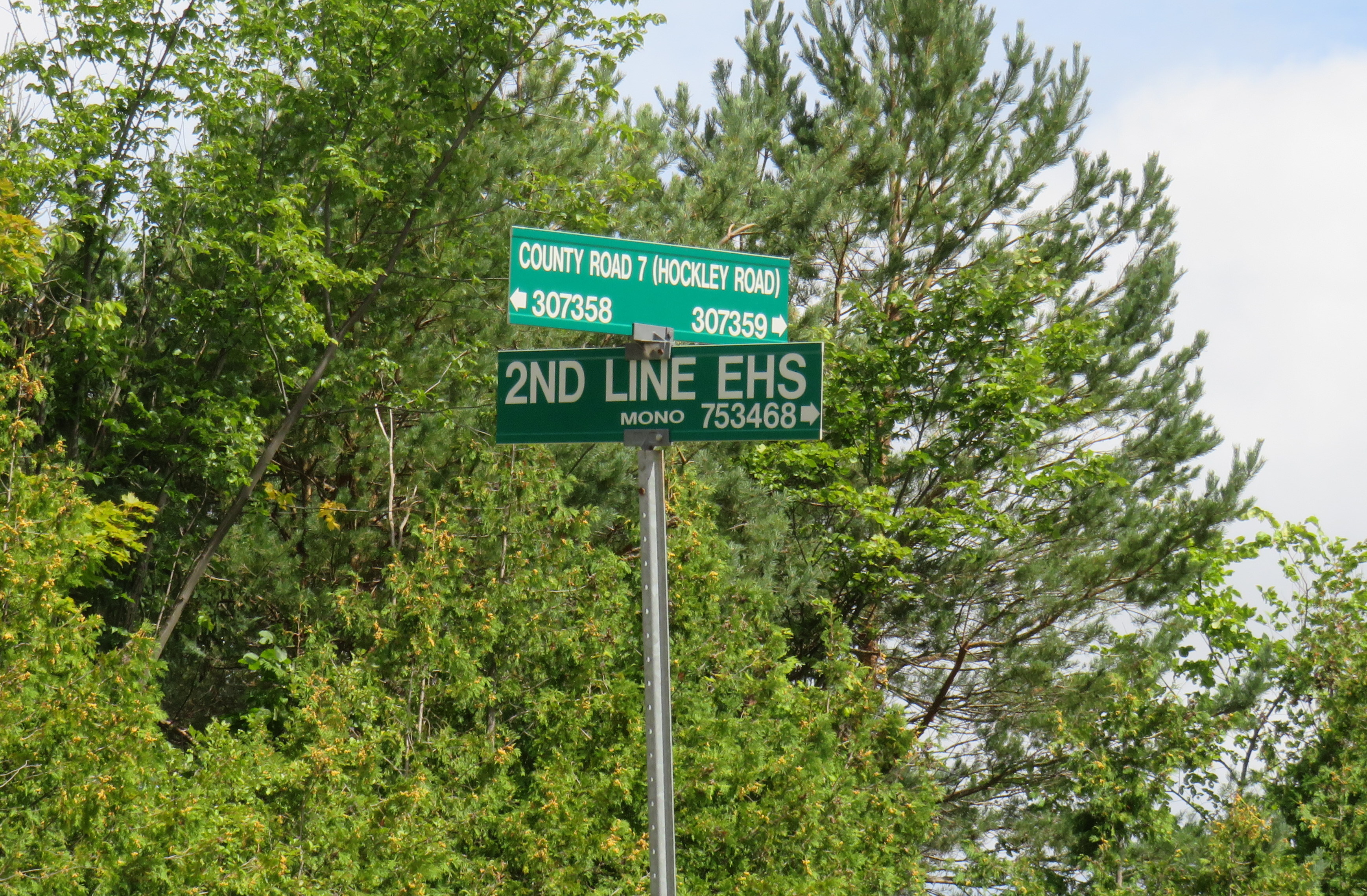
What does First Line West or 2nd Line EHS mean?
In Mono Township, the concession lines are numbered sequentially from how far east or west they are from Hurontario Street, which was the original basis for the land surveys. For example, 2nd Line EHS can be found two roads east of Hurontario Street. Highway 10 follows the first line west of Hurontario Street, a much gentler route than the original surveyed line. In the north half of Toronto Township (now the City of Mississauga), and in Chinguacousy and Caledon Townships (now Brampton and Caledon), these roads were similarly numbered before acquiring names. McLaughlin Road used to be known as First Line West, while Dixie Road used to go by Third Line East.
As the centre line of several townships, Hurontario Street was often known as Centre Road, especially in Toronto Township (Mississauga) and Mulmur Township. In Mississauga, where Highway 10, Hurontario Street and Centre Road were once used interchangeably, it now goes exclusively by Hurontario Street.
In Mono Township, north of Orangeville, 2nd Line E. H. S. can be found two survey lines east of Hurontario Street. Highway 10 follows 1st Line W. H. S. in Mono.
Hurontario Street and other settlement roads
As mentioned above, Hurontario Street was one of many early settlement and colonization roads established across the new colony, and later by the province. The first few roads, including Yonge and Dundas Streets, were surveyed and cleared by the colonial military as defensive routes first, but they quickly became important settlement roads. Roads such as Hurontario Street, established in the 1820s, had little military purpose, but became the basis for land surveys, which led to the establishment of townships and counties. Brock Road, Elora Road, and Durham Road are examples of these colonial settlement roads.
In some cases, private companies or individuals who were given large land grants established their own roads to attract settlers and trade; Huron Road and Talbot Road are examples of these.
Starting in the 1870s, the provincial government built new roads into less hospitable lands on the Canadian Shield, hoping to draw settlement further north as the supply of quality farming land was exhausted. In some cases, farmers were able to make a go of the marginal farmlands in northern Victoria, Hastings, and Lanark Counties, in other cases, the roads quickly fell into disuse. The Muskoka Road, built to Lake Nipissing, was a rare success: though there was little viable farmland along the route, it helped open up Northern Ontario for resource exploitation, tourism, and settlement. The Muskoka Road was upgraded in the 1920s and 1930s as the Ferguson Highway, before becoming part of Highway 11.
The map below shows the routes of Hurontario Street and many other settlement and colonization roads in Southern and Central Ontario, along with the township system that followed these corridors.
On Monday, February 14, Premier Doug Ford, Transportation Minister Carolyn Mulroney, and Mississauga Mayor Bonnie Crombie attended a photo-op at Cooksville GO Station to announce a new name for a transit project. With former mayor Hazel McCallion in attendance (who was celebrating her 101th birthday), it was no secret what the new name was going to be.
It was disappointing that the Hurontario LRT, a provincially-funded transit project operating within Brampton and Mississauga and intended to be part of a regional transportation network, would be named for a divisive former mayor of only one of the two cities the Hurontario LRT is supposed to directly benefit.
In North America, and around the world, transit lines and stations are named (with a few misguided exceptions) to reflect the geography of the route it represents and to provide optimal wayfinding, especially to visitors and people new to transit. In Greater Toronto, bus, streetcar, commuter rail and subway routes are named based on the major street they run on (the 501 Queen Streetcar or Line 4 Sheppard), the neighbourhood they serve (the 56 Leaside bus) or the destination it runs to (the GO Milton Line or 900 Airport Express).
Even new projects follow these conventions. The Crosstown LRT, which operates under and along Eglinton Avenue, is a crosstown route across the middle of the city. Even the Ontario Line partially gets its name from its two end points (Exhibition Place/Ontario Place and Ontario Science Centre). The Hurontario LRT reflected the name of the main street it operates along, even if it changes its name briefly though central Brampton.
The “Hazel McCallion Line” does not accomplish any of these goals.
Given Peel Region’s diverse population of over 1.4 million residents, it is also disappointing that a major project intended to unite the region is named for an affluent white public figure that already has two libraries, a public school and a college campus already bearing her name.
I suspect Premier Ford wanted to celebrate a political ally a few months before the next provincial election, but naming the Hurontario LRT after Hazel McCallion sends the wrong message.
Post script: The Hurontario Line may not be the only Metrolinx transit facility that will see its name change. In a MERX posting dated February 15, 2022, Metrolinx is looking for Expressions of Interest for station naming rights opportunities for at least four existing GO Transit rail stations. The summary is quoted below:
Expression of Interest
Expression of Interest No. RFI-2021-CCMX-097
Metrolinx is accepting Expressions of Interest for Station Naming Rights Opportunity.
Metrolinx is an agency of the Government of Ontario, overseeing GO Transit, PRESTO, and UP Express. We are embarking on a massive transformation of the GO Rail network – the backbone of regional rapid transit in the region – to give customers a faster, more convenient way to connect with the things that matter.
Metrolinx is seeking proposals from interested parties in any category for the Station Naming Rights Opportunity at the following stations:
Whitby GO Station Exhibition GO Station Clarkson GO Station Oakville GO Station
Metrolinx will consider proposals for other stations not listed here at the request of interested parties.
For more information about the GO Transit network and stations, please visit www.gotransit.com. We are committed to working together to create a partnership that will meet shared objectives, such as increase revenue, increase market share for our partners and provide a positive customer experience on public transit.
All four stations listed are on the Lakeshore Line, the backbone of the GO Transit rail network. Exhibition GO could be especially attractive for renaming, as it will become a major hub with the future connection to the Ontario Line and local TTC services. It is also worth noting that Metrolinx will entertain proposals for additional stations in the bid process.
It is hard to blame Metrolinx for these specific transit naming decisions; it is very likely that the Ford government demanded the McCallion Line and is pushing for the sell-off of naming rights. But it is ironic that after hiring consultants and going though a complex naming process for the Crosstown LRT, that previously held principles are quickly abandoned at the whim of Metrolinx’s superiors.
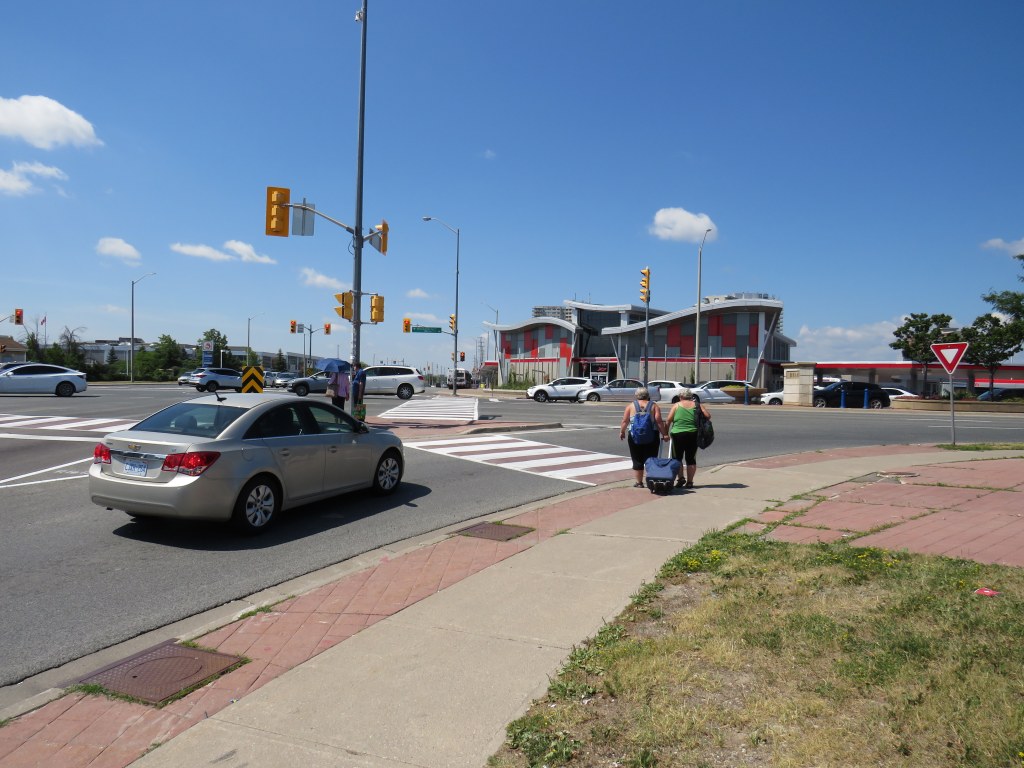
The intersection of Steeles Avenue and Main and Hurontario Streets
Last year, I wrote about a foreseeable problem coming to the corner of Steeles Avenue and Hurontario and Main Streets in Brampton: the planned Hurontario LRT terminus, to be located on the south side of Steeles Avenue, would require thousands of commuters to transfer to Brampton Transit buses on the north-west corner of the intersection.
This transfer would require crossing ten or eleven lanes of traffic at one of Peel Region’s busiest intersections, with crowding at the street corners, with passengers awaiting a walk signal two separate times to make the necessary connection.
After twice receiving unsatisfactory answers at a Metrolinx online town hall, and hearing no information about how the crossing at this intersection might be mitigated, on March 9, 2021, I took the step of making an Access to Information Request to Metrolinx under the province’s Freedom of Information and Protection of Privacy Act asking for communications between Metrolinx, the Ministry of Transportation, Mobilinx (the consortium awarded the contract to build and operate the LRT), and the City of Brampton.
I received a package with the requested materials from Metrolinx on July 29, 2021. The request cost me $360.00, plus a $5.00 application fee. Communications from Metrolinx’s privacy officer were professional, friendly, and very helpful.
Through my request that covered the dates December 1, 2018 to March 11, 2021, I obtained several letters from Brampton officials, including City Councillor Gurpreet Singh Dhillon, Director of Transportation Special Projects Chris Duyvestyn, Chief Administrative Officer David Barrick, and Mayor Patrick Brown to Metrolinx and Ministry of Transportation Officials requesting restoration of the north side stop at Steeles Avenue/Brampton Gateway Terminal. I also obtained replies from senior Metrolinx staff, including President and CEO Phil Verster and the Deputy Minister and the Minster of Transportation.
What is the communications reveal is that decisions made during the 2014-2018 term of Brampton Council significantly tied the hands of everyone involved — both at the City of Brampton (which reversed its previous decisions when a new council was elected in October 2018) — and at Metrolinx, which was quickly working towards finalizing the contracts to construct the transit project. Unfortunately, important details, such as the final configuration of the Steeles-Hurontario/Main intersection, remain unknown. Neither Metrolinx nor the Ministry of Transportation, which funds Metrolinx, appear to grasp the problems that will be caused when thousands of commuters have to cross two major streets at an especially busy intersection.
Despite Brampton’s work since December 2018 to move the Brampton Gateway stop back north of Steeles Avenue, including formal requests to Metrolinx and the Ontario Ministry of Transportation (MTO), and despite a similar request from RioCan, owner of the massive Shoppers World Mall property at Main Street and Steeles Avenue, Metrolinx and the province have held firm in their decision.
While Metrolinx and the MTO cite the difficulties of reopening a project which was getting underway, and concerned about setting precedents for other changes to the Hurontario LRT or other transit projects, this would still be a minor change, costing just $15 to $20 million according to a 2020 letter from Metrolinx CEO and President Phil Verster to Brampton Mayor Patrick Brown.
Sadly, transit riders in Brampton – who do not have affluence or political might — have been left in the middle of this political back-and-forth between municipal politicians, the province, and Metrolinx. They will be forced to endure a more difficult transfer between LRT and bus than anything proposed to them in public consultations.
Brampton Gateway Terminal from the southeast corner of Hurontario Street and Steeles Avenue, Brampton
Last month, Metrolinx held a virtual open house to present information on the progress of the Hurontario LRT project, planned work, and details on some of the stops along the line. For now, roadwork is limited to median removal and utility relocation, but by next year, heavy construction will commence along the 18-kilometre long corridor.
If Metrolinx goes ahead with their plans for a minimal station on the south side of the intersection, anyone connecting between modes will be forced to cross two sides of a busy, hazardous intersection at grade, impacting both accessibility and safety. We can thank politicians on the 2014-2018 Brampton City Council for this situation, which provide just one of many examples of how systemic racism manifests in transit decision making.
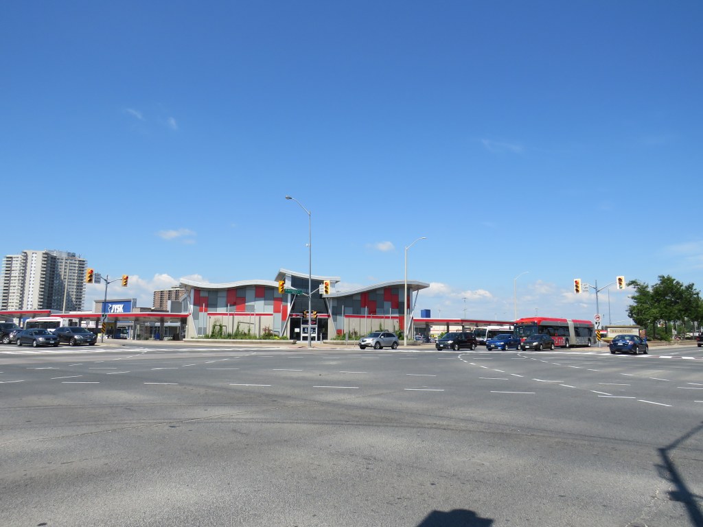
An old Target shopping cart sits in front of Shoppers World. Target, which closed in 2015, now subdivided into smaller retail units, including JYSK, Staples, and Giant Tiger
Previously on this blog, I wrote about Shoppers World Brampton, a shopping mall that slowly declined despite being located in a high-growth suburban city. I wrote that RioCan Real Estate Investment Trust (REIT), the owners of the mall, were interested in developing the property by reducing the retail footprint and adding new residential uses. Some of those details have now been revealed.
Shoppers World opened in 1969, on the outskirts of the Town of Brampton, which was transitioning from a county service centre and industrial town to a suburb of Toronto. The mall expanded twice: once in 1973-74, and again in 1980-81.
In the 1980s, Shoppers World boasted a Simpson’s department store, K-Mart, two full-service supermarkets, a Pascal’s department store, two movie theatres, and even an indoor waterpark. Familiar national chains filled the halls: Thrifty’s, Grand & Toy, Coles and W.H. Smith, Smart Set, Naturalizer, Black’s, Collegiate Sports, Peoples Jewelers, and Reitman’s. Shoppers World never had the status that Square One or Yorkdale enjoyed, but it was a good mall offering just about anything you’d ever need.
It was where I got my first paying gig: returning stray shopping carts to K-Mart for a few dollars apiece. I lived within walking distance of the mall, though I joked that the best thing about it was the bus to Square One.
But many of those national retailers left by the mid-1990s. Square One, a 15 minute drive south, was expanding, and Bramalea City Centre had renovated and expanded as well. But when RioCan REIT purchased Shoppers World in the late 1990s, it made some long-needed improvements, including new flooring over the old terrazzo, a new food court, and removing some of the dead retail space for new big-box retailers like Canadian Tire, Staples, and Winners. When The Bay (successor to Simpson’s) closed, it was replaced by more exterior retail.
Meanwhile, Zellers replaced K-Mart, and briefly became a Target store during the American company’s disastrous foray in the Canadian market. Rio-Can carved that into spaces for smaller retailers, including Giant Tiger. Finally, the bus terminal moved, from a distant corner facing Steeles Avenue, to a central location right at the corner of Main Street and Steeles Avenue, designed for easy transfers to the Hurontario LRT.
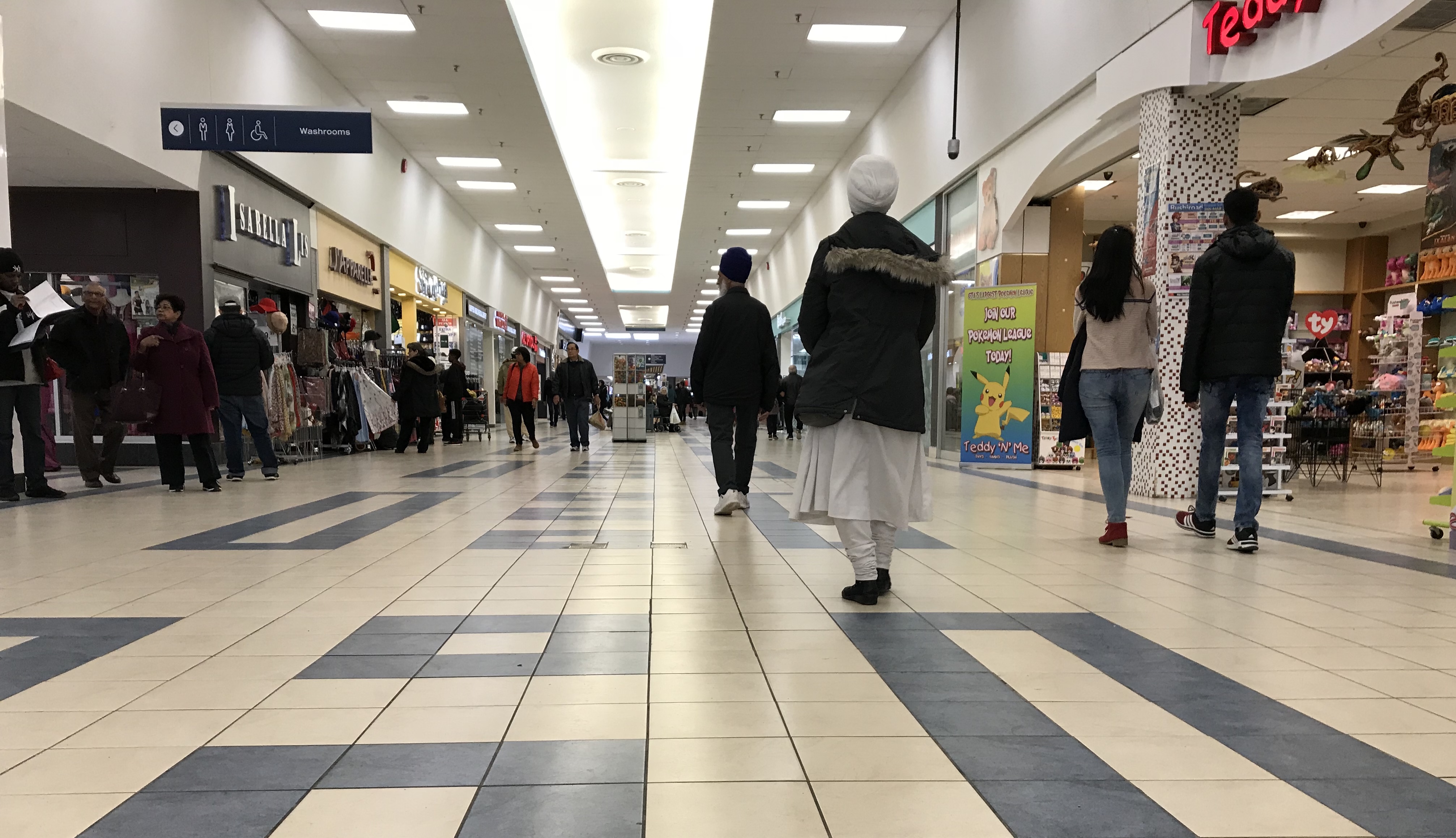
The interior of the mall is still busy, but nearly all chains let their leases expire, with independent retailers taking over. Even so, there are many vacant storefronts.
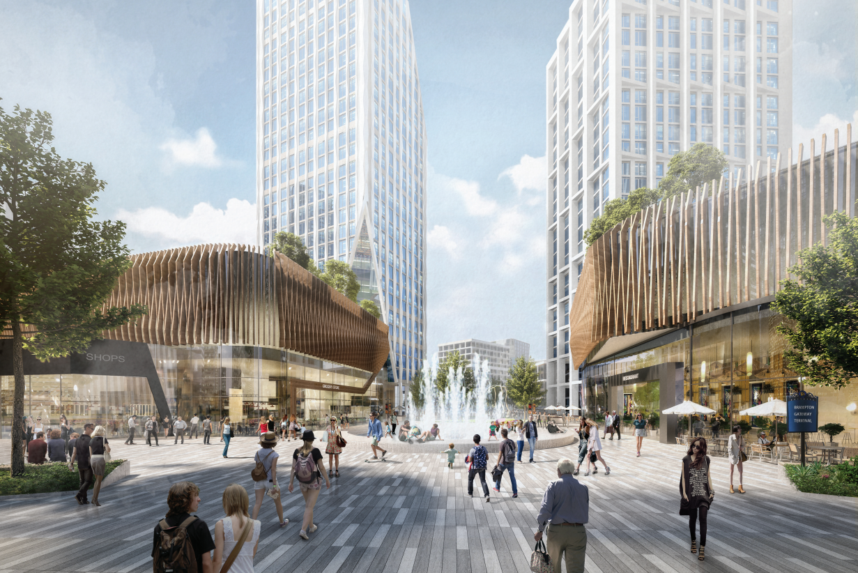
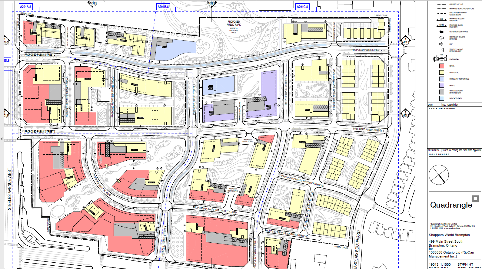
Earlier in October, RioCan submitted their plans to the City of Brampton, and were also presented at an open house at the mall on October 22, 2019. The redevelopment proposal includes new roads, residential towers with at-grade retail, underground parking, among other features.
Details from RioCan’s submission include:
Four new north-south and east-west public streets through the property, including multi-use paths, as several private laneways. Mill Street would continue south from Charolais Boulevard to Steeles Avenue.
New residential towers up to 28 storeys tall, containing 4,725 units (one, two, and potentially three-bedroom apartments)
155 townhouses in the northern end of the property, towards low-rise subdivisons north of Charolais Boulevard
44,647 m² (480,582 sq. ft.) of retail space integrated with the residential towers, a reduction from 62,256 m² (670,124 sq. ft.)
An enlarged Kaneff Park (west of the mall, between two separate existing high-rise rental tower clusters), along with new community and library space
New office space adjacent to the expanded park and community space
Most parking will be located underground
The Brampton Gateway terminal will remain
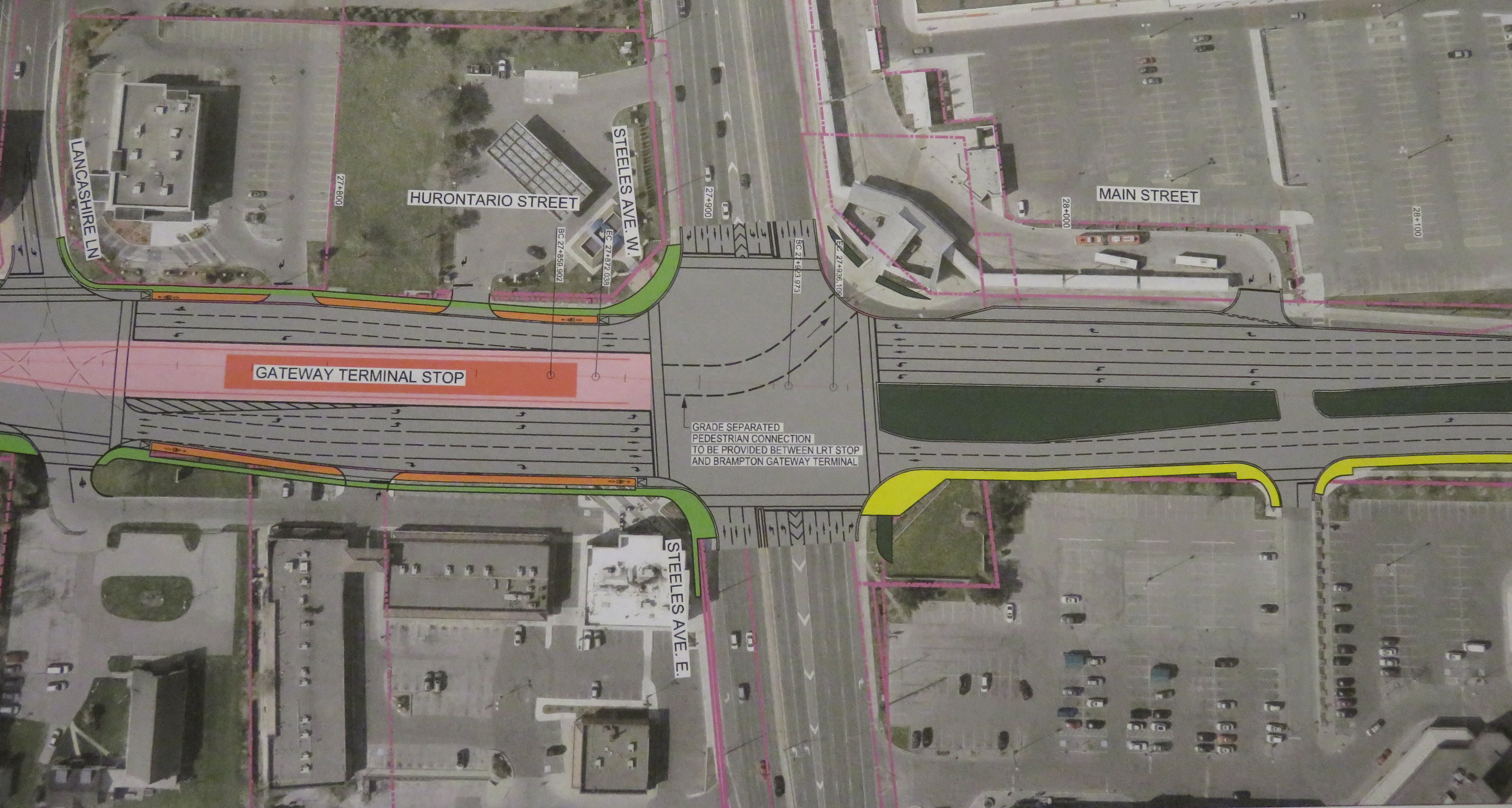
Site plan from RioCan’s submissions to the City of Brampton. Click to enlarge.
The first phase of the redevelopment will be 27-storey tower on the southwest corner of the site (where the abandoned Brampton Transit terminal now sits). This will be constructed before the mall itself is touched. Further phases will see the mall slowly demolished, though they are dependent on market conditions.
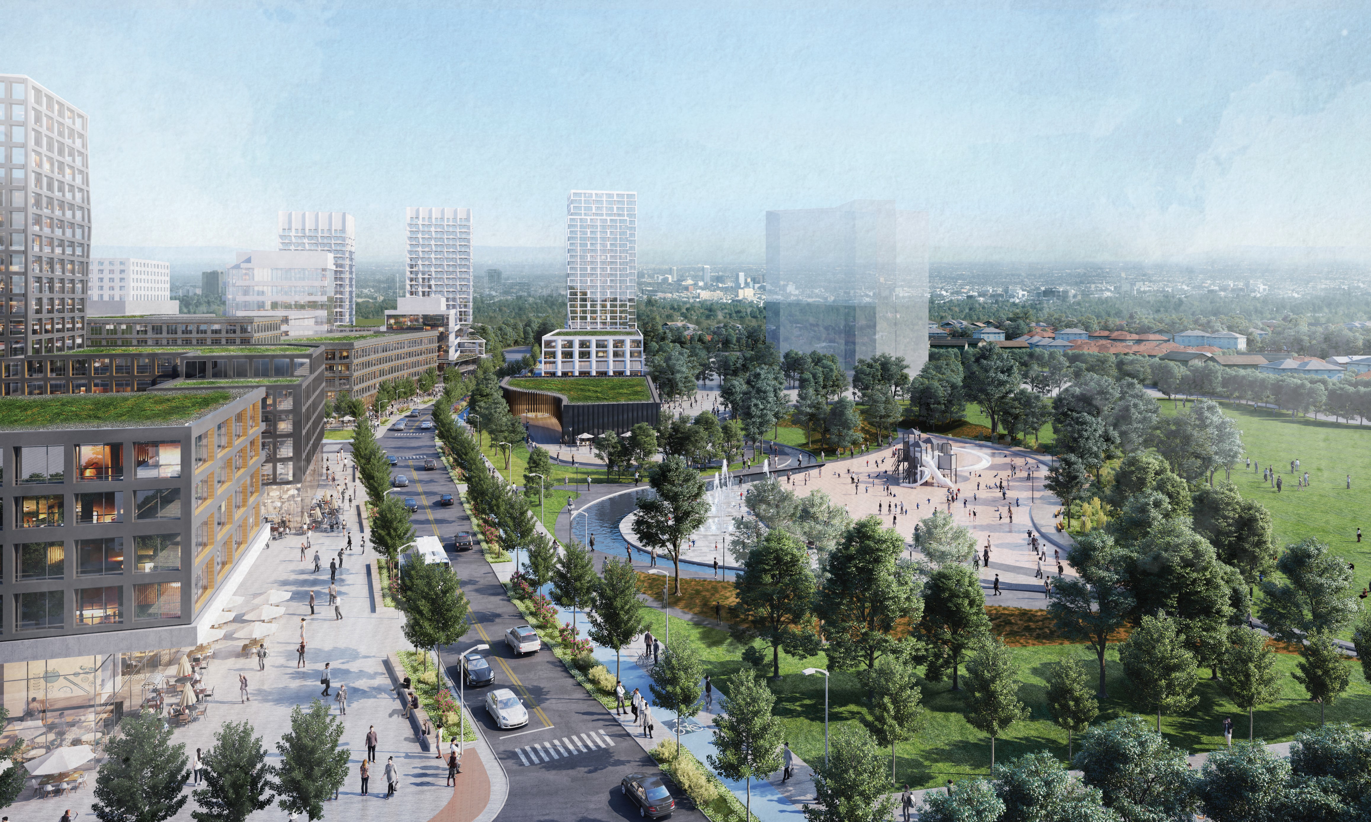
Rendering of Shoppers World redevelopment, looking northwest from the existing Brampton Gateway Terminal
RioCan hired Quadrangle and SvN architects to develop conceptual renderings for the development, indicating that RioCan is serious about this development. Given the City of Brampton’s own plans for urbanizing this part of the city, I am optimistic this will be built. The area already has good public transit access, with Zum express bus service to Downtown Brampton, Mississauga City Centre, Sheridan and Humber Colleges, as well as local service. This will also be at the terminus of the Hurontario LRT line (construction will begin shortly as the contract was just awarded), which may yet continue to Downtown Brampton.
This is the largest shopping mall redevelopment in the Greater Toronto Area, following work now underway at the Galleria Mall in Toronto, and proposed for the Promenade Mall in Vaughan (though much of that mall’s structure will remain intact). As the mid-market gets squeezed by discounters, internet shopping, and high-end shopping centres, more malls of Shoppers World’s size will see similar development.
I was surprised to see such urbanity proposed for suburban Brampton, but it may finally be the time for the Flower City to bloom. Despite my nostalgia for Shoppers World, I am excited for its future.
Looking south on Mill Street towards the park expansion and Steeles Avenue. The first phase tower is shown in the middle background.
Metrolinx light rail vehicle mock-up at Gage Park, meets a Brampton Transit Zum bus, 2013.
Earlier this week, I visited Brampton City Hall, where at a public open house, Metrolinx and city staff provided an update of the Hurontario Light Rail Transit project. Brampton City Hall was an ironic location for the open house; before Brampton Council voted against building the LRT up to Downtown Brampton and the GO/VIA Station, the LRT line would have stopped right here. Even with Brampton’s decision, there will be three stops in the city, so an open house for local residents to provide their feedback was still needed.
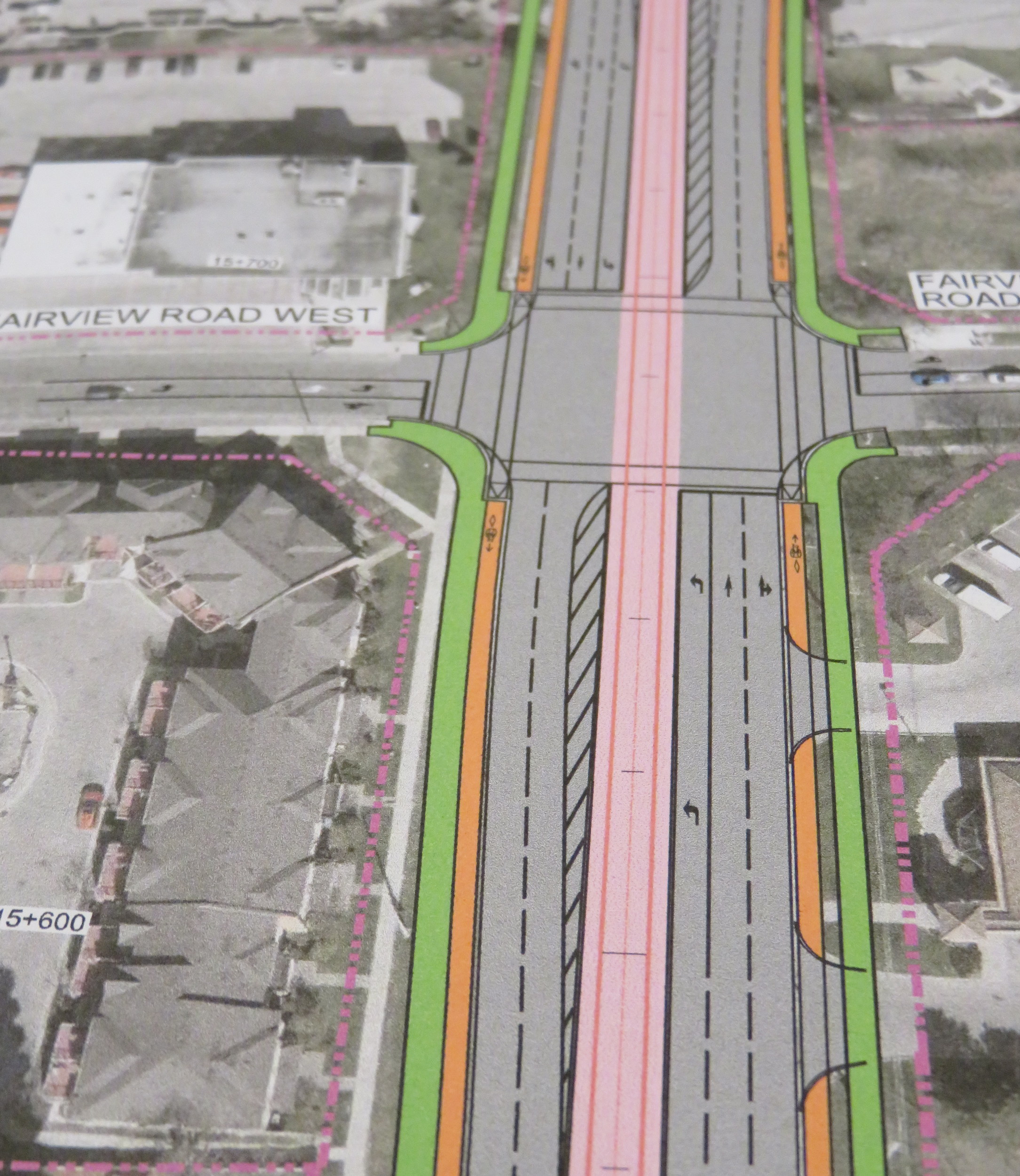
The open house was quite interesting as more design details were displayed. There`s a focus on promoting active transportation — walking and cycling — and urbanizing much of the corridor. Three lanes of motor traffic will go down to two in most places, and right turning traffic will be tamed. This will make Hurontario Street a safer and more pleasant place to be.
Along the entire LRT corridor, Hurontario Street will feature separated bike infrastructure — for the most part, there will be separated bike lanes, with multi-use paths in a few areas, especially south of the Queensway, where Hurontario Street is narrower. Sidewalks are also wider. With only a few exceptions, cyclists will be able to ride across intersections without being required to dismount. Those exceptions are at the Queen Elizabeth Way, and at Highways 403 and 407, where Ministry of Transportation Ontario (MTO) standards at interchanges will force the “stop, dismount, wait for gap” regime; pedestrians will also still have to yield to motor traffic.
Typical cross-section once the LRT is built. The orange paths are the separated bike lanes, the green paths are sidewalks. Hurontario Street will only have two traffic lanes in each direction.
At expressways, like at Highway 407, pedestrians and cyclists still must yield to motor traffic at on-ramps.
In another benefit for pedestrians and cyclists, channelized right turns are eliminated along the entire route. Channelized right turns (like the one shown below) are convenient for motorists, but they increase conflicts with foot traffic and are incompatible with lower speeds and safe cycling infrastructure. Their removal also creates new room for streetscaping opportunities.
An example of a channelized right turn
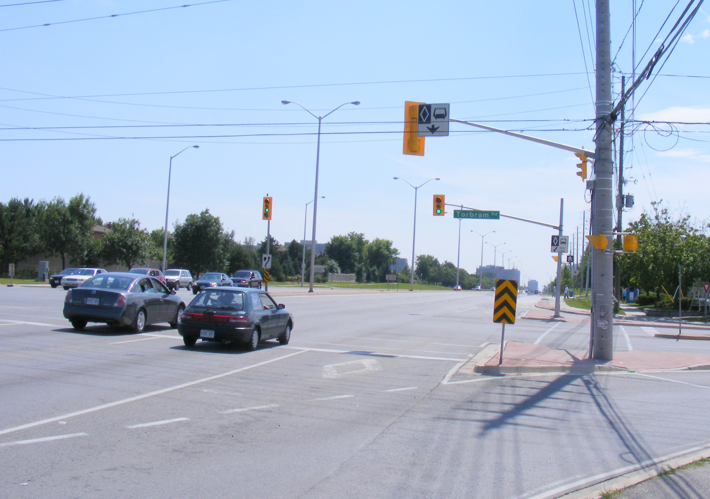
The northern terminus of the LRT, at least for now, will be at Steeles Avenue. As Brampton debates other LRT alignments (Kennedy Road and McLauglin Road are indirect alternatives to reach Downtown Brampton), the stop was moved to the south side of the intersection. This is unfortunate: the Brampton Gateway bus terminal, which opened in 2012, was designed to easily connect with the planned LRT stop on the north side of the intersection, with two short crosswalks across southbound Main Street.
Planned LRT terminus at Steeles Avenue, including tunnel between the LRT platform and the Brampton Gateway Terminal.
Instead, a more expensive tunnel is required to accommodate transferring passengers between the LRT and buses. Elevators and escalators will provide direct access to the tunnel; crosswalks at Steeles Avenue and Lancashire Lane will also be accessible from the platform.
The final contract is planned to be signed in mid-2018 and construction should begin in Fall 2018. As the City of Mississauga backs the LRT project, hopefully any change in the provincial government will not jeopardize this plan. Not only will Mississauga (and south Brampton) get a fine new transit service, it will also see a tamer, more urbanized main street.
And maybe Brampton City Council will come to its senses and extend the transit corridor via the direct, least-expensive, Main Street alignment.


 Looking south on Mill Street towards the park expansion and Steeles Avenue. The first phase tower is shown in the middle background.
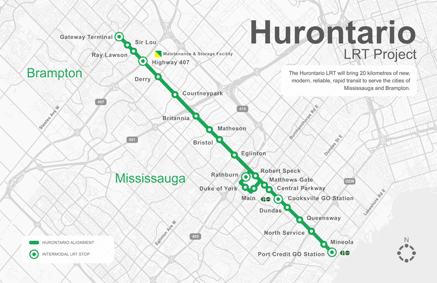
 Typical cross-section once the LRT is built. The orange paths are the separated bike lanes, the green paths are sidewalks. Hurontario Street will only have two traffic lanes in each direction.
 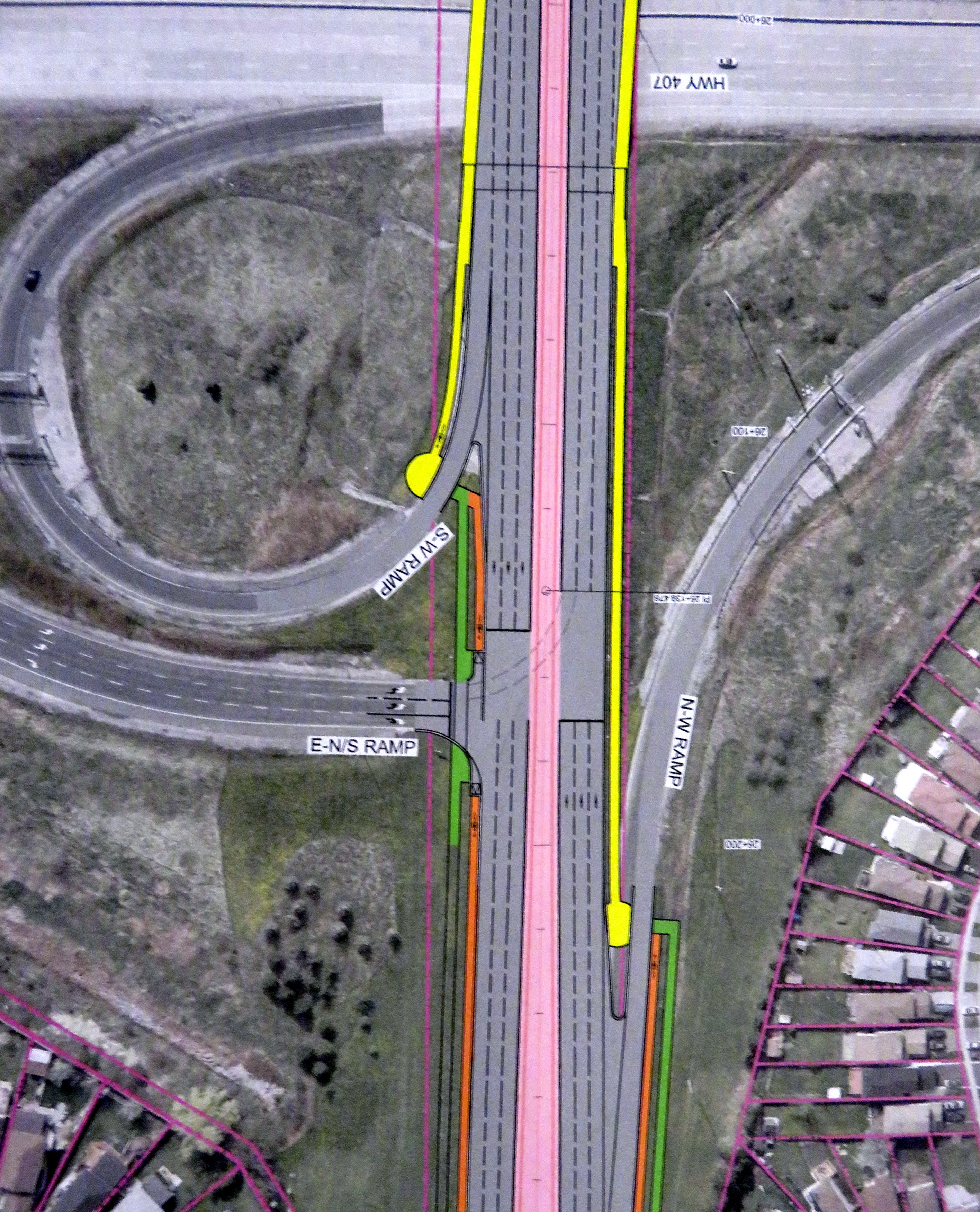 At expressways, like at Highway 407, pedestrians and cyclists still must yield to motor traffic at on-ramps.