Last month, I wrote about the challenges getting around Toronto’s Union Station, Canada’s busiest transportation hub, particularly for passengers using mobility devices or carrying luggage. Only one poorly-marked elevator directly links the Great Hall and the UP Express platform with the subway station/PATH level, which is located two floors down.
I returned to Union Station on Tuesday, January 7, to see if any improvements were made since I wrote my initial post. Somewhat surprisingly, new signs were installed beside the elevators, indicating which floor goes where.
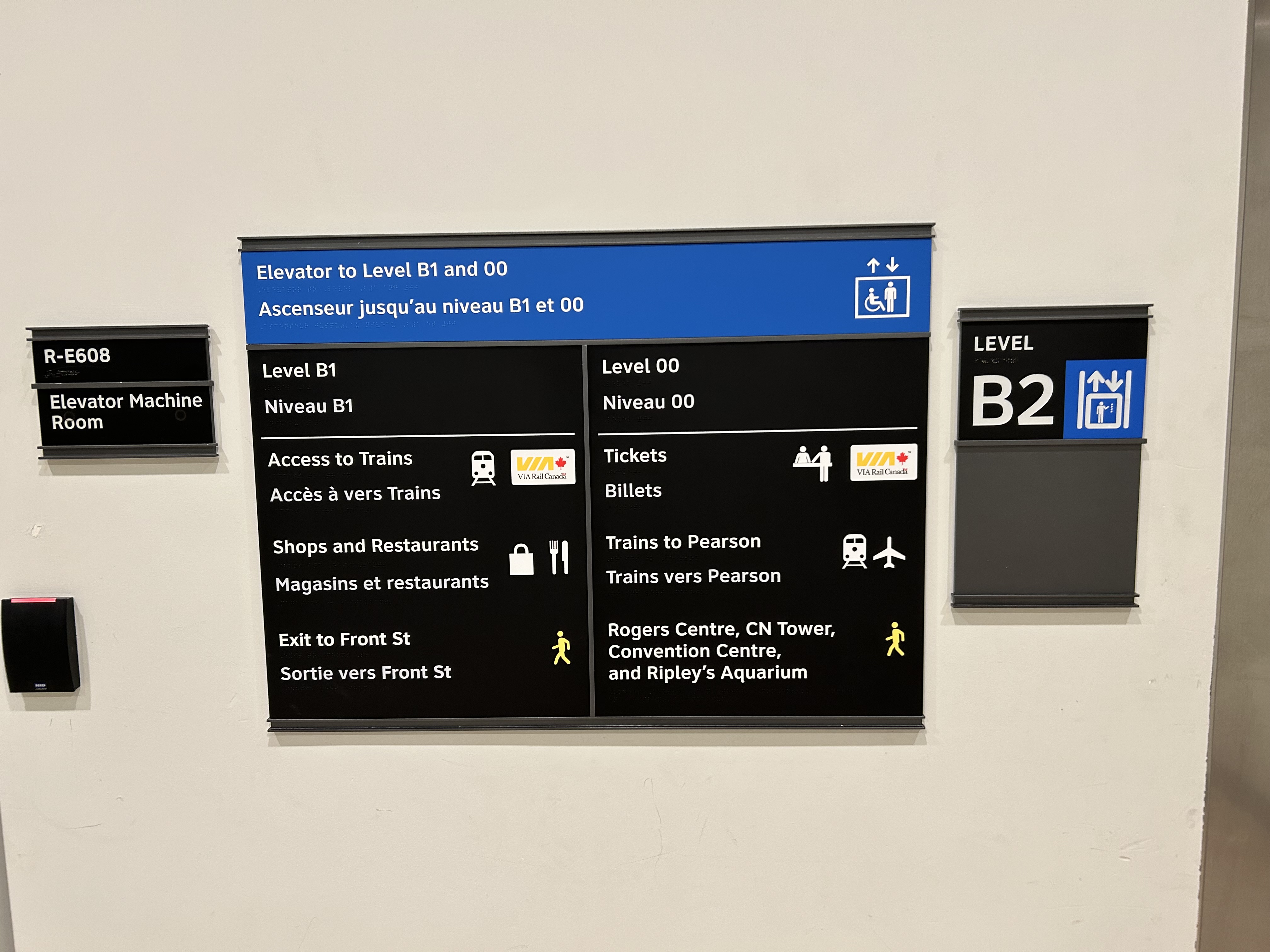
Elevator signage at B2 level (subway concourse/PATH level by Bay Street) that indicates where the other floors lead to: Level B1 for VIA trains, shops and restaurants, and exit to Front Street, and Level 00 for VIA ticketing, UP Express trains, and access to the Skywalk to Rogers Centre, CN Tower et al.In the GO York Concourse, the elevator leads to Level 00 (The Great Hall) only.
These signs are a notable improvement, but there is still no signage inside the elevator cars themselves, so the traveler must note the directory signage before entering the elevator. Furthermore, the Great Hall, the historic centrepiece of the Union Station complex, is not noted, even though it is a logical meeting place from where access to all GO, VIA, and UP Express train services can be made, or where taxis can be found right outside.
Unfortunately, the elevators themselves are still difficult to locate, and the decision to have just one slow elevator connect the Great Hall/UP Express floor with the subway station entrance remains unfortunate. There is still so much more to be done.
In the Great Hall, there are clear signs directing passengers towards the subway, but there are no indications on where a barrier-free passage can be found. A supplementary sign pointing towards the one elevator, located at the far end of the Great Hall, could be useful here.
Previously on this website, I discussed the problems with the unsightly, intrusive, and poorly thought-out mess of Jersey barriers plopped in front of Union Station along Front Street. They have not only been an eyesore unbefitting a signature heritage structure, but they have also been difficult for pedestrians to navigate around, especially at the corners of Front and Bay and Front and York.
Inside Union Station, however, a lot has changed in the last few years. In general, pedestrian flow within the station building has improved, especially with the opening of the GO Transit York Concourse, which provides a second access point for regional trains. Flow between subway, train, and shops is considerably improved; there are also a lot more food and retail options befitting a central transport hub.
Despite new escalators and elevators, accessibility in Union Station remains poor. Though technically, the station is fully accessible to anyone using a wheelchair or other mobility device, the wayfinding is absent in key areas. There is only one small elevator that directly connects the subway level with the Great Hall, UP Express trains, and Front Street. An accessible route is also difficult to find.
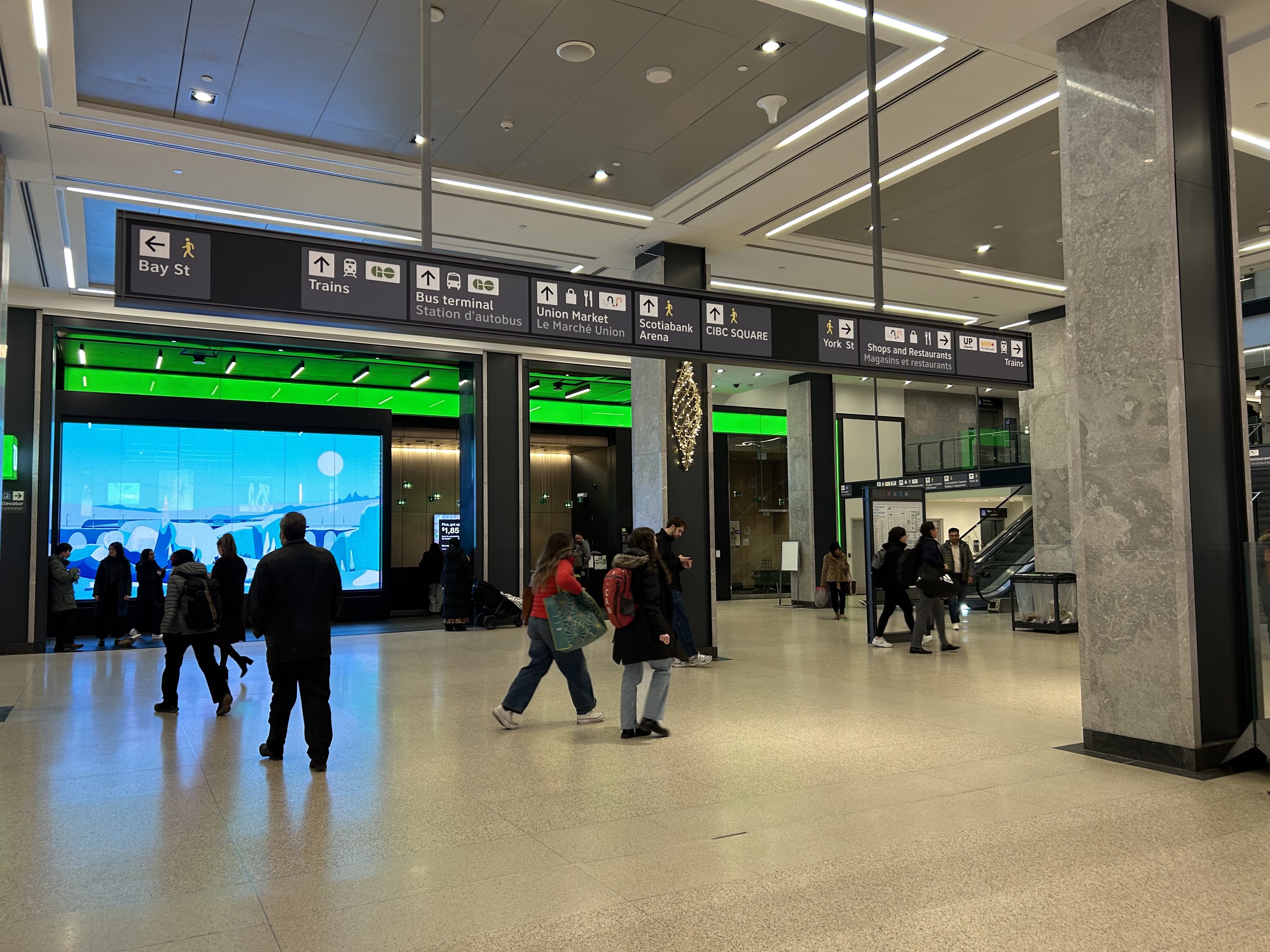
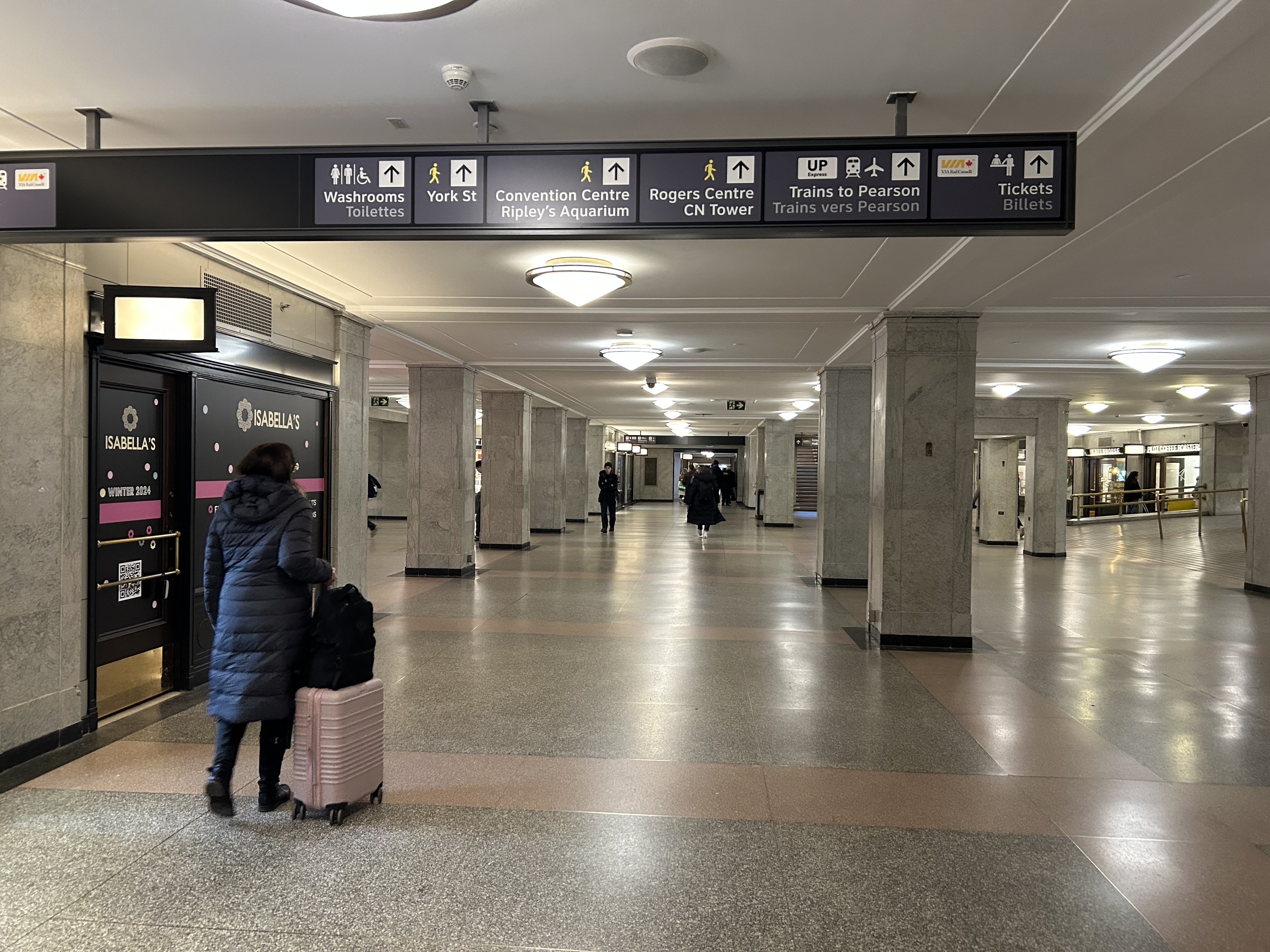
The view after entering the Union Station complex from the TTC subway. The overhead sign shows the way to GO trains, the bus terminal, the Union Market shopping area, Scotiabank Arena, CIBC Square (an office building), York Street, more shops and restaurants, and VIA and UP Express trains.
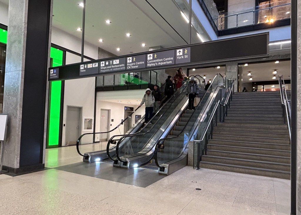
Imagine entering Union Station from the adjacent TTC subway station with a wheeled device or a mobility aid. There is a large concourse with signs leading forward towards the GO Transit York Concourse along with Scotiabank Arena, the bus terminal, and Union Station shops and food kiosks. To the left is Bay Street, and to the right are a set of escalators and stairs leading up towards VIA Rail and UP Express trains. Behind the stairs and escalators is a single elevator, hidden away.
To the right is a set of escalators, stairs, and hidden behind, a poorly marked single elevator.These lead towards UP Express and VIA trains, York Street, and attractions such as the CN Tower, the Convention Centre, and Rogers Centre.
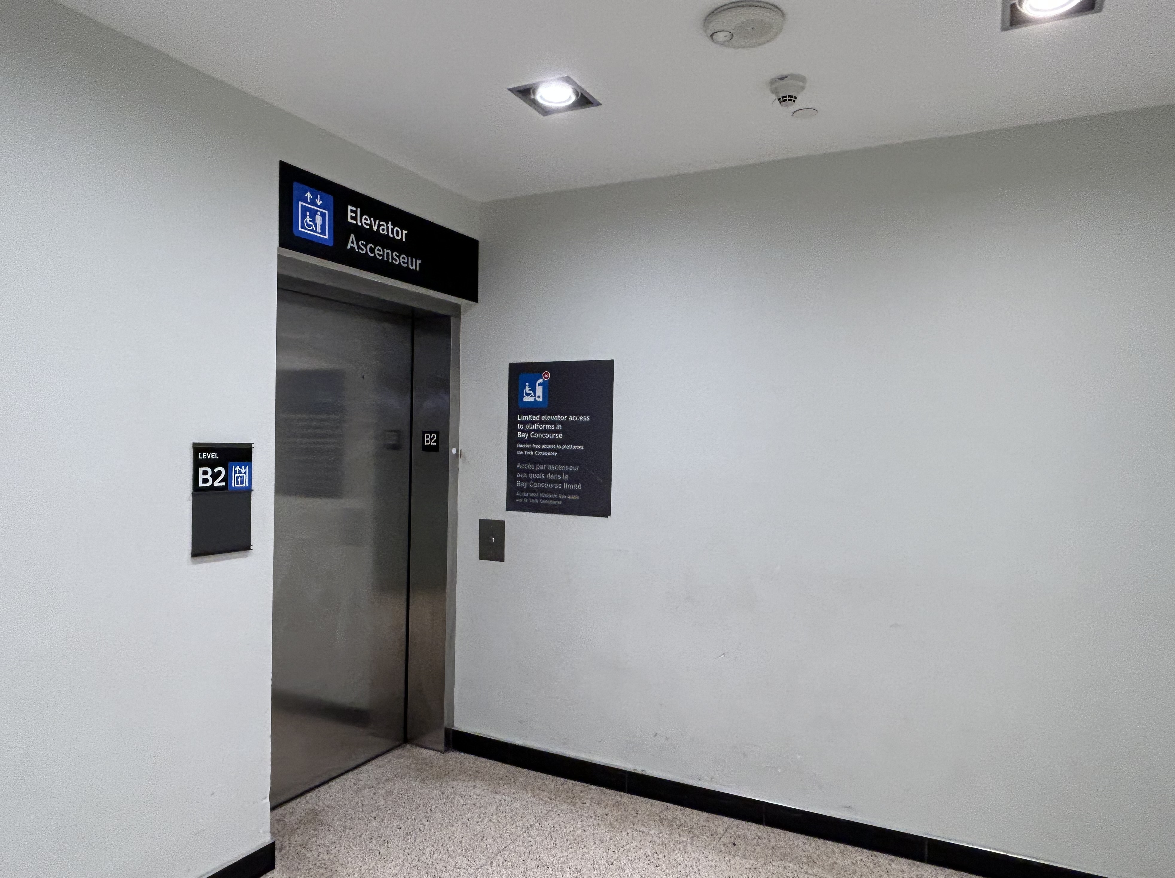
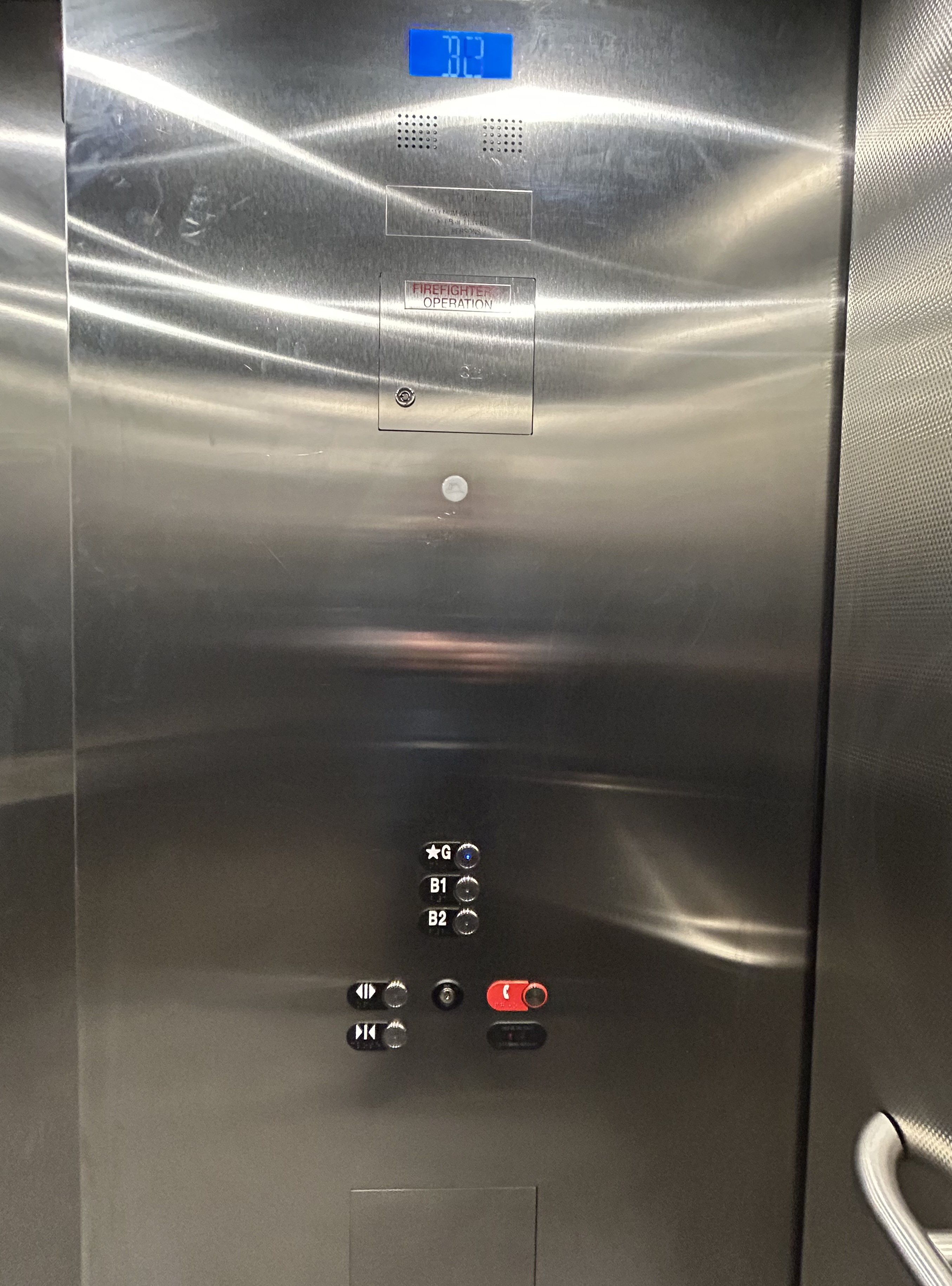
The elevator provides no information other than a sign that indicates that this is, in fact, an elevator, and this is the B2 level. This is a single, small elevator, which operates slowly.
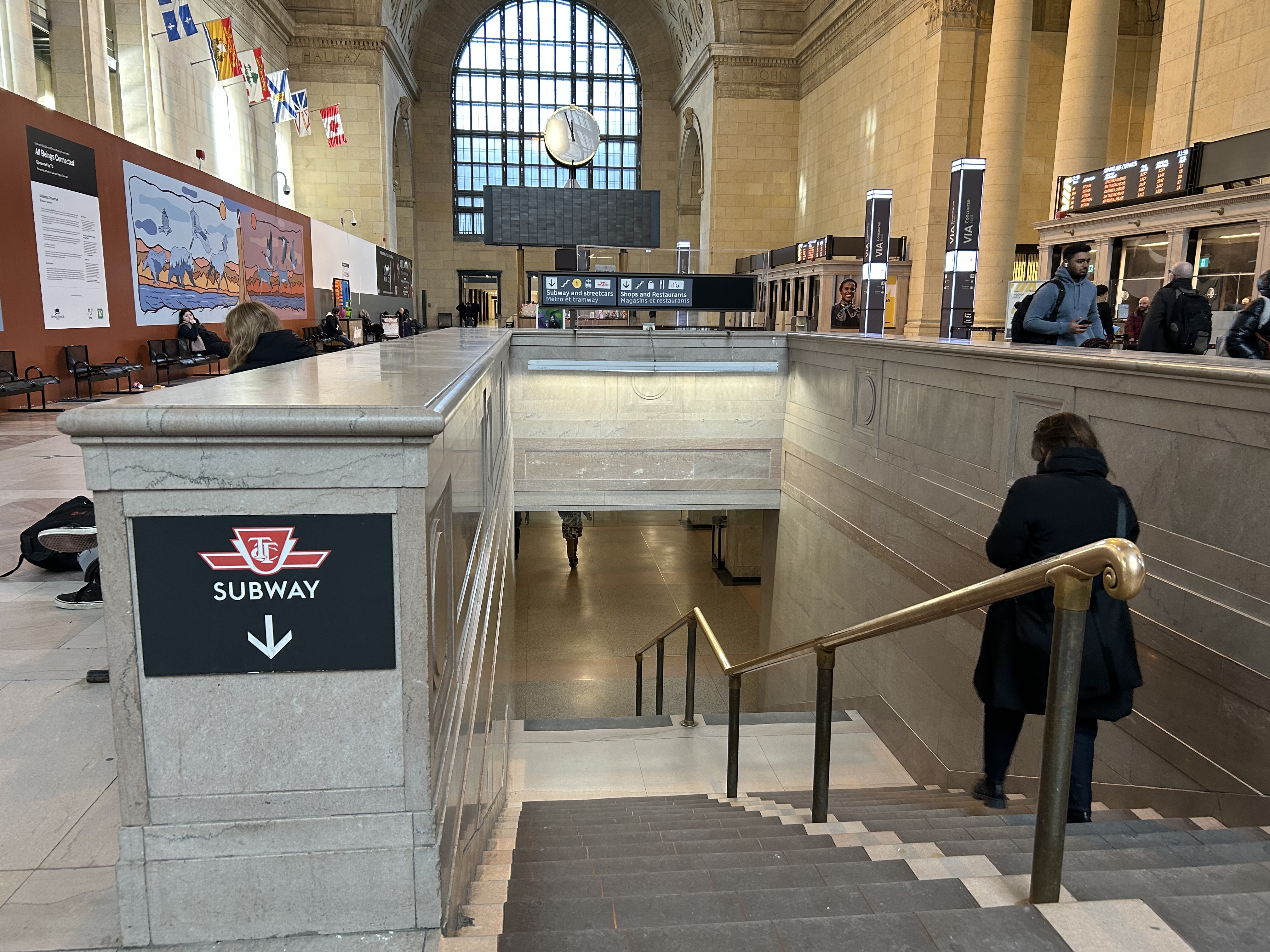
The elevator at the B2 (subway) level
Once inside the elevator, there is no information other than buttons marked “G”, “B1”, and “B2”. There is nothing to tell the elevator user what is accessible from each floor.
Confusingly, the official Union Station map directory calls the three levels “Street Level” (G, the Heritage structure including the Great Hall, West and East Wings, along with the path towards UP Express and the Skywalk), “Lower Level” (B1, the GO York and Bay Concourses, the concourse beneath the Great Hall, and the VIA departure area) and “Retail Level” (B2, including the food court, food hall, and connections to the subway). In the elevators, the audio prompts only mention the three level names.
Inside the elevators, there is no indication what each level is, or where they lead to — the buttons and empty spaces beside them just show G, B1, and B2 levels
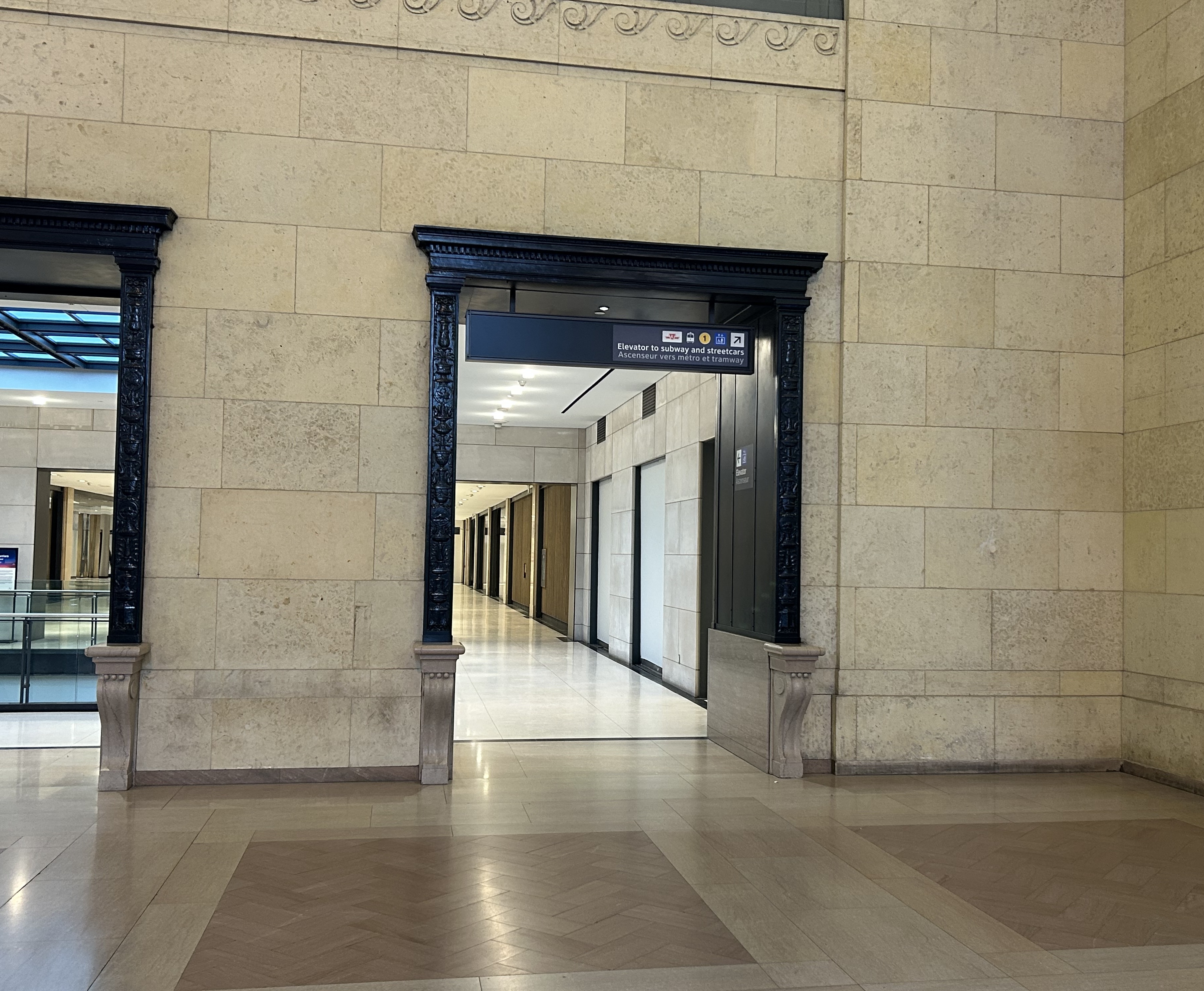
At G level, which includes the Great Hall, VIA Rail departures and business class lounge, and the passage west towards UP Express trains and the Skywalk to the CN Tower and Rogers Centre, the elevator is also hidden behind a wall.
The only elevator connecting the Great Hall, the lower concourse, and the subway level is hidden, with tiny signage directing travelers to it
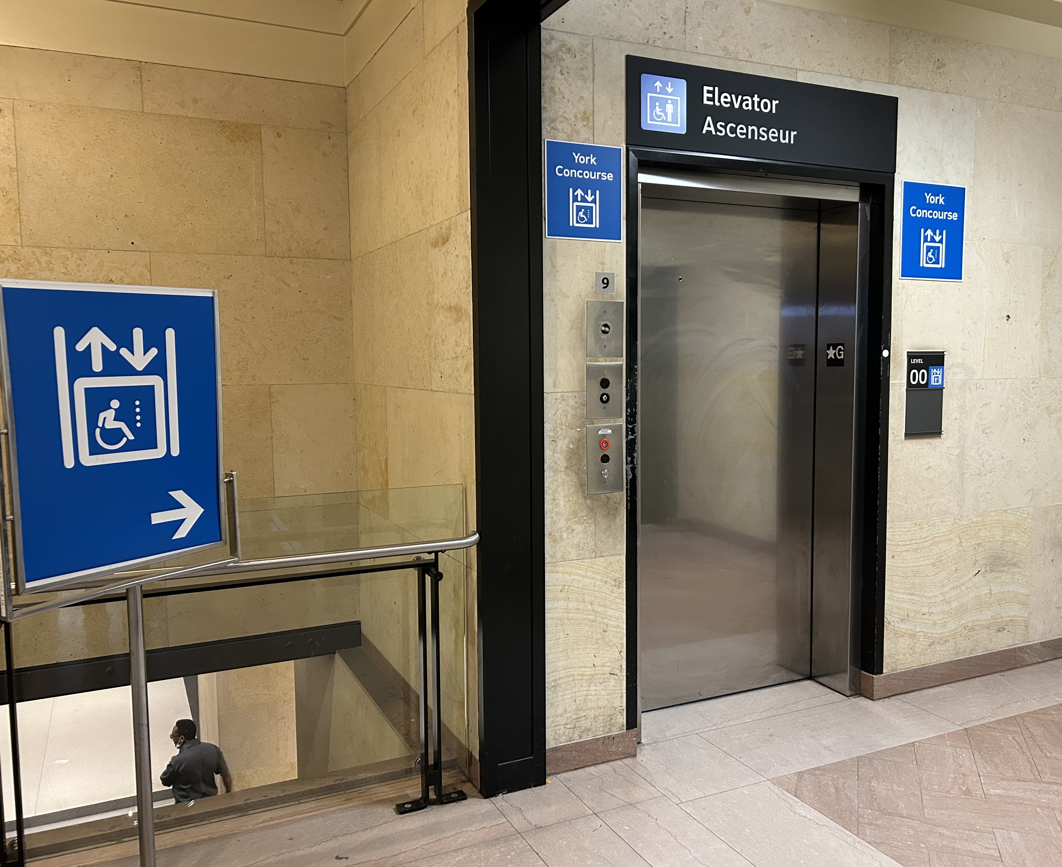
On the west side of The Great Hall, there is also an elevator, beside the stairway down to the GO Transit York Concourse. This elevator does not serve level B2.
York Concourse elevator, on the west side of Union Station’s Great Hall
If the traveler was only connecting from subway to UP Express with a heavy bag, and not using a mobility device, they might decide to take an escalator from the subway B2 level to the B1 level, the lower Union Station concourse originally intended as an arrivals area for intercity trains. However, there is no elevator or upwards escalator to be seen.
Looking west in the lower concourse, towards York Street and UP Express trains
If one knew Union Station well, they could make a lengthy detour through the ramps in the VIA Rail area to get to the Great Hall or go around through the GO York Concourse to reach the elevator or up escalator to the Great Hall. But these routes are not marked from the lower concourse area.
To show how difficult it can be to navigate the station while using a wheeled device (be it a wheelchair, stroller, or wheeled luggage), I shot this video showing how a first-time visitor getting off an UP Express train from Union Station would try to find the TTC subway entrance.
Video depicting 9-minute trip at a normal walking speed between the UP Express area and TTC subway station entrance, using first available elevators each time.
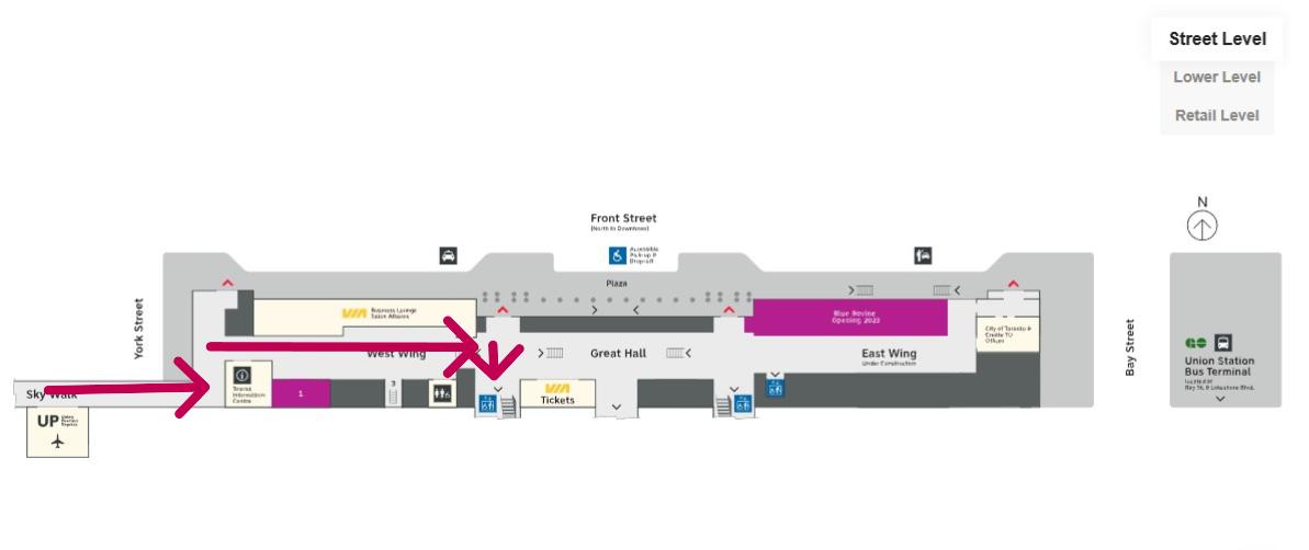
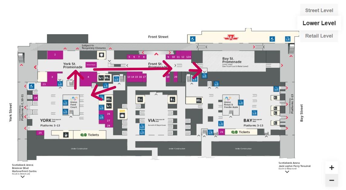
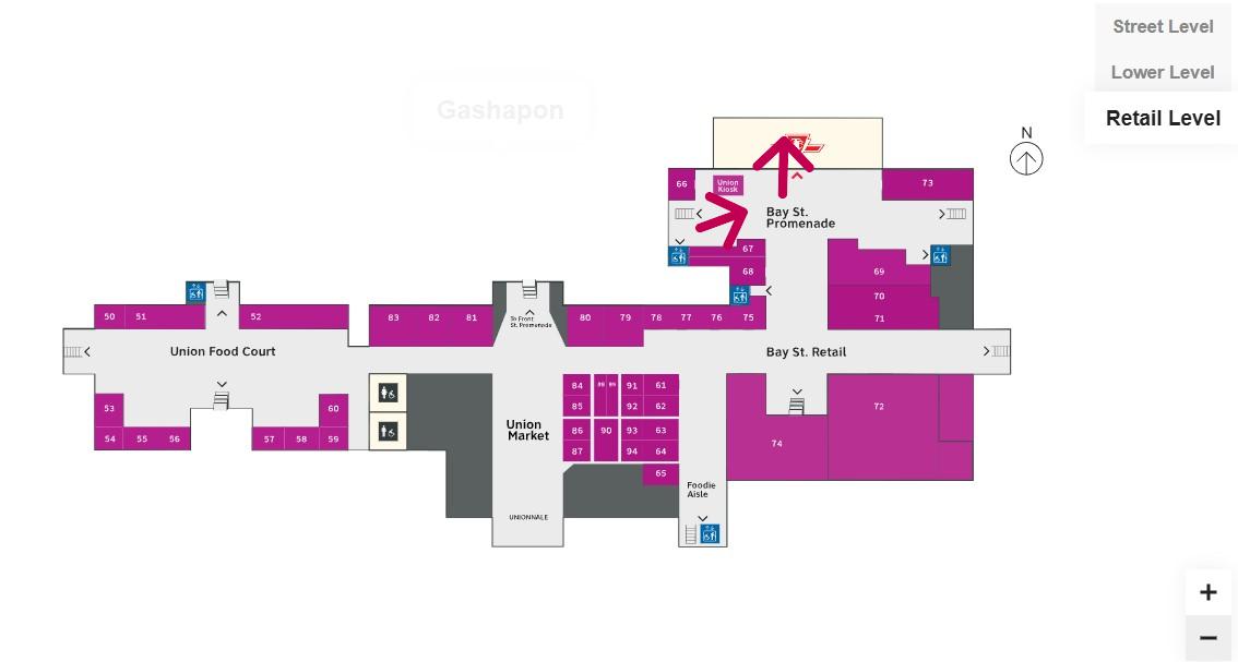
At no point was there any visible signage showing the most direct route for someone requiring a barrier-free path from UP Express to the subway. The maps below show the route I took:
Route from UP Express to the Great Hall and York Concourse Elevator (Street Level, or G). Arrows are added to mark the route I took in the video.Path through York Concourse, lower Union Station concourse (Front St. Promenade) – the B1 Level, and to the second elevator to the Bay St. Promenade (subway level). Arrows are added to mark the route I took in the video.Last part of the trip on the Retail Level (B2) to the subway station entrance. Arrows are added to mark the route I took in the video.
Whenever I travel through an international airport — Toronto Pearson is a good example — I never have to think too hard about where the accessible routes are. Escalators are easy to find. There are banks of two or three large elevators in strategic locations on the ground side of airports, connecting departure and arrival areas, as well as ground transportation facilities. As Canada’s busiest transport hub — busier than Toronto Pearson Airport even — Union Station’s elevators and escalators should be plentiful and easy to find.
I am aware that there are particular challenges at Toronto Union Station — the City of Toronto controls only the common areas, such as the Great Hall, the retail areas, and the main entrances. Metrolinx, the agency responsible for GO Transit and UP Express, controls the York and Bay Concourses, as well as the UP Express station area. VIA Rail maintains its departures area. There are also heritage elements that need to remain intact, such as the Great Hall. But these issues of ownership and heritage preservation do not excuse the difficulty of getting around with a mobility device or even a wheeled bag.
Why weren’t multiple elevators installed connecting all three levels, to improve capacity, speed, and provide redundancy in the case of an elevator outage? Why are there not easy-to-find elevators in the West Wing near the UP Express area?
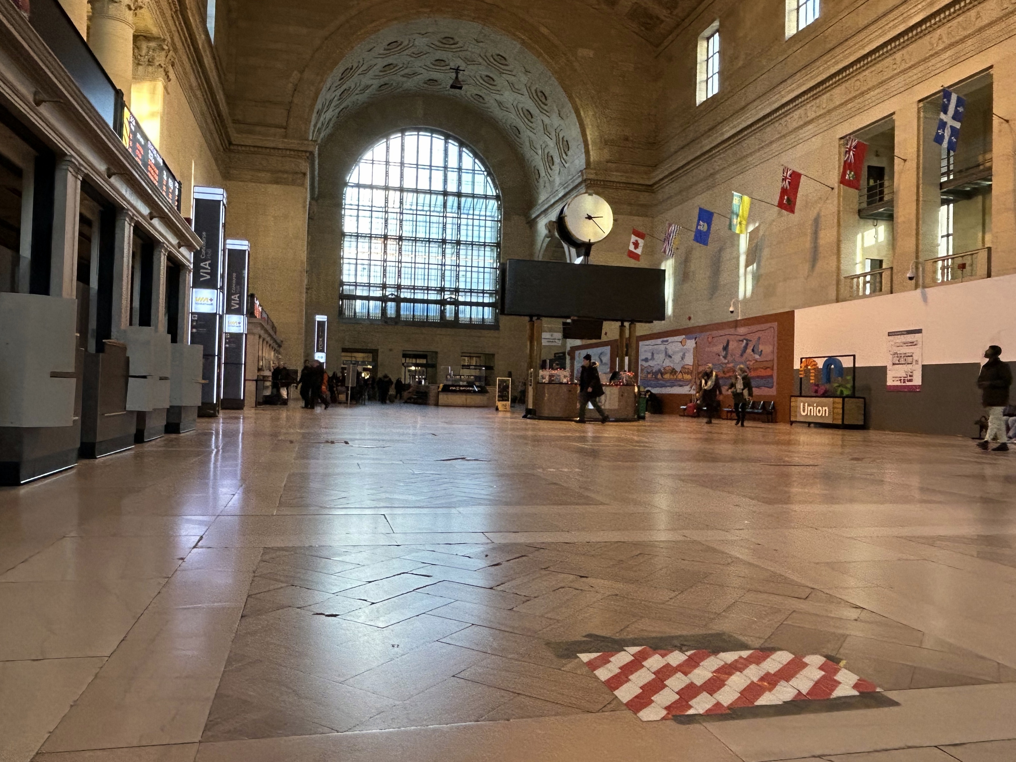
Judging by the condition of the signature Great Hall itself, there is work yet to be done before Union Station is fully restored to its 1920s grandeur. It should not be too hard to improve accessibility and wayfinding as well. Not just for Torontonians, but for international travelers too.
The Great Hall floor is still cracked and patched, with electrical tape covering some of the damaged sections
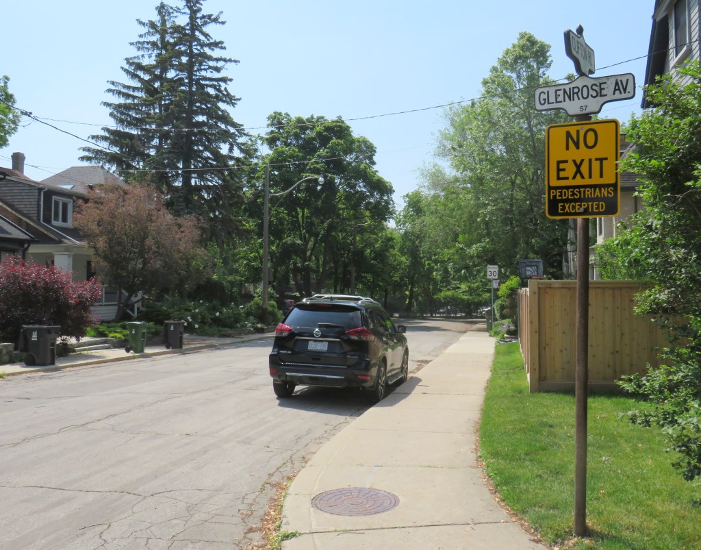
On April 8, Toronto City Council approved a motion brought forward by Councillor Paula Fletcher to change that. Councillor Fletcher’s motion was titled “I’m Walking Here.” Only two months later, new signs are already appearing across Toronto — in Scarborough, Monarch Park, and Swansea. For a city that often takes years to adopt what may seem like simple, easy solutions, this was implemented impressively quickly. The new signs look like standard yellow “no exit” signs, but with a “pedestrians excepted” note at the bottom.
My hope is that these signs will entice Torontonians to get outside, go for a walk, and check out some new streets and parks, enticed by these signs inviting through passage.
In related news, this week Toronto Council approved the expansion of sidewalk slow clearance to all of Toronto’s streets, a service that was previously provided only to suburban areas, where unobstructed sidewalks made municipal slow clearance easy to do. With new snow equipment able to navigate narrow urban sidewalks, Toronto is now finally able to provide universal snow clearance services, a boon for full accessibility.
As public health restrictions ease and stores and restaurant patios reopen this Friday (supported by the city’s willingness to reallocate road space on streets like Yonge and Danforth), there’s never been a better time to for a walk.
Eglinton Avenue East near Brimley Road, one of twelve Seniors Safety Zones in the City of Toronto
Despite its status as a global city, a city that’s often ranked as one of the world’s safest, a city that likes to think of itself as both progressive and a top place to do business, Toronto does a lousy job of protecting its residents from injury and death on its roads.
Although there have been a few positive steps — the new King Street Pilot, launched last week, or the Bloor Street bike lanes, made permanent between Avenue Road and Shaw Street in October — Toronto does far too little to protect pedestrians and cyclists in this city. The installation of sidewalks in residential neighbourhoods are often opposed by local residents resistant to losing driveway space on which to park their cars, or unhappy about having to clear sidewalks of snow and ice. Affluent neighbourhoods might be dotted with “drive slow – kids at play” lawn signs, but their residents and elected representatives will oppose new bike lanes and lower speed limits on the arterial roads they use to commute downtown.
The general idea of reducing road violence is a popular one. But specific actions are often opposed. The city’s own Vision Zero strategy — weak as it is — is a good indication of the ambivalence to road safety we have in this city.
Woman and young child cross seven lanes of traffic at a crosswalk at Eglinton Avenue East and Danforth Road
Vision Zero, which originated in Sweden, is the road safety philosophy that no loss of life is acceptable, and that all road users are human, that humans make mistakes, and road design must minimize the impacts of those mistakes. Complete streets that accommodate all road users (pedestrians, cyclists, motorists, and transit users), and road engineering measures to protect pedestrians and cyclists and reduce traffic speeds are in the spirit of Vision Zero.
But when Mayor John Tory and Public Works and Infrastructure Committee Chair Jaye Robinson (Councillor, Ward 25) originally announced the city’s Vision Zero plan in June 2016, it merely aimed to reduce serious collisions involving pedestrians and cyclists by 20 per cent over a ten year period, allocating $68.1 million over five years. The plan itself was modest. After a social media backlash and criticisms from active transportation activists (including Walk Toronto, of which I am a co-founder and a steering Committee member), the plan was revised, with an additional $10 million allocated and the goal to eliminate serious collisions, rather than simply reduce that number.
One of the specific measures in the city’s Vision Zero plan is the creation of seniors safety zones, areas with high volumes of older adult pedestrians and higher risk of collision. Older adults make up a majority of pedestrian deaths in Toronto; 37 of the 43 pedestrians killed in 2016 were over the age of 55. According to the City of Toronto’s Vision Zero Road Safety Plan, seniors safety zones will feature changes intended to improve pedestrian safety, such as lower speed limits, improved street lighting, advanced and extended walk signals at signalized intersections, red light cameras and radar speed signs, improved sidewalks and additional crosswalks, and increased enforcement.
Twelve seniors safety zones were designated across the entire city of Toronto. Five are in the old City of Toronto, including Dundas Street at Bloor, Dundas at College/Lansdowne, and Dundas at Spadina. Six are in Scarborough, and one is in North York.
Senior Safety Zone sign and 40 km/h speed limit, Danforth Avenue at Coxwell
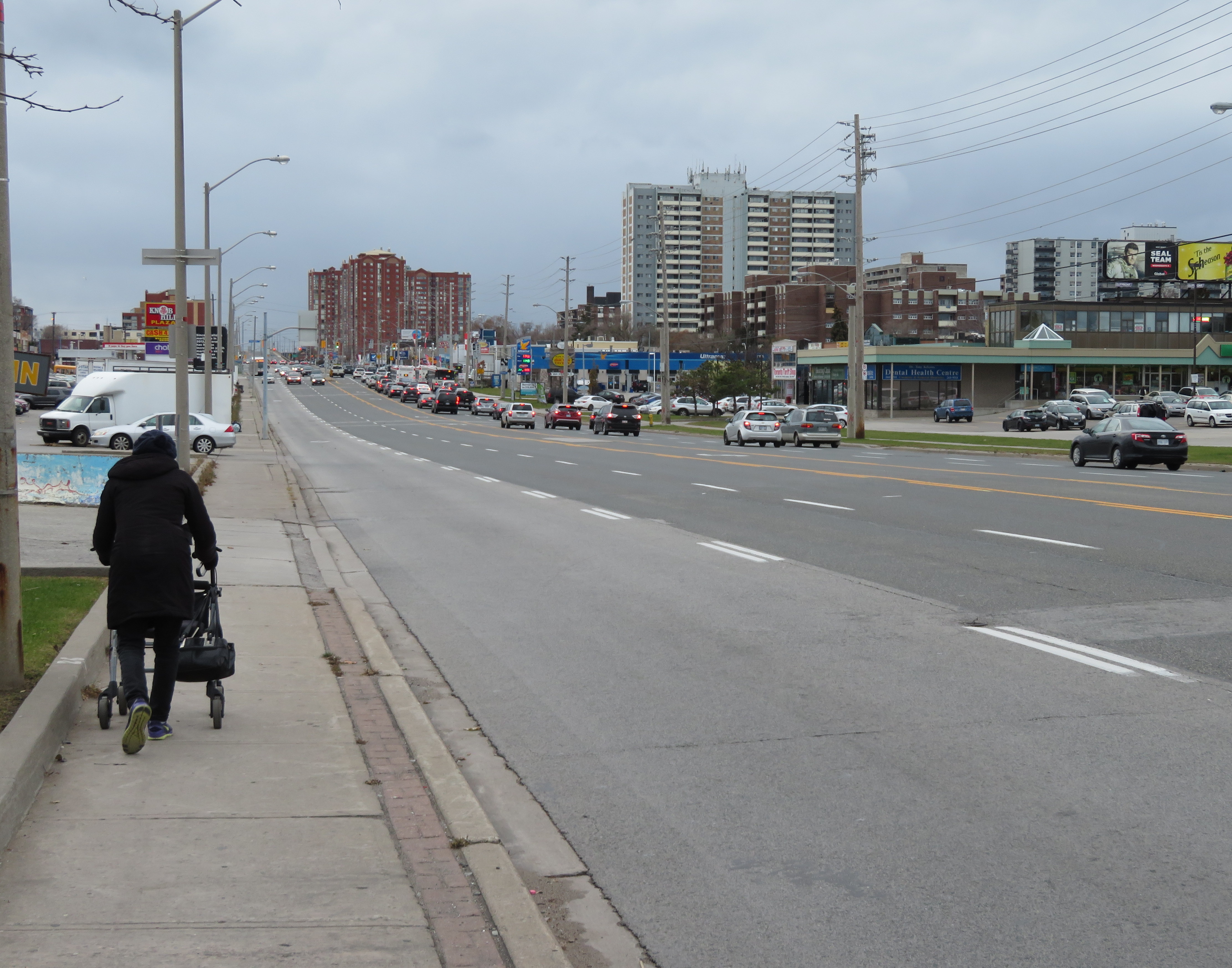
On Danforth Avenue, two senior safety zones were identified: near Coxwell Avenue and near Main Street. The speed limit on Danforth Avenue was reduced from 50 km/h to 40 km/h in 2016, but few other visible changes are apparent. Danforth Avenue is a five lane street, including a centre lane for left turns, and is paralleled by a subway line. The curb lanes on Danforth are unusually wide, and are used for parking outside of weekday rush hours. There are no bike lanes on Danforth either.
Despite the 40 km/h speed limit, the wide lanes, dedicated turning lanes, and the absence of daytime local transit promote high speeds. The design speed of Danforth is simply too high; simply reducing the speed limit and putting up “senior safety zone” signs will do far too little.
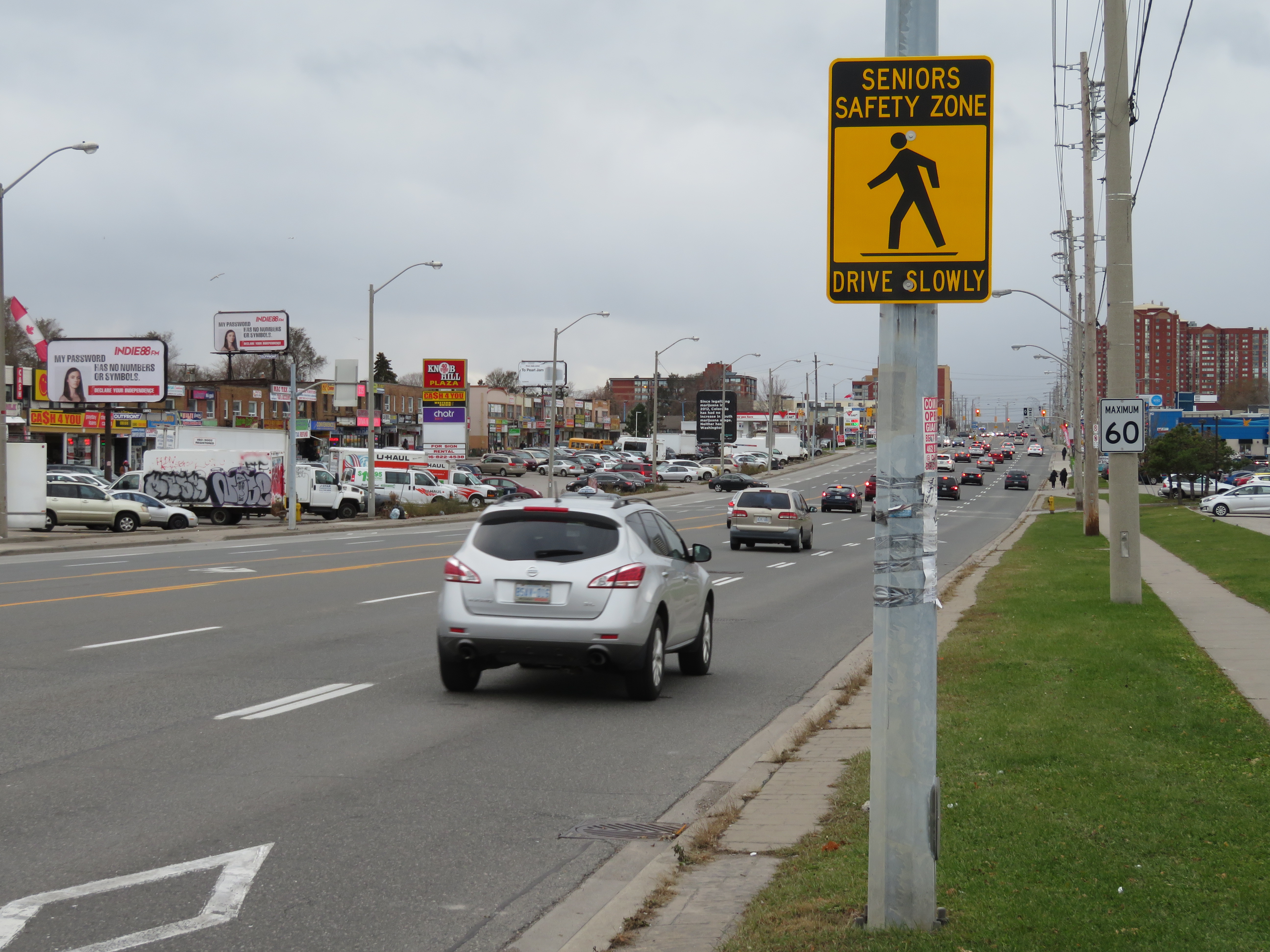
Seniors Safety Zone sign on Eglinton Avenue East, at Brimley Road. Note the 60 km/h speed limit sign
Eglinton Avenue East, between Midland Avenue and Danforth Road in Scarborough, is another senior safety zone. Two pedestrians were killed on this stretch of road in 2016.
Eglinton Avenue through Scarborough is seven lanes wide, including a centre left-turn lane to cross streets and commercial properties that line the wide street. Traffic signals are typically 500 metres apart; many TTC bus stops on Eglinton Avenue East are located far from a designated crosswalk. Buses are frequent between Midland and Brimley; four frequent routes feed into the Kennedy subway station to the west. Again, there is no cycling infrastructure to be found.
The senior safety zone here is a joke. Not one safety intervention was made here. The yellow-and-black safety zone signs that read “drive slowly” are merely advisory, and do not stand out among other traffic and commercial signage. The 60 km/h speed limit was not changed, and intersections were not altered at all to improve pedestrian safety.
At Eglinton and Midland Avenues, wide curb radii encourage speedy right turns into crosswalks; many drivers do not stop at the red light before making a right turn
Several residential side streets off of Eglinton, such as Winter Avenue, do not even feature sidewalks. The signs might say “seniors safety zone” but there is no evidence that pedestrian safety is taken seriously at all here.
Winter Avenue’s sidewalks disappear a mere 50 metres south of Eglinton Avenue
Physical interventions, such as narrower lanes (which could make room for cycling infrastructure and/or wider sidewalks), bump-outs at crosswalks to improve pedestrian visibility and slow down right-turning vehicles, would be more effective. Police enforcement, or speed radar cameras, would be an additional deterrent against dangerous driving.
At least the city has taken notice of the unacceptable numbers of pedestrians and cyclists killed in Toronto, but simply putting up new speed limit and safety zone signs are not enough. Without road engineering works to slow traffic down, and without effective police enforcement against speeding and drivers’ failures to obey traffic signs and yield the right of way to pedestrians, we only get feel-good measures and ineffective signs. A real commitment to Vision Zero requires political will, which so far is lacking at City Hall. Instead, we get zero vision.
Last week in Torontoist, I wrote about the challenges of getting around on the TTC for passengers who rely on mobility devices, such as wheelchairs. Most of us never think about this problem unless we’re directly affected by the consequences of an inadequate system, as I was after a cycling injury in 2012.
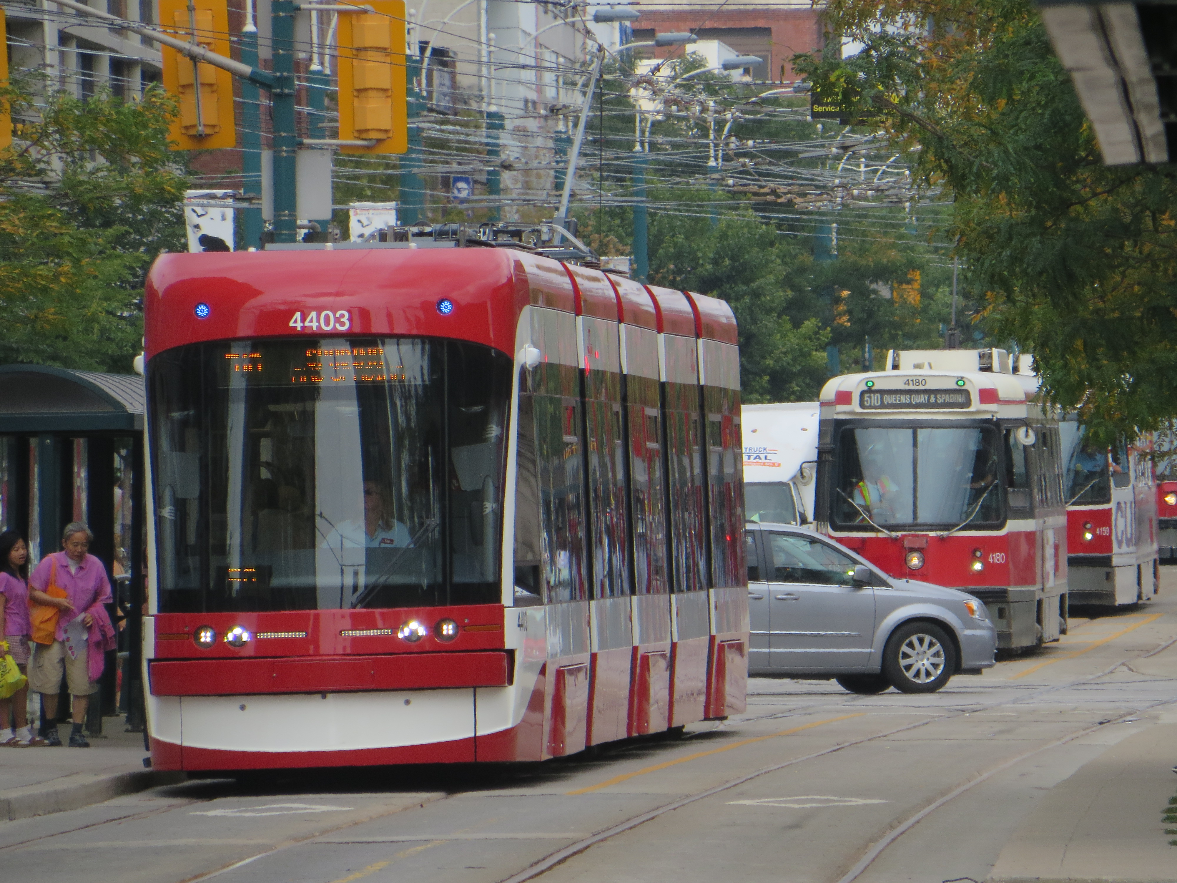
But for TTC users with mobility disabilities (or even passengers with strollers, wheeled carts, or luggage), it’s an issue. While the bus system is (mostly) fully-accessible, the backlog in the delivery of new streetcars and the installation of elevators in subway stations leaves the system failing many of its riders. The alternative, Wheel-Trans, is also underfunded, inconvenient and useless for last-minute travel plans.
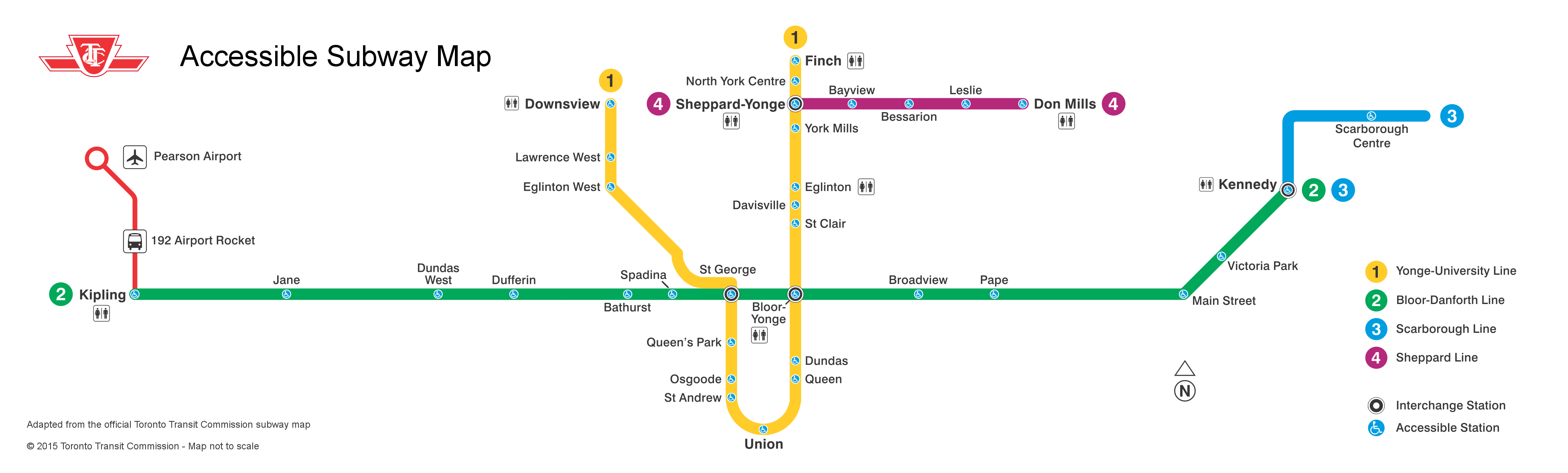
Here’s what the subway system looks like if you require the use of elevators to navigate the system:
By 2016, only one more station — St. Clair West — will be equipped, by 2017, Wilson, Ossington, Coxwell, and Woodbine (and hopefully the Spadina Subway Extension to Vaughan Centre, with its six new fully-accessible stations, will open by then) will follow. But there’s not enough funding to make the entire system accessible by 2025, the deadline set by the Accessibility for Ontarians with Disabilities Act (AODA). Seventeen stations, including Islington and Warden, remain unfunded.
The entire bus fleet is accessible, though not all bus stops are (the TTC requires a solid, concrete or asphalt place to deploy the ramp or lift, and room for the passenger to board; some suburban stops without a bus pad, or narrow urban sidewalks make loading a passenger in a wheelchair difficult). The first four low-floor streetcars are operating on Spadina Avenue, 200 more are still to be delivered. By now, the Spadina, Bathurst and Harbourfront cars were to have been fully-equipped with the new trams.
In the meantime, the few bus routes that operate in the central core don’t have many accessible connections; east-west travel is particularly difficult. For example, the 47 Lansdowne bus is inaccessible from either subway station it services (Lansdowne and Yorkdale), and offers no barrier-free transfers south of Dupont Street. The map below shows this problem:
Elevators at Ossington would connect the subway with three accessible bus routes, including the 94 Wellesley, a useful east-west alternative. (The 94 serves four subway stations and enters three of them, not one is equipped with elevators.) Meanwhile, both Toronto Western and St. Joseph’s Hospitals are isolated from the accessible transit network.


 Eglinton Avenue East near Brimley Road, one of twelve Seniors Safety Zones in the City of Toronto
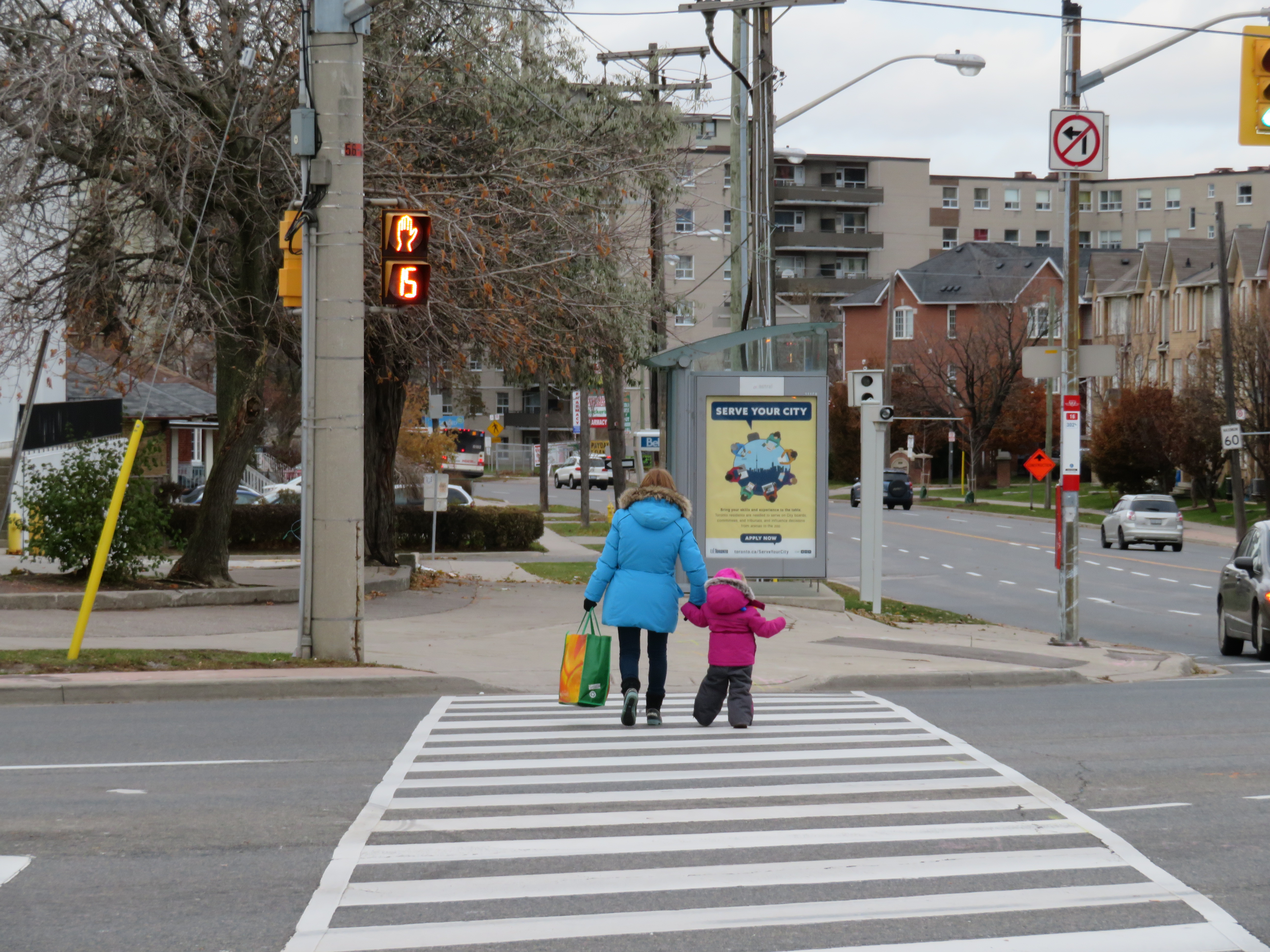 Woman and young child cross seven lanes of traffic at a crosswalk at Eglinton Avenue East and Danforth Road
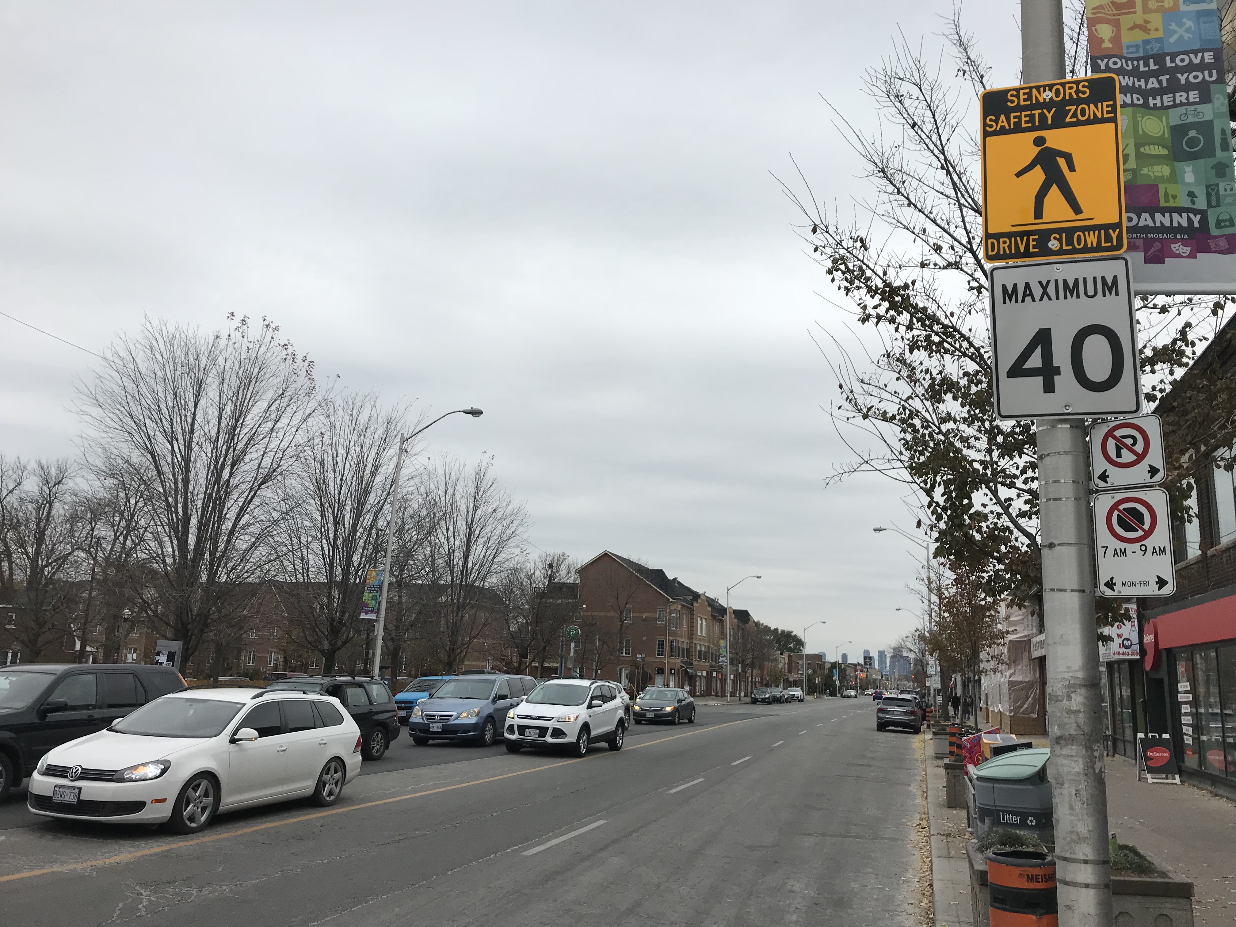
 Seniors Safety Zone sign on Eglinton Avenue East, at Brimley Road. Note the 60 km/h speed limit sign
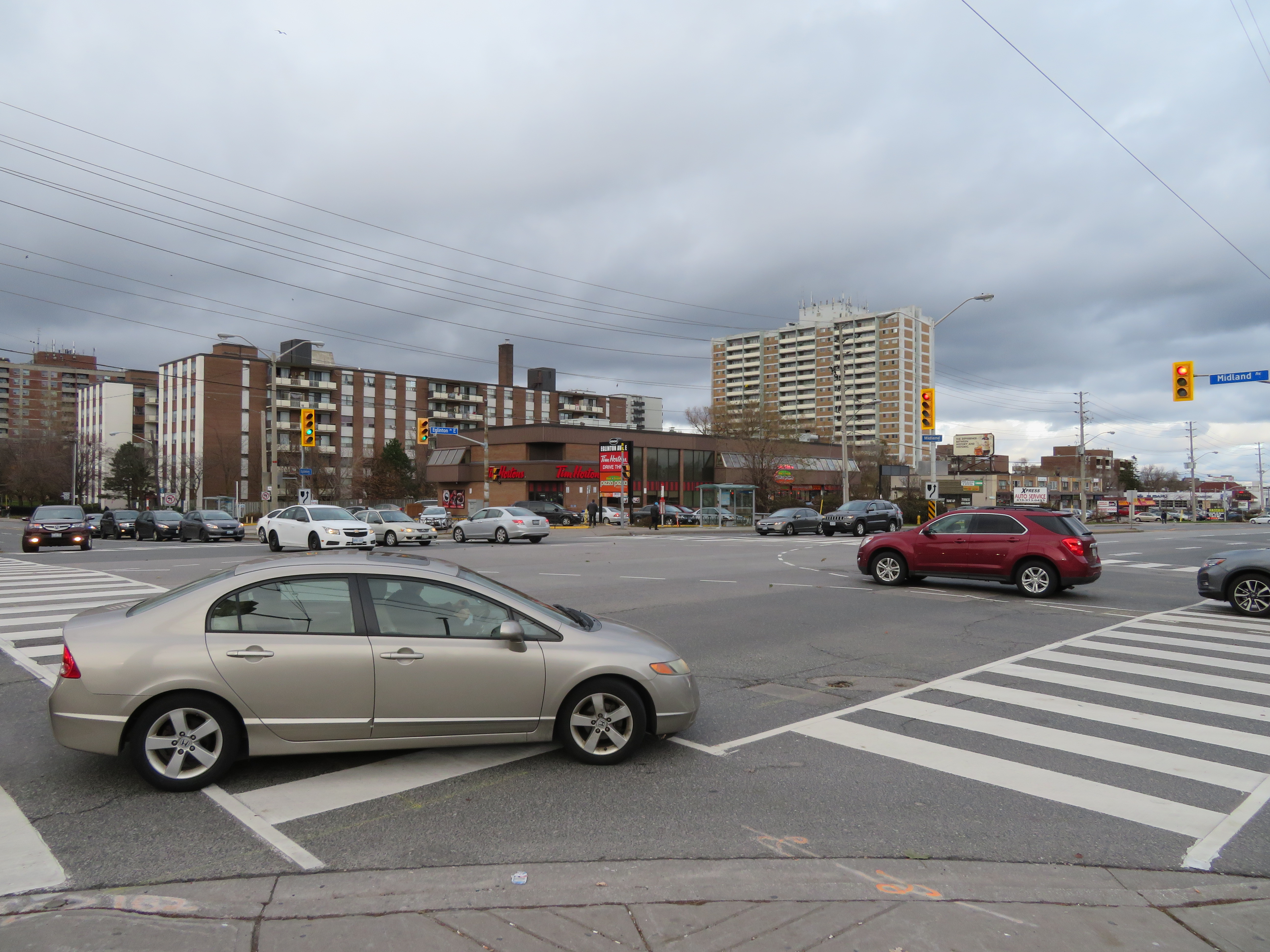 At Eglinton and Midland Avenues, wide curb radii encourage speedy right turns into crosswalks; many drivers do not stop at the red light before making a right turn