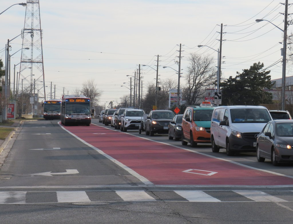
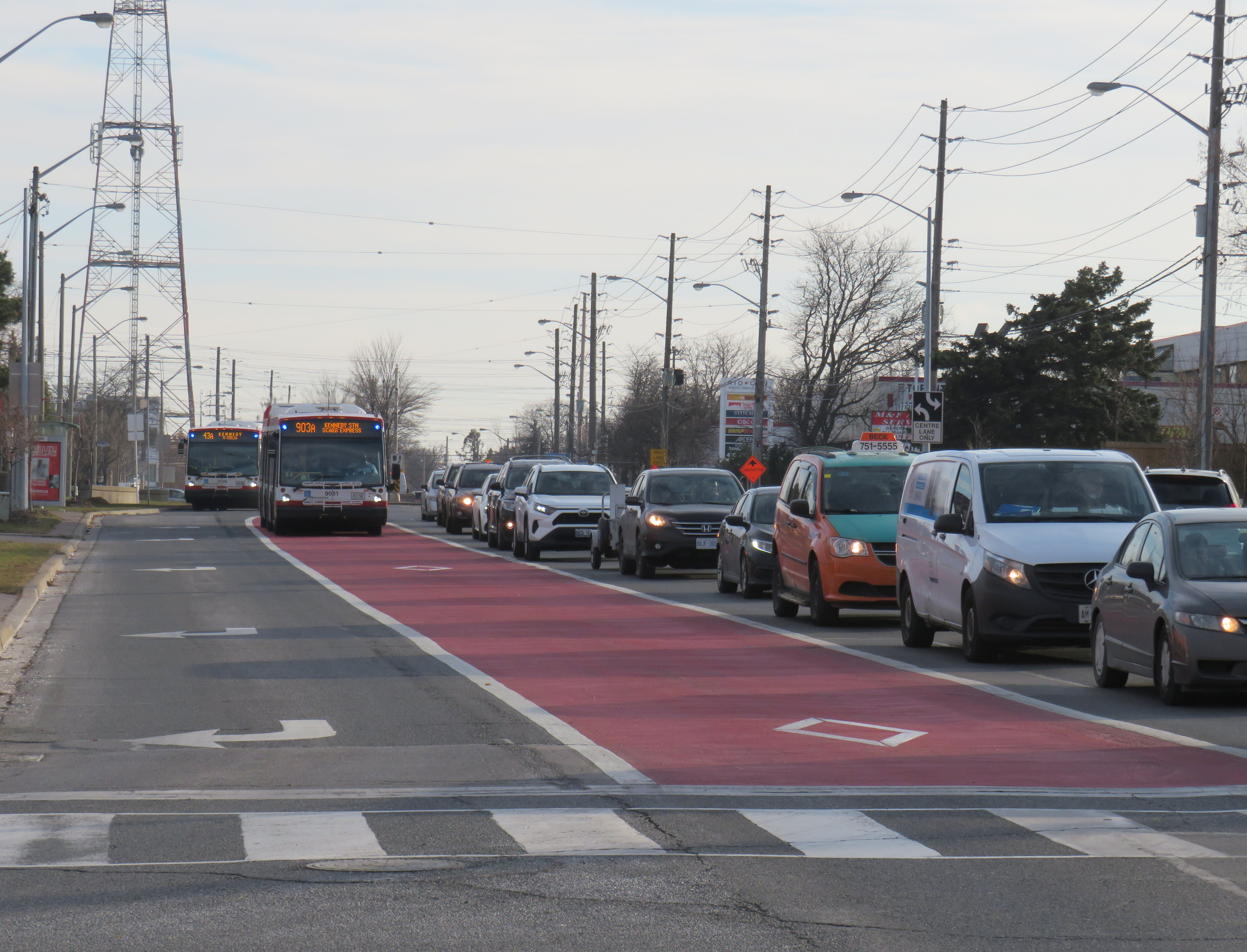
Adding priority bus lanes is one way to speed up transit across the entire city
Transit planning is a long-term endeavour, not a one-time project with a single solution. In a municipal election year, we need to demand more from leaders and those charged with planning and running transit services than simple soundbites that recall old political slogans.
In Spacing, I wrote about the trouble of resorting to catchphrases such as “subways, subways, subways” when our transit troubles are more widespread — yet also fixable. We simply cannot rely on a single solution to our transit woes.
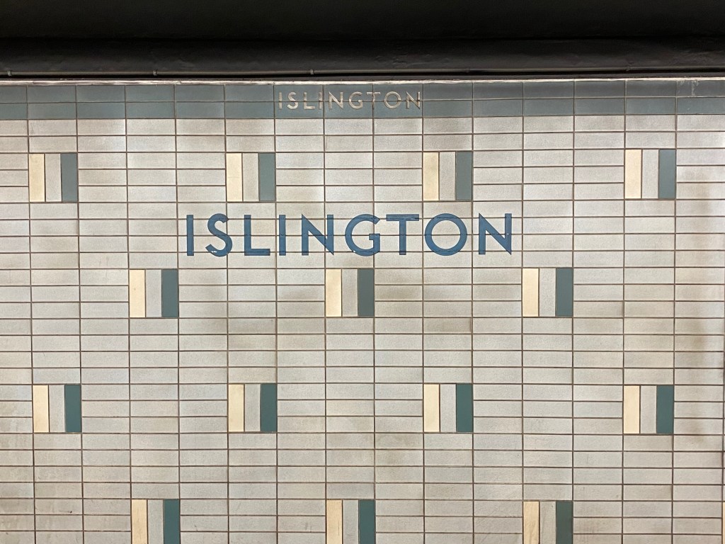
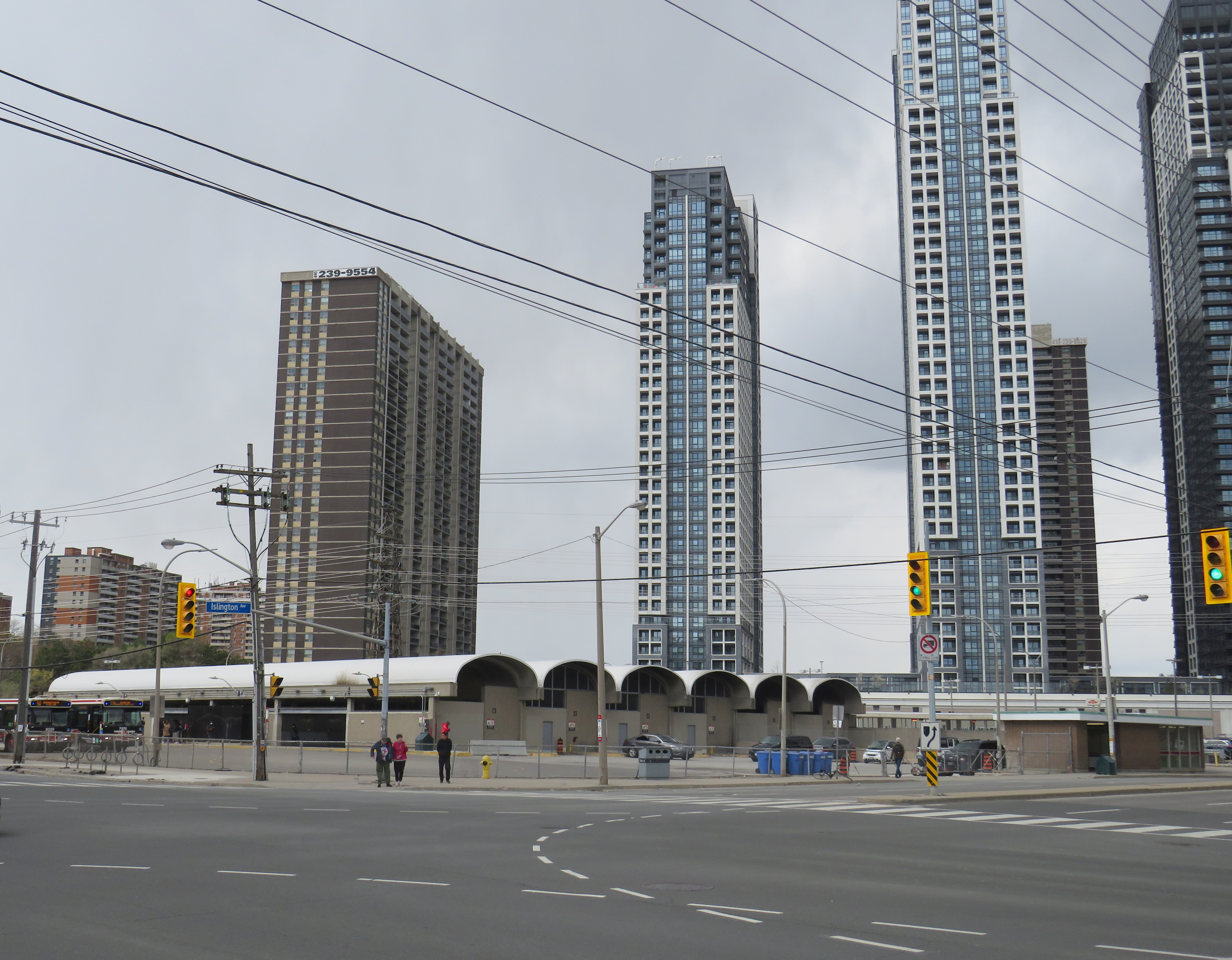
Islington Station, opened in 1968 as part of a major expansion of the Toronto subway system into Etobicoke and Scarborough, is now literally falling apart.
At platform level, Islington looks little different than most stations on the Bloor-Danforth Line with the faded wall tile, coated with a layer of brake dust. Upstairs, on the concourse level and the old bus terminal, the station is in far worse shape. Wear and tear from hundreds of buses entering and exiting the station every day, along with water seepage from an underground stream, has caused the station to look much older than it actually is.
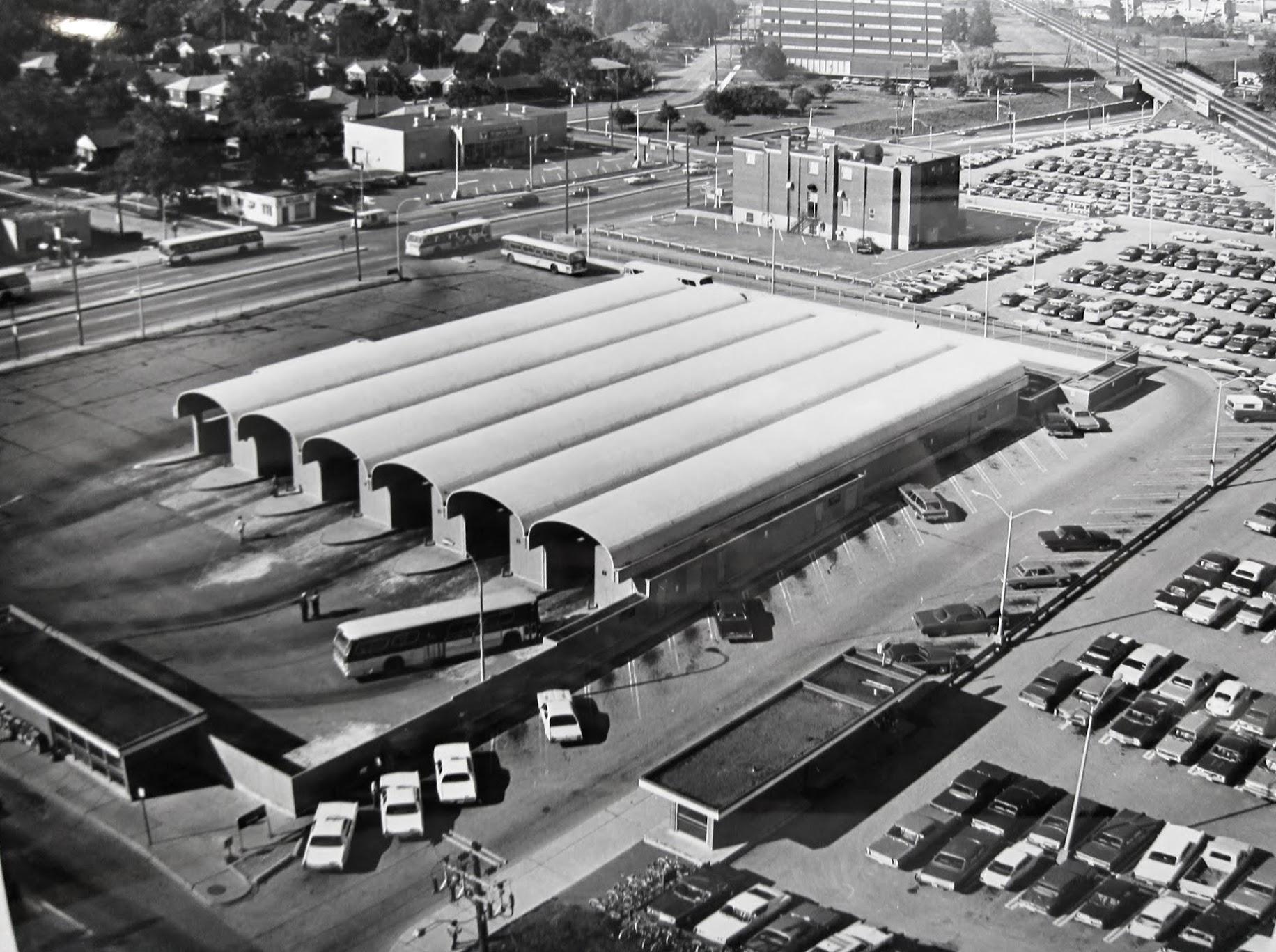
From 1968 to 1980, Islington Station was the Bloor-Danforth Line’s western terminus, with buses branching out to points all over Etobicoke. The bus terminal boasted six bus bays, each with its own driveway. One of the six platforms was dedicated for Gray Coach services, which included an express bus to Pearson Airport.
An arriving bus would first pull into the east side of the terminal, with all passengers descending a set of stairs to the subway concourse, either to transfer to the subway, exit the station, or transfer to another bus route. The bus, once the operator took their break, would then pull forward to the boarding area, where a second set of stairs emerged from a waiting area. Below, on the concourse level, a flashing light would alert waiting passengers that their bus was boarding. The terminal design was similar to the original bus terminal at Eglinton Station; at Warden Station, the levels are reversed, with the bus bays below the passenger concourse.
Aerial view of Islington Station’s bus terminal in 1975, City of Toronto Archives, Series 836, Subseries 4, File 46. Note the Mississauga Transit bus passing by on Bloor Street. Looking northwest toward the sealed-off bus terminal, May 2023
In 1980, the subway was extended one stop westward to Kipling. The extension allowed the TTC to reroute most of its Etobicoke routes from Islington, which provided new space for Mississauga Transit, whose buses now loaded inside the bus terminal. (As the bus bays are inside the station’s fare-paid area, Mississauga Transit buses off-loaded passengers outside the station’s main entrance on Islington Avenue.) A seventh bay, located to the south of the original structure, was added to provide additional capacity for Mississauga Transit, however, only simple bus shelters provided protection from the rain and snow.
But by 2016, the bus terminal area was starting to crumble, and bus bays 1 and 2 (the bus bays closest to the subway platforms) were closed permanently to prevent further structural damage. Mississauga and GO Transit planned for a new terminal adjacent to Kipling Station, but it was delayed by several years. Part of the delay was caused by Hydro One — owner of the transmission lines that parallel the subway and adjacent Canadian Pacific Railway corridor — who refused to allow a terminal building under its wires.
The opening of the new Kipling terminal for GO and Mississauga Transit buses in May 2021 (repositioned to avoid the hydro corridor) allowed the TTC to permanently close the crumbling bus terminal bays. All remaining buses — 37/937 Islington, 50 Burnhamthorpe, and 110 Islington South — began only using the outer bus loading area in late 2021.
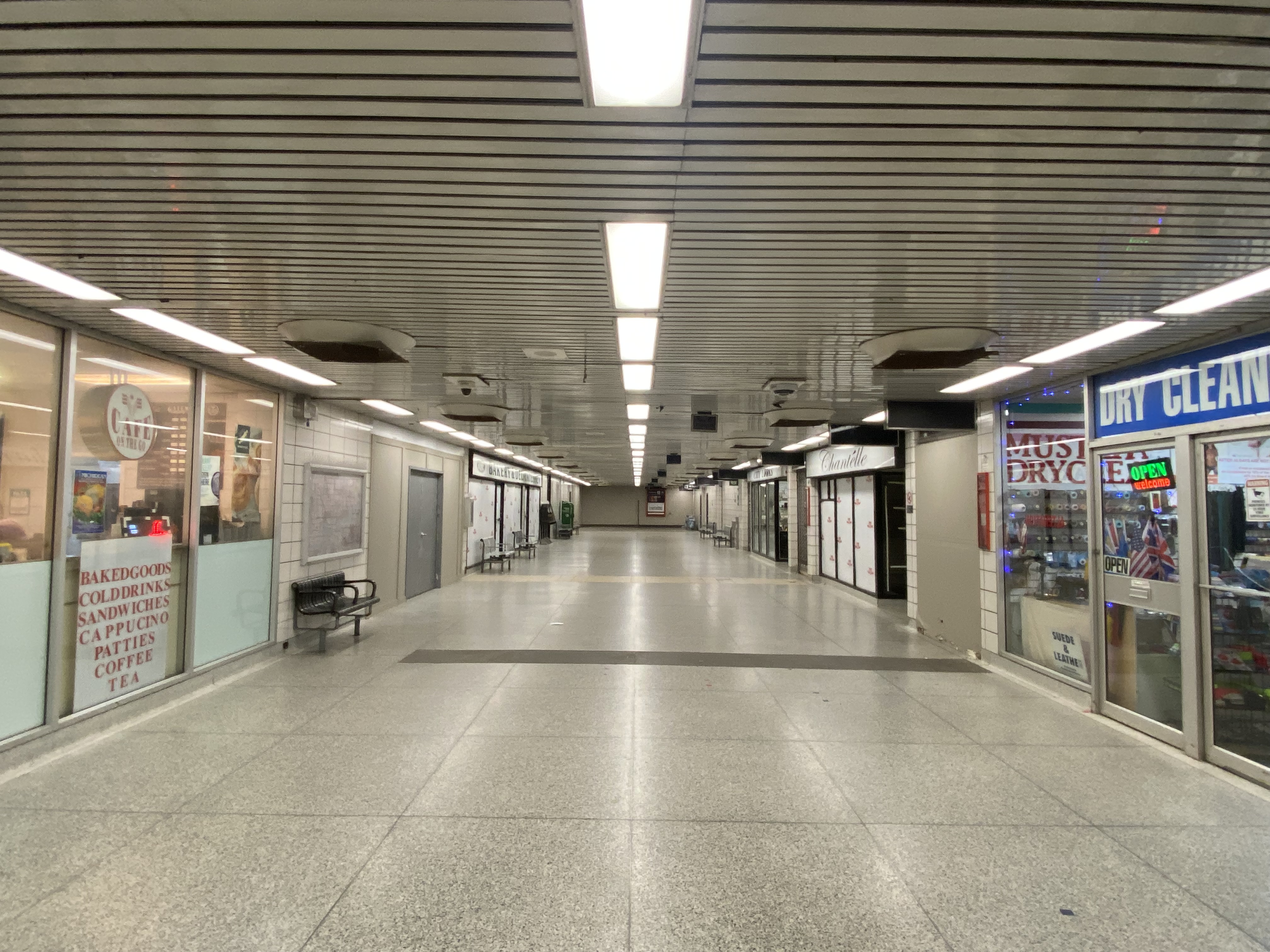
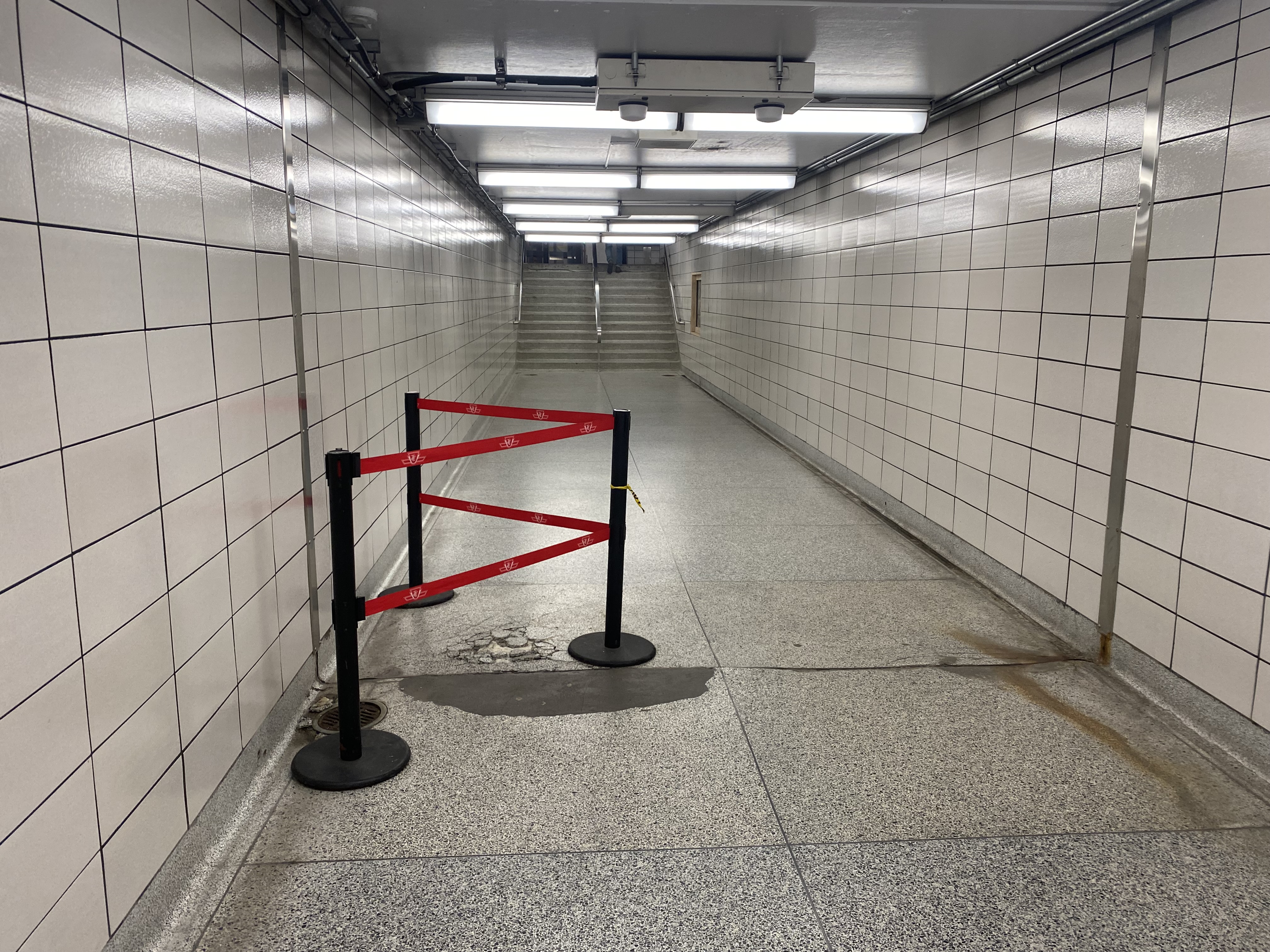
Bus passage, Islington Station. Stairways to the old bus bays are sealed off, with the signs above the old stairways blacked out. Passengers transferring to TTC buses must walk to the far end of this corridor and then up a stairway to access the outer bus bay.
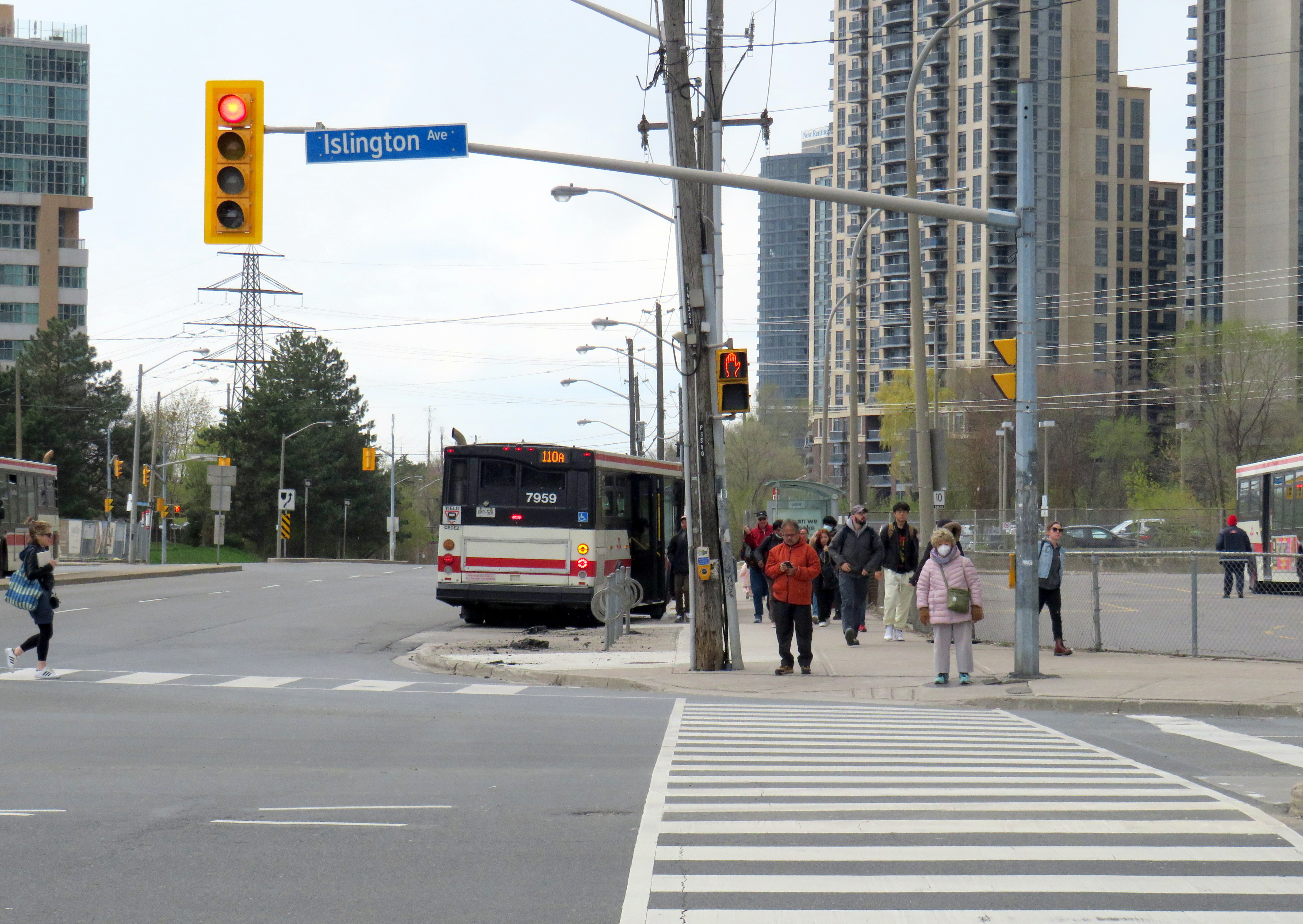
With little room remaining for buses to load, offload, and layover, passengers on TTC buses arriving at Islington are now let off on the street and must walk to the main entrance and show their transfer or tap their Presto card to enter the subway or transfer to another bus. Though Route 37/937 and 50 buses stop right in front of the station entrance on Islington Avenue, Route 110 buses off load on Bloor Street, a two-minute walk to the subway entrance.
A Route 110A Islington South bus off loads on Bloor Street; passengers must walk north to the subway entrance on Islington Avenue, to the right of this photograph
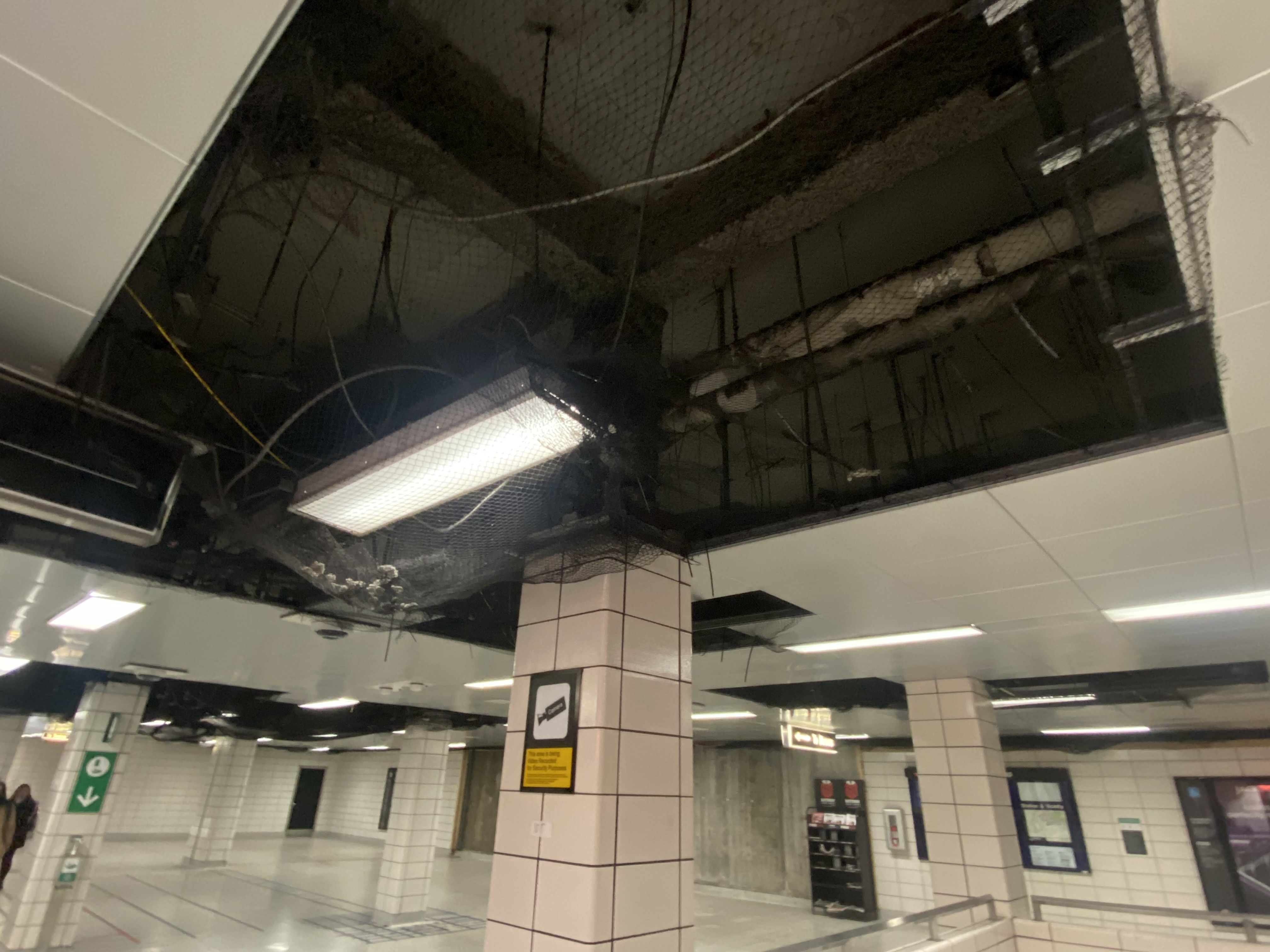
Since the bus terminal closure, the decay at Islington Station has extended beyond the bus area. On the mezzanine level, ceiling tiles were removed, while black netting catches chunks of broken concrete. Removed wall tiles reveal crumbling concrete and exposed rebar. Water leaks cover the mezzanine floor. There are no signs advising passengers of work underway or future construction, though there have been several plans to rebuild the station and promote new development on the site.
Fare gates partially obscured by temporary columns
Not only is reconstruction needed to rectify the deteriorating state of the station, Islington is also one of 15 subway stations that still do not have barrier-free access for passengers using wheelchairs or other mobility devices. Islington and Warden were left at the bottom of the list for station retrofits largely due to the difficulty of providing barrier-free access. The outdated bus terminal layouts at those stations require complete redesigns, and both stations are good candidates for urban development.
Netting keeps chunks of concrete from falling onto passengers’ headsCrumbling terrazzo floor in the passageway underneath Islington AvenueWater leak on the concourse level
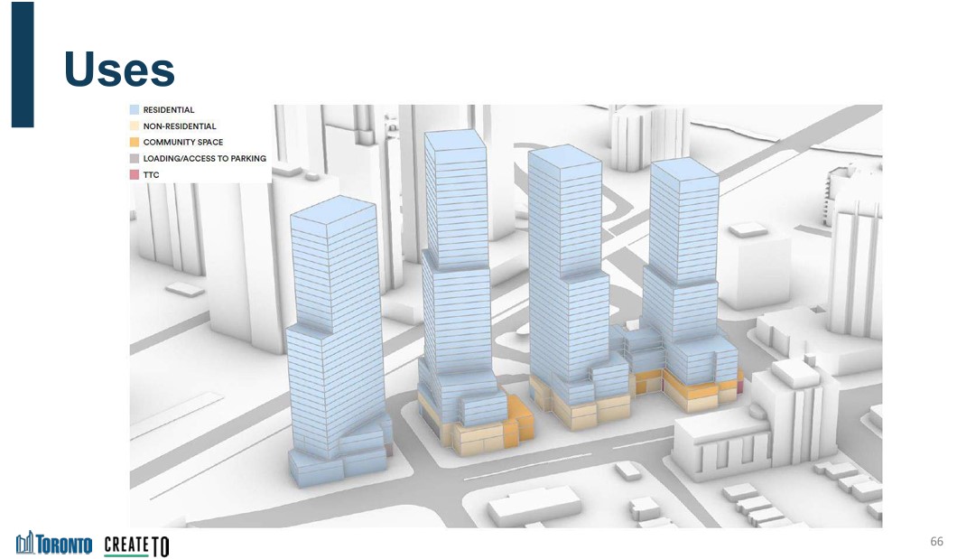
There have been several proposals for redevelopment at Islington, taking advantage of its large bus terminal area and parking lot. The city first looked at redevelopment in 2006. At that time, there was a proposal from engineering firm SNC-Lavalin for a new office building that would incorporate a rebuilt station. However, that proposal deal fell through.
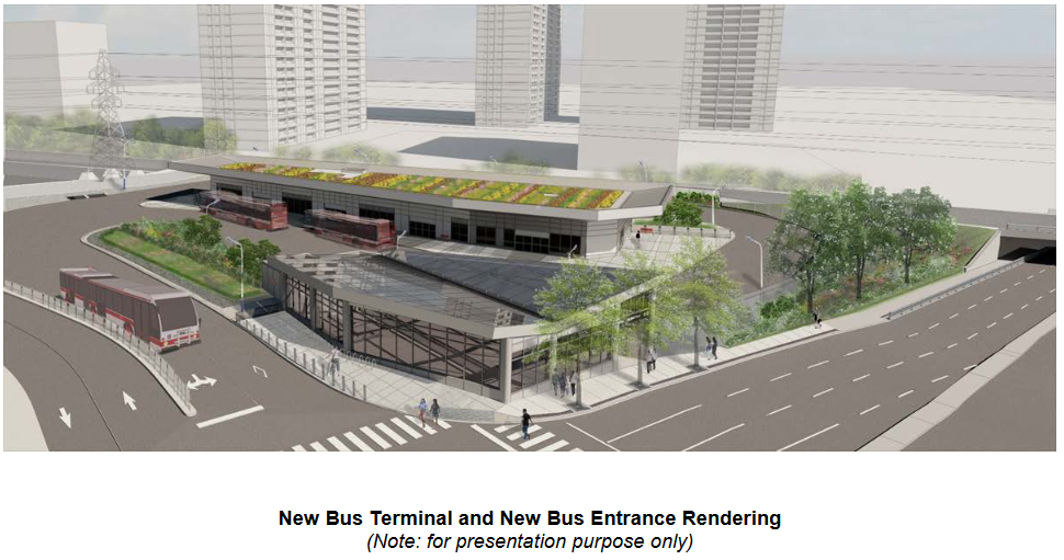
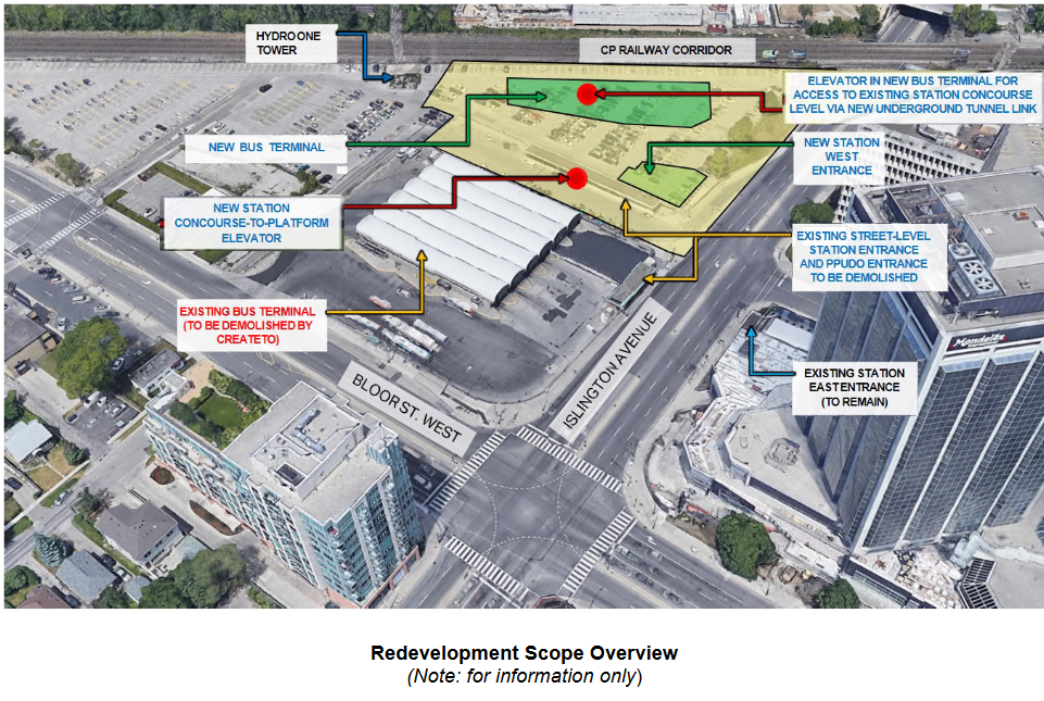
In 2021, a new plan to rebuild the station was presented to the public. It would include a new six-bay bus terminal in the commuter parking lot north of the existing terminal. Upon completion, the old bus area would be redeveloped under the city’s CreateTO housing program. Aberfoyle Crescent, which connects Islington Avenue and Bloor Street, would be extended through the station property to provide bus access and allow for development of the rest of the station property. The site is constrained by the same Hydro One corridor that stymied construction of the new Kipling terminal (much of the parking lot is under hydro wires), but this is a much smaller bus terminal, and hopefully lessons were learned this time.
Work on station construction was scheduled to begin in Spring 2023.
Rendering of new bus terminal and station entranceSchematic of the TTC station redevelopmentCreateTO development blocks at Bloor and Islington, from 2021 presentationCreate TO conceptual plan for Islington Station site
It is now mid-June 2023, and for now, there is no sign of work. Inside the station, there are no signs informing customers of impending construction, even if only to reassure passengers that the decrepit conditions are being addressed.
The many delays at Islington Station are also indictive of the difficulties of redeveloping even city-owned properties for new, much needed housing. It won’t be until 2026 — at the earliest — that new development can take place.
Until then, TTC customers must put up with a rapidly deteriorating station.
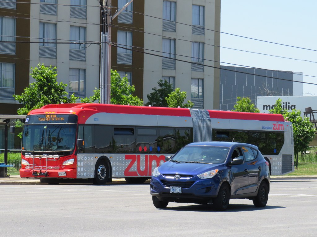
Brampton Transit bus on route 502 Zum with “bus full” displayed
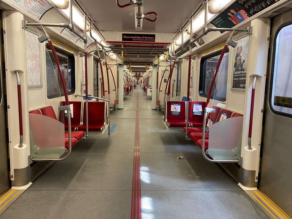
On Thursday, I took the subway for the first time since Ontario declared a state of emergency in March. I entered Queen Station at 9:45 that morning, and rode to Wilson Station. The subway ride north was noticeably quiet, and I had a good choice of seats, even though most were marked as restricted for physical distancing.
Empty subway train northbound on Line 1, June 11, 2020
On my return home, at 4:00 PM, the subway was busier, but still quiet enough to take a seat in the middle of the train, while just about everyone had a non-restricted seat through the downtown core. That never happened prior to March 13.
As I am used to crowded subway trains — even on Sunday mornings — my first subway rides in months proved to be a surreal experience. Though as most passengers were wearing face coverings and keeping distance, it felt safer and more comfortable than many of my recent supermarket trips.
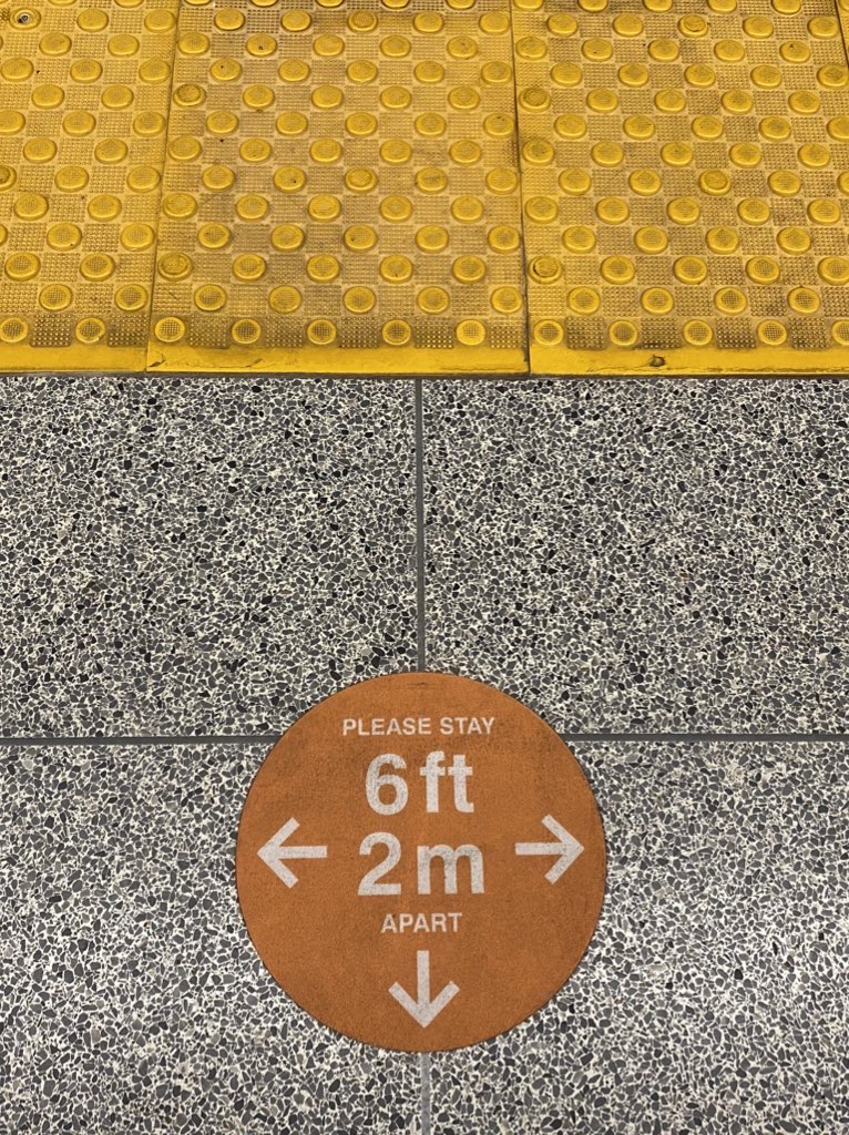
Platform edge marker, Queen Station
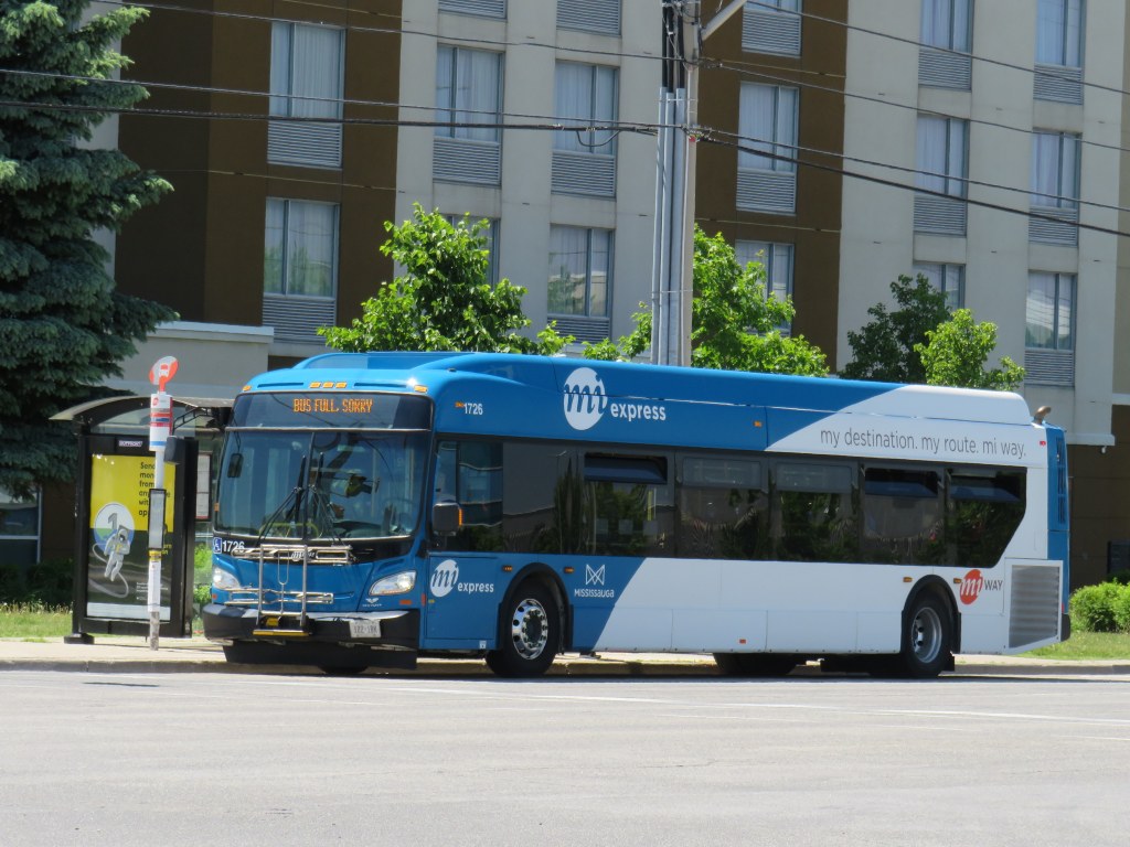
Though subways are mostly empty, and streetcars pass through downtown with only twenty percent of their normal ridership, things are very different on the buses. In Toronto, Brampton and Mississauga, vehicles regularly bypass crowds of waiting passengers while displaying a “sorry bus full” sign.
Miway bus full on Hurontario Street, on the same corridor as the Zum bus pictured above
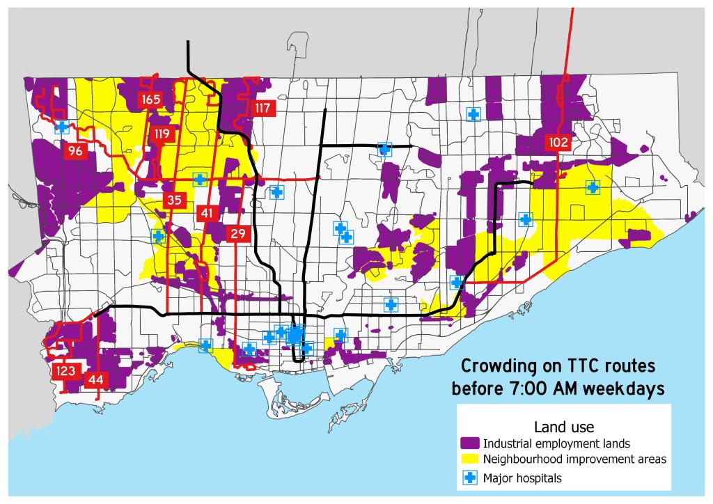
Back in March, I mapped the TTC’s most crowded early morning routes. These ten routes were generally located in Toronto’s suburbs, serving employment lands and neighbourhoods with lower incomes and higher proportions of racialized persons. Brampton and Mississauga, which also have large food production and warehousing industries and significant immigrant and racialized populations, are experiencing similar problems with crowding.
All buses only allow passengers to enter through the rear doors, with many seats marked restricted with paper signs similar to those on the subway. The area behind the driver is closed off as well. While the TTC expect riders to tap their Presto cards at the rear or pay by cash or ticket at a subway station, Brampton, Mississauga, and other systems are permitting free rides for now.
A typical TTC bus contains only 33-36 passenger seats; an articulated (“bendy”) bus has 46. The TTC operators’ union instructed its members to allow only 10 customers aboard a standard bus (though the operator has discretion), and 15 aboard an articulated bus. Transporting that few people on each bus is unsustainable, and with tens of thousands of essential workers relying on the TTC to get to work — many of those jobs difficult and poorly-paying — it’s yet another inequity laid bare by this pandemic.
Crowding on ten TTC bus routes in late March 2020
With loosening restrictions, the demand for transit has already begun to increase. By early July, local transit agencies will require all passengers to wear masks or face coverings. At the same time, passengers will be directed to enter buses through the front doors, while reinstating mandatory fare payment.
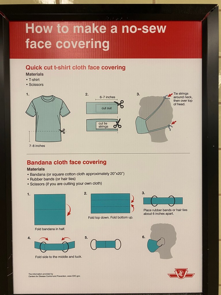
Poster in the TTC subway with instructions on how to make a no-sew fabric face covering.
Front-door boarding and mandatory mask use will help with some of the capacity issues on buses. Offering free masks is a welcome acknowledgement that many who have taken transit may not have money or time to purchase or make their own face coverings. (The TTC has instructions on how to make rudimentary masks posted in subway stations.)
Even then, bus capacity will continue to be limited to ensure physical distancing, and buses will likely still pass by crowds of waiting customers.
While central Toronto benefits from walkable neighbourhoods, existing and new cycling infrastructure, and subways and streetcars with more capacity to spare, suburban residents will still have to rely on buses. Though I see mandatory mask use as a necessary step towards mitigating the risk of viral transmission, I fear it may not be enough for those who work at hospitals and clinics, food plants and warehouses, and grocery stores, restaurants, nursing homes, and daycares.
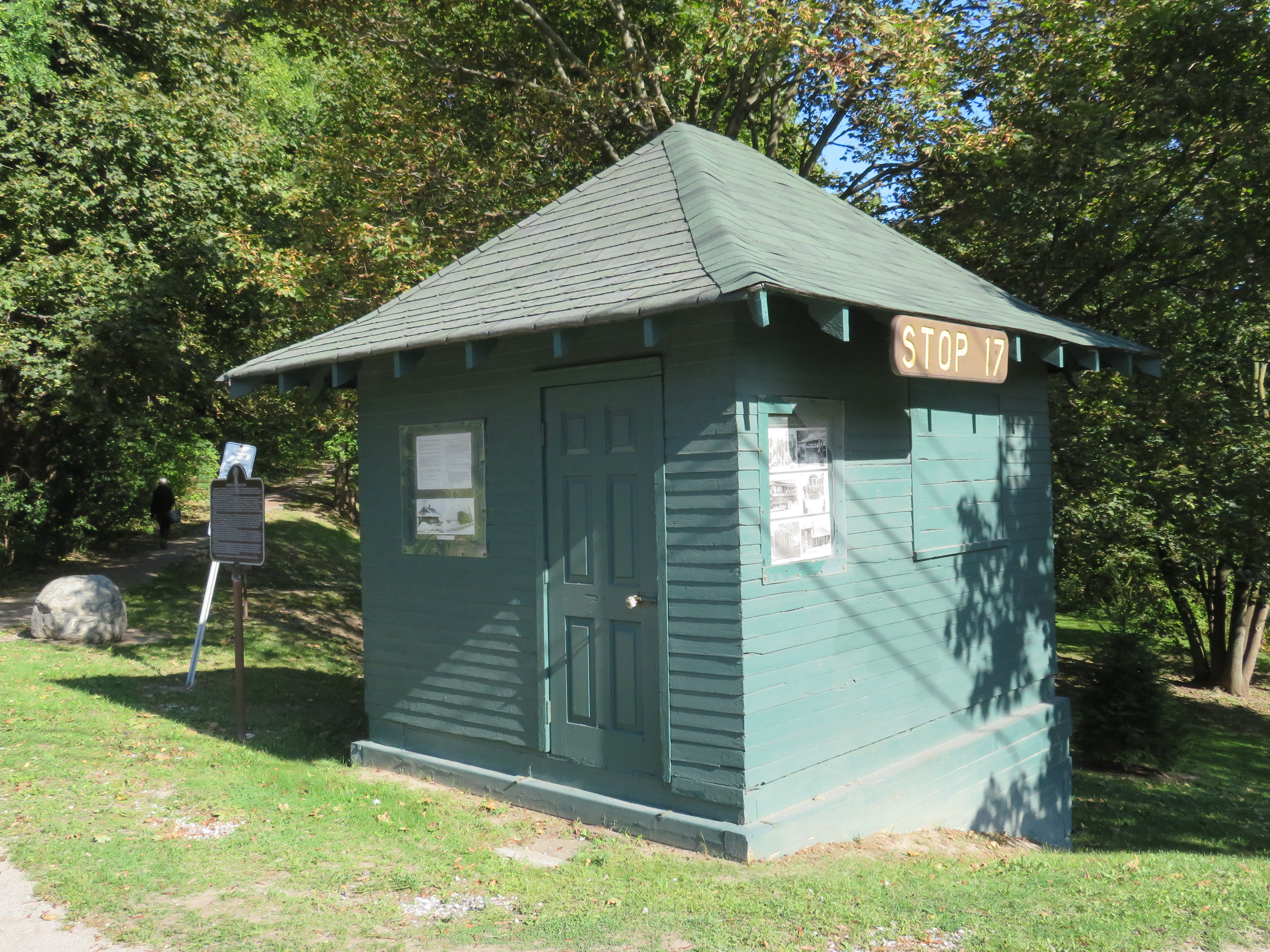
On Yonge Street in Thornhill, a small green hut sits beside the busy roadway at the entrance to Cricklewood Park. On the side of the small building, a wood sign says “Stop 17.” Hundreds of buses and thousands of cars pass by this hut daily, yet few may know about the transit history it represents.
Stop 17 was a stop on the Toronto & York Radial Railway line that extended north from a terminal at Toronto’s city limits at Yonge Street and Glen Echo Avenue (now the location of a Loblaws supermarket) all the way to Sutton, via Richmond Hill and Newmarket. Electric radial service to Thornhill and Richmond Hill began in 1897. By 1908, radial service reached Lake Simcoe.
Stop 17 was one of two stops in Thornhill, located at the present-day intersection of Yonge Street and Royal Orchard Boulevard. The TTC, the eventual owner of most of Toronto’s radial lines, closed the Lake Simcoe route in 1930. Soon afterwards, the wooden shelter was moved to a nearby golf club, where it served as a snack bar and rain shelter. (The radial line was resurrected in late 1930 as a suburban streetcar service to Richmond Hill until 1948.)
Yonge Street looking south in Thornhill, September 1931. City of Toronto Archives, Fonds 1568, Item 441.
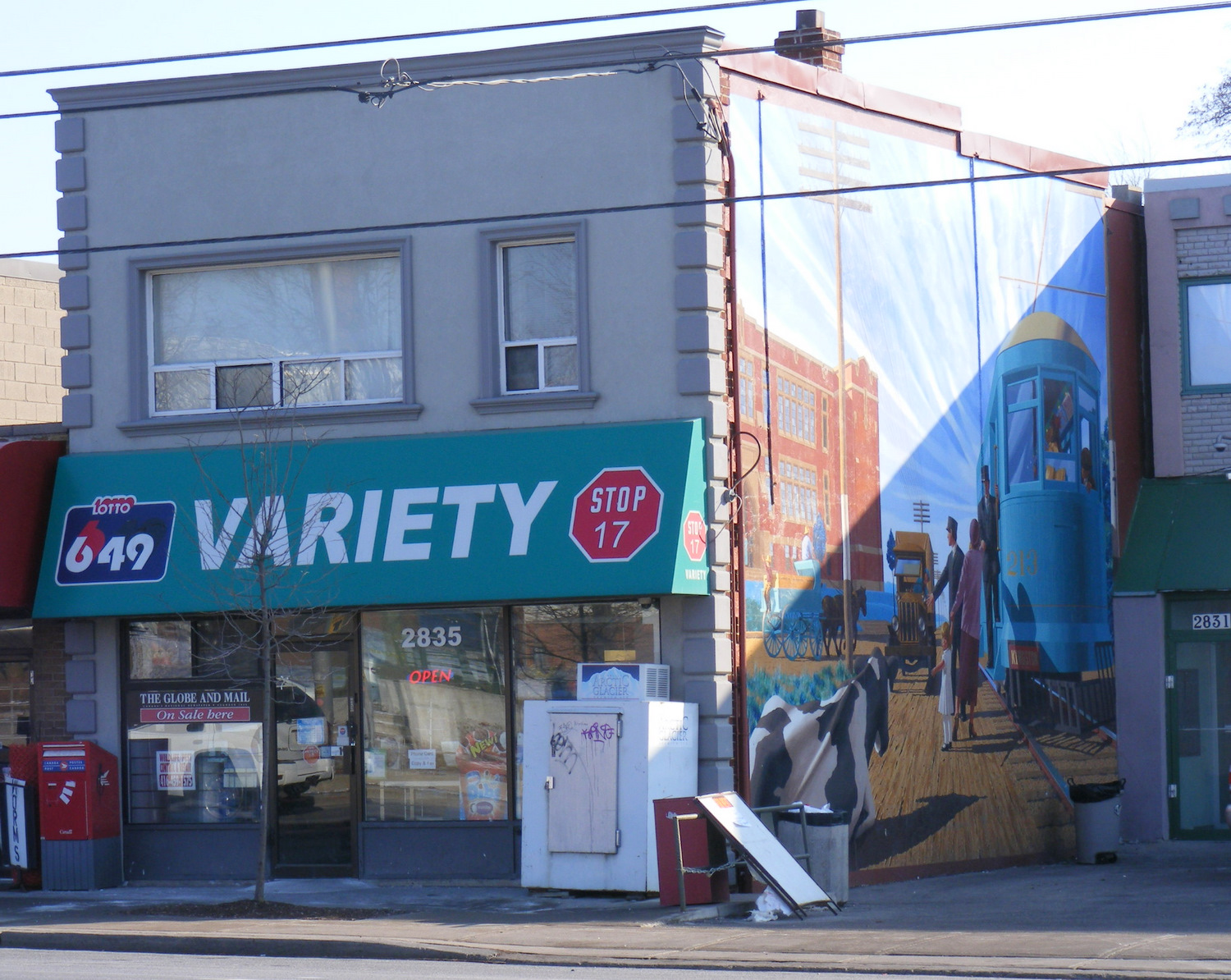
There was another Stop 17, on the Scarboro Radial Line between Toronto and West Hill. By coincidence, it is also memorialized in the name of a variety store (Stop 17 Variety), which also sports a mural depicting a T&Y radial car stopped in front of the Scarborough High School (now R.H. King Academy).
Stop 17 Variety on Kingston Road at St. Clair Avenue in Scarborough
Nearby the Stop 17 shelter in Thornhill, I noticed several markings in the sidewalk. After a closer look, I noticed that they were survey markers, indicating a location where holes were drilled for preliminary core samples for the planned Yonge North Subway Extension from Finch Station to Richmond Hill.
One day, the subway will be extended north into York Region, a sensible project given the ridership potential, especially as Yonge Street sees urban intensification through Thornhill and Richmond Hill. The City of Toronto has been resistant to the extension, as the Yonge Subway is already operating over capacity, with a relief subway required to handle the loads.
The politics of subway building aside, it is fascinating to find the history and future of Toronto’s suburban transit in such close proximity.
On the CBC radio program Metro Morning on March 28, Toronto Mayor John Tory spoke about his concerns regarding Premier Doug Ford’s plans to upload the city’s subway system, as well as Ford’s intentions to build new subway extensions to Richmond Hill and Scarborough Centre, bury the Eglinton West LRT, and start the long-planned Relief Line. Instead of a conventional subway, the Relief Line envisioned by the province would use a “new technology,” despite planning and engineering underway for a subway, using an existing subway yard for Relief Line train storage.
But Tory, who has been passive so far about the province’s plans, was hopeful that the unspecified new technology proposed for the Relief Line would be a “fantastic bonanza” for Toronto, but he added that he didn’t know for sure what would come of the new plan.
Mayor Tory tells @metromorning he's prepared to hold out hope that the province's unspecified new tech for the Relief Line is a "fantastic bonanza for us. But I don't know."
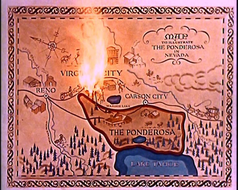
It is curious that Tory called this hostile takeover a “fantastic bonanza.” Bonanza was a long-running Western television show, starring Lorne Greene as the patriarch of the Cartwright family, owners of a vast ranch on Lake Tahoe. Bonanza was famous for its theme music and opening credits, which featured a burning map of the Cartwrights’ Ponderosa ranch before introducing the cast.
Opening theme for Bonanza
Bonanza’s burning map is a great metaphor for Toronto’s transit planning. Newly elected mayors and premiers burn the maps left behind by their predecessors, and time is wasted on new feasibility studies and engineering reports, ready just in time for someone else to get elected with yet another idea. Plans come and go, but hardly anything ever gets built.
There’s plenty of blame to go around. After a prolonged spurt of subway construction in the 1950s, 1960s and 1970s, momentum was lost. In the 1980s, Bill Davis’ Progressive Conservatives insisted on a novel linear-induction rail system for Scarborough, rather than the light rail project already underway. The Liberals, under David Peterson, proposed several subway lines, though it was scaled back under NDP Premier Bob Rae. In 1994, work started on the first phases of the Eglinton and Sheppard subways. When Mike Harris’ government was elected in 1995, they cancelled Eglinton, filling in a hole already dug for the tunnel boring machines.
There was new hope in 2003, when a new Liberal provincial government was elected, and David Miller, an urban progressive, became mayor of Toronto. While the province’s top priority was the extension of the Spadina Subway to York University and Vaughan, it was willing to help fund major improvements to GO Transit, along with new light rail systems in Ottawa, Kitchener-Waterloo, Hamilton, and Mississauga-Brampton. It also committed to Miller’s proposed Transit City LRT network, including a fully grade-separated replacement of the ageing Scarborough RT.
There were valid criticisms of Transit City — there were too many transfers to get around the top of the city, there was no Relief Line, and a few of the proposed lines, like parts of the Jane and Don Mills LRTs, were too difficult to build as surface rail projects. But because of Miller, the Eglinton-Crosstown LRT is well underway, and preliminary work continues on Finch Avenue West.
Work would have also started on the Scarborough RT replacement and expansion and the Sheppard East LRT, had Rob Ford not been elected in 2010, promising “subways, subways, subways” and burning the transit maps for which new projects were planned and being built. Seven funded LRT stops in Scarborough became three unfunded subway stops. Overestimating Rob Ford, and hoping to keep seats in Scarborough, the Liberal government folded to his demands, and work stopped on the LRT replacement.
Rob Ford’s disastrous term was followed by John Tory’s twin obsessions of SmartTrack and an austerity agenda, at a time when the Yonge and Bloor-Danforth subways were overwhelmed by demand caused by a growing population and a booming economy — hardly the conditions that demanded low spending on civic services and infrastructure and yet another half-baked transit plan.
SmartTrack map from the 2014 John Tory campaign
Tory promised that it would only take seven years to build SmartTrack, which would mostly use existing railway infrastructure, along with a new section of track in Etobicoke, on land already sold off for development. Tory’s insistence on SmartTrack further delayed momentum on the Relief Line. Though Tory remained committed to the Scarborough subway extension over the approved and funded LRT, it was reduced to a single stop as costs ballooned, while the subway and SmartTrack threatened to cannibalize each other. We don’t hear much about SmartTrack anymore, but at least Tory has come around on the Relief Line.
But Doug Ford’s latest musings make it clear why the planned subway upload is so dangerous.
Canada Line in Richmond, British Columbia
So what now for the Relief Line?
Despite the inevitable Simpsons monorail jokes (Doug Ford did promise a monorail on Toronto’s waterfront when he was a city councillor in 2011), the new technology the province is considering is likely an automated light metro line, similar to the Canada Line in Vancouver. The Canada Line links Vancouver’s city centre with the international airport and the suburb of Richmond. It was built as a private-public partnership (P3) project, in which a private company was contracted to design, build, and operate the line. It’s an attractive option for a conservative government: P3s promise to be cheaper to build and operate than a conventional public project.
But the Canada Line has problems. Though trains are frequent, it was built too small to accommodate growth. The outer terminals at Vancouver airport and Richmond-Brighouse are both single track/single platform. Station platforms are too short — only 40 metres long — to increase train sizes. And as many stations are underground, it’s too expensive to extending platforms to fit larger trains. Some relief is coming, but even then, the maximum capacity of the Canada line is 15,000 persons per direction per hour, far less than Vancouver’s SkyTrain lines or Toronto’s subway. If this is the route Toronto takes, it won’t be long before the Relief Line itself will need relief.
Once again, I fear that Toronto will continue to spin its wheels thanks to the Ford circus. And it’s a shame — though sadly not surprising — that Mayor Tory isn’t fighting back.
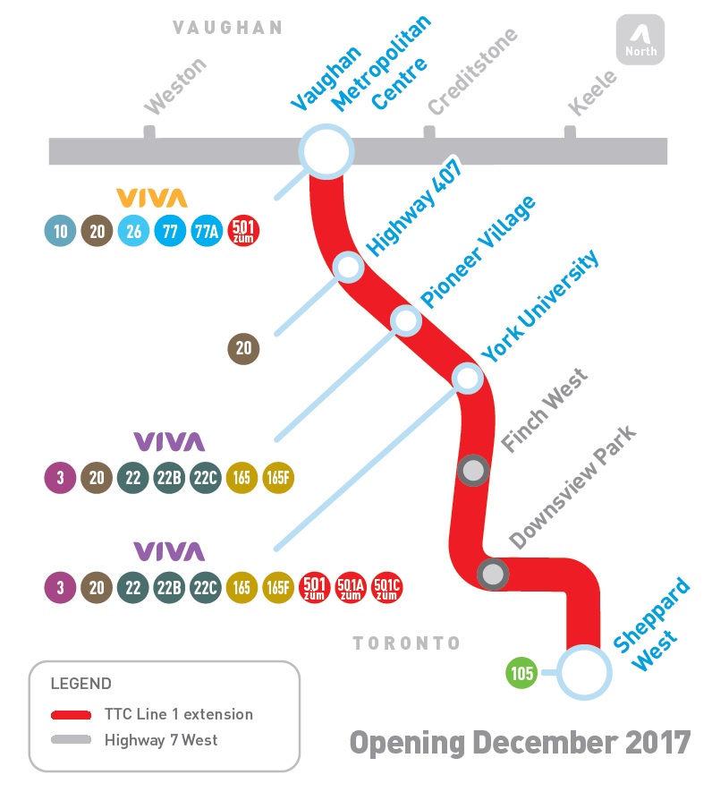
On Sunday, December 17, 2017, the TTC opened the long-awaited $3.2 billion Toronto-York Spadina Subway Extension to York University and the City of Vaughan. The extension of Line 1, which included six new stations, opened over two years behind schedule largely due to construction-related delays. It was the first subway to extend beyond Toronto’s boundaries; York Region is now pushing for another subway extension up Yonge Street to Richmond Hill.
Unfortunately, fare integration between the TTC and suburban transit agencies was never completely worked out, despite many years’ notice that this would be an issue once the subway extension was opened. A new GO Transit terminal was built at Highway 407 Station, meant to handle GO Transit’s many buses currently serving York University. York University and York Region Transit (YRT) signed an agreement that YRT would remove its buses from campus after the subway opened. There was an assumption that transit riders destined for York University would simply transfer to the subway, but measures to prevent those riders from paying a second fare were never worked out.
Many YRT passengers will have to pay the whole $3.00 each way, or be required to make a new transfer and/or walk a farther distance from the north terminal at Pioneer Village Station.
The fact that there’s no fare agreement to allow YRT passengers to ride the subway from Vaughan Centre to York University without paying a full TTC fare is indicative of the failure to fully coordinate regional transportation in the Greater Toronto and Hamilton Area. And York Region’s complete abandonment of what used to be one of its most important hubs is indicative of that region’s lack of commitment to funding transit operations adequately, despite its ambitious capital spending and lobbying for subway extensions.
Former Toronto Mayor Rob Ford liked to claim that subways would last one hundred years, while other “inferior” forms of transit, like light rail systems, would last only thirty.
At the time, Ford was pushing for a subway extension to Scarborough Town Centre that would replace the Scarborough RT. The SRT opened in 1985 and nearly thirty years later, the line needed a major rebuild, including new equipment. The City of Toronto planned to replace the aging system with a modern LRT route, including a three kilometre extension with two new stations at Centennial College and at Sheppard and Progress Avenues in Malvern. The line would have been fully funded by the province, and the rebuild would have reduced the cumbersome transfer from the subway platforms.
Of course, Rob Ford was wrong about subways lasting 100 years. While Toronto’s subway system is over sixty years old — the original Yonge Subway opened in 1954 between Union and Eglinton Stations — only the tunnels and station structures themselves remain from that era. The Yonge Subway is on its fourth generation of vehicles. Each of the stations have been renovated with new turnstiles, tiling, signage, and elevators. The TTC is also working on a new automated signalling system, and track replacement is an ongoing program.
Had the Scarborough RT been built as originally planned as an LRT route, there would only be the need for ongoing maintenance and new replacement vehicles. Extensions of the line would have been much easier and cheaper. The problem was that the planned route was converted — with pressure from the provincial government — to an Intermediate Capacity Transit System, a novel technology which was then being developed by the Province of Ontario. The rolling stock — nearing 30 years old — had to be replaced, and Bombardier, the successor to the provincial Urban Transportation Development Corporation, no longer built vehicles that could fit a tight turning radius between Ellesmere and Midland Stations. That’s why, after 30 years, the SRT needs a replacement.
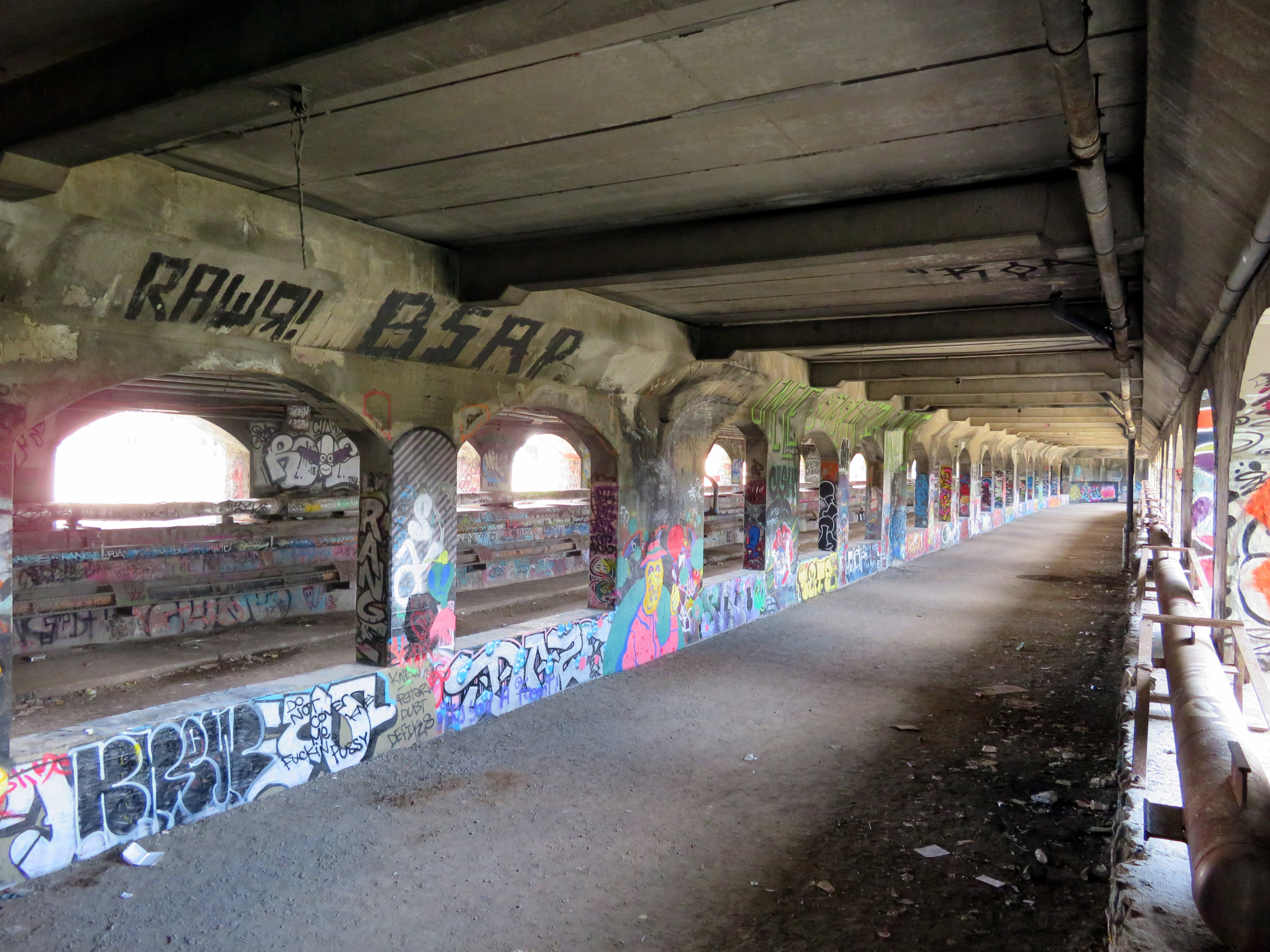
But you don’t have to travel far to see proof that subways don’t last a hundred years. In Rochester’s case, that city’s subway lasted only twenty-nine years before abandonment.
It also has America’s only fully-abandoned subway system.
The Rochester Subway was one of three subways planned and built in mid-sized American cities after the First World War. All three, coincidentally, were designed to permit streetcars to run under city streets using abandoned canal beds.
Cincinnati’s subway was the first to begin construction. Work began in 1919 on the path of the old Miami and Erie Canal, which once linked the Ohio River with Lake Erie at Toledo. But costs increased and construction was never completed. Today, the Cincinnati Streetcar runs on top of the abandoned subway route along Central Parkway.
Central Parkway in Cincinnati in January 2015, where new streetcar tracks run above the abandoned subway line
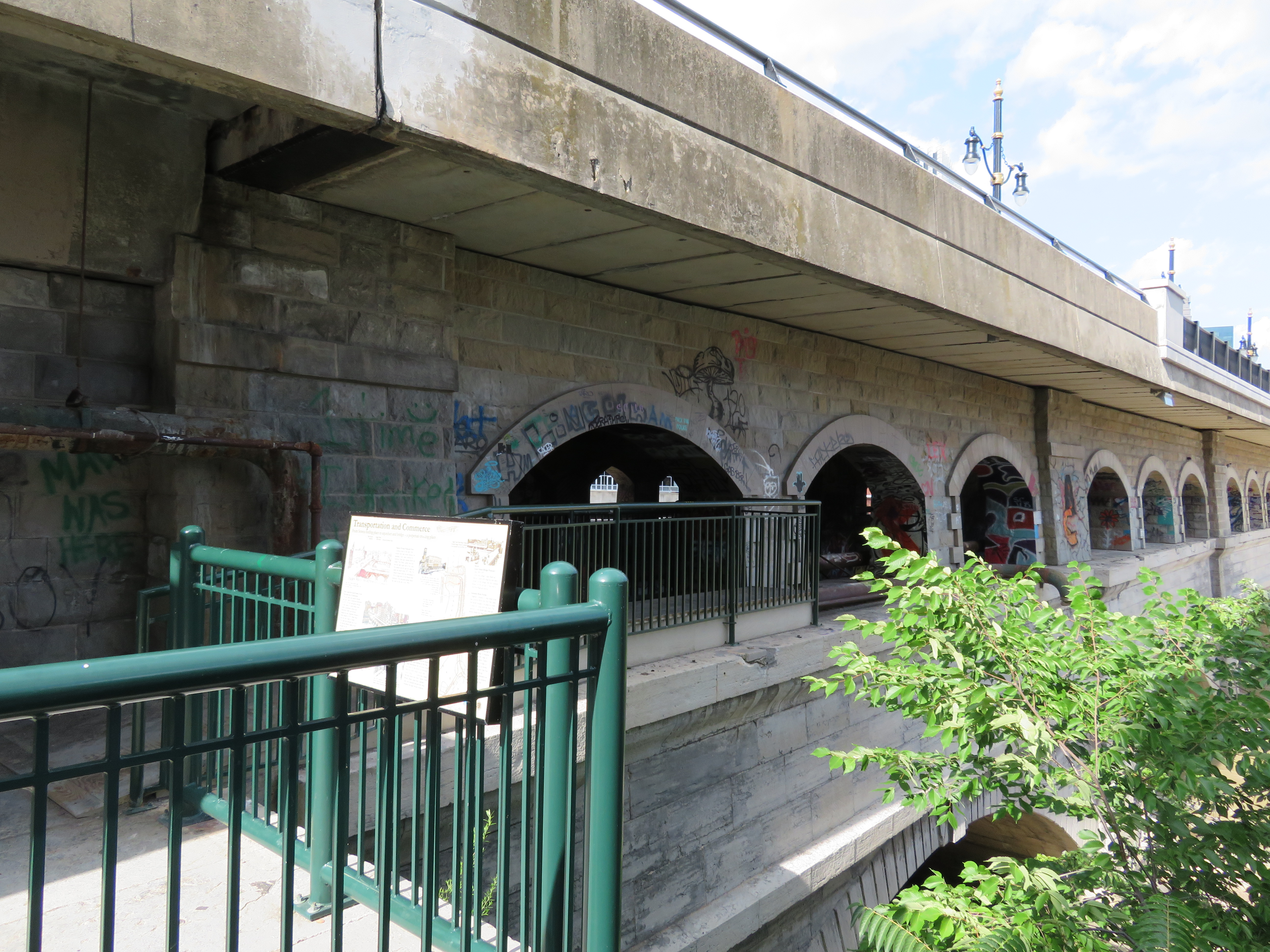
Rochester was the second city to build a subway line in a disused canal bed. The Erie Canal was rerouted around Downtown Rochester in 1919 and the new subway line — of which less than three kilometres was below grade — was built along the old waterway. A new downtown roadway, Broad Street. was built above the old canal. Service began in 1927 and was abandoned in 1956, as streetcar service in Rochester came to an end. Suburban growth along with population decline in old central city, and the prioritization of new interstate highways, put an end to rapid transit in that city.
Newark was the last city to build a new subway system in an old canal bed. Opened in 1935, the Newark City Subway was built between the Pennsylvania Railroad Station (which now serves Amtrak, NJ Transit commuter trains, and PATH subway trains to New York City) and northwestern suburbs. The City Subway, which operated PCC streetcars until 2001, later became the core of New Jersey Transit’s Newark Light Rail System.
In Rochester, several sections of the abandoned subway remain visible to the public, including both tunnel portals. Stairs leading down from the Broad Street Bridge, which spans the Genesee River and once carried the Erie Canal, allow the general public to get a glimpse of the tunnel (it is also accessible from the Genesee Riverway Trail next to Blue Cross Arena without stairs), and all the graffiti lining the walls.
A public walkway from the Genesee Riverway at the Broad Street Bridge allows visitors to get a glimpse of the abandoned Rochester Subway
The dream is finally a reality for thousands of York University students
On Sunday, December 17, six new TTC subway stations opened, and tens of thousands of excited people crowded the new extension to York University and Vaughan (the free TTC fares, courtesy of the provincial government, might also have had something to do with it). I also took the opportunity to explore the new subway stations, and get a second sense of their layout and their ridership potential.
While Pioneer Village Station remains my favourite architecturally, I have found myself liking the simplicity of Finch West Station.
As I have argued here before, I expect that Finch West and Pioneer Village Station will be well used – mostly due to the TTC surface route connections. York University Station will do well during the academic term, and Vaughan Metropolitan Centre has potential — but only if York Region commits to operating a decent transit system with convenient and frequent service to the new subway. I also suggested that the main GO Transit connections — Downsview Park and Highway 407 — will see very little usage. Both stations rely on GO Transit connections, and at the time, GO did not make their plans public.
We now know that GO Transit service to Downsview Park Station will begin December 30. The Barrie Line will see new midday and evening service, and all trains will call at the new stop. Existing rush hour trains will also continue to stop at York University Station. All GO Transit buses on Highway 407 that terminate on the York University campus will also continue to do so, instead of taking full use of the new bus terminal at Highway 407 Station. (Only GO bus routes 25F, 46, 47, 47F, 48, 48B and 48F, along with route 40, will call at the fancy new terminal, adding up to 10 minutes to existing travel times.)
I predict that GO Transit will abandon York University Station and direct all its bus services to Highway 407 Station after the end of the 2017-2018 academic year, and after the provincial election is over. It would not be the first time that GO Transit abandoned one of its railway stations, either. In 1969, train service at Lorne Park was abandoned, in favour of nearby Clarkson.
The province announced a $1.50 TTC fare discount for Presto card transfers to and from GO Transit and UP Express in October, to take effect January 7, 2018. But without further fare integration for transfers to and from York University, students and staff who currently arrive on campus directly might have to get used to paying an additional $3.00 a day. But at least Highway 407 Station will be useful.
In a previous post, I also explained that Pioneer Village Station was architecturally my favourite of the six new stations. That is still true. But in terms of functionality, my favourite is now Finch West.
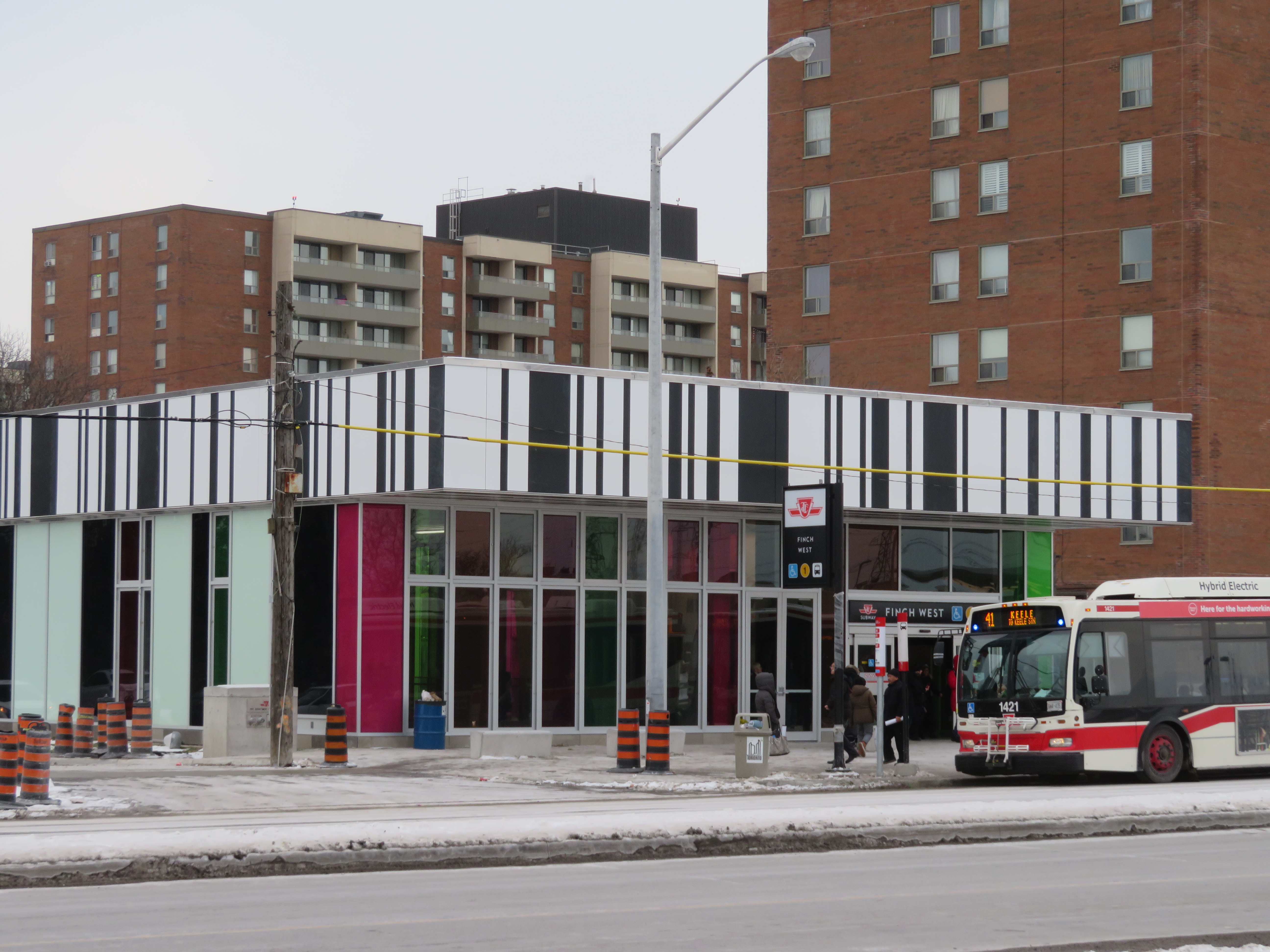
Southbound 41 Keele bus loads in front of the new Finch West Station. Note the nearby apartment buildings.
Finch West Station, like Pioneer Village, was designed by aLL Design, a global firm led by Will Alsop. The various tile patterns used in the design are a bit jarring, but to me, they recall those used in older TTC stations in North York.
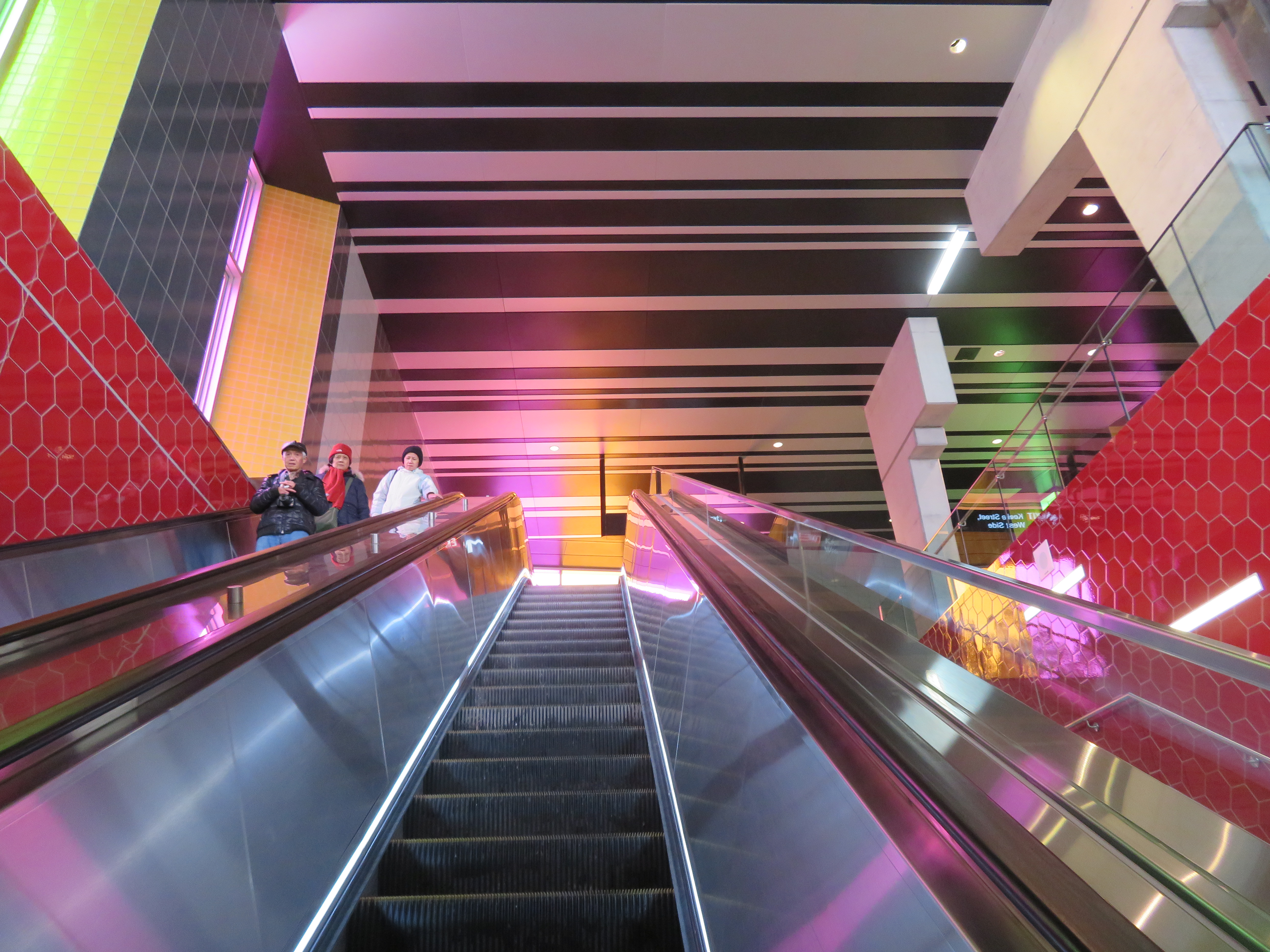
Ascending the escalator at Finch West
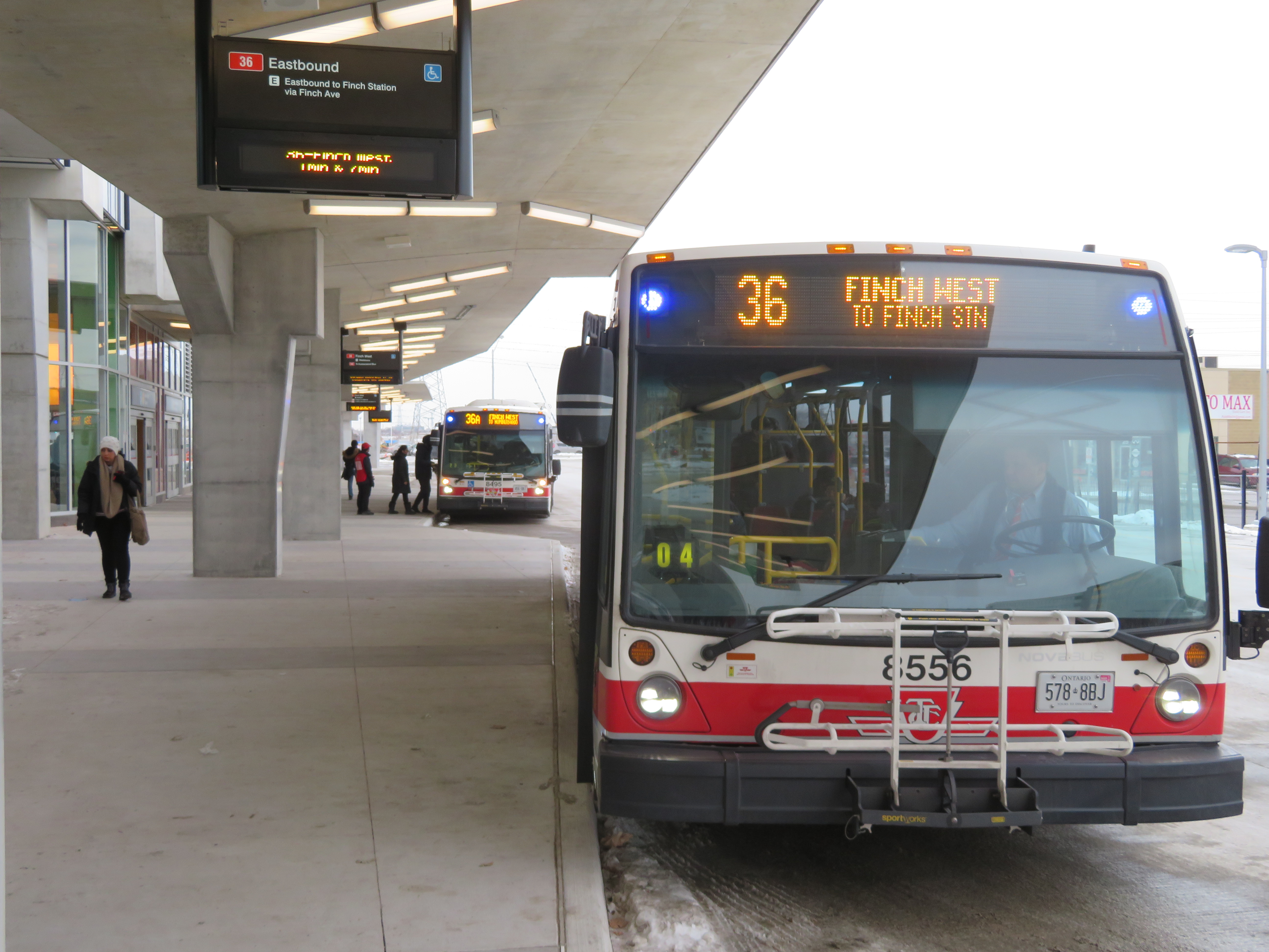
The station serves buses on routes 36 Finch West — the TTC’s third busiest surface route in 2016 — along with Route 41 Keele, 107 St. Regis, and 199B Finch Rocket. Only Routes 36 and 199B enter the 3-bay bus terminal, all others (along with the 36 bus) stop on the street. This simplicity is in contrast to the Highway 407 Station terminal, which will be little-used for quite some time.
Route 36 serves neighbourhoods such as Jane-Finch and Rexdale. These large, lower-income communities of Toronto will benefit from a much shorter ride to the subway.
Simple new TTC bus terminal at Finch West Station
In 2022, the Finch West LRT is scheduled to open, connecting Finch West Station with Humber College. On the mezzanine level, a temporary wall, as seen in the photo below, can be knocked out for a passage to a yet-to-be-built underground LRT station. Major construction is scheduled to begin in 2018.
Looking towards the temporary wall that will lead to the Finch West LRT
Finch West might not be the most stunning of all the new stations that opened on the Line 1 extension, but it might be the most useful and the most functional. In design, and in function, Finch West is a throwback, recalling a simpler time in TTC subway construction.
On Saturday, October 28, the Toronto Transit Commission (TTC) held open houses at three of the six new subway stations set to open on December 17, 2017 when the Line 1 subway is extended to York University and Vaughan. It was a fun afternoon with friends, checking out the architecture and the layout of Vaughan Metropolitan Centre,* Highway 407, and Pioneer Village Stations.
Some of the station architecture was stunning, and I came away feeling much less skeptical about Vaughan’s commitment to building a new urban district around its station. Most stations along the subway corridor will be well-used. However, I remain critical about the issue of transfers between transit agencies, and the usefulness of at least one station.
Ten months ago, I wrote about some of the unanswered questions about the Toronto Transit Commission’s Line 1 subway extension to York University and Vaughan. At the time, I was concerned about fare integration once the subway opened, especially if suburban GO, YRT, or Brampton Transit passengers headed to York University were required to make new transfers to the subway at Vaughan Centre or Highway 407 Stations.
We now know the day the six new subway stations will open: Sunday, December 17, 2017. We also know how the TTC, York Region Transit, and Brampton Transit will serve the new extension and York University. And today, we also have some indication of how GO Transit passengers will be affected by the changes.
How YRT and Brampton Transit will serve the Line 1 subway extension
(from the YRT website)
Transfers from GO Transit or UPX to the TTC will cost $1.50 for passengers using Presto cards, a 50% reduction from the full adult fare of $3.00. Passengers transferring from the TTC to GO or UPX will get a $1.50 fare discount. It is expected that the new co-fare subsidies will cost the provincial government $18 million a year. The fare discount will not apply to passengers using fare media other than Presto cards, including TTC tokens, Metropasses, or paper one-way tickets or day passes.
These are similar to the co-fares offered between GO Transit and transit agencies outside the City of Toronto, including MiWay, York Region Transit, Brampton Transit, and Hamilton Street Railway. However, these co-fares are generally more generous — ranging from $0.60 in Hamilton to $1.00 in York Region.
There was no news on reducing the fare penalty for transferring between the TTC and connecting local bus systems such as York Region Transit and MiWay.
For many commuters, the new TTC co-fare is great news, and it represents a good first step towards proper fare integration. It helps to make GO Transit more useful for trips within the City of Toronto, and it helps suburban commuters who use the TTC for part of their trip, such as University of Toronto students, who are located too far a walk to Union Station.
(John Tory is also claiming a victory, calling it “a step in the right direction” for his SmartTrack proposal. At this point, “SmartTrack” is little more than a GO/TTC fare agreement and a few new proposed GO stations.)
However, this could also affect York University students as well. Previous plans for the Line 1 subway extension saw GO Transit buses serve the Highway 407 station, requiring a transfer to the subway to get to campus. York University has been long eager to remove the buses from the York Commons area, which GO and the TTC use as their campus terminals.
York Region Transit will continue to operate many bus routes into York’s campus, on the Ian Macdonald Boulevard ring road, and Brampton Transit’s Queen Züm bus route will remain on campus. Their university-bound passengers won’t be required to transfer to the subway and pay an additional fare. But it appears, for now, that GO Transit passengers will have to make a connection, costing $1.50 each way. (This will not be the case for in the short term, see update below.) This will also apply to GO train customers on the Barrie Line who currently use York University Station, if that station closes as planned when the subway connection at Downsview Park opens.
This will be a blow for GO Transit customers who commute to and from York University, accustomed to a one-seat ride direct to campus. But it will be an improvement for GO operations on the Highway 407 corridor, with buses no longer stuck in traffic in the Keele Street and Steeles Avenue area. It will also benefit GO Transit passengers who aren’t headed to York University. Providing good public transit is not be about giving everyone a one-seat ride.
Despite these benefits, if GO Transit serves Highway 407 Station as planned, it will impact many passengers with a new transfer and an additional $3.00 cost per day. I’m curious what GO Transit’s messaging and final plans will be, because they have yet to communicate their new schedules and connections when the subway extension opens. Hopefully, we will learn the answers to the rest of those questions soon.
Update: According to the CBC and Metrolinx’s Anne Marie Aikins, there are now no immediate plans to re-route GO Transit buses from York University. at least in the short term. This is a short-term solution, however, because the Highway 407 station was designed with a large terminal for GO Transit buses, and York University has been vocal about wanting the hundreds of GO and TTC buses a day out of the York Commons area.
I don’t see this as a long-term solution, however. Hopefully Metrolinx and the TTC can figure out how to best serve York University passengers, though that should have been figured out a long time ago. After all, the subway was originally supposed to open by the end of 2015.


 Stop 17 Variety on Kingston Road at St. Clair Avenue in Scarborough
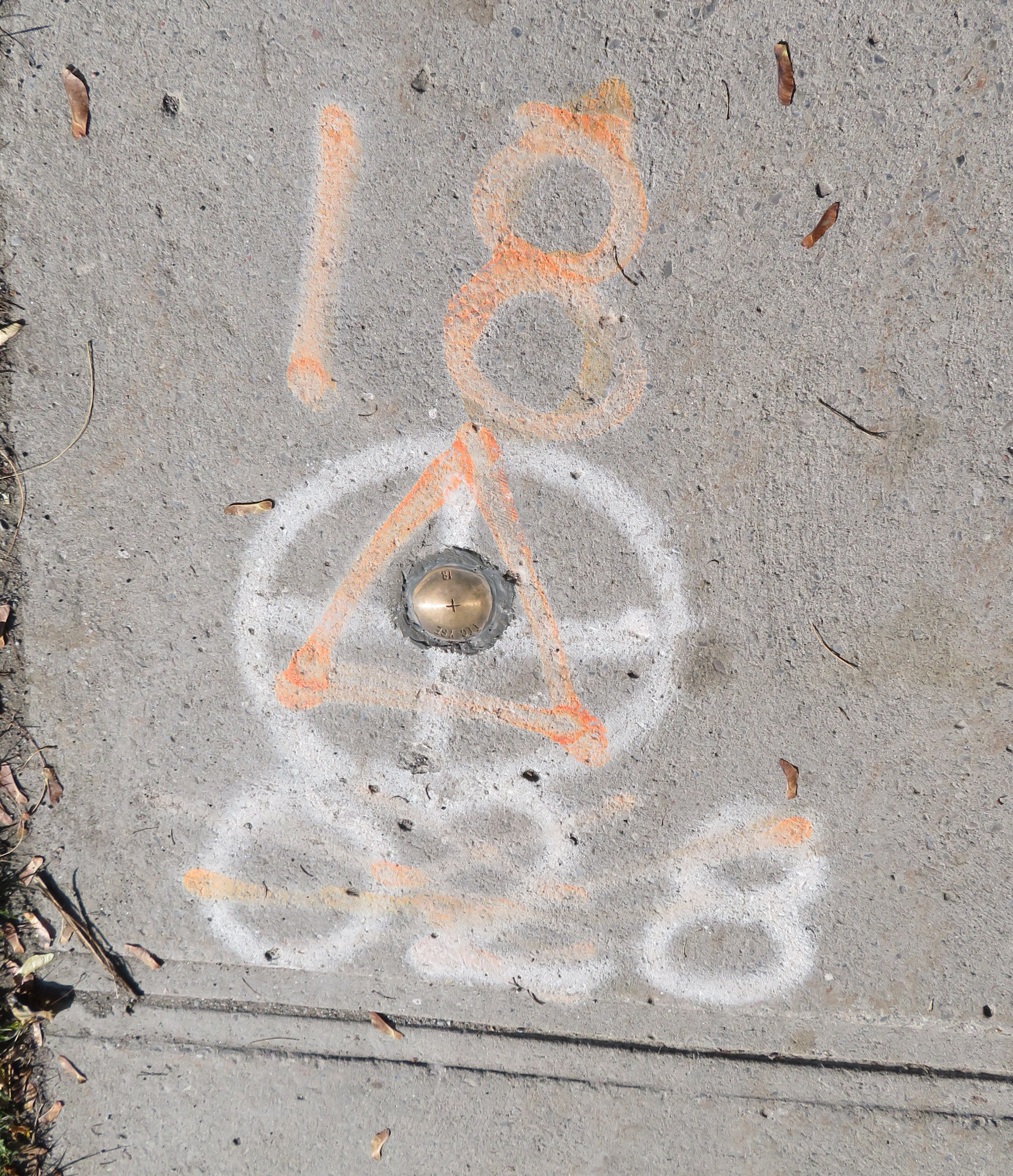

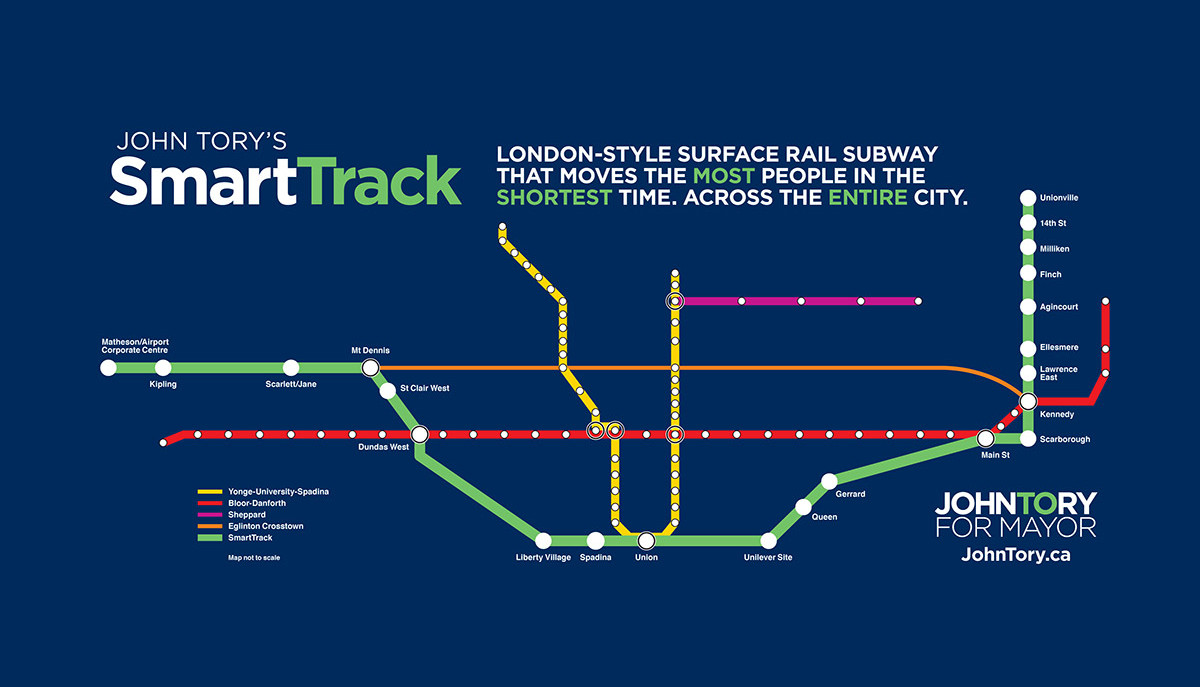 SmartTrack map from the 2014 John Tory campaign
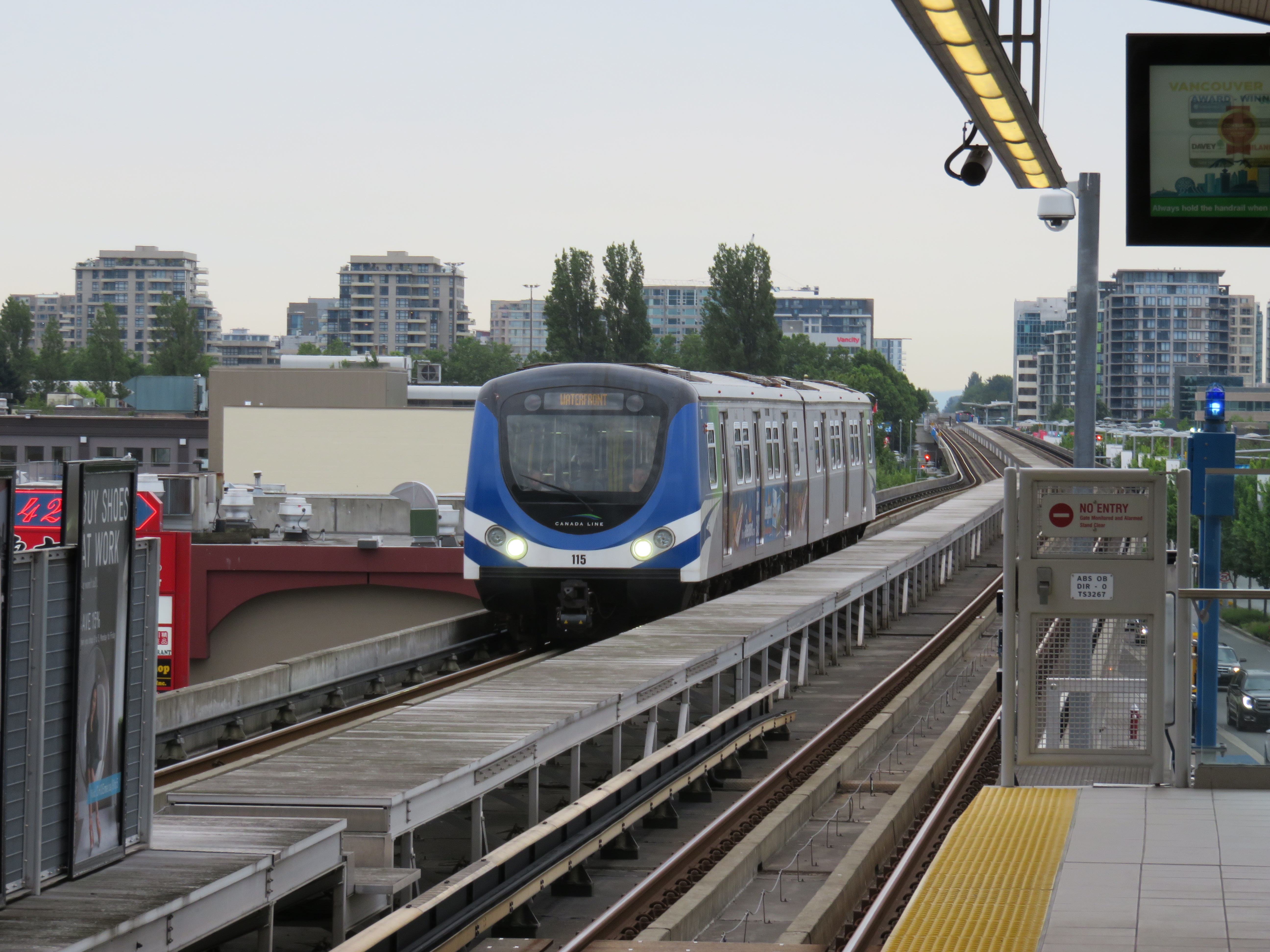 Canada Line in Richmond, British Columbia
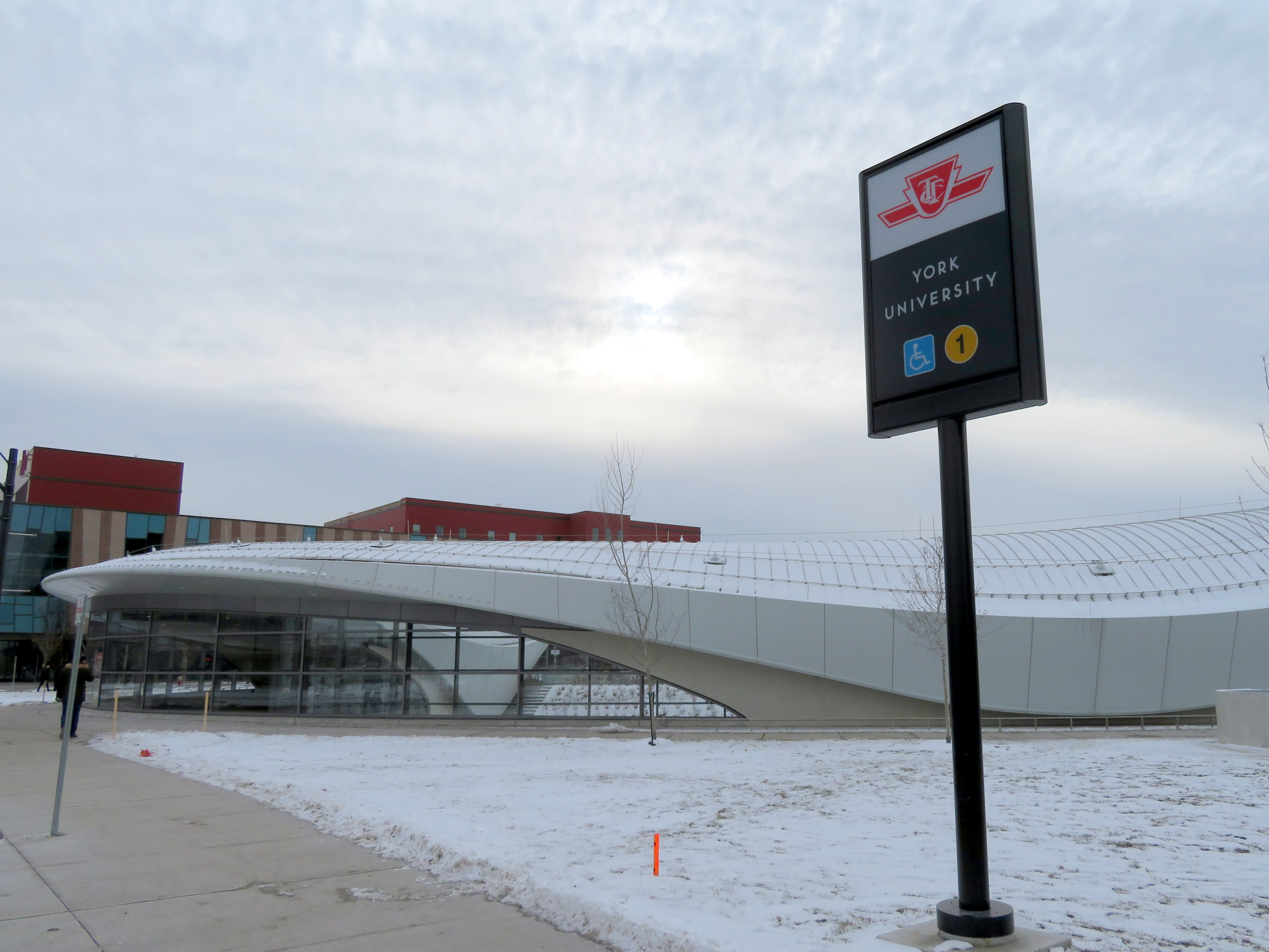
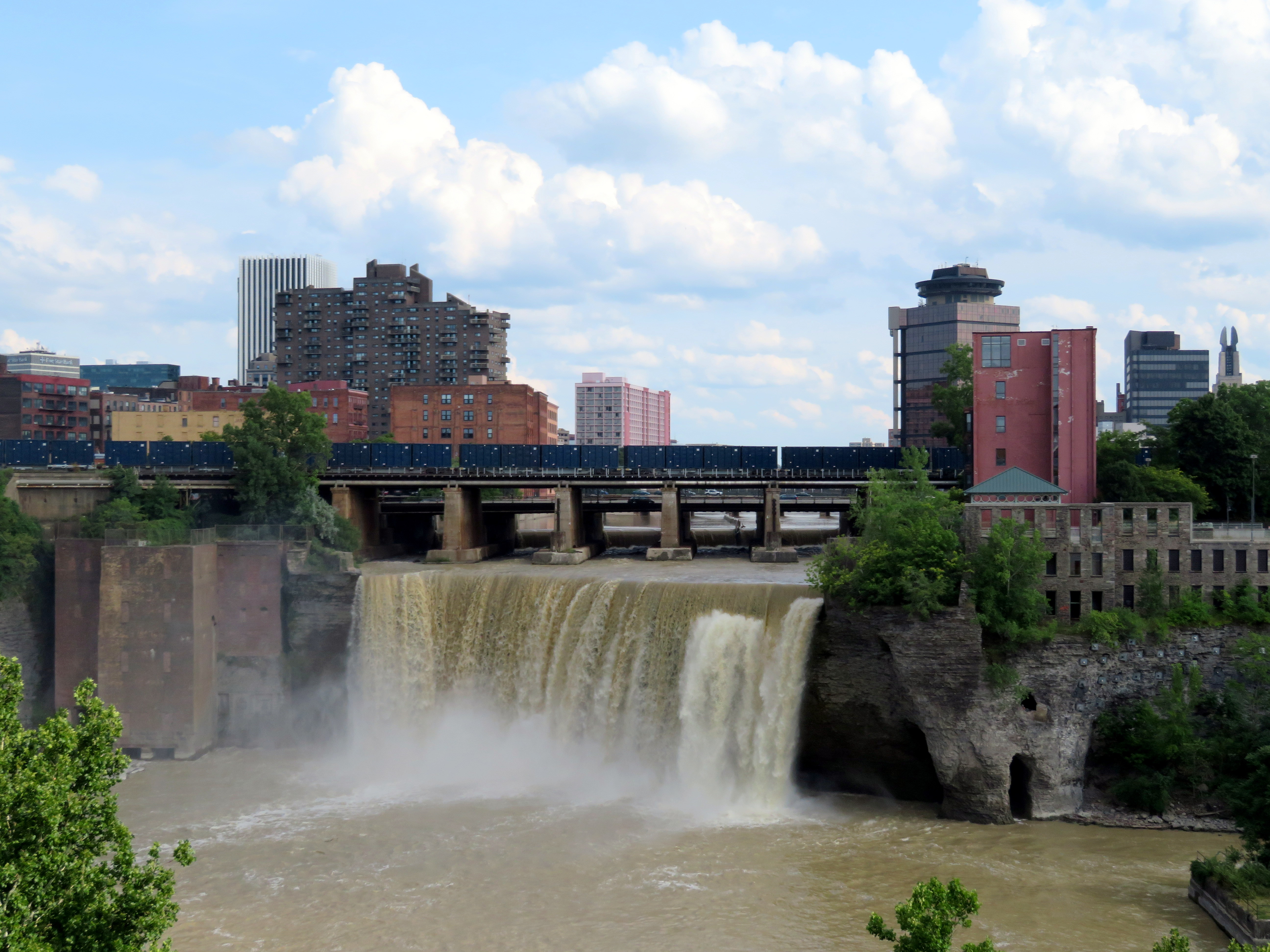 High Falls, Rochester
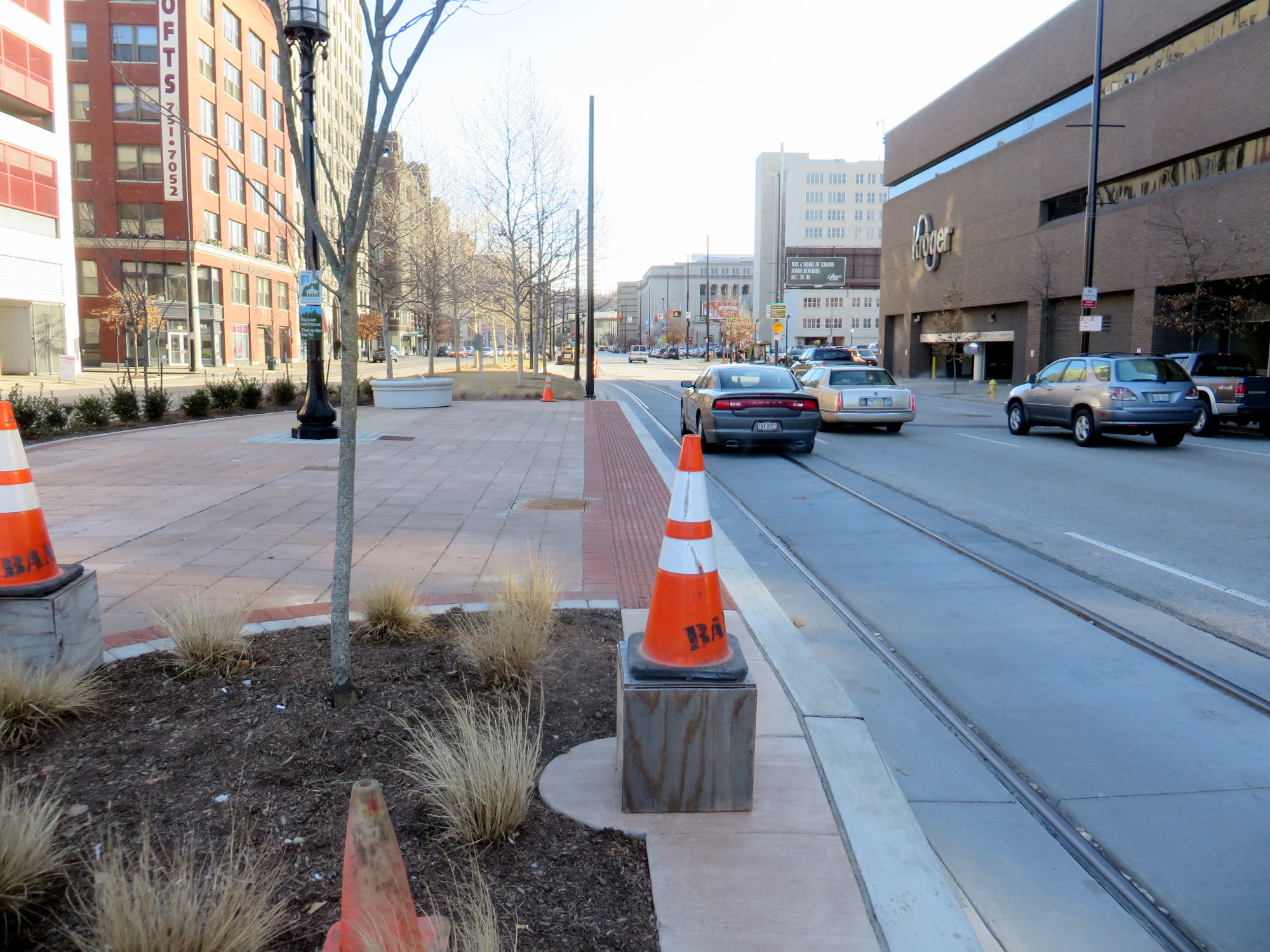 Central Parkway in Cincinnati in January 2015, where new streetcar tracks run above the abandoned subway line
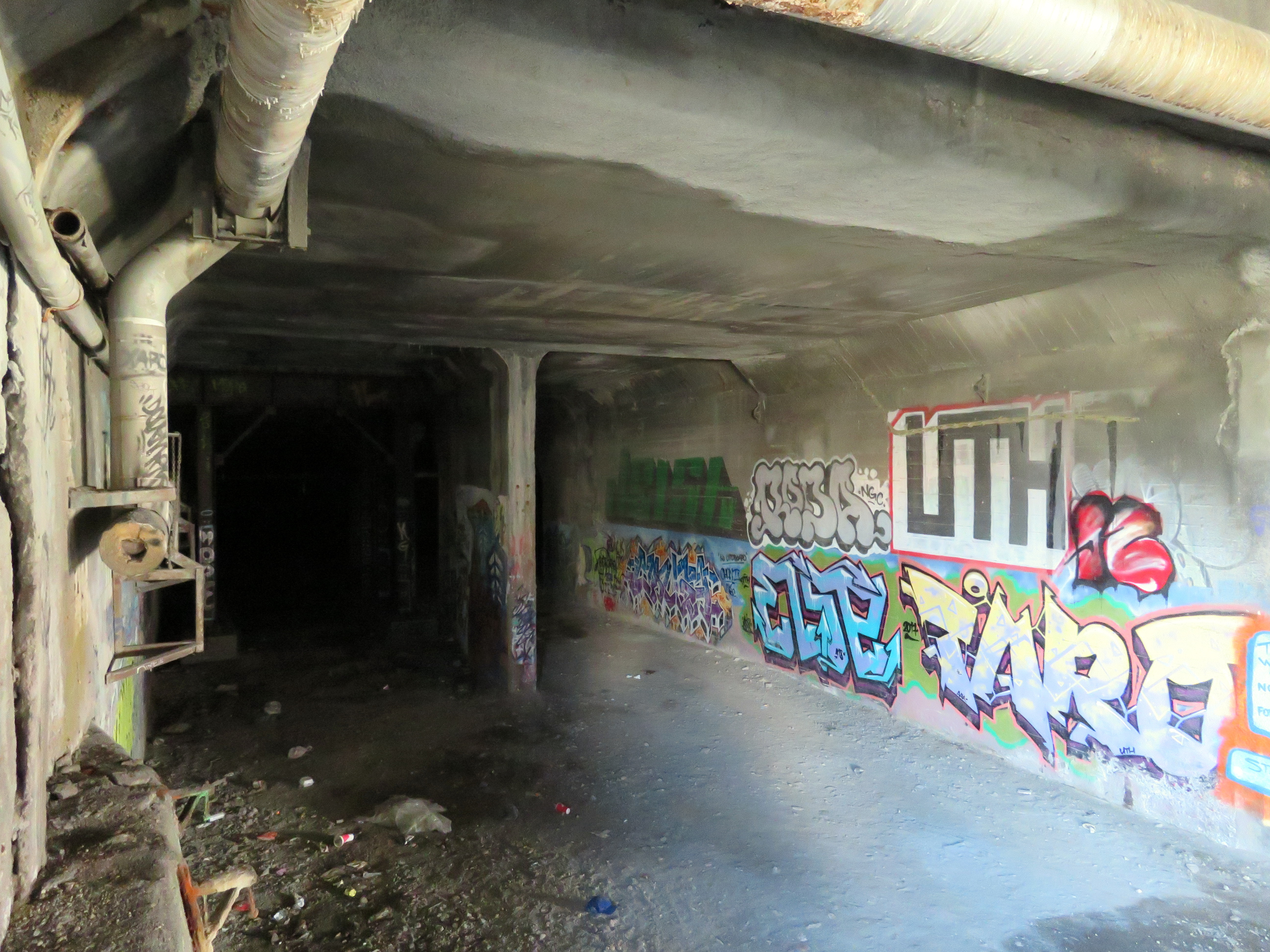
 A public walkway from the Genesee Riverway at the Broad Street Bridge allows visitors to get a glimpse of the abandoned Rochester Subway
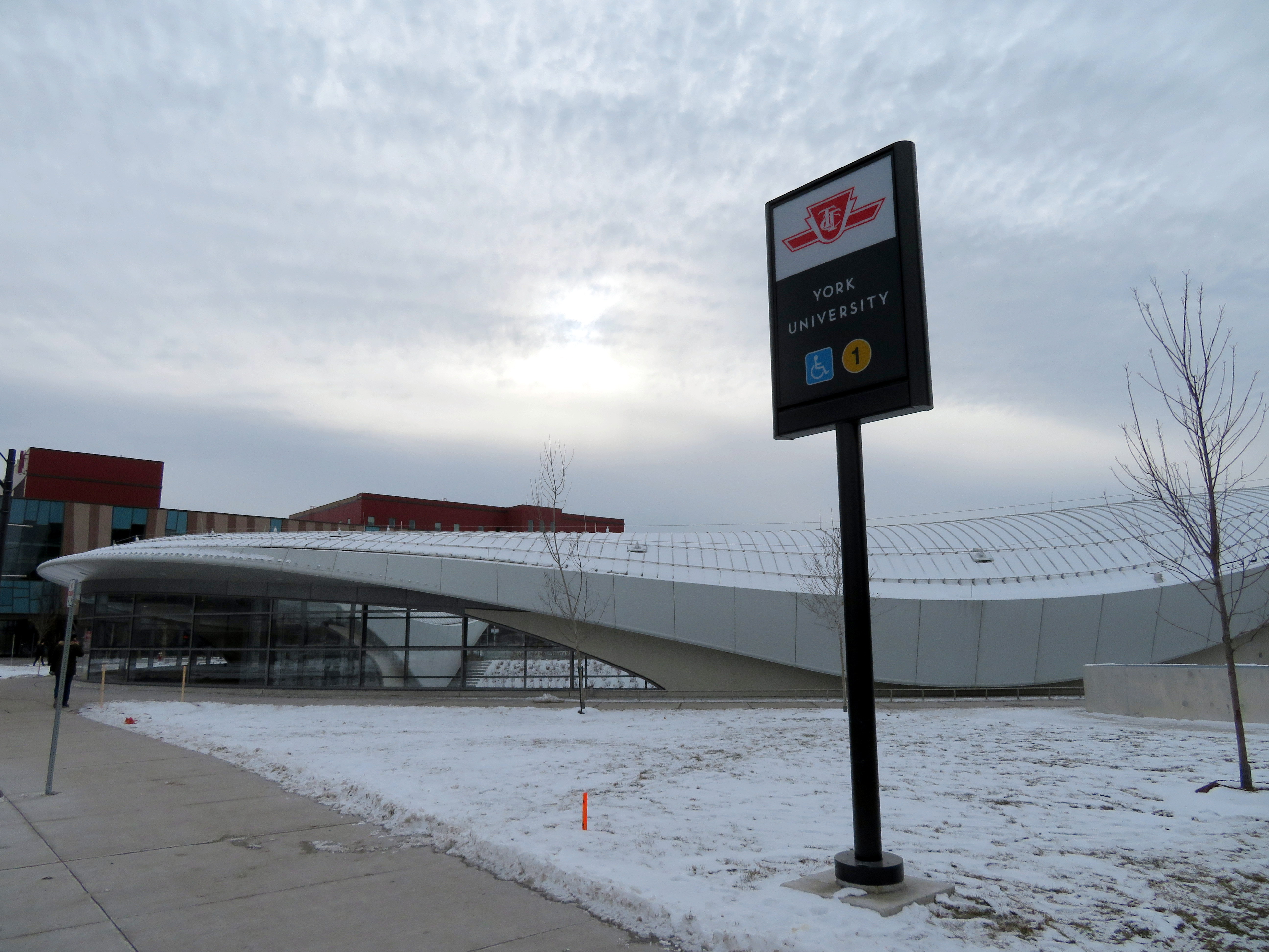
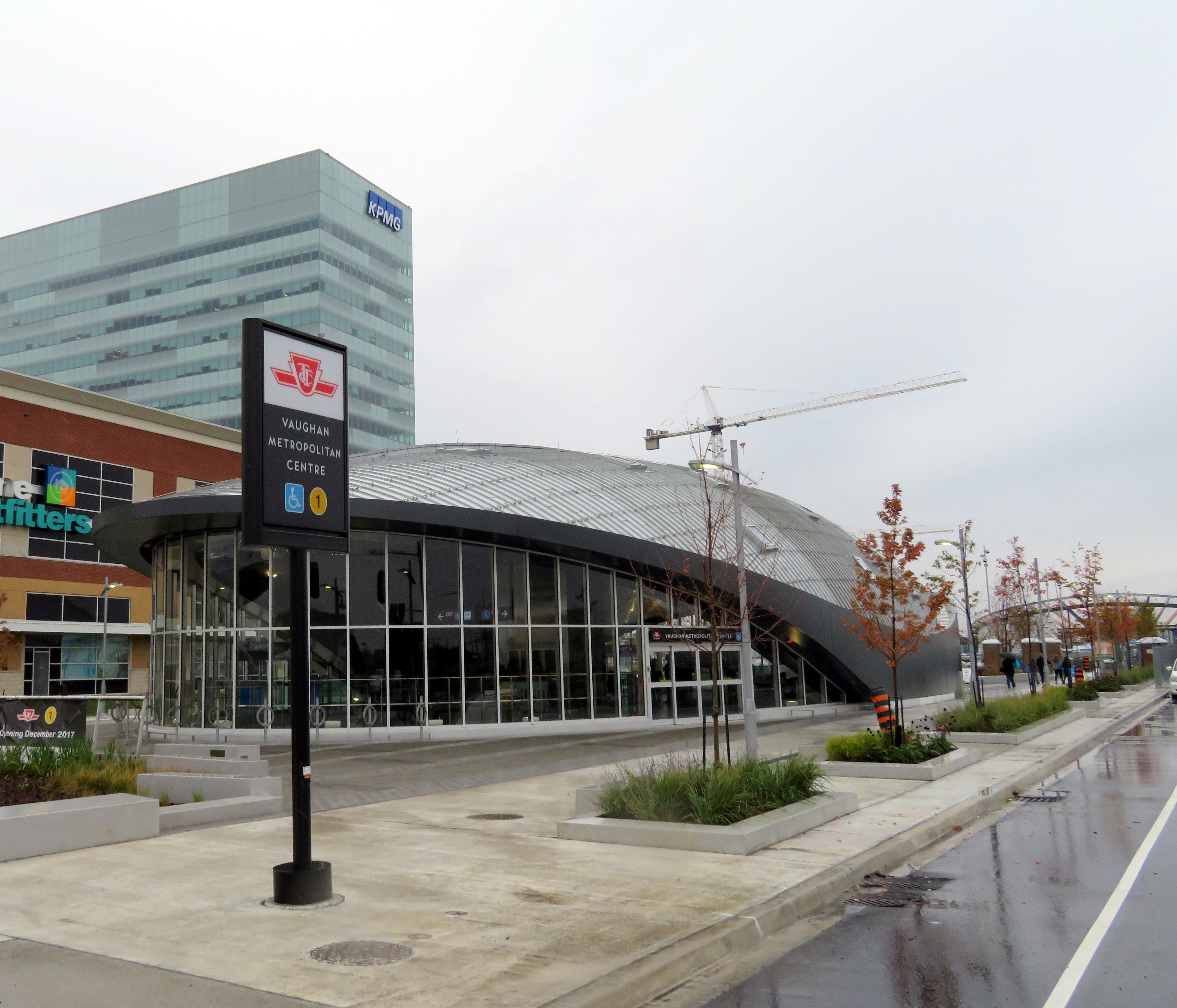 Vaughan Metropolitan Centre Station
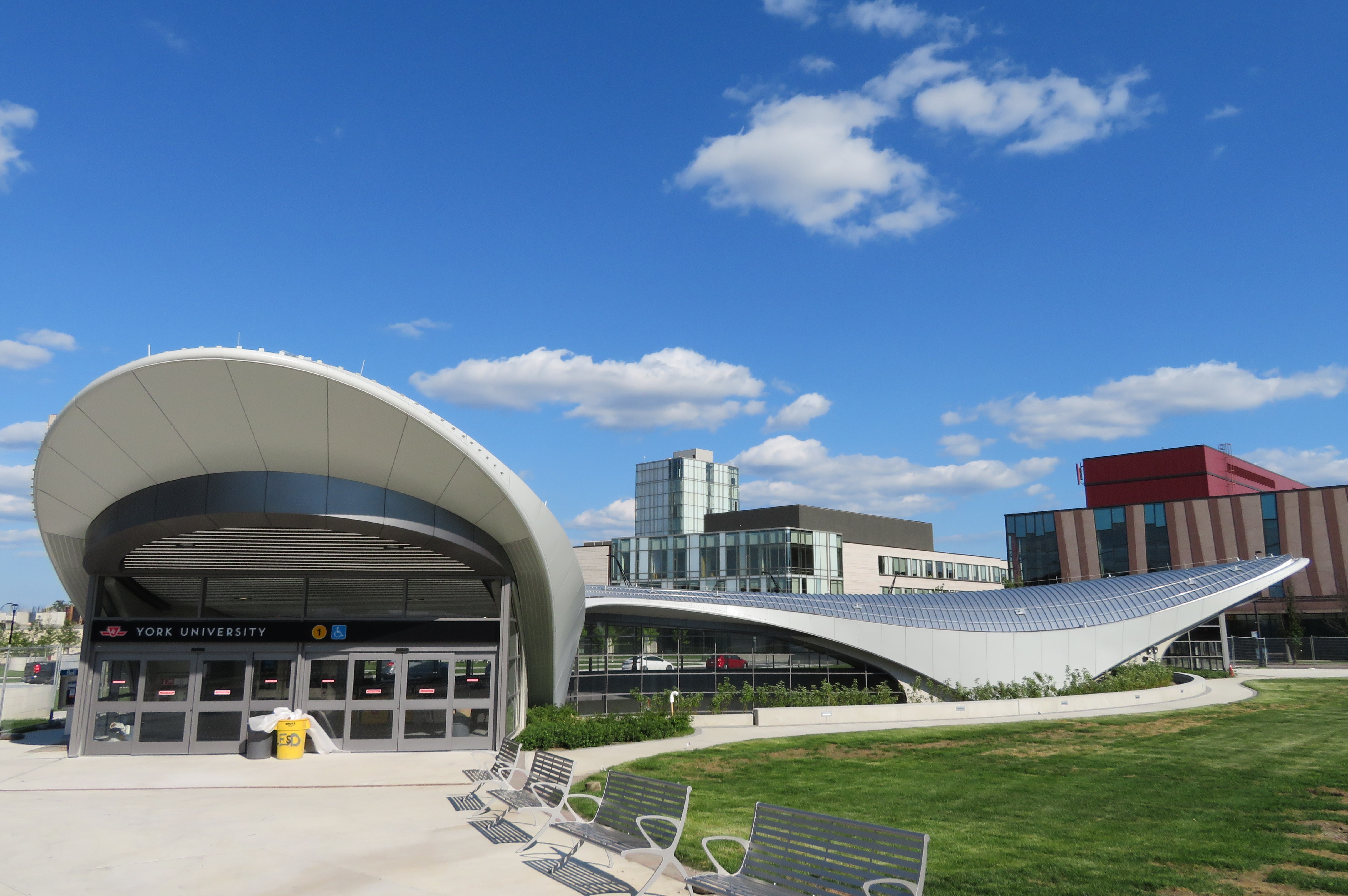 York University Station, August 2017