
Downtown Brampton, the logical terminus of the Hurontario-Main LRT
I’ve written several times about the Hurontario-Main light rail transit (LRT) project on this blog. Last summer, I led a walk along Main Street, discussing Downtown Brampton’s wonderful built heritage, the potential for Main Street, and explaining why alternative routes, proposed by councillors and private interests, weren’t feasible. Floodplains aren’t great places to build higher-order transit lines.
Needless to say, I was very disappointed that Brampton City Council voted 6-5 last October against building the LRT between Steeles Avenue and Downtown Brampton. A vocal and wealthy minority, including a former premier of Ontario, opposed the project; it didn’t help that Mayor Linda Jeffrey found herself in constant opposition with several city councillors who backed other candidates for mayor in the 2014 municipal election. A Toronto Star reporter, assigned to the western GTA beat, wasn’t reporting fairly on this issue either.
Since that unfortunate vote, I resigned myself to a truncated Hurontario-Main LRT corridor that will still serve three or four stops in Brampton, but will stop short of its logical terminus.
I recently made a trip out to the intersection of Steeles Avenue and Main and Hurontario Streets, the new northern terminus of the planned LRT. Construction of the 20-kilometre line, between Port Credit and Steeles Avenue, is scheduled to begin in 2018.

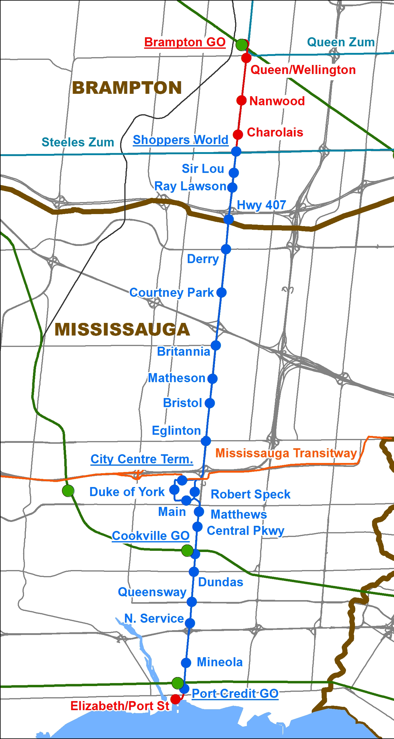
The Hurontario-Main LRT, after Brampton City Council’s vote in October 2015.
The corner of Steeles Avenue and Main Street is already a major transit hub. Eleven Brampton Transit bus routes (including two Züm routes), a Miway express bus, and GO Transit buses serve the corner; the Brampton Gateway Terminal is the city’s second-busiest transfer point. The new Gateway Terminal, which opened in 2014, was built to accommodate ridership growth and facilitate transfers with the proposed LRT, which will stop in the median of Main Street.
As far as Toronto’s suburbs go, this corner of Brampton is relatively dense. There are several rental towers within a short walking distance; there are also three nearby townhouse complexes. Shoppers World, on the northeast corner, is a large regional shopping centre, albeit a mall that has fallen on hard times. On the southwest corner, there is still an old farmfield, surrounded by subdivisions, apartment towers and retail. There are many opportunities for transit-oriented development.
 A fallow farm field, south of Shoppers World. The area is zoned for medium and high density housing developments, including townhouses and apartment buildings.
If Downtown Brampton, Brampton’s busiest bus route (501 Queen) and a GO Transit and VIA Rail station weren’t just 3 kilometres away, this would actually be an ideal terminus for a suburban light rail transit line.
 The corner of Steeles and Hurontario/Main, looking northwest. The Brampton Gateway Terminal is on the opposite corner.
One of the greatest opportunities for new transit-oriented development is Shoppers World Brampton. First opened in 1969 by Peel Elder Limited (who also developed Shoppers World Danforth), the mall went through several additions over the years; by the 1980s, it boasted over 200 stores, including a Simpson’s, K-Mart, Pascal Hardware, cinemas, and two supermarkets. At one time, Shoppers World even had indoor waterslides. By 2000, Simpsons became The Bay, and K-Mart became Zellers.
Growing up only a 15-minute walk away, Shoppers World was my local mall. Pizza Hut was a favourite place to meet up with friends, I fondly remember the free popcorn at Jumbo Video, and the bus terminal made it easy to get to better malls, particularly Square One. My first paying gig was returning abandoned shopping carts to K-Mart for $5 each.
By the 1990s, the mall’s owners neglected the property, while Bramalea City Centre and Square One renovated and expanded. There were persistent rumours that the mall would be closed and re-developed with highrise towers.
 A mostly empty Shoppers World parking lot on a Saturday afternoon.
RioCan REIT took over Shoppers World Brampton in 2000, renovated the property, and added new big-box retailers such as Canadian Tire. But The Bay closed in 2007, and Target, which took over Zellers’ lease, shut down last year. The final indignity came when the shuttered Bay store was torn down and replaced by Lastman’s Bad Boy.
Shoppers World isn’t yet a dead mall – while many national chains left in the last two decades, small businesses have moved in. However, there are still plenty of vacancies, especially in the north end of the mall, near where The Bay used to be. The new Bad Boy and Beer Store are accessed only from outside the mall, making it harder to draw customers in.
 The former mall entrance to Target, showing the floor tiles installed in the 2000-2002 renovations.
The answer, I think, is to partially redevelop Shoppers World into a mixed-use, transit-oriented development, retaining a majority of the retail space, but including new residential, office and community uses. Shops at Don Mills, at Don Mills Road and Lawrence Avenue in Toronto, isn’t a bad model to follow, but better residential integration and a proper link with the transit hub would be necessary. Humbertown, a smaller, but controversial development proposed for Etobicoke, has the right mix of retail and residential intensification.
One day, I believe a new Brampton City Council will come to its senses and get the LRT extended to Downtown Brampton as proposed. This is what happened in Mesa, Arizona, a Phoenix suburb that originally opposed a light rail corridor from Downtown Phoenix, Tempe, and Arizona State University, to its downtown. After the first phase of the Valley Metro LRT opened in December 2008, political opposition to a light rail extension along Main Street faded. The LRT through Downtown Mesa opened to great fanfare in August, 2015.
But until that time comes, there are some opportunities to capitalize on the approved plan. Steeles Avenue isn’t the ideal place to end the Hurontario LRT, but it’s a good place to start planning something better.
 Bramalea GO Station
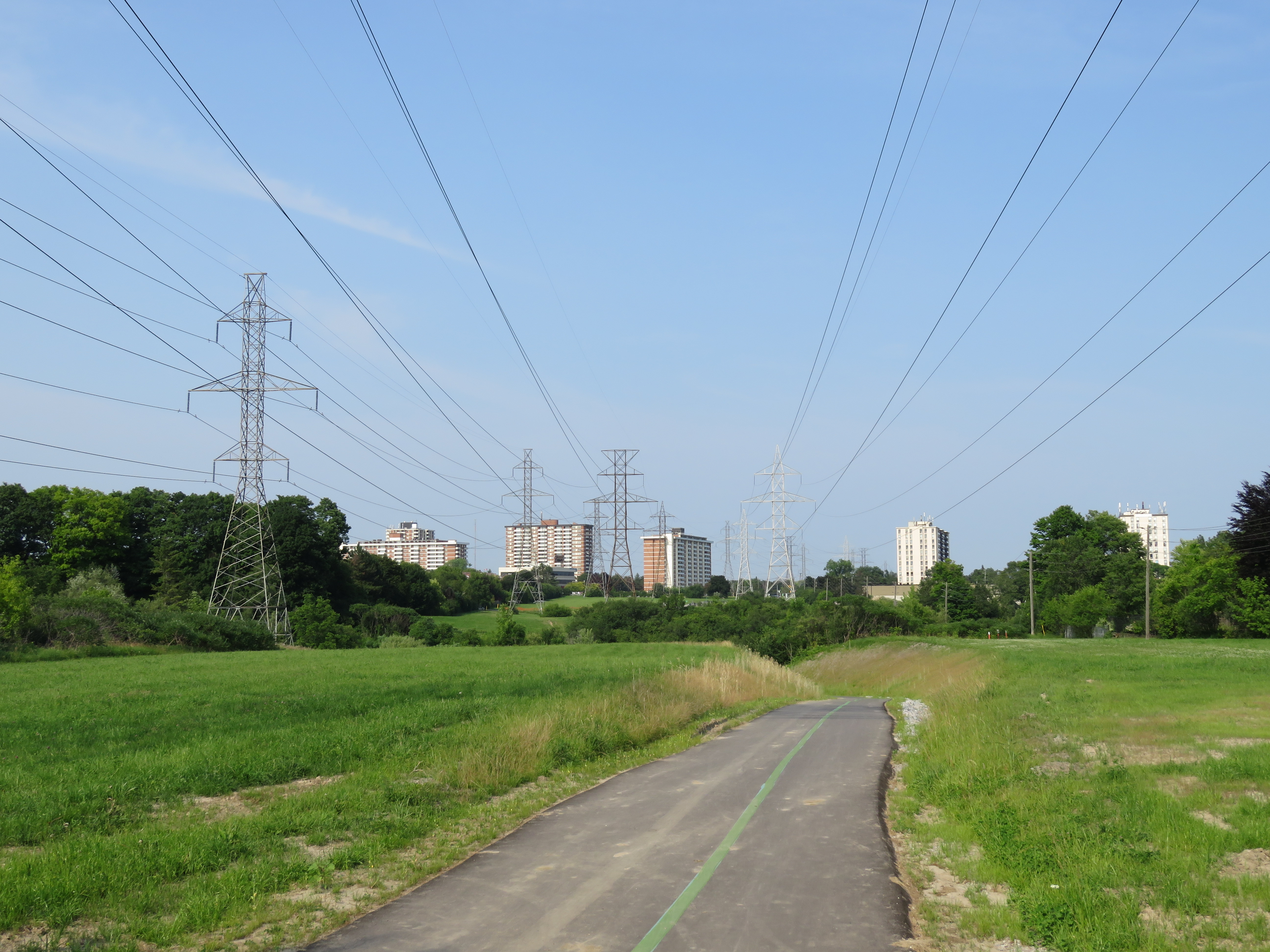
 New office development at the TTC York Mills Station parking lot
 Route 107 Malton Express bus on the Mississauga Transitway at Tomken Station
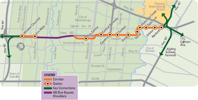


 Screenshot from the classic Simpsons episode