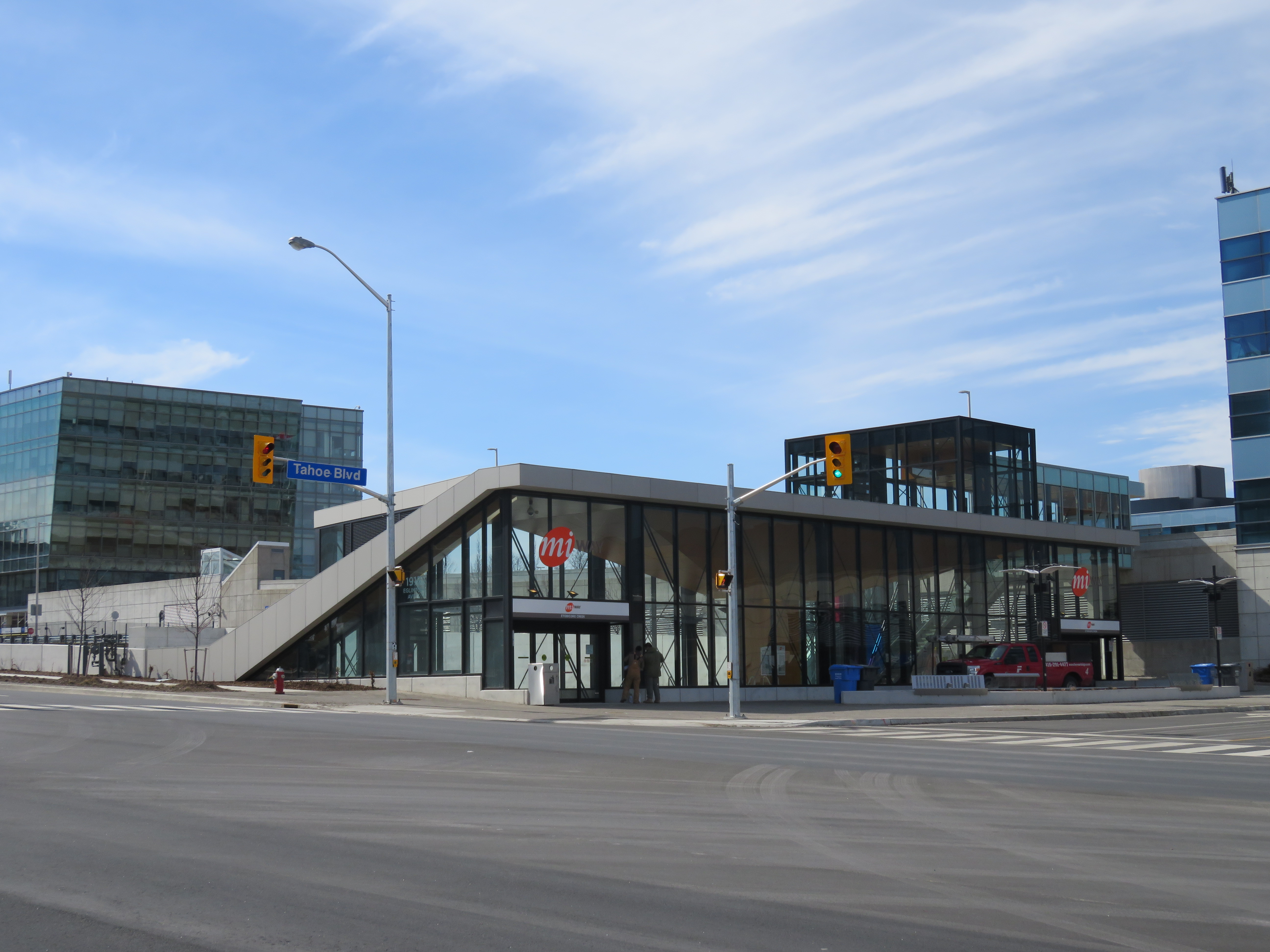
 Route 107 Malton Express bus on the Mississauga Transitway at Tomken Station
After riding the UP Express back in March, the inspiration for a post on a proposed transit hub at Toronto Pearson International Airport, I went for a ride on the Mississauga Transitway.
I first rode the Mississauga Transitway on a snowy Monday, November 17, 2014, the day it opened. At the time, only four stations were opened — Central Parkway, Cawthra, Tomken, and Dixie. On my first visit, I was unimpressed. But I decided to give it another try after the two new stations opened, on a Saturday, when I had plenty of time to check out the service, the new stations, and the environs.
I have many thoughts and criticisms about this new piece of transit infrastructure, which will cost the City of Mississauga and Metrolinx a combined $528 million.
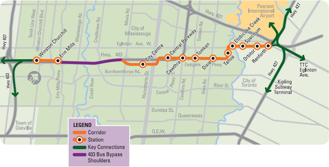 Map of Mississauga Transitway, taken from the GO Transit website
What is the Mississauga Transitway?
The Mississauga Transitway is a bus rapid transit (BRT) project. BRT is a term used in the transit industry to describe everything from limited-stop conventional buses, perhaps with some perks like all-door boarding and queue-jump lanes sometimes called BRT-lite (Brampton Zum is a good example), to fully grade-separated, high speed bus corridors that operate like metro lines (the Ottawa Transitway and Bogota’s TransMillenio system are good examples). Other busways in Canada include the Ottawa Transitway, to be partially replaced by light rail transit, the Gatineau Rapibus corridor, York Region’s Viva Rapidways, and Winnipeg’s RT corridor.
The Mississauga Transitway is a true BRT system, but it has several major weaknesses.
The Mississauga Transitway corridor follows Highway 403 and a major power transmission line, but serves Mississauga City Centre, home to Square One — Ontario’s largest mall — City Hall, a Sheridan College campus, as well as several office buildings and thousands of residents. It’s also the main hub of MiWay’s transit system.
The Mississauga Transitway has been proposed since the 1980s, when Mississauga became a city. From the 1960s onward, Mississauga grew as a bedroom community for Toronto, but employment grew thanks to good highway connections and being the home of Pearson International Airport. In 2015, there were 420,500 workers employed in Mississauga, nearly the same as the city’s working-age population. Thousands of workers commute to Mississauga from Toronto every day by car and by bus. (GO Transit’s rail lines are well suited to ferrying commuters to Downtown Toronto, but not so great for most other trips.)
Originally part of a regional rail corridor called GO-ALRT, the Mississauga Transitway alignment was first proposed in the 1980s. The map below, from a planning report and found on the Transit-Toronto website, shows the proposal in 1992. Early plans called for a completely separate bus-only road, and an underground bus tunnel under Renforth Avenue under Square One, and sixteen stations in total. At Renforth Station, connections would be made to GO Transit and TTC buses (possibly by an extension of the busway eastward along the Richview transportation corridor to the then planned Eglinton West subway).
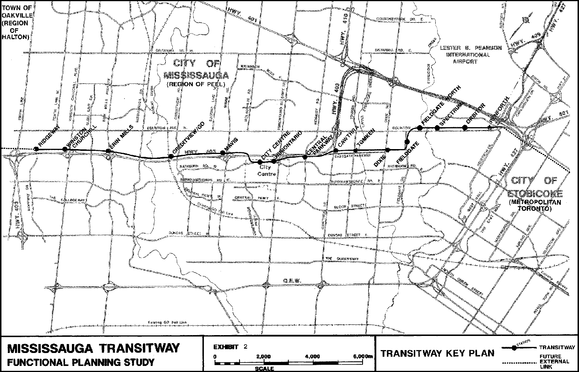
1992 Mississauga Transitway alignment map. More detail can be found here.
The Transitway project has since been value-engineered to cut costs. The underground tunnel was cut. The transitway between Square One and Erin Mills Parkway, as well as stops at Mavis and Creditview (with a possible connection to the Milton GO line), were eliminated.
When completed, the Transitway will have twelve stations in total, from Renforth Gateway Station in the east, to Winston Churchill Station in the west. On February 16, 2016, Tahoe and Etobicoke Creek Stations opened, bringing the total number of completed stations to six.
The eastern section of the Transitway, between Between Hurontario Street and Renforth Drive, is partially open, six stations are now open, three more are under construction. In Mississauga City Centre, buses operate on Rathburn Road and Centre View Drive, serving the main City Centre Transit Terminal adjacent to Square One.
Between Mississauga City Centre and Erin Mills Parkway, buses simply take Highway 403, which has wide paved shoulders that buses can use in heavy traffic. A short western section of the Transitway is under construction between Erin Mills Parkway and Winston Churchill Boulevard; Erin Mills Station is open and served by several GO Transit bus routes.
 Current service pattern on the Mississauga Transitway, showing connections. From the MiWay website.
As of April 2016, only three MiWay routes operate on the Transitway — Route 21, a rush-hour industrial route, and two express bus routes: Route 107, which operates between Square One, the Viscount LINK Station at Pearson Airport and Westwood Mall in Malton, and Route 109, which runs between Meadowvale, Square One, and Islington Subway Station. Routes 107 and 109 do not operate on Sundays.
What’s right and what’s wrong with the Mississauga Transitway?
Bus rapid transit is a relatively cost-effective way of providing reliable and faster transit services; buses can be routed on and off the corridor to provide local service or as part of a plan for gradual implementation. Routes 107 and 109 continue past the busway corridor to serve important anchors such as Pearson Airport, Meadowvale Centre, Westwood Mall, and Islington Subway Station. The Airport Corporate Centre is a major employment area, and the Transitway runs right past it.
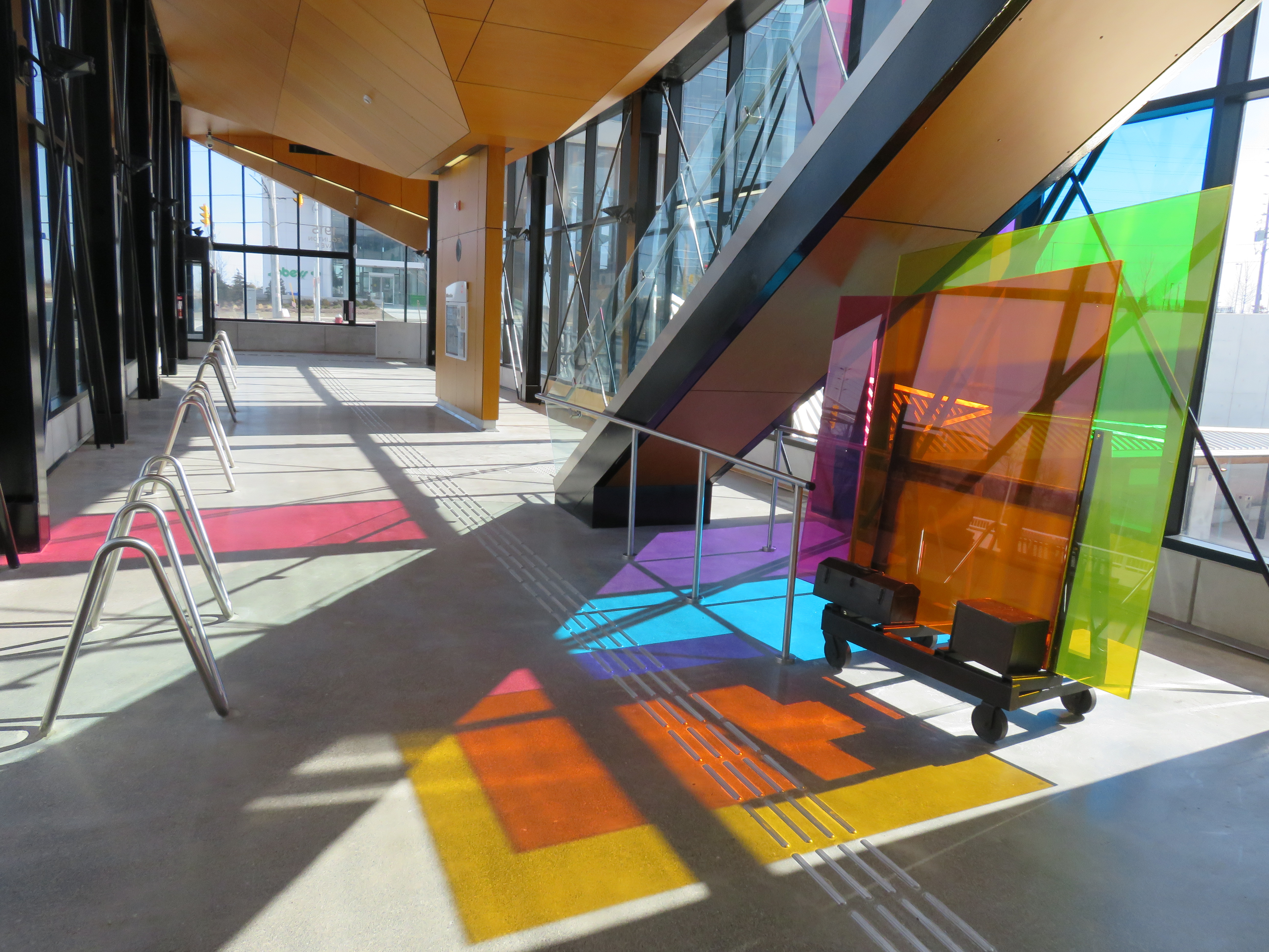
 Etobicoke Creek Station, my favourite completed Transitway stop.
Transitway stations on the east corridor are attractive, fully accessible, and are designed for growth. The new Etobicoke Creek Station is integrated with adjacent office developments. Once service is fully implemented, the Transitway will be an essential part of MiWay’s plan to re-structure its hub-and-spoke system of meandering routes to a grid system. MiWay Five, as the plan is called, is a very good plan to make transit quicker and more direct. Several routes will be removed from the overcrowded City Centre Terminal; many passengers will connect instead at Transitway stations.
But the Mississauga Transitway’s problems lie in its isolation, limited opportunities for transit-oriented development along the corridor, difficulty of accessing many of the stations, and poor transfer opportunities to connecting bus routes.
The corridor and the “last-mile” problem
 The Mississauga Transitway looking east from Tomken Station, March 2016
The Transitway is located in a hydro corridor and uses Highway 403. It’s a convenient and direct corridor between Mississauga City Centre and the Airport Corporate Centre, but the surrounding land uses make it nearly impossible to generate any walk-up traffic. Cawthra Station has a small pick-up and drop-off location, as well as 60 parking spaces, but has no bus connections, nor any trip generators.
Because of 1970s/1980s subdivision design of residential areas to the south, Tomken Station is difficult to access for nearby residents. What should be a two or three minute walk from the nearest homes becomes an awkward 9 or 10 minute hike. North of Tomken Station, the sidewalk disappears from the west side of the street, the same side where the station entrances are located. The Transitway is dependent on drive-up traffic and bus connections.
The walk from Tomken Station to the nearest house.
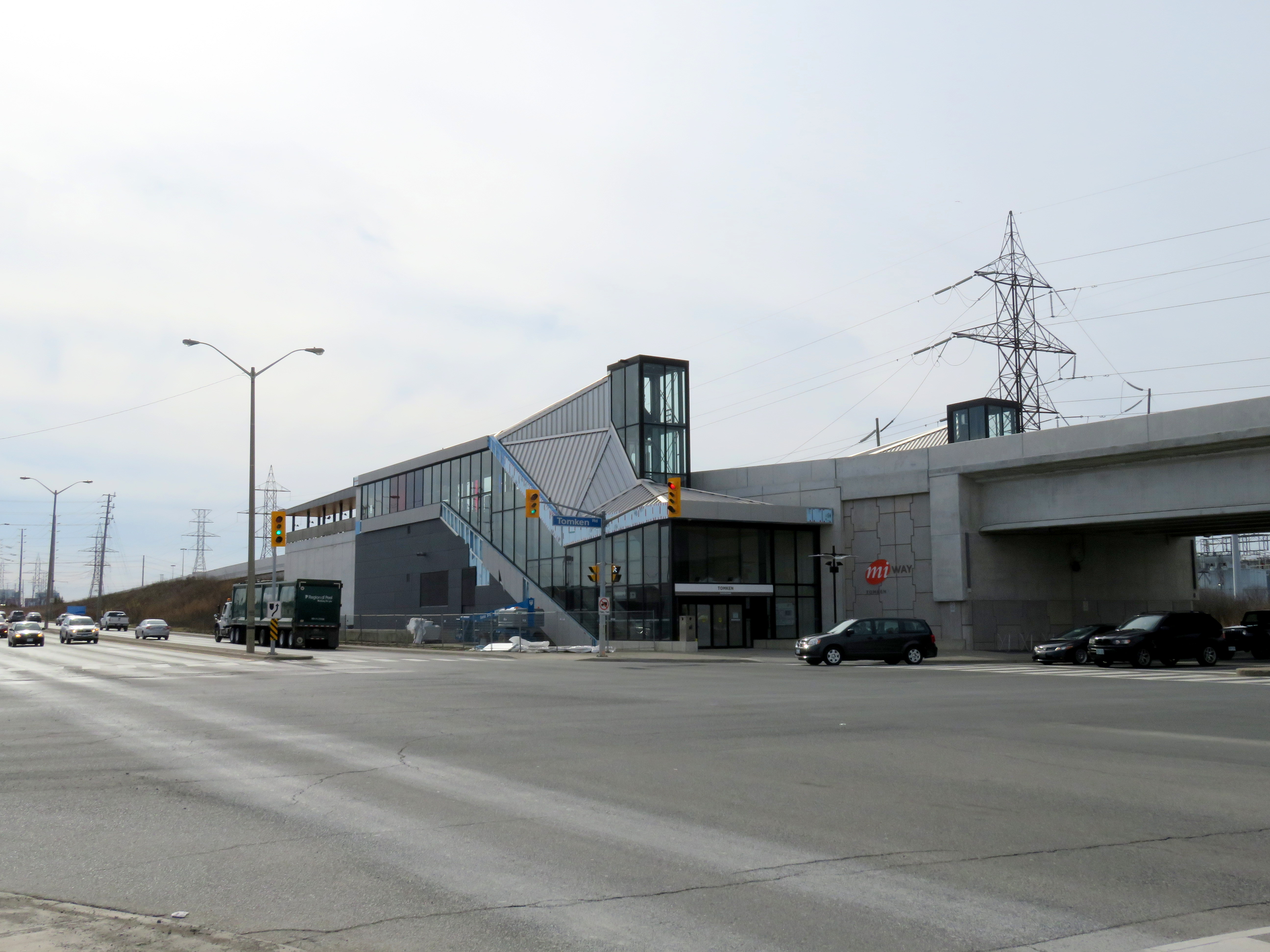
 Tomken Station and surrounding area, March 2016
In the Airport Corporate Centre, the Mississauga Transitway skirts the south side of the large business park, beside Eglinton Avenue, while many of the office buildings are further north, adjacent to Highway 401. This is a problem of urban planning more than anything; it’s an area built for the car and difficult to serve with transit. This is known as the “last mile problem.” Shuttle buses will be necessary to connect Transitway passengers to many of the jobs located in this area, a problem I discussed earlier about a proposed transit hub at Pearson Airport.
Airport Corporate Centre
Mississauga City Centre
 Loading on the street at the City Centre Transit Terminal
The most congested part of the Transitway is the section where buses use Rathburn Road, where there is no transit priority. It’s a critical link to GO Transit, Brampton Zum, and, eventually, the Hurontario-Main LRT. Traffic destined for the mall can cause serious congestion here, especially on weekends and before Christmas. It’s the weakest link.
Ottawa’s Transitway has a similar problem on Albert and Slater Streets. Canada’s capital city is solving that problem by building a LRT tunnel under the city centre.
Connections with local bus routes
By using Highway 403 instead of a dedicated busway between City Centre and Erin Mills, the opportunity to connect with bus routes on Creditview and Mississauga Roads is lost. Further east, this is not a problem due to the dedicated roadway and frequent stations.
Erin Mills Station

 Approach to Erin Mills Station, surrounded by hydro lines, a freeway, and backyards.
Erin Mills Station, which was constructed by Metrolinx and not the City of Mississauga, was in the news recently as local residents were upset with noise, privacy concerns, and the unsightliness of an utility building constructed adjacent to residents’ backyards. Unfortunately, the Toronto Star (as well as the City of Mississauga, which took on the residents’ complaints) only discusses locals’ concerns, and not the deeper land-use and design problems.
The station, which is currently served by GO Transit buses to York University, Hamilton, Guelph and Kitchener-Waterloo, is located in an isolated area, even more so than some of the eastern Transitway stations. Erin Mills Station is surrounded by hydro-electric power lines, Highway 403, and the backyards of single-detached houses. The station site discourages walk-up traffic as well as cyclists. It is difficult to access without a car. For now, even bus connections to other bus routes are poor or nonexistent, though the MiWay Five plans will see it become a major hub. This is poor urban planning. The major trip generators in the area — Credit Valley Hospital, Erin Mills Town Centre, high schools, are to the north, at Eglinton Avenue. Again, transfers will have to be made here to reach those important destinations.
If I had my way, instead of building noise walls to address the residents’ complaints, I would buy the residents out and build higher-density, mixed use developments here.
 Erin Mills Station
Conclusions
Gil Penalosa, of 8-80 Cities, described the transitway as “doing the right thing, but not doing things right.” He makes very good points, and I believe that there were several crucial mistakes made over the last few decades that could have made for a more useful transit corridor. Penalosa argues that the busway should have followed Burnhamthorpe Road. I don’t agree — Burnhamthorpe is lined with suburban backyards, and doesn’t connect well with employment areas — but the Transitway was built on the wrong corridor, and urban planning failed to support the long-planned major transit route. I wouldn’t all it a white elephant yet. Once service ramps up, and MiWay Five is fully implemented, it might become well-used.
The intentions behind the Transitway are good, and there are some important benefits, such as supporting a grid-based transit system, improving commute times between major hubs, and improving transit access to employment centres. But it fails to facilitate transit-oriented development. It doesn’t serve places where people are, nor does it relieve existing high-demand transit corridors. And the corridor that it runs through will not support much TOD. The value engineering aside, the Transitway is a nice piece of transit infrastructure, too bad about where it’s located.
I’m much more optimistic that the Hurontario-Main LRT, which will replace one of the busiest bus routes outside of the City of Toronto, will achieve these goals. There are also opportunities for higher-order transit on Dundas Street, another busy street with many opportunities for urban intensification. Mississauga’s Dundas Connects project is focused on these opportunities and is looking to engage the public.

Leave a comment