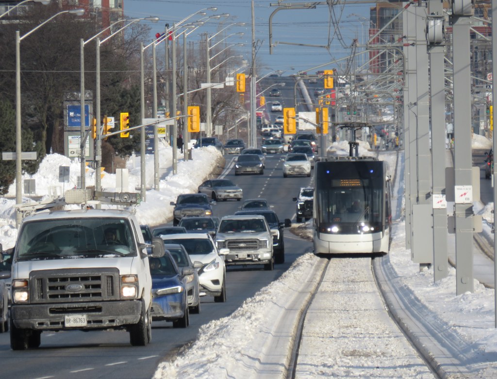
A westbound LRV train on Eglinton Avenue in Scarborough, January 2026
After fifteen long years, the wait is over. On Sunday, February 8, the Eglinton-Crosstown LRT will finally open to the public, with the first train leaving Kennedy Station at 7:00 AM. (The first eastbound train will depart Mount Dennis at 7:07 AM.) Rides will be free on that first day, but there will be no opening celebration, no ribbon cutting, and no giveaways. At first, trains will run until 11 PM, with Line 5 shuttle buses from 10 PM until 1AM, when the 334 night bus takes over.
After the botched opening of Line 6 Finch West, it is clear that no one in charge wants to celebrate the opening of this new transit line after years of construction delays and false hope of completion in 2020, 2021, 2022, 2023, 2024 and 2025. So if you want to check out Toronto’s new ride, go do it at your own convenience. You won’t miss anything.
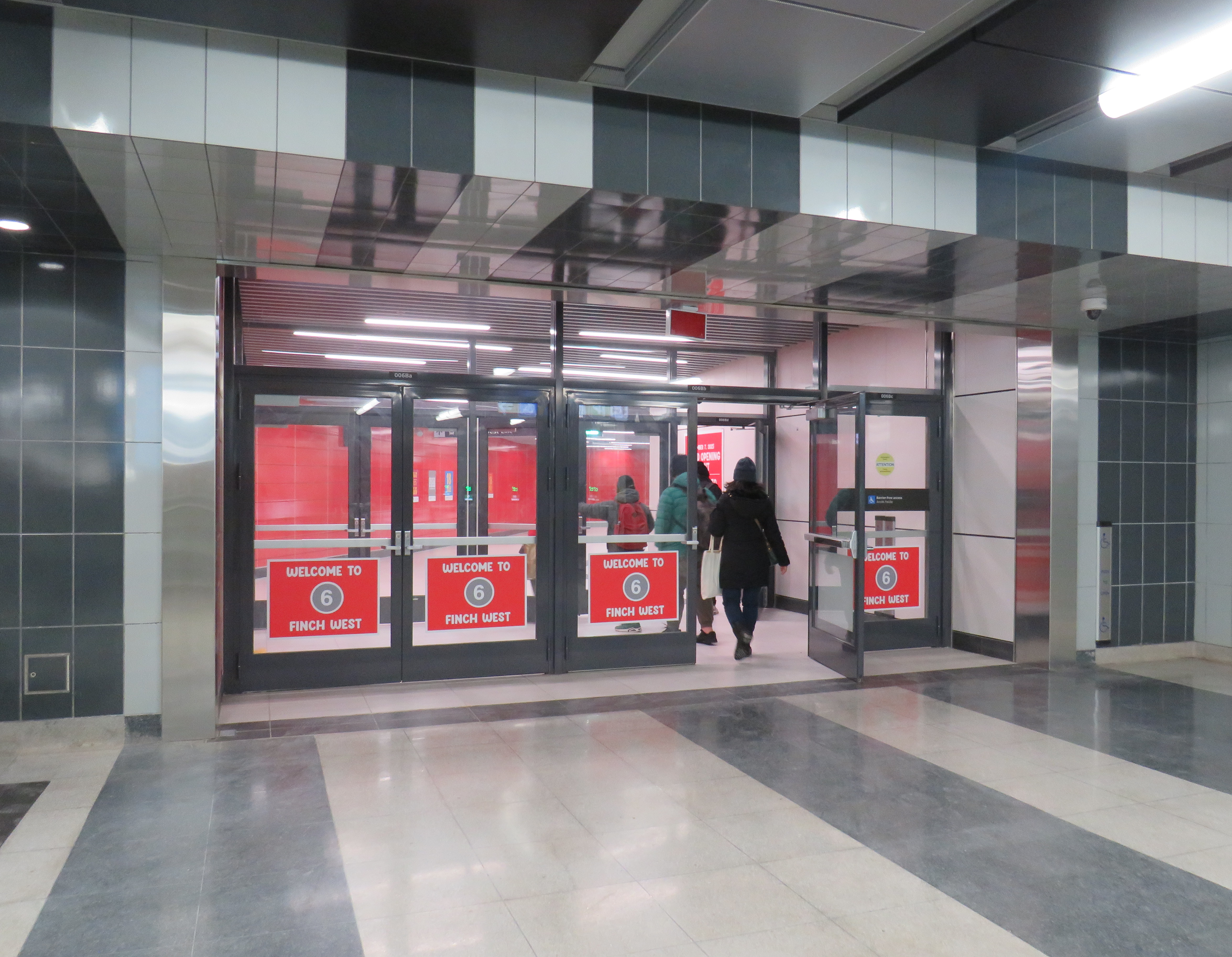
There will be no party, like the one arranged last December at Finch West
But even if the trains run slower than originally planned at first, there should be a ramping up of speeds and transit priority in the surface-running eastern section. The tunneled section will have speeds up to 60 km/h between stations, making it considerably faster than the buses it will replace. During a visit to Scarborough last month, it already seemed that trains were running a bit faster in the outdoor section than on Finch West, so there’s definitely some reason to welcome the LRT in its initial “soft opening” phase.
The TTC notes that once full service is operational later in 2026, the end‑to‑end travel times will be “approximately 50–55 minutes.” That’s about twice as fast as the bus when going all the way from Mount Dennis to Kennedy. Perhaps, once the trains are running on a full schedule until 1AM and with expected performance improvements, there will be a formal ceremony to conclude this long journey.
Notably on Sunday February 8, there will be significant changes to the bus network, including 2 discontinued routes, 13 route changes, and 4 new routes. Most notably, Routes 54 and 954 on Lawrence Avenue East will now terminate at Don Valley Station instead of at the subway at Eglinton Station. Route 35 Jane will no longer continue south of Weston Road, but will instead terminate at Mount Dennis (with new Route 27 Jane South taking over that southern section). The 47 Lansdowne will be split into two, with 18 Caledonia providing service north of Eglinton. Routes 51 Leslie and 56 Leaside will be merged (with a short 151 Leslie North bus on the north end), and the 32C branch will be replaced with the new 158 Trethewey bus. The map below shows how the TTC buses will connect with Line 5. (Route 901, between Mount Dennis Station and Pearson Airport via Dixon Road, has not yet been approved.)
Map showing TTC bus route changes; several of these were already implemented in late 2025. Only the 901 express route to Pearson Airport has not been approved.
I will certainly make time to check out Line 5 on Sunday, followed by a more fulsome review a week or two after opening to form an honest and thoughtful opinion.
With planning now well underway for the Alto high speed passenger rail corridor between Quebec City and Toronto, there has been some speculation that Ottawa’s grand old Union Station, in the heart of the capital’s downtown core and a mere stone’s throw from Parliament Hill, could see trains again. Local business leaders and Mayor Mark Sutcliffe are excited by the idea of a downtown station, expecting that a downtown transport hub would help revitalize the local economy. Though it’s a very attractive idea, there are unfortunately just too many reasons why this would not be feasible.
To understand why, it’s worth diving into the history and urban politics of railways in the National Capital Region.
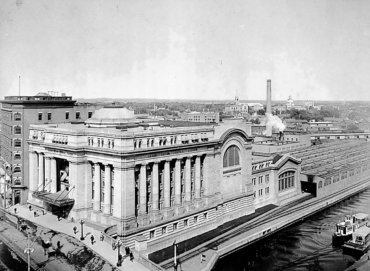
The Grand Trunk Central Station, opened in 1912, provided a grand entrance to Canada’s capital city that was previously served by a few smaller stations just outside the downtown core. The station, designed in the Beaux-Arts style, was built as a stub-end terminal. This meant that trains would arrive and depart from the south and would have to be backed up to change direction. This suited the Grand Trunk Railway just fine, as it lined up perfectly with its route to Montréal via Alexandria (still used by VIA Rail today). The railway also built a hotel across the street — the Chateau Laurier — and connected the station with the hotel with a pedestrian tunnel.
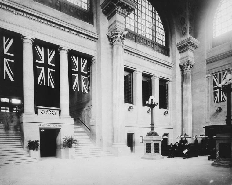
Entrance lobby, soon after opening. Note the tunnel under the staircase to the Chateau Laurier. (Library & Archives Canada)
The 1912 station was intermodal from the very beginning. Right outside the station’s front doors, there were Ottawa Electric Railway streetcar platforms serving several routes on Rideau and Sparks Streets, the two main commercial corridors in Downtown Ottawa. Right below the canal and railway bridge next to the station was the Hull Electric Railway’s loop; its streetcars crossed into Ontario via the Alexandra Bridge.
The Alexandra Bridge carried CPR trains, Hull streetcars, pedestrians, and motor vehicles when it opened in 1901
Soon after opening, the Canadian Pacific Railway joined the Grand Trunk, resulting in the terminal being renamed Union Station; the short-lived Canadian Northern Railway (CNoR) soon followed. As the CPR’s tracks to Hull (via the Alexandra Bridge) ran next to the GTR’s station, it suited the CPR well. Unlike Grand Trunk, both the CPR and CNoR had direct lines to Toronto.
Two platforms on the west side of the station allowed through CPR trains to continue towards the Alexandra Bridge and even return to Ottawa via the Prince of Wales Bridge to the west; this was the route the iconic Canadian train between Montréal and Vancouver took when it was inaugurated in 1955. Most trains — including all GTR and CNoR, however, terminated at the six stub-end tracks. Both GTR and CNoR were absorbed into the new Canadian National Railway (CN) by 1922.
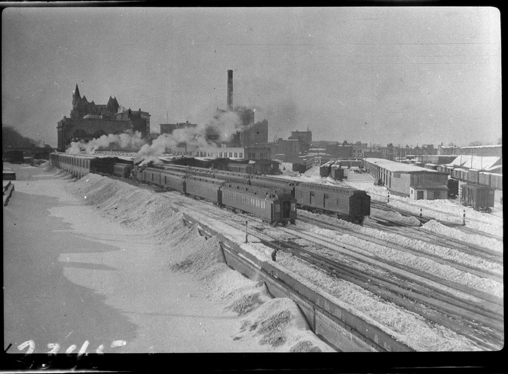
Approach tracks and Bush trainshed, Ottawa Union Station. A wintery scene, with a frozen Rideau Canal on the left. The yards at right are now occupied by the Rideau Centre, Convention Centre, and Department of Defense Headquarters (Library and Archives Canada)
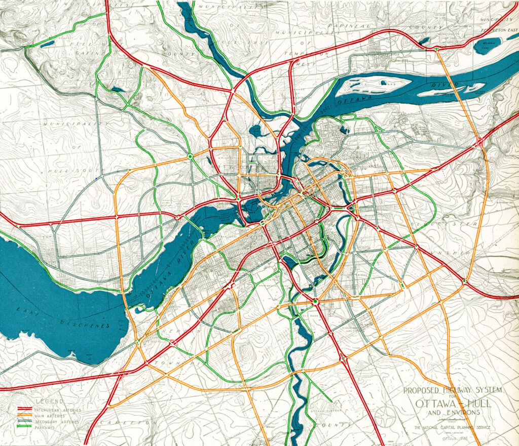
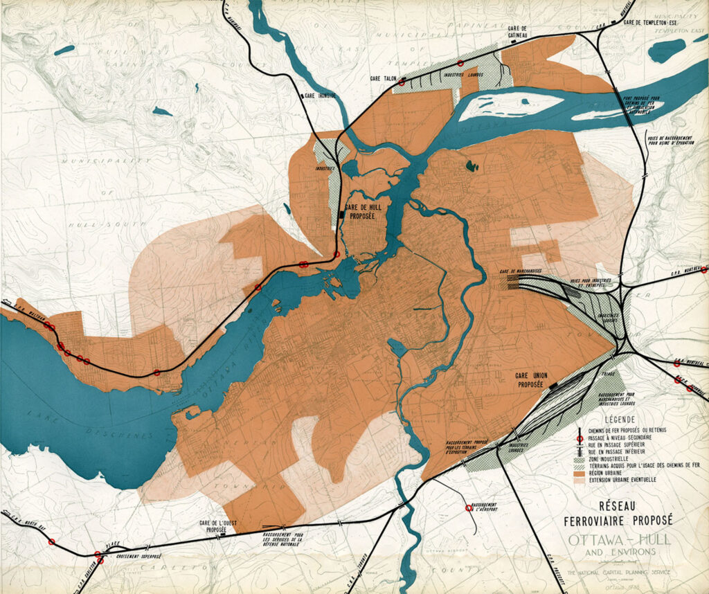
In the 1940s, the federal government led by Liberal prime minister William Lyon Mackenzie King wanted to beautify the nation’s capital region and address traffic congestion. Ottawa — and the federal government — was rapidly growing, while political leaders wanted a cityscape that matched the ambitions of an expanding nation. French urban planner Jacques Gréber was commissioned to plan the region’s future; Gréber’s recommendations, released in 1950, were ambitious and transformative. (You can read the entire report here.)
The Gréber Plan — formally titled “Plan for the National Capital” — called for new highways, the abandonment of Ottawa’s streetcars (which were seen as antiquated with unsightly overhead wires), and the removal of all railway infrastructure within the City of Ottawa. The old CN and CPR lines would make way for new roads, including a four-lane arterial along the east side of the Rideau Canal, leading to a new road bridge replacing the Alexandra. A new railway bypass along the periphery of the city would replace all urban trackage, with a proposed new Union Station site in Gloucester Township, south of Walkley Road. Most industrial uses — including the historic paper mills along the Ottawa River — would be moved to the new railway line.
Proposed highway system for Ottawa-Hull and environs, from Gréber’s reportProposed Railway system: Ottawa Hull and environs from Gréber’s report
Though the plan was not fully implemented, it did set the stage for much of the urban planning and infrastructure changes during Ottawa’s next fifty years. The railway bypass was constructed between Bell’s Corners in the west and Ramsayville in the east, with the old Grand Trunk tracks through the city replaced with The Queensway, now part of Highway 417. New parkways lined the rivers and canals. Two new multilane traffic bridges crossed the Ottawa River (though the Alexandra Bridge was maintained for traffic and pedestrians) and Albert and Slater Streets were made one-way, with a new bridge over the Rideau Canal (the Mackenzie King Bridge) linking them to the east. A large Greenbelt encompassed the city region, intended to direct growth while preserving natural areas.
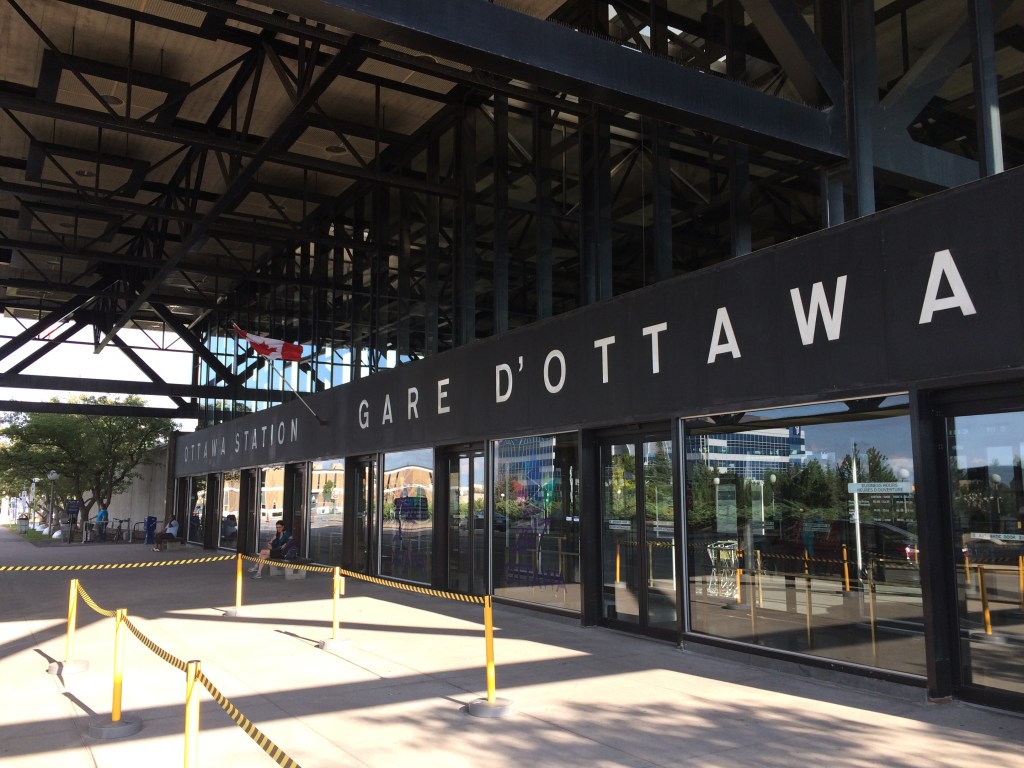
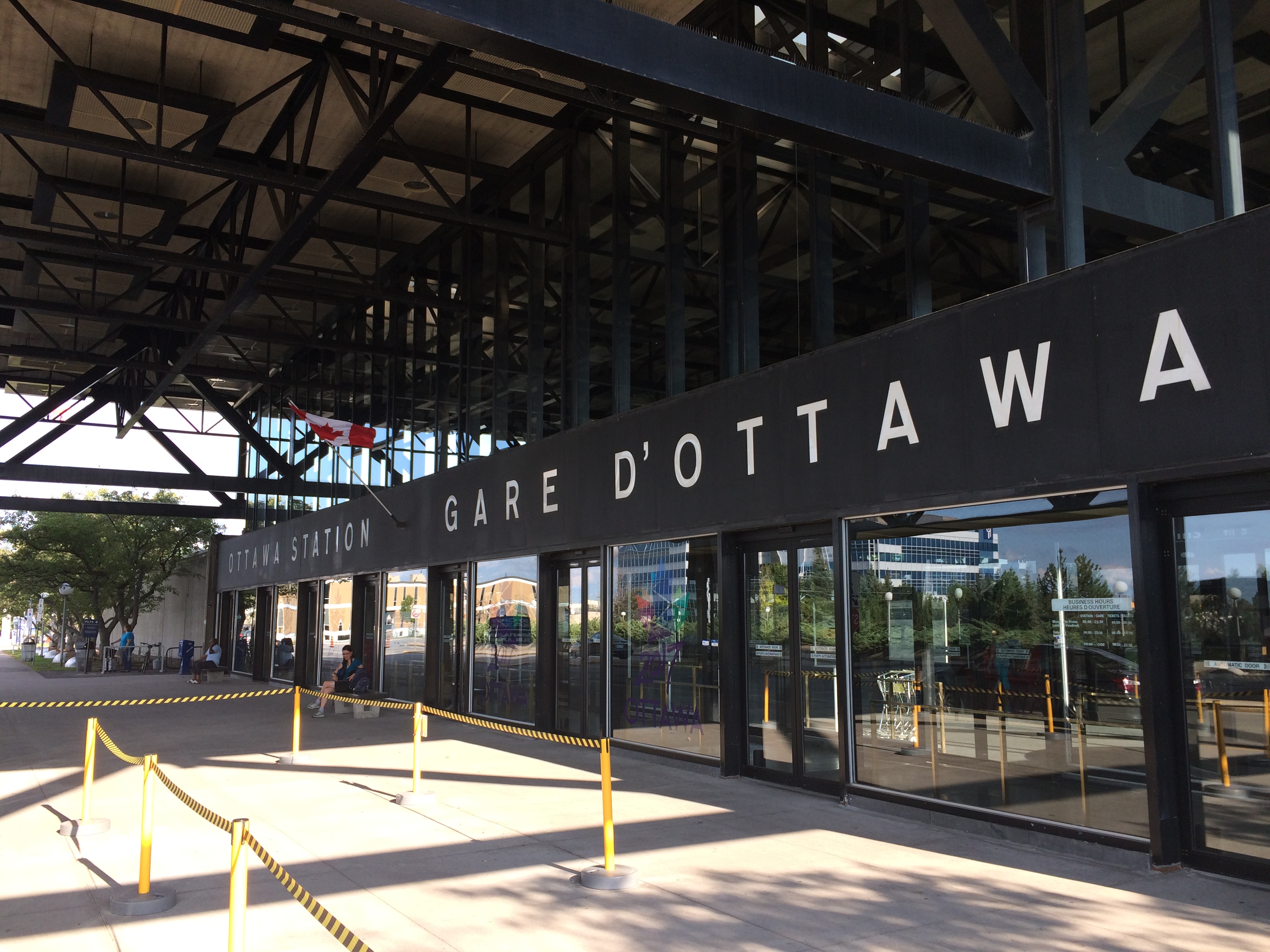
Fortunately, the passenger station was relocated to a point much closer to the city centre than the Gréber Plan envisioned: the old CN and CP tracks along the Rideau River south of the city centre were kept in place but rerouted to serve a new modernist station that opened in July 1966. The new Ottawa Station, designed by John C. Parkin, is one-of-kind. The architecture invokes an airport terminal, with large, sheltered driveways and an airy open lobby/concourse, and was the last grand railway station built in North America. In 1966-1967, there were still two daily transcontinental trains departing from Ottawa Station, along with multiple trains to Toronto and Montreal, including a Toronto-Ottawa night train. Today, there are just eight trains to Toronto and five trains to Montréal.
Ottawa Station, which opened July 31, 1966
Soon after the new station opened, the tracks and ancillary buildings around Union Station were removed, making way for Colonel By Drive, the Rideau Centre shopping mall, a new convention centre, and headquarters for the Department of Defense. The station building itself survived, however, first becoming a temporary museum space during the 1967 Centennial celebrations, then a government conference centre, mostly closed off to the public.
The temporary Senate Chambers in the former train concourse at Ottawa Union Station
Right now, the grand building is the temporary home of Canada’s Senate, and is again accessible to the public, via a free tour. The renovations to the building are very sympathetic to the built heritage. As reconstruction of Centre Block, the regular home of both Houses of Parliament, is still five years away from completion, there’s still lots of time to take the tour.
Awaiting Alto
The Alto high speed rail line project, now in the planning stage, will connect Québec, Montréal, Ottawa, and Toronto, with a total of seven stations (the other three are planned in Trois-Rivières, Laval, and Peterborough). The first segment, with the start of construction set for 2029, will link Montréal, Laval, and Ottawa. Consultations on the specific route and station locations are underway, with the broad corridors noted in maps available on the Alto website.
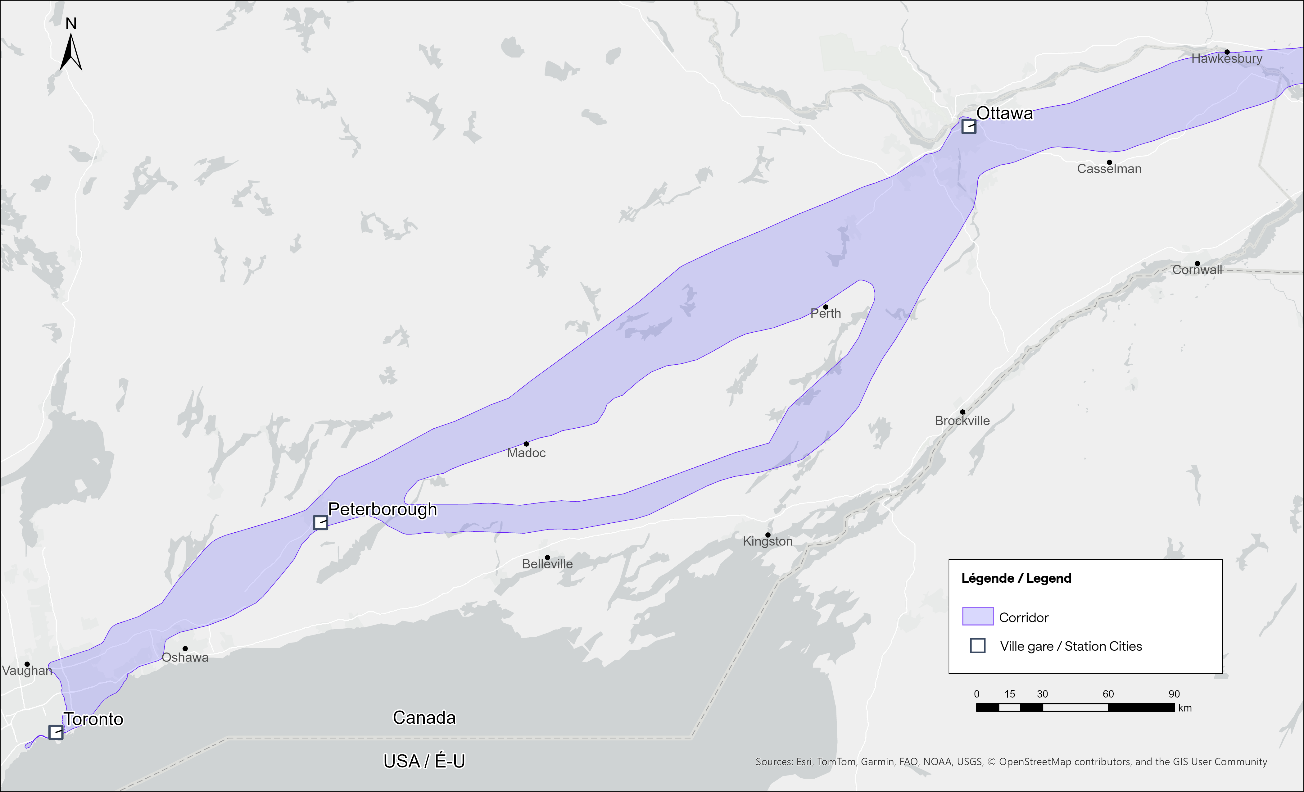
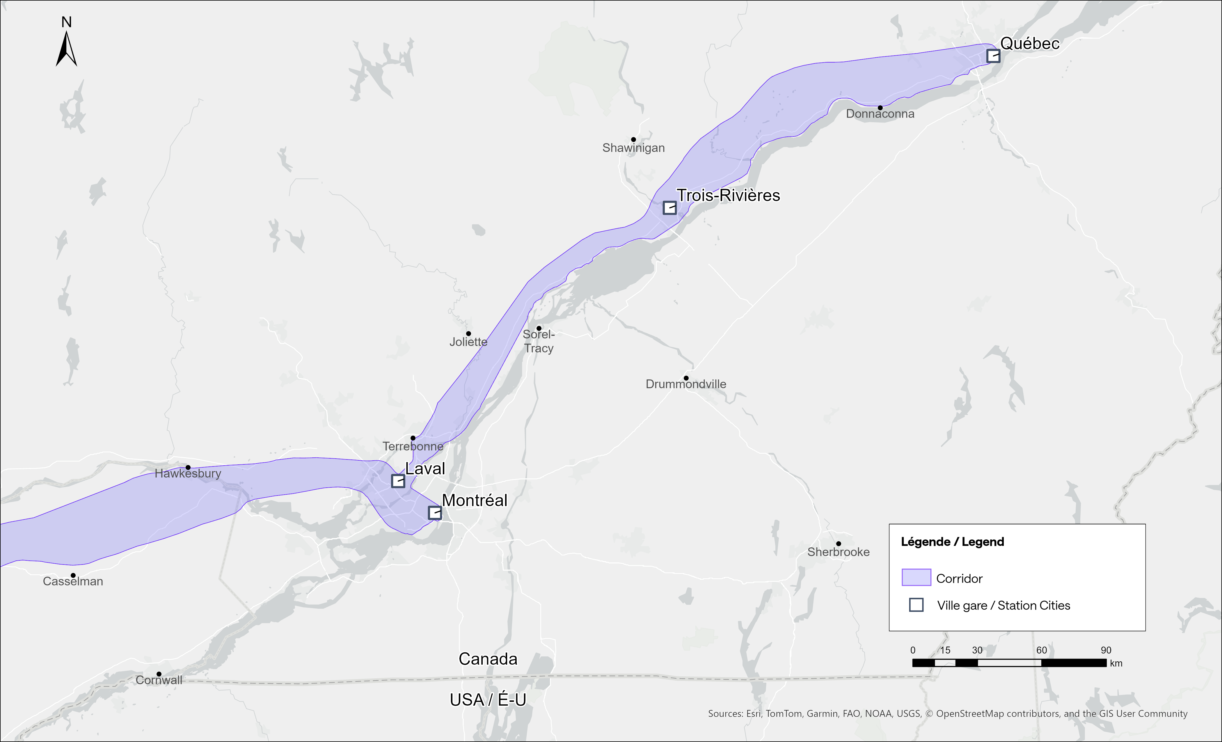
Map of potential routings for the Alto high speed line in OntarioMap of the planned routing for the Alto high speed line in Quebec
The maps clearly show a route between Ottawa and Montréal that will pass through Prescott & Russell Counties, roughly following an abandoned CPR corridor until about Hawkesbury, at which point it would cross into Quebec (following an older abandoned CNoR route) to Laval, then continue south into central Montréal, though not necessarily the existing Central Station (this would likely require a new tunnel under Mount Royal). The Montréal station appears to be a terminal for trains coming from Ottawa and from Trois-Rivières and Québec, much like the existing VIA Central Station.
Alto’s next phase towards Toronto could follow one of two broad routes between Ottawa and Peterborough, either just north of Highway 7, through the Canadian Shield, or a southerly alignment through the Rideau Lakes region and then through South Frontenac and passing near Stirling and Campbellford. All planned routes would require passing through Ottawa entirely on the Ontario side of the Ottawa River, making a through station particularly likely, especially for the critical Toronto-Montréal market.
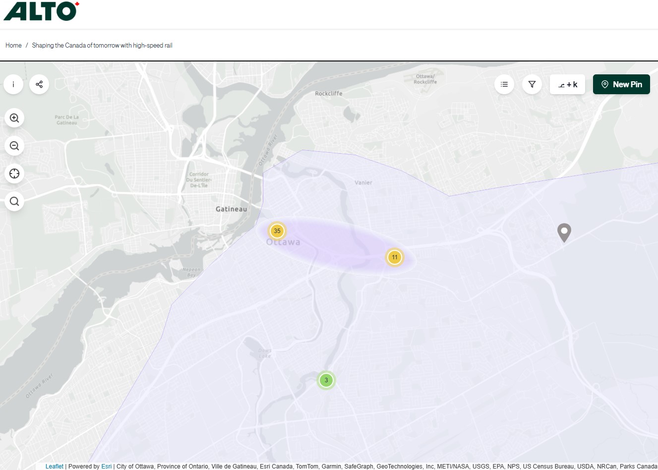
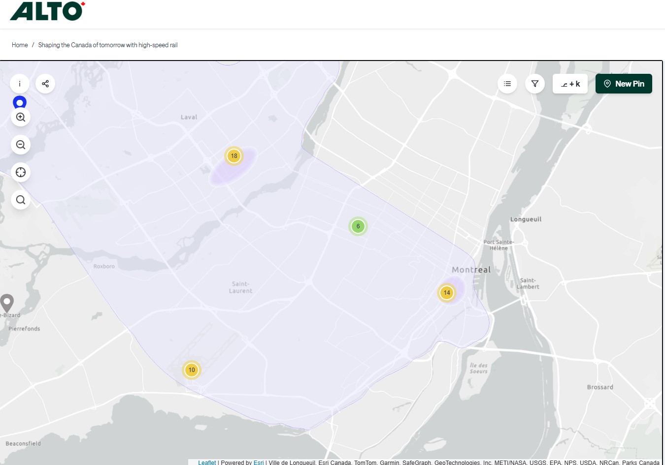
On the detailed consultation map, highlighted areas show where the seven station locations are being considered.
The map for Ottawa shows possible station locations in an area including the current VIA station and the old Union StationThe Montréaland Laval station locations under consideration. The Montréal station area highlighted includes the locations of Central and Lucien L’Allier Stations.The Montréal station for Alto is clearly intended to be a terminal.
The idea of a downtown Ottawa Station for the new high speed rail corridor is certainly enticing. It would breathe new life into a 114-year-old landmark, provide a very convenient spot for Ottawa politicians, public servants, business travelers, tourists, and students attending nearby University of Ottawa. Rideau O-Train Station is less than two blocks away. However, it would require a new tunnel and/or elevated structure to reach the station from the rail corridors to the south. Furthermore, Centre Block would have to reopen on schedule so the Senate can move back before construction can start on refurbishing the station for passenger service.
The 1966 Ottawa VIA Station, on the other hand, has its own advantages. There is plenty of room to build new high speed train platforms, which should provide level boarding for efficient passenger movement. There is also room for parking, passenger pick-up and drop-off, as well as easy access to the highway, unlike Union Station. With the closure of the Ottawa bus station, the VIA Rail Station has become a multimodal hub, with Ontario Northland, Flixbus, and Orleans Express all using the station’s driveway, along with a KLM/Air France shuttle to Dorval Airport. There is also a dedicated O-Train LRT station on-site, though it could be better integrated with the station building.
Perhaps most importantly, the existing VIA station can help ensure the existing Corridor service remains integral, as passengers from Kingston, Belleville, and elsewhere on Lake Ontario and the St. Lawrence River will not be served by Alto; neither would Casselman, Alexandria and Dorval. That the station is a through-line, and not a stub-end terminal, will also ensure that the crucial Toronto-Montréal market will see minimal delays from back-tracking and reversing at a downtown terminal. Though there are instances of high-speed trains reversing directions at major hubs — Trenitalia’s Frecciarossa mainline between Milan and Salerno turns back at Roma Termini and at Napoli Centrale — this is an uncommon arrangement.
All the planned Alto high speed rail stations will have to be easily accessible and close to the downtown cores of the cities it serves. At this point in the planning process, this looks like it will be the case at all three big city stations. But it will need more than walk-up traffic like downtown office workers and tourists; it will be most successful as part of a complete network of local, regional and intercity transport, including the conventional VIA rail system. With specific improvements, including new platforms and better O-Train station integration, the modern yet historic 1966 Ottawa Station is well suited for all of these needs.
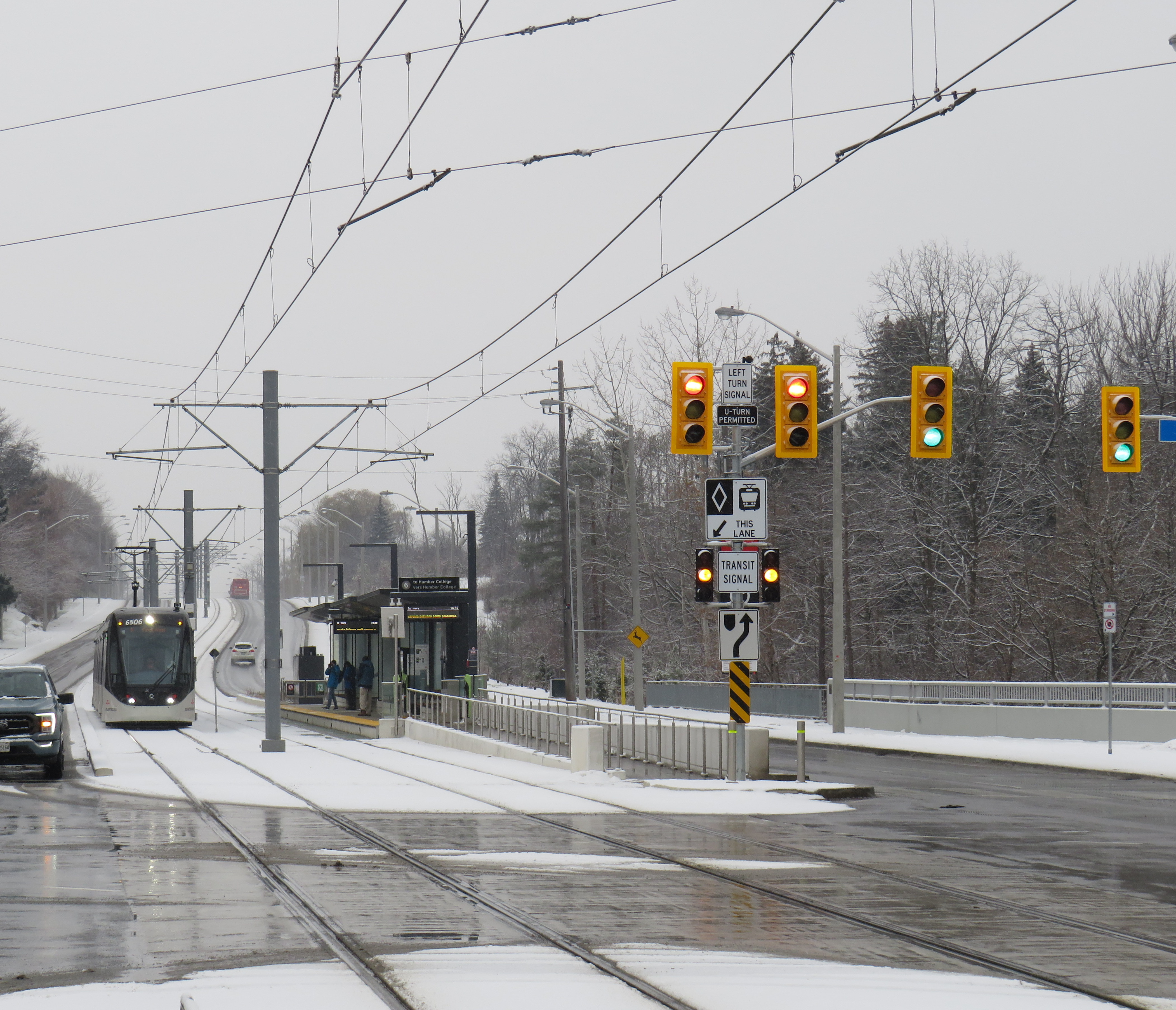
There is a light rail system in Ontario that works in the snow. ION LRT at University of Waterloo.
Less than a two hours drive or train ride from Toronto, where that city’s first light rail line opened to universal disdain, a light rail line has been operating without incident for over five years. Trains operate like clockwork, signal priority works, and it has become the backbone of a regional transit system.
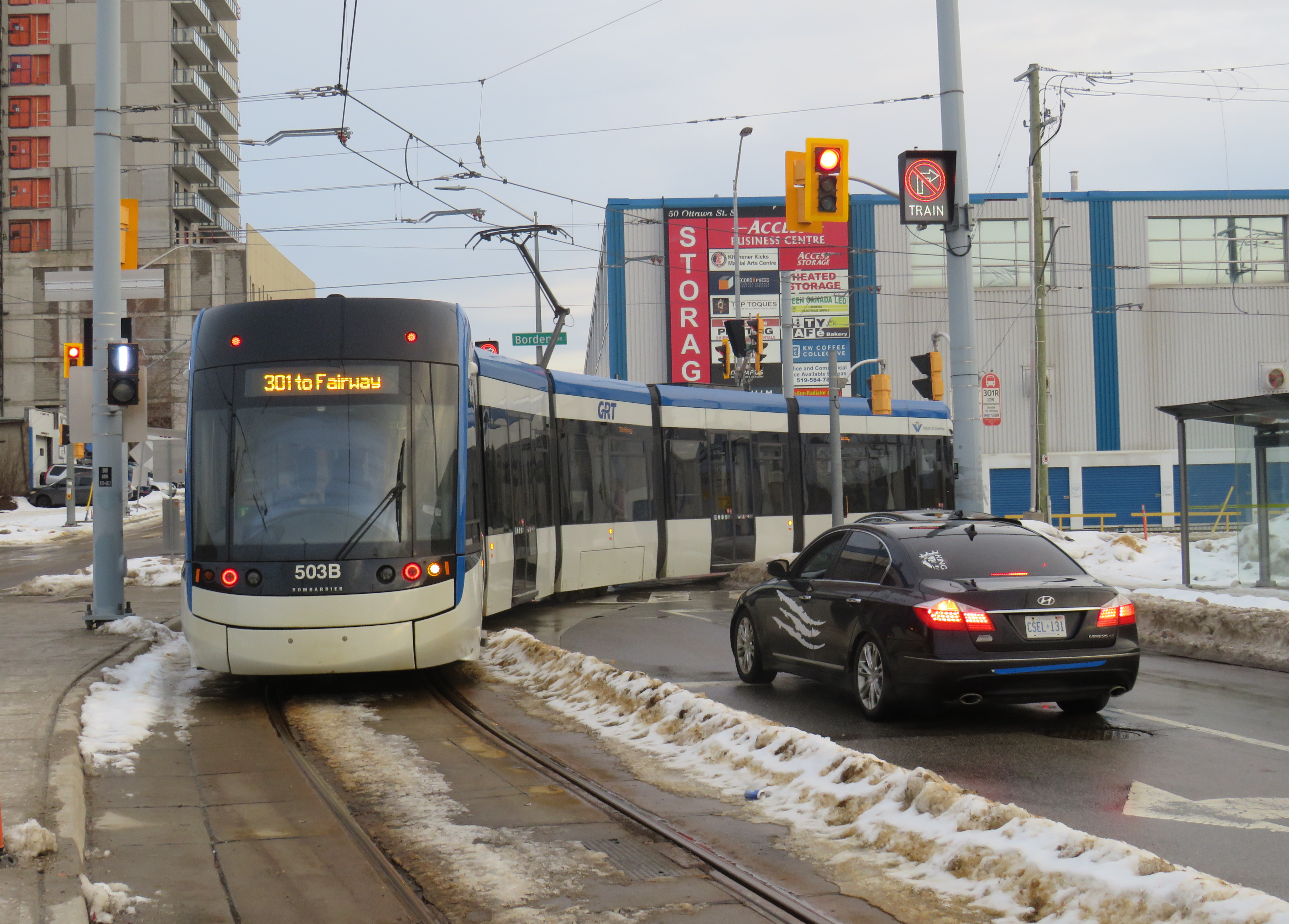
A southbound Ion LRV turns from Charles Street to Borden Avenue. Note the white bar signal and the “no right turn – train” sign lit up.
Funded by all three levels of government, the Ion LRT was constructed and operated by GrandLinq, a public-private partnership (P3) consortium that includes operator Keolis and engineering and construction firms such as Aecon, Kiewit, and Plenary Group. Though design-build-operate P3 models are common for Canadian transit infrastructure projects, they have their challenges, as Waterloo Region would later find out. Fares and service are integrated into the Grand River Transit bus system, which is owned and operated by the regional government.
Waterloo Region is the smallest urban region in North America with a light rail system, and it works largely because of Kitchener-Waterloo’s geography. Many important regional destinations line up along the corridor: the terminals are both major suburban shopping centres that already functioned as major bus transfer points. In between the two malls are Downtown Kitchener and Uptown Waterloo, the two historic town centres, University of Waterloo, Wilfrid Laurier University, and Kitchener-Waterloo Hospital. The LRT serves or passes near all these destinations (though Laurier’s campus is centred a few blocks east of the LRT corridor). Furthermore, the region’s master plan focuses urban growth along the LRT corridor with new high-rise residential and mixed-use development. A planned extension of the LRT into Cambridge south to the historic Galt town centre will further support regional urban intensification goals.
Ion trains operate every 10 minutes during weekday daytime hours; they operate every 15 minutes on weekends and weekday evenings, with 30-minute service from about 10:30 PM to the end of service starting around midnight.
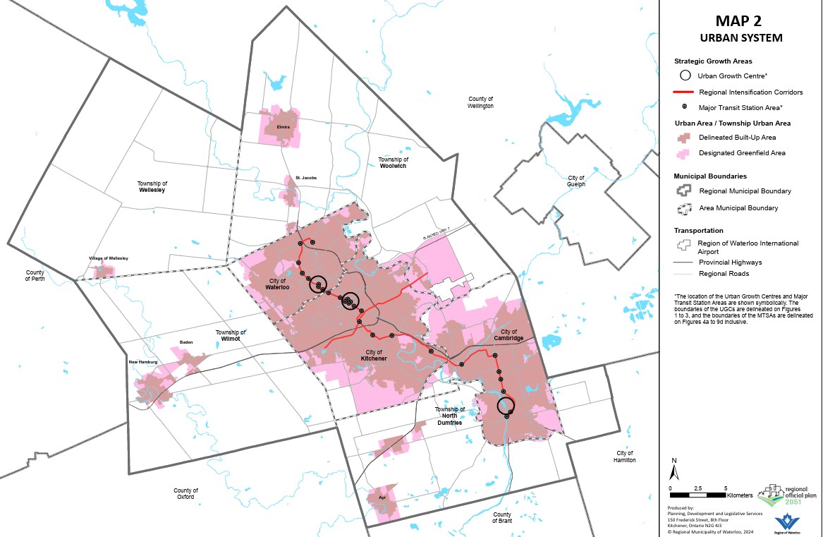
Map of Waterloo Region’s urban system, which directs growth to existing and planned transit corridors and limits growth outside the cities of Kitchener, Waterloo, and Cambridge.From the regional official plan.
Despite following a linear corridor, the LRT winds its way along city streets, railway rights-of-way, and hydro corridors. This allowed the region to reduce property and road construction costs as well as achieve higher speeds in specific off-road sections. The fastest section is north of Uptown Waterloo, where the corridor makes use of a freight railway spur line between Kitchener and Elmira that also happens to run directly past University of Waterloo. In the south end, a different railway corridor and a hydro corridor allow trains to reach Fairview Park Mall on a mostly off-street alignment. These off-road segments are protected by railway signals and barriers, like those in along LRT lines in Calgary and Edmonton.
This ability to switch between different alignment types is a clear advantage of light rail transit for medium-capacity transit systems. During overnight hours, freight trains headed to a plastics plant in Elmira use the same rails north of Uptown Waterloo as the LRT does during the day, making it an example of the “tram-train” model more common in Europe.
The on-street sections, though slower than the off-road portions, provide access to Downtown Kitchener and Uptown Waterloo, including the planned new transit hub in Downtown Kitchener that will provide a better connection to GO Transit trains to Toronto. Unlike Toronto’s streetcars and Finch West LRT, however, the signal priority system works. On King Street between Downtown and Uptown, there are many intersections with traffic signals, but the LRTs generally do not have to stop at any of those red lights. At intersections, LRVs continue at regular speed, typically 40 km/h through this section.
A southbound LRV on King Street. It just passed two signals with a clear (white vertical bar) signal; the next signal ahead will soon change to allow the LRV to proceed. Note that there are no “transit signal” signs, as Waterloo Region worked to have these approved by the province.
Waterloo Region also worked to permit unique transit signals, which feature only white bar aspects. A vertical bar indicates “proceed” while a horizonal bar indicates “stop.” A flashing horizontal bar lets the operator know that it will soon switch to “proceed” while a flashing vertical bar warns of an upcoming stop signal. This reduces the sign clutter that is found on Toronto’s streetcar and light rail corridors.
A typical Toronto assembly, with red, amber, and green transit signal aspects that look similar to the larger traffic lights above and accompanied with a “transit signal” sign. Of course, the Finch West LRV approached an amber signal, rather than being given a go ahead.
To be fair, the advantage in Waterloo Region is that most of the on-street sections of the LRV corridor are on narrower urban streets rather than suburban arterials like Finch Avenue. King Street and Charles Street in Kitchener only have two general traffic lanes and are not major throughfares (a provincially-maintained freeway between St. Jacobs, Waterloo, Kitchener, and Highway 401 absorbs much of this traffic). The regional government also widened a section of Weber Street to four lanes to divert traffic from King ahead of LRT construction. This resulted in the loss of about two dozen houses and businesses.
But by maintaining a narrow right-of-way on King Street, the LRT runs with minimal delays. It is easier to provide aggressive transit signal priority with short pedestrian crossing distances, narrow intersections, and lower traffic volumes.
The video below illustrates how the LRT runs along King Street northbound from Kitchener Central Station.
View from the front of a train heading north towards Waterloo
Despite the LRT working well, it is still far from perfect: there are several sections in which the trams crawl at a 10 or 15 km/h speed, particularly on the south end. At Hayward Avenue the route switches from a railway corridor to an alignment alongside Courtland Avenue; this section has two tight turns and crosses an industrial driveway. Had a few more properties been expropriated (at additional cost) this would not have been an issue. Until a proper protected pedestrian crossing is installed at a path connecting Trayner Avenue to Fairway Road (a critical pedestrian link that was overlooked during the planning phase), LRVs must also slow down along the hydro corridor approaching Fairview Park Mall.
The P3 contract also limits the ability to make service improvements. In 2024, Waterloo Region proposed revising the LRT schedule to run trains every eight minutes during peak periods, but because of a fixed staffing contract, it would have resulted in 30-minute service after 8PM. Luckily, local transit advocates successfully opposed that change. Had the LRT been operated directly by Grand River Transit, they could have simply trained more operators on the LRT service, even transferring bus drivers to the rail division.
Overall, however, the LRT works in Waterloo Region both as a transit service and a planning tool. It provides useful lessons on what to do (real signal priority and proper signal aspects, make effective use of on-street and off-street routing where each makes sense), and what not to do (enter strict operating contracts) when building a new transit line. Waterloo Region made its rail transit work for its geography and its needs, and that is the most important thing.
December 7, 2025 may be a day that will live in transit infamy. That was the day Line 6, the Finch West LRT, opened to the public, and it did not go well.
First off, any discussion on the initial failure of Line 6 should acknowledge that was never designed to be a rapid, regional transit link. The LRT, serving Northwestern Toronto, was intended to be an upgrade to the slow, congested, and busy 36 Finch West bus, feeding into the rapid transit network at Finch West Station. Line 6 is a legacy of Transit City, a LRT plan proposed under previous mayor David Miller intended to connect the inner suburbs of Etobicoke, North York, and Scarbrorough to the subway and to each other.
As with all proposed Transit City routes (with the exception of the tunneled central section of the Eglinton-Crosstown LRT), there were always going to be compromises on Finch that would not make it a true rapid transit service. Situated almost entirely on the surface, Line 6 trains are easier for residents to access than subways in deep tunnels; closer stop spacing was intended so the new transit line continues to serve the needs of those who live, work, go to school, and frequent the corridor, without the necessity of a parallel local bus. Anyone expecting subway speeds were in for disappointment.
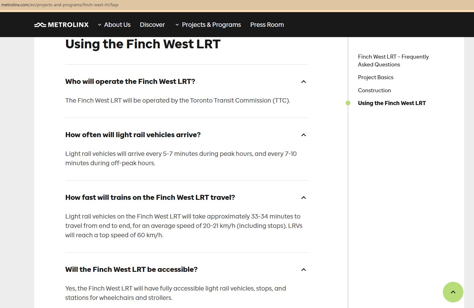
Still, the LRT was supposed to improve travel times over the existing bus, with wider stop spacing than the legacy streetcar network, a congestion-free right of way, signal priority, and decent operating speeds. With a promised average speed of 20-21 kilometres per hour, a total trip time of 33-34 minutes each way, it would have been a bit faster, more comfortable, and certainly more reliable than the bus. It was never going to be as fast as a subway, but for Finch Avenue West, that was okay.
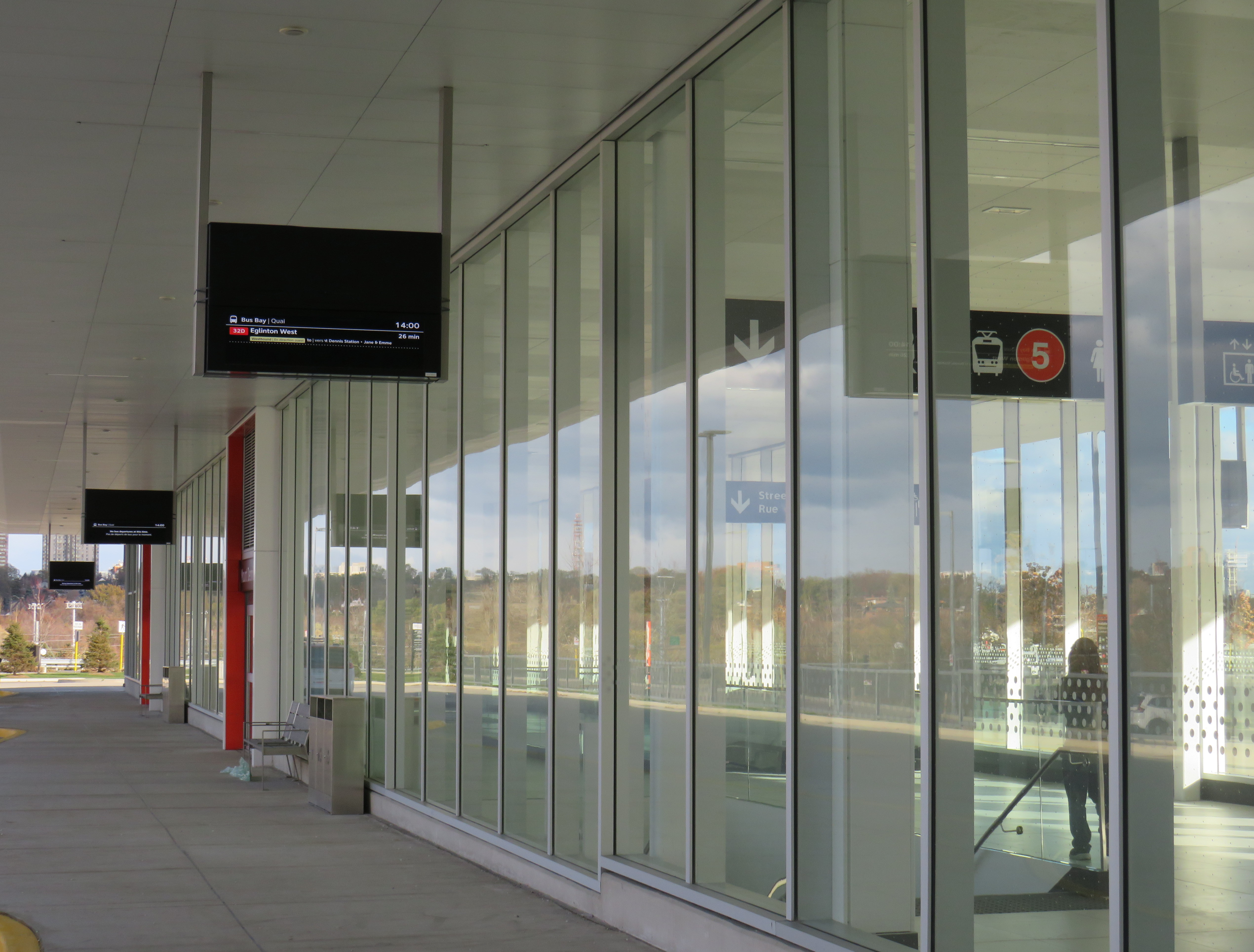
Screen capture of a Metrolinx FAQ webpage, with frequent and relatively speedy transit service promised for the Finch West LRT. The webpage was still up as of December 18, 2025.
As the first modern LRT to open in the Greater Toronto and Hamilton Area (GTHA), Line 6 was to be a preview of additional lines planned and under construction elsewhere in the Golden Horseshoe, including the yet-to-open Line 5 Crosstown LRT, the Hurontario Line, the Hamilton LRT, and a proposed Line 7 on Eglinton Avenue East towards the University of Toronto Scarborough Campus and Malvern. Delivered by Metrolinx, the provincial transit agency, each line would be constructed and maintained by a P3 consortium, though the Toronto LRTs would be operated by TTC employees.
The hoped-for narrative that the provincial government, Metrolinx, the city of Toronto, and the TTC all touted — a smooth new ride, worthy of including on the subway maps — quickly fell apart on Sunday December 7, though there were plenty of warning signs of slower-than-promised operations.
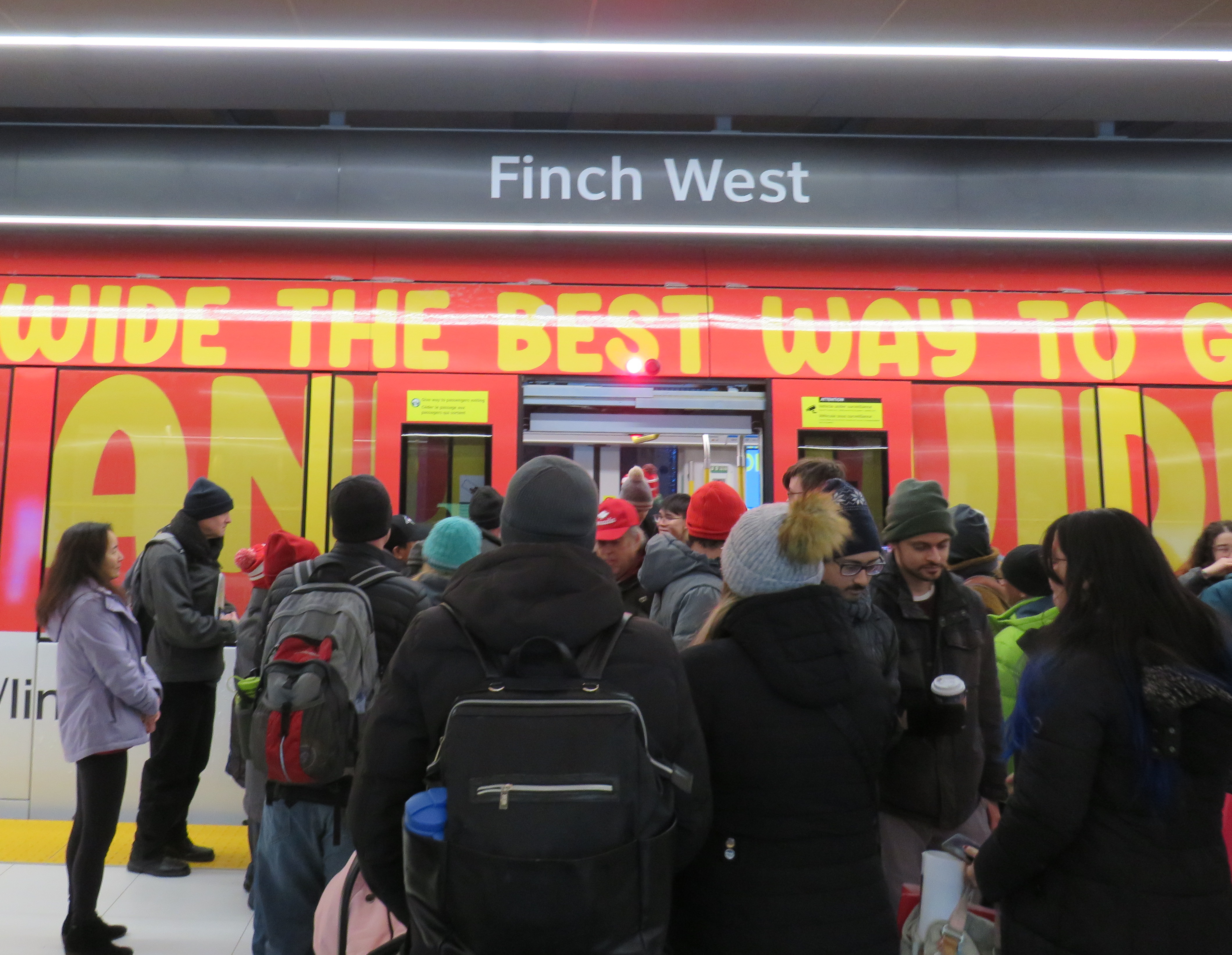
Opening day crowds on December 7. Passengers disembark from a wrapped LRV that touts Line 6 as “far and wide the best way to go far and wide.”
On Sunday, December 7, there were plenty of people eager to try the new LRT: railfans and urbanists, curious families, and local residents, lured by free fares on the opening day. Though I was there and took several trips, I wasn’t going to make too many judgements on opening day. There would be inevitable hiccups with the large crowds and cold, snowy temperatures. Still, there were visible problems.
An eastbound LRV approaches Islington Avenue (Mount Olive Station) as the transit signal switches from green to amber. The traffic signals are still green.
So far, a lot of the post-opening discourse has been on operating speeds and traffic operations. Instead of 33-34 minutes, as claimed by Metrolinx, trips were taking 55 minutes each way. Additionally, the transit signal priority (TSP) system has not been activated, causing light rail vehicles (LRVs) to wait entire light cycles, even for private vehicles to turn left before proceeding. The dedicated transit signals turn red about 10-20 seconds before general traffic gets a red light, even as LRVs approach the intersections. On December 16, Toronto City Council approved a motion to implement “more aggressive” TSP on Finch West and the surface portion of the Line 5 Eglinton-Crosstown LRT, as well as on the legacy streetcar network.
The problem on Finch West is not just a matter of transit signal priority. The number of stops along the line, also criticized by several critics, is also not a problem, as Finch West was never intended to be a high-speed regional line. (That said, Mount Olive and nearby Stevenson could have been consolidated into a single stop west of Kipling Avenue.) The other problems are poorly managed schedules and streetcar-style slow zones on a modern LRT alignment.
Right now, LRVs are forced to slow to 25 km/h at all intersections, even though all conflicting traffic has a red light. This is an inexplicable restriction given that motor traffic, including TTC buses, have a 50 km/h limit, and many drivers will proceed at significantly above the posted limit. These restrictions are not found elsewhere in North America; in Calgary and Edmonton, LRTs are protected at many at-grade intersections with railway-style lights and gates. In places like Minneapolis-St. Paul and Phoenix, additional LED flashing signs warn drivers of an approaching LRV, which glides through the signalized intersection at higher speeds than on Finch. (There is also a lot less sign clutter, with intuitive signals for left turns and transit).
Transit schedules are also needlessly padded, with too much time for lower speeds and lengthy station stops. On a repeat visit to Finch West, on Wednesday December 17, 2025, travel times were inconsistent and slower then either 36C bus I took a few days before the LRT opened. (Even the trip with the long Starbucks pitstop.)
Line 6 travel times on Wednesday Dec. 17
Eastbound (read down)
Stop/station
Westbound (read up)
12:59 PM (dep.)
Humber College LRT Station
12:31 PM (arr.)
1:03
Westmore Dr.
12:25
1:05
Martin Grove Rd.
12:22
1:10
Kipling Ave. (Mt. Olive)
12:13
1:14
Islington Ave. (Rowntree Mills)
12:09
1:26
Weston Rd. (Emery)
11:57
1:29
Arrow Rd./Signet Dr.
11:54
1:33
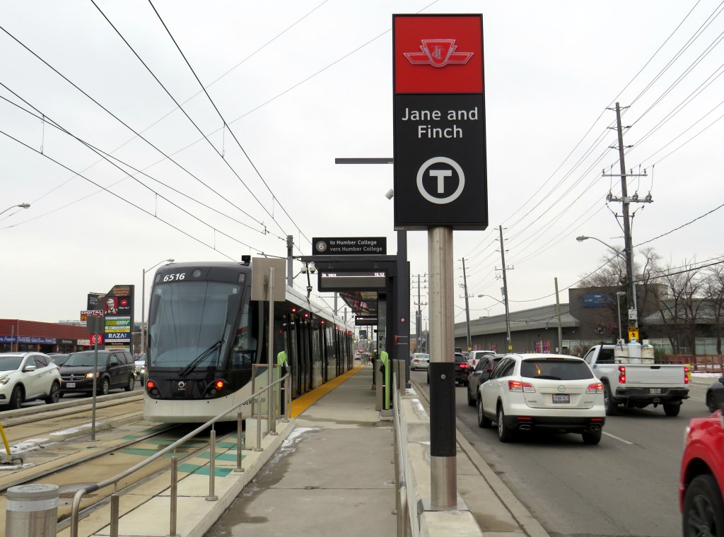
Jane and Finch
11:46
1:37
Tobermory Dr.
11:35
1:45
Sentinel Rd.
11:32
1:48 PM (arr.)
Finch West Stn. (LRT Terminal)
11:27 AM (dep.)
49 minutes
Total time
1 h 4 minutes
It took eleven minutes to go two stops, less than a kilometre, from Tobermory Drive to Jane Street on the westbound trip. Lengthy station dwell times at Tobermory (five minutes) and Mount Olive (three minutes) on that westbound ride, with no onboard announcements was especially frustrating. The return eastbound trip from Humber College was 15 minutes faster, even with much of the same slow zones at intersections and switches, the 10 km/h curve near Humber College Station, and lengthy stops.
With such unpredictable and unreliable service, Line 6 is running at least as badly as the downtown streetcar routes. Without immediate fixes, people will completely lose faith in the TTC and future LRTs, including Eglinton-Crosstown. We can not just rely on tweaks to signal times; we need a complete review and overhaul of streetcar and LRT operating practices.
At least we know what can and should be fixed before the Eglinton-Crosstown line opens, a much longer LRT route that will have a regional transit role.
One more thing…
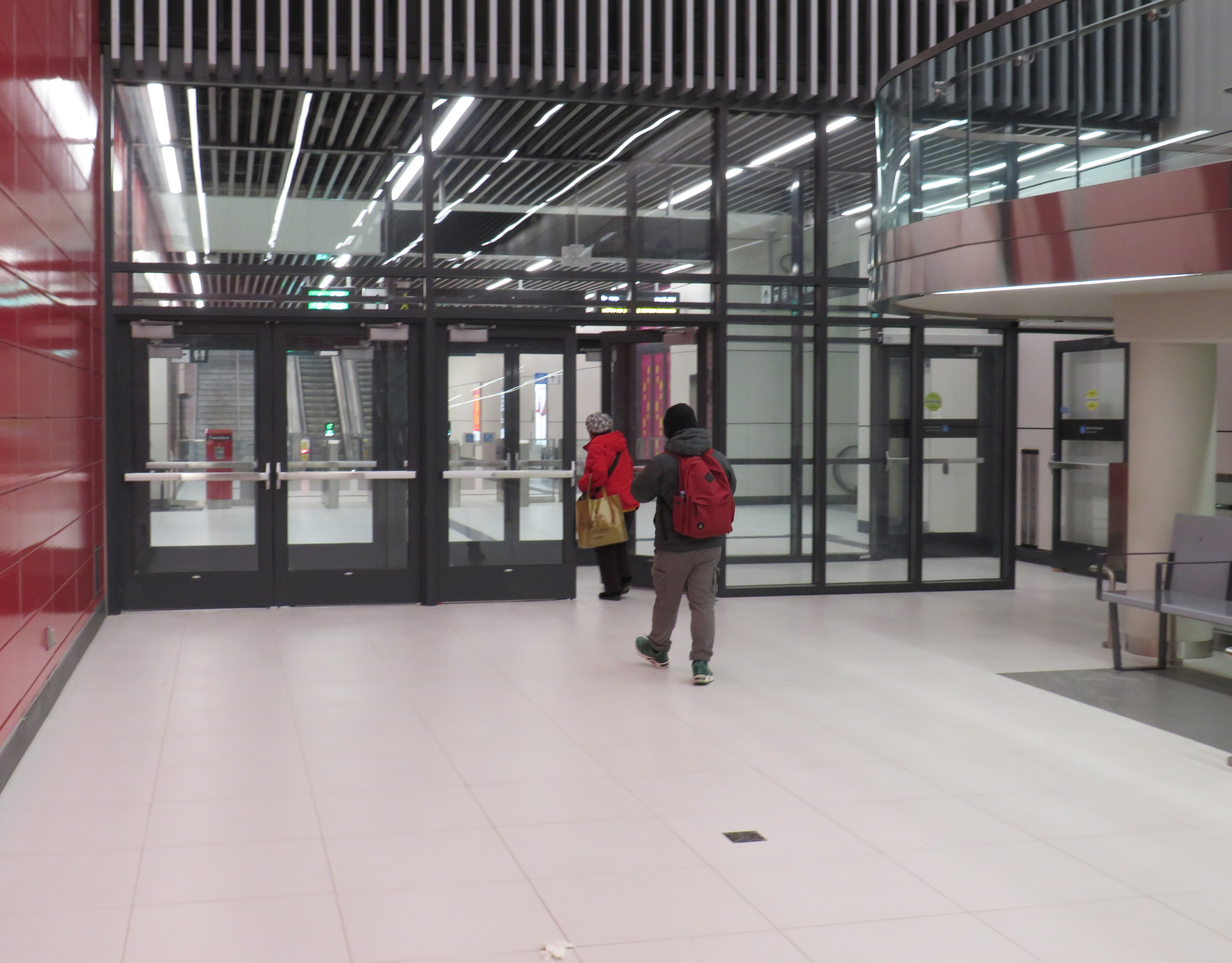
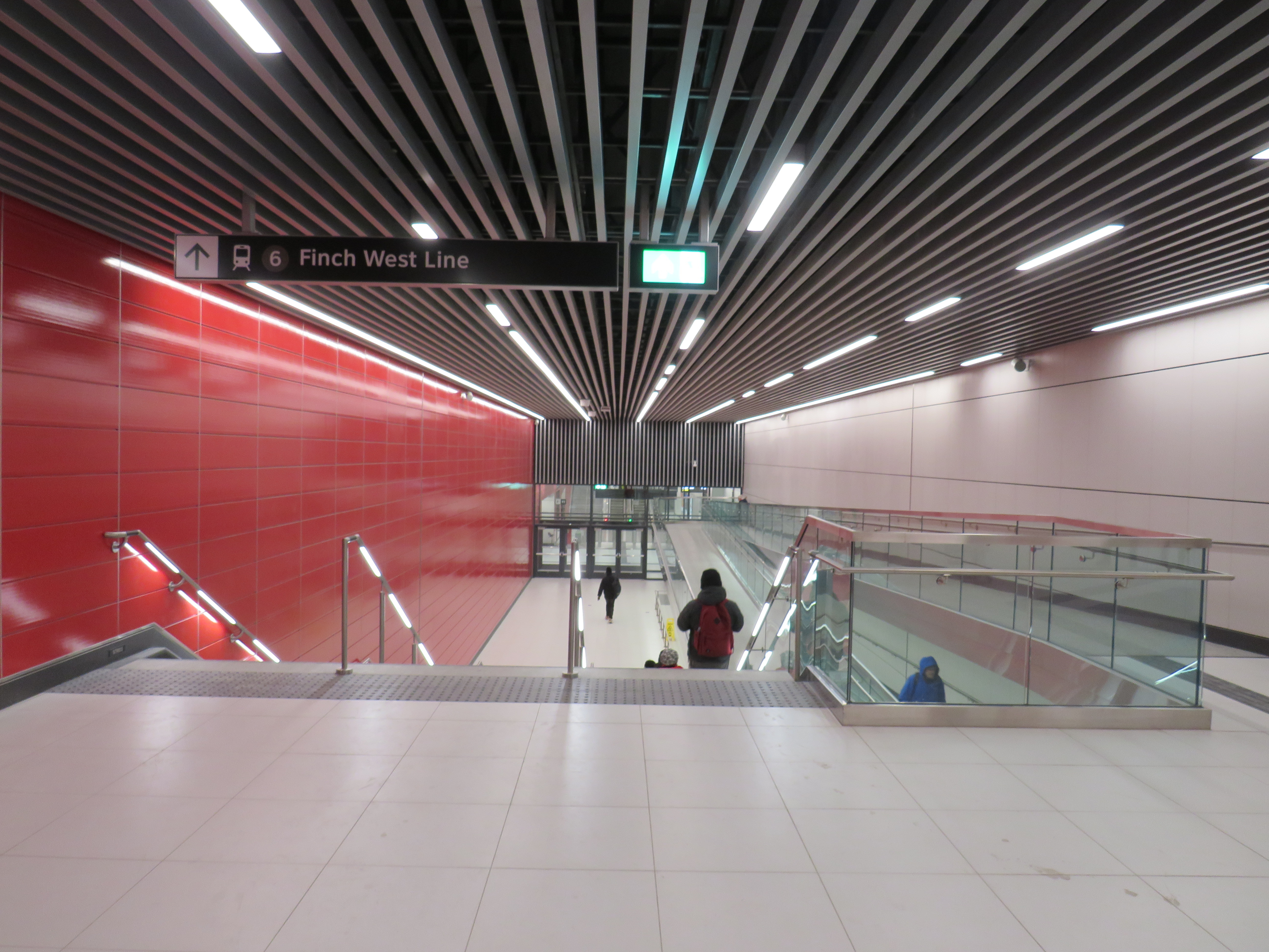
What is with all the doors between the Line 1 subway station and the LRT terminal at Finch West. Passengers have to pass through four sets of doors to transfer between two TTC services, as well as ascend one escalator or elevator, walk down one set of stairs (or navigate a long and circuitous ramp) and then ascend another escalator or elevator to get to the other platform.
Stairs or a long, circuitous ramp between the doors from subway to LRT
Though transfers can be tricky, at the very least, these doorways should be kept open, and shut only during station closures or during fire alarms, as done in hospitals or shopping centres. Other TTC stations have no such barriers between modes or may have a single door to exit a subway station terminal to the bus platform. Automatic sliding doors could have also been an option. Instead, the powered doors are left to one side, with the button against the wall. It’s not an ideal design from an accessibility point of view.
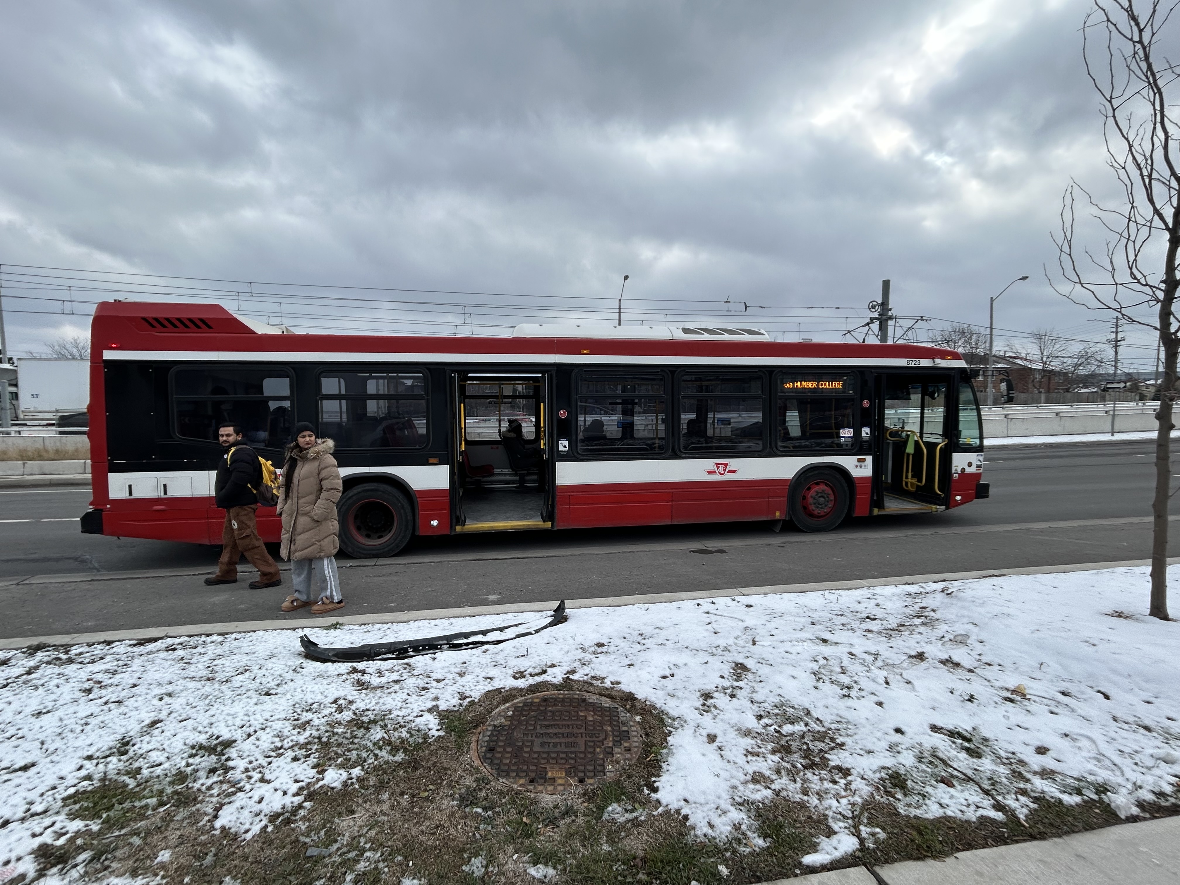
Two Line 6 LRVs cross Jane Street at Finch Avenue, December 3, 2025 as training wraps up ahead of revenue service on December 7
Can a brand-new light rail line outrun the local bus it replaces? Starting on Sunday, December 7, Torontonians will get the chance to find out when the new Line 6 Finch West light rail line finally opens to the public. Though built and maintained by Metrolinx, the service will be operated by TTC employees.
The new LRT, 11 kilometres long, with 18 stops, runs almost exclusively in a transit-only median on Finch Avenue West between Finch West Station at Keele Street in North York and Highway 27 in Etobicoke. The end terminals are below grade, with three traffic signals skipped. Otherwise, the light rail vehicles will be subject to stopping at the same traffic lights as all other cars, trucks, and buses.
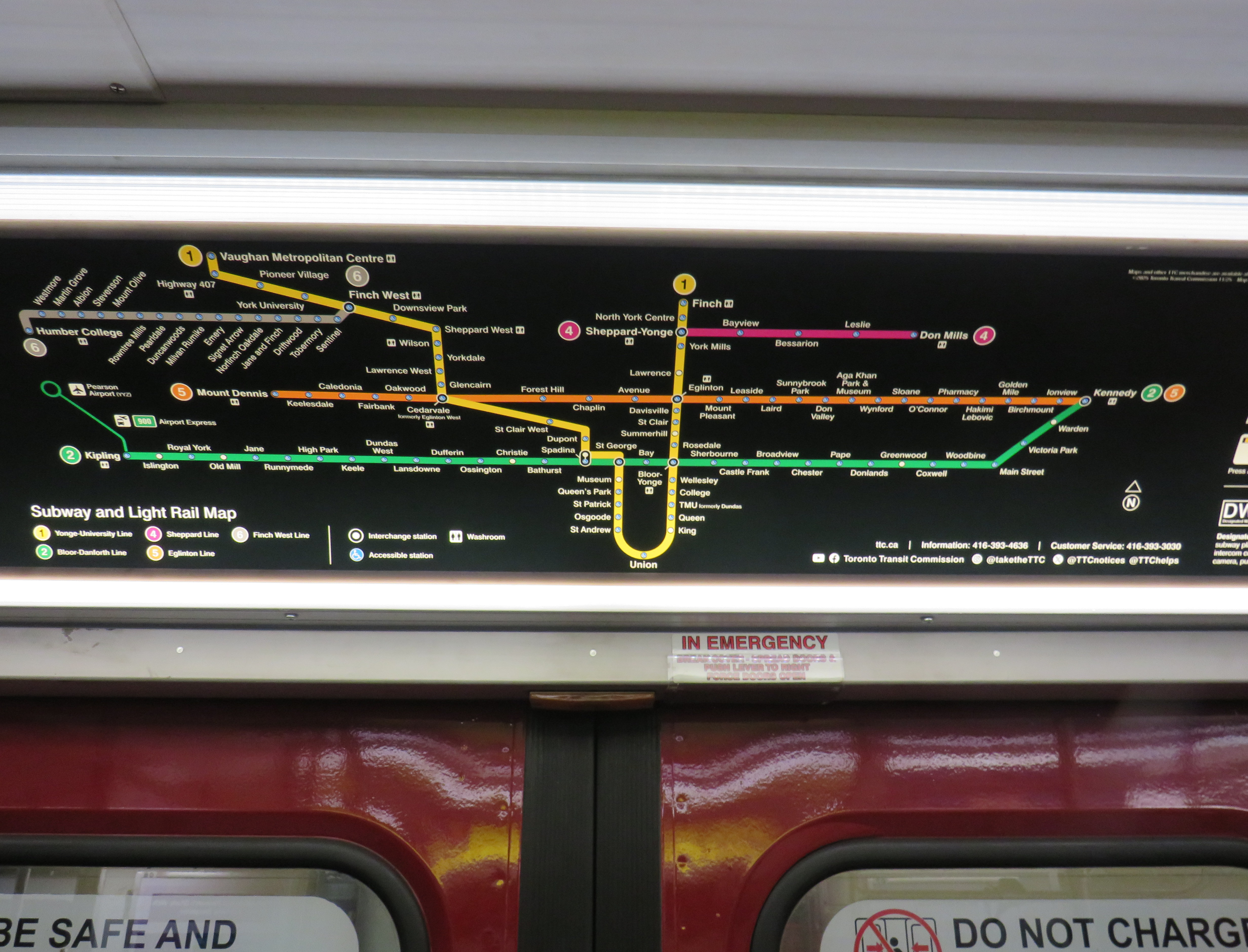
New maps in the TTC subway system show the long-delayed Line 5 Eglinton-Crosstown (opening date still TBD) and Line 6, which opens Sunday December 7
For the last few weeks, Finch West has been served by the 36C bus, running between Finch West Station at Keele Street and Humberwood Loop near the Mississauga border, making a stop at the Humber College bus terminal. A separate 36 Finch West bus continues east from Finch West Station to Finch Station at Yonge Street. There will only be eight fewer stops on Line 6 than there bus stops between Finch West Station and Humber College; apart from overnight service, there will be no parallel local bus serving the corridor.
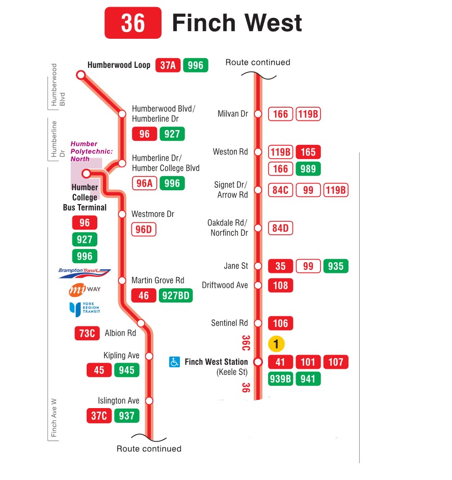
Map of the Route 36C Finch West-Humberwood service, modified from the TTC’s original
Without limited stops and signal priority, the new light rail line will not achieve any real time savings. On his website, transit advocate Steve Munro notes that the end-to-end time of the new Line 6 LRT is scheduled for 46 minutes, consistent across all operating time periods. The 36C’s fastest round trip times, late evenings and early Sunday mornings, is between 79 and 82 minutes, or 40-41 minutes one way on a slightly longer route.
To see this for myself, I visited Finch Avenue West and rode the 36C both ways between Finch West and Humber College. Wednesday, December 3 was an overcast and cold day, with the daytime high temperature hovering around the freezing mark. But the roads were clear and dry, with no collisions and little construction work in the way of traffic on Finch; conditions couldn’t be any better for early December.
Here were the times for the two buses I took. I started timing the runs as soon as the bus doors closed and departed the originating stop; waiting times at the initial stops were not included.
TTC Route 36C travel times on Wednesday Dec. 3
Eastbound (read down)
Stop/station
Westbound (read up)
12:07 PM (dep.)
Humber College bus loop
1:50 PM (arr.)
12:11
Westmore Dr.
1:37**
12:13
Martin Grove Rd.
1:24
12:18
Kipling Ave. (Mt. Olive)
1:29
12:20
Islington Ave. (Rowntree Mills)
1:19*
12:28
Weston Rd. (Emery)
1:11
12:33
Arrow Rd./Signet Dr.
1:09
12:38
Jane and Finch
1:04
12:42
Tobermory Dr.
1:01
12:44
Sentinel Rd.
1:00
12:51 PM (arr.)
Finch West Stn. (bus terminal)
12:57 PM (dep.)
44 minutes
Total time
53 minutes
* At Islington Avenue westbound, the bus was delayed by five minutes by a troublesome passenger ** At Westmore Drive westbound, the operator left the bus with twelve passengers on board to order coffee at a nearby Starbucks, resulting in a second delay of nearly ten minutes
The eastbound departure, leaving Humber College at 12:07 PM, made it to Finch West Station in 44 minutes, two minutes faster than the scheduled LRT trip. This bus, an articulated (18-metre) vehicle was relatively busy, with a few standees between Jane Street and Finch West Station, and most en route stops were made. There were no unusual delays; just some traffic near Highway 400; it also took two light cycles to complete the left turn from Finch to Keele approaching the subway station.
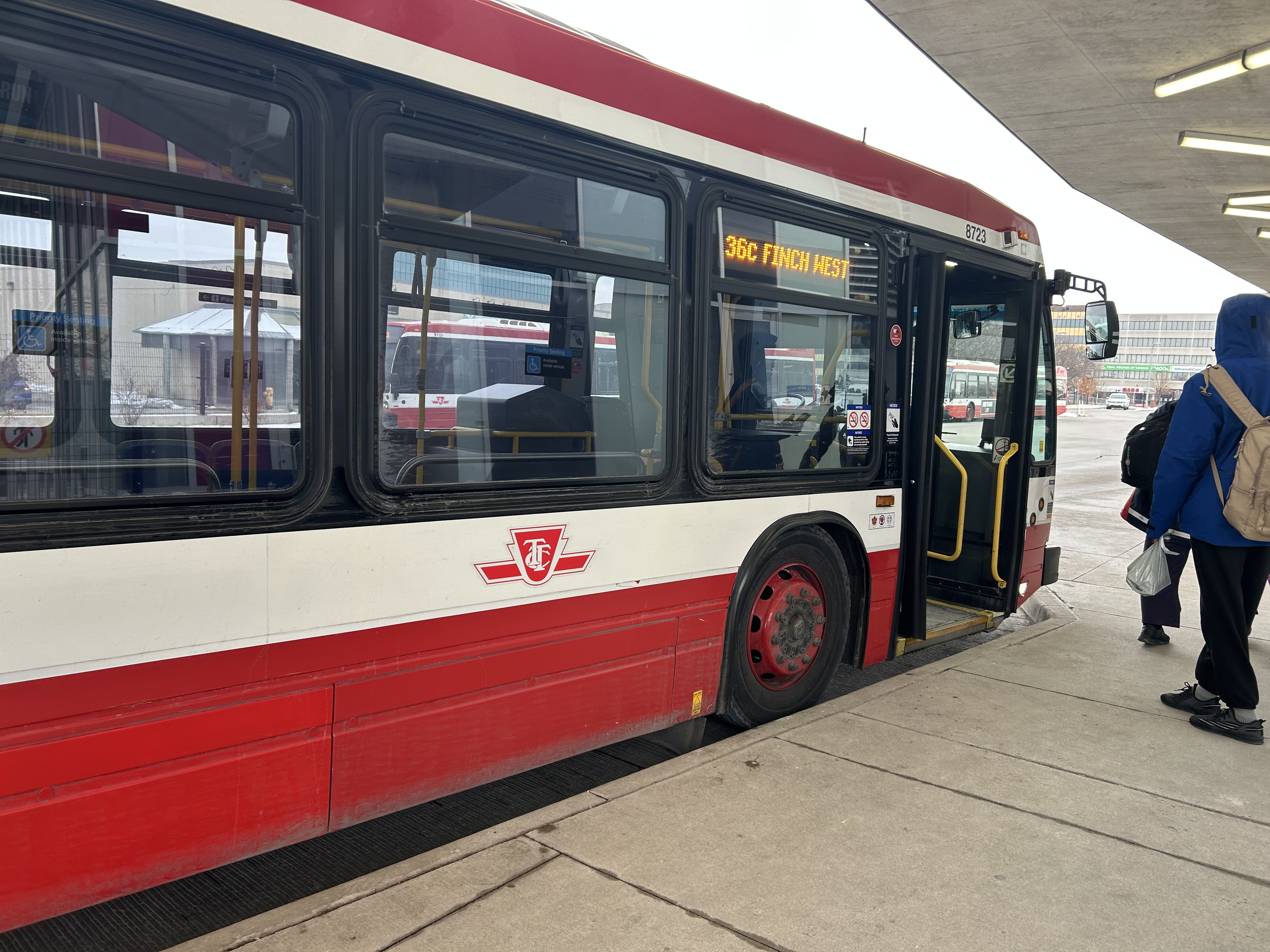
Westbound 36C bus waiting to depart Finch West Station
I returned towards Humber College on a different bus that left Finch West Station at 12:57 PM. For a while, this run, a standard 12-metre bus, was making exceptionally good time, with only a few passengers on board. It skipped several bus stops as no one wanted on or off until Tobermory Drive. Line 6 LRVs will stop at every station, just like the subway, even if there aren’t any waiting passengers.
At Islington Avenue there was a delay caused by a prospective passenger who rushed through a don’t walk/red light to get the bus, despite another one close behind. As the passenger was using a mobility device, the bus operator had trouble deploying the ramp because the bus had already inched ahead of the bus stop pad, ready to proceed with the green light. The driver needed to reposition the ramp and wait for the next green, which resulted in a five-minute delay.
Another delay came a few minutes later, when at Westmore Drive, just one stop before the Humber College bus terminal, the operator left the bus without notice and walked into a nearby Starbucks. After a few minutes, and seeing two other westbound 36C buses pass by, most passengers exited the open doors to flag down the next bus.
Passengers leave an unattended Route 36C bus on Finch Avenue West at Westmore Drive. The portal for Line 6 LRVs to descend under Highway 27 towards Humber College is behind
The TTC operator returned eight minutes later, and we finally arrived at Humber College Bus Terminal at 1:50, 53 minutes after departing Finch West Station. (It’s worth noting that Humber College also has a Starbucks and public washrooms in the main building near the bus loop.)
At least that’s one instance where the LRT will certainly be faster than taking the bus.
A longer walk, a longer wait
TTC and Brampton Transit buses layover at Humber College
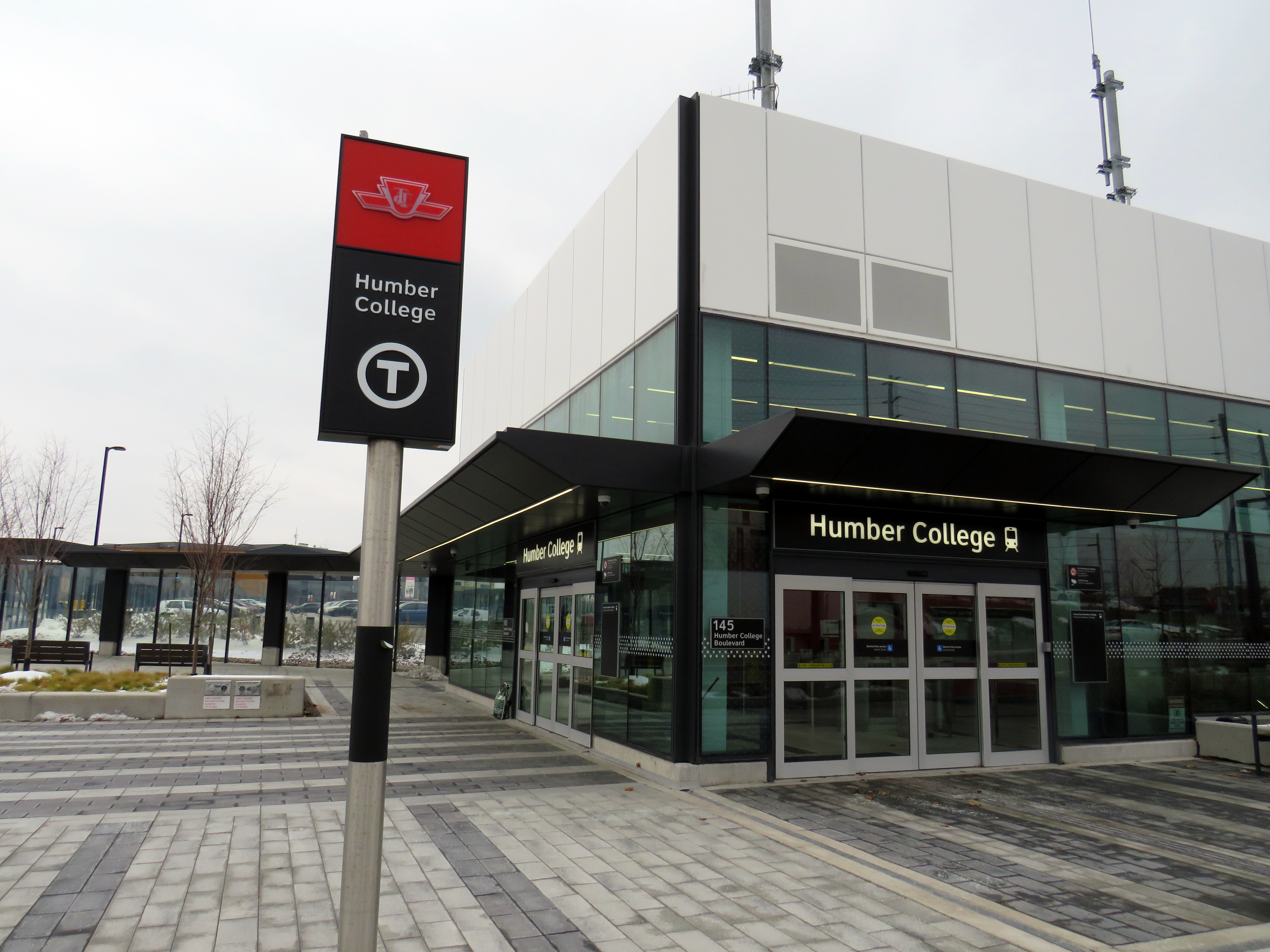
Humber College’s bus terminal serves a total of nine TTC, Brampton Transit, Miway, and YRT routes. It’s also a connection point between TTC Wheel-Trans and Peel Region’s TransHelp paratransit services. But the LRT terminal station is a five-minute walk away from the terminal, which is adjacent to several primary buildings on campus.
A walkway leads between the bus terminal and LRT station, with partial shelter provided by a long canopy that blocks northerly winds, but not the prevailing westerly winds. At the end of the walkway is the entrance to the below-grade LRT platforms, which are parallel to nearby Highway 27. This alignment reduced construction costs over a longer approach to the college, but it permits a future extension to the planned Woodbine GO Station two kilometres to the south and even Pearson Airport.
Humber College Station entrance, at Highway 27. The walkway to the bus terminal and main campus is behind.
During weekday peak periods, the LRT will run every 6 minutes, about as frequent as the current 36C bus during weekday daytime periods. However, during off peak times, trains will only come every 10-12 minutes, resulting in longer waits. Anyone travelling from Humber College will have to factor in the longer walk and potentially longer wait time.
I will certainly go out on Sunday December 7 to celebrate the opening of this new line, which despite the unnecessarily slow speeds, will result in a more predictable and more comfortable ride, with significant capacity improvements during peak periods, especially at school dismissal times. LRT doors will line up with the platforms, making loading and unloading easier for passengers with mobility devices, strollers, or carts.
I will also go ride the LRT after the opening day crowds are done, to see how it works in day-to-day operation. There are ways to speed up the schedule: more aggressive transit priority, shorter station dwell times, quick turnarounds at the terminals with “step back” operation, schedule optimization, and I hope these are considered by Metrolinx, the TTC and the city as everyone gets used to the new transit line.
If you like my work and you would like to help out with my webhosting costs (I just had to renew my ad-free WordPress subscription), consider buying me a coffee.Thank you!
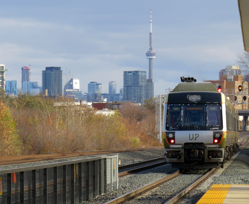
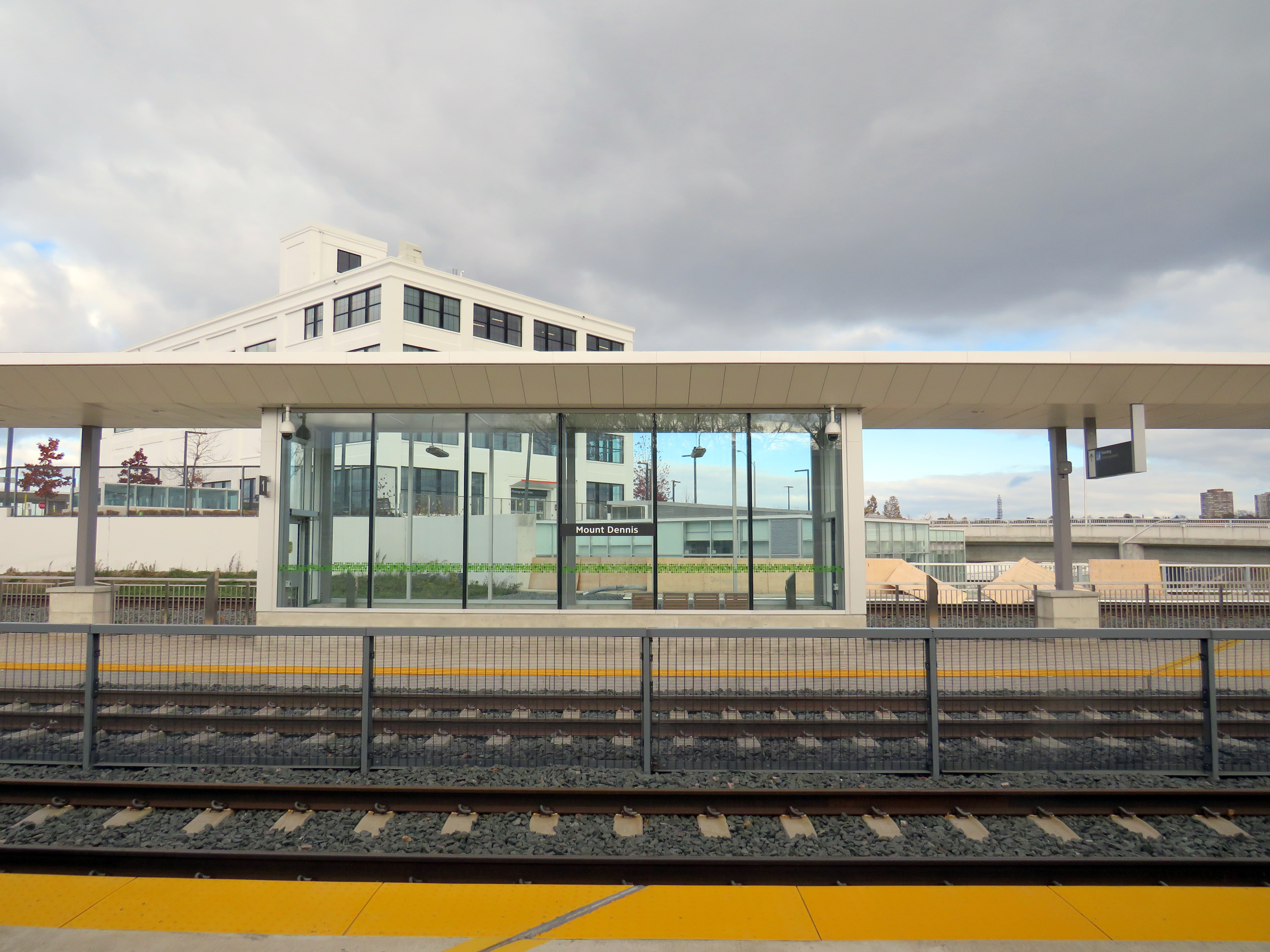
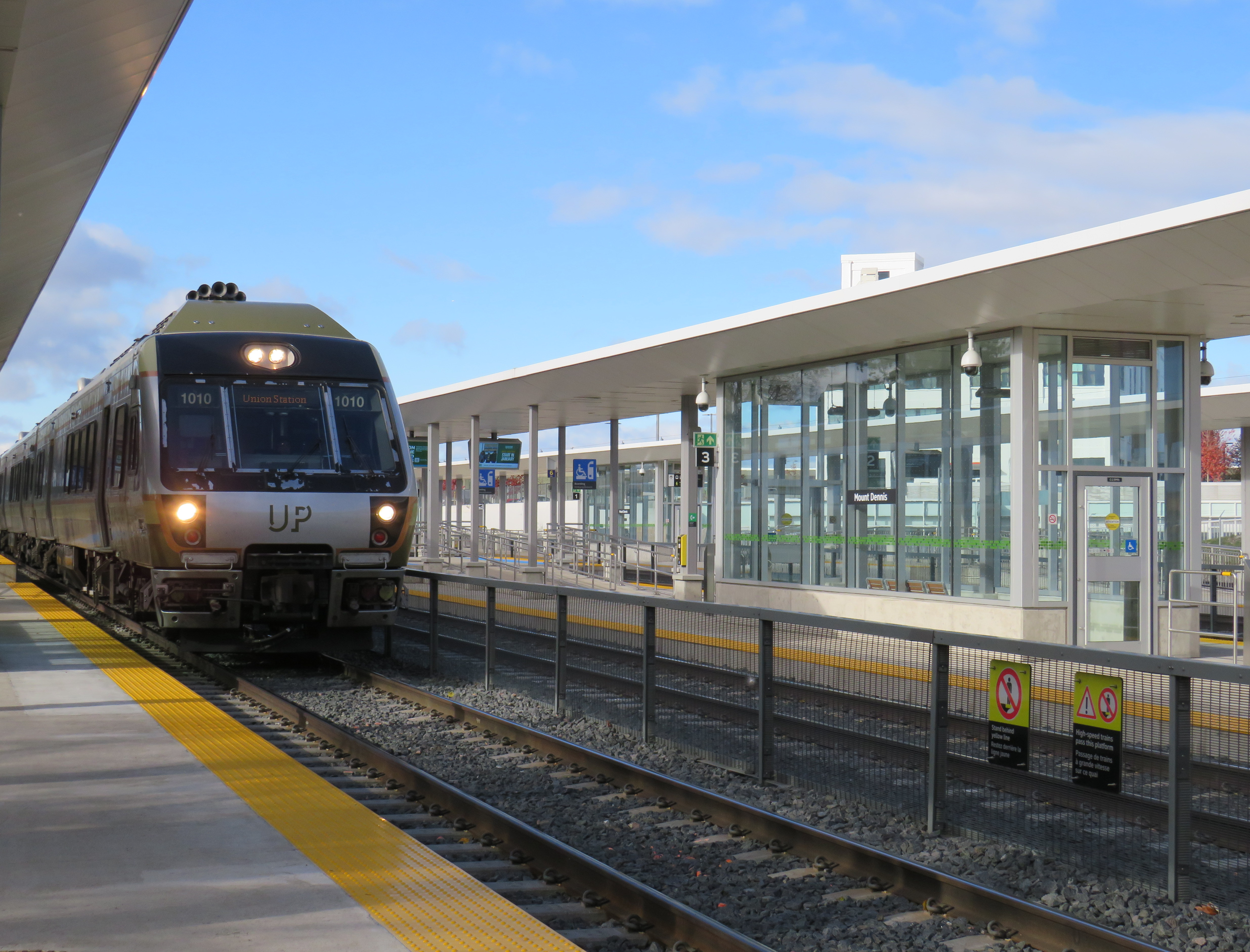
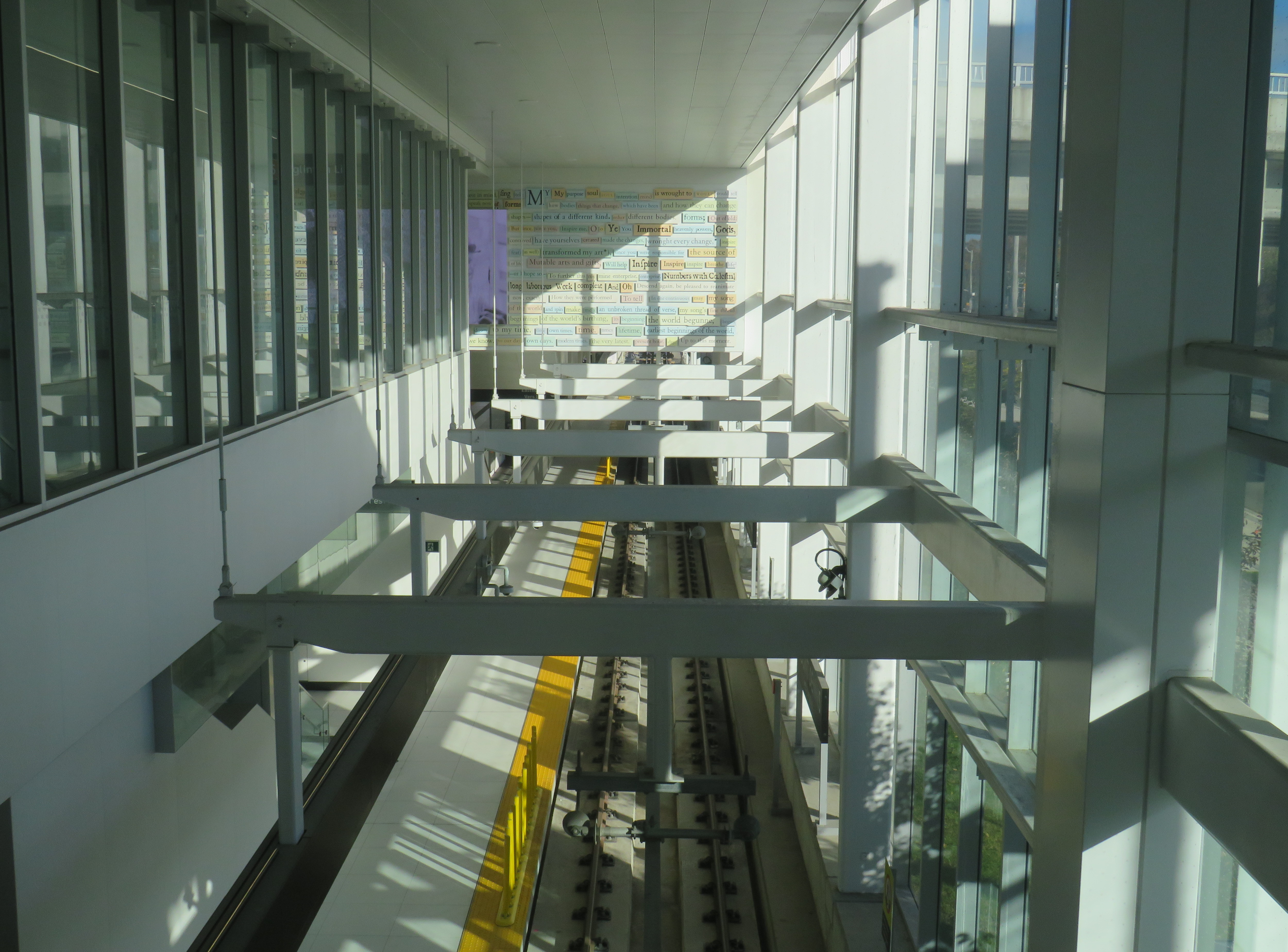
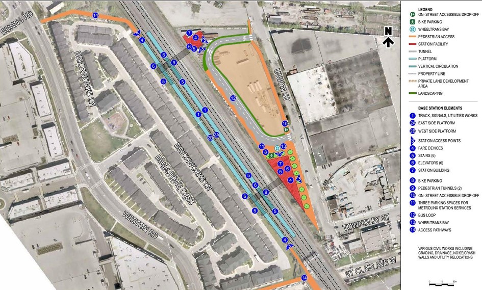
While Montreal was celebrating the opening of another portion of its REM automated light metro system between Gare Centrale and Deux-Montagnes on the region’s north shore, Torontonians had to settle for the partial opening of two light rail stations on the delayed Line 5 Eglinton line: Mount Dennis and Cedarvale.
While the opening of Cedarvale (apart from the light rail platforms) slightly improved circulation at the existing Eglinton West Station, Mount Dennis Station provides for a new GO Transit and UP Express stop, a large TTC bus terminal, and access to a historic Kodak building. It’s an interesting structure that facilitates new intermodal connections, but could definitely benefit from a few minor improvements.
An UP Express train leaves Mount Dennis for Union Station, with the Toronto skyline in the background
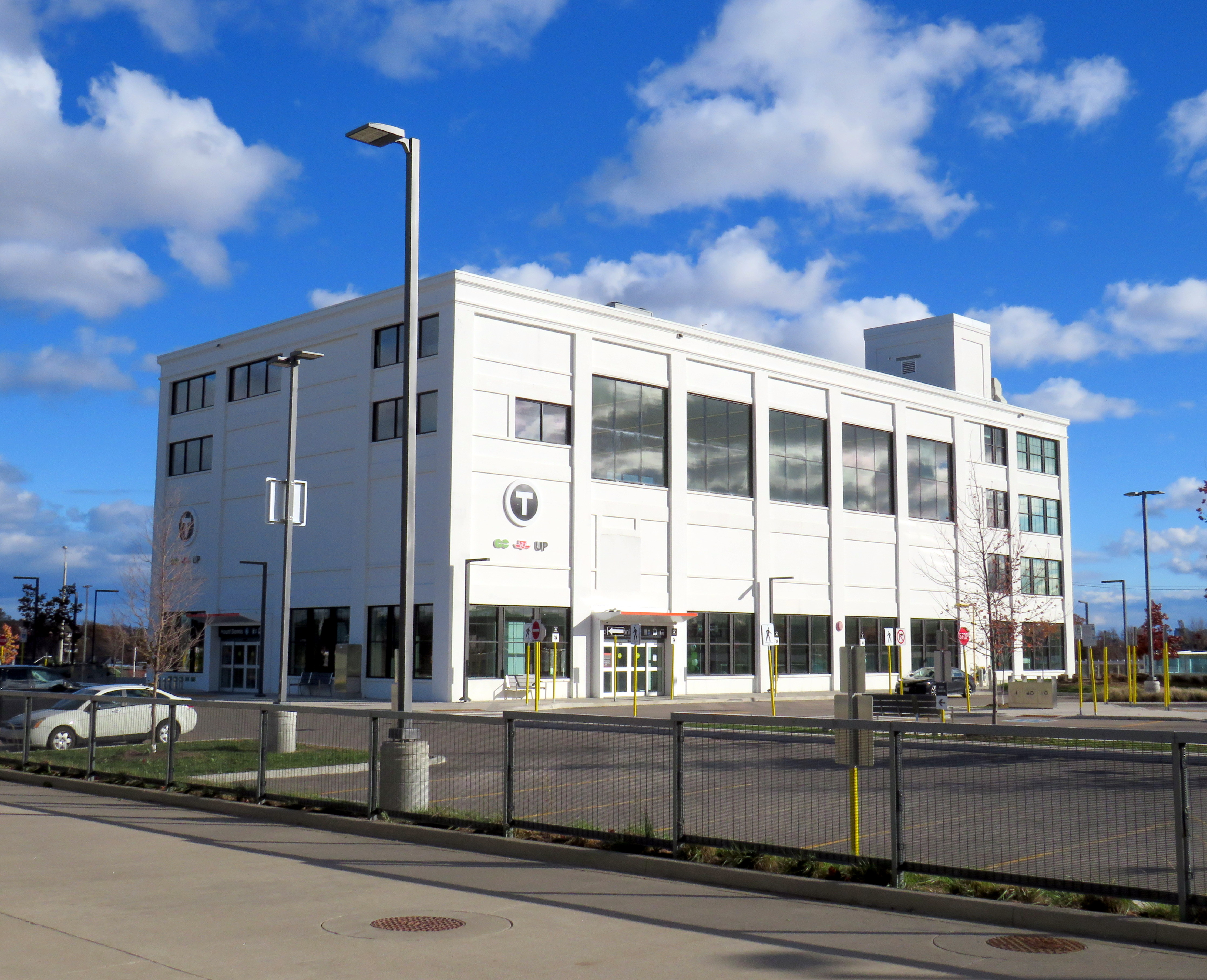
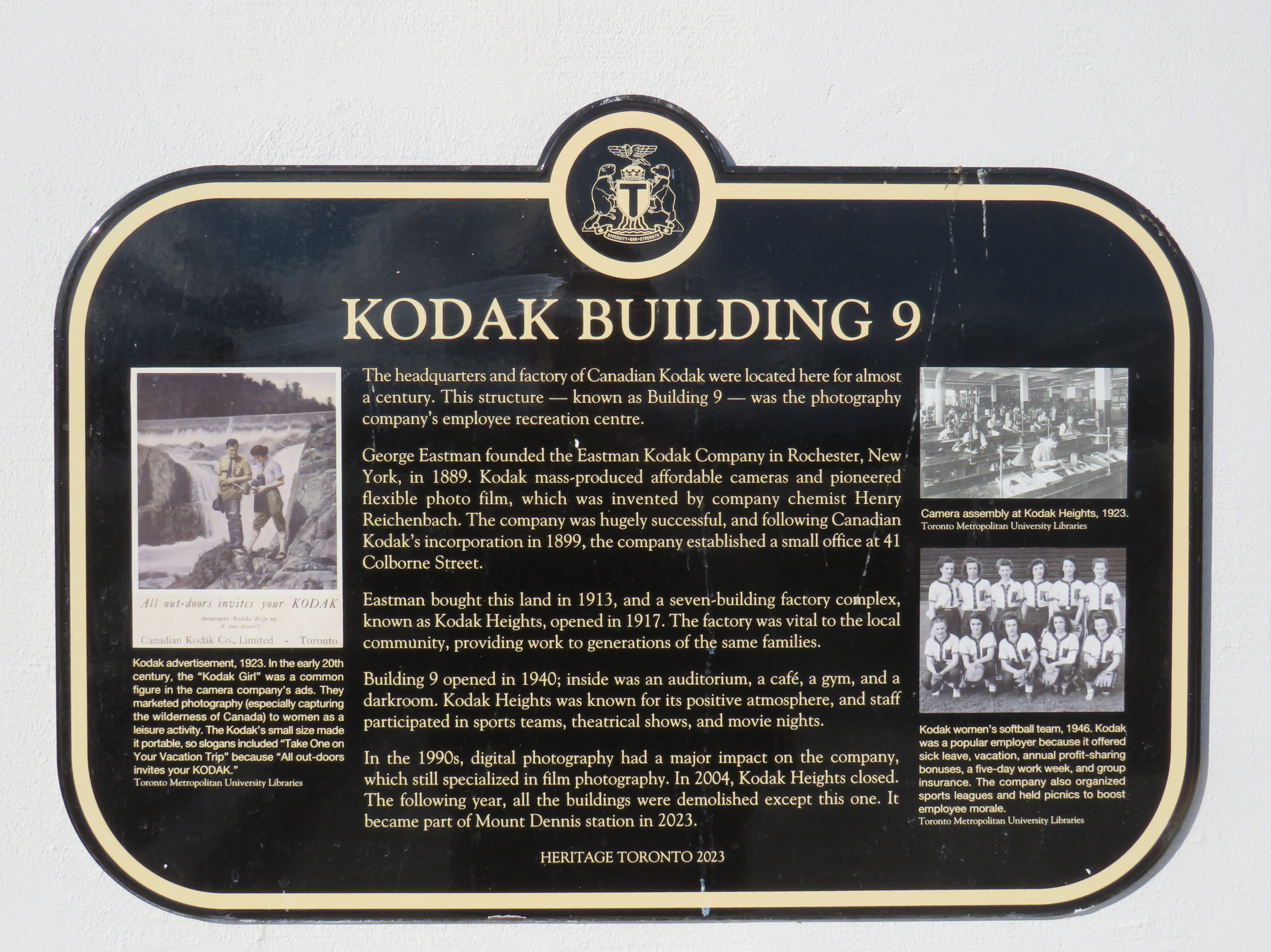
The Mount Dennis and Weston neighbourhoods were established around major industries, including CCM, Moffat Stoves, Willys-Overland, Dominion Bridge, Kodak, with even more employment at the nearby stockyards and slaughterhouses at St. Clair Avenue. The CN and CP railways passing through brought materials in and finished goods out. Today, only the Facelle tissue plant — now owned by Irving — remains in operation from that industrial past. The Dominion Bridge property later became the home of a TTC bus garage, while the Kodak plant became the site of the Eglinton Crosstown light rail storage and maintenance facility.
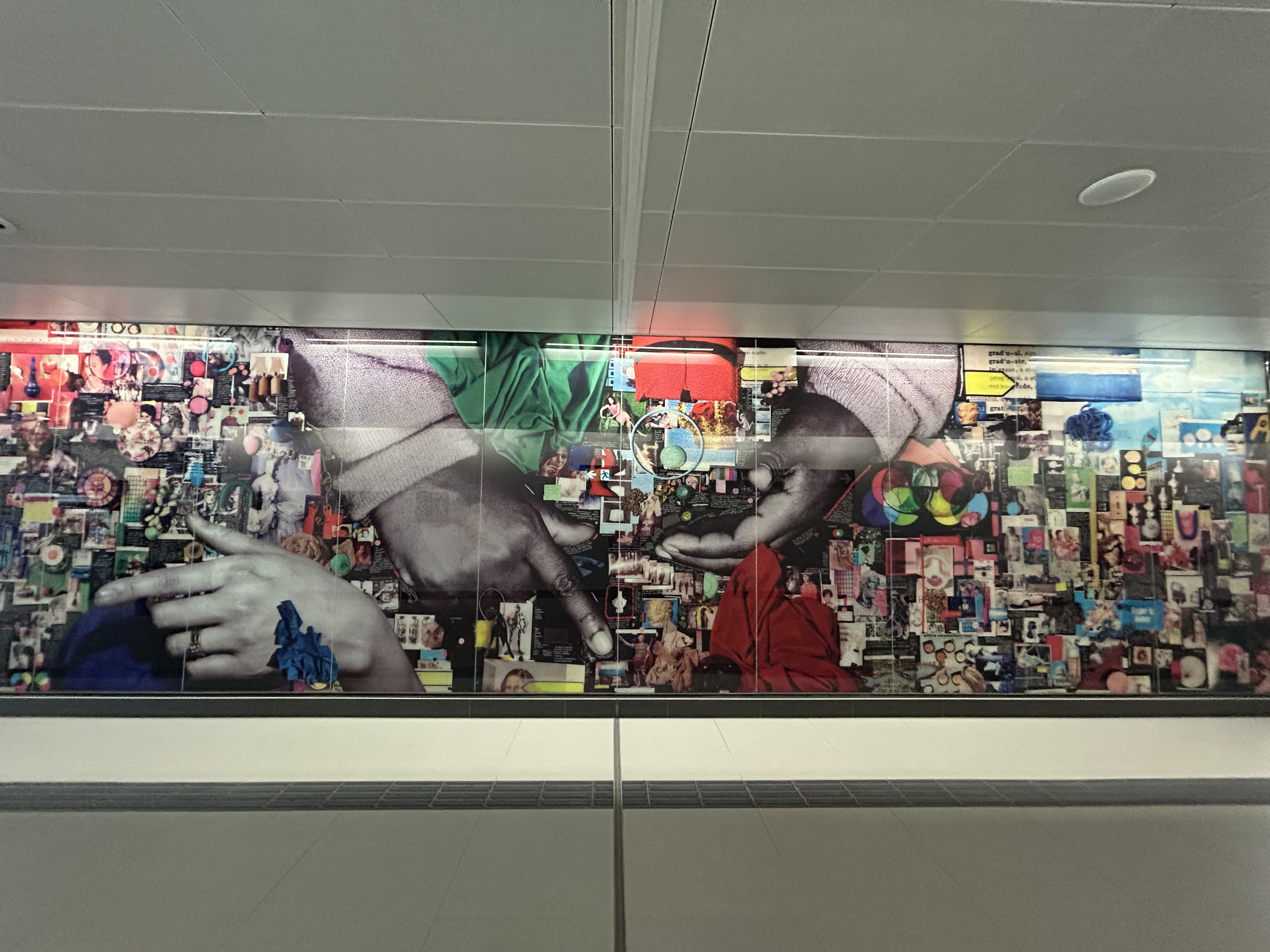
One building from the massive Kodak complex was preserved: Building 9, the employee recreation centre. The rear section of the main floor contains a public entrance to the station from the passenger pick-up and drop-off area, accessible washrooms, and access to the rest of the building (which is currently vacant). A bright mural, which once graced Building 9, can be found near the GO/UPX platform accesses. A heritage plaque tells the story of the building.
Mount Dennis Station platforms and Kodak Building 9Building 9, as seen from the TTC bus terminal. Note the Metrolinx “T” icon, with the logos of three services – GO, TTC, and UP – below.The GO/UP Express section of the station is brightened by a colourful mural saved from Kodak Building 9Heritage Toronto Plaque affixed to Kodak Building 9
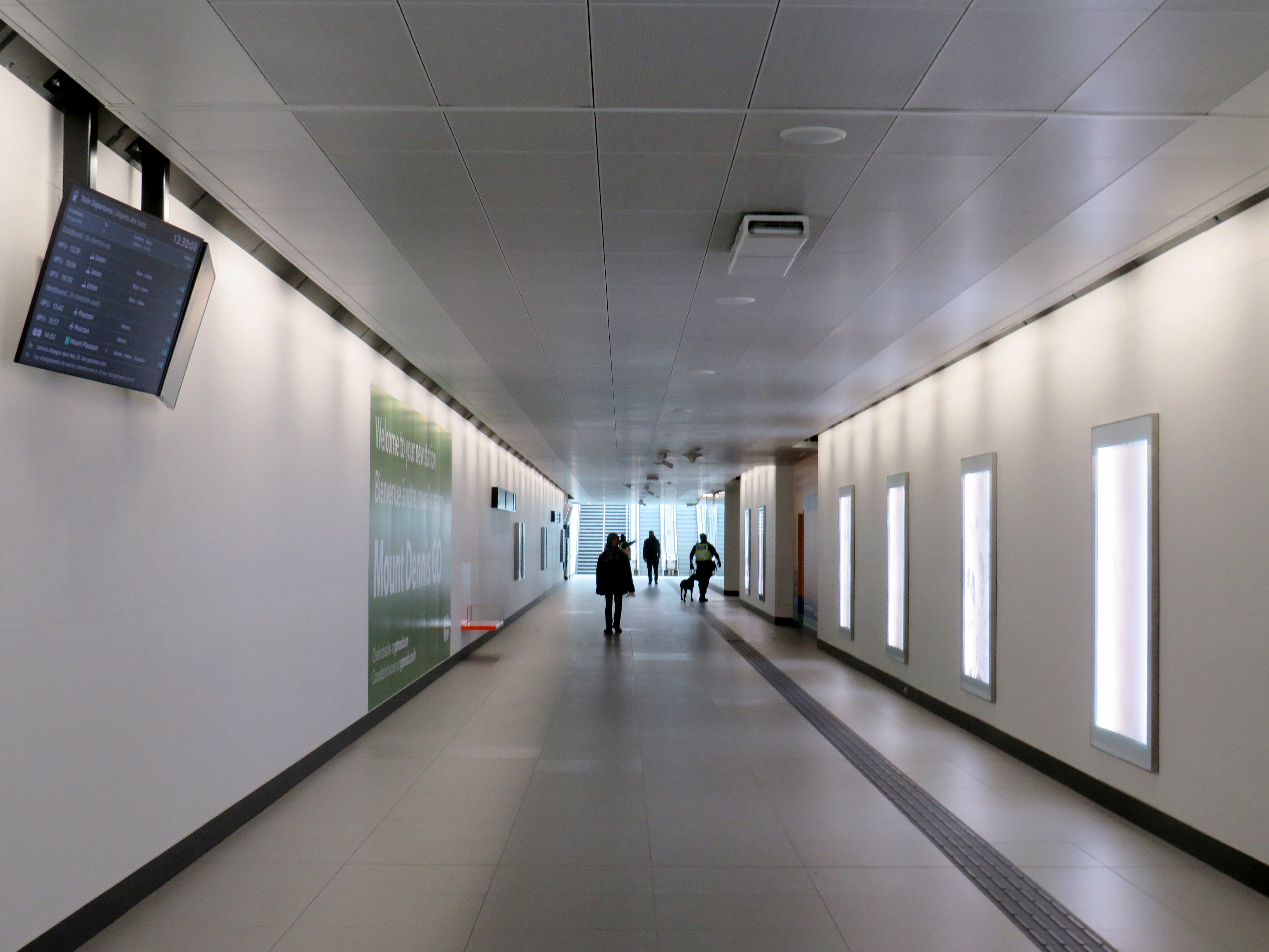
As UP Express and most GO Kitchener Line trains now stop at Mount Dennis, approximately three extra minutes is added to train trips. UP Express, which took 25 minutes between Pearson Airport Terminal 1 and Union Station, now takes 28 minutes. On the first day of stopping service last Sunday, very few passengers got on or off UP or GO trains (of the few that did, most appeared to be transit enthusiasts), but with more TTC bus connections and the Line 5 service hopefully coming soon, the station should become much busier.
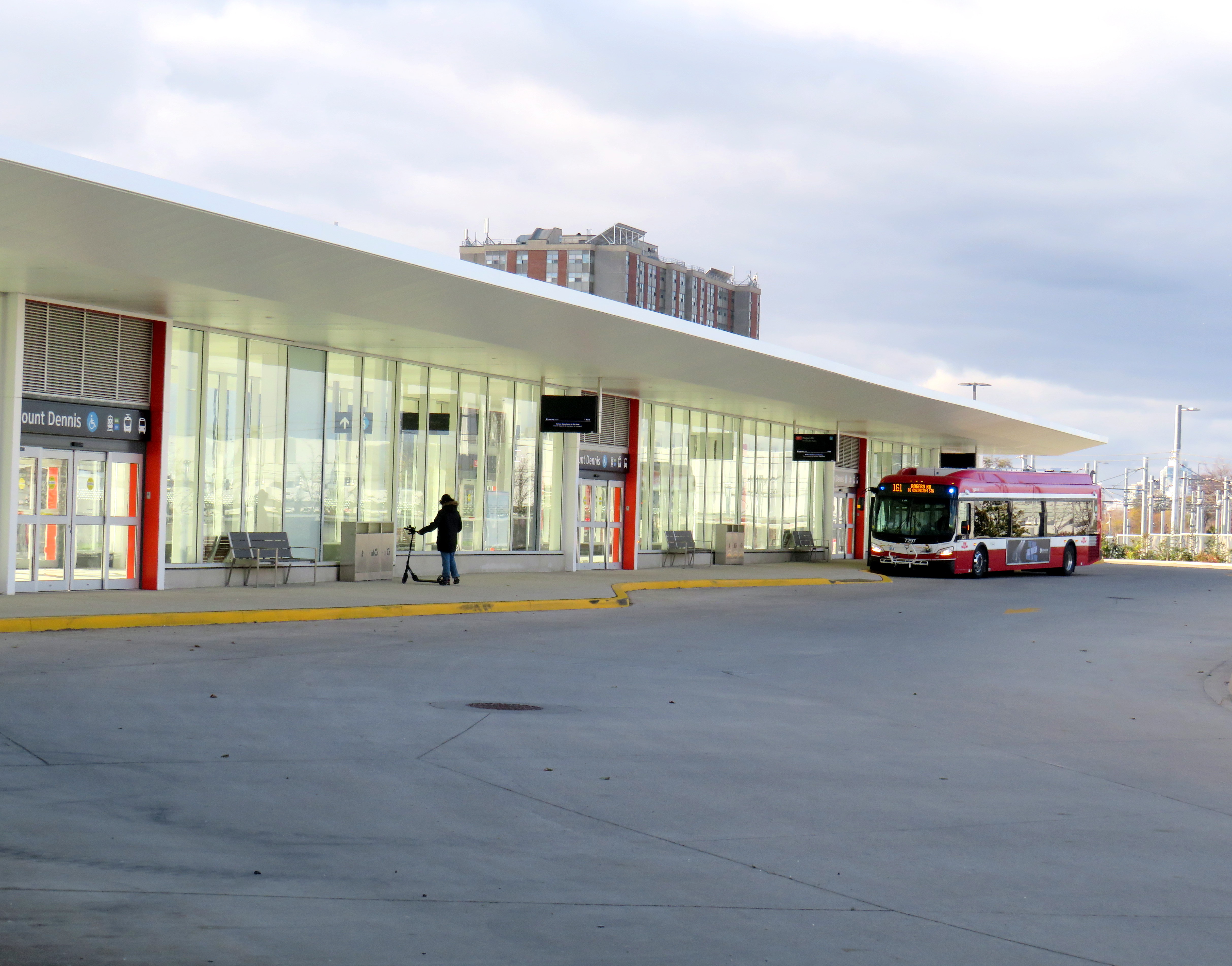
Mount Dennis Station was mostly empty on its first dayA mostly empty Mount Dennis bus terminal currently serves six routes; this will increase to 13 when Line 5 finally opens
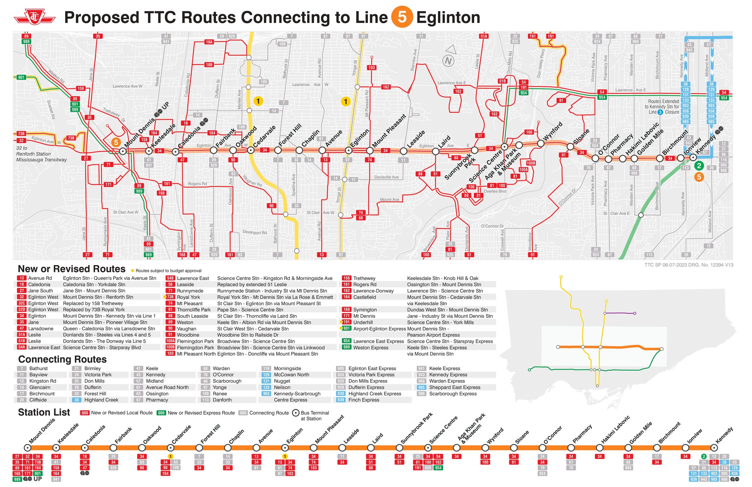
Mount Dennis will be served by 13 different bus routes when the station is fully open, including a new route 901 express between Mount Dennis and Pearson Airport, via Dixon Road. Though most of the changes are simple route extensions to the new terminal (like the 161 and 168), the 35 Jane will be split into two (while the 935 express stays on Jane, bypassing Mount Dennis), and daytime surface service on Eglinton between Mount Dennis and Kennedy Stations will be limited to an infrequent Route 34 bus.
Map of planned bus network revisions upon opening of Line 5 (click for larger image)
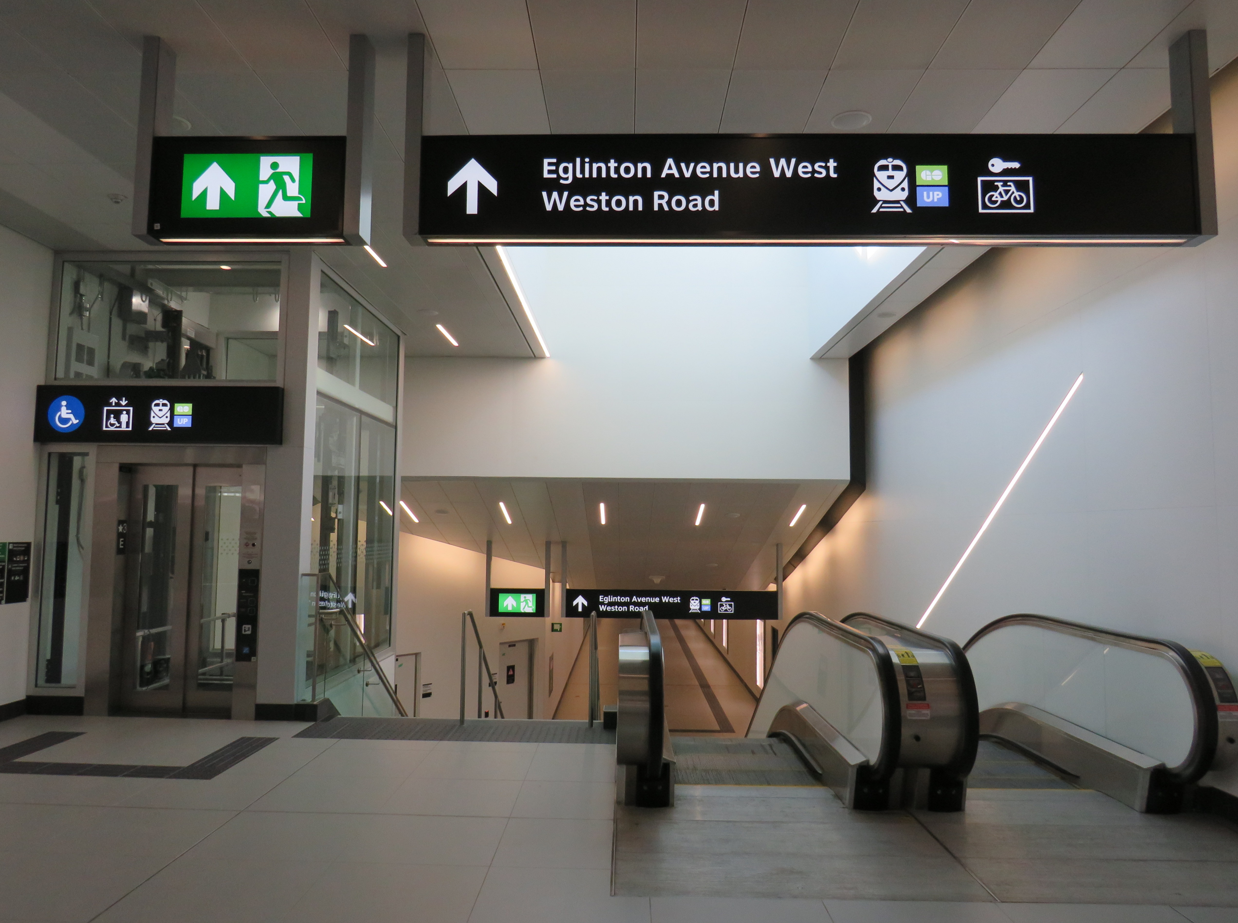
Despite some long corridors (particularly between the escalators up to the bus terminal and down to the closed-off LRT platforms), the station is well designed for the complexity of the site. The bus terminal and LRT platforms are both within the fare-paid area, eliminating one barrier between buses and rail.
Corridor towards the elevator and escalators from the TTC fare gates and LRT to the bus terminal. The natural light comes in from the large windows of Building 9. Public washrooms are on the left, past the windowed room, presumably a future retail space.Looking down to the LRT platforms
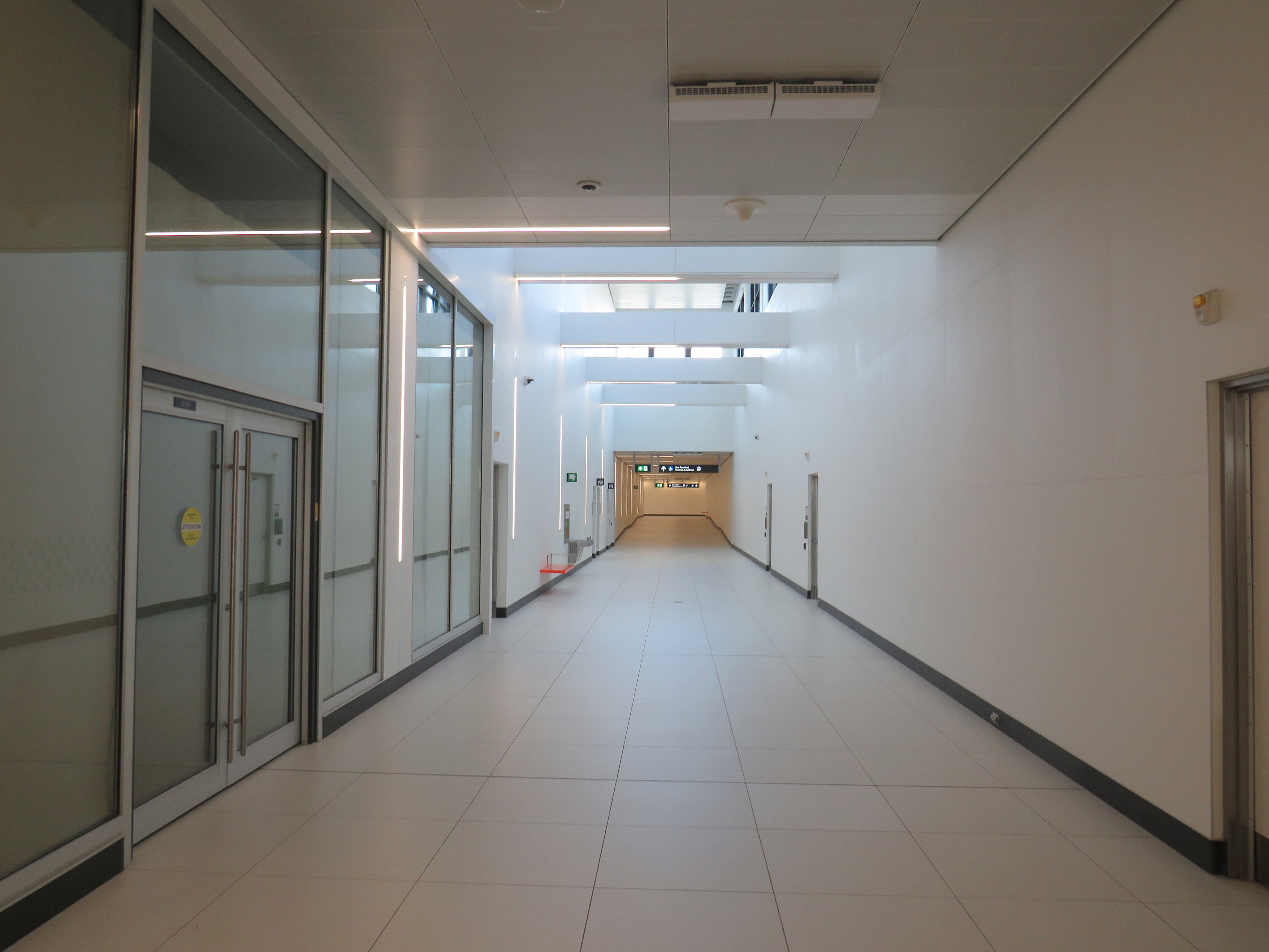
Three of four UP/GO platforms are in service (the fourth track, which would allow for more frequent GO Kitchener Line service is under construction). I was impressed to see two elevators to each platform, providing essential redundancy for improved accessibility and reliability. However, the GO/UPX platform access points are not easy to spot from this long corridor, which also leads to the Eglinton Avenue and Weston Road intersection.
Passage to GO and UP Express trains from the TTC bus/LRT area, looking west
There is no visible wayfinding signage in this long tunnel. Only when one reaches the escalators at the other end are directions apparent, as the overhead signs are affixed to sloped ceilings. This should be a relatively easy fix, but an important one.
No wayfinding signage visible below escalator levelin the GO/UPX area
Furthermore, an opportunity to provide a useful link to the Mount Dennis neighbourhood from GO/UPX Platform 4 (the west-most platform) has not been exploited. An undeveloped road allowance from the corner of Barr Avenue and Brownsville Road, used for station construction, is fenced off and barricaded. This would provide an alternate route to the station from Weston Road, particularly to the nearby Toronto Public Library branch, and would only need a few Presto tap readers and perhaps a fare vending machine. Perhaps it will take private highrise development to make this happen.
Looking west from Platform 4 to the Barr Avenue road allowance
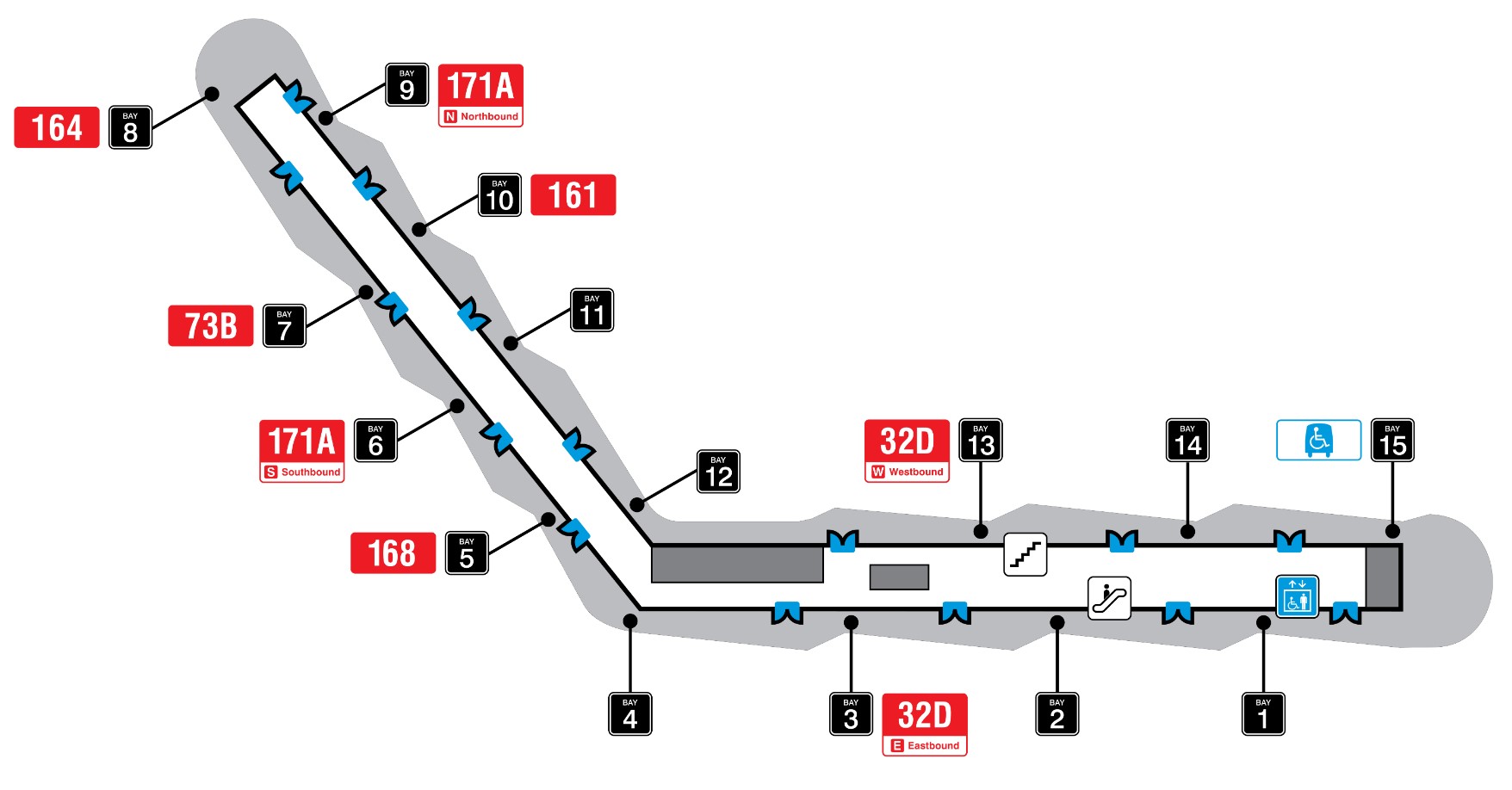
Finally, it was frustrating to see so little wayfinding signage in the TTC bus terminal. Though the TTC has numbered each of the bus bays from 1 to 15, these numbers do not appear inside the waiting area or over the doors. Digital screens over each bay display very small text with next bus information.
TTC bus terminal plan, with each bus bay and assigned routesOutdoor signage at Mount Dennis bus terminal
The wayfinding signage needs to be corrected, but at least these are simple fixes. Otherwise, it was a treat visiting a new transit hub on a sunny (though cold) November afternoon. The heritage preservation was a nice touch; hopefully, new use is found for Building 9’s upper floors. Furthermore, one hopes the rest of the Line 5 Crosstown stations open soon.
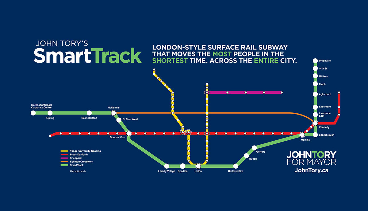
Map of John Tory’s SmartTrack proposal, his signature campaign plank from the 2014 municipal election
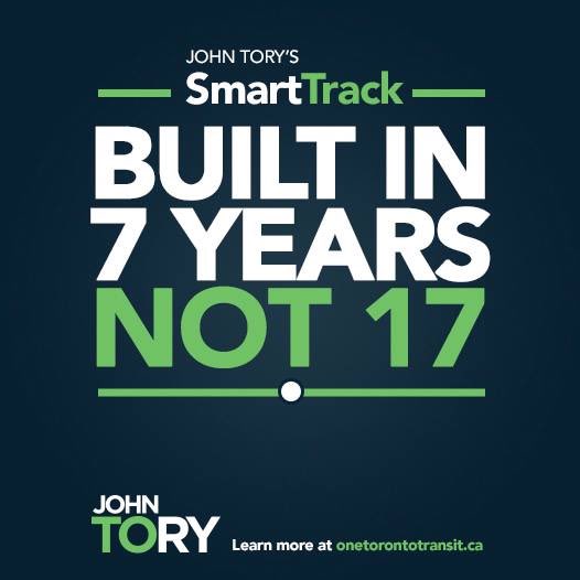
SmartTrack, the transit plan championed by former mayor John Tory in 2014, is the election promise that will never fully die, even if it was diminished from the promise of a brand-new 53-kilometre transit relief project to just a few new stations on existing GO Transit rail corridors. SmartTrack, as initially pitched, would have utilized existing rail and highway corridors to quickly build an express rapid transit line that would provide much-needed relief to the Yonge Subway line, foster development of the East Don Lands (former site of an Unilever soap factory), and connect downtown with employment lands in Markham and Mississauga. According to campaign materials, SmartTrack would have been built in just seven years.
Eleven years later, that relief is coming, but through other forms: the now under-construction Ontario Line, expansion of the Bloor-Yonge Subway station, and slow subway ridership recovery after the COVID-19 pandemic restrictions in 2020-2021. The Mount Dennis-Airport Corporate Centre section, nearly impossible to build as a continuous passenger rail line, is now being built as a tunneled extension of the Eglinton-Crosstown LRT.
Over a decade later, the legacy of SmartTrack, along with other major changes for the GO Transit Kitchener Line, will affect both GO operations and UP Express, Toronto’s airport rail link, which will be asked to do more despite existing constraints. Without rigorous planning, transparency from Metrolinx, and stakeholder input, the potential of Toronto’s northwest corridor as a high-quality local and regional transit project is in doubt. With significant investment and proper planning, the Kitchener Line could serve as a shining example of how to get things right.
The diminished legacy of SmartTrack
It’s possible that three “SmartTrack” stations might be completed in 17 years
The idea of a “London-style surface rail subway” for Toronto was, and remains, a laudable goal for our existing GO Transit rail corridors; this was the concept behind the GO Expansion project touted just a few years ago that would truly transform the system into a high-quality urban rail network. It would not only serve suburban municipalities like Markham, Brampton, and Mississauga, but also improve travel times to the inner suburbs such as Agincourt and Rexdale.
What SmartTrack got wrong was relying on a flawed report that had very specific aims, poor public buy-in, and an arrogant, yet ineffectual proponent who nevertheless managed to win re-election, twice. (He might run again in 2026.) It didn’t help that SmartTrack was a municipal idea that was not coordinated with the provincial planning process; it never really got off the ground, even if municipal planning staff were charged with implementing the proposal. Ideally, the city should have just pushed hard to advance GO expansion on multiple corridors and for fare integration with the TTC.
Despite years of inaction, five SmartTrack stations remain on the books, to be funded largely by the City of Toronto. This was a curious arrangement as the provincial government has taken responsibility for the costs of all other GO Transit expansion projects, along with subway and LRT extensions. The five stations the city committed to were:
East Harbour (Lakeshore East/Stouffville, with a connection with the Ontario Line)
Finch-Kennedy (Stouffville Line) and
Bloor-Lansdowne (Barrie Line, not on the old SmartTrack map)
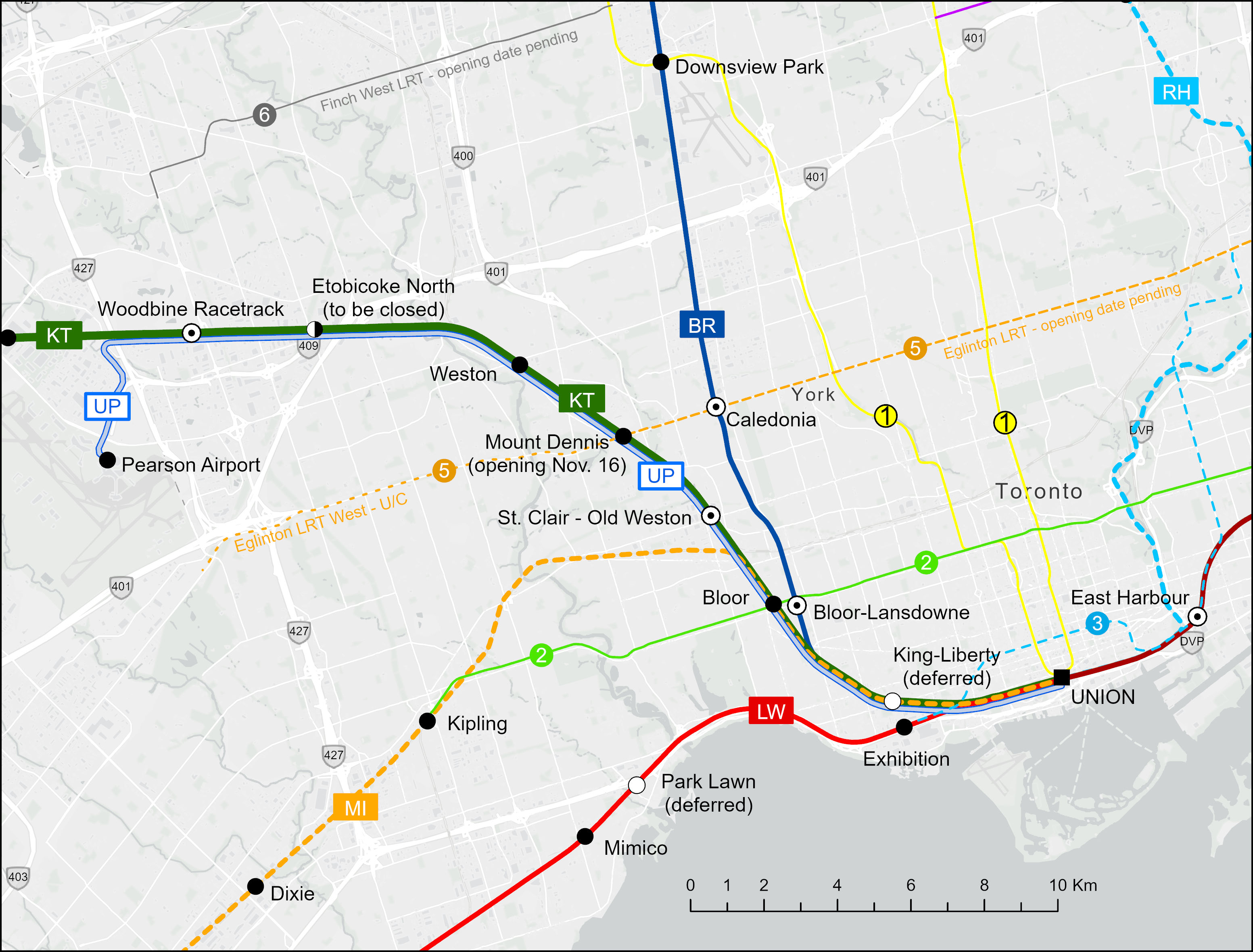
The King-Liberty and St. Clair-Old Weston stations, present in the original SmartTrack map, are on the inner portion of the busy Kitchener Line, which now hosts two-way, all-day service between Union and Bramalea Stations, as frequent as every 30 minutes weekdays. This section of track, known as the Weston Subdivision, also hosts UP Express (UPX) trains, which run every 15 minutes between Union and Pearson Airport, with stops at Bloor and Weston stations. It will also stop at Mount Dennis when that station opens in mid-November, connecting with the Crosstown LRT when that opens, likely in early 2026.
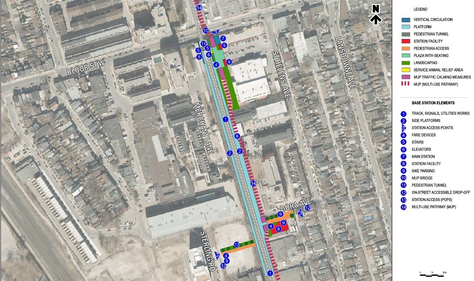
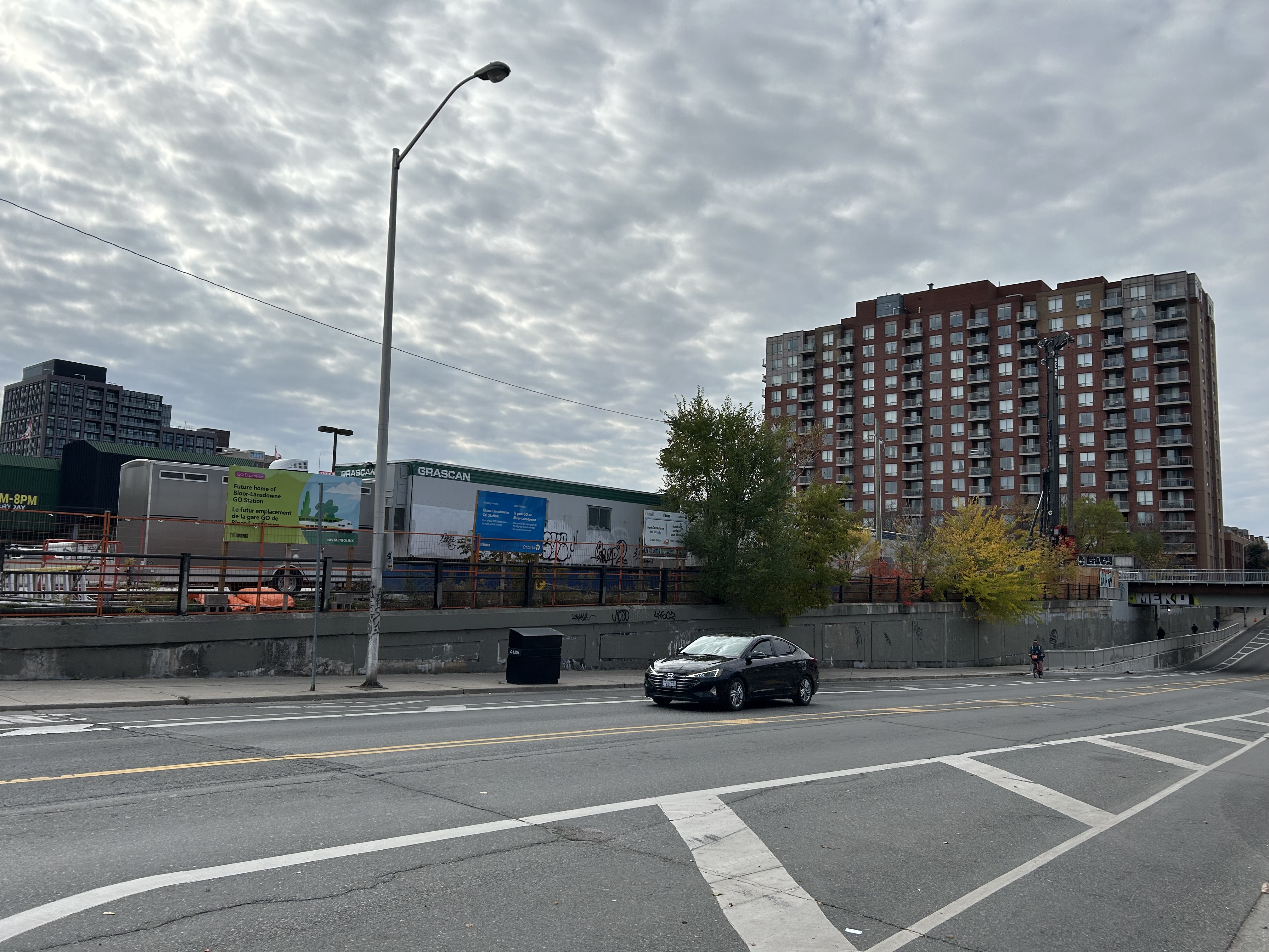
Bloor-Lansdowne is a curious “SmartTrack” legacy station, as it was not on the original proposed route. Located just east of Bloor GO Station on the Kitchener Line, the two-platform station would serve Barrie Line trains, with a walking connection to the TTC’s Lansdowne Station two blocks to the east. (See my supplementary post highlighting this transfer.) Unlike King-Liberty and Finch-Kennedy stations, Bloor-Lansdowne is going ahead as construction had already started in 2024.
Bloor-Lansdowne Station is two blocks west of Lansdowne Station and a 7-10 minute walk to the subway, which runs north of Bloor Street. From 2023 City of Toronto report.
Bloor-Lansdowne probably should not have been advanced, especially when King-Liberty or even Finch-Kennedy would be more useful new stations.
St. Clair-Old Weston Station will still go ahead, even though pedestrian access and transfers to local transit lines will be less than ideal. Rail platforms will be accessed from Union Street, not directly from St. Clair Avenue, Keele Street, or Old Weston Road. Though TTC buses could be diverted to the planned bus loop, transfers to streetcars on the 512 St. Clair line will be awkward and unattractive to riders. (See my supplementary post that describes the challenges in more detail.)
Map of inner portion of GO Kitchener Line, UP Express, and connecting rapid transit lines
Woodbine GO Station (not to be confused with Woodbine subway station on Line 2), located on the Woodbine Racetrack lands, is now under construction. When complete, it will replace Etobicoke North Station, which only has one platform and cannot be easily expanded for a four-track mainline. There is the potential for a short extension of the soon-to-open Line 6 Finch West LRT to Woodbine from Humber College. Woodbine Station would serve both GO trains and UPX, allowing passengers from Kitchener-Waterloo and Guelph to make an easy transfer to Pearson Airport. Woodbine would also be a logical transfer point between local GO trains to Bramalea and Mount Pleasant and express GO trains to Guelph and Kitchener.
With these decisions in mind, the challenge now will be figuring out how to serve the new Kitchener Line stations.
What is UP Express for, anyway?
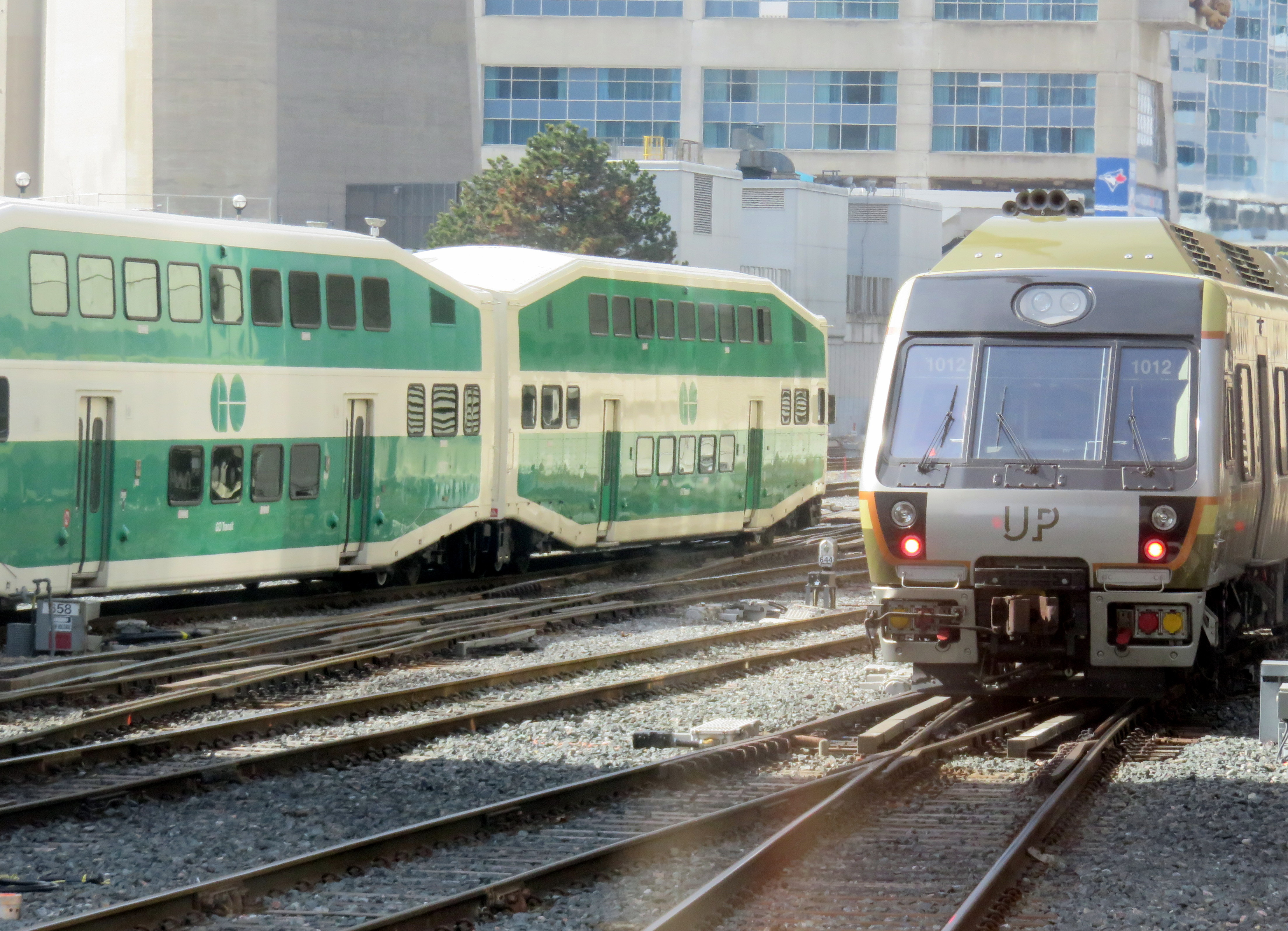
UP Express and GO trains near Union Station
UP Express, for all its faults, is an example of what urban regional rail looks like. Trains are frequent – every 15 minutes – seven days a week, from early in the morning to late at night, with the last train leaving Union at 1:00 AM. Stations feature high-level boarding, ideal for quick and easy boarding, especially for those passengers with luggage, strollers, or using mobility devices. The only other comparable example in North America is Denver’s A-Line train, an electrified service which also makes multiple stop between the downtown core and the city’s international airport.
A 15-minute frequency is important as it is commonly cited as the minimum level of service for a “get up and go” level of transit convenience and attractiveness. Right now, the Kitchener Corridor has a base hourly service between Union and Bramalea seven days a week, with additional peak-direction express trains and 30 minute service during much of the weekday service period.
Because of its reliable and frequent service and affordable fares, UPX has become a victim of its own success, with many riders travelling between Union, Bloor, and Weston, rather than going all the way to and from the airport. This problem was especially evident when riders were left stranded after the end of game seven of the 2025 World Series. The last train left Union station completely full, not long after the game finished in extra innings.
Fares for riding UPX are quite reasonable. When UP Express was first launched, a one-way fare to the airport was $27.50. In 2016, that adult fare dropped to $12.00, today it is $12.35. Adult fares paid with a Presto card are discounted by $3.10. An adult fare between Weston and Union is just over $5. However, UPX despite being owned and operated by Metrolinx, has no fare integration with GO Transit, and it is not part of the provincial One Fare program that permits free transfers between GO, the TTC and other GTHA transit agencies. This is likely intended to minimize overcrowding, even though it limits the utility of UPX.
Another constraint is the UPX fleet and station size. All UPX stations are designed for three-car trains, as the service was designed to be a premium airport rail link, not an urban transit service. There are just 18 Nippon Sharyo DMU rail cars available for service, assembled into four 3-car trains, and two 2-car trains. The interior design is set up for a premium airport service, with rows of forward/backward facing individual seats and lots of luggage space.
These challenges will be exasperated with the addition of new stations at Mount Dennis and St. Clair-Old Weston. Furthermore, Metrolinx has requested that City of Toronto modify plans for the St. Clair-Old Weston (or SCOW) station to be UPX-only. According to an October 21, 2025 report to Council’s Executive Committee, “Metrolinx has indicated that this service change is required to maintain the 15-minute (or better) service frequency commitment made by Metrolinx for the SmartTrack Program, which can no longer be maintained by GO service.”
Despite Metrolinx building a fourth track on the Weston Subdivision that will extend to Pearson Junction (where the UPX tracks diverge towards the airport) from the Union Station Rail Corridor (hence the closures of the West Toronto Rail Path), it seems that it can not commit to operating 15-minute service for both GO and UPX service, which seems like a ridiculous state of affairs when this is common practice in Europe and Asia. This goes against the whole concept of GO Expansion, which promised to deliver fast, frequent, integrated GO service to most of its corridors.
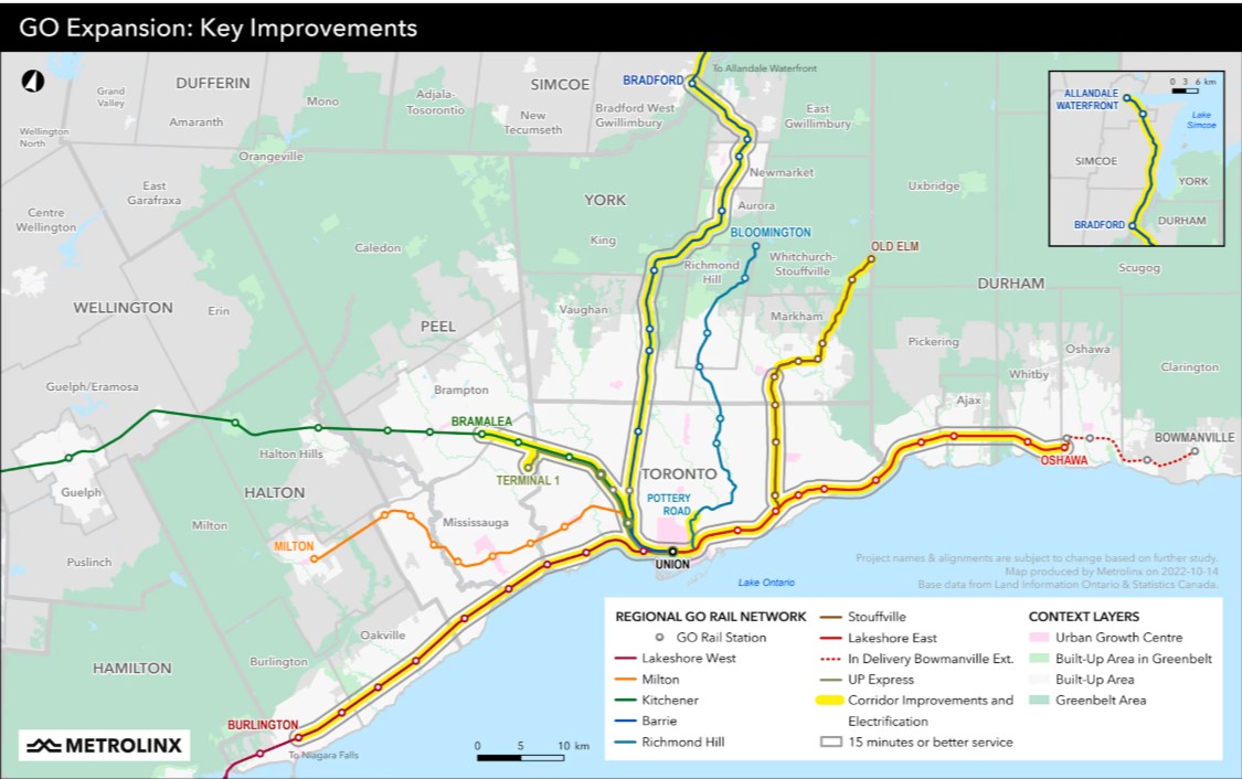
2022 Metrolinx map depicting corridor improvements, electrification, and 15-minute service for the inner portions of the Lakeshore West, Lakeshore East, Stouffville, Barrie, and Kitchener lines.2022 Metrolinx map showing the Kitchener Corridor with “corridor improvements and electrification” for the Toronto-Bramalea inner portion of the line, along with other construction projects between Bramalea and Kitchener.
Perhaps Metrolinx’s inability to conceive of GO becoming more than just a suburban commuter railway is why Deutsche Bahn pulled out of its contract with Metrolinx early in 2025. Since The Trillium’s June 2025 investigation, there has been little said about the collapse of GO Expansion. Communications and transparency have not been Metrolinx’s strong suit, especially in the last few years as Doug Ford’s PC government has tightened its control on all government communications.
So, if St. Clair-Old Weston is served only by UP Express, it will have to be completely rethought. It will not be able to offer an exclusive, 25-minute ride between Terminal 1 and Pearson Airport. That in itself is fine. A train taking 30 minutes to travel the same distance, with a few additional stops will work, provided that the trains have the capacity to serve both airport passengers and urban transit riders. Stations should be six cars long, then, with a new Union Station terminal, ideally under the main trainshed for easy connections to TTC, GO, and VIA Rail. GO Transit trains would then focus on suburban and regional travel between Toronto, Malton, Brampton, Guelph, and Kitchener, skipping most existing stops in the City of Toronto, part from Woodbine and perhaps Bloor.
But Metrolinx, the City, and the Province need to express their intentions openly and clearly so that we, the passengers and taxpayers, know what will happen, and that we will get the best transit possible. Let’s be smart about this.
Bloor-Lansdowne Station construction, November 2, 2025
Bloor-Lansdowne Station, one of five “SmartTrack” stations planned for existing GO Transit rail lines in the City of Toronto, is located just south of Bloor Street West on the GO Barrie Line, and south of the Davenport Diamond grade-separation. The purpose of this new two-platform GO station is to provide a new connection between GO trains and the TTC subway, similar to existing stations like Bloor/Dundas West, Danforth/Main Street, or Downsview Park. Unfortunately, it will not be an easy transfer.
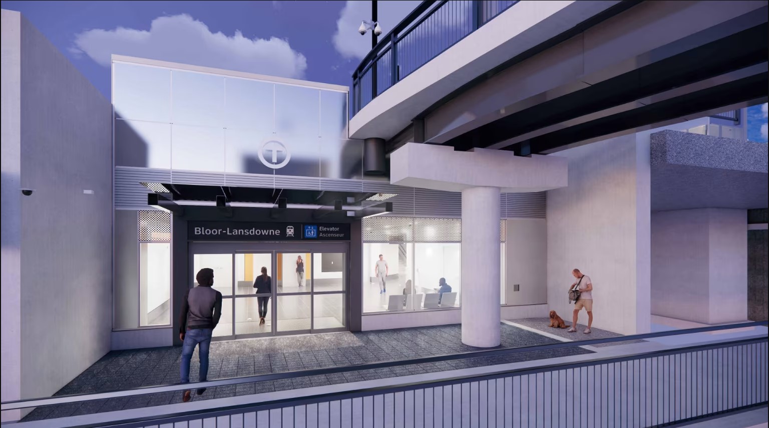
The future Bloor-Lansdowne station entrance, 2025Rendering of Bloor-Lansdowne Station entrance (from Metrolinx web page)
When GO Transit began operations on the Lakeshore Line in 1967, it was built on a shoestring, meant to be a three-year experiment to see if commuter rail would work in the growing Greater Toronto Area. Stations were built cheaply, with asphalt platforms with bus shelters, constructed on easily purchased land for suburban parking lots. At stations like Long Branch and Danforth, connections to TTC subways and streetcars were on-street; most connections would be made at Union Station. When the Georgetown (now Kitchener) Line opened in 1974, Bloor Station was accessed only by narrow stairways down to the sidewalk, with a 4-5 minute walk to Dundas West Station (a direct subway connection is finally nearing completion). Newer GO rail stations, like Kipling (1980-1981), Kennedy (GO platform opened 2005), and Downsview Park (2015), were built with direct intermodal connections, befitting GO’s increasing importance. When it opens on November 16, Mount Dennis GO/UP station will have a direct connection to the future Line 5 Crosstown LRT.
Though Lansdowne subway station is north of Bloor Street and two blocks to the east, the new GO station will be located entirely south of Bloor Street
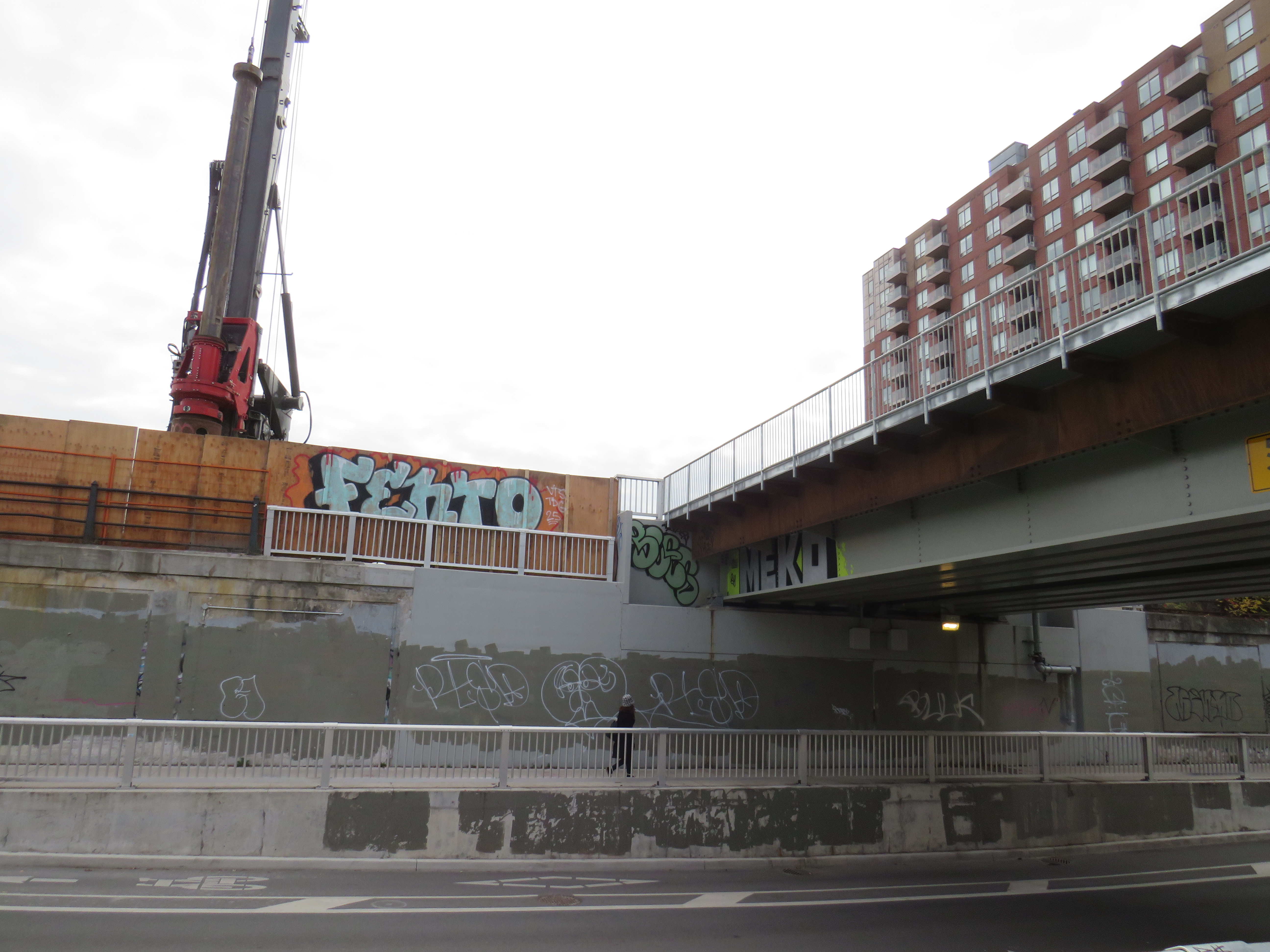
But Bloor-Lansdowne, located next to a former Value Village, will feature a subway-train transfer worse than the current connection between Bloor GO and Dundas West subway station. It took me nearly 7 minutes to get from the Lansdowne subway platform to the planned main entrance below the rail overpasses, including waiting at the Bloor-Lansdowne intersection for a walk signal, and crossing an unsignalized intersection at St. Helens Avenue. (See video below.)
The construction of a new pedestrian overpass connected with the long-delayed Davenport Greenway will provide a slightly more pleasant walking path between the subway and GO train, avoiding a busy signalized intersection. But it will not reduce walking times or the amount of time without shelter from the elements.
Proposed Davenport Greenway
Granted, for some commuters, Bloor-Lansdowne will significantly reduce travel times, especially for those travelling between parts of York Region and western Toronto. But nearby Bloor Station on the GO Kitchener Line will have much better TTC connections and more frequent service with both GO and UP Express service and will be a much more attractive route towards Downtown Toronto. Compared to the benefits to riders on the 39/939 Finch East — the TTC’s busiest bus corridor — that Finch-Kennedy Station will offer, or the benefit of King-Liberty’s GO and UP Express service to riders in Liberty Village, Parkdale, and West Queen West with King-Liberty, Bloor-Lansdowne has limited ridership potential.
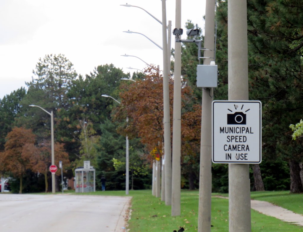
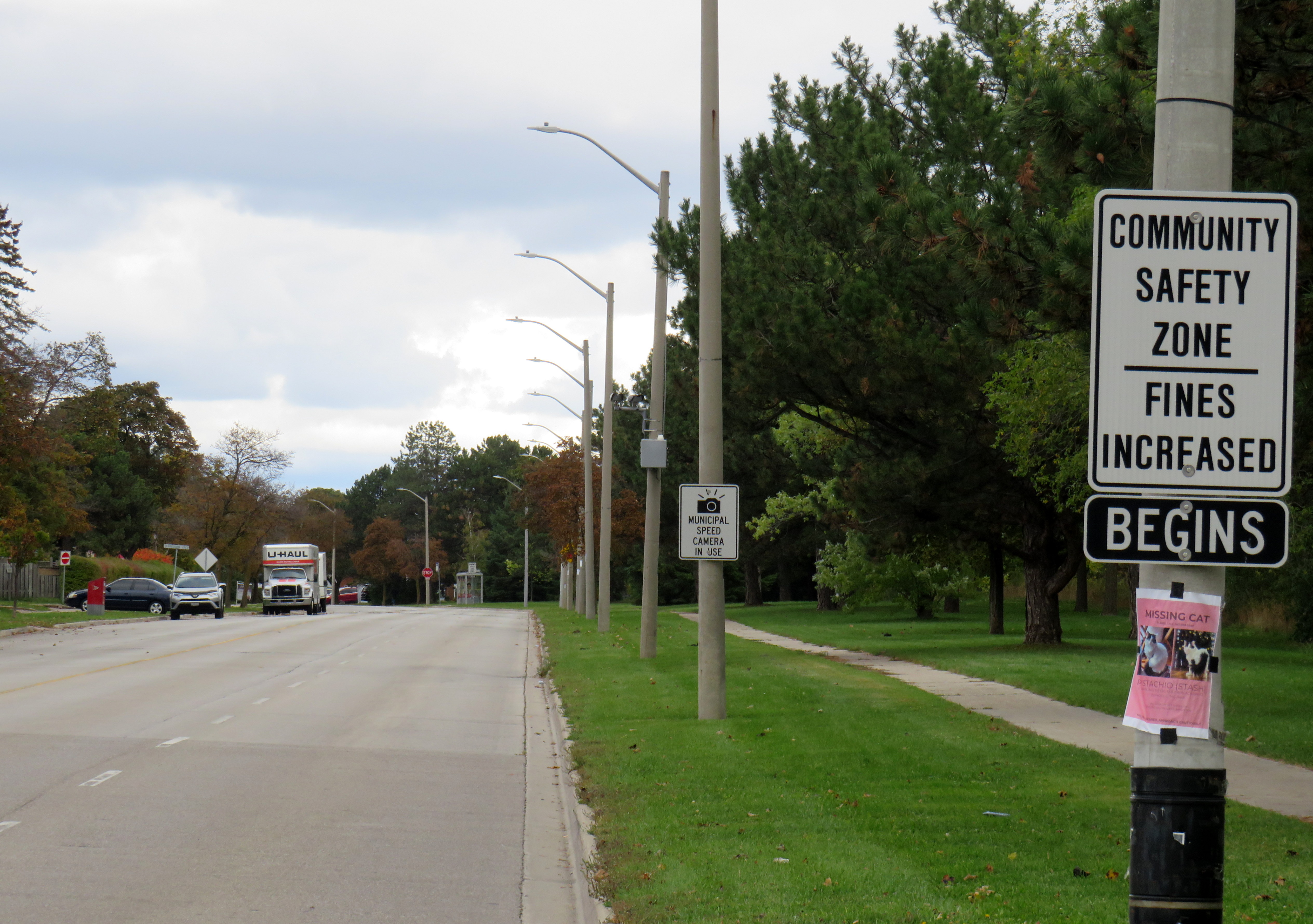
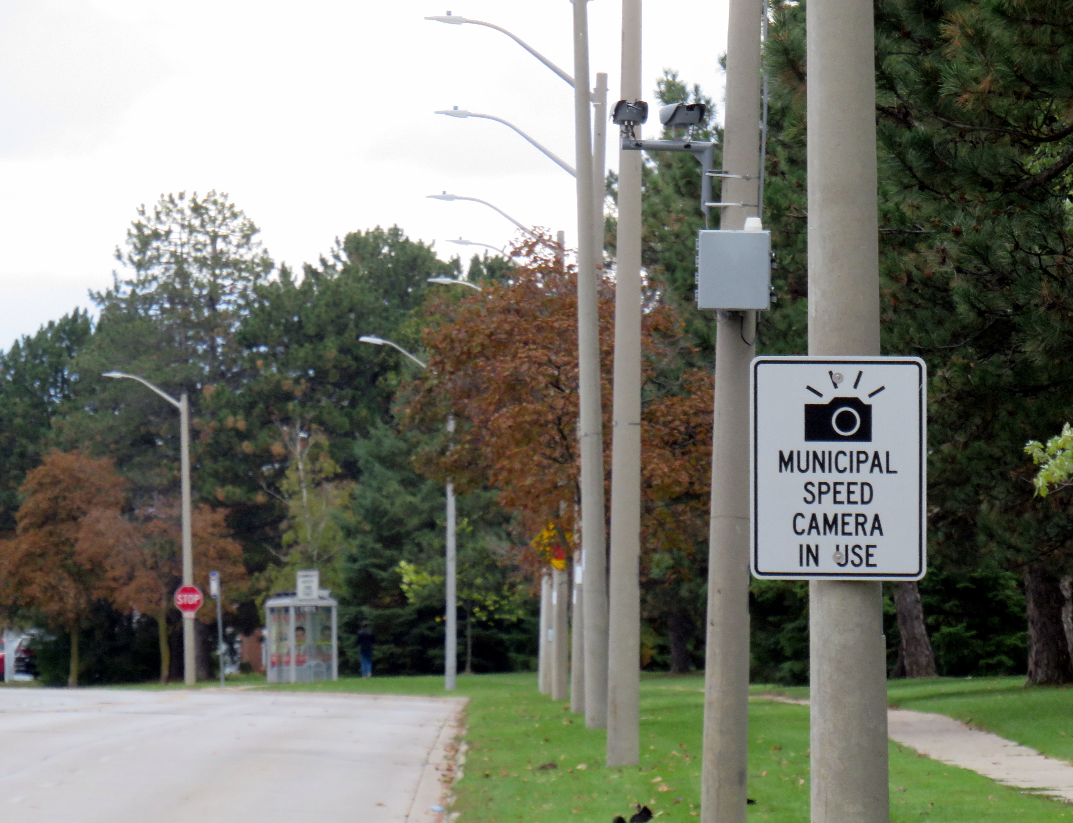
Dearbourne Boulevard, a four-lane collector street designated a community safety zone
Last week, while visiting Brampton, I came across one of the hundreds municipal speed enforcement cameras that Premier Doug Ford’s government wants to rip out across the province. The camera, on a four-lane collector street in Bramalea, is in a residential area, adjacent to several parks, including a pathway to a local public school, in an area designated a community safety zone. This is precisely the type of place that the government intended speed enforcement cameras would go when they were permitted under provincial legislation in 2019.
In a September 2025 government press release touting the move as “protecting taxpayers,” Ford, whose government was in power when these cameras were permitted, claimed that the program became “a cash grab;” supporting quotes included those from former Liberal leader and current Vaughan mayor Steven Del Duca, a representative of the province’s municipal police unions, and a spokesperson from the right-wing Canadian Taxpayers Federation.
If only there was a simple, effective way for taxpayers to avoid the so-called “cash grab.”
It was interesting who was not quoted in that press release, including doctors, educators, safety advocates, and even police brass. Ontario police chiefs support automated speed enforcement. It is also worth noting most municipalities support the cameras; Vaughan is one of only a few municipalities that recently rejected the road safety program; Del Duca was joined by just two other conservative-leaning mayors.
Of course, the arguments against the cameras, which in Toronto, were repeatedly vandalized or stolen, never held water. There were no tickets mailed out to drivers going just a few kilometres over the limit. Furthermore, speed enforcement was never a “cash grab” as the fines collected went to pay for the administration of the program, to “Vision Zero” works, such as the installation of speed cushions and improved pedestrian crossings, and to the province, which the collects the victim surcharges added to every Highway Traffic Act fine. The City of Brampton found that not only were the cameras effective in reducing speeds, they had the support of a majority of its residents.
Municipal speed camera
That said, while visiting Dearbourne Boulevard, I realized that speed enforcement cameras on their own are not effective in creating safer streets.
Dearbourne Boulevard serves one of the oldest parts of Bramalea, established in the early 1960s as a self-contained satellite town, where residents were expected to drive to most destinations. After amalgamation into the City of Brampton, traffic increased and more transit became available. Nearby, several newer high-rise apartment buildings were built, walking distance to Bramalea GO Station. A bus route, 16 Dearbourne, runs along the street, connecting the neighbourhood with several shopping plazas, the GO Station, and the transit hub adjacent to Bramalea City Centre.
Despite having low traffic and serving a residential area (an industrial area is just to the south, but it is inaccessible from Dearbourne), it is still a wide four lane street. The only traffic signal is at Bramalea Road; there are two all-way stops at Delamere Drive and Dorchester Road. At the east end of Dearbourne, the T-intersection with Balmoral Drive is controlled only be a stop sign, with two long and gentle right turn slip lanes. The speed limit is 50 km/h, and there are no speed cushions, curb extensions, or even painted buffers to indicated that drivers should go slower. In October 2022, a pedestrian was struck and seriously injured at one of the two all-way stop intersections; the driver fled the scene.
Though to its credit, the City of Brampton has been improving many suburban streets and roads to reduce speeds and promote walking and cycling. Charolais Drive, Vodden Street, Central Park Boulevard, and Vodden Road saw traffic lanes replaced by new cycling lanes, with little pushback from residents. Dearbourne Boulevard was also slated for improvements in 2021-2022, but that work was not yet started.
Central Park Boulevard, Howden Boulevard, and Vodden Street were among several four-lane collector roads tamed with new cycling infrastructure in the last five years, creating a new through east-west cycle route
Now, it might be too late. Not only will the speed camera be prohibited under a bill being rushed through the provincial legislature (going around the consultation process where concerned citizens, advocates, or safety experts could depute to MPPs), but another omnibus bill was just introduced, which if passed, would prohibit all Ontario municipalities from removing general traffic lanes to install cycling infrastructure, or even transit lanes and on-street patios.
Given the provincial government’s increasing hostility to anything that inconveniences drivers, be it road tolls, vehicle license renewal fees, automated speed enforcement, or bike lanes, it leaves municipalities fewer options to protect their most vulnerable road users and promote sustainable and healthy transport options. Though Doug Ford claims that alternatives like flashing lights and more signs would do the trick, they do not do much to deter aggressive and dangerous drivers, unlikely to get caught.
For streets like Dearbourne Boulevard, there are a few options. Lowering the speed limit to 40 km/h should be a first step. The redundant outer two lanes could be converted to parking-only spaces, with curb extensions and bollards at intersections. The slip lanes at Balmoral Drive should be ripped out.
Roads designed in the 1960s and 1970s for traffic that never really materialized need to be rethought, with or without Queen’s Park’s support.
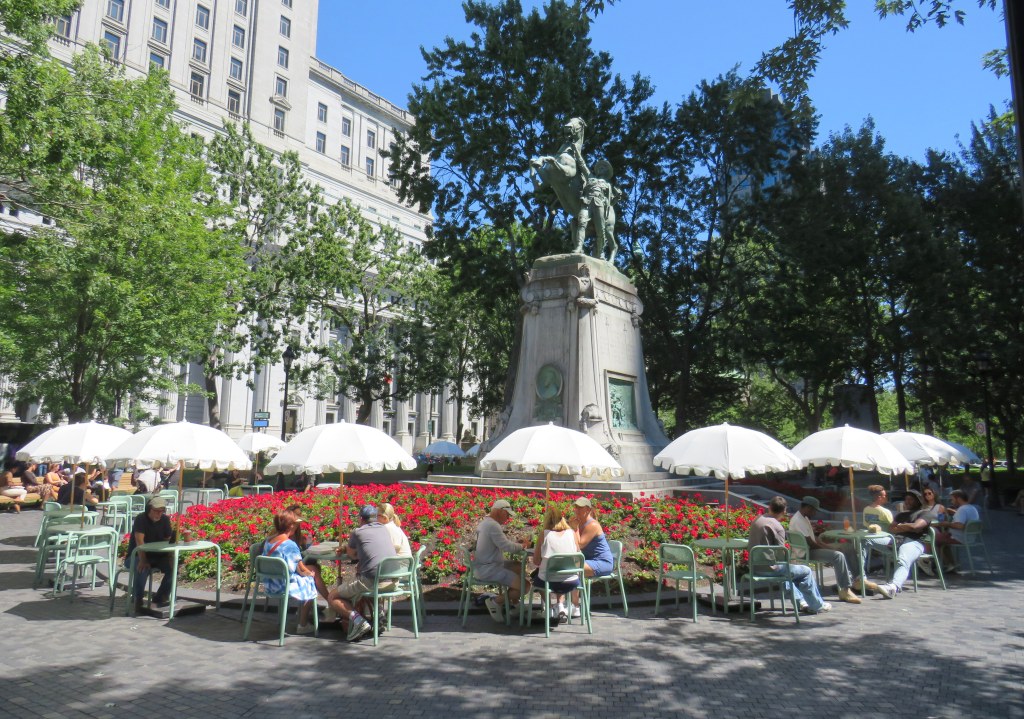
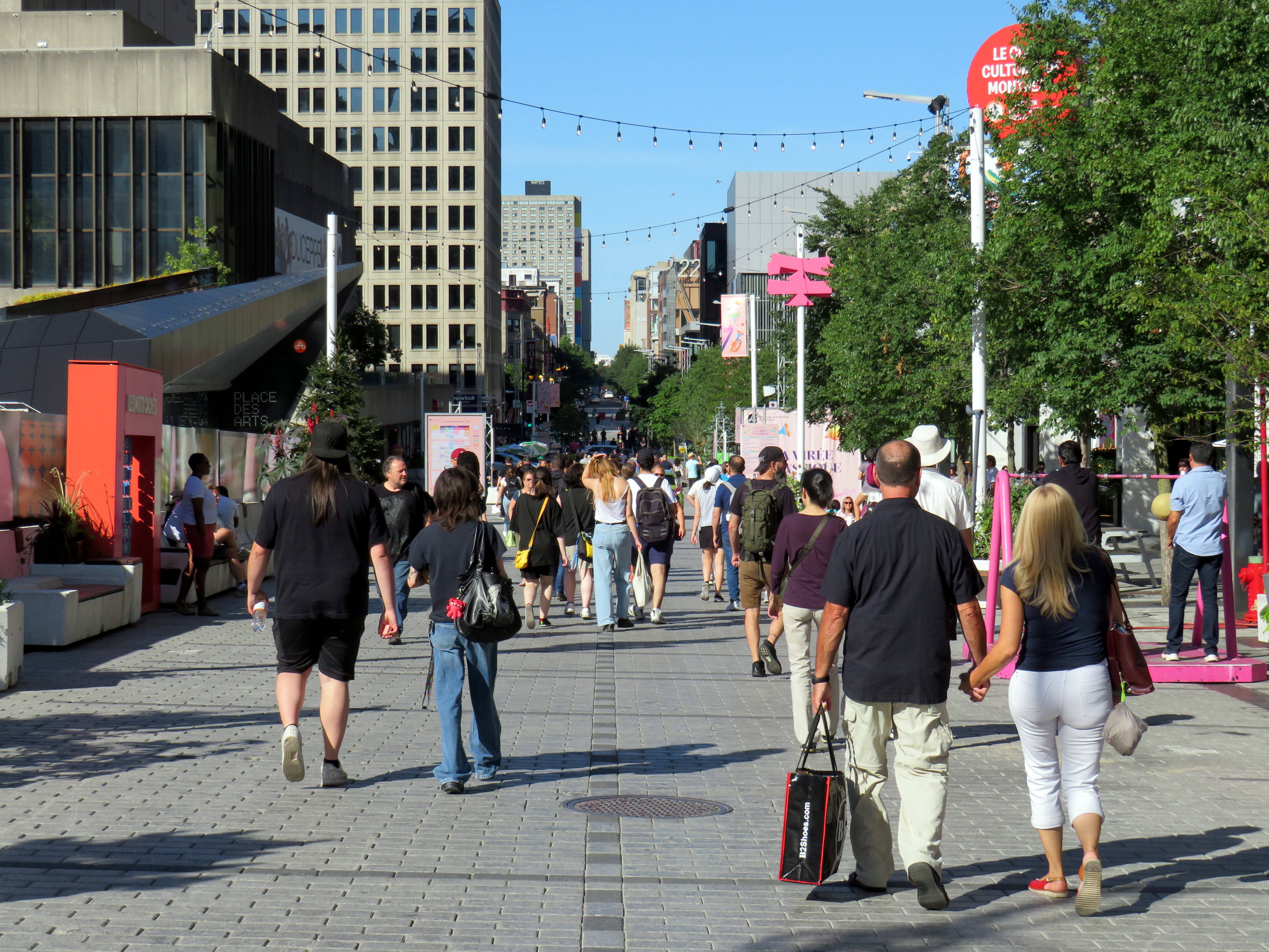
Rue St-Catharine in the Quartier des Spectacles, August 2025
A visit to Montreal can make one jealous. Jealous of the city’s better street furniture, greater cycling infrastructure, great public spaces throughout the city, and an improved pedestrian realm. Entire streets are closed in the summer months to motor traffic, allowing pedestrians to spill out into the roadway, and patios to sprout without the need for concrete blocks to protect them (and less noise and pollution to those dining al fresco).
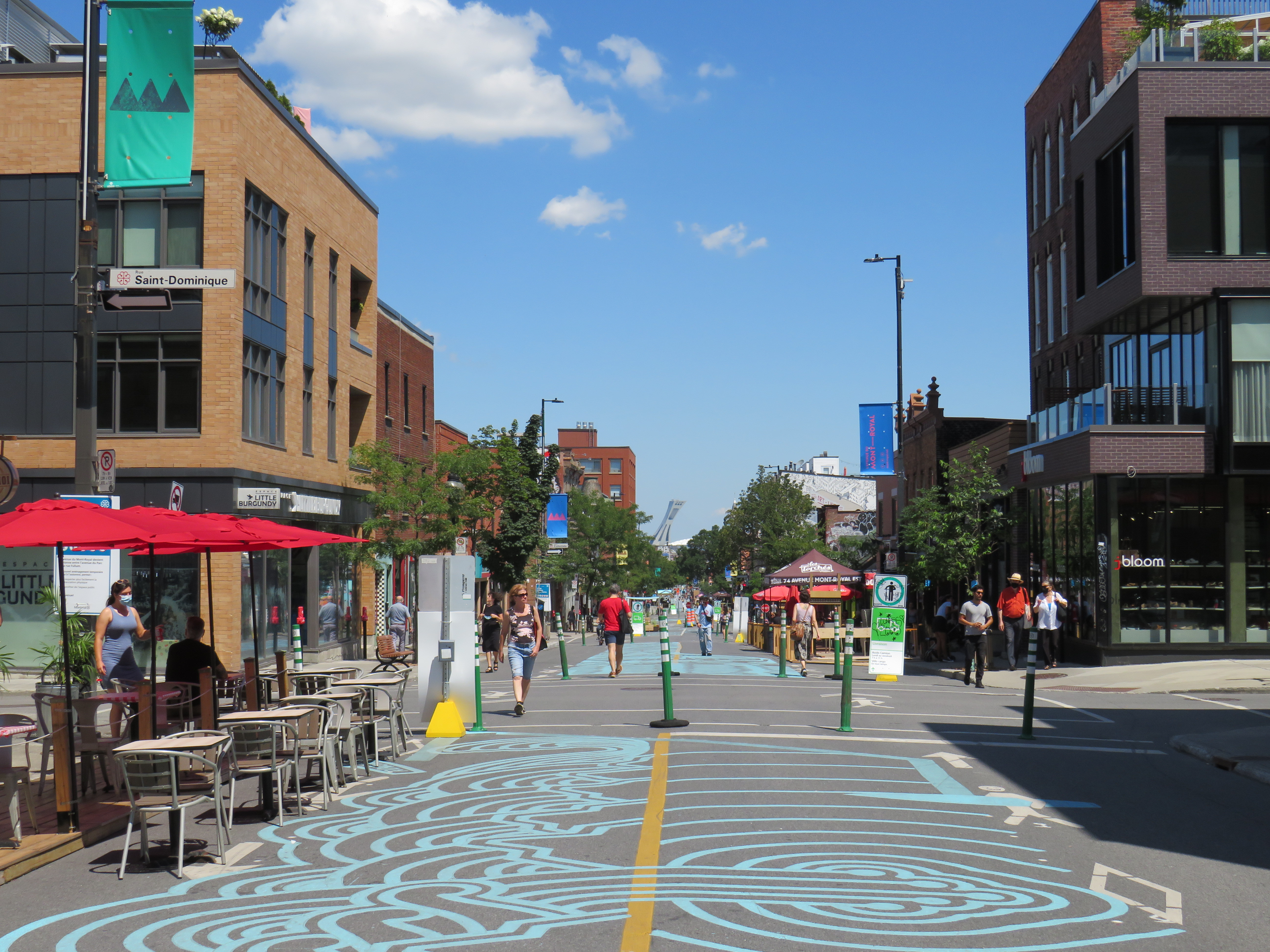
For example, Avenue Mont-Royal, was first closed in Summer 2020 as a “Corridor Sanitare” to encourage people to get outside during the first wave of the COVID-19 pandemic and support local businesses, which set up patios on the sidewalk and the street. My spouse and I rented a car and visited Montreal during this time, getting a lot of walking in a city that opened up as much as safely possible.
Avenue Mont-Royal, looking east, August 2020
Happily, Montreal continued the tradition in the years since, even as pandemic restrictions eased, then disappeared entirely. Five years later, Avenue Mont-Royal was even more vibrant. Not only were there lots of patios on the street, there were public benches, shade structures, and water fountains, allowing anyone to sit, relax, and enjoy the outdoors. The annual summer closure is a hit.
Avenue Mont-Royal, looking east, August 2025
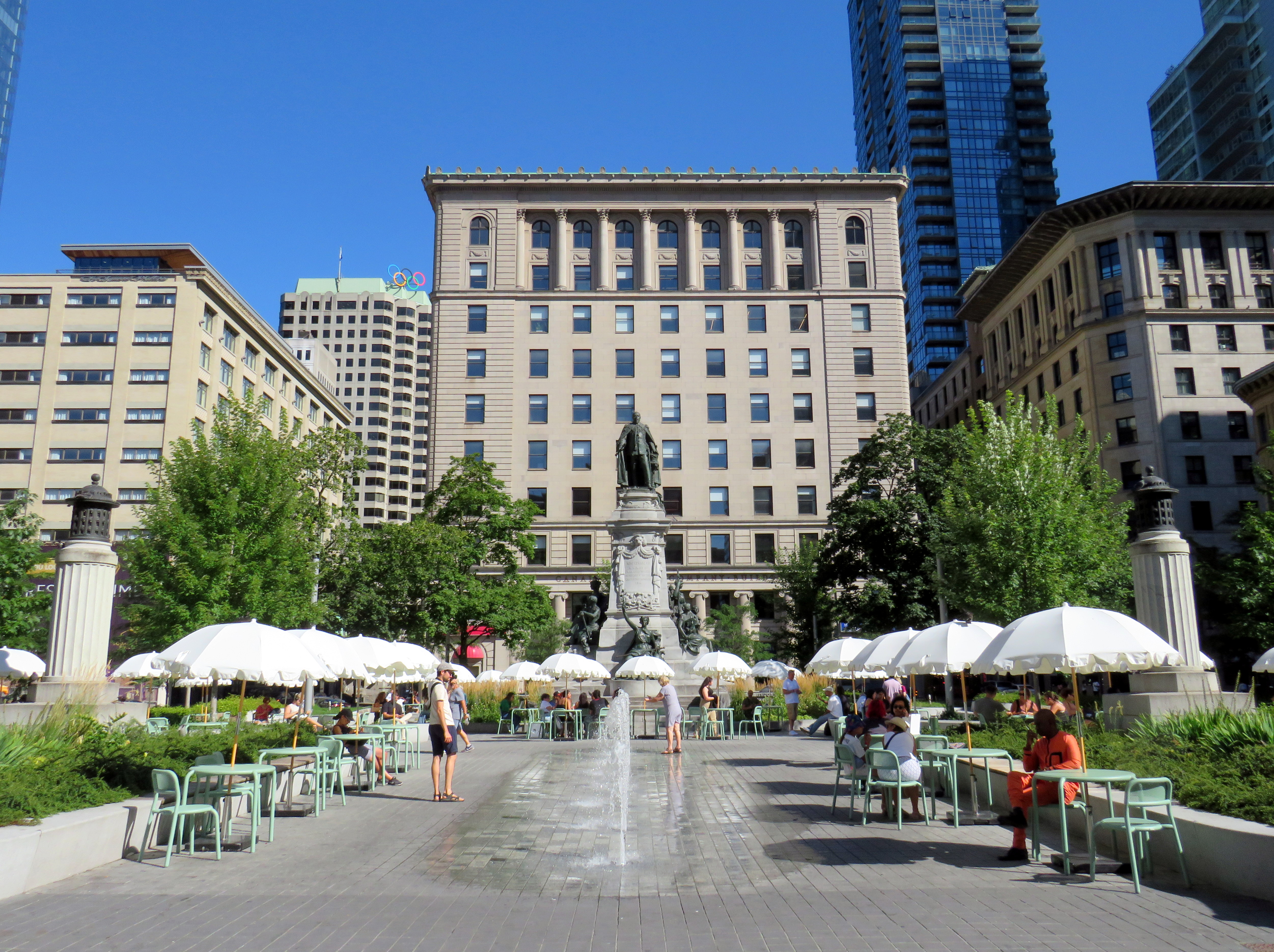
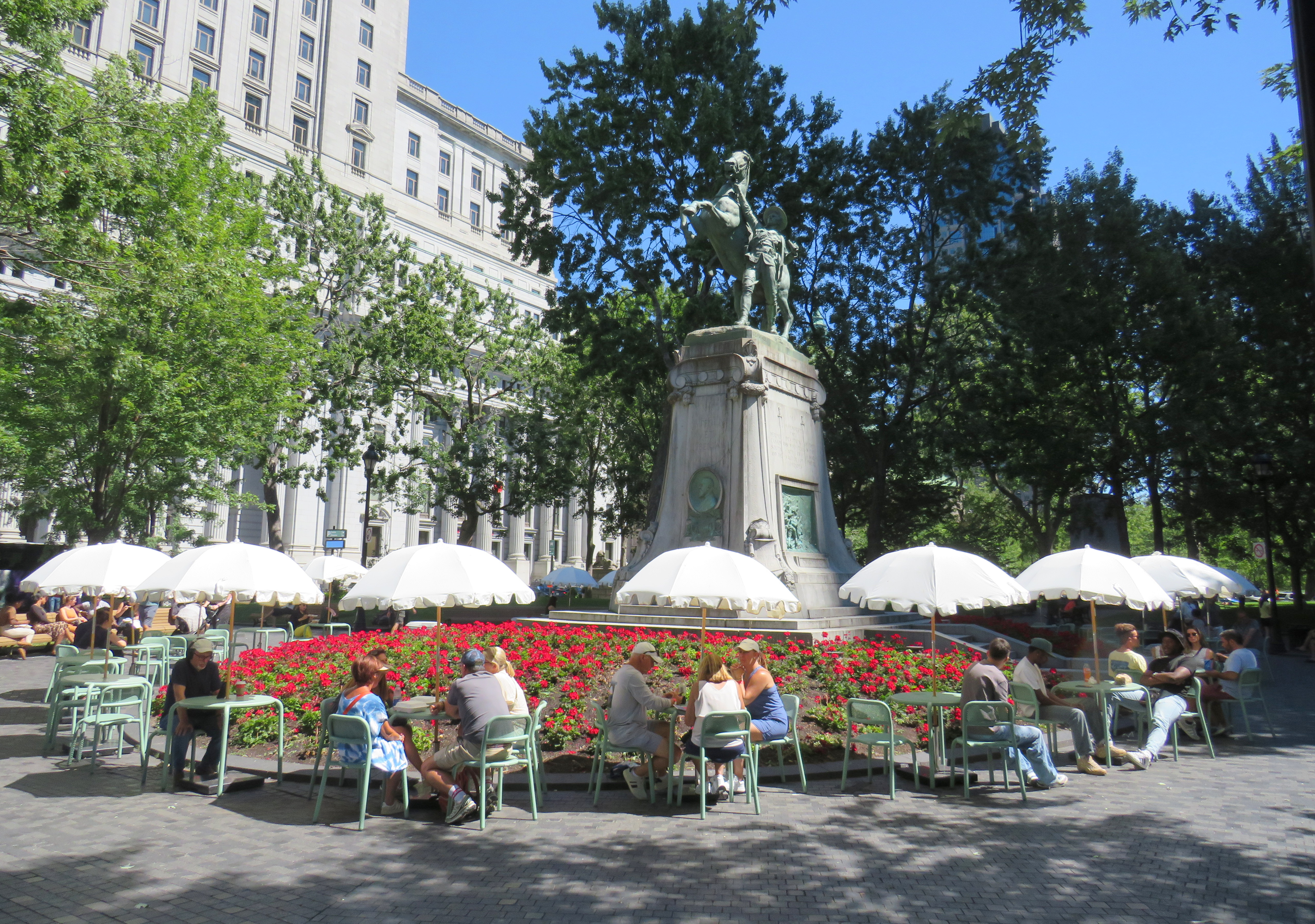
Several public squares were also renewed in recent years. Phillips Square, on Rue Ste-Catharine across from the now-shuttered Hudson’s Bay department store, was renewed with new splash fountains along with small café-style tables and chairs, complete with shade umbrellas. The metal chairs are movable, allowing larger groups to sit around a single table. It’s a refreshed natural congregation point along the city’s main shopping street.
Phillips Square, August 2025
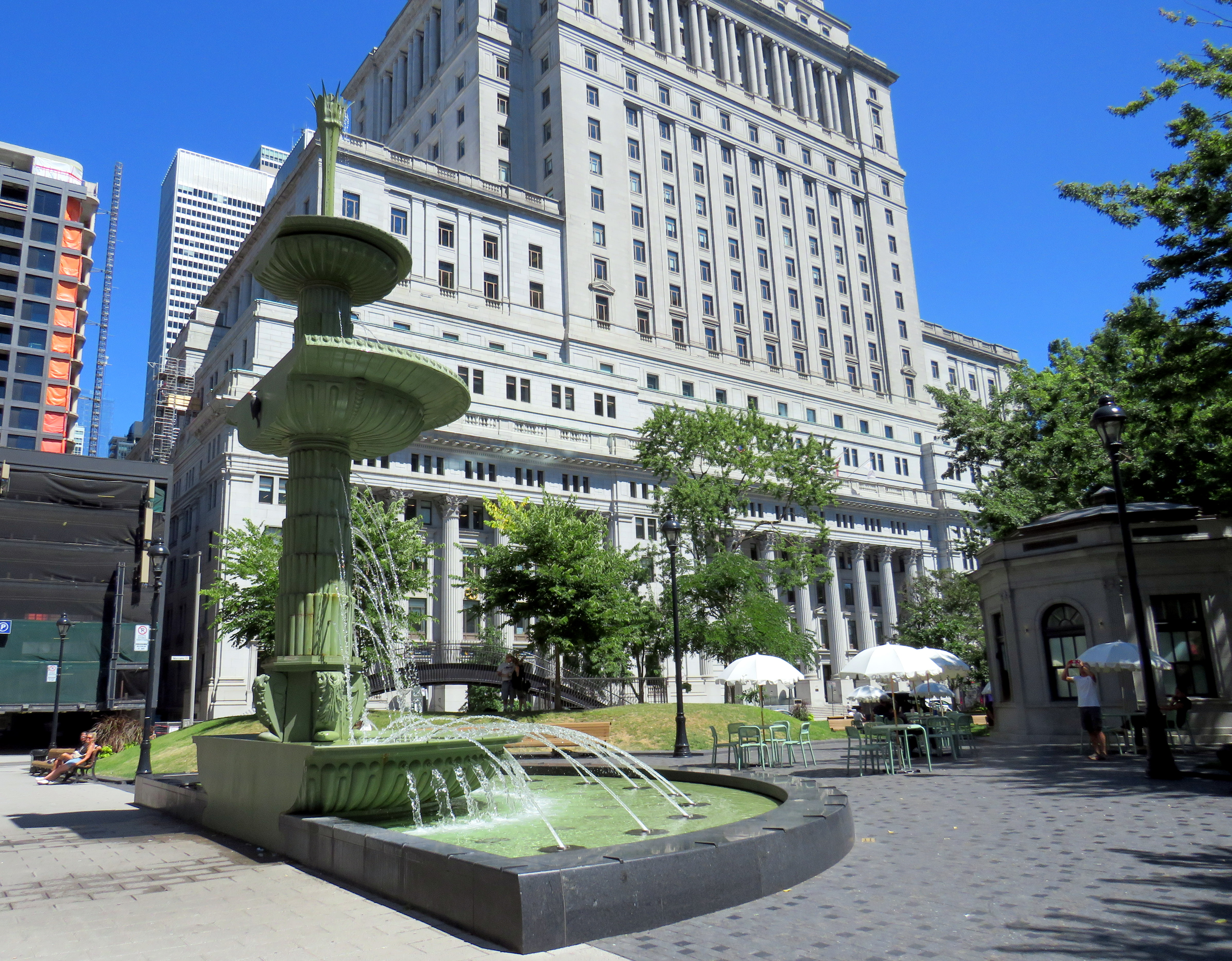
Similar tables and umbrellas were set up at Dorchester Square, several blocks to the west, near Mary, Queen of the World Cathedral and Central Station. Both squares were reimagined by the brilliant landscape architecture firm Claude Cormier + Associés. At Dorchester Square, a new water fountain, seemingly a classic installation, is cut in the rear, with a woodpecker behind. Such Easter eggs are features of Cormier park projects.
Dorchester Square, August 2025Fountain at Dorchester Square; note the woodpecker on the side. One of the two black curved footbridges across the parking ramps is behind.
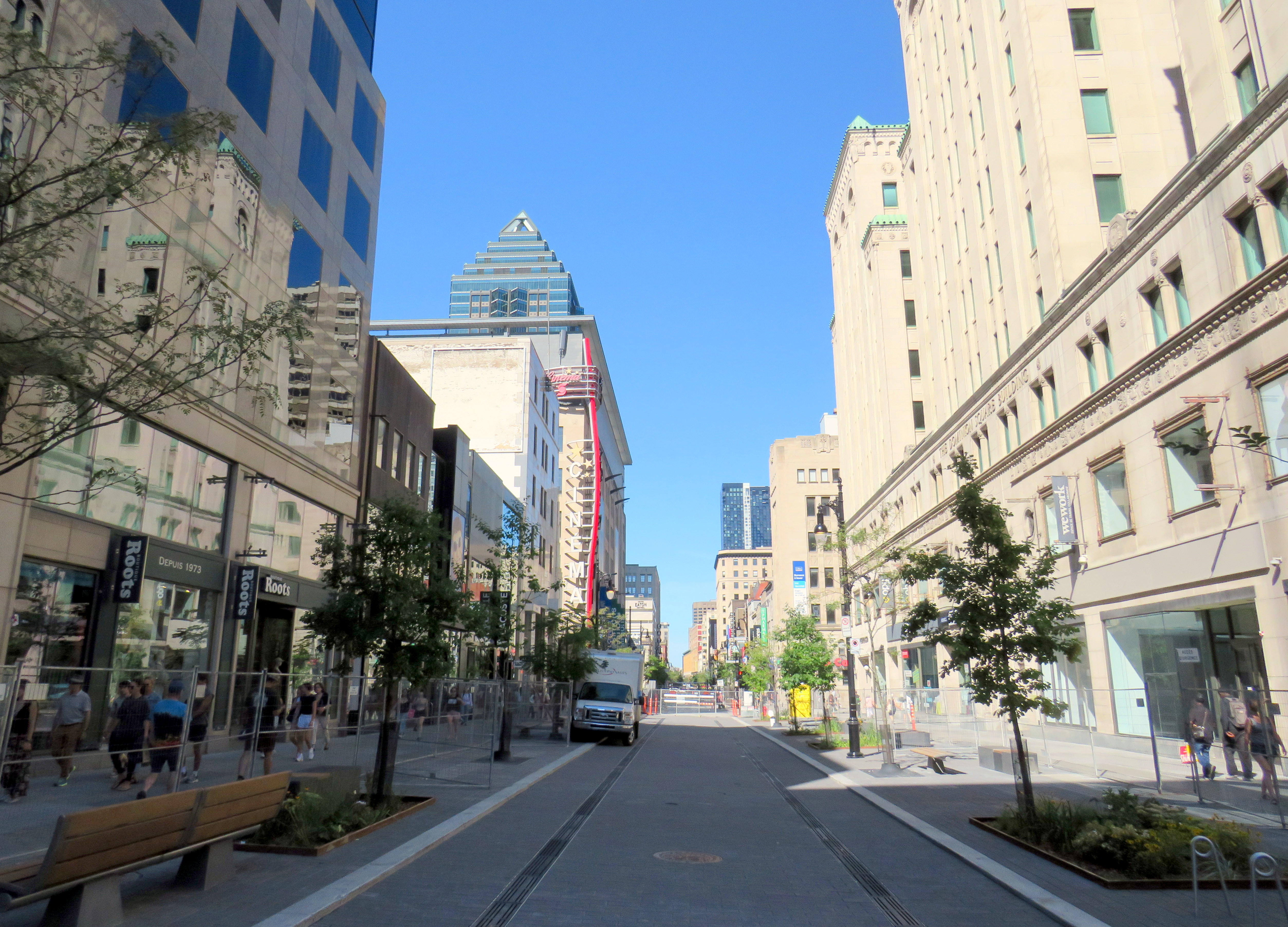
Furthermore, Montreal is rebuilding the western section of Rue St-Catharine towards Crescent. Though motor vehicles are permitted after reconstruction, they are limited to a single through lane, with lay-bys for deliveries, passenger pick-ups and drop-offs, and emergency vehicles. Sidewalks are widened considerably, with more benches, bicycle parking, and street trees.
Completing Rue St-Catharine, near Bishop Street
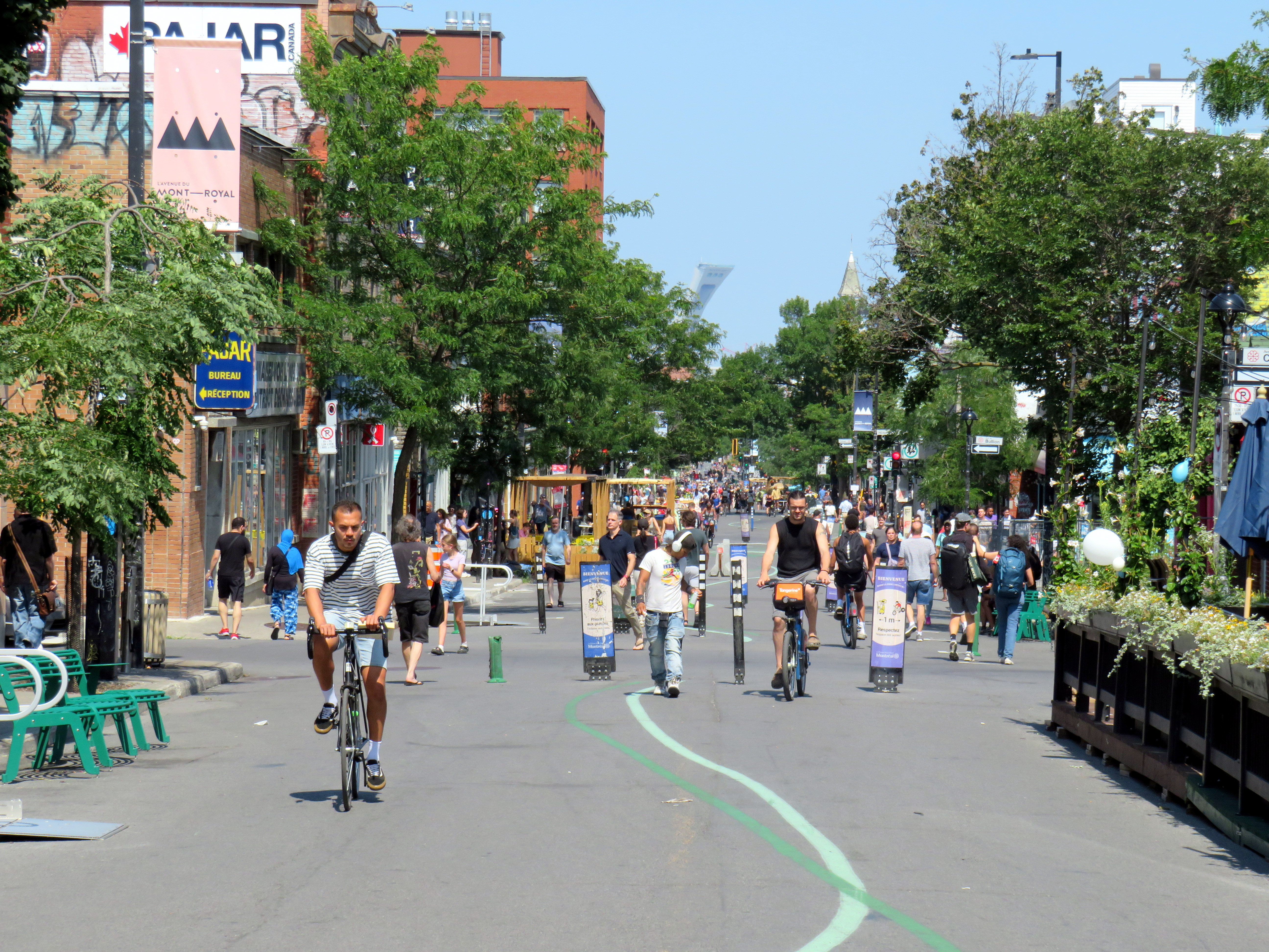
After returning to Toronto, it’s easy to feel down on this city. Montreal seems to do everything right. Meanwhile, ActiveTO, the open streets initiative following the pandemic restrictions here, quickly eroded, and was effectively ended in 2022. Open Streets, which closed sections of Yonge and Bloor Streets to motorists for two Sunday mornings, was last held in 2022. But there are still business improvement area-led weekend street festivals, which attract tens of thousands of pedestrians.
Torontonians want to walk, and pedestrianized streets, even when they’re just weekend events, are immensely popular. One downside, however, is a lack of seating outside of businesses’ patio areas. One is free to walk, enjoy live music, or just people watch, but to sit down, one is compelled to purchase something from one of the businesses with a sanctioned patio.
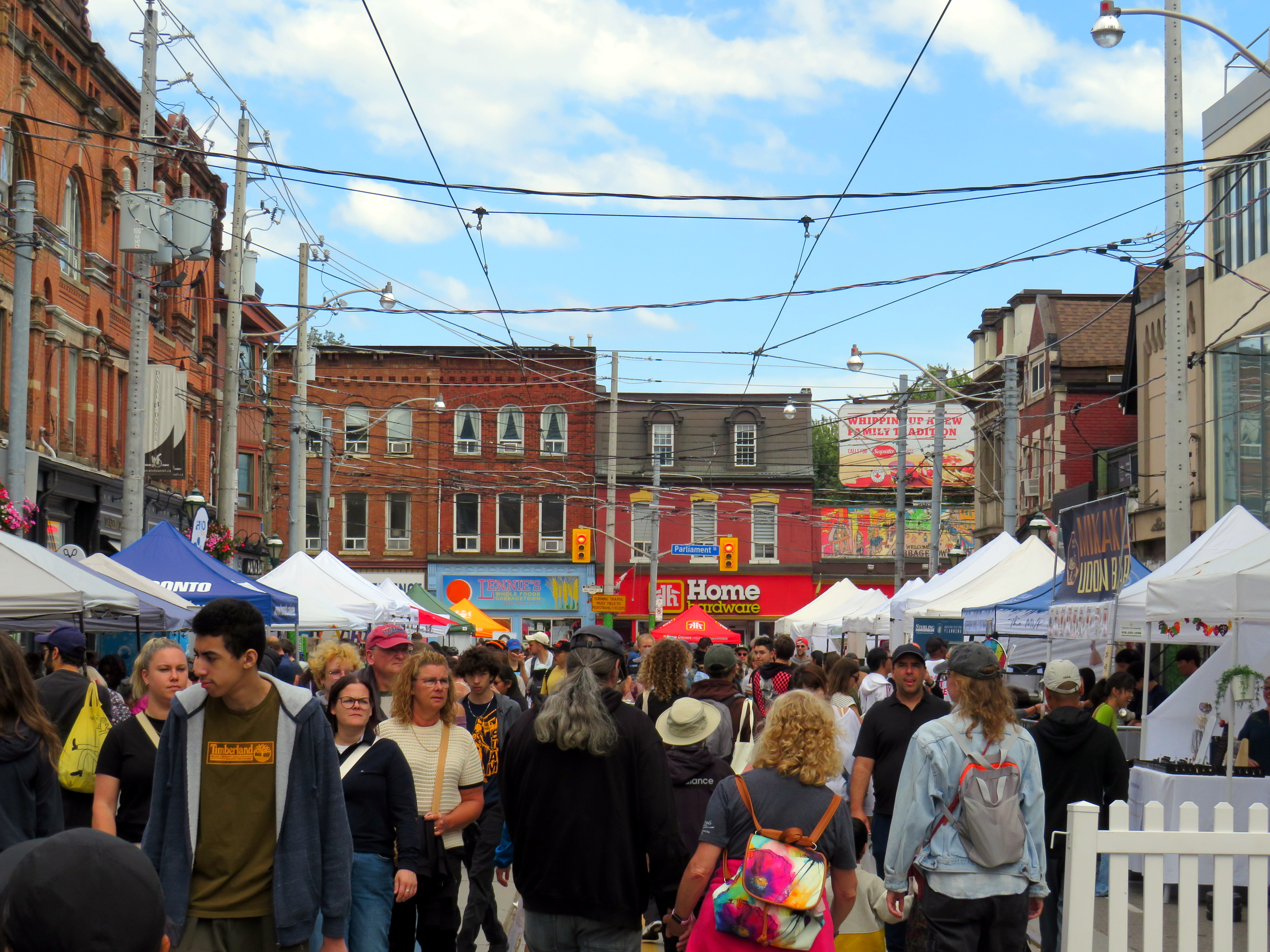
Torontonians love a street festival: Cabbagetown in September
There are a few other successes. A small segment Gould Street at Toronto Metropolitan University was pedestrianized and rebuilt as a central plaza for that university campus. A short section of Willcocks Street at the University of Toronto was similarly pedestrianized.
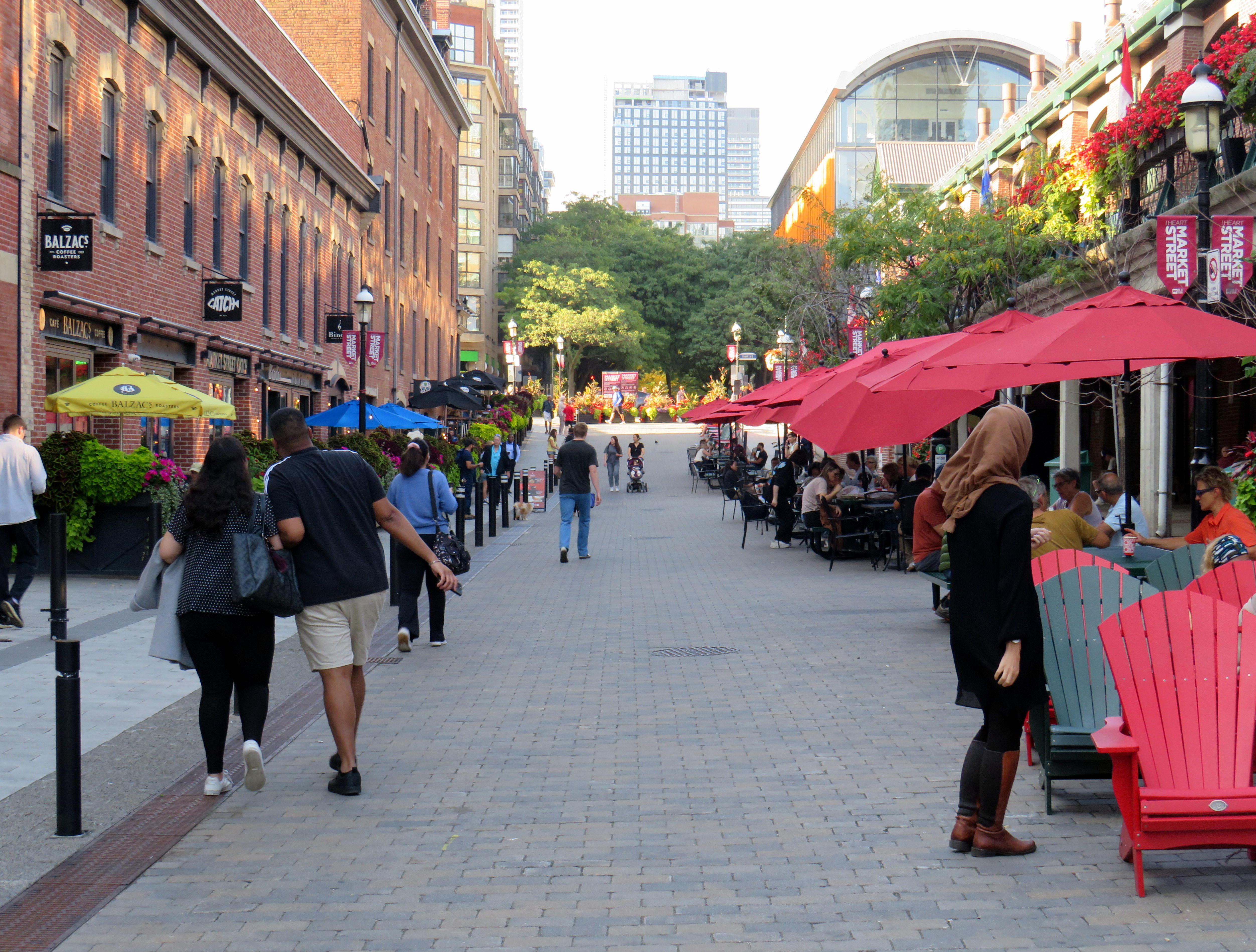
But the best example in Toronto is Market Street, which abuts St. Lawrence Market. Patio space and Muskoka chairs provide plenty of seating, without obligation to purchase anything (though it provides additional seating to those who picked up a snack or lunch inside the market). The shade umbrellas and high-quality surface materials and street furniture make this a wonderful oasis in Toronto’s downtown core.
Market Street looking north from The Esplanade. St. Lawrence Market is on the right.
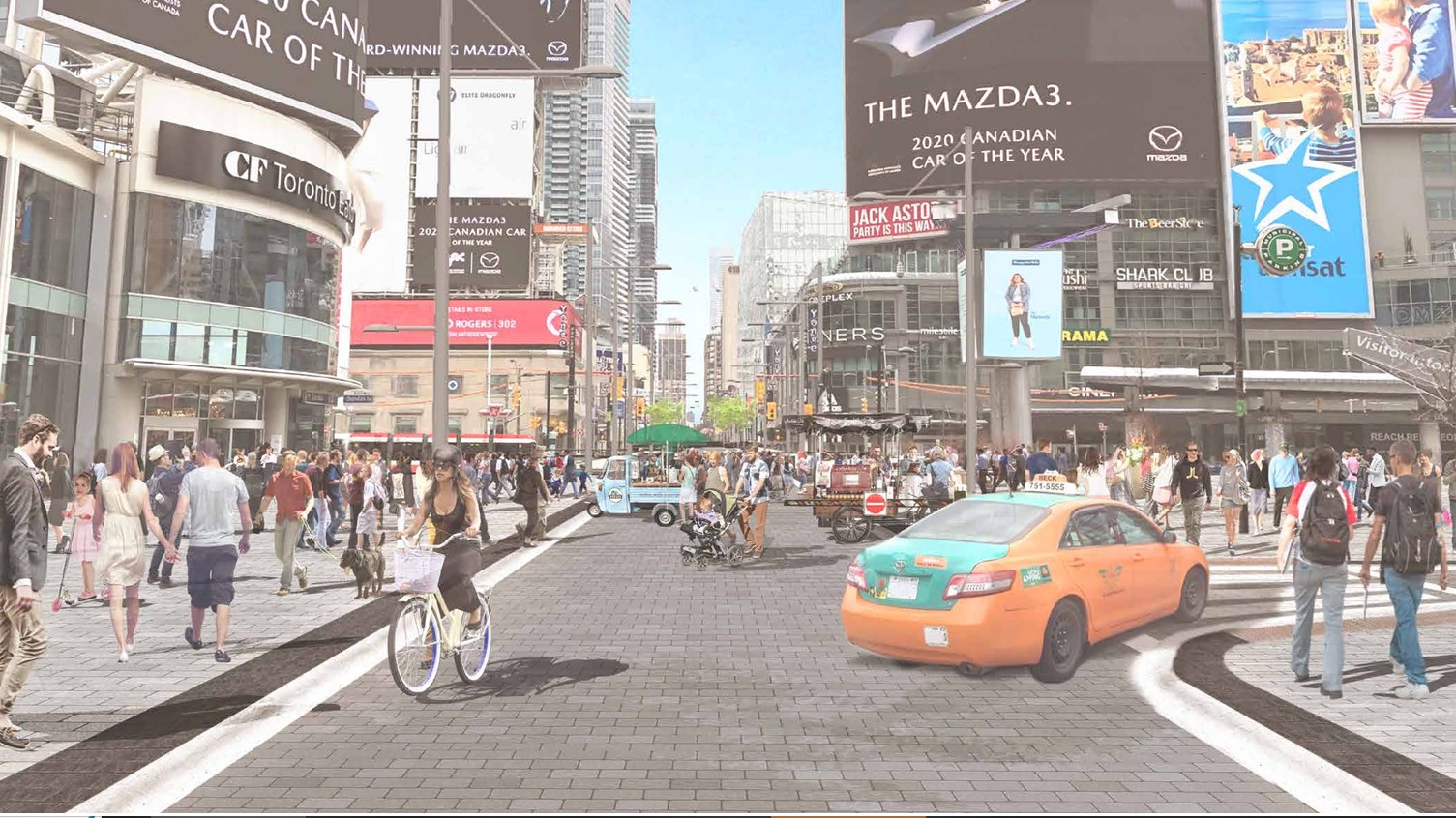
Planning for Yonge Street’s makeover, which will include narrowing the roadway, widening the sidewalks, improvements to the public realm, and seasonal closures of selected sections of the traffic lanes, is complete. Unfortunately, the YongeTOmorrow improvements will have to wait for another five years (work starting in 2030) due to Ontario Line construction.
Rendering of Yonge Street looking north towards Dundas, once YongeTOmorrow improvements are complete
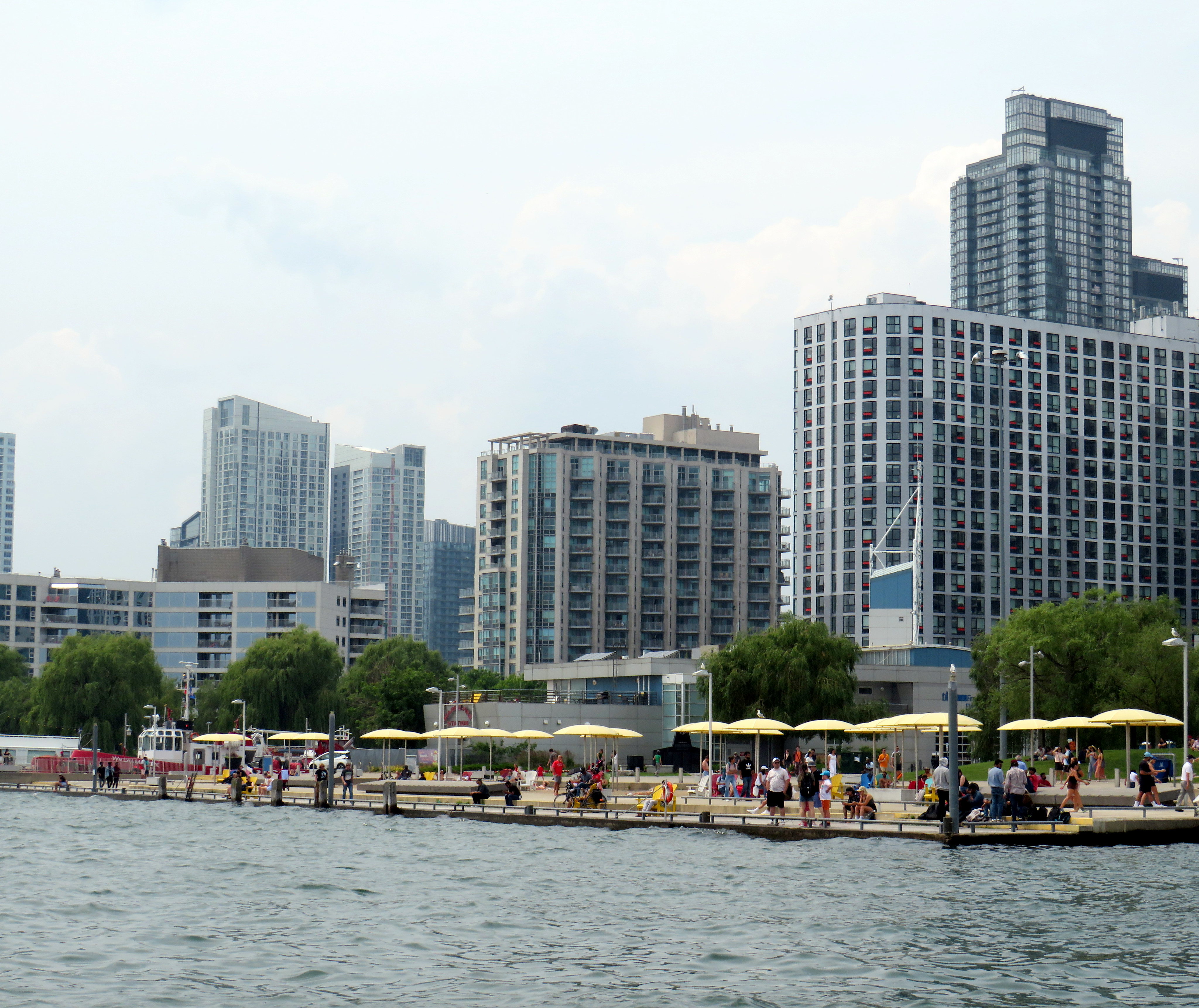
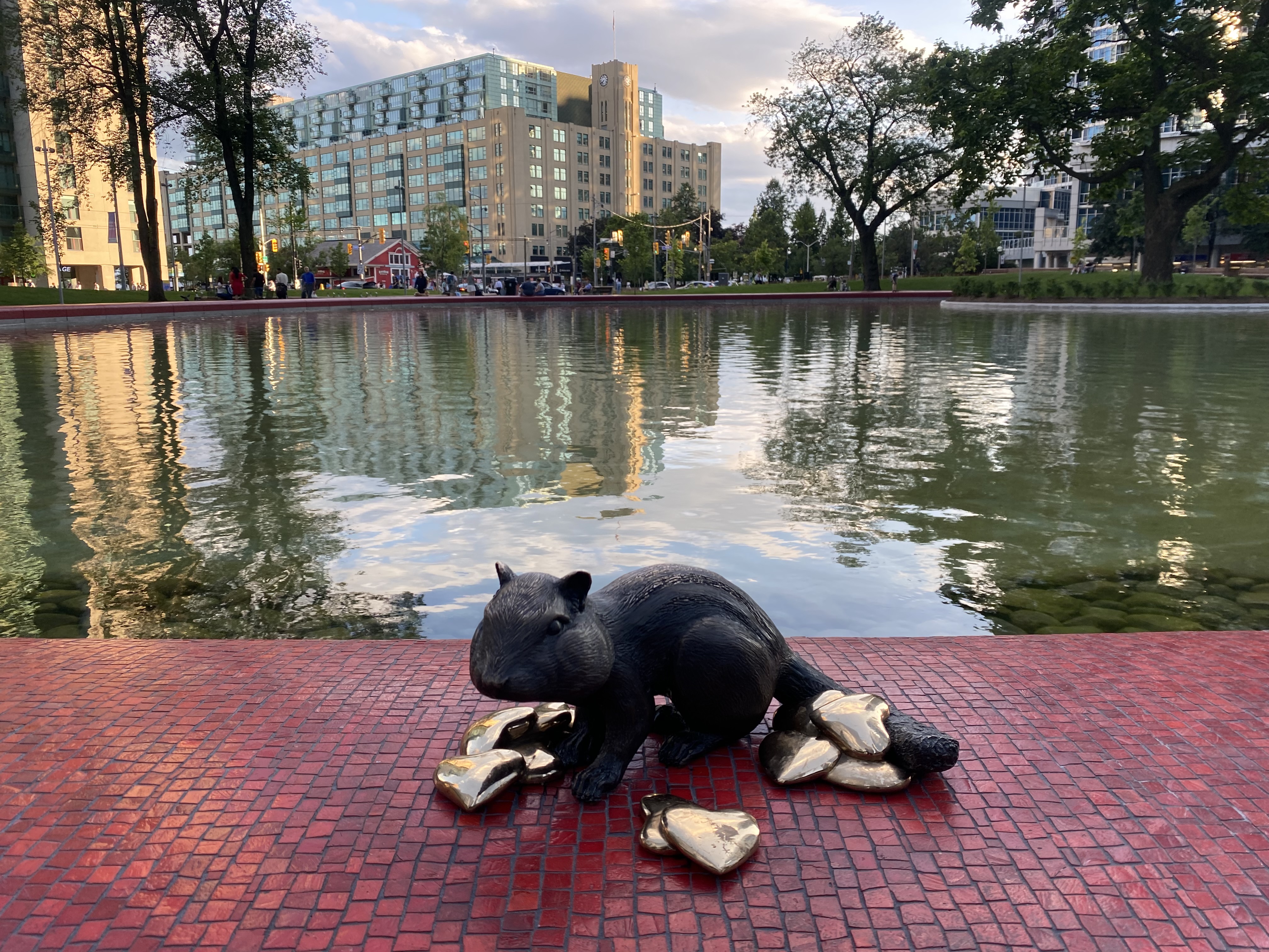
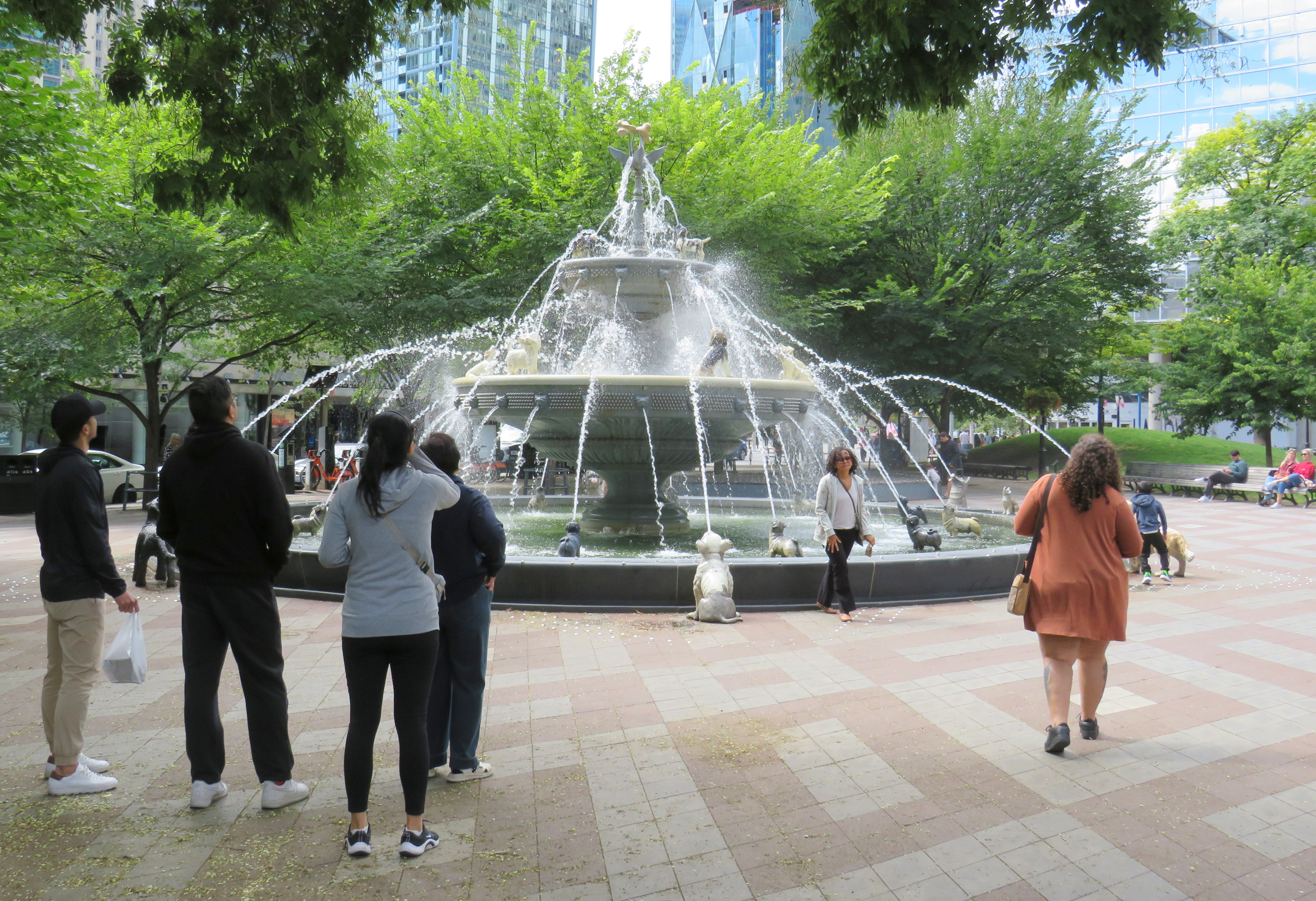
There are also other great things happening in Toronto. Claude Cormier was tapped to create new public spaces, such as HtO Park and Sugar Beach on the Harbourfront, but also reimagine existing places such as Love Park (previously a highway off-ramp) and Berczy Park, home of the popular Dog Fountain. At Love Park, not one of the 45 movable chairs have been taken (though one ended up in the pond). Torontonians have been shown to cherish great public spaces.
HTO Park from Toronto Harbour
Canada’s Sugar Beach
Love Park
Berczy Park
Toronto has made a lot of progress on improving its public realm, and it has shown that it is willing and able to close streets to traffic for the benefit of pedestrians and cyclists. Though it is so very easy to envy Montreal for its greater progress in the last two decades, it is up to us to continue the momentum Toronto does have, and work harder to push for change, even when there’s a car-focused provincial government. Streets can be narrowed, parks can be improved, and streets can be handed over to the people. Additional seating and more public washrooms will open up this city to many more residents and visitors.
This should all be a key pillar of a progressive agenda in next years’ municipal election. When certain candidates talk about tax cuts, austerity, and crime, there needs to be a focus on creating a better quality of life to provide an alternative. And that talk must be backed up with action, with quick wins that don’t require multi-year waits.