Category: Toronto

  • The jarring streetscape of Jarvis Street

    The jarring streetscape of Jarvis Street

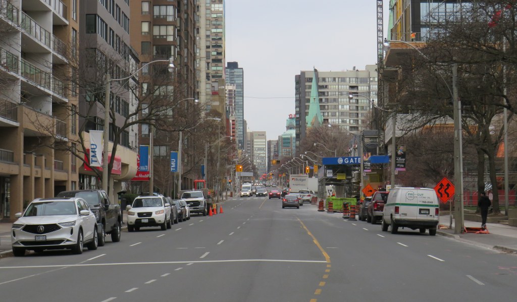
    Curb lanes closed for condominium construction have defeated the purpose of Jarvis Street’s fifth reversible lane

    Over a century ago, Jarvis Street was Toronto’s most fashionable address, and home to prominent families including the Masseys, who made their wealth from the farm equipment industry, and whose names live on through Massey Hall, Hart House, the Fred Victor Mission, and Massey College. The wide boulevards allowed for lush street trees to flourish, and without streetcars, there was no need for a wide roadway, despite the generous right-of-way.
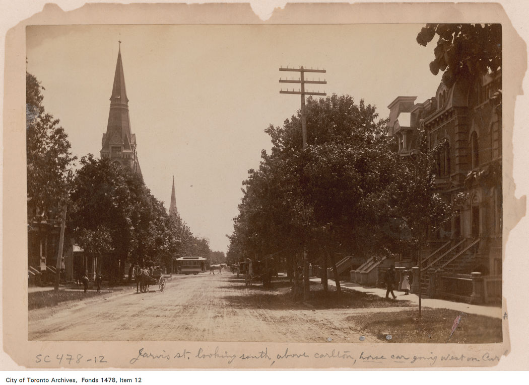
    Jarvis Street looking south towards Carlton Street in the 1880s. City of Toronto Archives: Fonds 1478, Item 12.

    By the 1920s, though, Jarvis was no longer fashionable, with Forest Hill, North Rosedale, and Moore Park taking its place. Many of the old mansions fell into disrepair or were converted into apartments or businesses. The street became lined with low-rise apartment buildings, budget hotels, and missions to the poor and unhoused. After the Second World War, the city government decided to extend Mount Pleasant Road south of St. Clair Avenue to Bloor and Jarvis Streets and widen Jarvis Street to accommodate the increased traffic. Along with building the Dundas Street East extension, widening Dufferin Street, and pushing through Eastern Avenue, the City of Toronto was bending to the whims of the automobile, several years before the creation of Metropolitan Toronto in 1954.
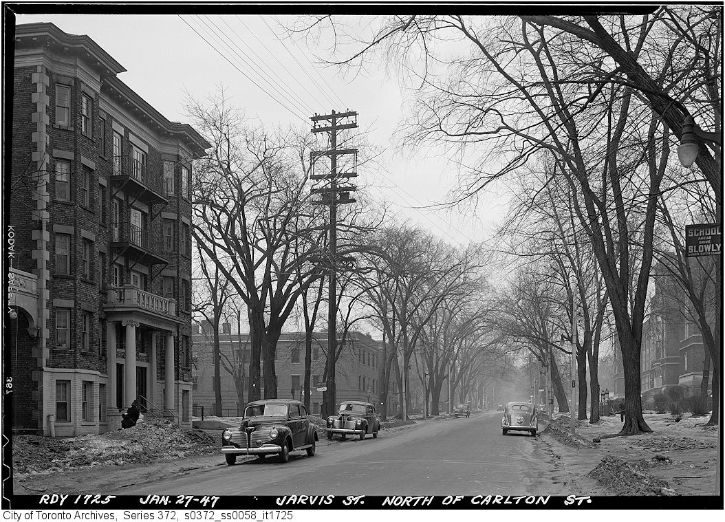
    Jarvis Street looking north from Carlton Street, January 1947, just before the street trees were removed and the street widened. City of Toronto Archives, Series 372, Item 1725.

    By the 1960s, Jarvis Street became the preferred address of federal institutions such as the Moss Park Armoury, the regional Unemployment Insurance offices at Dundas Street, and the brutalist Ontario headquarters for the RCMP. The provincial government expanded the old Juvenile Court with a new modernist building, and Simpsons-Sears, the predecessor of Sears Canada, built a new imposing office building at 222 Jarvis, adjacent to the Simpsons warehouse on Mutual Street.
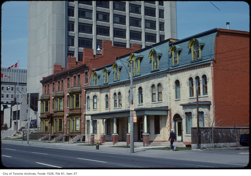
    Victorian rowhouses stand next to the brutalist RCMP building on Jarvis Street, north of Shuter Street in 1979. The RCMP building later became the home of the Grand Hotel, which installed a glass veneer over the imposing west façade. The Unemployment Insurance office, at the corner of Dundas Street appears in the far left. Both the RCMP/Grand Hotel and the UIC (later Hilton Garden Inn) building were recently demolished, but the rowhouses still stand.
    Photo by Harvey R. Naylor. City of Toronto Archives, Fonds 1526, File 61, Item 27.

    Jarvis Street was also the home of several of the CBC’s scattered radio and television studio spaces until they were consolidated at the CBC Broadcasting Centre on Front Street, and it was also the location of the first Four Seasons Hotel, when it started out as a chic motor hotel.
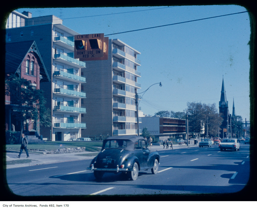
    Jarvis Street looking south from north of Carlton Street; the Four Seasons Motor Hotel at 415 Jarvis Street and St. Andrew’s Lutheran Church are visible in the background. Note the centre lane indicator above. Creator: Skinner, Dorothea Skinner. City of Toronto Archives Fonds 492, Item 170.

    By the early 1960s, Jarvis Street was reconfigured further to include a new reversible centre lane between Queen Street and Mount Pleasant Road at Charles Street. Then, as now, the centre lane was designated for southbound traffic, except during weekday afternoon rush hour, when the flow is reversed. Parking is prohibited at all times on the east side of the street, while on the west side, street parking is permitted except during the morning and afternoon peak periods. This, at least in theory, allows for two lanes of unobstructed traffic in both directions at all times, and in the rush hours, three lanes of peak-direction traffic. This, of course, depended on strict enforcement of parking and stopping prohibitions, and the lack of construction or other obstructions.

    As Jarvis Street rebounded and new residential development and commercial development began to line the street between the mid-1980s and the present day, the five-lane traffic arterial layout became less suitable. In 2009, City of Toronto staff recommended, with extensive public input, that it was desirable to remove the reversible centre lane, narrow the roadway, and widen the sidewalk on the east side of the street to improve the public realm and address the needs of the thousands of new residents who were moving into the east end of Downtown Toronto. The additional space would have allowed for tree planters and wayfinding signage that would highlight the street’s history. Studies conducted by city staff found that there was no need for the fifth lane to provide adequate traffic movement along the street.

    Cyclists, however, were unhappy that the road redesign did not include cycling lanes and they were able to convince council to alter its plans. As a result, in 2010, the road was not reconstructed, but the reversible lane was removed, with new painted cycle lanes on both sides of the street.

    When Toronto elected Rob Ford as mayor that October, he promised an end to “the war on the car,” even inviting now-disgraced hockey commentator Don Cherry to give the inaugural speech, which turned out to be a controversial rant against “pinko cyclists” and “left wing kooks.” In 2011, with the support of suburban councillors, Rob Ford reversed the decision to install bike lanes on Jarvis Street (along with Pharmacy Avenue and Birchmount Road in Scarborough), and the reversible lane was re-installed.

    Ironically, the demand by cyclists for bike lanes made it easy to restore the auto-oriented configuration, while widened sidewalks would have been much more difficult to remove.
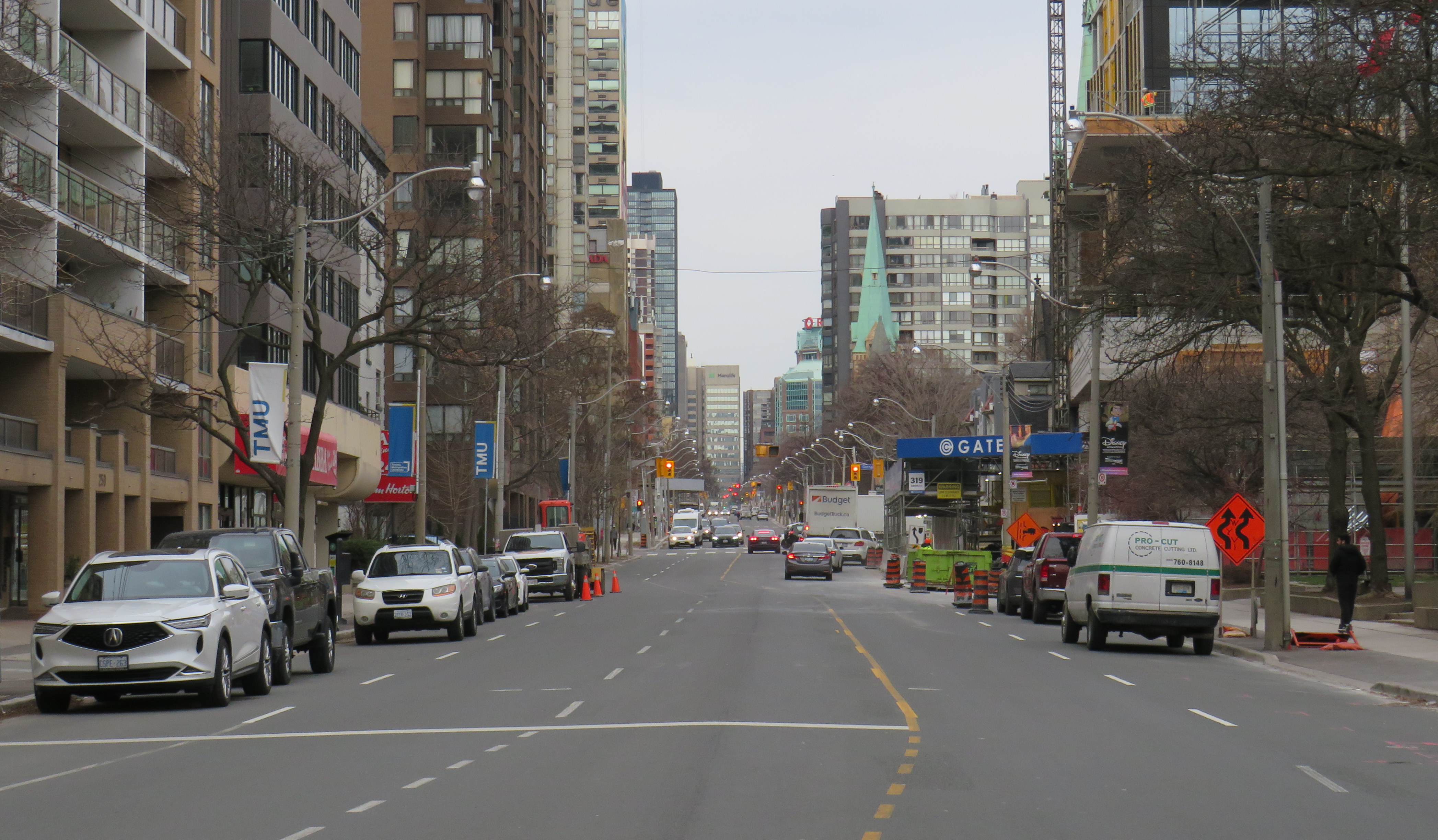
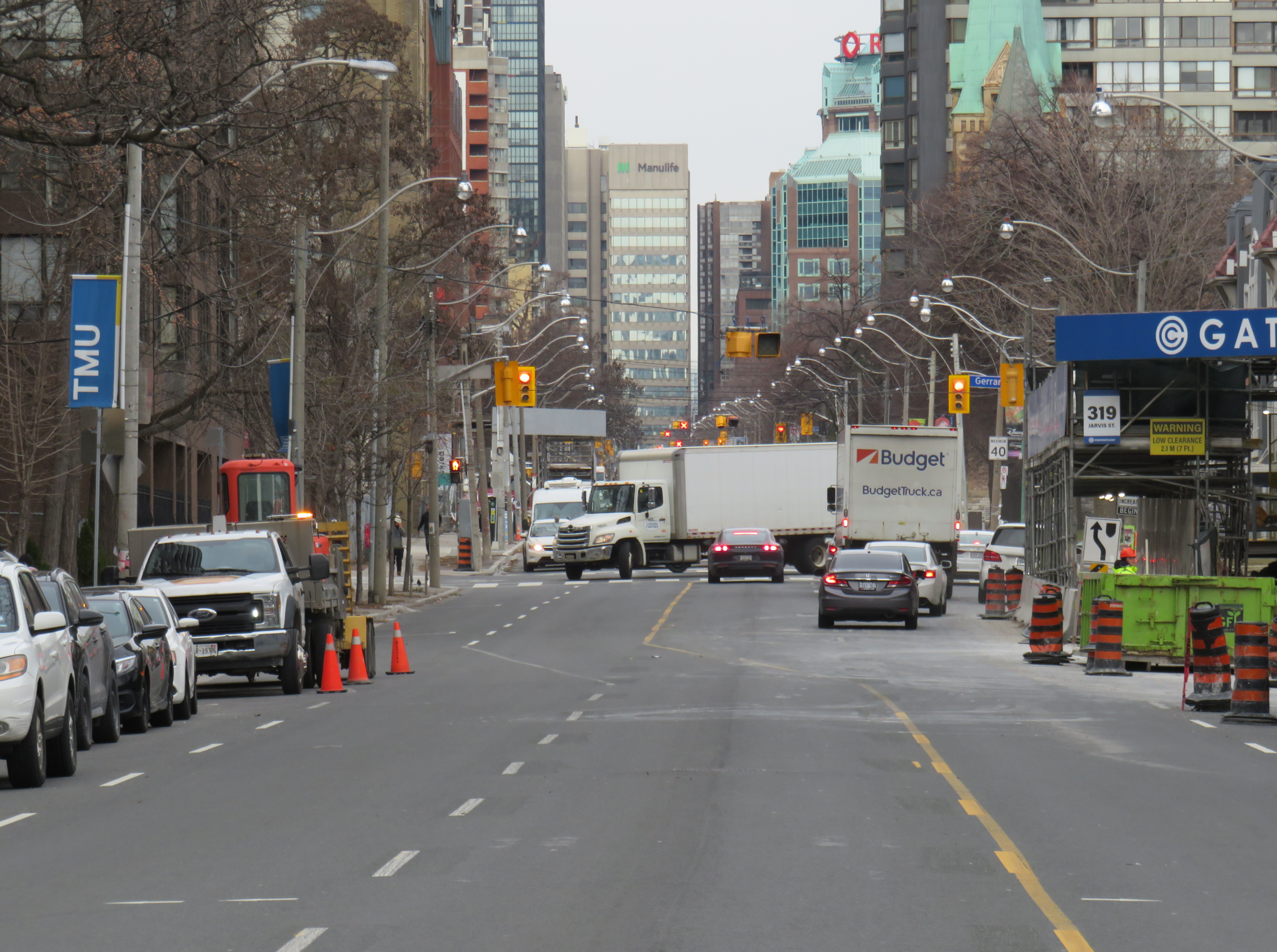
    Between Dundas and Gerrard Street, the lanes shift to accommodate a lane closure for a new condominium tower on the east side of Jarvis Street.

    With much needed watermain and road reconstruction in the last few years, the traffic advantage provided by the reversible lane was negated because of the construction barriers. Several condominium towers being constructed along the street, at Carlton, Gerrard, and Shuter Streets, have further affected the ability of that fifth lane to move motorists quickly, effectively, or safely. Between Dundas and Gerrard Streets, the lanes temporarily shift for a long-term lane closure on the east side, just south of Gerrard. This lane shift adds additional confusion to an already confusing road layout.
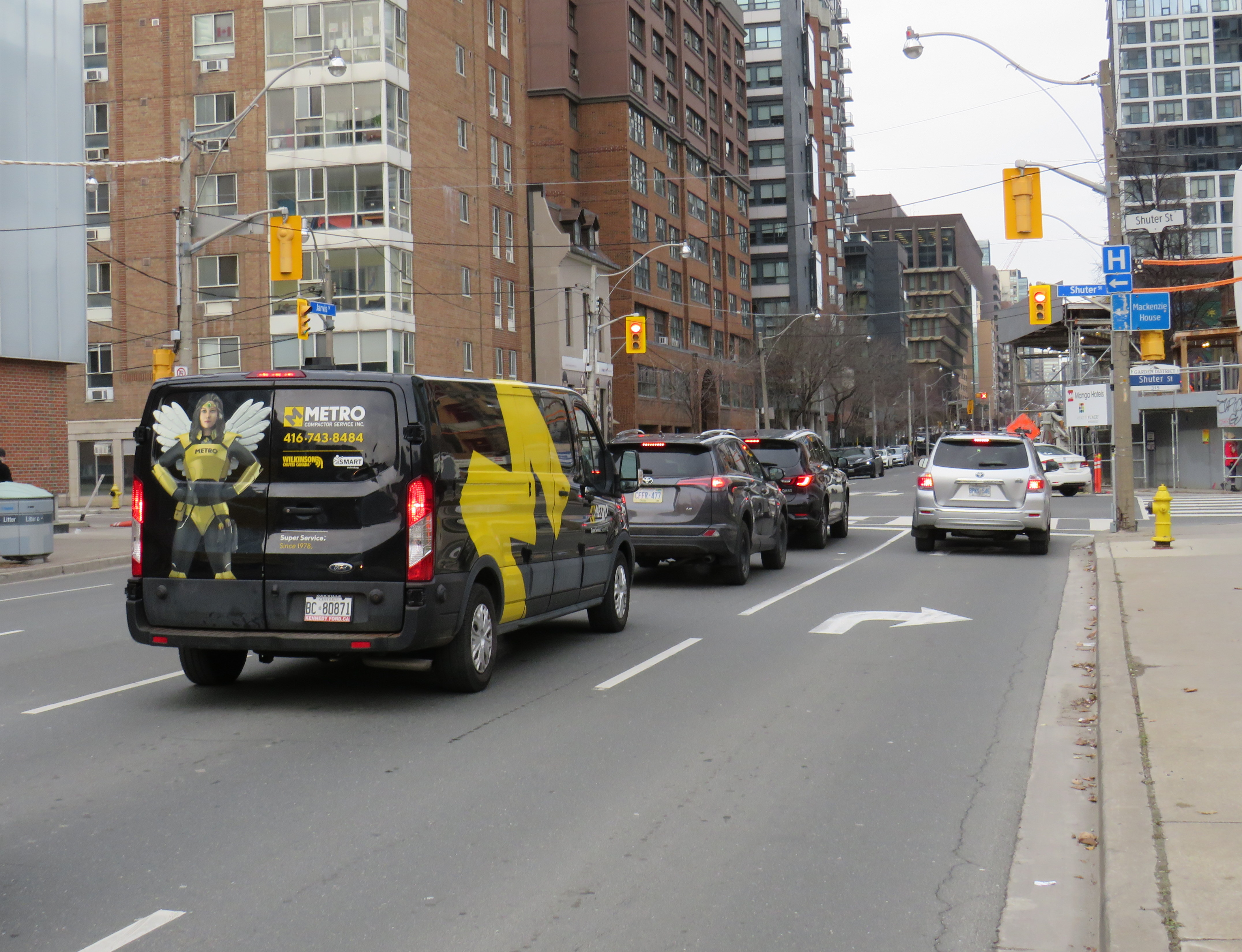
    Looking north to Shuter Street, with the curb lane temporarily marked for right turns only.

    At Shuter Street, the construction of the Hyatt Place hotel and condominium apartment development has seen the northbound curb lane closed for several years. Approaching Shuter, the curb lane is marked as a right-turn lane, but it is used as an illegal bypass of traffic waiting at the light or turning left onto Shuter towards St. Michael’s Hospital and the Eaton Centre. This, combined with the hidden sightlines caused by the construction hoarding on the northeast corner, makes it especially dangerous for southbound motorists as well as pedestrians and cyclists crossing at this point. Beyond the construction hoarding, the right lane is used for construction crew parking, as well as staging for vehicles such as cement trucks.
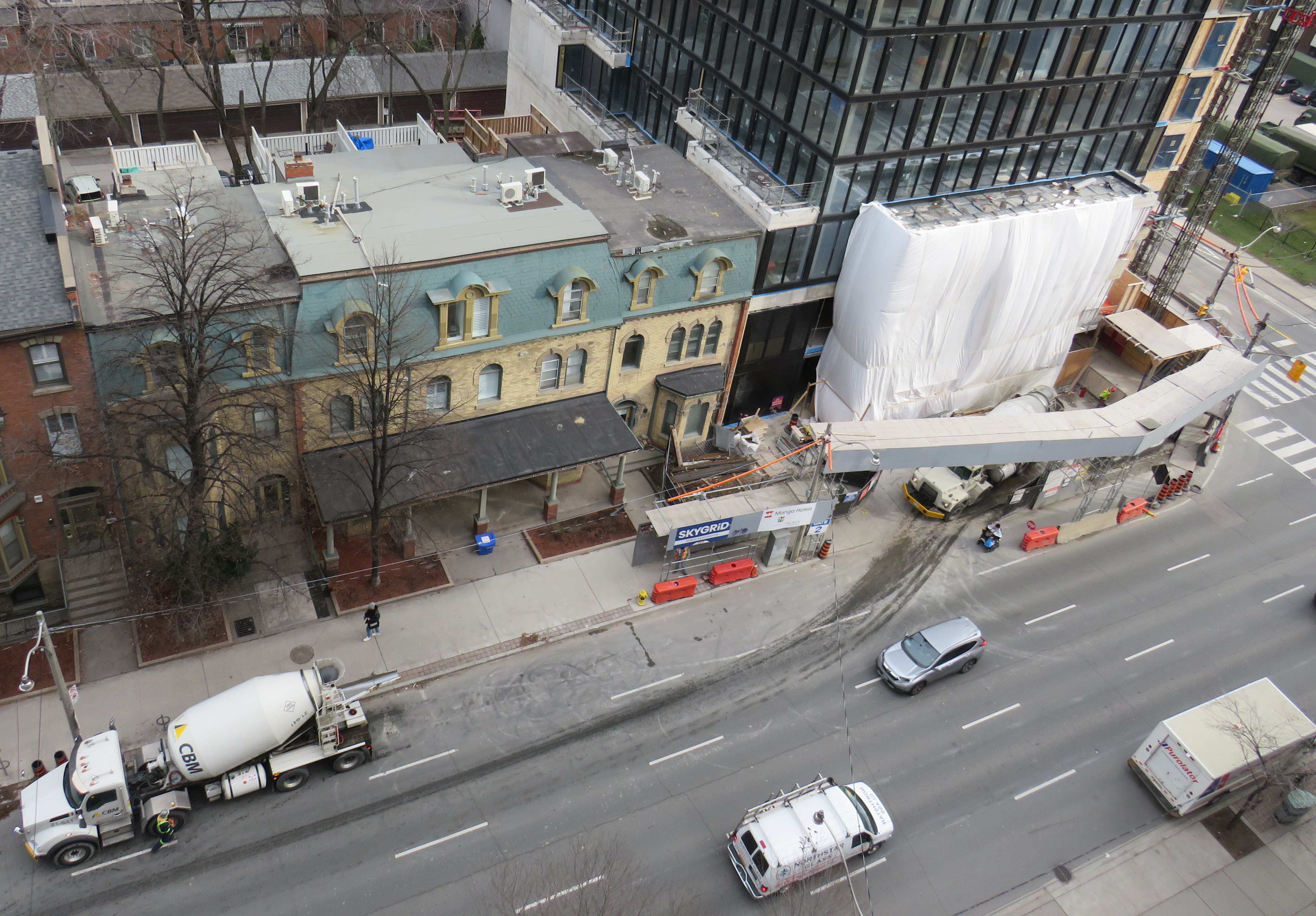
    Looking down towards the Hyatt Place development, showing the obstructed northbound curb lane, as well as a grey SUV crossing into the centre lane, which was reserved for opposing traffic when this photo was taken.

    The long-term closure of lanes on Jarvis Street should make it clear to city officials that the outdated and unsafe middle lane is of no practical use, and it finally has got to go.

    At Jarvis and Shuter Streets, the northbound right turn lane is used by impatient motorists, including a City of Toronto garbage truck, a taxi cab, and the driver of a speeding Lincoln Navigator.

    Collisions are common on Jarvis Street because of the reversible centre lane — which exists nowhere else in Toronto, and in only a few places elsewhere in Canada — because of driver confusion, impatience, negligence and incompetence. As Jarvis Street becomes home to thousands of more residents in the next few years, is beyond time that the street becomes safer and more attractive to live, work, and enjoy life on.

  • Mapping the results of the 2022 Toronto municipal election

    How Toronto voted for mayor. Areas shaded in blue represent electoral subdivisions (polls) where John Tory placed first. Areas shaded in purple represent polls where Gil Penalosa placed first. Click here for the interactive version.
    As has become my tradition after Toronto’s municipal elections, I mapped out the poll-by-poll results of the mayoral race and some of the more interesting council races. After creating maps for the 2014 election and sharing those on social media, it was suggested that I have a website to host these maps. That is how this website came to be.

    This time, I created an interactive map showing the results of the mayoral race, along with six council races: Ward 3 Etobicoke-Lakeshore, Ward 4 Parkdale High-Park, Ward 5 York South-Weston, Ward 11 University-Rosedale, Ward 18 Willowdale, and Ward 20 Scarborough Southwest.

    I offer more thoughts over at Spacing Toronto, as part of a series mapping the municipal election.

  • Mapping the 2022 municipal election

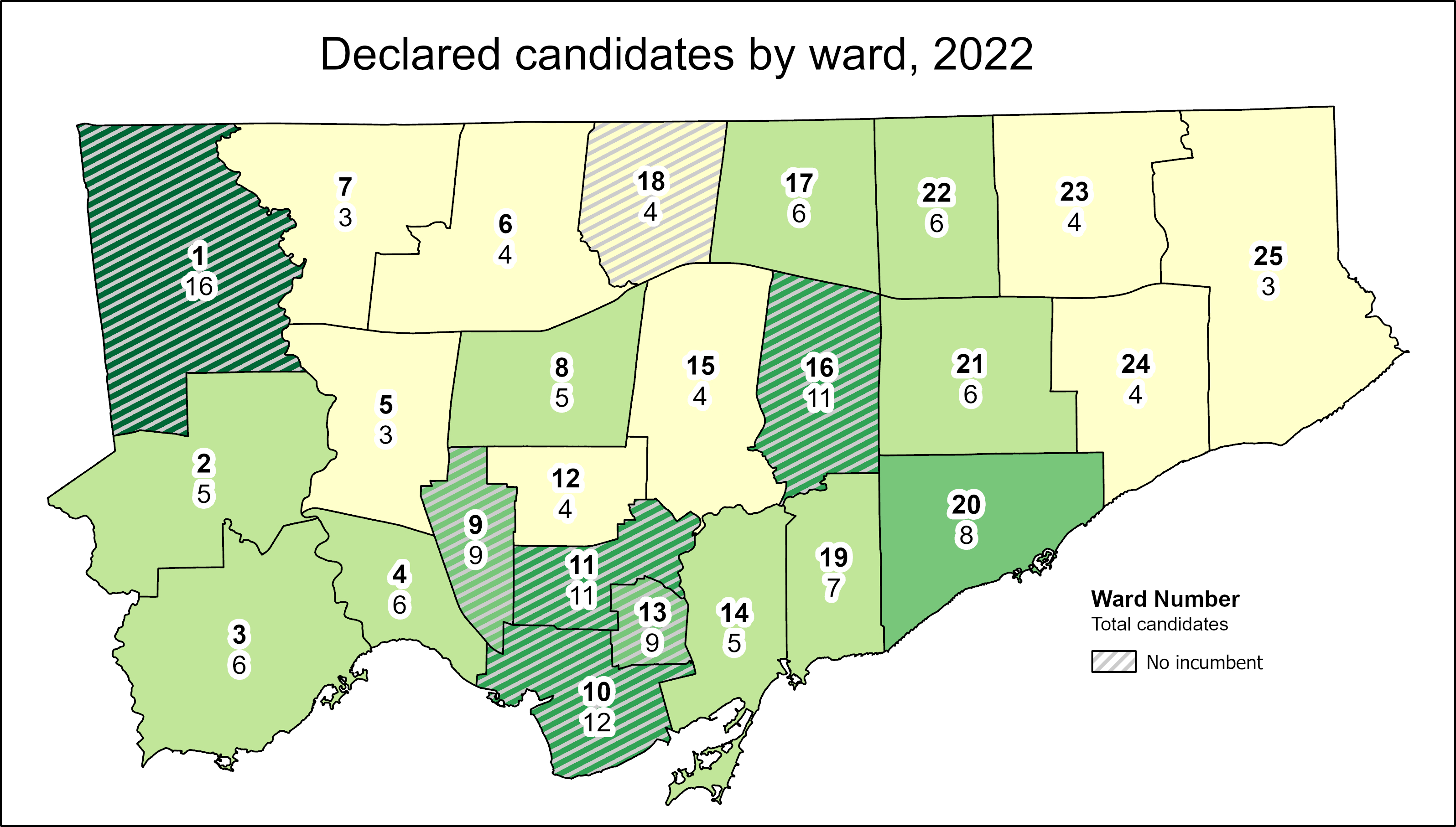
    Number of candidates running in each ward

    This coming Monday, October 24, Ontarians will be electing new city councils. In Brampton, Ottawa, and Hamilton, the mayoral races should prove to be interesting. For Ottawa in particular, with Jim Watson stepping down, voters have a clear choice (and I’ll be cheering for Catherine McKenney). Though Gil Penalosa offers a new vision of a sustainable, active, and safer city, it’s very likely John Tory will win an unprecedented third term, the first to do so since amalgamation in 1998.

    At Spacing Toronto, I have been offering some insights by mapping the state of our local democracy, ward by ward. Though there are seven wards in which no sitting councillor is running for re-election, the new council may not look too much different from the last one. That’s because two former councillors — Vincent Crisanti and Jon Burnside — will be looking to get back into office. Meanwhile, Mayor Tory has been busy campaigning for twelve candidates, including eight incumbents, that will help advance his agenda of incrementalism and austerity. Among Tory’s picks are Frances Nunziata, who has been in municipal office uninterrupted since 1988.

    Here are the links to my posts at Spacing:

    Open wards and the power of incumbency: The power of incumbency, and the mayor’s own influence, will weigh heavy on the final results. Though there may be seven “open” wards and a few more truly-competitive races, there is a lot happening behind the scenes to favour certain candidates.

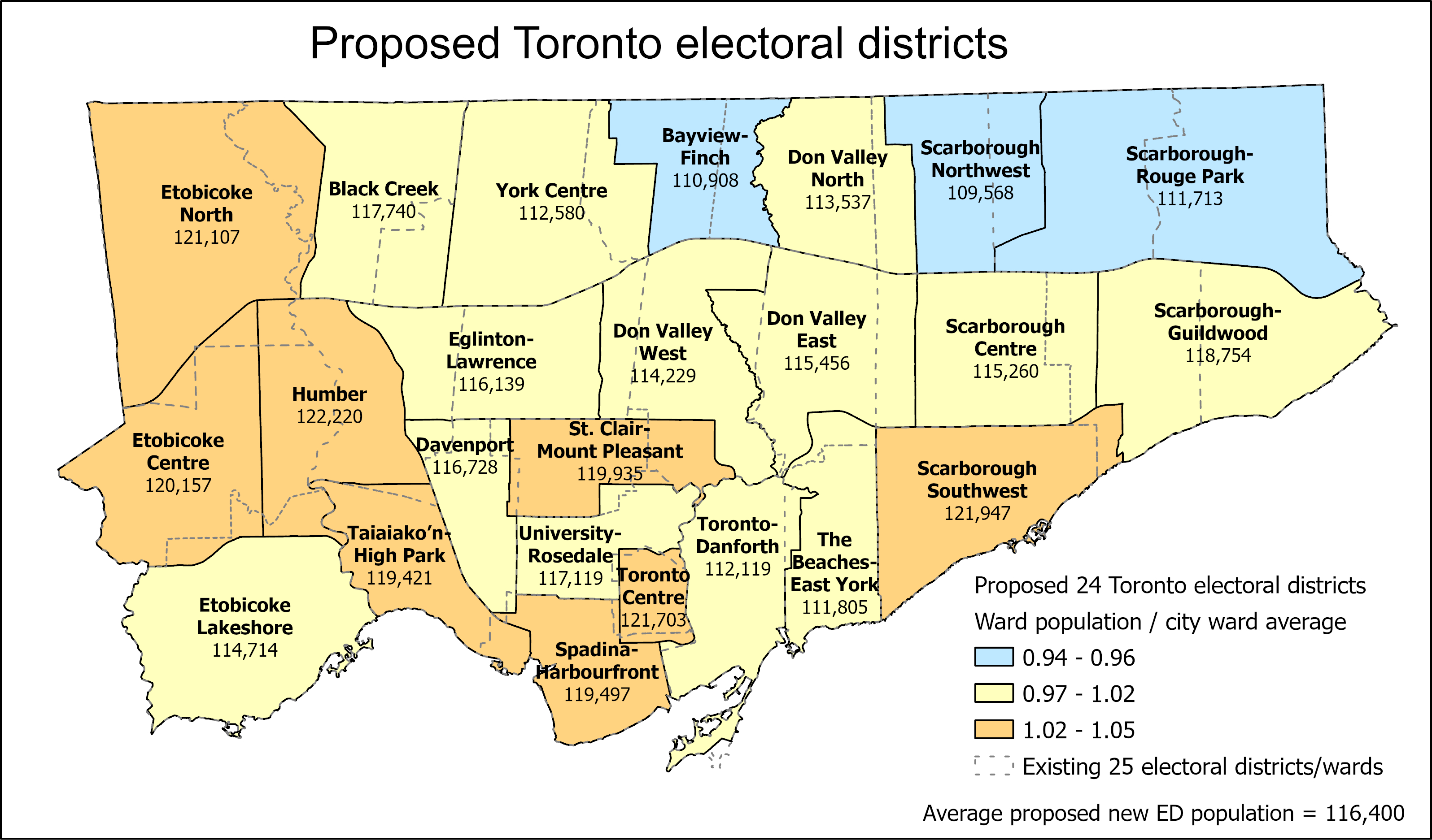
    Population disparities between Toronto’s 25 wards: How ward boundaries that were drawn in 2013 have exasperated imbalances in population, leading to burnout in high-growth wards (with several downtown councillors deciding to move on). If Toronto continues to be forced to use federal/provincial riding boundaries, it will have just 24 wards in the 2026 election.

    What Toronto’s new ward boundaries might look like

    Toronto is a highrise, rental city – unlike City Council: Though nearly half of all Torontonians live in highrise dwellings and/or rent their homes, Toronto City Council is made up almost entirely of homeowners. In only a few wards, detached houses make up the vast majority of the housing stock and homeowners dominate. I ask why city council doesn’t reflect the way an increasing number of us live. The interest in this post had me on CBC Metro Morning for the first time, early on September 30.

    Duelling campaign endorsements: Though Mayor John Tory has supported a few candidates before (most notably, Etobicoke councillor Mark Grimes), this time, he’s actively campaigning with twelve allies. Meanwhile Progress Toronto is backing nine challengers, focusing on races where it hopes to help get new faces elected.

  • GO Transit is broken – and other transit updates

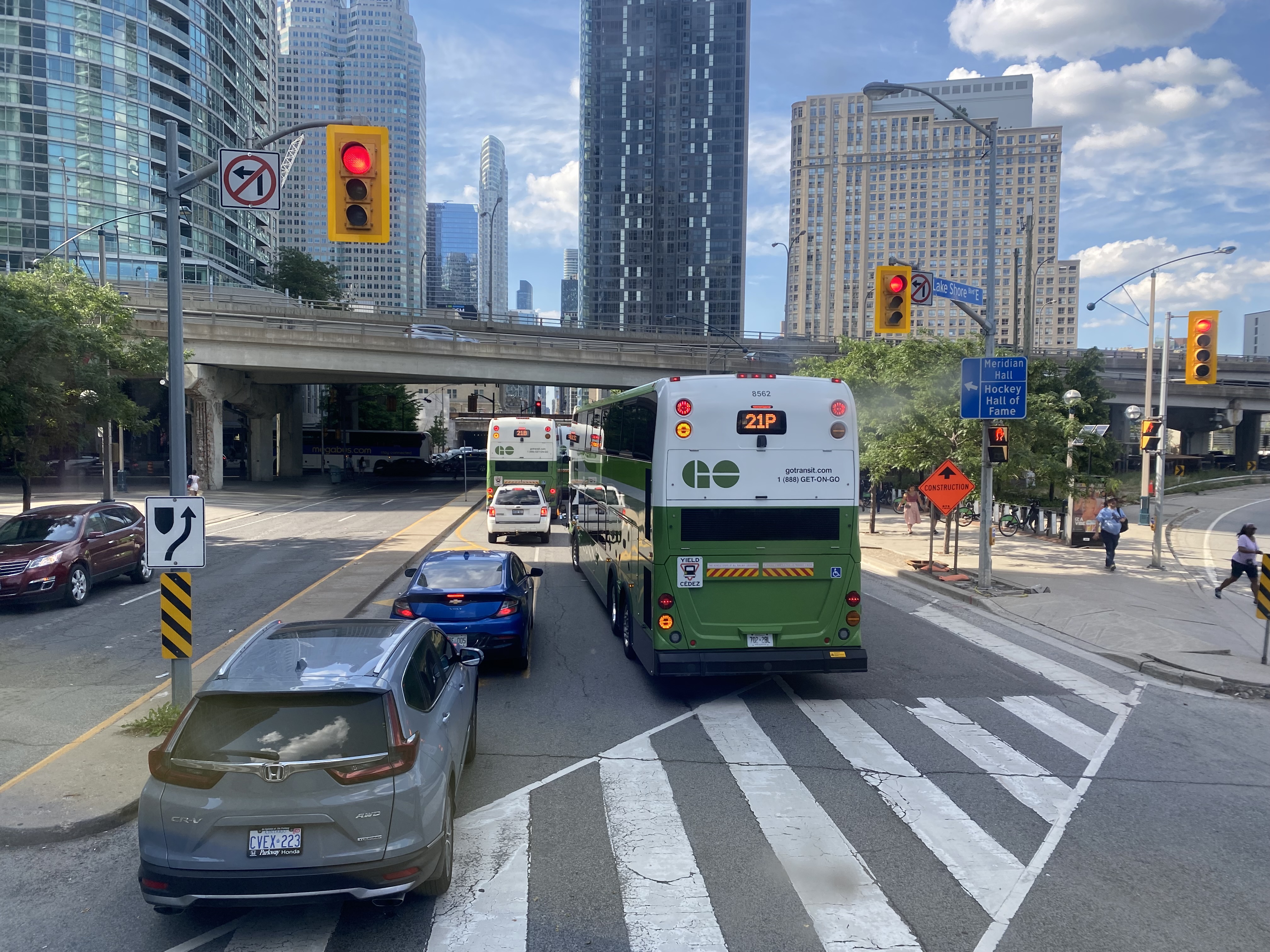
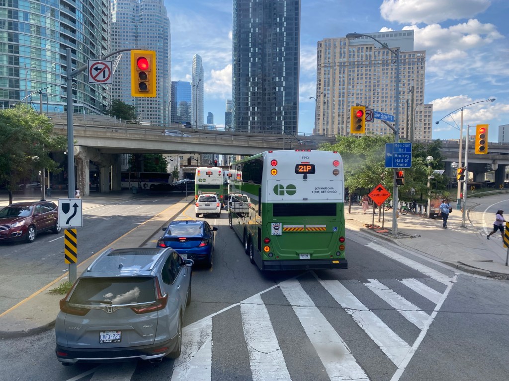
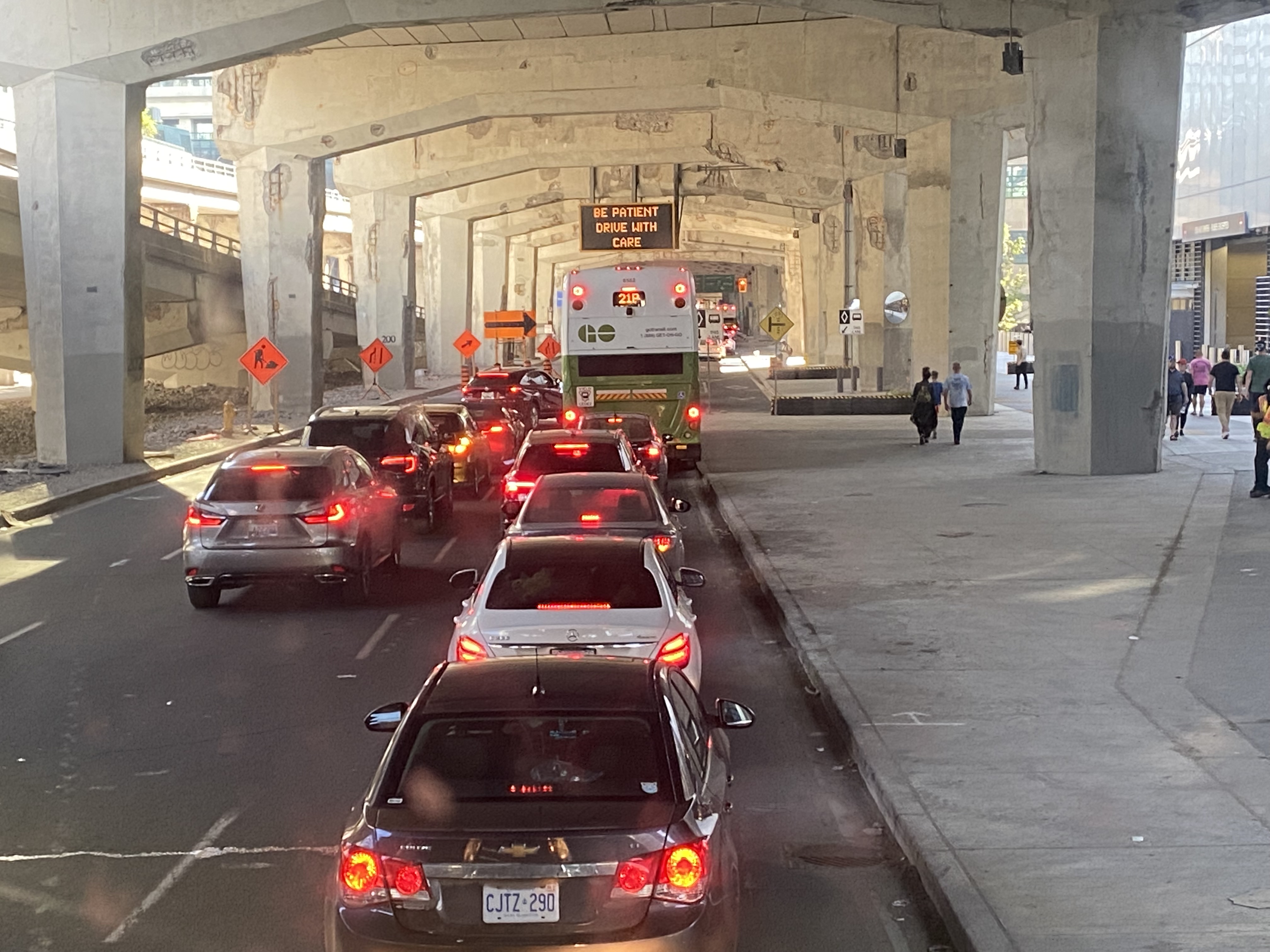
    GO Transit buses stuck in Downtown Toronto gridlock in July, 2022

    While travelling through the Northeastern United States this spring and summer, I found myself feeling lucky to be living in Toronto. Though the New York City Subway and the PATH trains between New Jersey and Manhattan were operating pretty much as I remember them, in other big cities, the mass transit systems were in rough shape. In Washington, underfunding and incompetence led to the long-term withdrawal of over half of its Metro cars. During our visit in April, we were treated to long waits and crowded trains, though at least the system was clean. When we visited Philadelphia in late June, it was clear that the Southeastern Pennsylvania Transit Authority (SEPTA) had given up: poor communications, lengthy waits, unsafe subway stations, and general apathy among staff and passengers made my spouse and I resort to driving on our last day there.

    In Toronto, at least, the subway was still running frequently (with only minor service cuts due to the pandemic), the buses and streetcars as (un)reliable as ever, and despite more anti-social behaviour on some of its surface routes, I almost never felt afraid for my well-being when riding the Rocket, compared to my experience in Philly. GO Transit responded to the pandemic very well. Though it was forced to suspend many of its train and bus trips due to a sudden plunge in ridership, it maintained a basic service level on nearly all of its routes, slowly restoring certain services in 2021 as ridership slowly rebounded. Some corridors, like the Kitchener Line, had more service in the early Fall of 2021 than it did prior to the pandemic. As Metrolinx continued planning and construction of major transit projects like GO Expansion, the Ontario Line, and several LRT corridors, the future looked bright. In Spring 2022, GO Transit introduced a special weekend day pass for $10 per day or $15 per weekend, to help grow ridership.

    Unfortunately by late June 2022, GO began to fall apart.

    (more…)
  • Deadly by design: Warden and Comstock

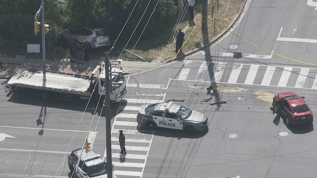
    On Thursday, July 21, 2022, at 3:10 PM, a 38-year-old man was standing at a street corner in Scarborough, waiting for a signal to safely cross to the other side. Before he even had the chance to enter the intersection of Warden Avenue at Comstock Road, a driver of a 2009 silver Kia minivan heading south on Warden struck a 2012 red Lexus, whose driver was making a left turn from Warden to Comstock.

    Aerial view of the collision, courtesy of CTV News. The Kia minivan struck a 38-year-old man waiting at the corner before plowing into a fence protecting a vacant lot.

    When the two vehicles collided, the Kia minivan sped into the southwest corner, striking the pedestrian and a metal pole that held a pedestrian signal button, before plowing into a fence. The man standing at the corner died soon after being rushed to hospital.

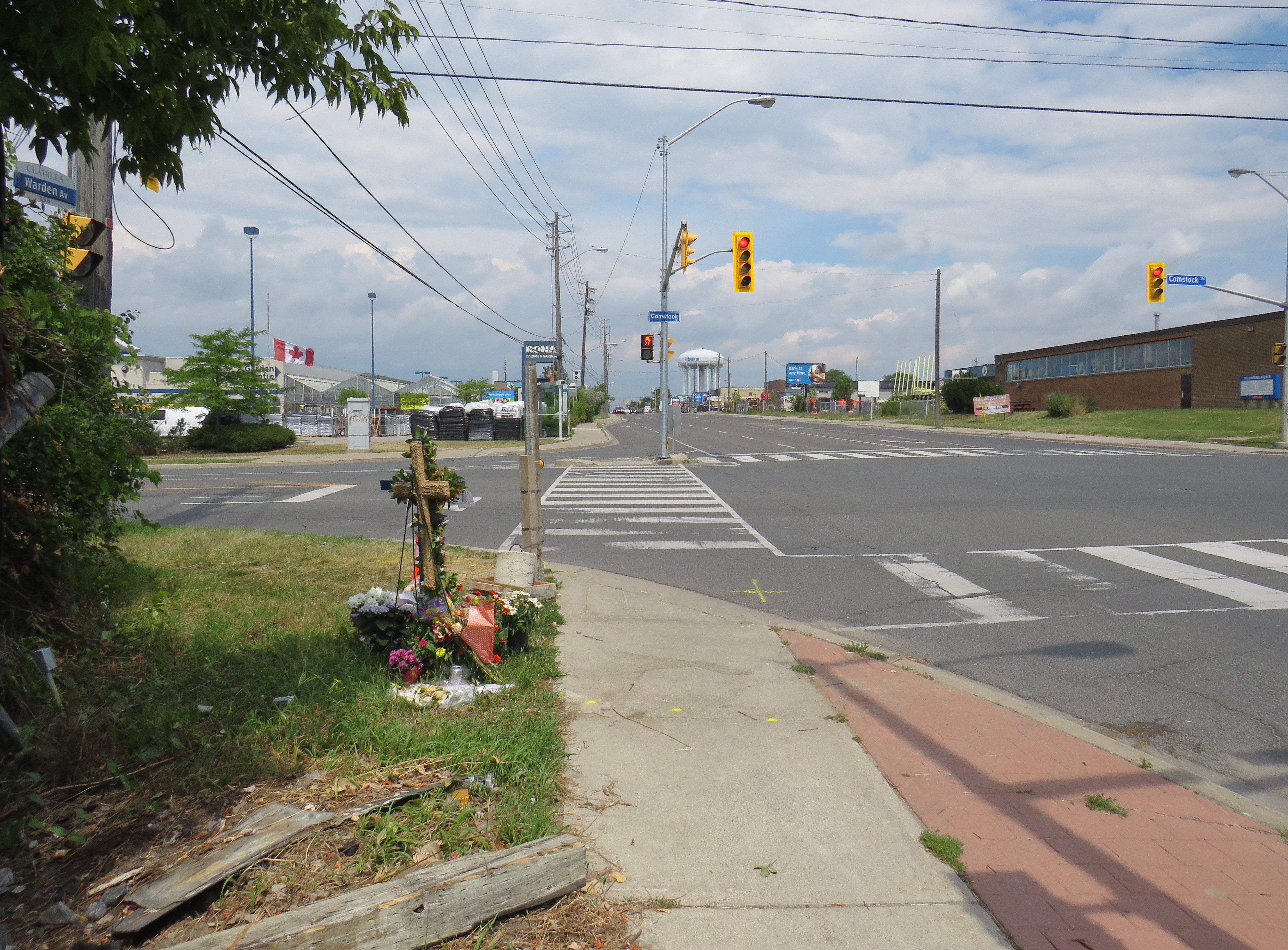
    A week after the deadly collision, I visited the intersection. On the southwest corner of Warden and Comstock, a roadside memorial was set up with flowers and a wooden cross. A temporary wooden pole held up a new pedestrian “beg button” for walkers to get across Warden Avenue. The Kia’s path into the sidewalk and the fence was very much visible, though all debris from the collision was cleaned up.

    Appeal to witnesses following a deadly collision at Warden Avenue and Comstock Road

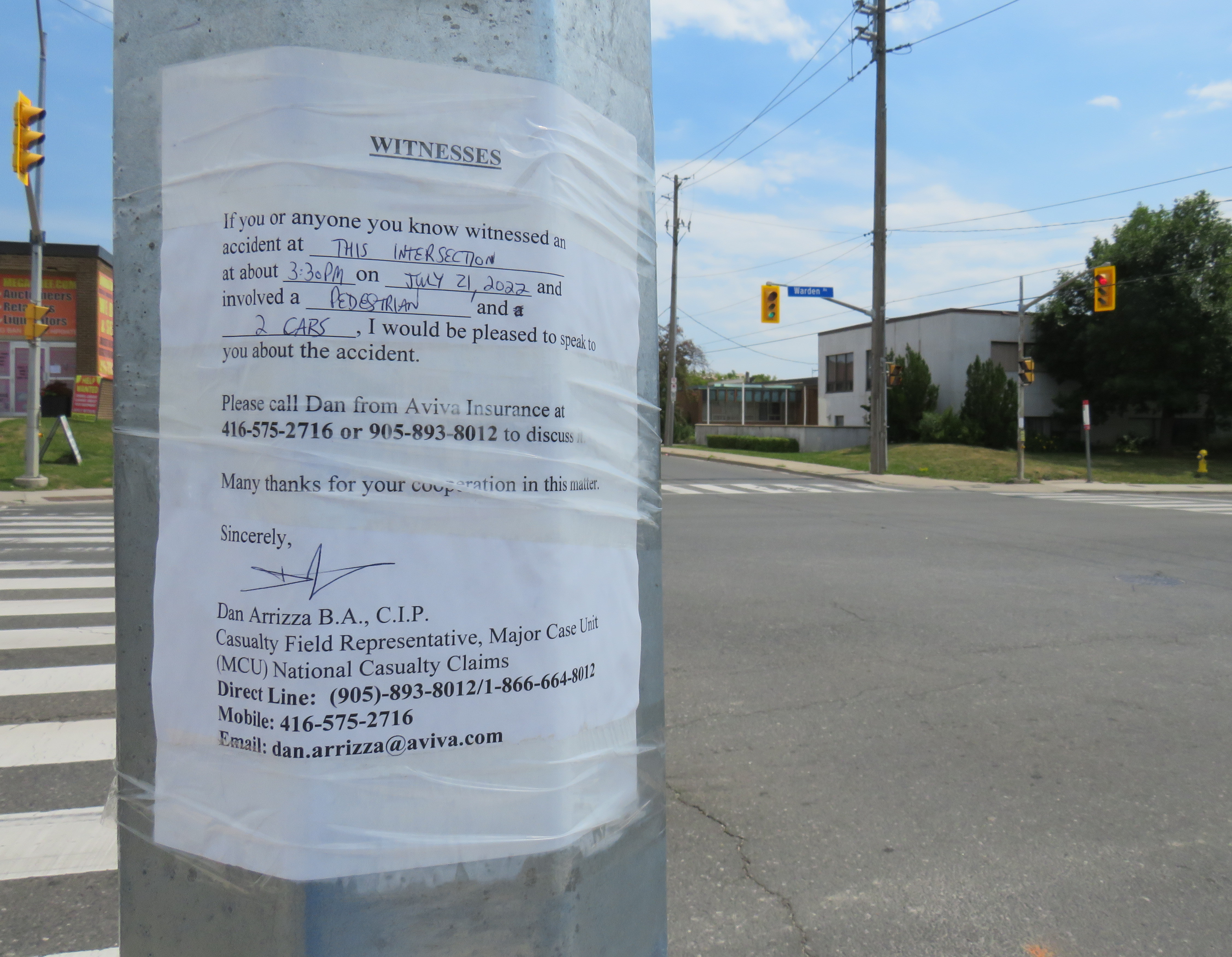
    The collision was still being investigated. While the Toronto Police were looking for witnesses to the collision, an investigator from Aviva Insurance was also looking for witnesses; several notices were taped to nearby traffic poles.

    Without knowing all the facts of the collision — which are unlikely to be reported in the news media — it would be fair to assume that speed and/or inattentive driving were at fault, but the design of the intersection — as well as Warden Avenue and Comstock Road themselves — are also to blame.

    (more…)
  • Toronto’s secret station stairways

    Toronto’s secret station stairways

    A partially hidden stairway on Dupont Street leads to the site of the lost CP West Toronto Station

    Since 1853, the year that the Ontario, Simcoe & Huron Railway first laid track at the city’s waterfront, Toronto has been criss-crossed by rail corridors. With the exception of the Ontario & Quebec Railway (a subsidiary of Canadian Pacific), every rail line built converged on Toronto’s downtown waterfront, and radiated out across the province, with connections to neighbouring provinces and states. Though Toronto’s first Union Station was built in 1858 by the Grand Trunk Railway (which also hosted two competing railways that the GTR later acquired), there was still a need for smaller stations outside the downtown core.

    Outlying stations within the city limits, such as East Toronto (Danforth), Riverdale, and Don Stations in the east, Parkdale, West Toronto, Davenport, and Sunnyside Stations in the west, were particularly important prior to modern dispatch and signalling systems. Station agents at stops outside the city centre were useful to commuters, while the station agent would deliver important messages to train crews entering the congested downtown railyards and passenger facilities. Mail could be collected, delivered, and processed for local residents and businesses. Passengers could purchase tickets without needing to go all the way downtown.

    In the early 1900s, Canadian Pacific — tired of delays with constructing a new third Union Station — built a grand station where its original Ontario & Quebec mainline crossed Yonge Street. Though the station was popular with the area’s affluent residents, CP closed the station during the Depression. (Today, it’s a magnificent LCBO flagship store.)

    Outside the old City of Toronto, there were staffed passenger stations at Long Branch, Mimico, Scarborough Junction, Port Union, Agincourt, Leaside, Downsview, Weston, and Islington.

    By the end of the 1960s, many of these stations were closed. In southern Ontario, mail was being sent by truck instead of rail, sorted in large processing facilities. The loss of the mail contracts spelled the end of many rural passenger rail services. Modern centralized traffic control and wireless communication systems did away for the need for station staff to relay messages and orders to passing trains. Though there were still dozens of passenger trains arriving and departing Union Station, these trains, mostly on the Montreal-Windsor corridor, made fewer stops. In 1967, GO Transit replaced the remaining all-stops commuter service on CN’s line between Hamilton and Toronto; it eventually replaced most of CN’s stations on what are now the Lakeshore, Kitchener, and Stouffville Lines with new station stops or built new facilities at old station sites that better served suburban park-and-ride commuters. GO also added new stations such as Guildwood, Bloor, and Old Cummer.

    Within the City of Toronto, there are only four passenger railway station buildings preserved: Union Station, CP North Toronto Station, Mimico Station, and Don Station. Mimico and Don Stations were moved off-site, while only Union Station remains in continuous passenger service. Other stations burned down, were demolished, or were simply left to rot. In a few places, though, old staircases provide clues to these long-lost stations.

    Don Station

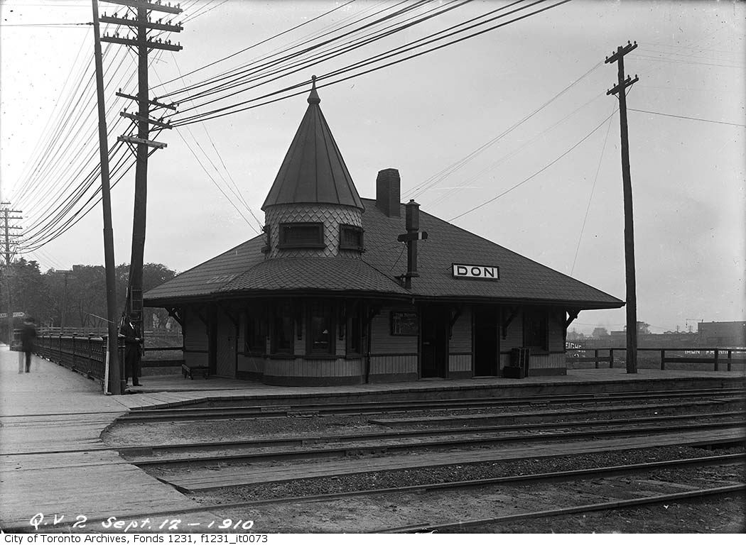
    Don Station was built by CP in 1896 to serve its new branch to Union Station from the Ontario & Quebec mainline at Leaside. Located at Queen Street at the Don River, it was an important waystation for train crews to receive orders before arriving at Union Station or before departing northeastward on the long trestle towards Leaside and Montreal. When Canadian Northern built its mainline through the Don Valley in 1906, it shared the approach tracks with CP and also used Don Station.

    Originally, the CP and CNoR tracks crossed Queen Street at grade. After a catastrophic streetcar-train crash further east on Queen Street, the City of Toronto pushed to grade-separate all major road crossings. In 1911, a higher-level bridge was built that spanned the Don River and the railway tracks. Today, it also spans the Don Valley Parkway.

    The station closed in 1967 when the Toronto-Peterborough-Havelock train stopped serving Don, and the station building was moved to Todmorden Mills in 1969. In 2008, the station was moved again, to Roundhouse Park. It now hosts passenger trains again; albeit a miniature train operated by the Toronto Railway Museum.

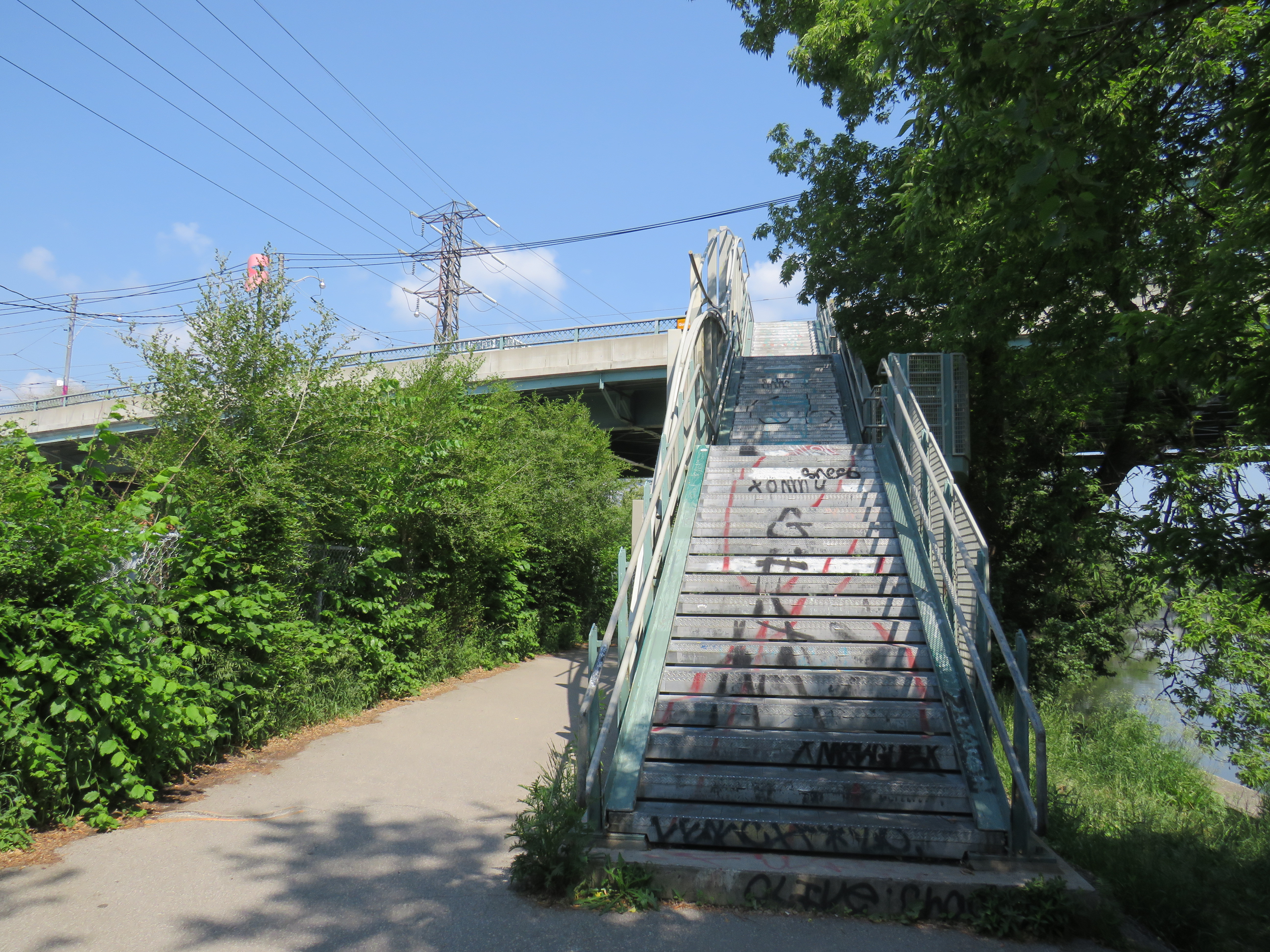
    The original wooden stairway from Queen Street that connected to Don Station was removed by the early 1960s and replaced by a metal staircase. The metal structure has since been refurbished and now connects Queen Street with the Lower Don Trail.

    Stairway from the Lower Don Trail to Queen Street East
    Don Station in 1910, before the higher-level Queen Street bridge was constructed
    City of Toronto Archives Fonds 1231, Item 73

    Parkdale CN Station

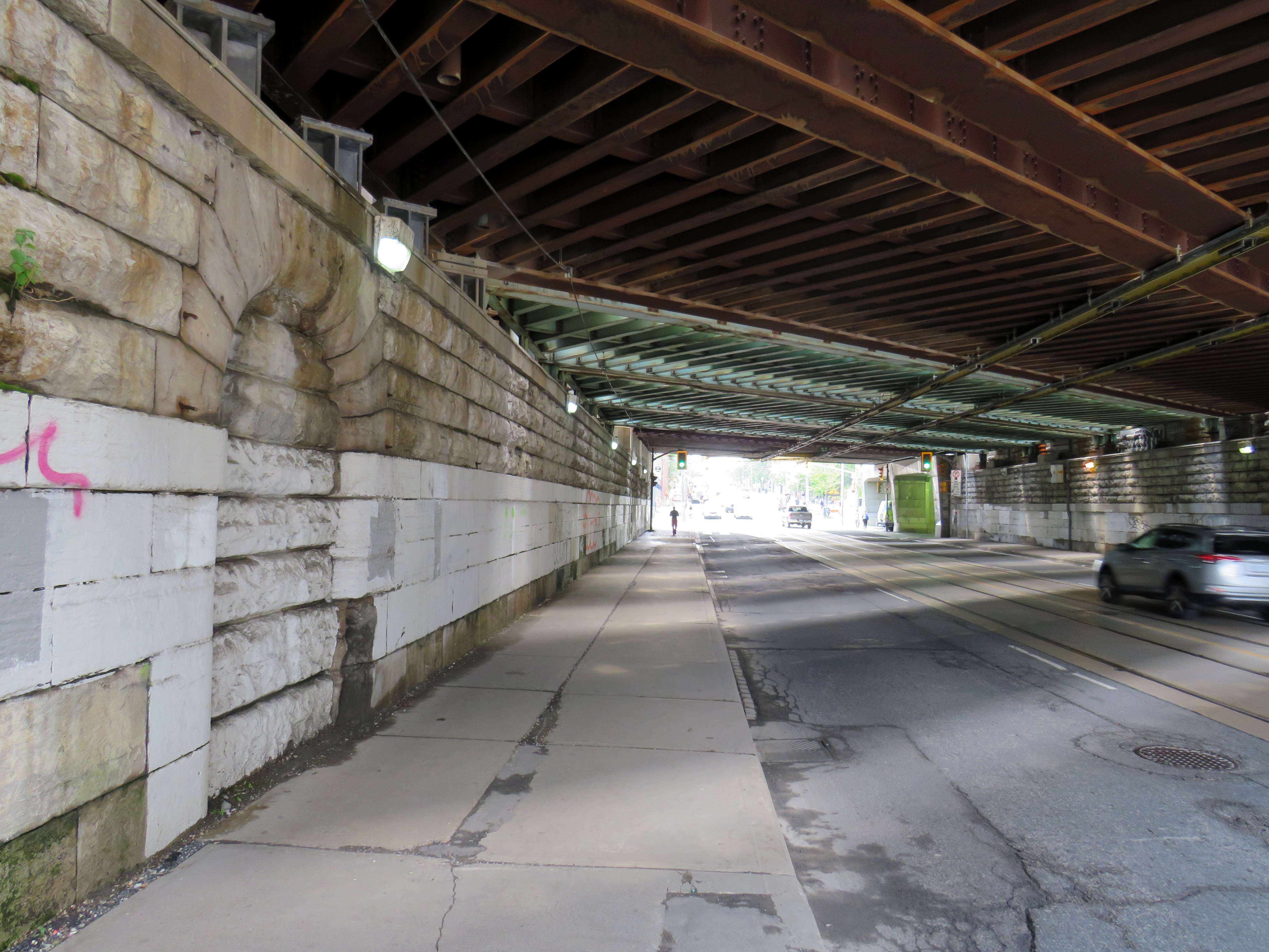
    Sealed portal to CN Parkdale Station

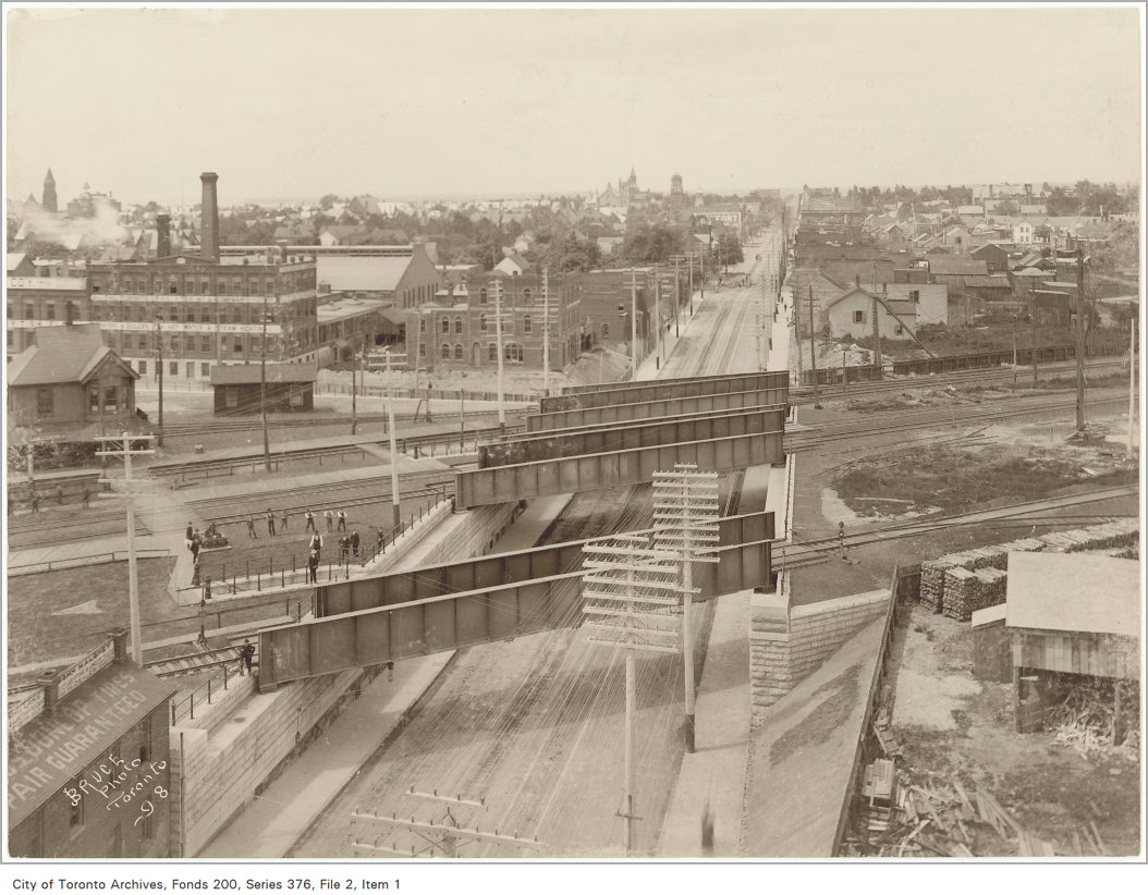
    Until 1960, every train on the Toronto-Kitchener-London route made a stop at Parkdale, near the corner of Queen and Bathurst Streets. The Queen Street Subway, completed in 1898, was one of the first road-rail grade separations in the city. The underpass allowed streetcars and traffic to avoid the multiple Grand Trunk and Canadian Pacific mainline and service tracks that crossed Queen Street. Both Grand Trunk (later CN) and CP had stations at Parkdale, though the wooden GTR/CN station was located between the tracks and had to be accessed by a stairway from the south side of the Queen Street underpass.

    The CN station was closed in 1974, after GO Transit began service to Brampton and Georgetown, opting for a new station at Bloor Street, close to the Bloor-Danforth Subway. The station building was moved nearby for heritage preservation, but was set on fire at its temporary location at Queen Street and Roncesvalles Avenue.

    A bricked up archway betrays the old passage to the now-demolished station.

    The new Queen Street Subway, 1898. Parkdale CN Station is to the left of this image, but the stairway down to street level is clearly visible.
    City of Toronto Archives Fonds 200, Series 376, File 2, Item 1
    Old streetcars headed to Haileybury, Ontario pass by the CN Parkdale Station on October 14, 1922. The streetcars, which were slated for scrapping, where being sent north to provide shelter after a disastrous forest fire.
    – City of Toronto Archives Fonds 16, Series 71, Item 1601

    West Toronto CP Station

    Both CN and CP had stations at West Toronto. The Grand Trunk (later CN) station was located on Old Weston Road near Davenport Road. The CN station closed in the early 1980s and was demolished in 1999 after being left abandoned to the elements and vandals.

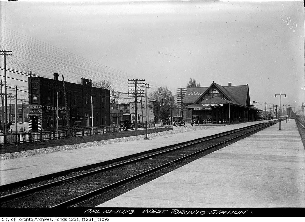
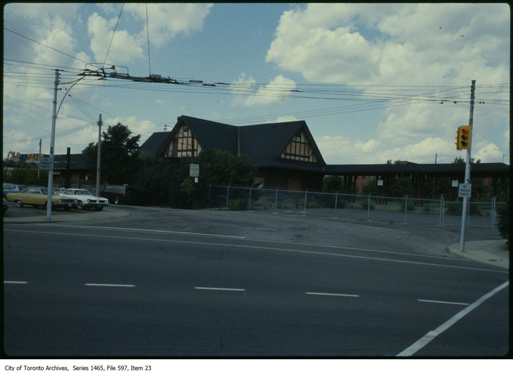
    The CP station was located to the south, on Old Weston Road just north of Dupont and Dundas Streets. As the town of West Toronto (originally known as Toronto Junction) built up around the junction between CP’s Ontario & Quebec, Credit Valley, and Toronto, Grey and Bruce Railways, the CP station was the pride of the community. The last station on the site, completed in 1911, was a large building in the Tudor style, with a long canopy. The last train to serve West Toronto, CP’s Canadian, departed in 1978, and CP controversially demolished the station under cover of darkness in 1982.

    CP West Toronto Station, 1923 City of Toronto Archives, Fonds 1231, Item 1092
    CP West Toronto Station just prior to demolition in 1982
    – City of Toronto Archives, Series 1464, File 597, Item 23

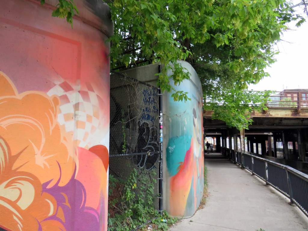
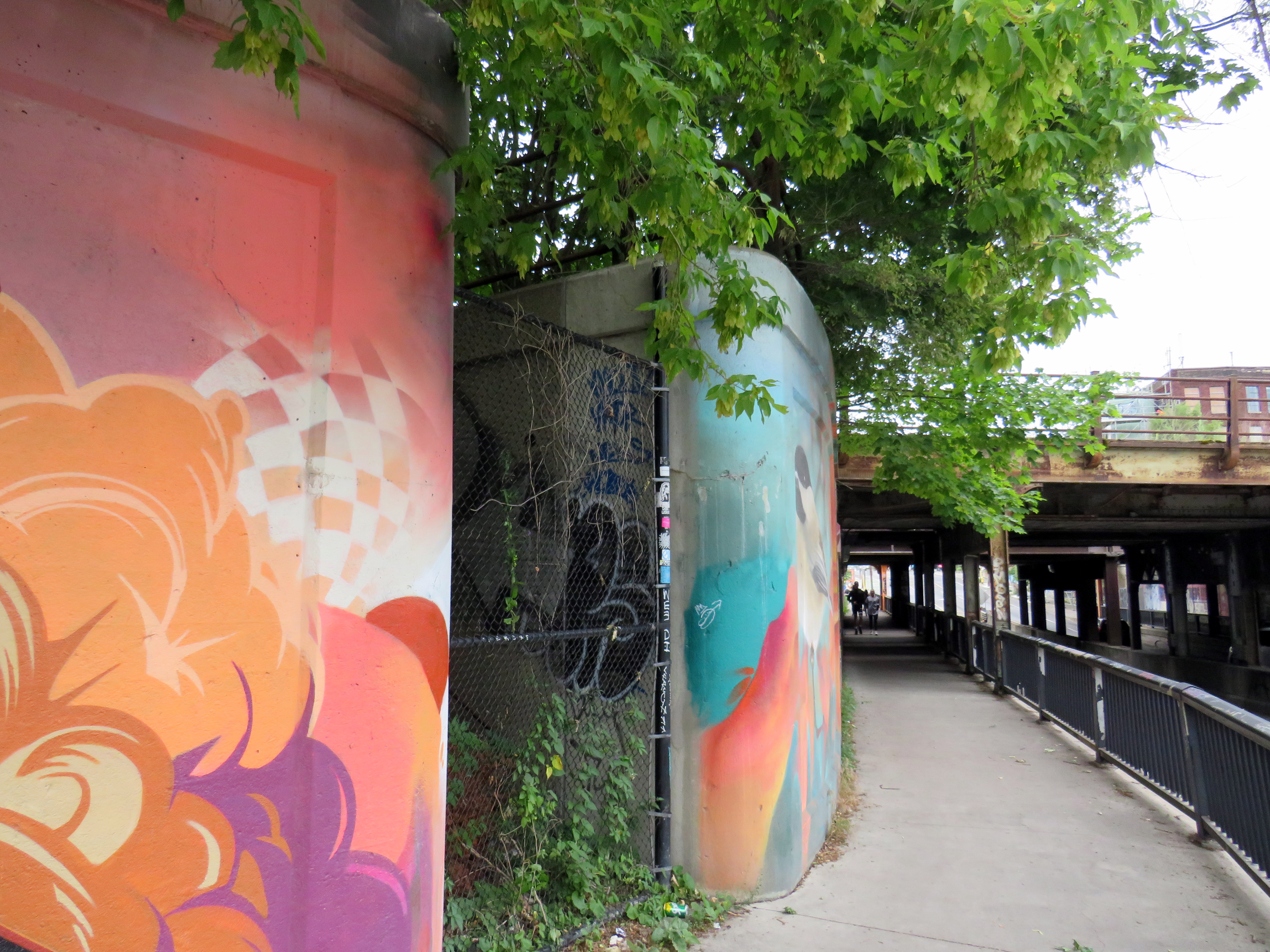
    At the south end of the station platform, a stairway led down to the north side of Dupont Street. Though it is fenced off, the stairway is still very much visible just west of the railway underpass. The concrete retaining wall has been brightened up by local graffiti artists.

    Fenced-off stairway from the north side of Dupont Street, just east of Dundas Street, leads to the site of the now-demolished CP West Toronto Station

    St. Clair Avenue Station

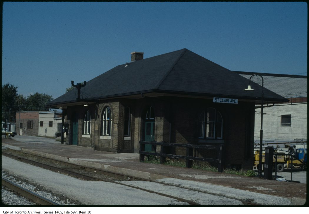
    CN St. Clair Avenue Station just prior to its final closure, c. 1983
    – City of Toronto Archives, Series 1465, File 597, Item 30

    St. Clair Avenue Station was completed in 1931, as part of a grade separation project that finally allowed through streetcar service on St. Clair West. The small brick structure replaced an older station at Davenport Road, which was soon demolished.

    St. Clair Avenue served CN trains between Toronto, Northern Ontario, and Western Canada, though passenger services declined through the 1960s and 1970s. When GO Transit took over the local Barrie train from VIA, it cut the stop at St. Clair Avenue. The station was closed for good when VIA’s Canadian was rerouted from the CN Newmarket Subdivision in 1985. Like other disused passenger stations, the building suffered from neglect, vandalism, and arson, before being demolished by CN in 1999.

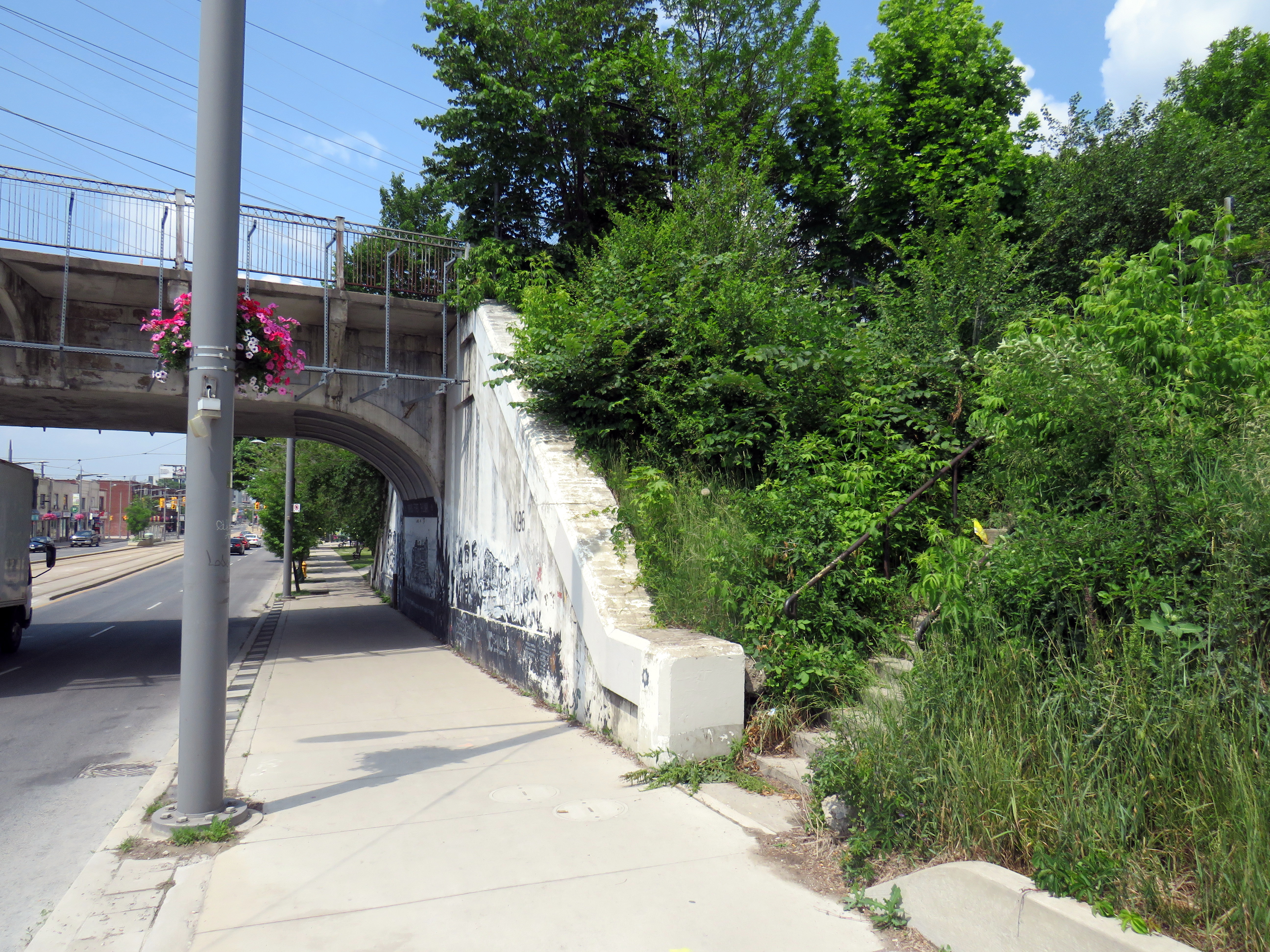
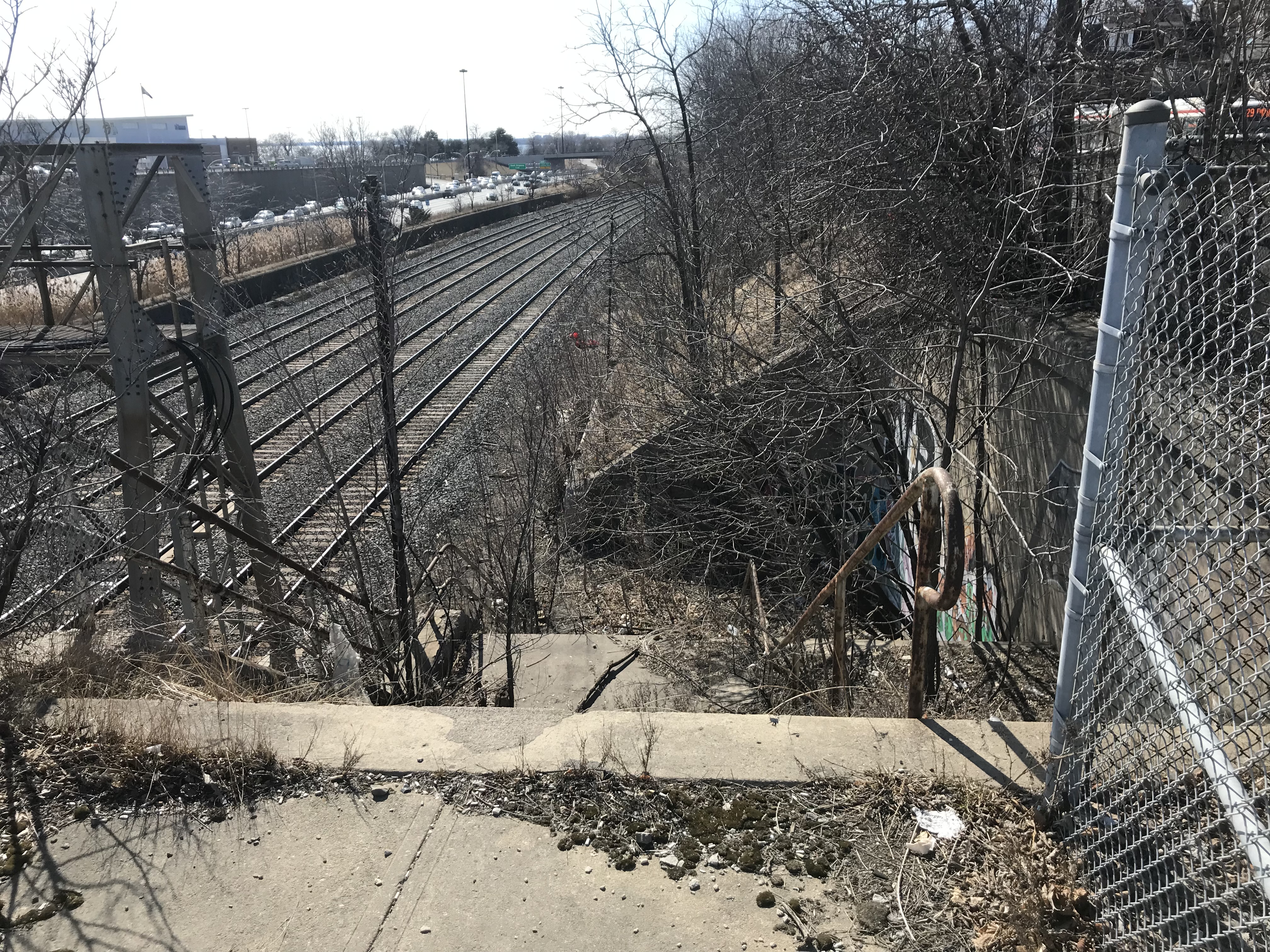
    The remains of the station platform are still visible from the east side of GO trains on the north side of St. Clair, especially in winter and early spring. From St. Clair Avenue itself, a stairway, partially hidden by greenery, leads up to the old station site.

    Abandoned stairway north from St. Clair Avenue West, near Caledonia Road, leads to the site of the CN St. Clair Avenue Station

    Exhibition Station

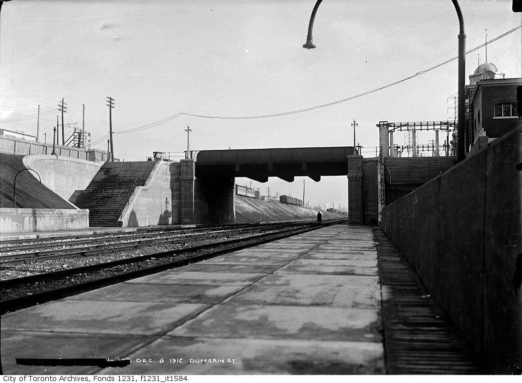
    New Grand Trunk Railway Exhibition Station, 1912. City of Toronto Archives, Fonds 1231, Item 1584

    In 1912, the Grand Trunk Railway opened a new station that was intended to see train service for only a few weeks a year. Exhibition Station, constructed at the foot of Dufferin Street, was an anomaly. It had no full-time station agent, but it featured wide platforms and staircases leading up to Exhibition Place’s Dufferin Gates. Special trains during the Canadian National Exhibition would quickly load and offload fairgoers. As CP, through its part-ownership of the Toronto, Hamilton & Buffalo Railway, had running rights on the GTR/CN tracks between Union Station and Hamilton, it too, could send trains direct to the CNE.

    Exhibition Station remained in use until the early years of GO Transit, when it built a new station farther east in the early 1970s. Upgraded since then, the current Exhibition Station will become a multimodal hub with the construction of the Ontario Line. Meanwhile, the old stairways and platforms remain, though fenced off.

    Stairway down to the westbound platform at the old CN Exhibition Station at Dufferin Street

    Agincourt CP Station

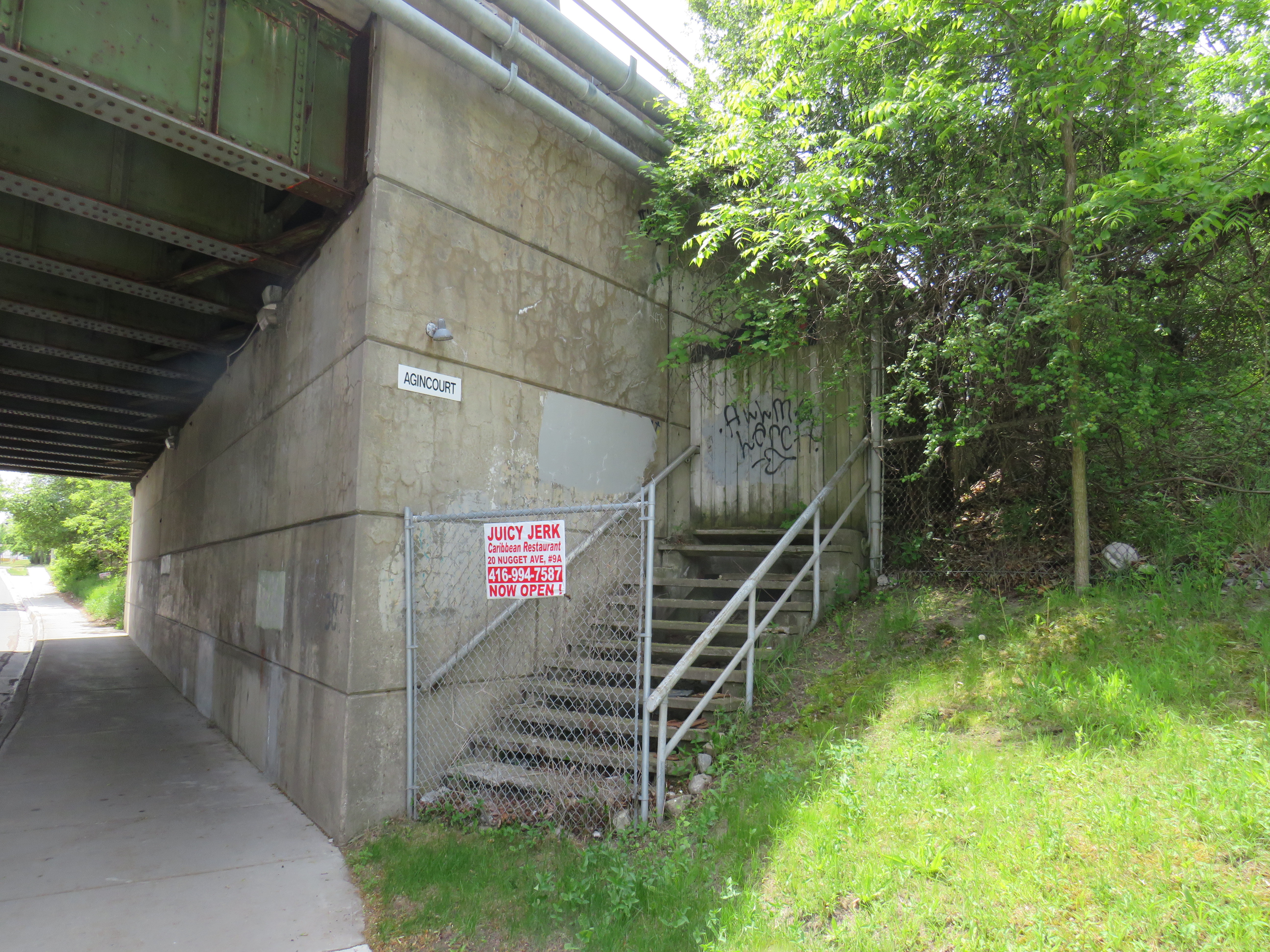
    North side stairway at Brimley Avenue. Note the sign reading “Agincourt” on the underpass structure.

    Both CN and CP had stations called Agincourt in North Scarborough, but neither of the historic station buildings remain. The CN station, now the location of Agincourt GO Station, was on Sheppard Avenue East near Kennedy Road, at the centre of the rural settlement. The CP station, originally built in 1884 for its Ontario & Quebec subsidiary, was farther east, located between Sheppard Avenue and Brimley Road. Though the CN station (built in 1871 for the Toronto & Nipissing Railway) was demolished in 1982, the station site remains in active use. Little remains of the CP station.

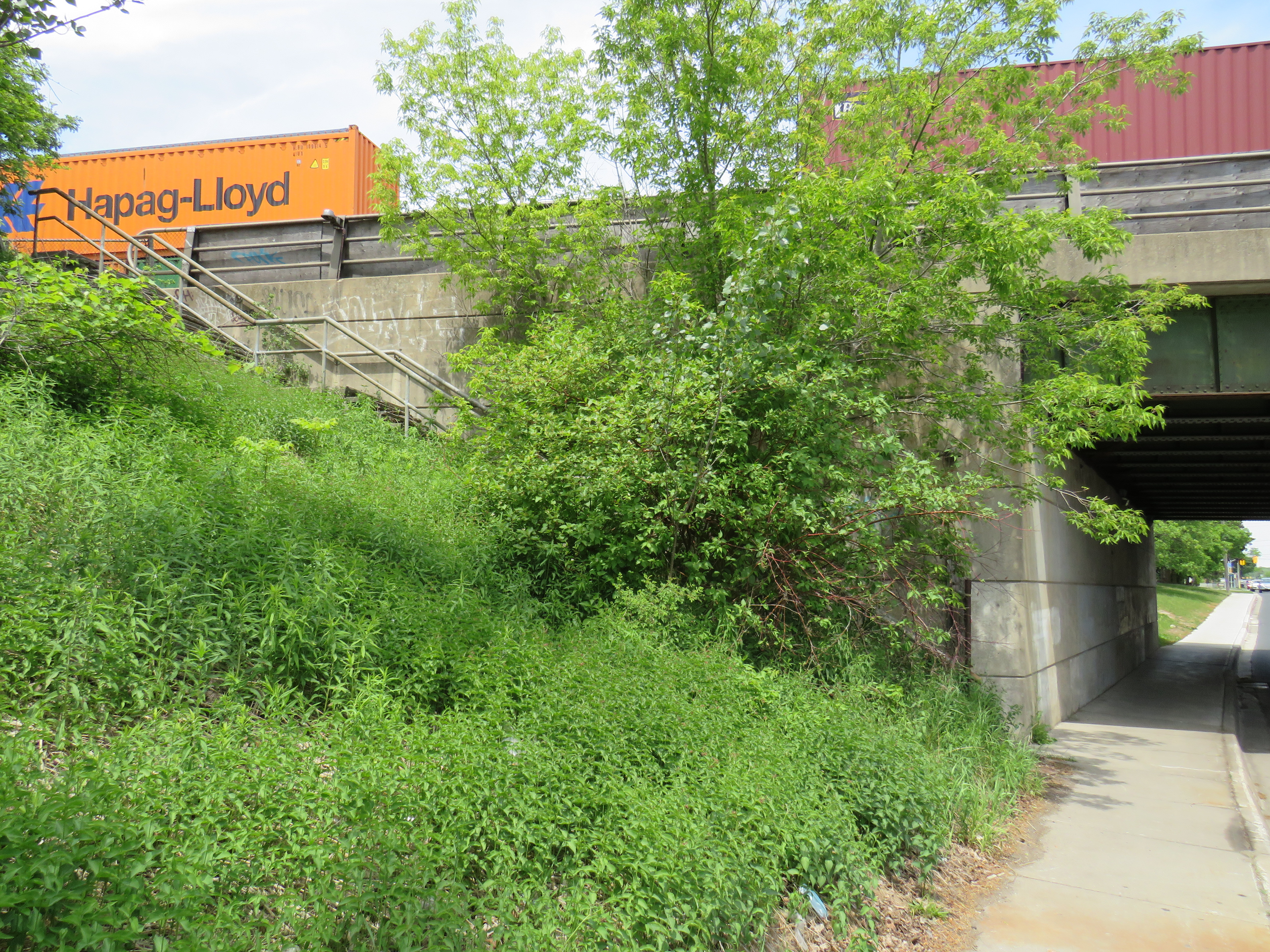
    On the west side of a wide underpass on Brimley north of Sheppard, two fenced-off stairways lead to the north and south side of the CP tracks. In 1960, CP constructed a new freight classification yard in northern Scarborough; as part of that project, it built new underpasses at Sheppard, Brimley, and McCowan Road, and a large overpass for Markham Road. CP replaced the 1884 station with a smaller station building to serve its remaining passenger trains between Toronto, Peterborough, and Havelock. The station building was on the south side of the tracks, with a driveway leading off Sheppard Avenue to the station and a small parking lot, but CP built the stairways on Brimley for walk-up traffic and to provide a safe passage under the tracks between platforms.

    Though the rail diesel coach service survived until the 1990 VIA Rail cuts, the station building was demolished in the late 1970s.

    South side of CP line at Brimley Avenue

  • A front row seat to Toronto’s Carmaggedon

    A front row seat to Toronto’s Carmaggedon

    On Saturday, my spouse and I decided to take advantage of the GO Transit weekend day pass and take the train to Hamilton for a short excursion. We did some shopping on James Street North in Downtown Hamilton and on Ottawa Street in the city’s east end, where there’s a great cluster of fabric, decor, and antique shops, as well as cafes and restaurants.

    The new weekend passes, which cost $10 for one day and $15 for two days, have been a major contributor to GO Transit’s ridership recovery. Though weekend ridership has recovered to 90 percent of pre-pandemic levels (despite lower service levels on many routes), weekday ridership is only half of what it was in 2019.

    On our return trip to Toronto, we decided to take the Route 16 express bus, departing from Hamilton GO Centre at 3:30. As the train between Union and Hamilton’s West Harbour Stations runs only every hour, it seemed that the express bus to Union Station would be the fastest and most convenient option. How wrong we were.

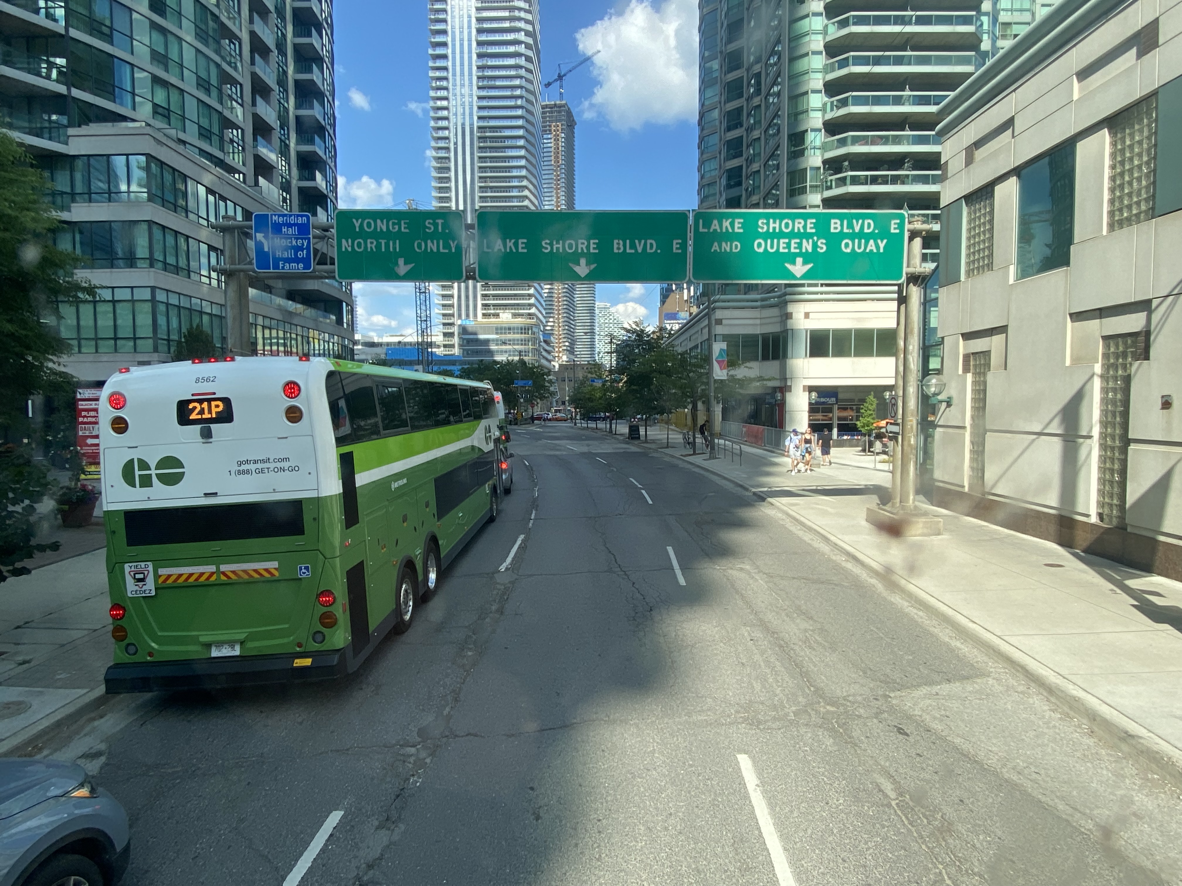
    A line of GO buses attempting to turn left from Lake Shore Boulevard to Yonge Street

    As we were among the first to board the double-decker bus, we had front row seats to Toronto’s Carmageddon.

    Despite it being a beautiful afternoon on the long weekend, the ride on Highway 403, the Queen Elizabeth Way, and the Gardiner Expressway was uneventful, with only a few spots where traffic moved slowly. Until the bus got off the York-Bay-Yonge ramp, we were making decent time. That is when we were confronted with a long line of cars and trucks, all trying to turn north on York, Bay, and Yonge Streets.

    The new Union Station Bus Terminal, located on the north side of the westbound Lake Shore Boulevard lanes, requires buses coming from the west to turn left on to Yonge Street from eastbound Lake Shore, and then turn left again onto westbound Lakeshore before turning right into the terminal itself.

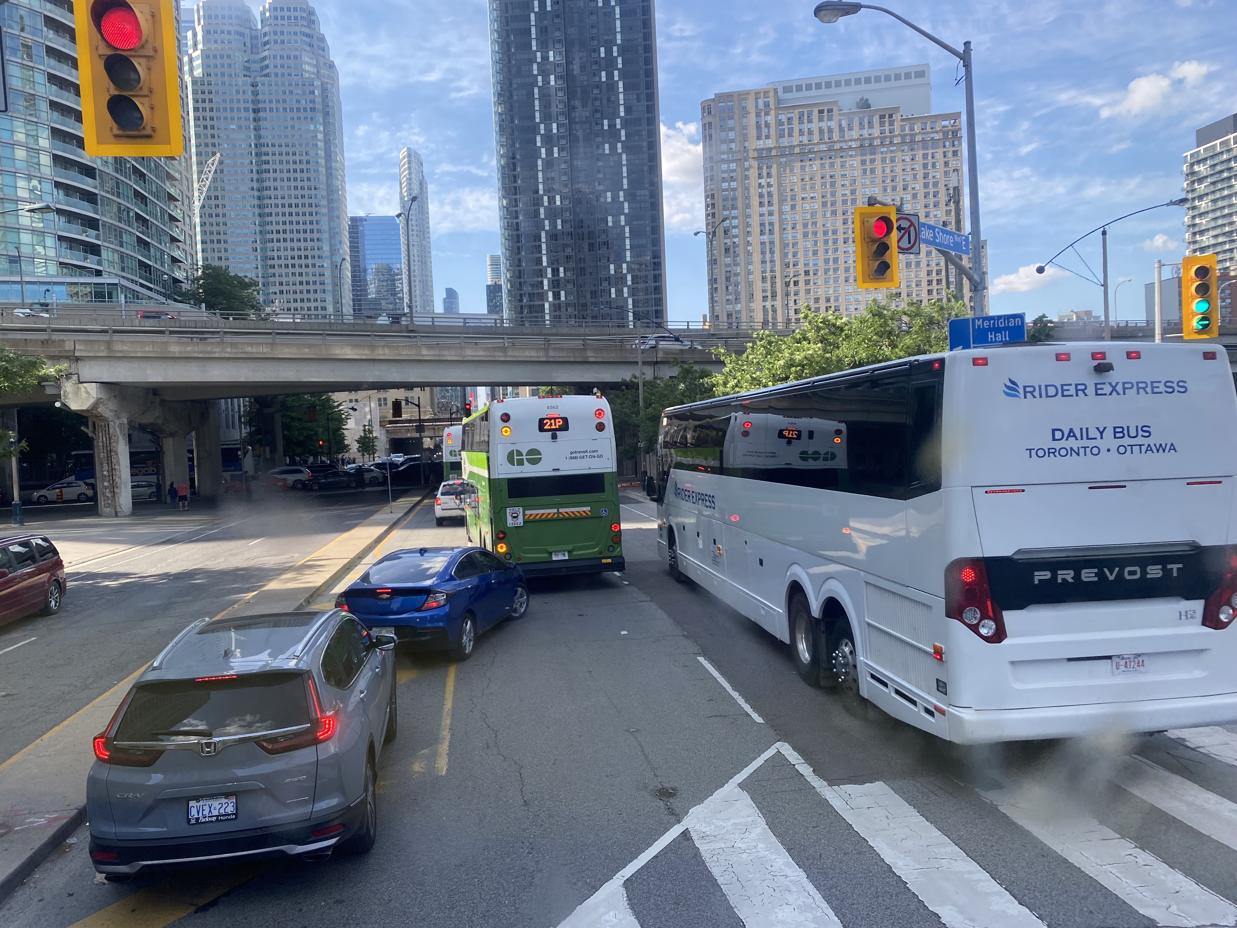
    After finally turning north from eastbound Lake Shore Boulevard, private vehicles, a Rider Express bus, and GO Transit buses attempt to turn left onto a gridlocked westbound Lake Shore Boulevard

    But with construction obstructing two westbound lanes of Lake Shore at Bay Street, drivers leaving the first of two Blue Jays games that afternoon (a rare doubleheader hosting the Tampa Bay Rays), and other drivers arriving for the evening Jays game, an Eric Church concert at Scotiabank Arena, along with the usual weekend traffic, traffic could not move, creating literal gridlock. Police or traffic wardens that could monitor and manage the gridlock were nowhere to be seen.

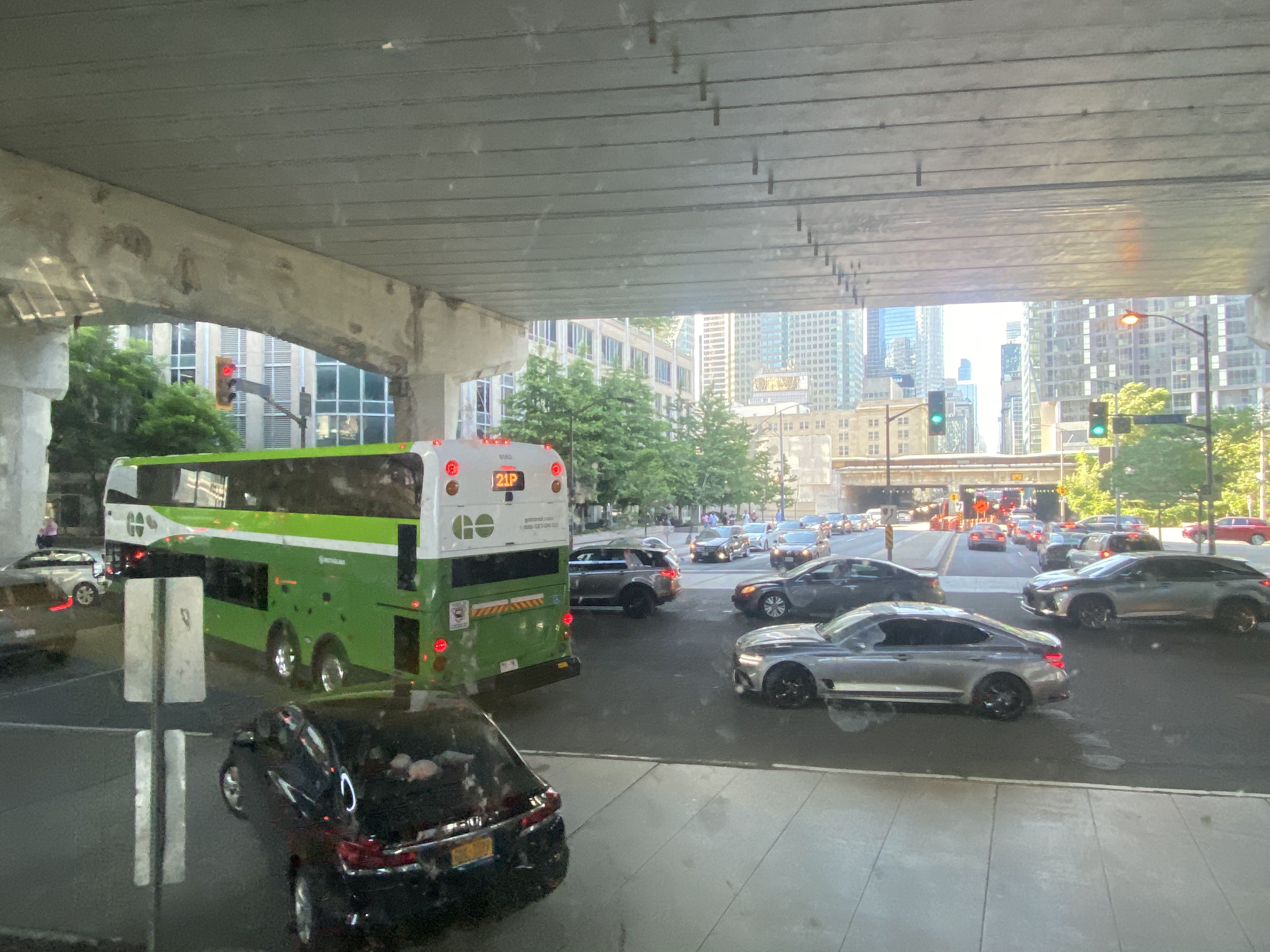
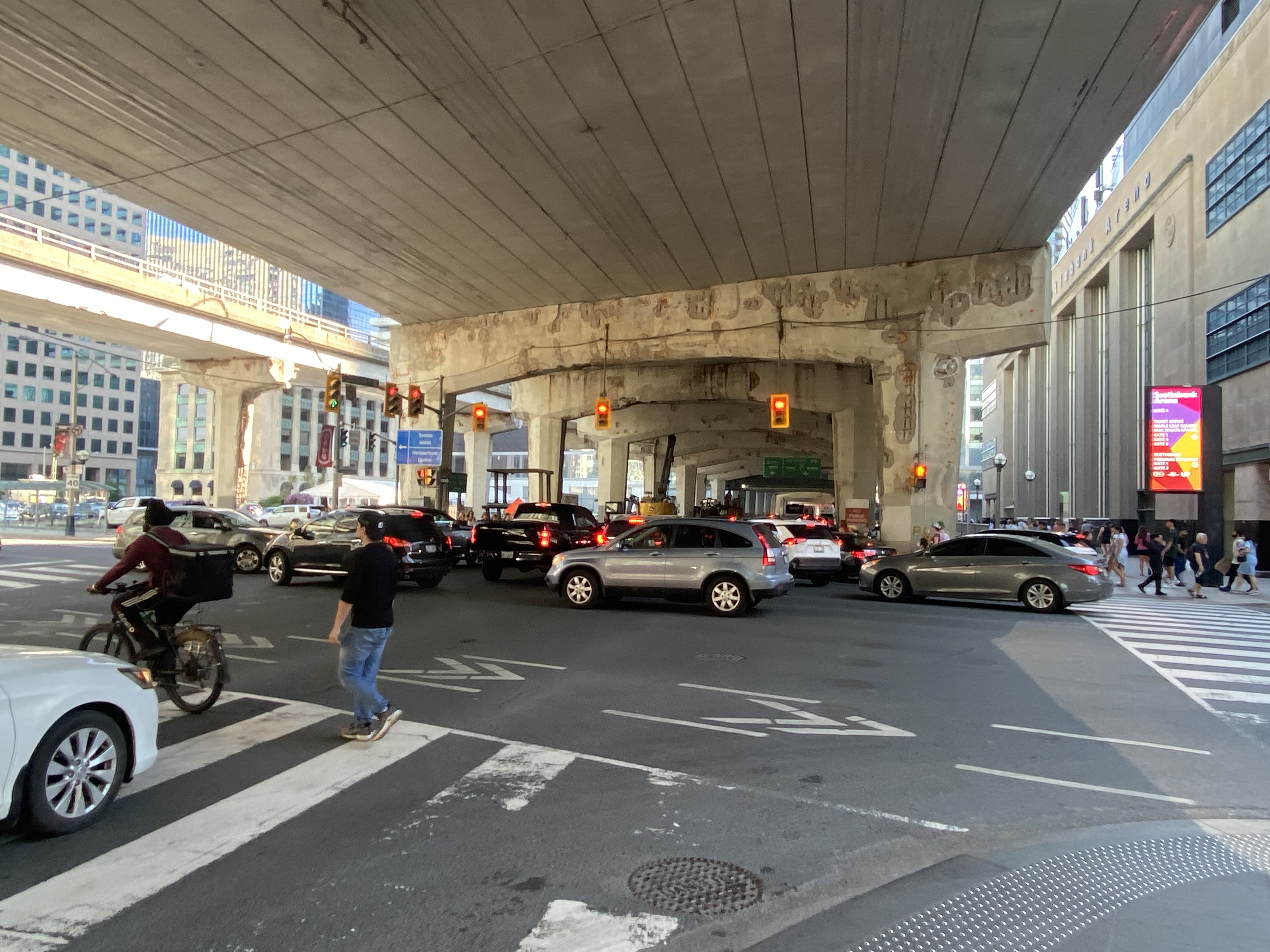
    Motorists jam the intersection of Lake Shore Boulevard West and Yonge Street
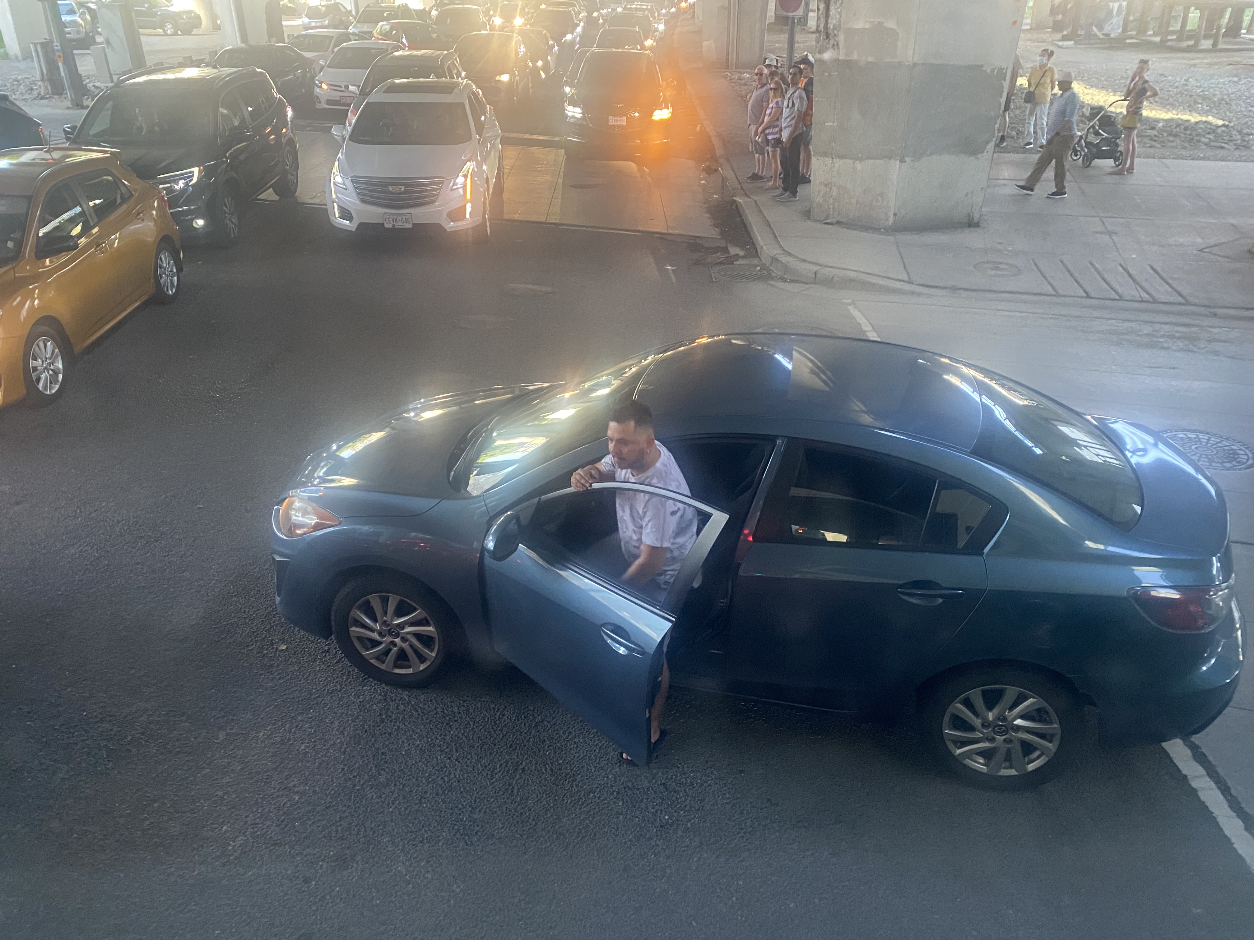
    One driver expresses his frustration with the traffic

    At 5:50, 2 hours and 20 minutes after the bus departed Hamilton GO Centre, we were let out on the curb outside the terminal entrance. In response to the backlog of buses attempting to enter and exit the Union Station terminal, GO cut back the Route 16, meeting the half-hourly Lakeshore West train service at Aldershot Station (one stop short of West Harbour). Several Route 16, 21, and 31 trips were cancelled due to the traffic in the downtown core, requiring some customers in places like Milton and Georgetown to wait an entire hour for the next bus.

    After similar gridlock conditions on Sunday, July 3, Route 21 (Milton Corridor) and Route 31 (Kitchener Corridor) buses were rerouted to Port Credit GO, requiring a transfer to trains there.

    The new terminal’s location is excellent for consolidating all intercity bus and rail services and is much safer than the old Union Station Terminal or the dilapidated Metro Toronto Coach Terminal at Bay and Dundas Streets. Direct, indoor connections can be made with the subway, several hotels, Scotiabank Arena, and to the vast PATH system of underground walkways. Its major failure, however, is the lack of dedicated bus lanes to speed highway coaches in and out of the facility.

    On Lake Shore Boulevard. The bus entrance to the Union Station terminal is at right

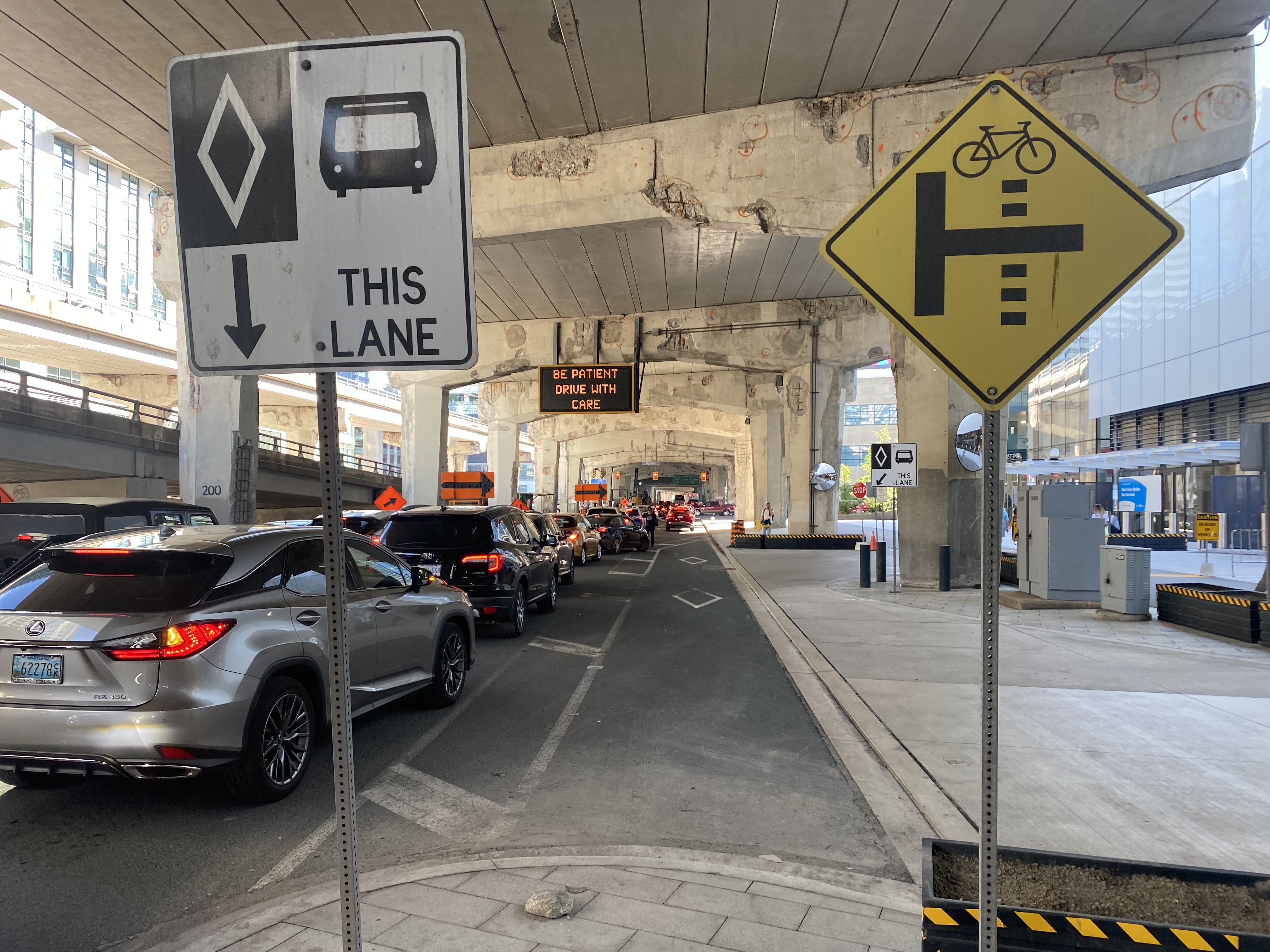
    There is an exceptionally wide sidewalk on the north side of Lake Shore approaching the bus entrance to the terminal, and an extremely short bus lane in front of the terminal’s entrance and exit. It is no wonder why some private coach operators, such as FlixBus and Onex, opt for on-street stops, rather than the terminal used by GO, Megabus, Rider Express, TOK, and Ontario Northland.

    Toronto’s shortest and least-effective bus lane, in front of the Union Station Bus Terminal. Note the sign reading “be patient – drive with care” above.

    A dedicated bus lane for the entire distance between Yonge and Bay Streets would undoubtedly improve operations. A dedicated left turn lane from Yonge to westbound Lakeshore would also allow easier access to the terminal from the west, where the majority of GO and intercity coach buses arrive from. Similar dedicated left turn lanes at Queen Street and Central Park Drive in Brampton allow Brampton Transit buses to quickly enter and exit the Bramalea Terminal. Better traffic management, including police enforcement, would help ensure a clear path for transit and coach buses.

    The gridlock continued west of Bay Street, as motorists lined up to get to the Gardiner Expressway or go west on Lake Shore Boulevard

    GO Transit’s reaction, to reroute buses to the already-crowded Lakeshore West Train, is not a sustainable solution, though it is the only effective tool it has at the moment. Though Route 16 passengers are not taken far out of their way with a transfer at Aldershot GO, the detour is more onerous for some Route 21 and all Route 31 passengers forced to backtrack to Port Credit GO for a forced transfer there.

    Stouffville and Barrie Corridor passengers were spared the hassles with the return of weekend train service earlier this year. Unfortunately, Canadian Pacific’s control of almost the entirety of the Milton Corridor precludes midday, evening, and weekend train service, but there’s an opportunity to finally bring limited weekend train service to the Kitchener Corridor. GO Transit already offers an hourly midday and evening weekday train service to Mount Pleasant Station in Brampton, despite CN’s control of the corridor west of Bramalea Station.

    Track improvements completed nearly 20 years ago (an additional track between Bramalea and Mount Pleasant and a second platform at Brampton GO Station) provides the capacity for hourly GO trains and CN’s freight operations. Weekend Route 30 bus service between Kitchener and Bramalea can provide a reasonable and reliable bus link until corridor improvements, such as new passing tracks, are completed between Georgetown and Kitchener.

    As I was sitting in traffic for an hour, I found myself aggravated once again by Blue Jays CEO Mark Shapiro lobbying the city to end the Sunday closure of Lake Shore Boulevard West to allow for the city’s (much-diminished) Active TO program. In a letter addressed to Mayor John Tory, General Manager of Transportation Services Barbara Gray, and the city clerk, Shapiro argued that “removing one of the only ways into and out of the downtown core would be extremely challenging to our fans” claiming that “on the days when Active TO has been in effect on Lake Shore, our local fans have experienced significant transit delays because traffic is grinded to a halt on all downtown routes.” (It is worth noting that the Toronto Blue Jays baseball club is a wholly-owned subsidiary of Rogers Communications. The mayor of Toronto, a former Rogers executive, remains involved with the Rogers family trust.)

    The Lake Shore closure allowed cyclists and runners to bypass the overcrowded Martin Goodman Trail along Toronto’s Western Beaches, on a section of roadway paralleled by GO Transit’s Lakeshore Corridor. The traffic congestion last weekend was completely unrelated to ActiveTO (which is now suspended on Lake Shore Boulevard, partly due to Shaprio’s lobbying) and transit riders, who make up a large percentage of the Blue Jays’ fanbase, were left in the mess that motorists made.

  • Wards and ridings: not quite representation by population

    Wards and ridings: not quite representation by population

    When Statistics Canada released the first batch of 2021 Census data, it made the new population counts available for a wide variety of geographies, from provinces and cities, to local census tracts and even city blocks. It also released data for the 338 federal electoral districts, better known as ridings.

    Because of constitutional requirements, the seats in the federal House of Commons are not allocated equally by population. For example, Prince Edward Island, with a population of 154,331, has four seats. At the other extreme, four electoral districts in Alberta and one in Brampton, Ontario have larger populations than Canada’s smallest province.

    Electoral DistrictProvince/Territory2021 Population
    LabradorNewfoundland & Labrador26,655
    EgmontPrince Edward Island35,925
    NunavutNunavut36,858
    CharlottetownPrince Edward Island38,809
    MalpequePrince Edward Island39,731
    Average109,444
    Banff-AirdrieAlberta155,580
    Calgary SkyviewAlberta159,642
    Brampton WestOntario162,353
    Calgary ShepardAlberta163,447
    Edmonton-WetaskiwinAlberta209,431

    The federal electoral districts were last drawn in 2013, following the 2011 census. As a result, fast-growing ridings, particularly in Southern Ontario, Calgary, and Edmonton, have huge populations compared to the national average.

    In Ontario, the provincial government uses the same boundaries for its provincial electoral districts, with the exception of Northern Ontario, where two additional seats help to compensate for the area’s vast and remote regions, where local MPPs may have to travel hours by car, train, or plane to meet constituents. The province imposed the same boundaries on the City of Toronto in 2018, in the middle of a municipal election for which new, fairer boundaries were just approved.

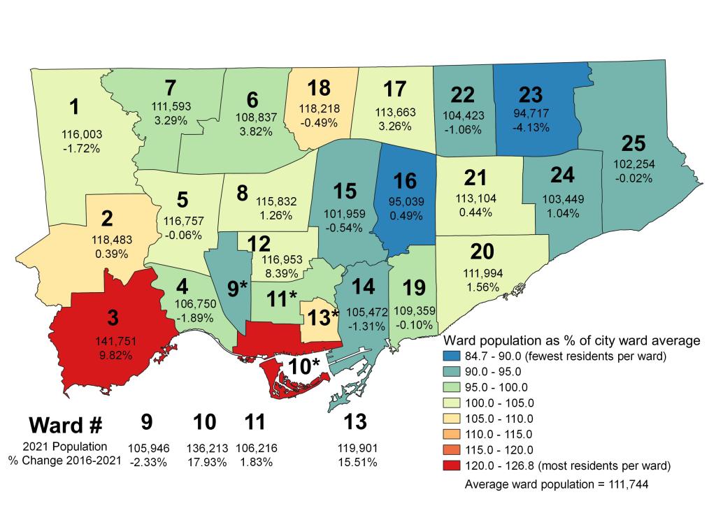
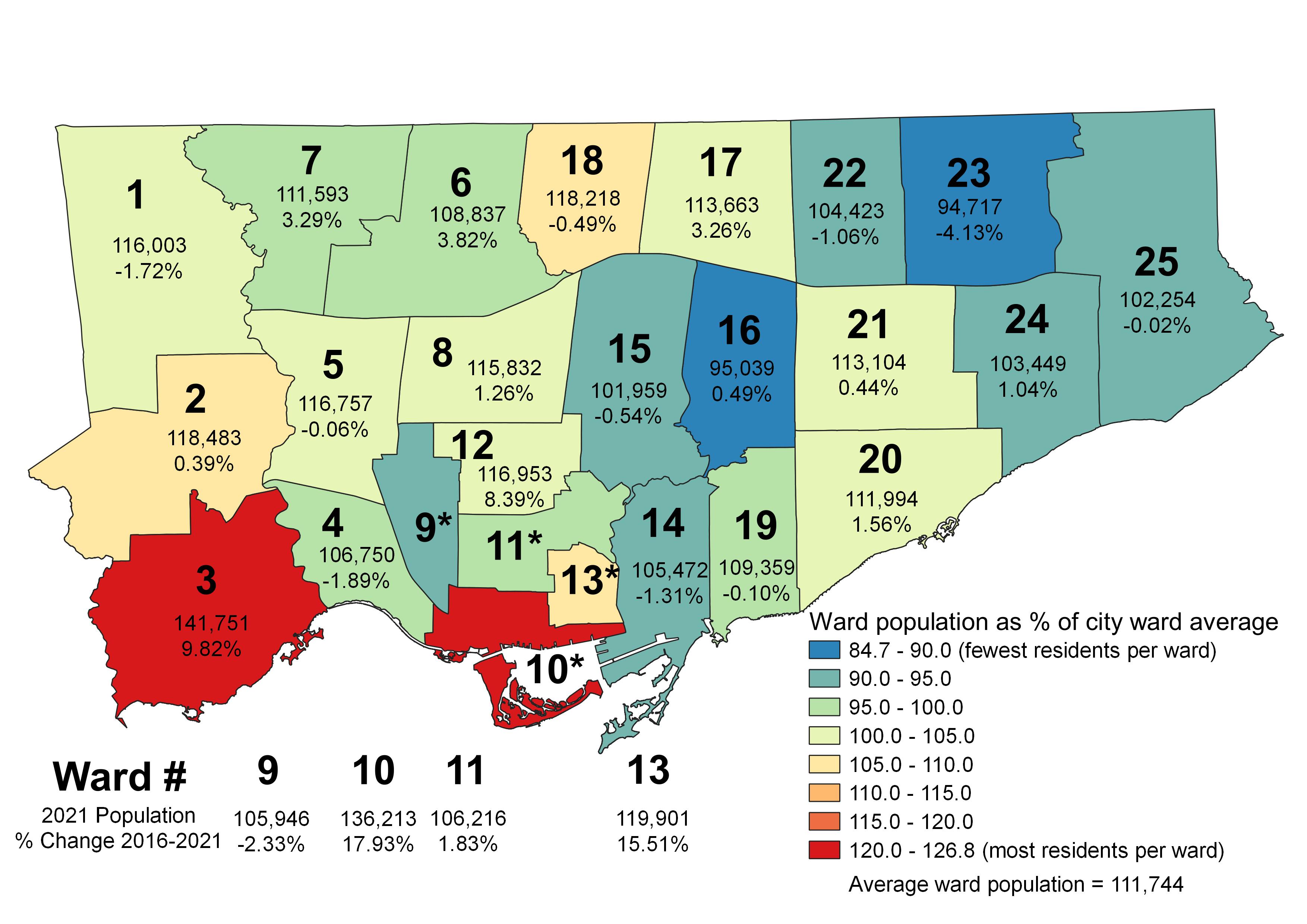
    By 2021, the population differences based on decade-old data became stark, as shown in the map below.

    Map depicting disparities in Toronto’s ward populations

    Ward 23 Scarborough North, represented by Cynthia Lai, has a population of 94,717. Ward 23’s population dropped by over 4% since 2016, as households age and few new housing units built in that ward. Ward 16, Don Valley East, has just 95,039 residents, with a stable population.

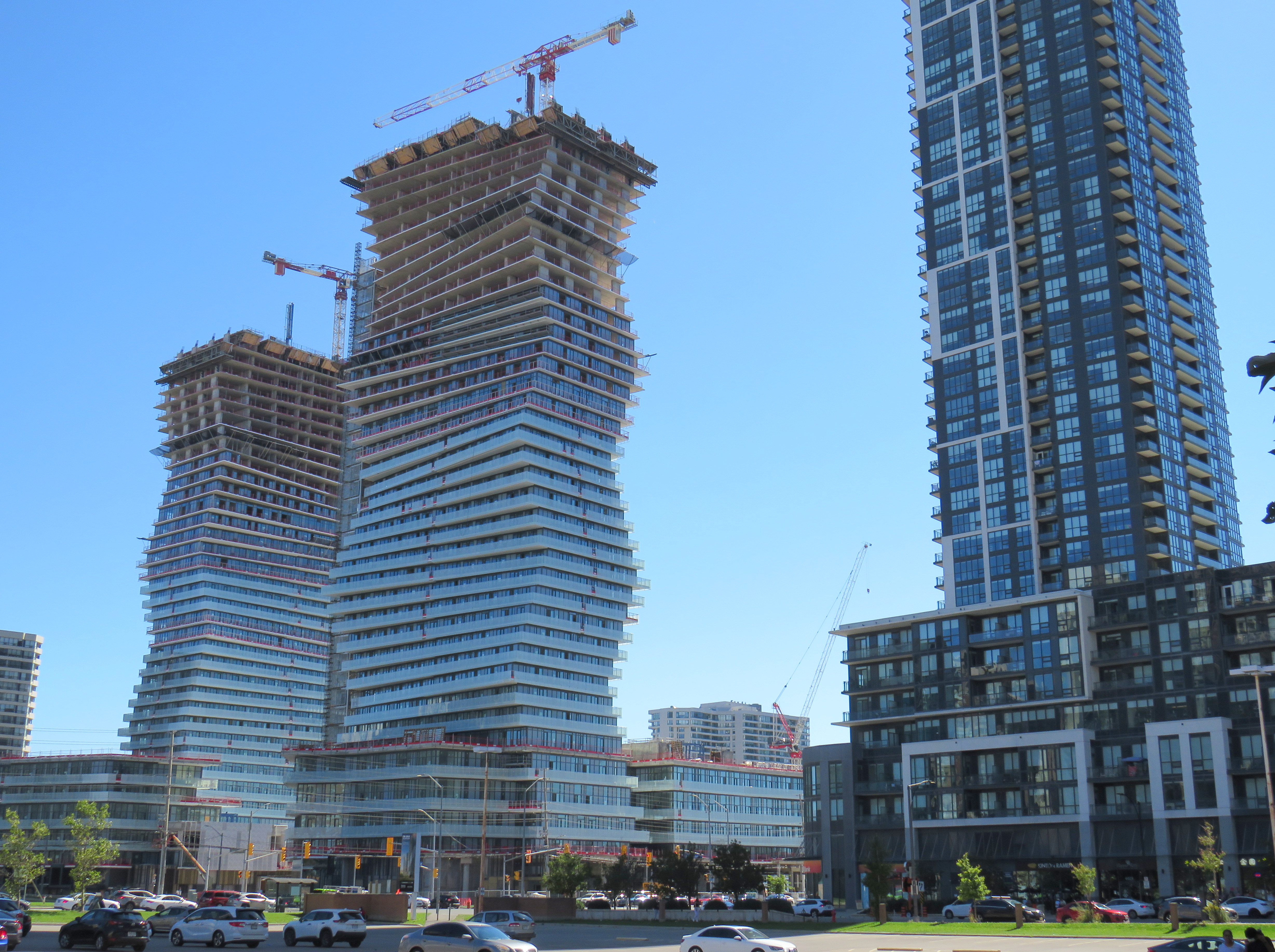
    On the other extreme, Ward 3 Etobicoke-Lakeshore, represented by veteran councillor Mark Grimes, has a population of 141,751, growing by 9.82% since 2016. New condominium developments in the Humber Bay neighbourhood and along the Queensway have driven much of that growth. Ward 10, Spadina-Fort York, saw an even greater number of new residents move in, growing by nearly 18% in the last five years.

    As Toronto is stuck with these ward boundaries until 2026, the population disparities will only grow larger, with downtown and South Etobicoke residents becoming even more underrepresented. Compounding the unfairness is that councillors representing high-growth wards have much higher workloads, as they deal with mountains of planning applications while ensuring their existing constituents have access to essential local services like schools, transit, and park space.

    The ward boundaries initially set for the 2018 municipal election would have accounted for future growth, ensuring that workloads would be more fairly distributed, and that city residents would have equal access to their local councillor.

    The 2021 population counts will be used to set new federal riding boundaries, which will be drawn next year after a consultation period and used in the first federal election held after 2023. The province will likely adopt the new boundaries for the 2026 election (assuming a majority government is elected in June).

    Perhaps in four years, Toronto will be able to set its own ward boundaries again. That, of course, will depend on electing a better provincial government and a council committed to equity and good governance.

  • Mapping Toronto’s population growth

    Despite new highrise development in its city centre, Mississauga lost 3,368 residents between 2016 and 2011

    On February 9, data geeks across Canada rejoiced when Statistics Canada released the first round of data from the 2021 Census of the Population.

    The data was released at all levels of geography made available by Statscan. At the federal level, Canada grew by 5.2% since the 2016 Census, with a total population of 36,991,981. Immigration, rather than natural growth (births vs. deaths) drove Canada’s population increase.

    Of course, this growth did not occur evenly across the country. Newfoundland and Labrador lost residents, while Prince Edward Island and British Columbia saw the biggest population increases.

    Within the Greater Toronto and Hamilton Area, Mississauga experienced population decline (-0.5%) for the first time since it became a city in 1974. Outer suburbs, such as Milton, East Gwillimbury, and areas just beyond the GTHA, such as New Tecumseth and Bradford saw population growth over 20%, driven by new greenfield development.

    In older Toronto suburbs, including much of Etobicoke, North York, Scarborough, and even Mississauga, population losses at the local census tract level can be explained by ageing households, where Millennial and older Gen Z children moved out on their own, particularly into fast-growing downtown areas. These areas, dominated by single-family housing, could accommodate much of the GTHA’s growth with gentle density, including secondary suites (such as basement apartments), garden suites, and zoning policies that would make it easier and more economical to build “missing middle” housing such as walkup apartments and multiplex homes.

    Toronto grew by 62,785 residents in the last five years, with only a few areas accommodating all that growth: the downtown core between Dufferin Street and Broadview Avenue, South Etobicoke, Yonge-Eglinton, and former industrial, instructional, and commercial lands stretching along the Highway 401 corridor through North York and West Scarborough. This corridor includes the Downsview Park development, a new condominium cluster at Wilson Subway Station, the former Canadian Tire lands near Sheppard Avenue and Leslie Street, and the intensification of the Fairview Mall area.

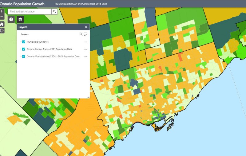
    You can take a look at the changes for each municipality and each census tract in Ontario with an interactive map I created here.

    Population Change for GTHA Municipalities

    Municipality2021 Population2016 PopulationChange (%)Change (Total)
    Toronto 2,794,3562,731,5712.362,785
    Mississauga717,961721,599-0.5-3,638
    Brampton656,480593,63810.662,842
    Hamilton569,353536,9176.032,436
    Markham338,503328,9662.99,537
    Vaughan323,103306,2336.016,870
    Oakville213,759193,83210.319,927
    Richmond Hill202,022195,0223.67,000
    Burlington186,948183,3142.03,634
    Oshawa175,383159,45810.015,925
    Whitby138,501128,3777.910,124
    Milton132,979110,12820.722,851
    Ajax126,666119,6775.86,989
    Clarington101,42792,01310.29,414
    Pickering99,18691,7718.17,415
    Newmarket87,94284,2244.43,718
    Caledon76,58166,50215.210,079
    Halton Hills62,95161,1612.91,790
    Aurora62,05755,44511.96,612
    Whitchurch-Stouffville49,86445,8378.84,027
    Georgina47,64245,4184.92,224
    East Gwillimbury34,63723,99144.410,646
    King27,33324,51211.52,821
    Scugog21,58121,617-0.2-36
    Uxbridge21,55621,1761.8380
    Brock12,56711,6427.9925

  • The TTC, by the numbers

    The TTC, by the numbers

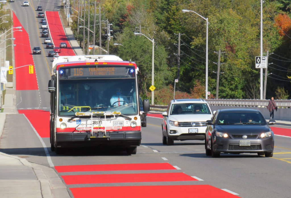
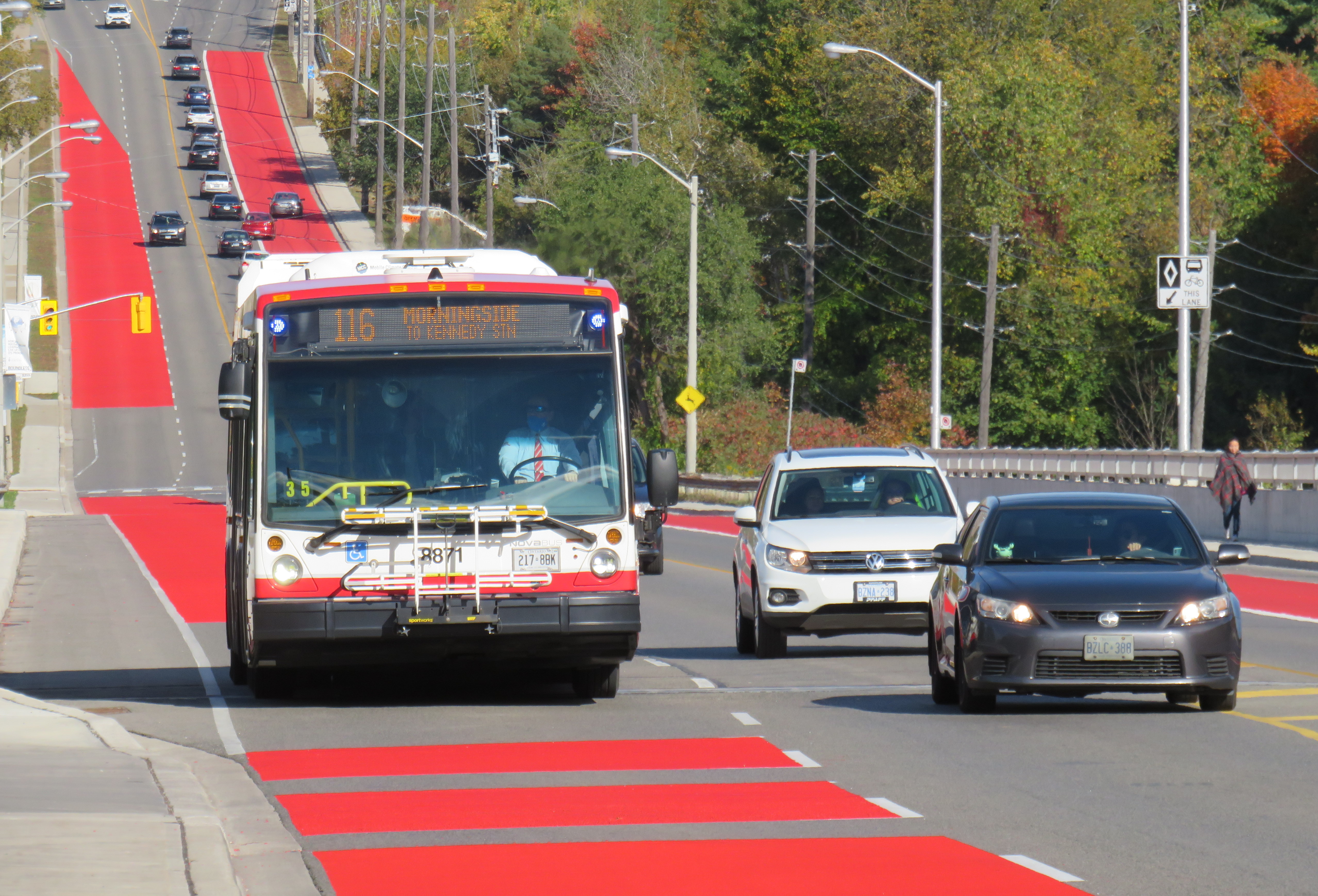
    Route 116 Morningside was created in 1989, replacing a branch of Route 34 Eglinton East

    On Sunday, June 20, the TTC will renumber two bus routes, Route 5 Avenue Road and 6 Bay. This change comes ahead of the opening of the Crosstown LRT and the Finch West LRT, which will be assigned those numbers, as they added to the city’s rapid transit network in the next few years.

    Route 5 Avenue Road, in service since 1954, will become Route 13 Avenue Road. 6 Bay, which has existed since 1963, will be renumbered 19 Bay. Those follow similar measures in 2001, when the 2 Anglesey and 4 Annette routes were renamed to 48 Rathburn and 26 Dupont, respectively.

    Though there are over 150 bus routes operated by the TTC, including express routes and all-night routes, the TTC was relatively late numbering all of its services. A consistent system for numbering bus routes did not exist until the late 1950s (though they did not appear on system maps until 1964), while streetcar lines were not assigned numbers until 1979.

    Later, new series of route numbers were assigned to the overnight “Blue Night” network in the late 1980s, rapid transit lines in 2001 (just prior to the Sheppard Subway’s opening), and express bus routes only a few years ago. But for the regular service lines (those between 7 and 189), the numbers seem random — not grouped by geography, service type, or year each route was established.

    In the late 1950s, though, when bus routes were numbered for the first time in 30 years, there was a system: numbers would be assigned in alphabetical order, with north-south routes given odd numbers, and east-west routes assigned even numbers.

    Bus on Route 34 Eglinton East, in the late 1950s.
    City of Toronto Archives Series 648, File 29, Item 1.

    Route 1, Armour Heights, was a short shuttle that ran along Avenue Road between the fare zone boundary at Roe Avenue (the end of the frequent 61 Nortown trolley coach) and Bombay Avenue, north of Highway 401. Route 2 Anglesey served several neighbourhoods in central Etobicoke. Route 96 Wilson remains a busy east-west route in North York, and Route 97 Yonge was originally a very frequent trolley coach route between the north end of the subway at Eglinton Station and the City of Toronto limits at Glen Echo Loop.

    In 1964, the numbering system was still mostly intact, with two notable exceptions: 6 Bay, introduced one year earlier in 1963, was a north-south route. Route 17 Birchmount, introduced in 1960, broke the alphabetical order after Route 15 Brimley.

    The opening of the Bloor-Danforth Subway in 1966 and major extensions in 1968 resulted in major route restructurings, and while the TTC tried to maintain the odd numbers for north-south routes and even numbers for east-west routes, that eventually came to an end, especially when further expansion required the use of three-digit numbers in the mid 1970s.

    The interactive map below shows the full extent of the TTC’s service area in 1964, along with the municipal boundaries of that era, before Metro went from thirteen cities, towns, and townships to just six.

    Link to interactive map

    Though today’s regular service bus route numbers do not follow a specific pattern, recent changes to the night bus and express bus numbering systems have restored order to the numbering scheme.

    Number Route Type
    1-6Rapid transit lines (subway, LRT).
    7-189Regular local bus service
    300-396Night bus and streetcar routes, with numbers often echoing the daytime service (for instance, 329 Dufferin night buses follows the daytime 29 Dufferin bus’s route)
    400-407Community buses, offering ultra-local accessible services in selected parts of the city.
    501-512Streetcar routes. Streetcar route numbers were introduced in 1979, coincident with the introduction of the CLRV streetcars. The small area for destination signs in the new vehicles required numbers to be displayed instead of names for information to be legible.
    600-699Subway operations, internal use only. Previously, rapid transit routes were numbered in the 600-series, with Yonge-University-Spadina numbered 601, Bloor-Danforth 602, and Scarborough RT 603. Briefly, the Harbourfront Streetcar was branded as a rapid transit route and assigned number 604.
    900-996Express network bus routes, with numbers often echoing the regular service (for instance, 996 Wilson Express follows the local 96 Wilson bus’s route)