Last month, I wrote about the challenges getting around Toronto’s Union Station, Canada’s busiest transportation hub, particularly for passengers using mobility devices or carrying luggage. Only one poorly-marked elevator directly links the Great Hall and the UP Express platform with the subway station/PATH level, which is located two floors down.
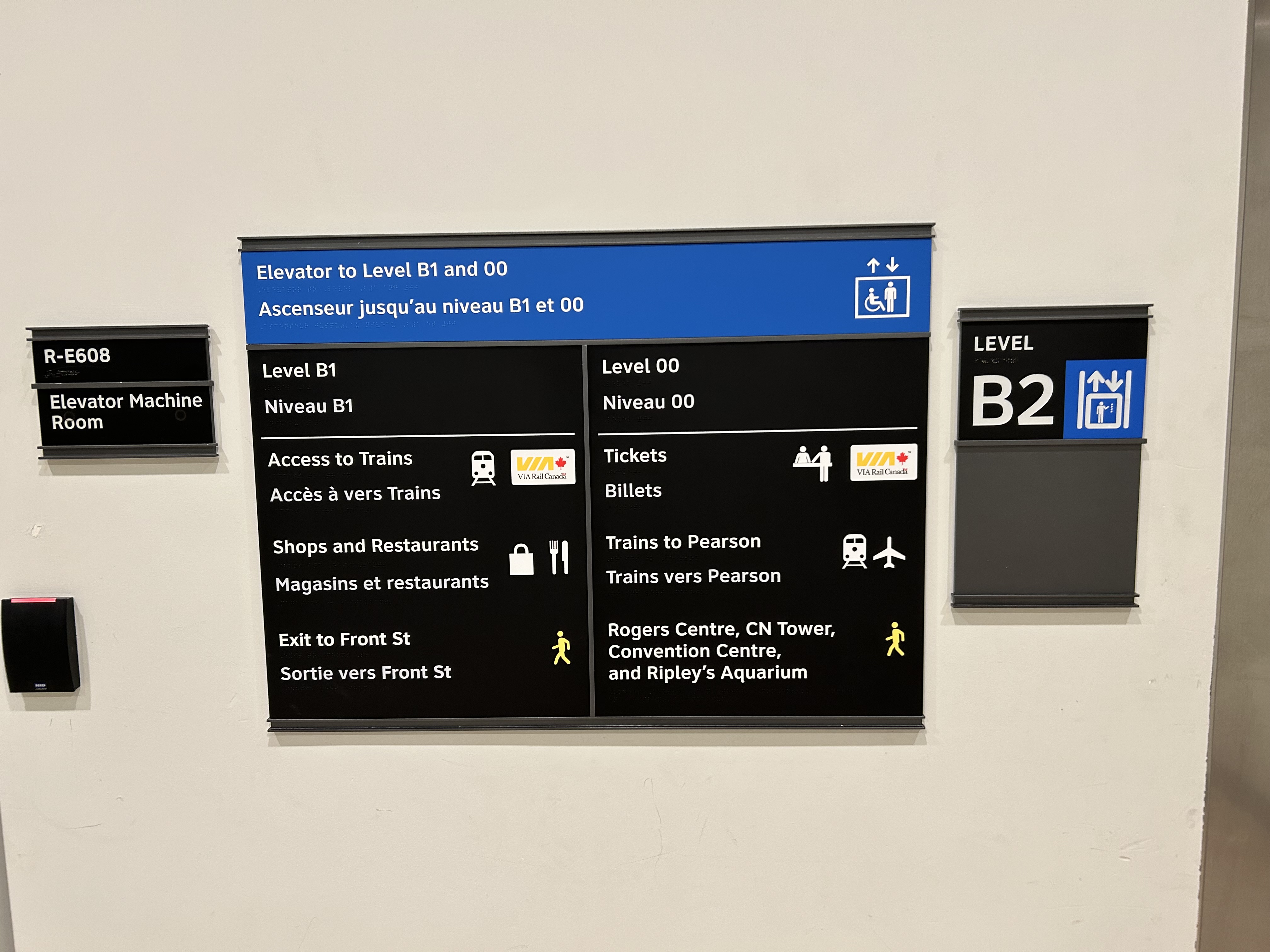
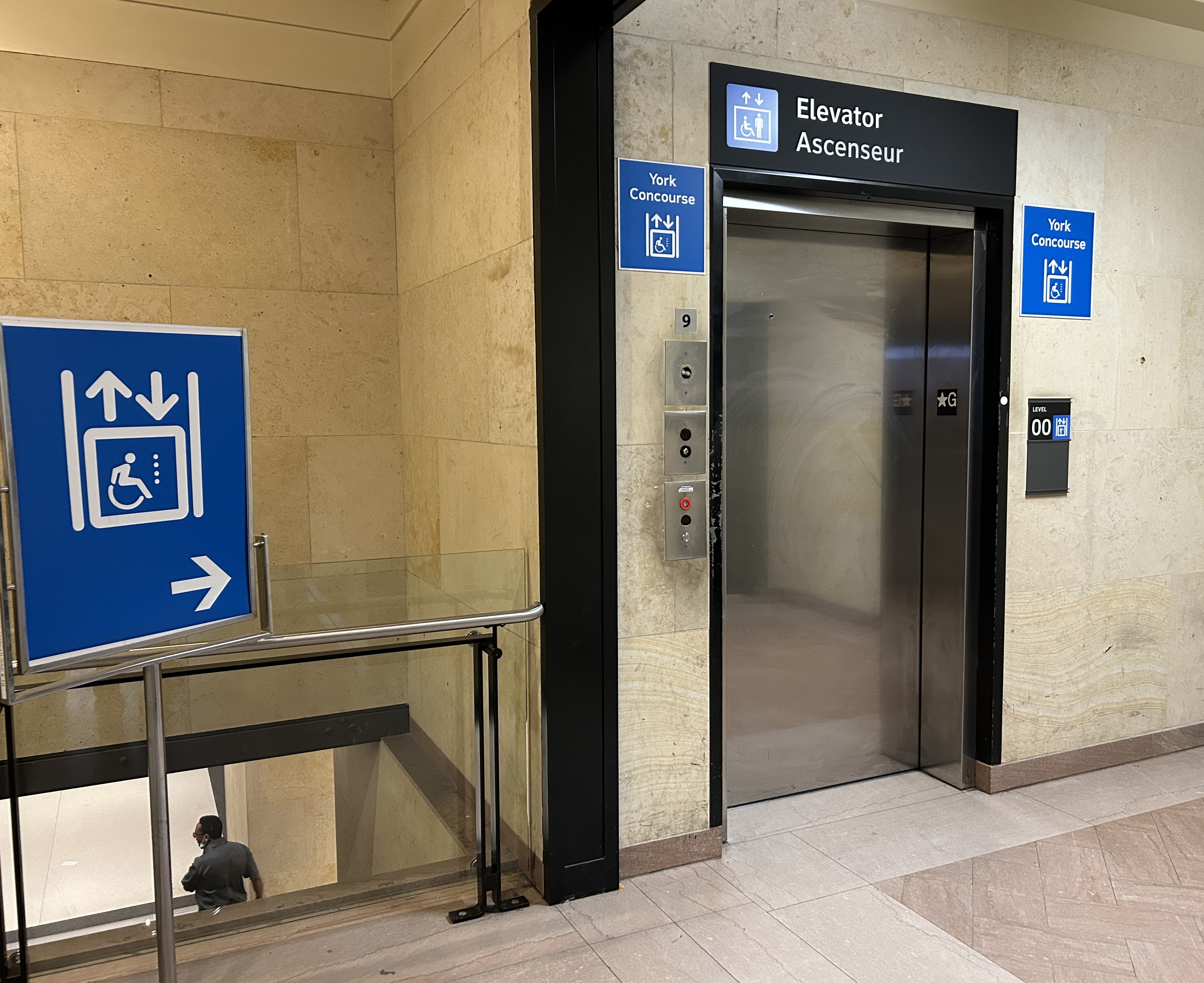
I returned to Union Station on Tuesday, January 7, to see if any improvements were made since I wrote my initial post. Somewhat surprisingly, new signs were installed beside the elevators, indicating which floor goes where.
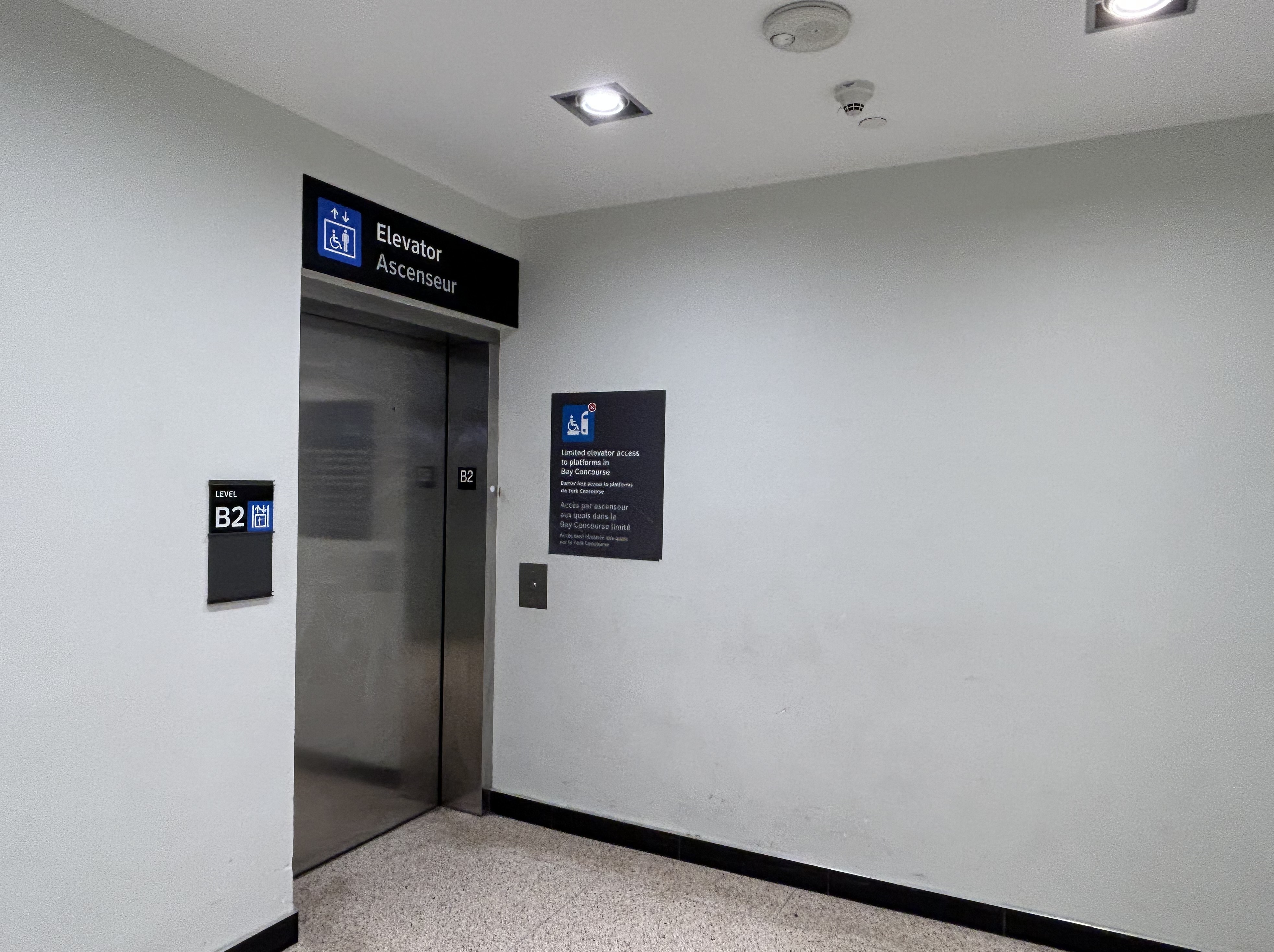
Elevator signage at B2 level (subway concourse/PATH level by Bay Street) that indicates where the other floors lead to: Level B1 for VIA trains, shops and restaurants, and exit to Front Street, and Level 00 for VIA ticketing, UP Express trains, and access to the Skywalk to Rogers Centre, CN Tower et al.In the GO York Concourse, the elevator leads to Level 00 (The Great Hall) only.
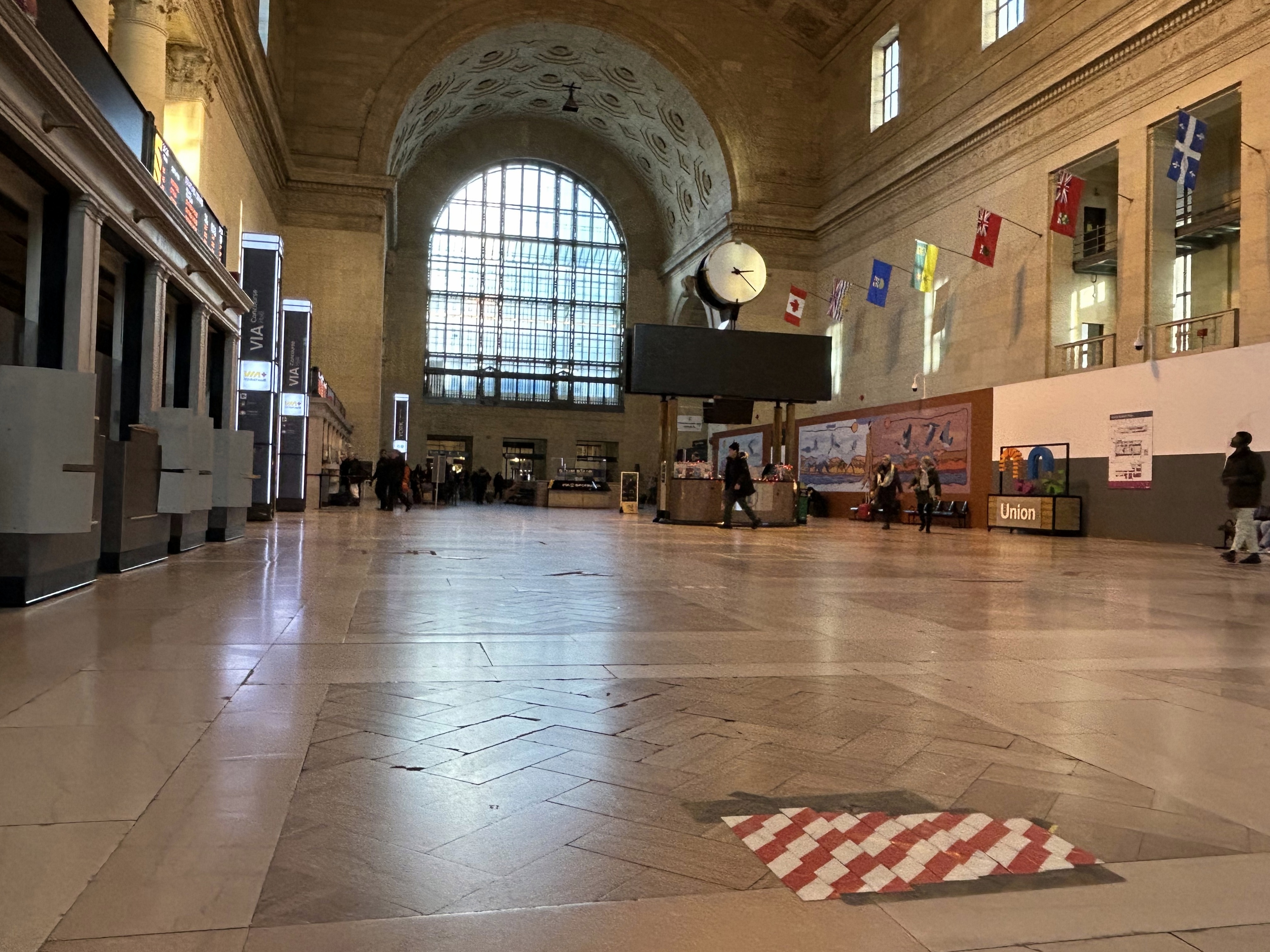
These signs are a notable improvement, but there is still no signage inside the elevator cars themselves, so the traveler must note the directory signage before entering the elevator. Furthermore, the Great Hall, the historic centrepiece of the Union Station complex, is not noted, even though it is a logical meeting place from where access to all GO, VIA, and UP Express train services can be made, or where taxis can be found right outside.
Unfortunately, the elevators themselves are still difficult to locate, and the decision to have just one slow elevator connect the Great Hall/UP Express floor with the subway station entrance remains unfortunate. There is still so much more to be done.
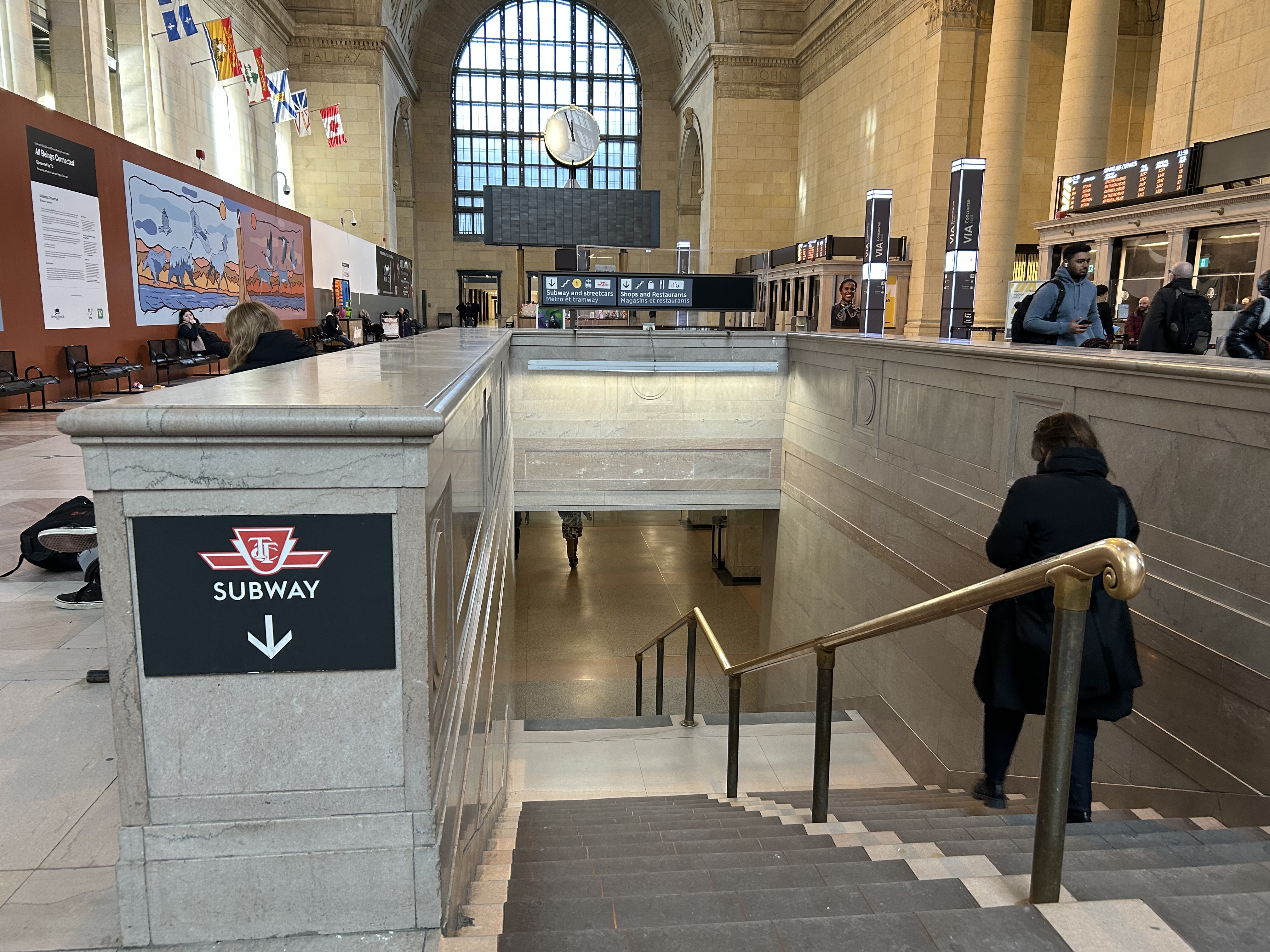
In the Great Hall, there are clear signs directing passengers towards the subway, but there are no indications on where a barrier-free passage can be found. A supplementary sign pointing towards the one elevator, located at the far end of the Great Hall, could be useful here.
Previously on this website, I discussed the problems with the unsightly, intrusive, and poorly thought-out mess of Jersey barriers plopped in front of Union Station along Front Street. They have not only been an eyesore unbefitting a signature heritage structure, but they have also been difficult for pedestrians to navigate around, especially at the corners of Front and Bay and Front and York.
Inside Union Station, however, a lot has changed in the last few years. In general, pedestrian flow within the station building has improved, especially with the opening of the GO Transit York Concourse, which provides a second access point for regional trains. Flow between subway, train, and shops is considerably improved; there are also a lot more food and retail options befitting a central transport hub.
Despite new escalators and elevators, accessibility in Union Station remains poor. Though technically, the station is fully accessible to anyone using a wheelchair or other mobility device, the wayfinding is absent in key areas. There is only one small elevator that directly connects the subway level with the Great Hall, UP Express trains, and Front Street. An accessible route is also difficult to find.
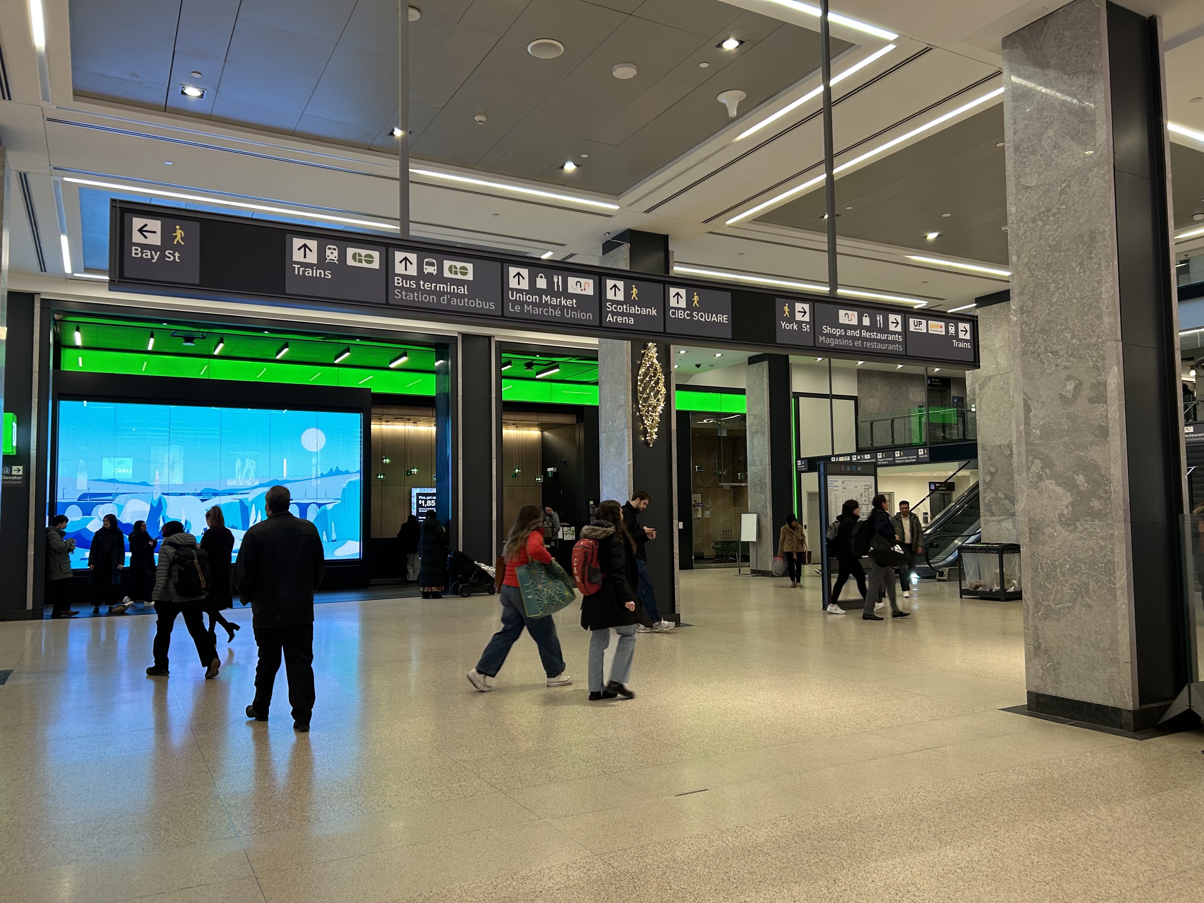
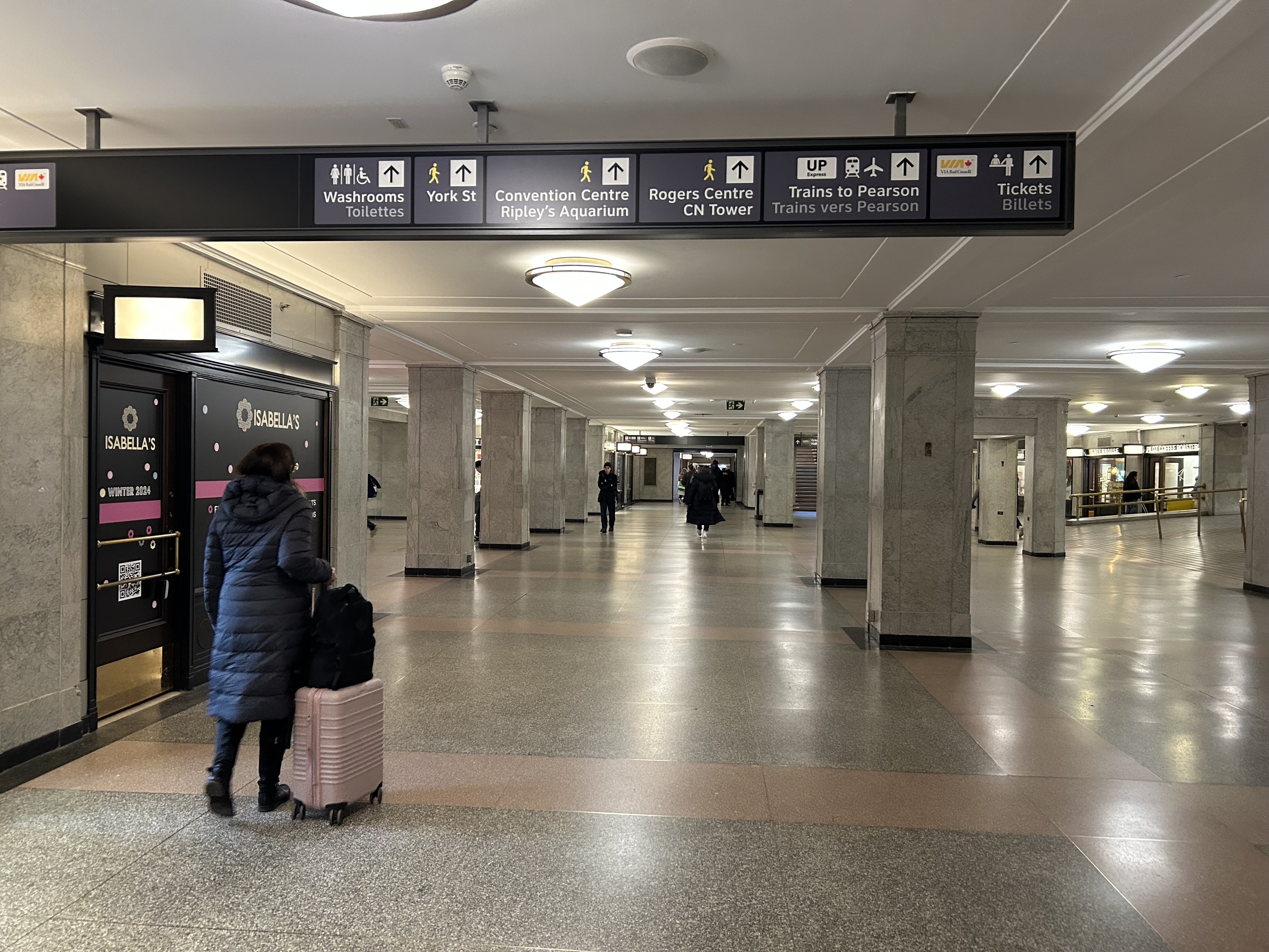
The view after entering the Union Station complex from the TTC subway. The overhead sign shows the way to GO trains, the bus terminal, the Union Market shopping area, Scotiabank Arena, CIBC Square (an office building), York Street, more shops and restaurants, and VIA and UP Express trains.
Imagine entering Union Station from the adjacent TTC subway station with a wheeled device or a mobility aid. There is a large concourse with signs leading forward towards the GO Transit York Concourse along with Scotiabank Arena, the bus terminal, and Union Station shops and food kiosks. To the left is Bay Street, and to the right are a set of escalators and stairs leading up towards VIA Rail and UP Express trains. Behind the stairs and escalators is a single elevator, hidden away.
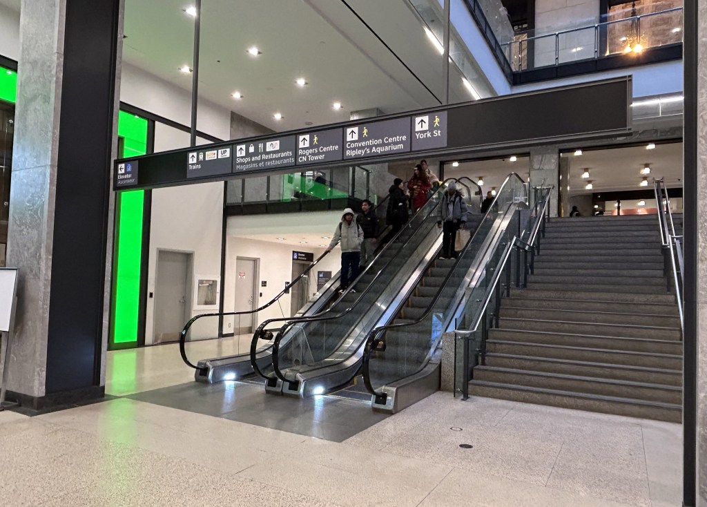
To the right is a set of escalators, stairs, and hidden behind, a poorly marked single elevator.These lead towards UP Express and VIA trains, York Street, and attractions such as the CN Tower, the Convention Centre, and Rogers Centre.
The elevator provides no information other than a sign that indicates that this is, in fact, an elevator, and this is the B2 level. This is a single, small elevator, which operates slowly.
The elevator at the B2 (subway) level
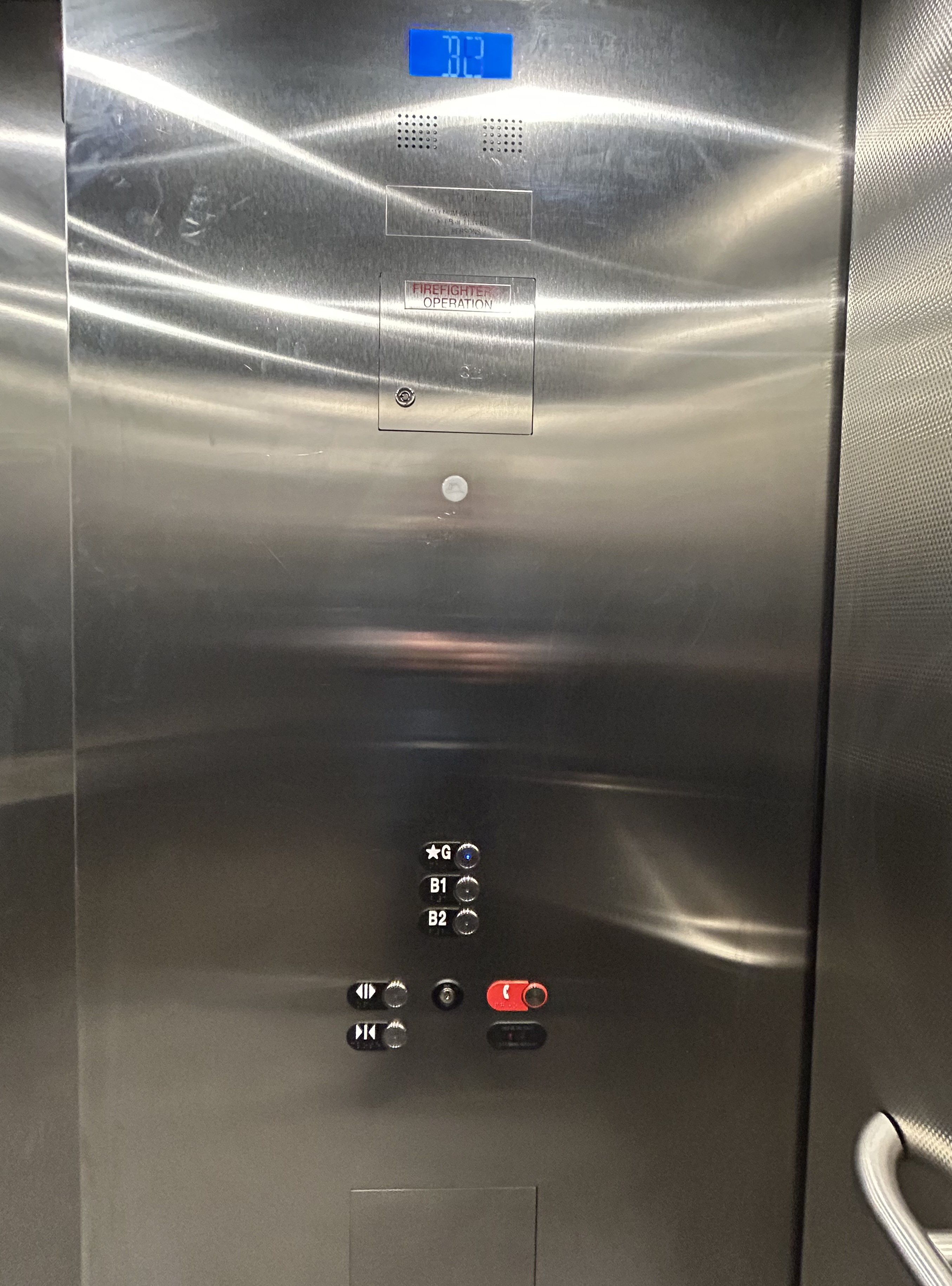
Once inside the elevator, there is no information other than buttons marked “G”, “B1”, and “B2”. There is nothing to tell the elevator user what is accessible from each floor.
Confusingly, the official Union Station map directory calls the three levels “Street Level” (G, the Heritage structure including the Great Hall, West and East Wings, along with the path towards UP Express and the Skywalk), “Lower Level” (B1, the GO York and Bay Concourses, the concourse beneath the Great Hall, and the VIA departure area) and “Retail Level” (B2, including the food court, food hall, and connections to the subway). In the elevators, the audio prompts only mention the three level names.
Inside the elevators, there is no indication what each level is, or where they lead to — the buttons and empty spaces beside them just show G, B1, and B2 levels
At G level, which includes the Great Hall, VIA Rail departures and business class lounge, and the passage west towards UP Express trains and the Skywalk to the CN Tower and Rogers Centre, the elevator is also hidden behind a wall.
The only elevator connecting the Great Hall, the lower concourse, and the subway level is hidden, with tiny signage directing travelers to it
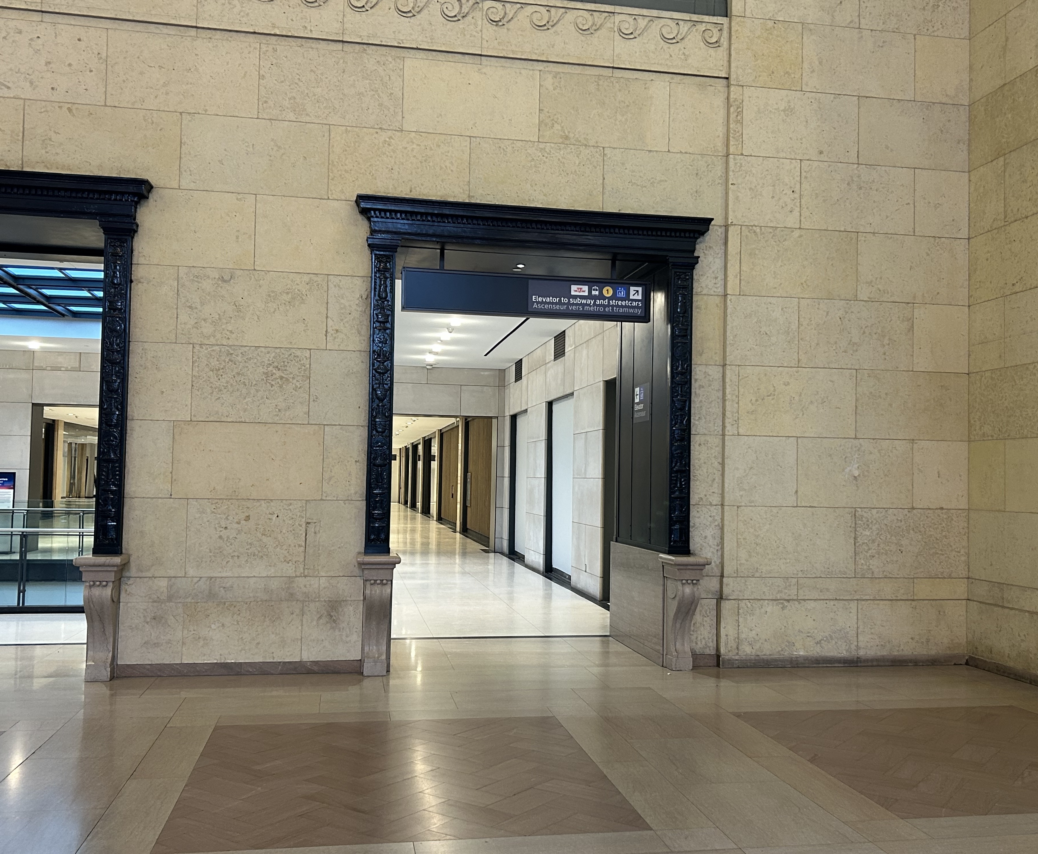
On the west side of The Great Hall, there is also an elevator, beside the stairway down to the GO Transit York Concourse. This elevator does not serve level B2.
York Concourse elevator, on the west side of Union Station’s Great Hall
If the traveler was only connecting from subway to UP Express with a heavy bag, and not using a mobility device, they might decide to take an escalator from the subway B2 level to the B1 level, the lower Union Station concourse originally intended as an arrivals area for intercity trains. However, there is no elevator or upwards escalator to be seen.
Looking west in the lower concourse, towards York Street and UP Express trains
If one knew Union Station well, they could make a lengthy detour through the ramps in the VIA Rail area to get to the Great Hall or go around through the GO York Concourse to reach the elevator or up escalator to the Great Hall. But these routes are not marked from the lower concourse area.
To show how difficult it can be to navigate the station while using a wheeled device (be it a wheelchair, stroller, or wheeled luggage), I shot this video showing how a first-time visitor getting off an UP Express train from Union Station would try to find the TTC subway entrance.
Video depicting 9-minute trip at a normal walking speed between the UP Express area and TTC subway station entrance, using first available elevators each time.
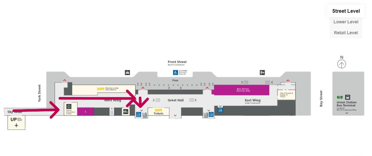
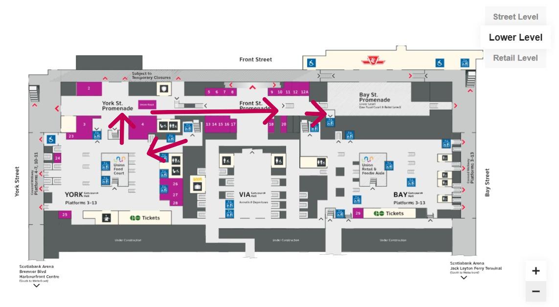
At no point was there any visible signage showing the most direct route for someone requiring a barrier-free path from UP Express to the subway. The maps below show the route I took:
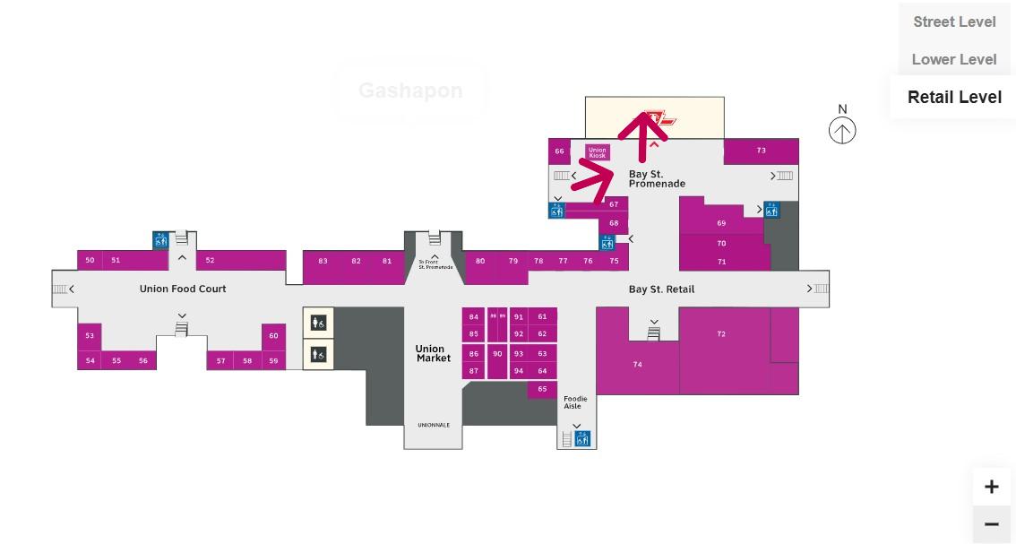
Route from UP Express to the Great Hall and York Concourse Elevator (Street Level, or G). Arrows are added to mark the route I took in the video.Path through York Concourse, lower Union Station concourse (Front St. Promenade) – the B1 Level, and to the second elevator to the Bay St. Promenade (subway level). Arrows are added to mark the route I took in the video.Last part of the trip on the Retail Level (B2) to the subway station entrance. Arrows are added to mark the route I took in the video.
Whenever I travel through an international airport — Toronto Pearson is a good example — I never have to think too hard about where the accessible routes are. Escalators are easy to find. There are banks of two or three large elevators in strategic locations on the ground side of airports, connecting departure and arrival areas, as well as ground transportation facilities. As Canada’s busiest transport hub — busier than Toronto Pearson Airport even — Union Station’s elevators and escalators should be plentiful and easy to find.
I am aware that there are particular challenges at Toronto Union Station — the City of Toronto controls only the common areas, such as the Great Hall, the retail areas, and the main entrances. Metrolinx, the agency responsible for GO Transit and UP Express, controls the York and Bay Concourses, as well as the UP Express station area. VIA Rail maintains its departures area. There are also heritage elements that need to remain intact, such as the Great Hall. But these issues of ownership and heritage preservation do not excuse the difficulty of getting around with a mobility device or even a wheeled bag.
Why weren’t multiple elevators installed connecting all three levels, to improve capacity, speed, and provide redundancy in the case of an elevator outage? Why are there not easy-to-find elevators in the West Wing near the UP Express area?
Judging by the condition of the signature Great Hall itself, there is work yet to be done before Union Station is fully restored to its 1920s grandeur. It should not be too hard to improve accessibility and wayfinding as well. Not just for Torontonians, but for international travelers too.
The Great Hall floor is still cracked and patched, with electrical tape covering some of the damaged sections
In mid-November, I found myself in Washington DC, accompanying my spouse as she had multiple days of work-related meetings. While I spent part of my time visiting cities in Delaware, Maryland, and Virginia, I also visited several neighbourhoods in Washington itself. Among the things I wanted to see for the first time was the D.C. Streetcar, one of nearly a dozen systems built across the United States in the last two decades. I had already taken rides on modern streetcars in Atlanta, Detroit, Kansas City, Cincinnati, as well as Portland and Seattle, coming away mostly unimpressed — though Portland, Detroit, and Kansas City show some promise. Washington’s small implementation didn’t win me over either.
I grew up in Brampton, a suburb of a city that maintained a large legacy streetcar fleet. Growing up, I thought streetcars were the greatest thing: big, smooth, quiet, gliding through some of Toronto’s most interesting neighbourhoods. I watched as the city expanded its street railway network along the waterfront and up Spadina Avenue before I had the opportunity to move to the big city.
Living in Toronto, and reliant on the streetcars, I got to experience the highs and the lows of street railway operation: traffic congestion, bunching, diversions, bustitutions, but also the sweet late-night rides when the streetcar really felt like the king of the road. The new low-floor Flexity streetcars brought even larger vehicles, but they were subject to the same constraints as the smaller CLRVs.
The TTC’s indifference to line management and the insistence on slow operation in the name of safety (without actually addressing problems like obsolete switches) made streetcar travel less magical with every passing year. But in Toronto, streetcars are still a workhorse, and there is still no easy way for buses to permanently substitute for the demand on routes like King Street.
Visiting cities elsewhere in the world, like Viennaor Hiroshima, makes me realize that trams can and should work, something that Toronto has largely forgotten. Or something that American cities rediscovering the streetcar haven’t even figured out.
Former D.C. Transit streetcar in the distinctive 1956-1962 Trans Caribbean Airlines colour scheme, at Seashore Trolley Museum in Maine
Like all large American cities, Washington once had a robust streetcar network, with several private operators that consolidated into Capital Transit in 1933. Streetcars extended throughout the District and into Maryland suburbs, with separate companies providing service into Virginia’s sprawling suburbs until 1941.
Within central Washington, streetcars were required by law to draw electric power from an underground conduit for aesthetic reasons, though outlying areas did not have this this obligation. Therefore, many streetcars in DC, including the modern PCC streetcars acquired in the 1930s and 1940s, had both overhead trolley poles and underbody current collectors.
The last streetcar line in DC was abandoned in January 1962. Fourteen years later, the first section of the Washington Metro opened for service. Unlike the streetcars, the new Metro system was more of a regional service, reaching far out into the Maryland and Virginia suburbs. (Famously, the affluent and congested Georgetown area of Washington is not served by Metro, which was designed mainly as a commuter service.) Though bus service was consolidated throughout the region, there were parts of Washington left underserved by Metro and local bus. The District government began operating its own bus service, DC Connector, and began planning new streetcar services to serve traditionally underserved and rejuvenating neighbourhoods.
Map of the proposed Phase I streetcar network. Only the thick red line was completed.
The first planned route would have connected Anacostia, a historic neighbourhood with a majority Black population, with the Metro and with the gentrifying Navy Yards district on the north side of the Anacostia River. At first, the new light rail would have followed a disused CSX freight spur line, but disagreements with the railroad and land title issues changed the route to a shorter, on-street alignment. After several false starts, work started in 2009 on a “demonstration line” between Anacostia Metro Station and Joint Base Anacostia–Bolling, a major military installation, with an extension to Minnesota Metro Station to follow.
Looking east on Firth Sterling Ave SE with the tracks suddenly ending before Suitland Parkway. The abandoned CSX spur line right-of-way is on the right.
Work was suspended indefinitely in 2010. Today, less than a mile of track remains abandoned in place.
Looking west on Firth Sterling Ave SE toward Joint Base Anacostia–Bolling, where curb-side streetcar tracks installed in 2009-2010 are left abandoned
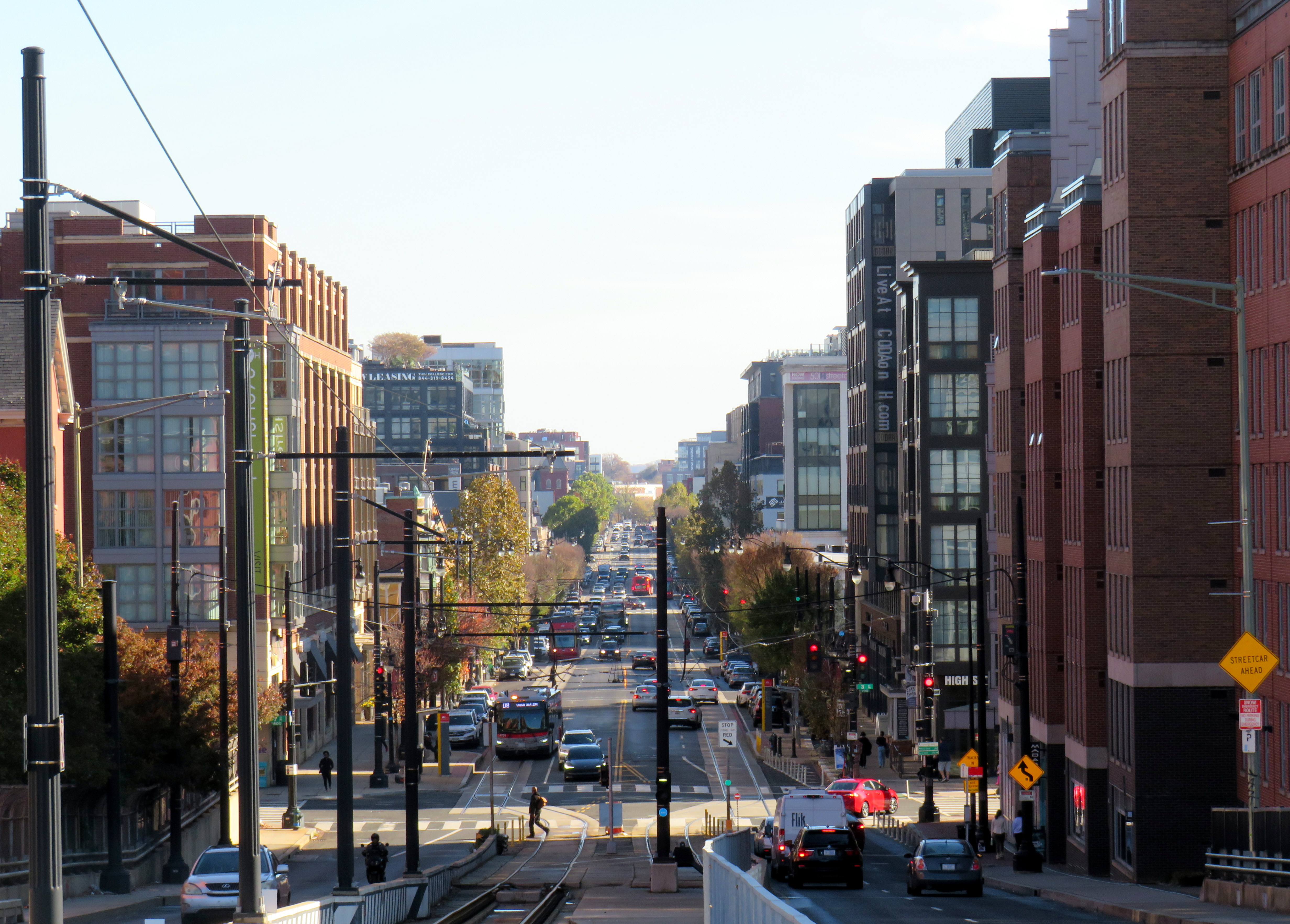
An abbreviated 2.4 mile (3.9 km) H Street-Benning Road Line did open, however, in 2016, several years late. The route, which begins on the H Street overpass north of Union Station, extends east to Oklahoma Avenue, at a public park and sports complex north of the abandoned RFK Stadium. Service, which is currently fare-free, operates every 12 minutes during daytime hours. A parallel bus route, the X2 Benning Road–H Street Line, operates as frequently, but has a much longer route and is considerably faster.
H Street, in the city’s east side, has long been a lower-income, majority Black neighbourhood, hit hard by disinvestment, civil unrest (especially after the assassination of Dr. Martin Luther King Jr. in 1968), crime, and depressed property values. But its proximity to the governmental, cultural, and commercial centres of the city made it an attractive corridor for redevelopment.
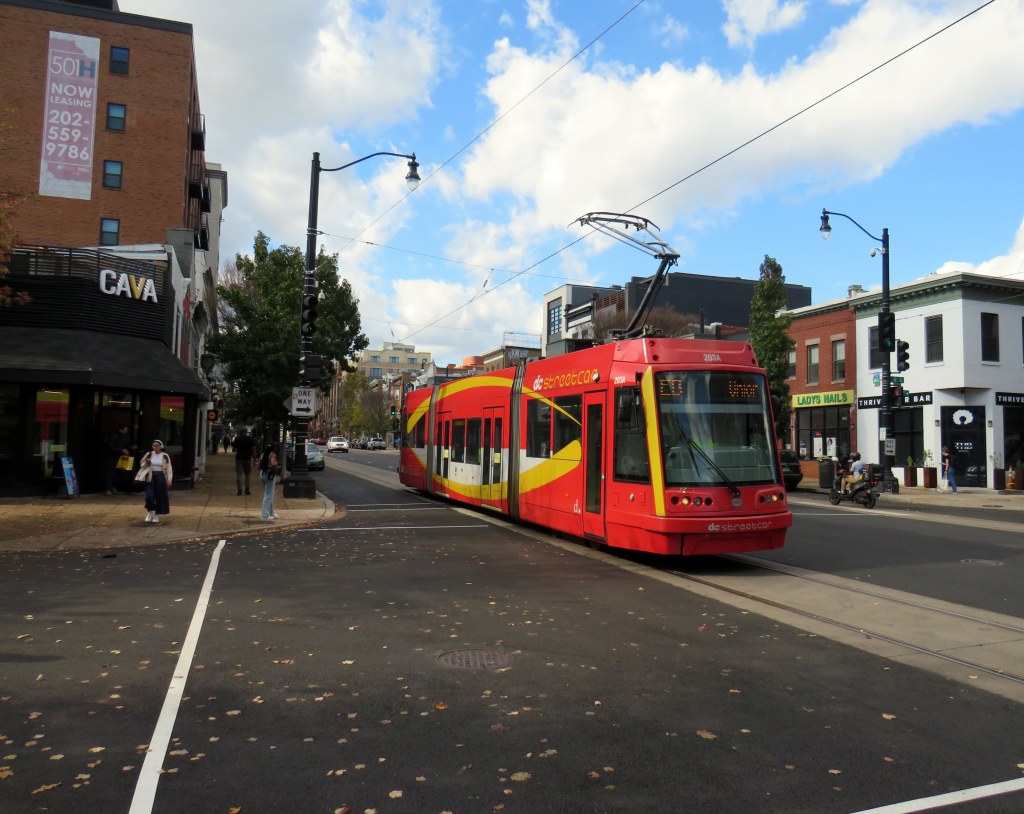
A westbound streetcar shifts into the median on H Street on the way to Union Station
Though Union Station is the western terminus of the short streetcar line, the connection to the Metro Red Line, Amtrak, MARC, and VRE trains is awkward. H Street is to the north of Union Station, crossing over the multitude of tracks leading into the station platforms on a long overpass. The streetcar stops halfway across, in the median. Passengers getting off the streetcar must walk further west on the median, then cross the eastbound lanes of H Street at a traffic signal controlling a driveway exit from the Union Station parking garage. A poorly marked sidewalk provides the connection into the parking garage (which also houses the Union Station intercity bus terminal) and down towards the main station building.
The path from DC Streetcar, through a parking garage, towards Union Station
Like most modern streetcar lines in the United States, the DC Streetcar runs in mixed traffic, in the outer driving lane. This allows for platform level boarding from the sidewalk at each stop, but it also leaves the streetcar susceptible to traffic delays due to congestion and from stopped cars and trucks. Though there are parking and layby spaces to the right of the streetcar track, a wide or improperly stopped vehicle can easily disrupt service. Streetcars regularly squeeze past properly parked delivery vans, as in the photo below.
A streetcar squeezes past a stopped Amazon delivery van on H Street
But new streetcar lines in North America are typically less about moving people than it is about sparking new urban development. On H Street, this has definitely happened. New mid-rise rental and condominium residential buildings line the western end, towards Union Station. A Whole Foods grocery store is at the base of one of those buildings, where previously, there was a parking lot and local grocery store.
Streetcar passes a Whole Foods grocery store at the base of a mew seven-storey rental apartment building, northeast corner of H Street and 6th Street NEThe same corner in 2008, with a neighbourhood grocery store on the northeast corner of H Street and 6th Street NE(Google Streetview)
Still, I wonder how much the streetcar itself contributed to the gentrification of H Street. The streetscape is greatly improved, but streetcar ridership is low, despite the free fare. The close proximity to Union Station, government offices, and commercial areas, along with rezoning of vacant lots would have made a bigger impact. However, government investment on the corridor made it attractive for speculators and developers to assemble land and build.
In the meantime, as rents skyrocket, crime remains a concern. New stores such as Whole Foods do not serve long-term residents and local businesses have been displaced. Like Whole Foods, the streetcar was designed to support the new community, while others continue to take the bus and shop at the Safeway on Benning Road.
Looking east at H Street and 3rd Street, 2008 (Google Streetview)Looking east towards 3rd Street, November 2024
If the H Street-Benning Road Streetcar was extended in both directions based on the original plans, it could prove to be a useful, albeit slow, transit service filling in one of the gaps left by the Washington Metro system. But as Washington struggles with its city budget, this is very unlikely. By the end of the year, the DC Circulator bus system will disappear for good, further orphaning the single short streetcar line operated by the District.
There are buses to more destinations in 2024, but a few major gaps persist
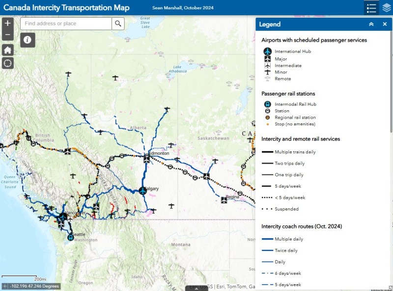
NOTE: Previous versions of the Ontario and Canada maps are retired; please see the new Canada Intercity Transport Map, launched March 30, 2025. This will now be the only interactive map that I will update.
Unfortunately, outside of Ontario, there not that many updates to make. On Vancouver Island, at least, there is now daily service all the way to Port Hardy in the north and Tofino and Ucluelet to the west, with additional runs between Comox, Nanaimo, and Victoria. There are more buses between Vancouver and Seattle; FlixBus is now operating on the busy Calgary-Edmonton and Calgary-Banff routes. There is also a new twice-weekly Edmonton-Camrose service, thanks to work by the University of Alberta’s student union; it partnered with FlixBus to provide the service.
Also new to the map is Mountain Man Mike’s bus service between Vancouver, Nelson, Kaslo BC, and Calgary, as well as Mobilité Charlevoix, a regional service that connects several towns east of Québec City including Baie-Saint-Paul, La Malbaie, and Clermont.
Unfortunately, several wide gaps remain. Despite plenty of competition on the busiest routes in Southern Ontario and Alberta, there is no bus service between Calgary and Regina, leaving cities like Medicine Hat and Moose Jaw without intercity connections, apart from airport shuttle services, despite once-frequent Greyhound service. Between Winnipeg and Regina, it is still just one bus a week. Maritime Bus, for whatever reason, still has not restored service across the New Brunswick-Québec provincial line.
Without comprehensive government-led coordination and support, these gaps are likely to remain unfilled.
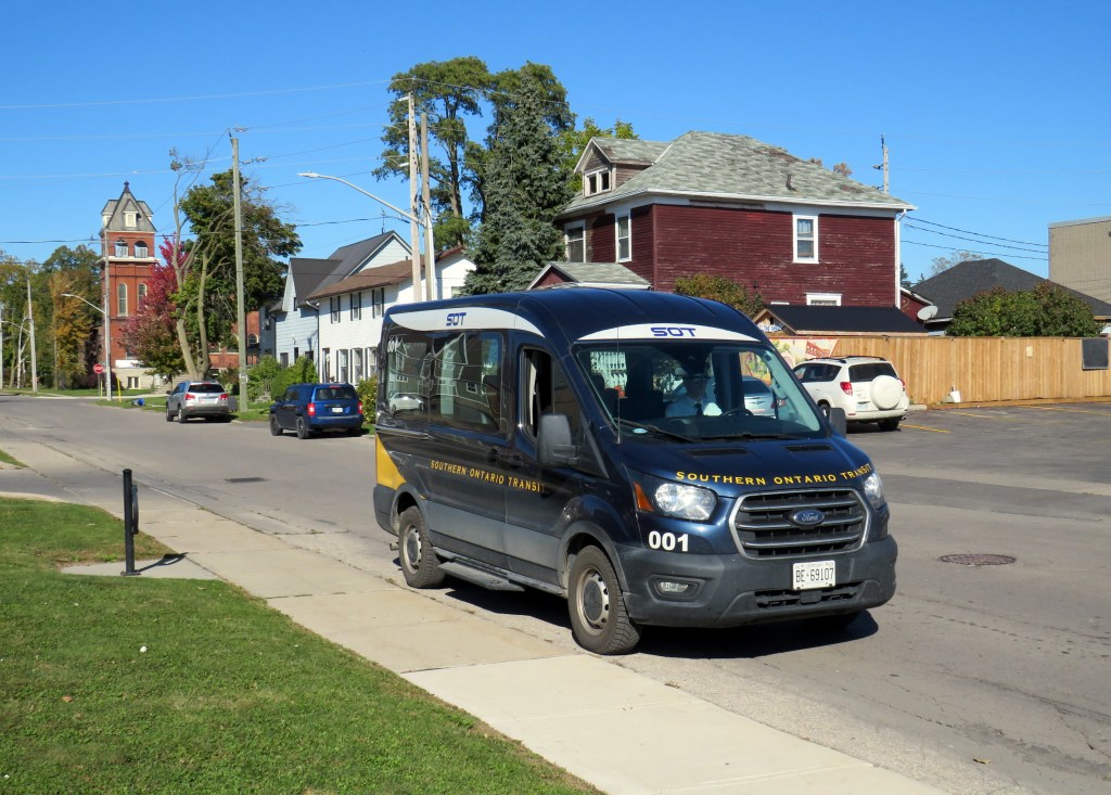
Southern Ontario Transit minibus in Dunnville, October 2024
Earlier in October, I got to meet Rae Rivard, owner-operator of Southern Ontario Transit (SOT), a new intercity transit operator currently serving Hamilton and Haldimand County. The route, which launched on September 16th, offers three weekday round trips between Downtown Hamilton and Dunnville, serving the communities of Caledonia, Hagersville, and Cayuga.
Haldimand County, along with the neighbouring Six Nations and Mississaugas of the Credit First Nation reserves, remained unserved by intercity or local bus services since the early 2000s; in 1990, United Trails operated a daily bus between Port Dover, Hagersville, Caledonia, and Hamilton. Cayuga and Dunnville were served by a Greyhound route on Highway 3 between Niagara and London. More recently, as Niagara Region was building a regional transit service and Norfolk County successfully applied for provincial funding for a new service between Simcoe and Brantford, Haldimand County refused to take part. Enter SOT.
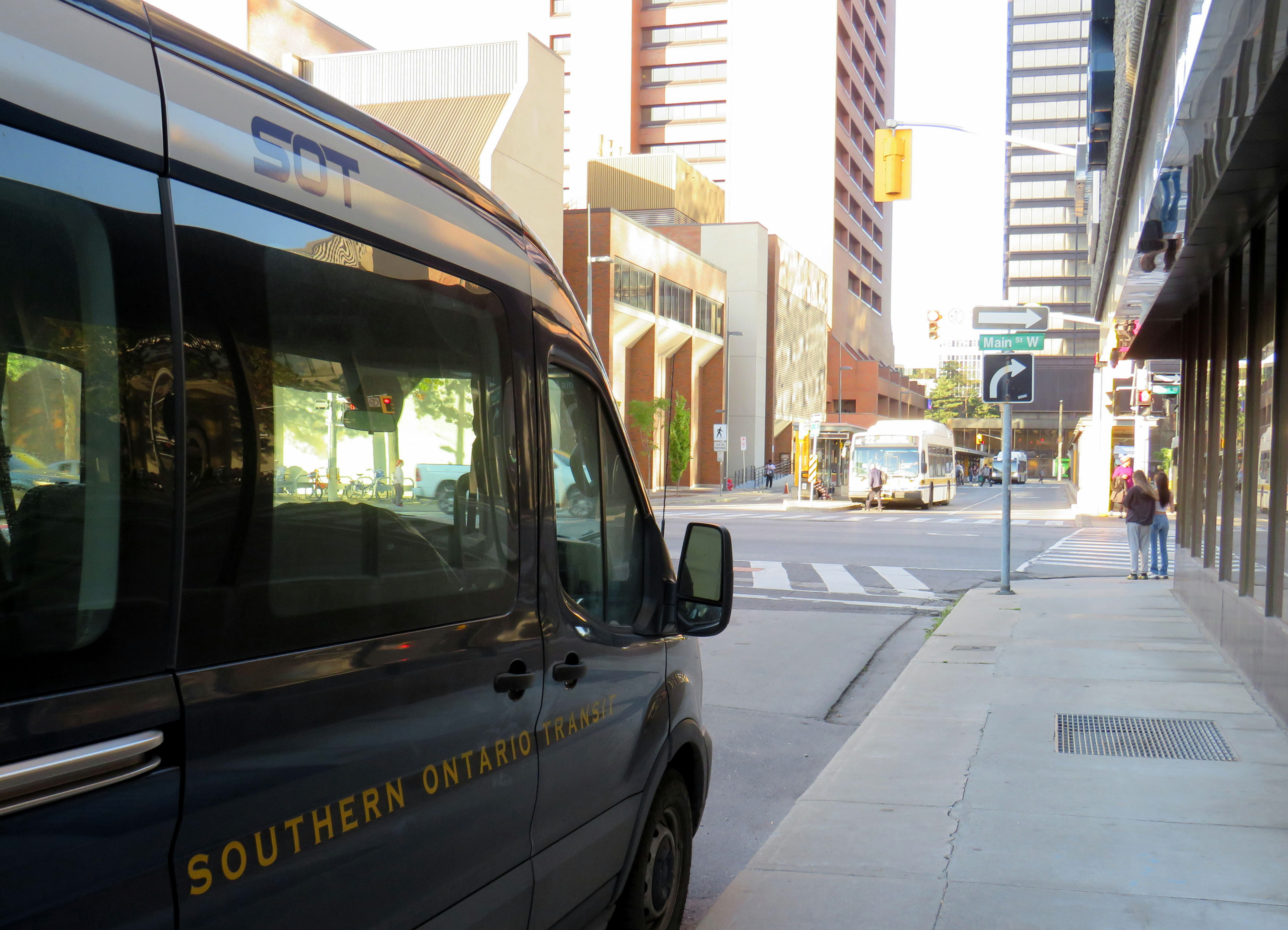
SOT, which charges a $10 one-way fare, operates without the support of the municipal government, and is unable to put up bus stop signs or actively promote its service at municipal facilities such as libraries or community centres. For this reason, ridership remains low, despite growing populations in Caledonia and Hagersville and convenient links to Hamilton Airport, Mohawk College, St. Joseph’s Hospital, and to GO Transit and HSR services.
Rivard will tell you that “the primary challenge we face today is slow uptake. Due to a number of limitations and challenges currently out of our control, the number of regular and new riders trends up every week, but not as fast as we need to cover expenses…. Many of the limitations we are dealing with right now can easily be addressed at no expense, but these choices are out of our control.”
Rivard reached out to businesses and social service organizations, but was turned away, adding that “the entire operation has been entirely funded out of me and my wife’s savings, and we are really struggling to keep up with expenses at this rate.”
Without approved bus stop locations with curb access, SOT is not able to provide fully-accessible service, though it already has a wheelchair-accessible vehicle. The lack of physical bus stops and publicity has made it difficult to attract riders, though while riding with Rivard on a beautiful October afternoon, it was clear that a demand exists as several residents came up to the minibus to find out more information.
My hope is that word spreads about this unique and essential operation and that the local communities provide the needed support to make this service work. If this initial route succeeds, SOT would like to expand service in Haldimand and take on other gaps in the Ontario network.
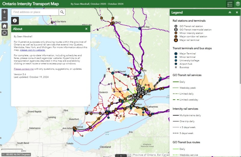
I updated my Ontario Intercity Transport Map to add Southern Ontario Transit’s route. Commuter Connect in Northumberland County ended service not long after VIA Rail finally resumed its early morning train from Kingston to Toronto. East Zorra-Tavistock Transit in Oxford County did not last long either, and service there has ended.
Added to the map:
Southern Ontario Transit between Hamilton, Caledonia, and Dunnville
Red Arrow’s daily Toronto-Western University express, which replaces its Toronto-Niagara Falls run
A new daily Flixbus route between Toronto, Hamilton, and St. Thomas
A new OnexBus route between London, Goderich, and Port Elgin, operating Friday through Monday
OnexBus’s London-Pearson Airport-Brampton route, which operates several trips a day
Ourbus’s Toronto-Ottawa route
Kasper’s daily Winnipeg-Kenora-Sioux Lookout service
Revisions to on-demand services in Niagara Region
Some revised routings and service levels across the province
Removed from the map:
Commuter Connect in Northumberland County
East Zorra-Tavistock Transit
Kasper’s on-demand service to Red Lake/Balmerton
Though it is good to see Bruce County — particularly rapidly growing Saugeen Shores — get another link, that part of Ontario is still poorly served; there should be daily services between larger Bruce County communities like Saugeen Shores, Kincardine, and Walkerton at least to Owen Sound and Hanover. Lindsay is also left without any intercity services, after TOK ended service from Toronto to Haliburton last year. where a Peterborough-Lindsay-Pontypool service, perhaps extending to Durham College/Ontario Tech University in Oshawa could prove to be a very useful route.
If you like this post and you would like to help out with my online mapping and webhosting costs, consider buying me a coffee.Thank you!
The old Doug Ford — the angry bull-in-a-china-shop we remember from 2018-2019 — is back, and it is clear that governing, in fact, has not changed him. After six years, and a rumoured early provincial election, Doug Ford will need to run on something, because there’s little to show for his promises of getting housing built, transit projects completed, and hospitals fixed. An RCMP investigation continues to look at the government’s Greenbelt land swaps, and it is rare for provincial or federal governments in Canada to get elected with a majority three times in a row. So here we are.
But after three straight days of political red meat policy announcements, the strategy has become clear: Doug Ford is “deadcatting.” Dead cat theory, popularized during the leadership of former London mayor and British prime minister Boris Johnson, is the practice of suddenly throwing down an outrageous policy or statement to divert attention away from an unpleasant topic. The shocked audience is suddenly compelled to talk about the metaphorical dead cat thrown on the table. In the United States in recent weeks, dead cats have become less metaphorical, with baseless and racist accusations against Haitian migrants in Ohio spread by Donald Trump, vice-presidential candidate J.D. Vance, and far-right commentators.
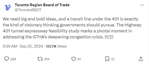
There is no way a Highway 401 tunnel will be built. Not only would it be the longest road tunnel in the world, but the long on-ramps and off-ramps required to access a deep-bore urban highway tunnel will make it completely infeasible. The proposal also completely ignores the problem of induced demand, and it won’t solve the problem of where the traffic goes when it gets off that additional highway. For these reasons, it was especially disappointing to see the Toronto and Region Board of Trade (TRBoT) endorse the idea.
There are things that can help alleviate traffic. One is ensuring that transit projects are completed, funded, and maintained. That doesn’t just mean building and completing projects like the Crosstown LRT and the Ontario Line, it’s also making sure the system remains in excellent condition to avoid problems like the persistent slow orders in the Toronto Subway. It also means making the best use of existing infrastructure, like Highway 407, for goods movement. Highway 407 passes by every major freight yard in Greater Toronto, but trucks clog Highway 401, Highway 7, and Steeles Avenue instead because of the high tolls. And it means active transportation improvements, like bike lanes and multi-use paths.
What we don’t need are more dead cats to distract us from the real problems.
No matter how you get around Toronto, it’s feels like it’s more difficult than ever
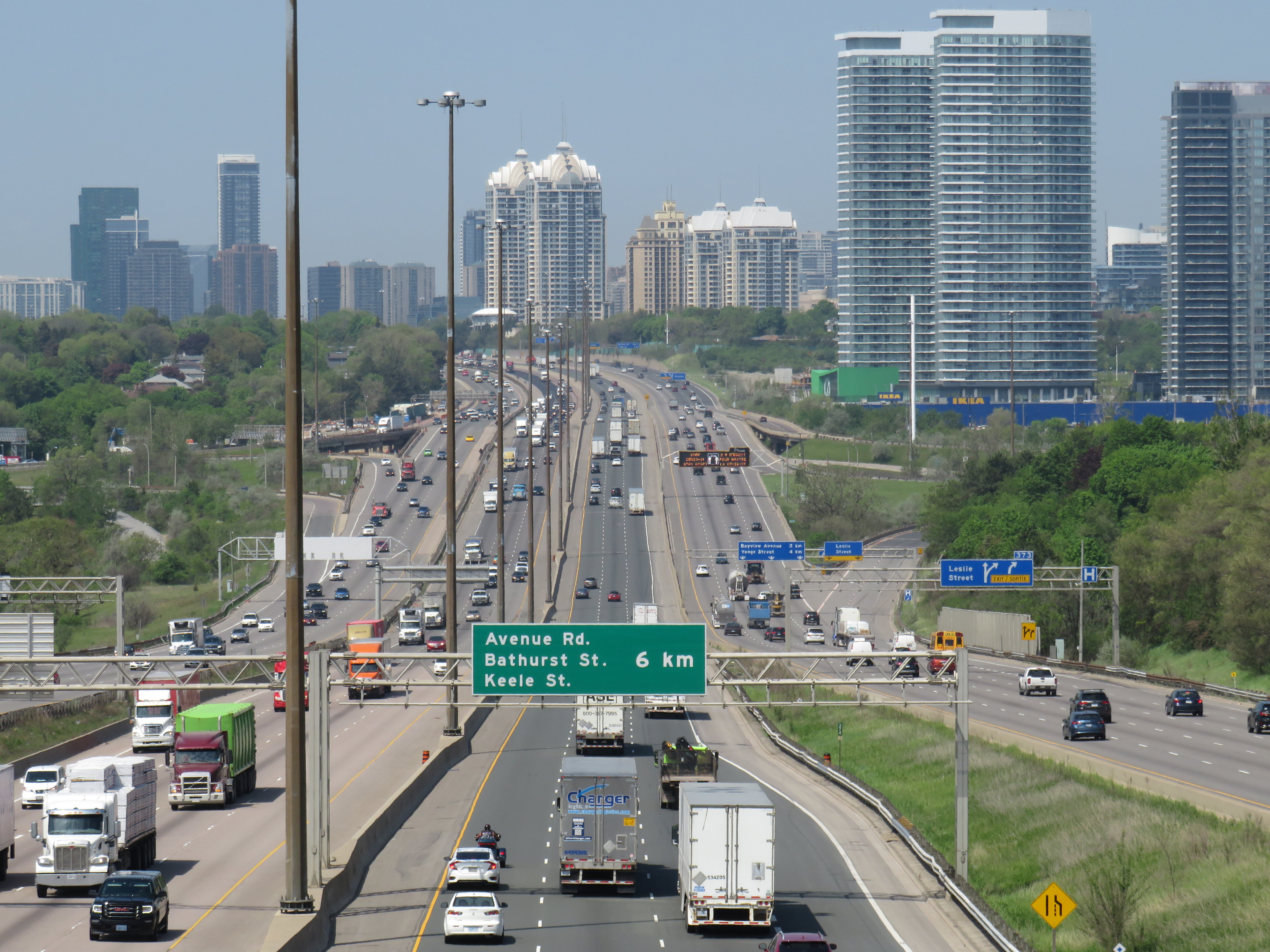
Getting around Downtown Toronto can be an exercise in frustration, whether you drive, bike, take transit, or drive. Though necessary transit and road construction projects are the cause of much of the congestion, driver behaviour, poor management, and a lack of coordination between various municipal and provincial agencies have only added to the traffic quagmire.
North-south streets such as Spadina, York, Bay, and Jarvis are jammed by drivers headed south towards the Gardiner Expressway, with lane closures near Exhibition Place only making things worse. Motorists blocking intersections make it difficult for pedestrians, cyclists, streetcars, and through traffic to get across the city centre. Ontario Line construction has closed a portion of Queen Street, while work to rebuild streetcar tracks on York and Adelaide Streets to allow 501 cars to bypass the closure is still proceeding.
GO Transit is also expanding its rail corridors to allow for more off-peak and express trains, with the long-term goal of having an electrified, frequent, regional rail network that complements and supplements the web of subways, light rail and buses throughout the region. The TTC is also addressing a backlog of state-of-good repair works throughout the subway system, resulting in slow orders, early closures, and weekend shutdowns.
Meanwhile, people still need to get to places like work, school, conferences and trade shows, concerts, sporting events, social gatherings, festivals, museums, and all the other things that make a city a city. Eventually, with improved GO corridors, the Ontario Line, and the opening of the Crosstown LRT, there will be some redundancy in the transit system that will make planned service closures easier to navigate. But for now, we are stuck with an underbuilt transportation system in a rapidly growing city.
This makes the coordination of transit closures and projects especially essential so things don’t completely fall apart. Saturday, September 21 was just one example of the failure to do so.
On Saturday September 21 and Sunday September 22, GO Transit reduced service on the Lakeshore West Line to hourly service on the entire corridor because of work at Long Branch GO Station, where the station is being completely rebuilt for accessibility improvements and future expansion. It also shut down the entire Barrie Line for various construction works along the corridor, with rail replacement buses to Union Station, stuck in traffic on the Don Valley Parkway and Lake Shore Boulevard with all other motorists getting around the Gardiner closure.
Normally, there are hourly trains as far west as West Harbour Station in Downtown Hamilton, with half-hourly service to Aldershot Station in Burlington. Between Union and Oakville, rail service is as frequent as every 15 minutes during midday and early evenings on Saturday and Sunday. Hourly train service reduced capacity on the inner Lakeshore West line by 75%.
Compounding the problem was the total closure of the Gardiner Expressway between Highway 427 and the Don River between Friday evening and Sunday morning for routine maintenance (the Gardiner and the Don Valley Parkway are regularly closed twice a year for repairs). Many people who might have otherwise driven into the city would have taken GO Transit instead, normally a very good idea. Though none of Toronto’s professional sports teams were playing at home on Saturday, there was still a Shane Gillis stand-up comedy performance at Scotiabank Arena, and a Rainbow Kitten Surprise concert at Ontario Place.
Also, to add insult, the Lakeshore East trains between Toronto and Oshawa were not through-running with the Lakeshore West trains and were operating on a modified schedule. I was travelling east of Toronto on Saturday, making a few stops in Durham Region. As I arrived back from Whitby on Saturday afternoon on a train that normally connects onward westbound train at Union Station, we were treated to the sight of the hourly Lakeshore West train just pulling out. It couldn’t have even waited 2-3 minutes to allow passengers to make the cross-platform connection. That resulted in other passengers complaining to GO staff in the concourse, who were not that helpful.
I’m on the GO Train now. The CSR on the LW train is telling people at Long Branch to not board because the train is too full, so they now have to wait an hour. Lots of people heading to Budweiser Stage and Scotiabank concerts. Very poor planning/coordination between city and MLX. https://t.co/LXNATzYwoV
Tweet from Alan Deschamps, reporting on a full GO train arriving at Long Branch at 6:21 PM on Saturday Sept 21, with the customer service ambassador (CSR) telling waiting passengers to not board and to wait for the next train in an hour
In the early evening on Saturday, a jam-packed eastbound GO train on the Lakeshore East train was not accepting any passengers at Long Branch or Mimico station because of overcrowding. Waiting passengers were told to wait an hour for the next train.
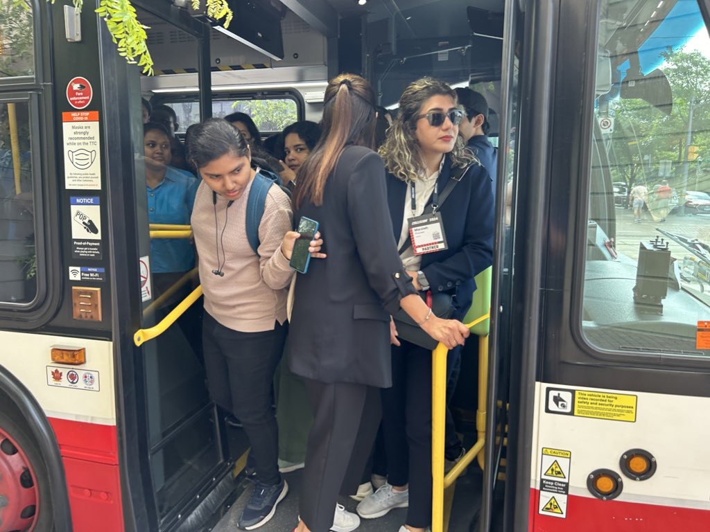
One would think that Metrolinx (GO Transit’s parent agency) and the City of Toronto would coordinate their construction schedules to avoid such problems. However, not even the City of Toronto can figure this out. Back in June of this year, the TTC replaced the 509 Harbourfront and 511 Bathurst streetcars with buses for a week for minor overhead work on Fleet Street. The timing coincided with the massive Collision tech conference at Exhibition Place, which resulted in overcrowded shuttle buses and unreliable service. Had the TTC checked with anyone at the city’s economic development office or with Exhibition Place (another city agency), this work could have easily been rescheduled.
Overloaded 509 Harbourfront bus shuttle on Queen’s Quay in June 2024
Though coordination of transit closures and construction projects with major events and parallel roadworks will not solve Toronto’s road and transit congestion problems, it will at least reduce some of the frustration of getting around. The poor customer service at GO Transit will certainly make riders question if they will be able to rely on the service in the future.
Of course, there is one measure that won’t help but still will be implemented by the provincial government later this fall: a prohibition on new bicycle lanes if they take road space from motorists. Despite blocked bike lanes, aggressive drivers, and an incomplete cycling network, it is still the most reliable and fastest mode for many shorter city trips. Along with major transit improvements and construction coordination, cycling is one of the solutions to getting around Toronto.
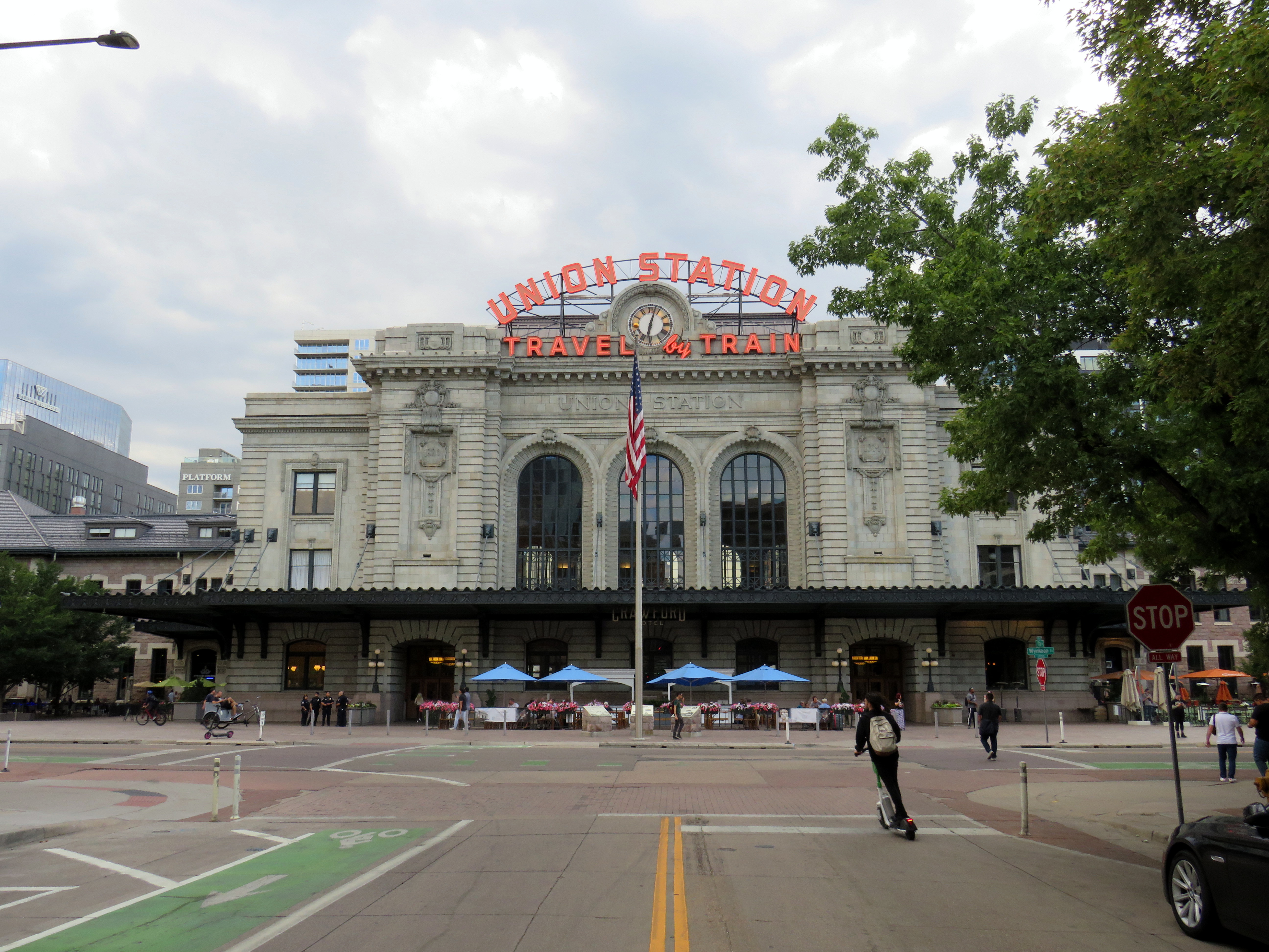
Denver’s Union Station, with the iconic “Travel by Train” neon signage
Earlier this summer, I had the privilege of travelling with my spouse to California. We started in San Diego (where my partner was attending a conference) and then made our way northwards, to Los Angeles, Santa Barbara, San Simeon, and finally the San Francisco Bay Area. I continued my trip an extra three days to ride Amtrak’s California Zephyr train east through Nevada and Utah to Denver, Colorado.
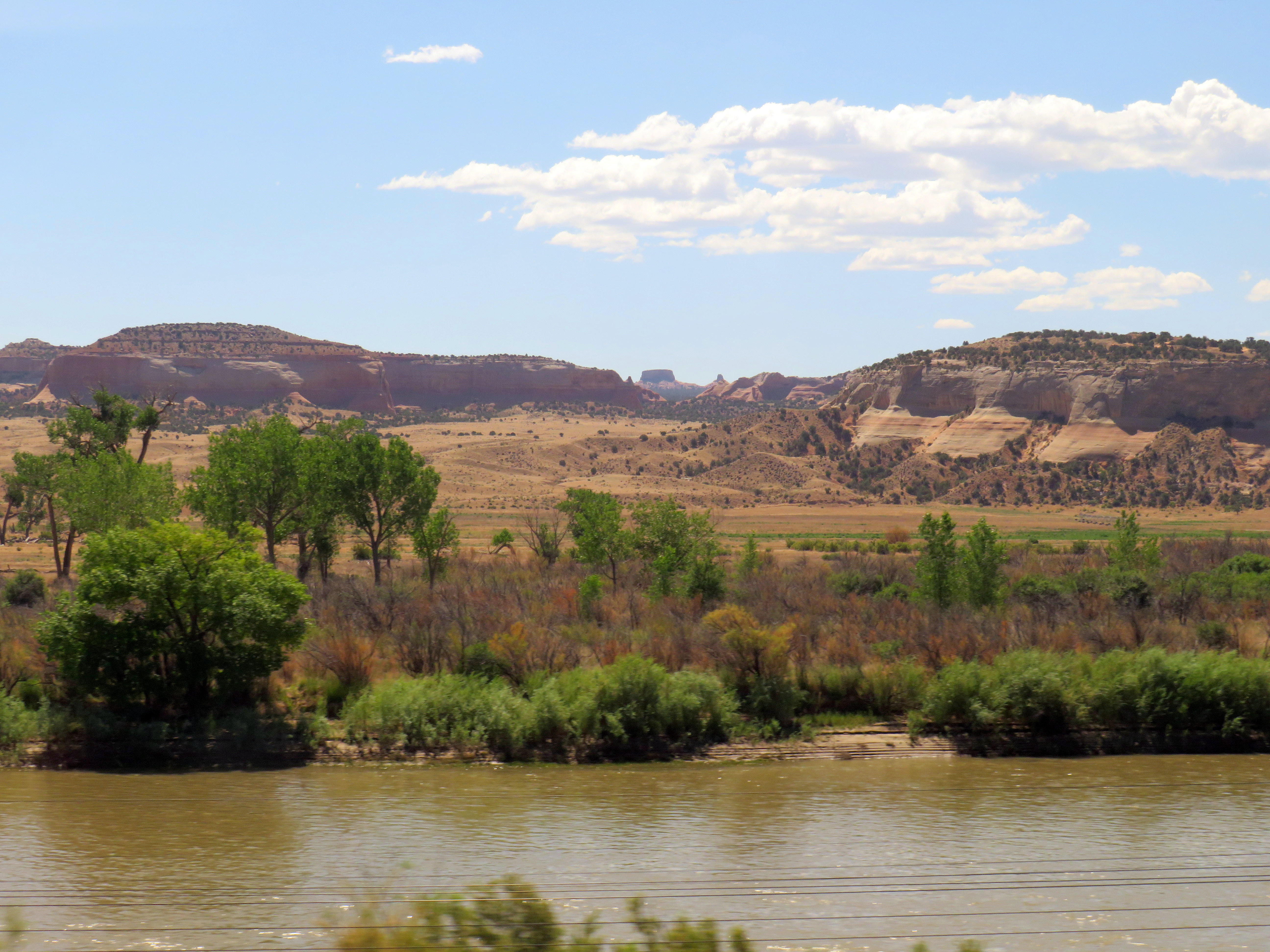
Looking south from the California Zephyr across the Colorado River near the Utah-Colorado border
Besides the breathtaking scenery through eastern Utah and western Colorado, I wanted to visit Denver itself, including its Union Station.
Denver’s Union Station was constructed in 1881 to serve the Denver Pacific Railway (the city’s connection to the Union Pacific transcontinental railroad at Cheyenne, Wyoming), as well as the Denver & Rio Grande, the Denver, South Park & Pacific and the Colorado Central Railroads. (Today, it is reached by tracks belonging to the Union Pacific or BNSF Railroads.) Renovated and expanded in 1914, one of the station’s most iconic features, rooftop neon signs beckoning customers to “Travel by train” were added in the 1950s, as interstate highways were being planned and constructed across the United States and air travel became more common.
The station was nearly closed in the 1980s with only Amtrak’s Oakland-Chicago California Zephyr calling once a day in each direction. Passenger train facilities would have been moved to a small “Amshack” building outside of the downtown core, with the station building incorporated into a proposed new convention centre. (This proposal is similar to the fate of St. Louis’ Union Station, which was turned into a hotel, shopping, and entertainment centre, with the Amtrak station moved into a small building off-site.) Luckily, this never took place.
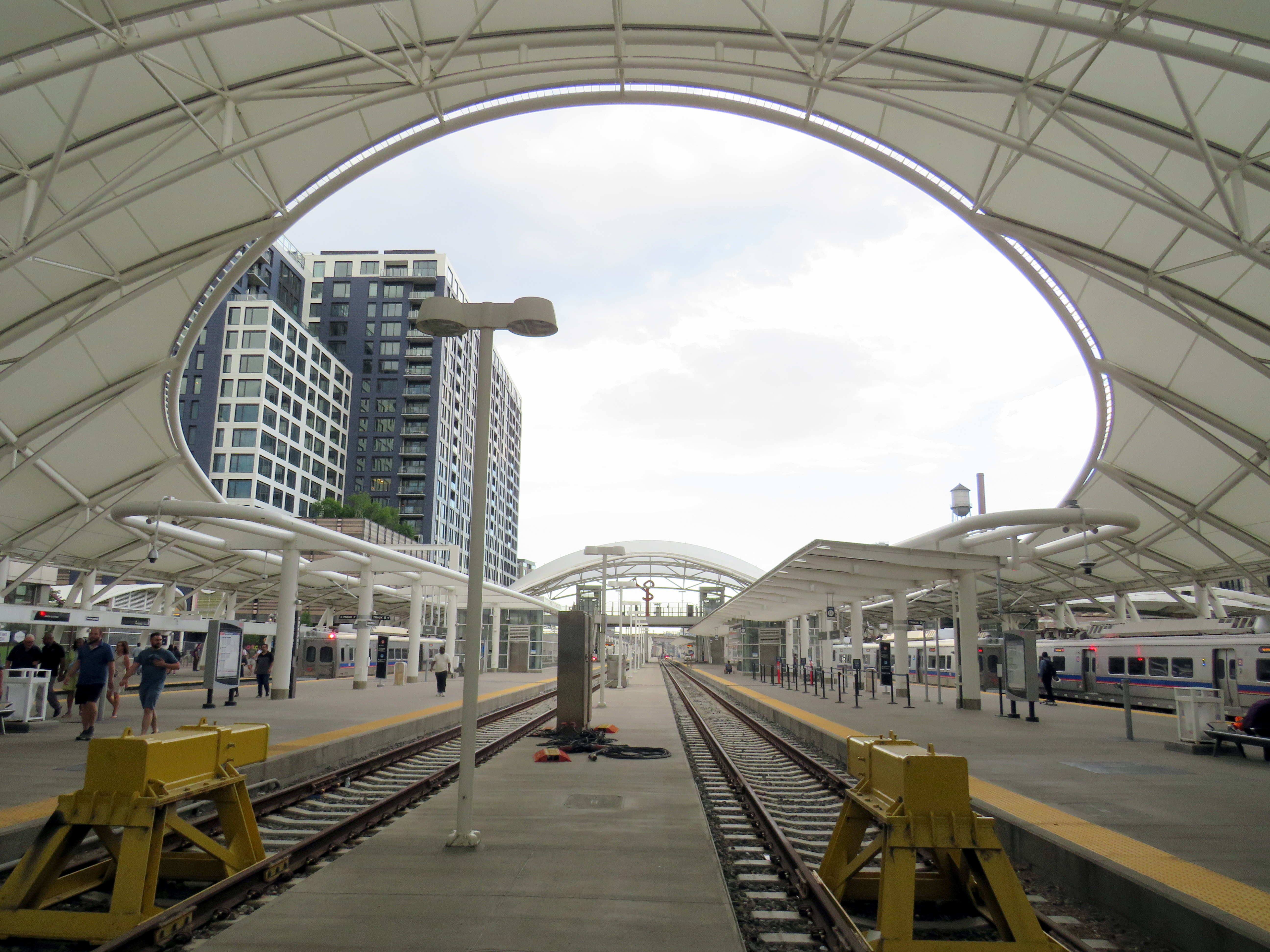
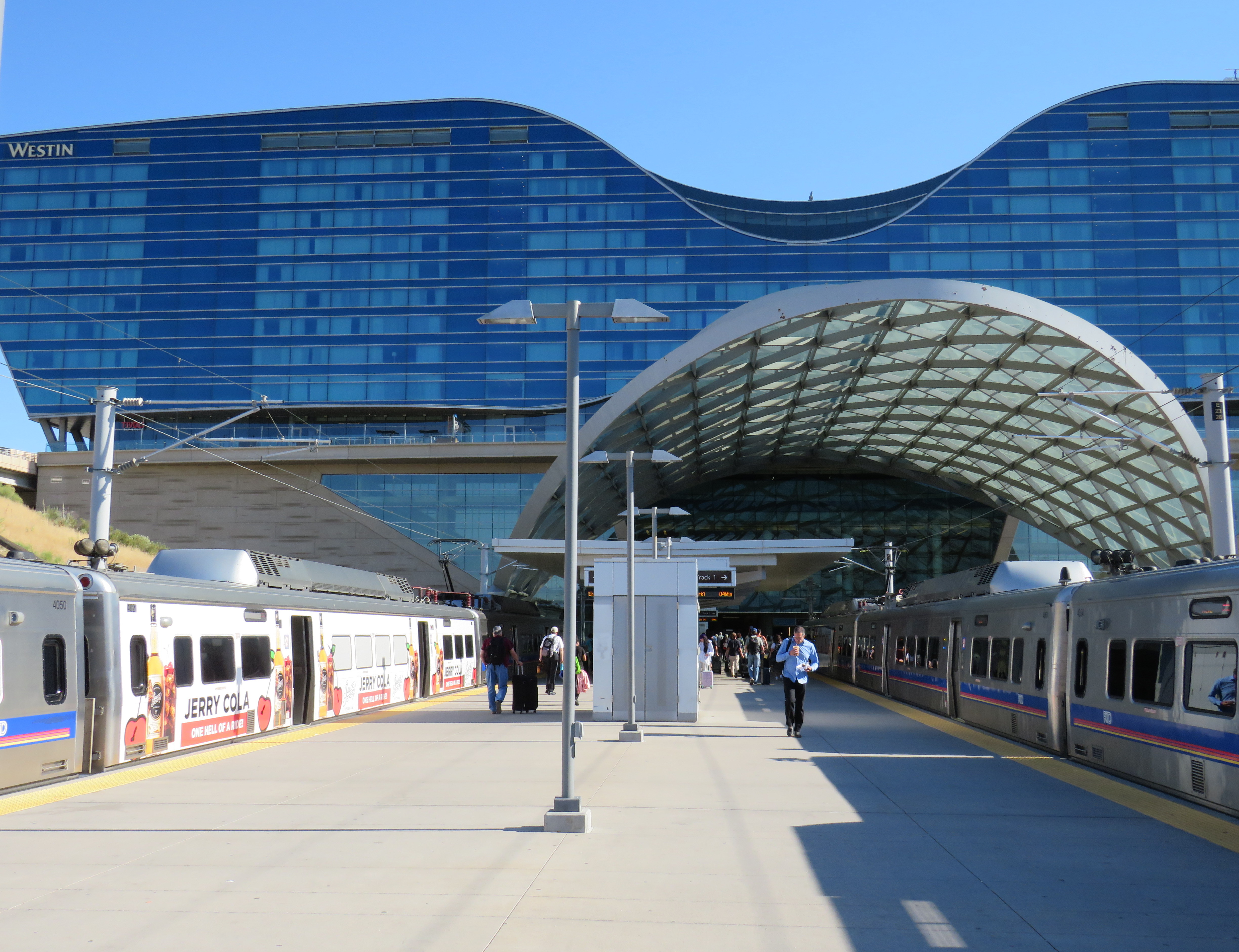
Denver’s Regional Transit District (RTD) purchased the station in 2001, with a new master plan developed for the station property and the vicinity in 2002, approved by voters in 2004 as part of the “FasTracks” program. Denver’s light rail system was extended to Union Station in 2002, while the immediate area was redeveloped with midrise apartment and office buildings. The train platforms were rebuilt with a new canopy, meant to accommodate both Amtrak and proposed new commuter and regional rail services.
Denver Union Station train platforms
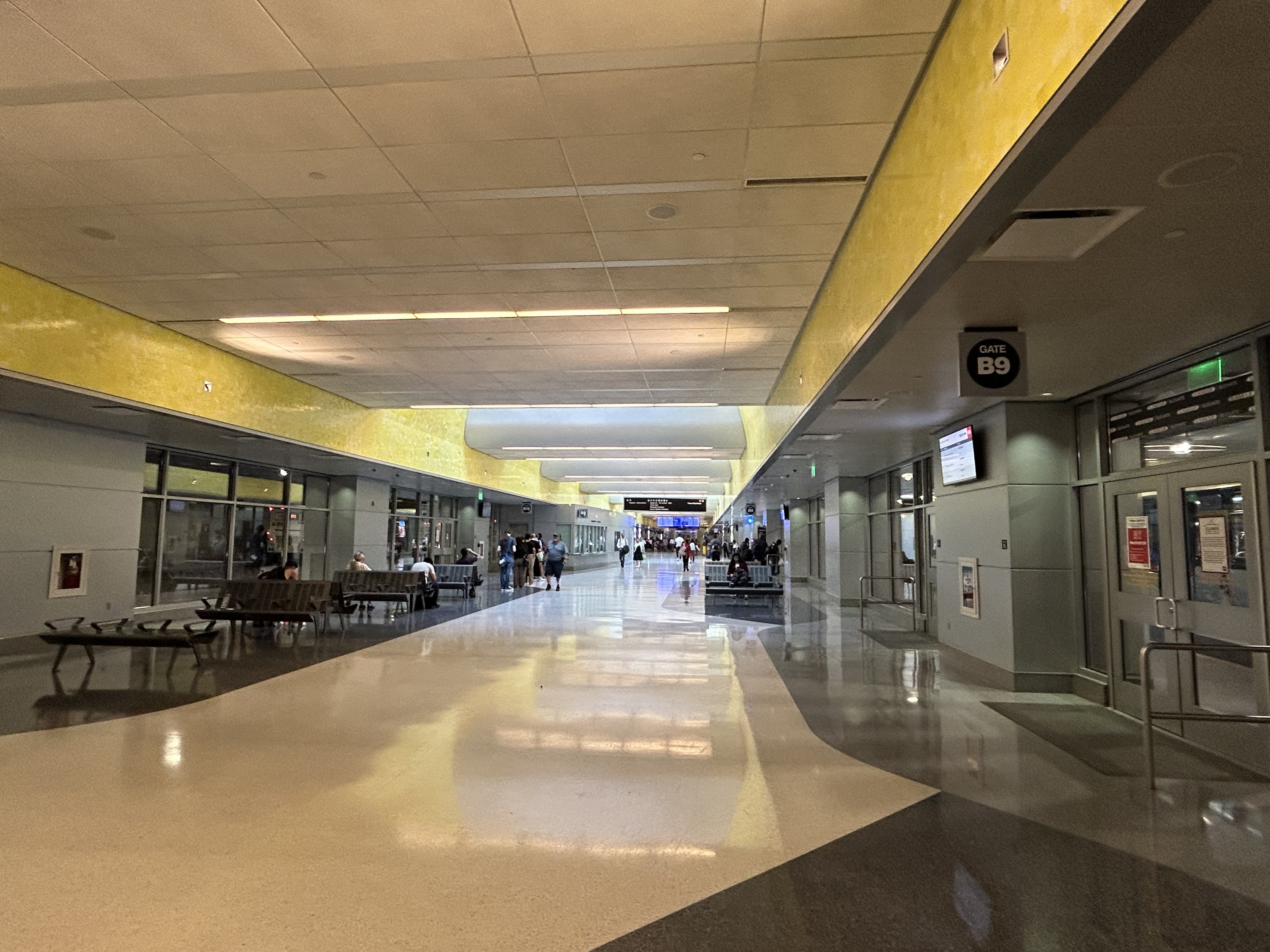
Connecting the historic Union Station building and train platforms with the LRT platforms two blocks north is a long underground bus concourse.
Denver Union Station’s underground bus terminal
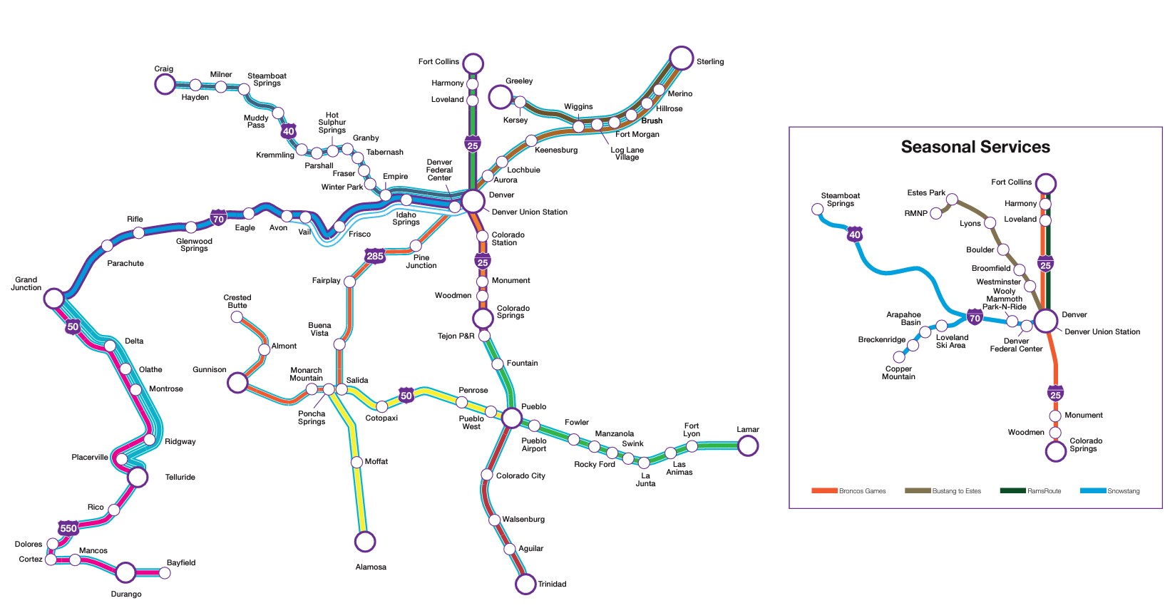
The underground bus terminal serves local and regional RTD services, as well as Bustang, the State of Colorado’s intercity coach service. Bustang offers multiple daily bus services to cities such as Colorado Springs, Fort Collins, Grand Junction, and Pueblo, connecting most of the state together. There are also seasonal ski buses from Denver, along with special runs for Denver Bronco games.
Bustang service map
There are also two free RTD bus services connecting Union Station with the rest of Denver’s downtown core: MallRide, a frequent, daily service along the 16th Avenue pedestrian mall (which was undergoing reconstruction in July 2024, and was on detour), and MetroRide, which operates during daytime hours on a parallel route.
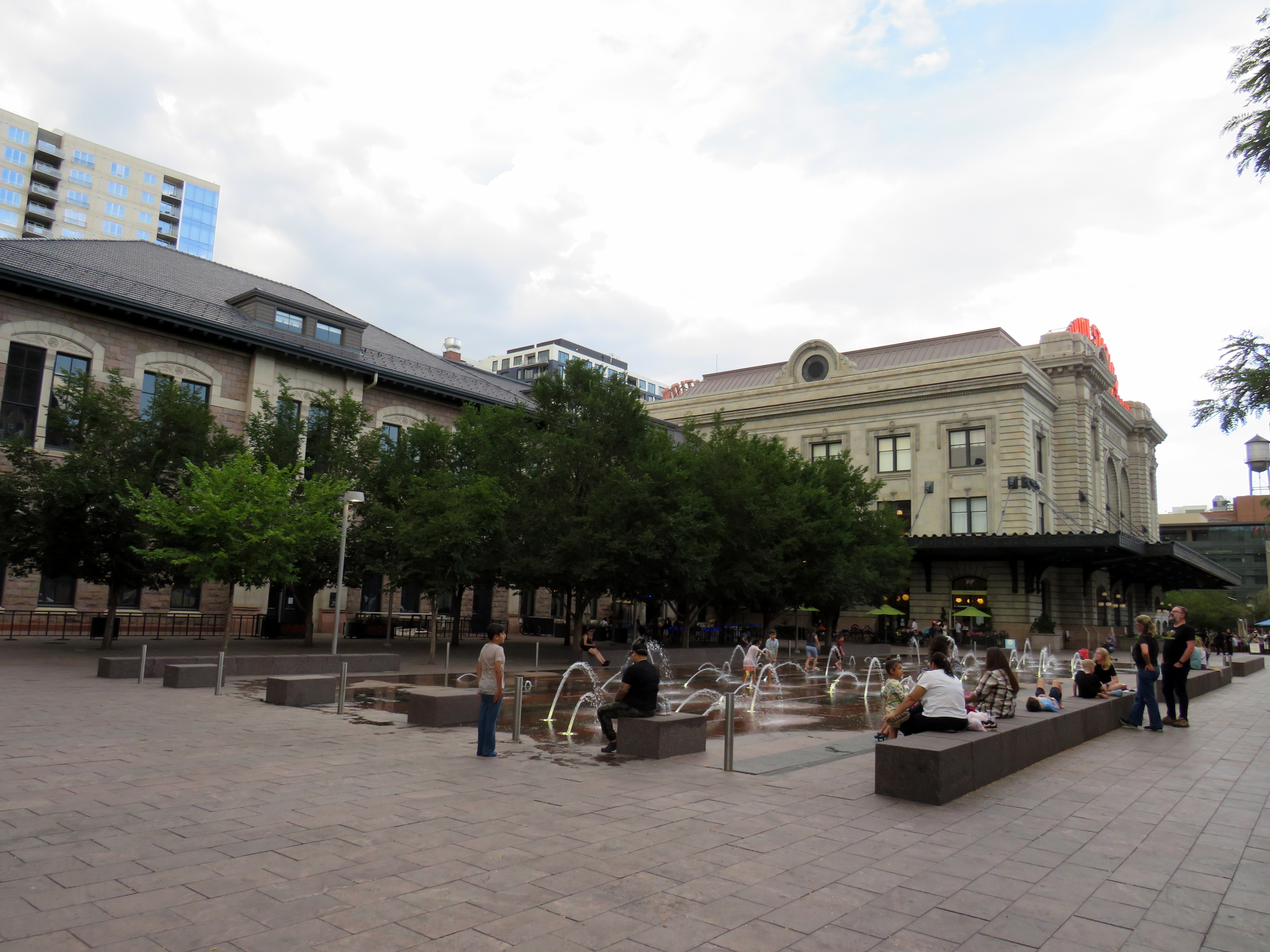
Splash fountains in the Union Station west plaza
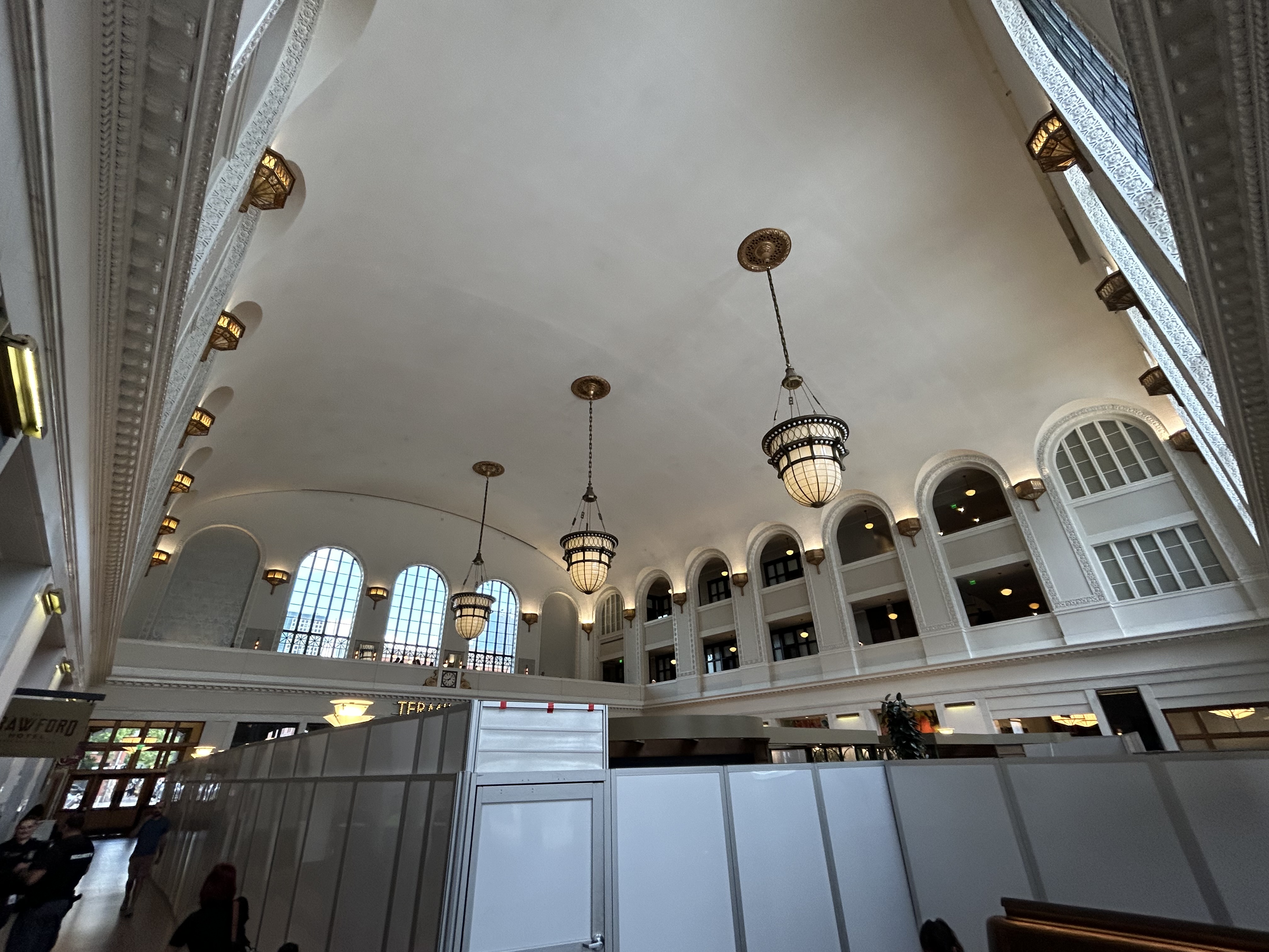
Union Station now hosts a boutique hotel, several restaurants and bars, a branch of a local bookshop chain, and includes amenities such as public art and a splash fountain outside its main entrance. Though the main lobby was undergoing minor renovations, it was clear how much work went into the project.
Union Station lobby
Take the A-Train
Arriving at Denver International Airport
Like Toronto’s Union Station, Denver offers an airport rail link, operating every 15 minutes most of the day. The electric A-Line train runs from Union Station, making 7 intermediate stops. With the exception of the airport itself, the A-Line operates within the regular RTD fare zone, with free transfers between connecting buses and trains.
To enter or exit the airport station itself, occasional travelers must purchase a special $10 day pass (a standard day pass is $5.50), but that, of course, includes all rides taken before or after arriving at or departing from the airport. (By contrast, there are no transfers or fare discounts when connecting between UP Express and GO Transit, TTC, or suburban transit services.)
Because of the additional stops and the long distance between Downtown Denver and the international airport (25 miles or 40 kilometres), the trip takes 37 minutes versus UP Express’ 25 minutes.
Unfortunately, most RTD rail services, like the A-Line, follow existing or abandoned rail corridors. Though these routes offer limited obstructions to construction and allow for faster service than operating within roadways, they limit how much ridership can be generated by walk-on service. Even the Downtown Littleton station on the D-Line is distant from any commercial or residential uses, with a large commuter parking lot behind the historic station building.
At least many RTD stations offer convenient bus transfers, which draw much of the ridership.
The D-Line LRT at Littleton, Colorado
A lot was done right at Denver Union Station, which is well served by local, state, and national rail and bus connections, and is serves well as a model for developing a good intermodal hub in a midsized city like Denver. There are certainly aspects that could be replicated at some GO Transit stations, such as Brampton, Port Credit, or Unionville, which are poised to become important intermodal hubs, such as great public spaces, easy connections between nodes, and complementary retail spaces. At Brampton in particular, much can be done with the small historic station building there to make it a centrepiece of a great downtown redevelopment.
I am glad I visited Denver, and I am glad to have travelled by train.
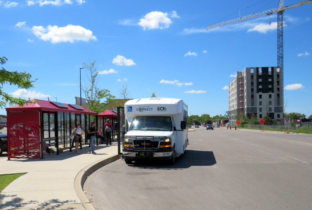
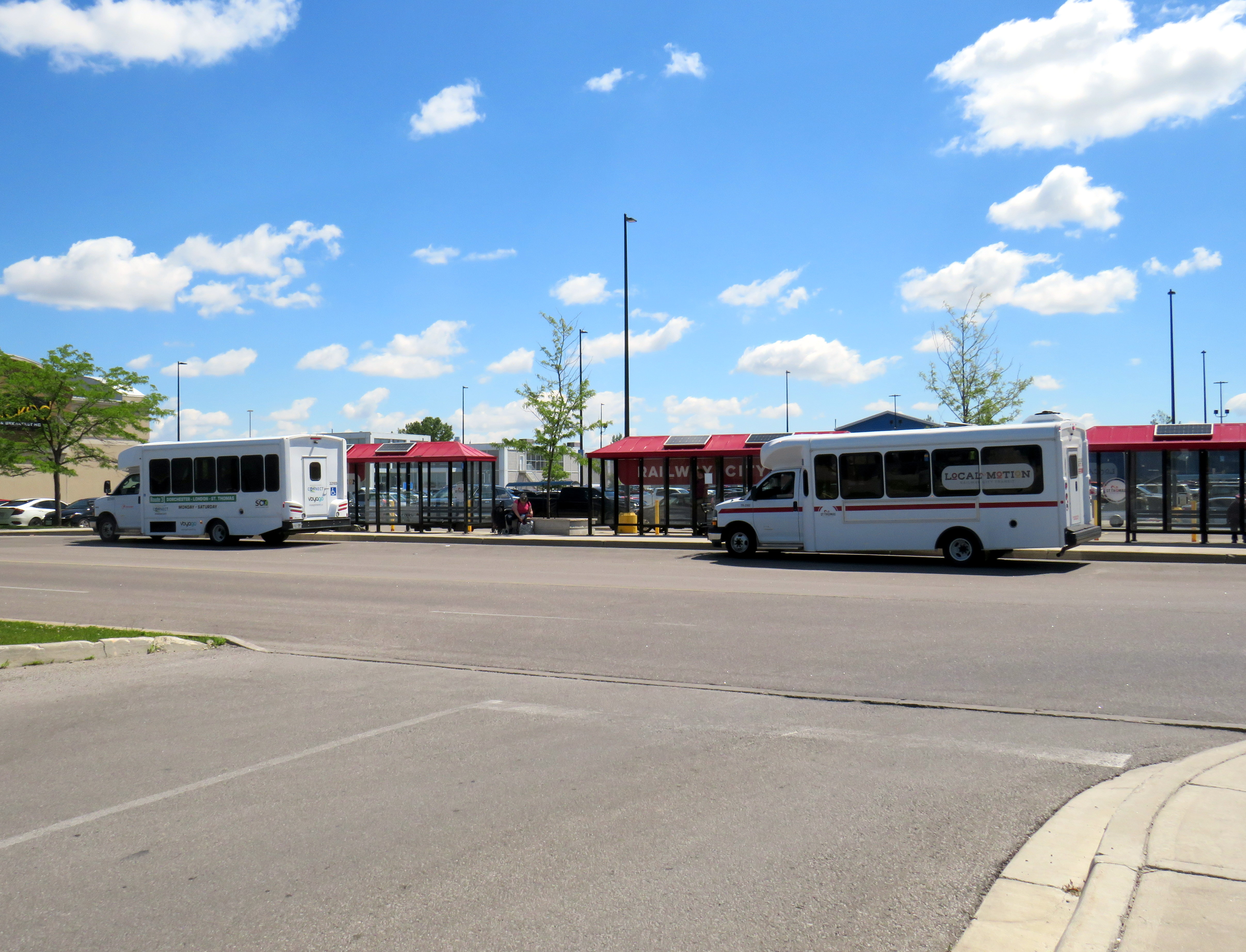
Middlesex County Connect and “Local Motion” buses at St. Thomas, June 2024
On Saturday, June 15, I took a trip that was not possible for over a decade: I went to St. Thomas, Ontario, without a car. This was possible because of one of several new intercity transit links that opened this year in Ontario, and I have updated my interactive map accordingly.
The Pennsylvania Trolley Museum now features a new main entrance and exhibition hall, along with an on-street boarding area complete with vintage signage.
While visiting Pittsburgh earlier in June, I also paid a second visit to the Pennsylvania Trolley Museum (PTM), located 45 minutes south of Downtown Pittsburgh in Washington PA. I had visited the museum a few years prior as part of a visit to the Pittsburgh area, but since then, a new section of the museum opened to the public, and there were additional cars in operation.
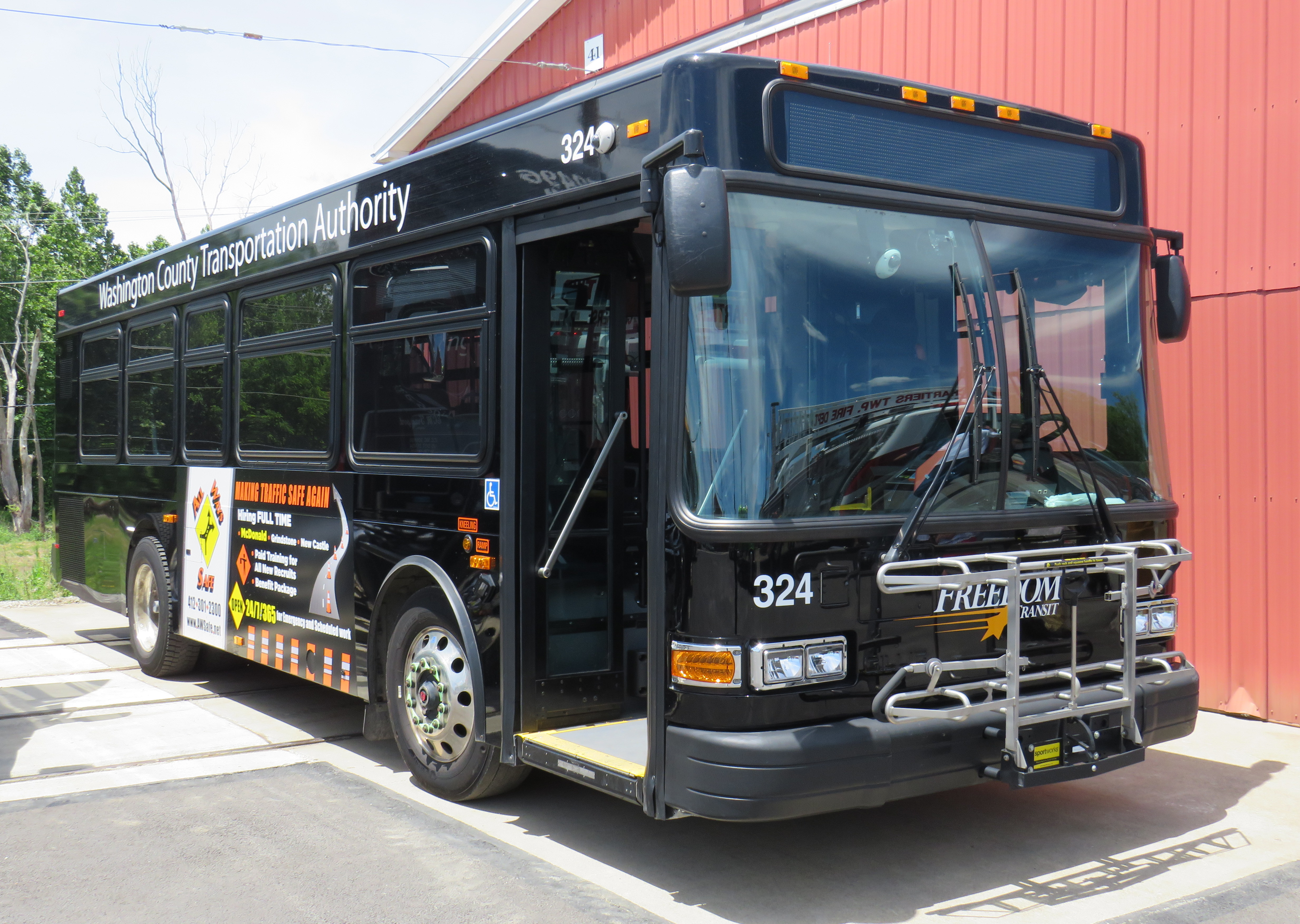
While I went to PTM with a friend who planned to stick around until the evening, I planned to return to downtown Pittsburgh earlier in the afternoon. I found information on a local transit service operated by Washington County — called Freedom Transit — that ran a route to and from Pittsburgh that stopped not too far from the museum’s main entrance. That plan did not go well at all.
It is an unfortunate irony that most North American transit museums have poor or non-existent transit access. There are historical reasons why this came to be, but some of the continent’s best transportation exhibitions are inaccessible to newer generations of transit fans, historians, and enthusiasts, many of which do not or cannot drive.
Washington County Transportation Authority, or “Freedom Transit,” doesn’t offer much freedom(more…)