Tag: Cycling

  • The John Tory Way

    32267768383_8c2f20d0d5_k
    Yonge Street looking south from Richmond Hill

    There’s an episode of The Simpsons where Homer Simpson changes his name to Max Power, after he’s ridiculed for sharing the name with a buffoonish television character. It’s not a great episode — it came out at the time the show was in transition from its glory years to the “Zombie Simpsons” era — but it has a few good laughs.

    There’s one good memorable quote:

    — “There’s the right way, the wrong way, and the Max Power way!”
    — “Isn’t that the wrong way?”
    — “Yeah, but faster!”

    On important transportation projects, the John Tory way is the wrong way, but costlier. We’ve seen this several times during his mayoralty.

    When it came time to replace the underused eastern section of the Gardiner Expressway, Tory and his suburban allies on council voted in favour of a more expensive “hybrid” option that maintains much of the elevated highway, instead of a cheaper at-grade option that would provide a better pedestrian realm on the Eastern Waterfront and better support new development.

    In Scarborough, Tory stubbornly supports building a one-stop subway extension that was last estimated to cost $3.35 billion dollars, instead of supporting a seven stop LRT route from Kennedy Station that would extend the existing grade-separated Scarborough RT route to Centennial College and Sheppard Avenue. A proposed SmartTrack station at Lawrence East (whose estimated construction cost has risen from $26 million to $155 million) may not be able to be built while the Scarborough RT is still in operation.

    And on February 27, Toronto’s Public Works and Infrastructure Committee (PWIC) voted against plans backed by city staff, the local councillor, John Filion, and many residents and road safety advocates, to transform Yonge Street in North York Centre between Sheppard and Finch Avenues. This section of Yonge Street is due for reconstruction, hence the opportunity to rethink the street to better serve the community.

    The REimagining Yonge Street plan seeks to improve the pedestrian realm with widened sidewalks, would add new cycling infrastructure. To make room for these improvements, two traffic lanes — used for street parking outside of weekday rush hours — would be removed. This stretch of Yonge Street has seen many new condominium towers built over the last decade, and there are three subway stations serving this stretch of Yonge Street.

    Mayor Tory, who has the power to select committee chairs and members, stated his preference for the status quo on Yonge Street, suggesting that the bike lanes be moved one block west, to Beecroft Avenue. PWIC moved for this alternative option as well, even though city staff reported that the change would cost an additional $20 million.

    YongeCrossSectionYonge Street between Sheppard and Finch Avenues would have seen new separated bike lanes, wider sidewalks, and new public art. (From the EA materials.)

    The decision to maintain the status quo on Yonge Street benefits commuters outside of Toronto more than local residents, so it is puzzling why Mayor Tory has declared his support — once again — for an option that puts drivers first. Nearly three-quarters of rush-hour drivers on Yonge Street through North York come from York Region. A majority of residents take transit, walk, or cycle; they would benefit from a safer, more pleasant street. Moving the bicycle route to Beecroft Avenue serves to move cyclists out of the way of cars, rather than providing a direct route with better access to transit, shops, and homes.

    With Doug Ford focused on the Ontario Progressive Conservative party leadership race, there are — as of yet — no high-profile challengers to Mayor Tory’s re-election bid. There is no need to pander to a voting bloc angered by a so-called “war on the car” unless Tory actually supports suburban commuters over his own constituents. And this decision will only cost more money.

    Once again, Mayor John Tory has chosen the wrong way.

  • The trouble with those “cyclists dismount” signs

    IMG_3940

    Recently, I wrote about inconsistent, misleading, and problematic signage at road construction sites. Too often, cyclists are instructed to dismount and walk when a bike lane or general traffic lane is closed for construction.

    But these signs also exist where many multi-use trails and paths cross intersections. In suburban municipalities such as Brampton and Mississauga, multi-use paths adjacent to major roadways are preferred over on-street bike lanes (protected or not). But they too, are littered with signs instructing cyclists to stop, get off their bikes, and walk across the intersection, such as the example illustrated below, in Mississauga.

    IMG_2302-001

    The trouble is, the Ontario Traffic Manual (OTM), used by transportation planners and engineers to design roadways and install the appropriate signage, takes a dim view of signage requiring cyclists to dismount when on roadways or on multi-use trails:

    “It is sometimes necessary for cyclists to dismount their bicycle and walk when the terrain or cycling conditions are difficult and no alternatives exist. However, the option of asking cyclists to dismount and walk their bikes should not be relied upon in lieu of adequately accommodating cyclists through appropriate road design.”

    Book 18 of the OTM (available here as a PDF) states that the “dismount and walk” sign should “be used only in exceptional cases, such as where an in-boulevard facility ends, and cyclists would discharge into a sidewalk or pedestrian zone.” This clearly means that these signs should not exist when a bike route or multi-use trail crosses a driveway or an intersection, but only when the route ends and becomes a sidewalk, or at a pedestrian mall where cycling is not permitted. (Page 118, OTM Book 18, 2013 edition.)

    OTM Book 18 page 118Excerpt from page 118, book 18 of the Ontario Traffic Manual, December 2013 edition

    The OTM also says that “…cyclists usually find it difficult to rationalize why “dismount and walk” restrictions are in place, and conclude that they were a poor, illogical or arbitrary decision. Thus, if facility designs cause cyclists to make what they consider to be unnecessary stops, this will increase the likelihood that they will ignore or disobey traffic controls.”

    What the Ontario Traffic Manual does specify, is how signage, road markings, and design should be made to clearly mark crossing locations, warn motorists to watch for cyclists, and to remind cyclists to yield to pedestrians. Figure 4.103 from OTM Book 18, shown below, illustrates how a mixed pedestrian and cyclist route on the side of a road — like those in Brampton and Mississauga — should meet an intersection. While signs warn motorists and cyclists to watch out for each other, and for cyclists to yield to pedestrians, there are no “cyclists dismount” signs to be seen in the diagram.

    OTM Book 18 page 124 .jpg
    Illustration of how a multi-use trail should meet an intersection. Figure 4.103, from page 124, book 18 of the Ontario Traffic Manual, December 2013 edition

    Multi-use trails are an effective way of providing safe cycling infrastructure, especially in the suburbs, where traffic speeds are higher and politics may not make installing bike lanes an easy sell. Traffic engineers have figured out that those ubiquitous “cyclists dismount” signs are not effective and developed designs that instead accommodate cyclists.

    It’s time that municipalities figured this out.

  • Toronto can do better for cyclists at construction sites

    For years, cyclists in Toronto have not been getting enough respect. In 2011, City Council voted to remove bike lanes on three streets — Jarvis Street, Pharmacy Avenue, and Birchmount Avenue. Major off-road cycling routes are closed for months or years at a time, while additional funds are found to accelerate road closures and construction on the Gardiner Expressway. Mayor Tory is committed to spending $1 billion to maintain the eastern section of the Gardiner, despite low traffic volumes and lost opportunities for the revitalization of the eastern Harbourfront. Yet funding for a comprehensive grid of safe cycling routes remains hard to come by.

    There have been some positive news, however. The new Bloor Street bike lanes — officially a pilot project — between Avenue Road and Shaw Street were recommended for retention by the Public Works and Infrastructure Committee this month. New bike lanes were added on Woodbine Avenue this year. And the Toronto Police Services’ parking enforcement officers have been targeting cars and trucks stopped in bike lanes.

    But one problem that still needs to be addressed is proper messaging at construction sites where bike lanes or general-traffic curb lanes are closed for construction. Too often, cyclists are told to dismount and walk their bikes, despite their status as vehicles, entitled to use the road as any other vehicle. (There are, of course, exceptions such as freeways and some high-speed roads where pedestrians and cyclists are expressly not permitted.)

    For example, cyclists heading west from Danforth Avenue over the Prince Edward Viaduct were greeted with a sign reading “bicycle lane closed – cyclists dismount and use sidewalk.” Next to that sign was a “sidewalk closed” sign, directing pedestrians to the south side of the viaduct.

    https://twitter.com/andreabodkin/status/903318305192247296

    The Ontario Highway Traffic Act says that cyclists are to ride as close to the right of the roadway as practicable. But this does not necessarily mean cyclists must ride right next to the curb either, especially if there are blockages, debris, or other hazards. Motorists must also pass cyclists at a distance of at least one metre, and must wait for a safe opportunity to pass.

    147 (1) Any vehicle travelling upon a roadway at less than the normal speed of traffic at that time and place shall, where practicable, be driven in the right-hand lane then available for traffic or as close as practicable to the right hand curb or edge of the roadway.  R.S.O. 1990, c. H.8, s. 147 (1).

    4) Every person in charge of a vehicle on a highway meeting a person travelling on a bicycle shall allow the cyclist sufficient room on the roadway to pass.  R.S.O. 1990, c. H.8, s. 148 (4).

    (6.1) Every person in charge of a motor vehicle on a highway who is overtaking a person travelling on a bicycle shall, as nearly as may be practicable, leave a distance of not less than one metre between the bicycle and the motor vehicle and shall maintain that distance until safely past the bicycle. 2015, c. 14, s. 42.

    After several complaints, new signage directing cyclists and motorists to yield and share the lane was installed on Danforth Avenue approaching the viaduct.

    On Yonge Street, where construction between Wellington and Richmond Streets has reduced the road to two lanes, “cyclists dismount” signs have appeared as well. While this part of Yonge does not have bike lanes, the signage is still wrong. Cyclists have the same right to take the lane. I complained to a construction worker nearby after spotting these signs, who complained about cyclists riding through anyway, not getting my point.

    IMG_3940.JPGConstruction signage on Yonge Street, south of King Street

    Signs telling cyclists to dismount are generally ignored, like those on multi-use paths in suburban Toronto. They’re placed at intersections and at narrow pinch-points for safety (drivers not expecting cyclists to cross; conflicts with pedestrians on sidewalks), but they are poor substitutes for solutions such as traffic calming, painted cross-rides at road crossings, and gentler, more effective measures to slow fast-moving cyclists, such as speed humps and barriers where necessary. At construction sites, it is far better to remind motorists to yield to cyclists and share the road, than expect cyclists to get off their bikes and walk around the construction zone. That said, “cyclists dismount” signs and enforcement is necessary and useful in pedestrianized zones, such as street festivals and pedestrian malls.

    Signage telling cyclists to dismount at construction areas is lazy, de-legitimatizes cycling, and sends the wrong message to motorists. I hear enough complaints about “cyclists who break all the rules.”

    Of course, it’s best to provide a safe passage for cyclists at construction zones, such as detouring a bike lane around the construction. On Richmond and Adelaide Streets, some building construction sites have shifted the separated bike lane around the site, an encouraging development. Where it’s not possible or feasible to maintain a bike lane through the construction zone, the signage still can be improved.

    At a construction site on Simcoe Street, confusing signage and a poorly marked diversion endangered northbound cyclists, forced out of the separated northbound lane and into oncoming traffic. This resulted in at least one close call.

    On a recent visit to Chicago, I came across a sign that delivers the right message. It read: “bike lane closed ahead — shared lane — yield to bikes.” The large orange sign was mounted in the road, in a way that it would be seen by motorists. It also makes it very clear that cyclists not only have the right to use the general traffic lane, it also makes it clear that motorists must give way to cyclists detouring around the closed bike lane. Toronto would do well to follow this example.

    The City needs to develop mandatory standards for bike lane and curb lane blockages, in order to reduce confusion, as well as promote the safety and legitimacy of cycling in this city. It must also enforce those standards vigorously.

    IMG_2904-001.JPGSign in Chicago sends the right message

  • The ravine run around

    IMG_2475-001Wilket Creek trail closure, September 2017

    Last week,  my wife and I went for a walk through the Toronto Botanical Gardens, Edwards Gardens, and Wilket Creek Park, all part of Toronto’s wonderful and extensive ravine system. The ravines are one of Toronto’s greatest assets, and many are connected by multi-use trails, allowing pedestrians and cyclists to experience nature, close to home. Some trails, like the Lower Don, are also important commuter routes for those who walk or cycle to school or work.

    Unfortunately, several of these trails are closed for long periods for construction, and they do not get the same attention that roads and highways get.

    The Wilket Creek Trail, between Edwards Gardens and Sunnybrook Park, has been closed since Spring 2017, and will remain closed until Spring 2018. The Toronto Region Conservation Authority (TRCA) is repairing damage caused by erosion, and restoring the local ecosystem. The same trail was closed two years ago for similar construction work.

    The pedestrian detour on Leslie Street is straightforward, and does not deviate too far from the route. However, Leslie Street is busy and motorists drive at high speeds, so it is not a good safe route for cyclists. To the City of Toronto and TRCA’s credit, at least, the detours are well mapped and construction notices are signed well in advance. (I’ve experienced trail closures without any warnings or suitable marked detour routes.)

    IMG_2476-001Advance warnings and a detailed detour map on the Wilket Creek Trail

    Further south, the Lower Don Trail between Pottery Road and the footbridge at Riverdale Park will re-open on September 23, 2017, fourteen months late. That work was done to replace an underpass at a disused rail corridor owned by Metrolinx.

    As Metro reporter David Hains points out, that re-opening was re-scheduled several times between July 2016 and August 2017 — unexpected soil conditions and wet weather were blamed for the delays.  Pedestrians and cyclists were directed to use either Broadview Avenue or Bayview Avenue to get around the closure; both are busy roads, and Broadview Avenue is at the top of a steep grade from the Don Valley.

    Other major closures included the Humber River Trail under Highway 401 near Weston Road, which was closed for several months in 2016 so that trail users would not be in the way of construction vehicles. The suggested detour, a 3 kilometre long circuitous route, followed Wilson Avenue, a busy suburban road.

    This year, the Etobicoke Creek Trail under Highway 401 in Mississauga is also closed for two years for bridge work. There are no safe alternatives for crossing Highway 401 in that area.

    Humber.jpgThe circuitous and dangerous 2016 Humber River Trail detour at Highway 401. Source: MTO.

    The long and dangerous closures of major pedestrian and cycling routes can be compared to the way road repairs are prioritized. Mayor John Tory announced $3.4 million to speed up construction on the Gardiner Expressway in 2015, when the elevated highway was reduced to two lanes in each direction from three. In August, Tory announced additional funds to speed up watermain and streetcar track construction on Dundas Street between Yonge and Church Streets, perhaps not coincidentally a route many city councillors drive to get to City Hall.

    If only there were some additional money and attention given to projects affecting pedestrians and cyclists in Toronto. It would also be nice to ensure any detours were well signed, and made as safe and comfortable as possible.

  • Wandering the Waterfront Trail in Scarborough

    IMG_8897-001At the bottom of the Scarborough Bluffs, west of Bluffer’s Park

    Lake Ontario, like all five of the Great Lakes, is more a freshwater sea than merely a lake. It’s over three hundred kilometres long, from Hamilton to Kingston, bordering two countries, with several inhabited islands, and features a varied and fascinating landscape. Lake Ontario’s vastness is best appreciated from its shore, whether it be the Toronto Islands, on the east side, on the beaches at Presqu’ile or Sandbanks Provincial Parks, or from the top of the Scarborough Bluffs.

    The Waterfront Trail, at least in theory, is a wonderful way to explore these varied shorelines of Ontario’s vast Great Lakes on foot or by bicycle. Founded in 1995, the trail now extends from the Quebec border, west along the St. Lawrence River, through Niagara, along the north shore of Lake Erie, and up the Detroit and St. Clair Rivers to Lake Huron. I cycle the Waterfront Trail between Toronto and Hamilton several times a year, an 85-kilometre trip. GO Transit’s trains and buses follow the Waterfront Trail from Durham Region to the Niagara River, making it easy to walk or cycle one-way, returning by train and/or bus.

    IMG_0834-001.JPG
    The Waterfront Trail crosses Highland Creek in eastern Scarborough. (2015 photo)

    But the Waterfront Trail is dependent on municipal infrastructure, or the lack of it. Most of the trail’s route winds through rural areas, following country roads and highways where segregated multi-use trails aren’t built: in many places, the Waterfront Trail is neither close to the water, nor is it a ‘trail’ of any kind. At least in Northumberland County and Niagara Region, paved shoulders and bike lanes are found along the busier country roads. But this is not always the case.

    In urban areas, though, like the City of Toronto, there is both the demand and the resources for safe pedestrian and cycling infrastructure along the waterfront. In the old city of Toronto, the Waterfront Trail follows the Martin Goodman Trail, and is nearly completely segregated from motor traffic.

    But in Etobicoke and in Scarborough, much of the trail is routed via on-street sections; in sections, pedestrians must follow sidewalks next to busy sections of Lake Shore Boulevard and Kingston Road; for cyclists, there aren’t even any bike lanes — they have the choice of either riding with traffic, or illegally riding on the sidewalks.


    Route of the Waterfront Trail within the City of Toronto

    (more…)

  • Cycling the Greater Golden Horseshoe

    IMG_4179You never know who you might meet when you ride through Toronto’s ravines

    Spring is here!

    One of my favourite things to do is go for a ride, either within town, or on a day trip or an overnight excursion. Toronto’s ravines are a treat; and the further away from Lake Ontario you get, the quieter the trails are.

    Two years ago, I was riding up the Humber River Trail north of Highway 401 when I saw a deer wandering down the path. I stopped, and the deer passed by, within metres of where I was standing. Not much further north, I saw two deer — a fawn and its mother — fording the Humber. Tommy Thompson Park, better known as the Leslie Street Spit, is another favourite place to go. The Spit was created from clean landfill to create a new outer harbour in anticipation for St. Lawrence Seaway shipping that never came. Instead, it has become an important migratory bird sanctuary. The views of Downtown Toronto are great, and there are no ferry lines to wait in.

    For longer distances, GO Transit is especially helpful. All of their buses are equipped with bike racks and their train (outside of rush hour, of course) can handle over 25 bicycles each. (The seasonal Niagara trains have dedicated bike coaches as well.) GO Transit can get you out of the city for more rural rides, or for longer one-way rides to or from Toronto.

    At least twice a year, I ride out to Hamilton on the Waterfront Trail, opting to enter that city by going around Burlington Bay and taking Cannon Street in from the east. It’s an 85 kilometre trip that takes the better part of the day. I’ll have dinner and drinks at one of the many Downtown Hamilton establishments before loading my bike on the bus at the Hamilton GO Centre. Other times, I have used GO Transit to get out to rail trails in Peterborough, Uxbridge, Guelph, or Barrie.

    I prefer rail trails as they’re more relaxed than rural roads or highways; I’m not able to keep up with roadies, and I’m okay with that. Rail trails are flat, but they’re also usually unpaved, and some sections are very quiet. (I have gone 20 or 30 minutes without meeting another trail user in some rural areas.)

    Here is a summary of some of my favourite long-distance rides.

    (more…)

  • A better Hurontario Street – an LRT update

    IMG_0091-001.JPG
    Metrolinx light rail vehicle mock-up at Gage Park, meets a Brampton Transit Zum bus, 2013. 

    Earlier this week, I visited Brampton City Hall, where at a public open house, Metrolinx and city staff provided an update of the Hurontario Light Rail Transit project. Brampton City Hall was an ironic location for the open house; before Brampton Council voted against building the LRT up to Downtown Brampton and the GO/VIA Station, the LRT line would have stopped right here. Even with Brampton’s decision, there will be three stops in the city, so an open house for local residents to provide their feedback was still needed.

    hurontario_lrt_map_en-850x550
    The Hurontario LRT project, map via Metrolinx

    The open house was quite interesting as more design details were displayed. There`s a focus on promoting active transportation — walking and cycling — and urbanizing much of the corridor. Three lanes of motor traffic will go down to two in most places, and right turning traffic will be tamed. This will make Hurontario Street a safer and more pleasant place to be.

    Along the entire LRT corridor, Hurontario Street will feature separated bike infrastructure — for the most part, there will be separated bike lanes, with multi-use paths in a few areas, especially south of the Queensway, where Hurontario Street is narrower. Sidewalks are also wider. With only a few exceptions, cyclists will be able to ride across intersections without being required to dismount. Those exceptions are at the Queen Elizabeth Way, and at Highways 403 and 407, where Ministry of Transportation Ontario (MTO) standards at interchanges will force the “stop, dismount, wait for gap” regime; pedestrians will also still have to yield to motor traffic.

    img_8334-001
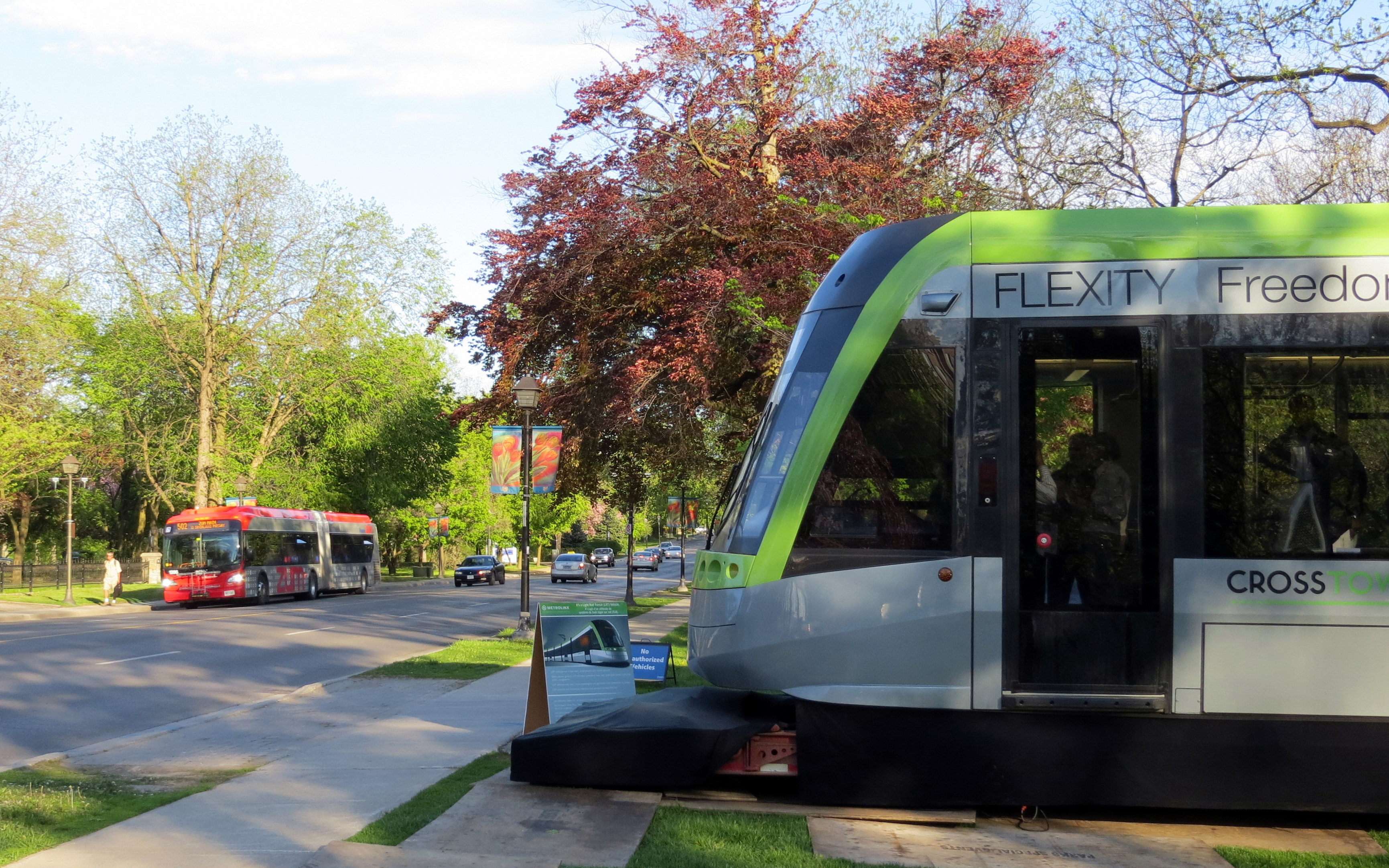
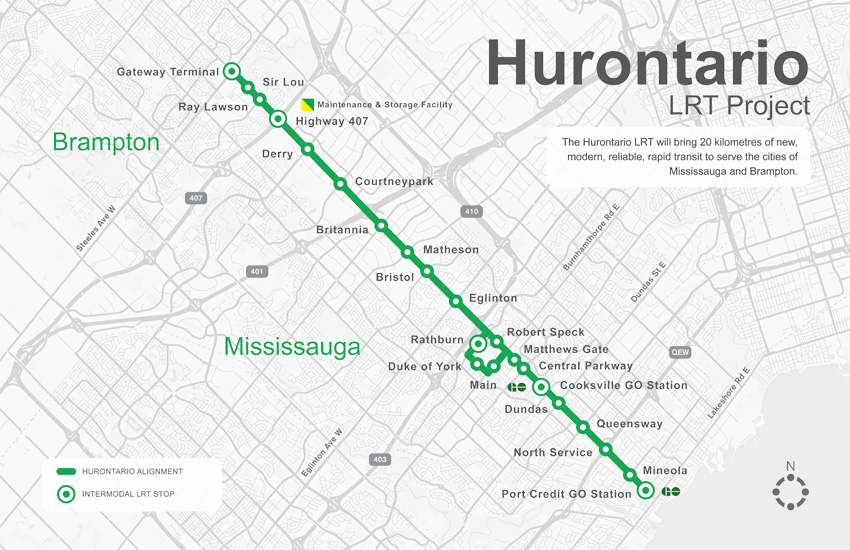
Typical cross-section once the LRT is built. The orange paths are the separated bike lanes, the green paths are sidewalks. Hurontario Street will only have two traffic lanes in each direction. 

    img_8328-001At expressways, like at Highway 407, pedestrians and cyclists still must yield to motor traffic at on-ramps. 

    In another benefit for pedestrians and cyclists, channelized right turns are eliminated along the entire route. Channelized right turns (like the one shown below) are convenient for motorists, but they increase conflicts with foot traffic and are incompatible with lower speeds and safe cycling infrastructure. Their removal also creates new room for streetscaping opportunities.

    4852433218_a9848b9973_o
    An example of a channelized right turn

    The northern terminus of the LRT, at least for now, will be at Steeles Avenue. As Brampton debates other LRT alignments (Kennedy Road and McLauglin Road are indirect alternatives to reach Downtown Brampton), the stop was moved to the south side of the intersection. This is unfortunate: the Brampton Gateway bus terminal, which opened in 2012, was designed to easily connect with the planned LRT stop on the north side of the intersection, with two short crosswalks across southbound Main Street.

    img_8331-001
    Planned LRT terminus at Steeles Avenue, including tunnel between the LRT platform and the Brampton Gateway Terminal. 

    Instead, a more expensive tunnel is required to accommodate transferring passengers between the LRT and buses. Elevators and escalators will provide direct access to the tunnel; crosswalks at Steeles Avenue and Lancashire Lane will also be accessible from the platform.

    The final contract is planned to be signed in mid-2018 and construction should begin in Fall 2018. As the City of Mississauga backs the LRT project, hopefully any change in the provincial government will not jeopardize this plan. Not only will Mississauga (and south Brampton) get a fine new transit service, it will also see a tamer, more urbanized main street.

    And maybe Brampton City Council will come to its senses and extend the transit corridor via the direct, least-expensive, Main Street alignment.

  • A ride from Caledon to Guelph via the Elora-Cataract Trailway

    IMG_5393-001

    On Friday, September 2, I went for an 80 kilometre ride between Caledon and Guelph on what turned out to be a spectacular day: sunny, a high of 23 Celsius and without too much humidity. The summer of 2016 has been exceptionally hot and muggy for long-distance rides, so I’ve done fewer of them. I was lucky to have that Friday off.

    I started my trip in Caledon Village, after taking a GO train to Brampton and transferring to GO Transit’s Route 37 Orangeville bus, which only runs on weekdays. This made the trip very difficult to do on a weekend (I would have to ride 20 kilometres up from Brampton, on busy roads, and up the Niagara Escarpment, otherwise). The racks at the front of GO buses are wonderful for getting out of town (I used GO’s bike racks on similar rides this year), but they tie you to a schedule.

    Map of my ride

    The Elora-Cataract Trailway, owned and managed by Credit Valley Conservation (Cataract to Hillsburgh), and the Grand River Conservation Authority (Hillsburgh to Elora) is one of the best rail trails that I have ever rode. The surface was in near perfect condition along the entire stretch. Wayfinding, including through a gap at Fergus, was great. Barriers at crossings keep motor vehicles out, but are not too difficult to get around for cyclists. And it’s easy enough to get to and from Guelph. But it’s not so easy to get to from Brampton/Caledon.

    After getting off the Route 37 bus in Caledon Village, and after a quick stop there for refreshments, I rode west along Charleston Sideroad for four kilometres to Cataract Road, the only possible route without very lengthy and hilly detours.. That was the most aggravating and dangerous bike ride in a very long time. There’s no paved shoulder, so I rode on the white line demarcating the far right side of the lane. There are several quarries nearby, and Charleston Sideroad was once known as Highway 24. There were many quarry trucks and other large vehicles, most who refused to provide the mandatory 1-metre space that the Highway Traffic Act now mandates. One quarry truck driver blared his multiple times at me, angry and unwilling to share the road.

    image1
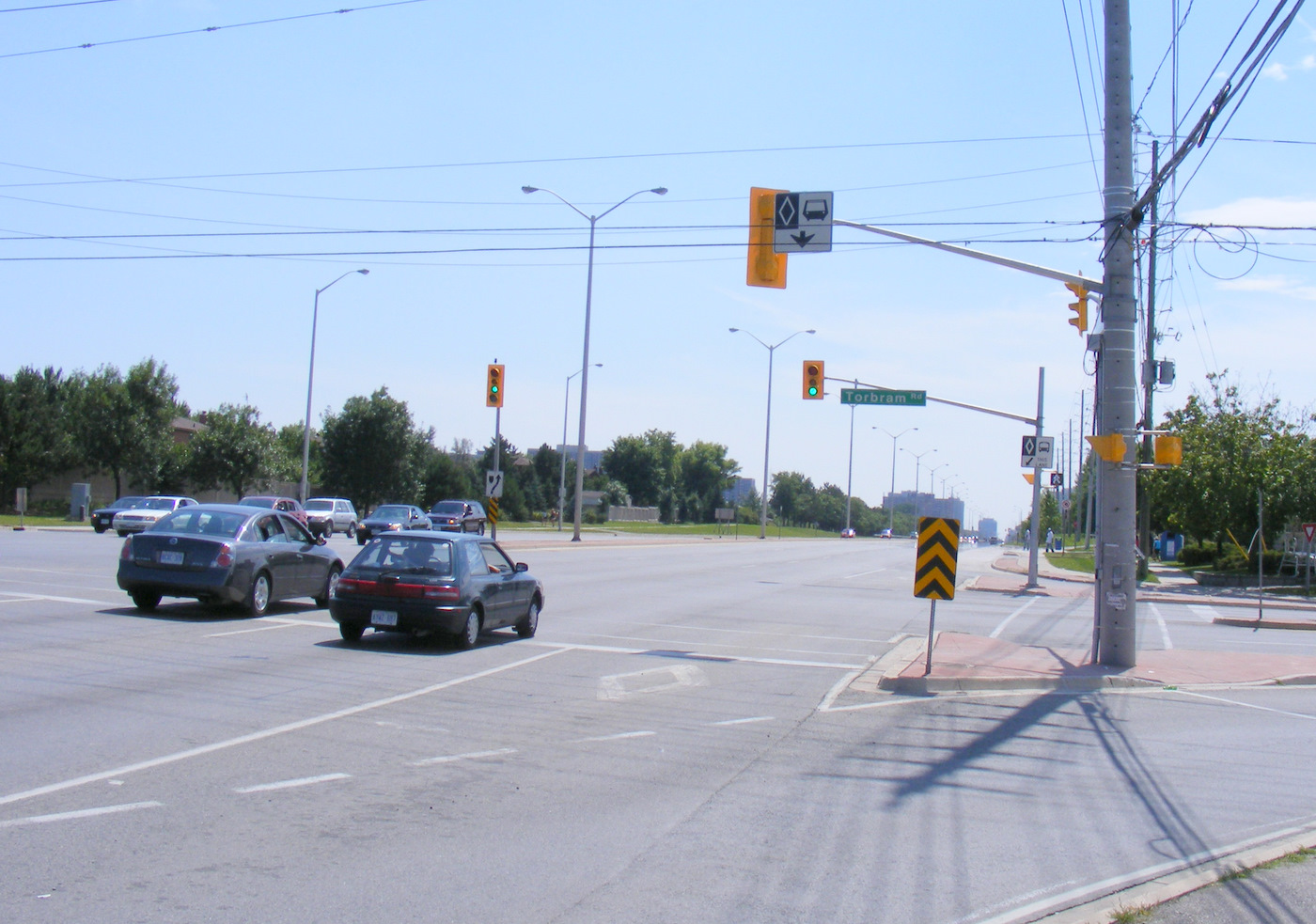
Westbound on Charleston Sideroad

    The dirt shoulder, filled with large stones and debris, is not suitable for cycling. The Region of Peel, responsible for this road, should pave the shoulders as soon as possible. Improved connections to Brampton and the Caledon Trailway should also be identified and built. But once off Charleston Sideroad, the ride quickly became one of my favourites.  (more…)

  • A ride from Peterborough to Uxbridge (Day 2)

    IMG_4092-001Looking west on Doube’s Trestle, between Peterborough and Omemee

    After riding the Lang-Hastings trail on Sunday July 30, I cycled from Peterborough to Uxbridge on Monday, August 1, stopping at Trent University. This is one of my favourite rides in Ontario, having done this route twice before. But this was the first time I rode west towards Uxbridge, rather than east to Peterborough.

    In total, I rode 99 kilometres that day, and given the heat (and the lack of shade), I ended up ending up a little bit dehydrated — and quite tired — at the end of the trip. There are no places to rest or buy snacks or beverages between Lindsay and Uxbridge, so it’s best to plan ahead. Bring lots of water; Lindsay is an excellent place to take a break and have a light meal. At Uxbridge, I had dinner at a local pub before loading my bike on a GO Transit bus back to Toronto.

    There are a number of great rail trails in Southern Ontario, but except in the Lindsay-Peterborough and  Kitchener-Brantford-Hamilton regions, rail trails in Ontario, where they exist, are usually disconnected from each other and difficult to access from Toronto without a car. It makes me long for Québec s Route Verte network of trails and cyclist-friendly roadways.

    (more…)

  • A ride between Peterborough and Hastings (Day 1)

    IMG_4015-001The Trans-Canada Trail crosses the Otonabee River near downtown Peterborough, next to the Canadian Pacific Railway

    During the Civic Holiday long weekend, I spent two days cycling around Peterborough and two of the rail trails that radiate out of it. Peterborough is one of my favourite places to cycle; it is my third time there on two wheels.

    On Sunday July 31, I started by taking the GO Lakeshore East Train, then transferring to the 88 Peterborough GO bus. Every GO bus is equipped with a rack that can accommodate two bicycles, and all non-peak GO trains can take two or four bicycles per coach (there are special bike coaches as well on the Niagara summer weekend service). After getting off the bus in Downtown Peterborough, and getting coffee at one of that city’s many downtown cafes, I biked out to Hastings, on the Lang-Hastings Trail, returning via (mostly) the same route, a 40 kilometre one-way trip.

    I stayed overnight in Downtown Peterborough and biked to Uxbridge via Lindsay the following day (more on that in a subsequent post), making a diversion via Trent University. That one-way trip was almost 100 kilometres in length. At Uxbridge, I had dinner and took a GO bus back to Toronto.

    (more…)