Tag: GO Transit

  • Dysfunction Junction: another Union Station malfunction

    Dysfunction Junction: another Union Station malfunction

    Previously on this website, I discussed the problems with the unsightly, intrusive, and poorly thought-out mess of Jersey barriers plopped in front of Union Station along Front Street. They have not only been an eyesore unbefitting a signature heritage structure, but they have also been difficult for pedestrians to navigate around, especially at the corners of Front and Bay and Front and York.

    The barriers in 2021

    Fortunately, work is just starting on a new system of concrete blocks and bollards to protect the pedestrian plaza and the sidewalks in front of the station. However, this will not be complete until the end of 2025.

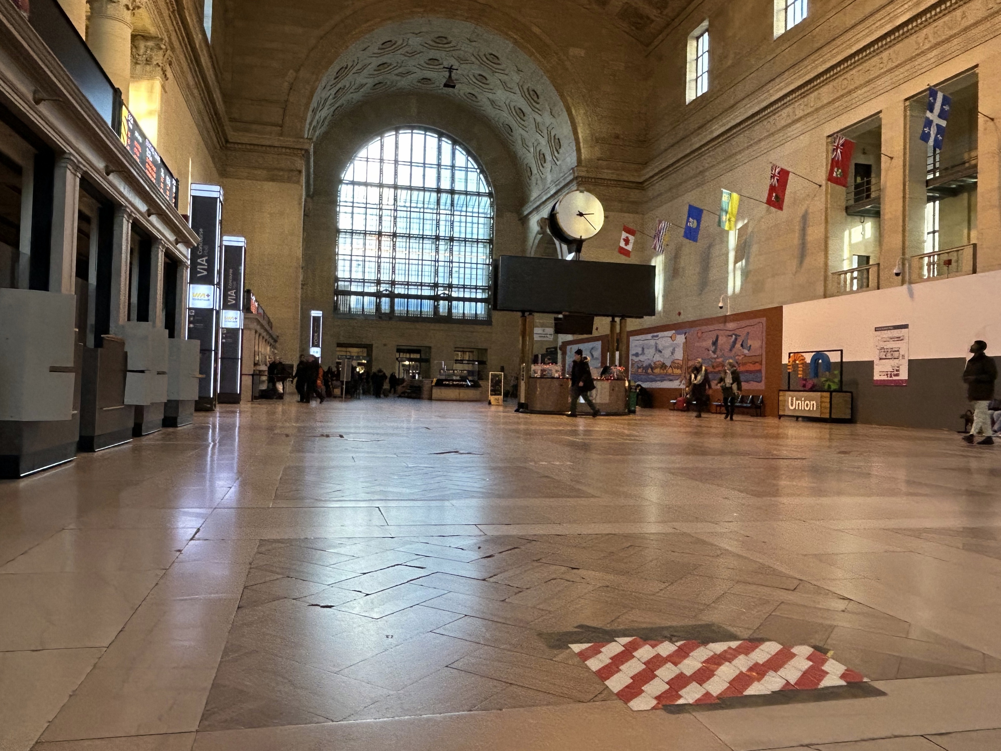
    Inside Union Station, however, a lot has changed in the last few years. In general, pedestrian flow within the station building has improved, especially with the opening of the GO Transit York Concourse, which provides a second access point for regional trains. Flow between subway, train, and shops is considerably improved; there are also a lot more food and retail options befitting a central transport hub.

    Despite new escalators and elevators, accessibility in Union Station remains poor. Though technically, the station is fully accessible to anyone using a wheelchair or other mobility device, the wayfinding is absent in key areas. There is only one small elevator that directly connects the subway level with the Great Hall, UP Express trains, and Front Street. An accessible route is also difficult to find.

    The view after entering the Union Station complex from the TTC subway. The overhead sign shows the way to GO trains, the bus terminal, the Union Market shopping area, Scotiabank Arena, CIBC Square (an office building), York Street, more shops and restaurants, and VIA and UP Express trains.

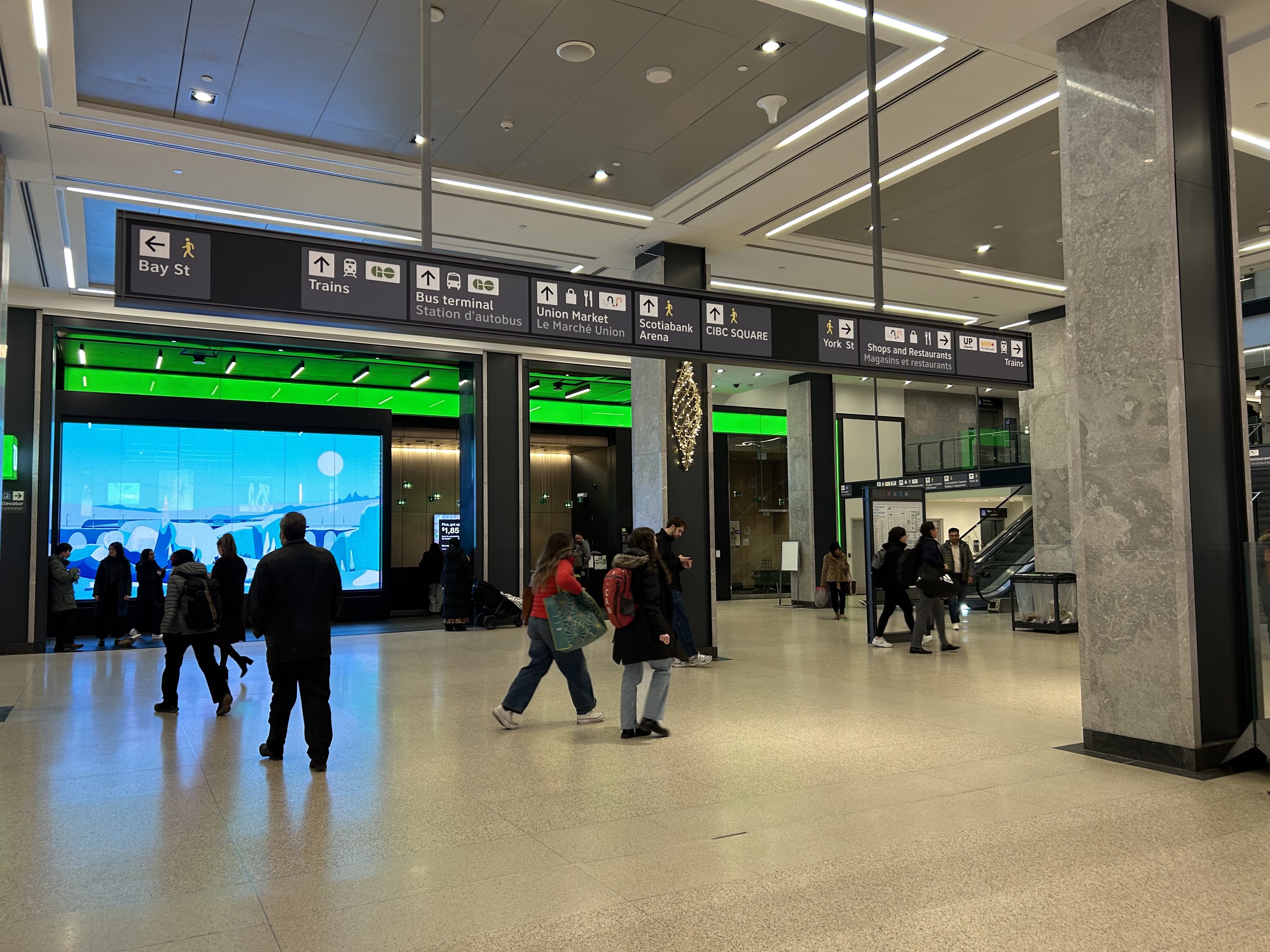
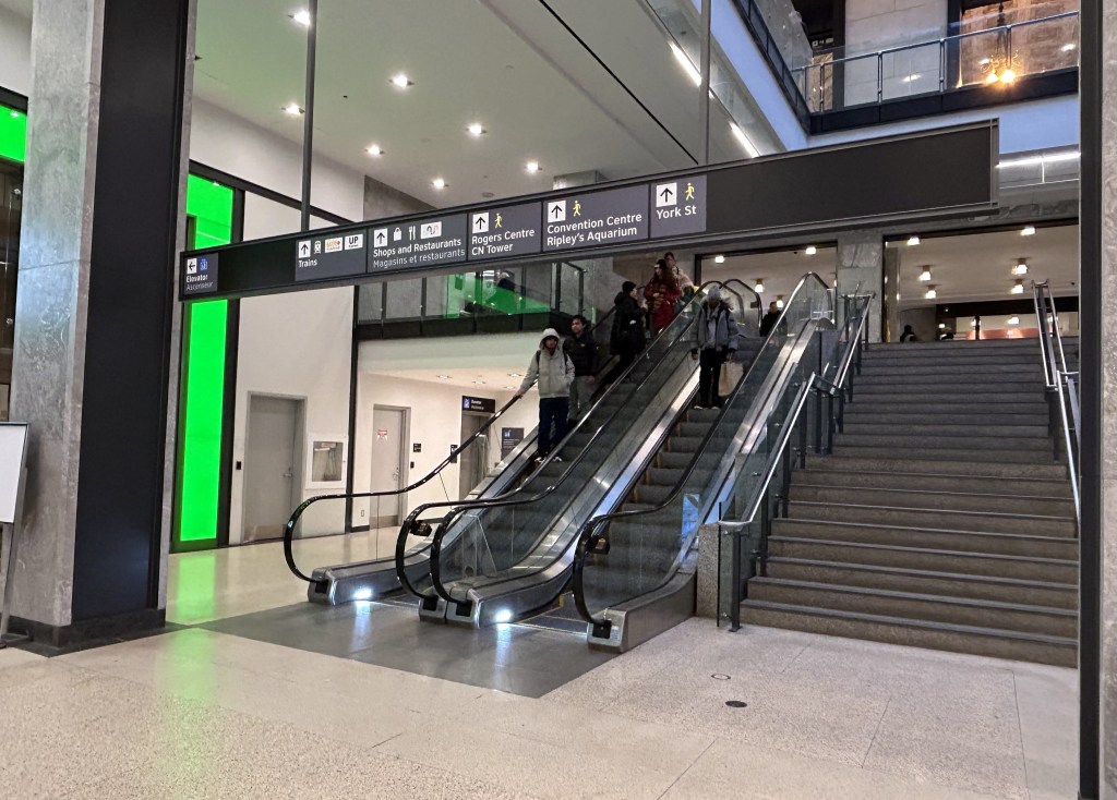
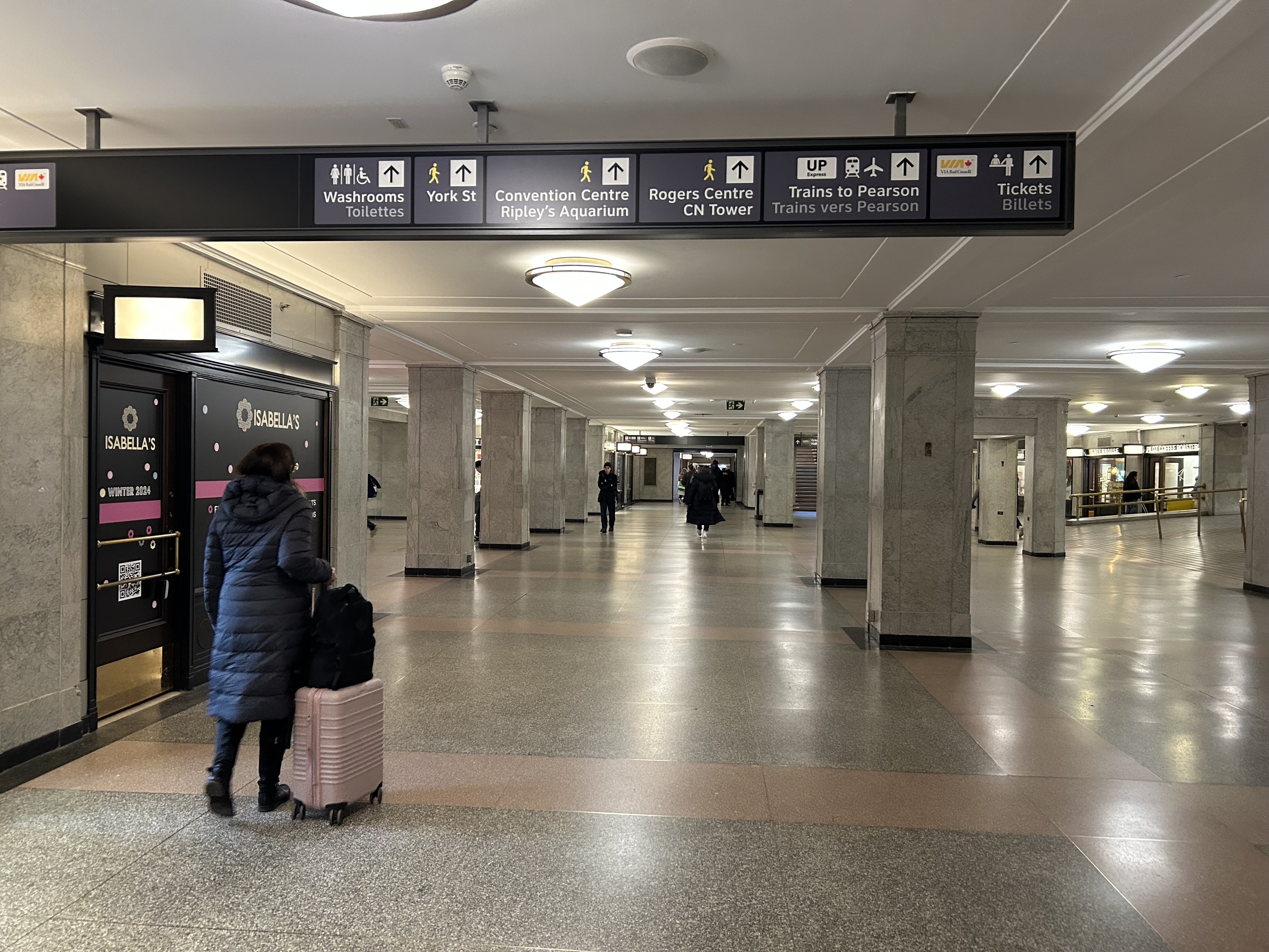
    Imagine entering Union Station from the adjacent TTC subway station with a wheeled device or a mobility aid. There is a large concourse with signs leading forward towards the GO Transit York Concourse along with Scotiabank Arena, the bus terminal, and Union Station shops and food kiosks. To the left is Bay Street, and to the right are a set of escalators and stairs leading up towards VIA Rail and UP Express trains. Behind the stairs and escalators is a single elevator, hidden away.

    To the right is a set of escalators, stairs, and hidden behind, a poorly marked single elevator. These lead towards UP Express and VIA trains, York Street, and attractions such as the CN Tower, the Convention Centre, and Rogers Centre.

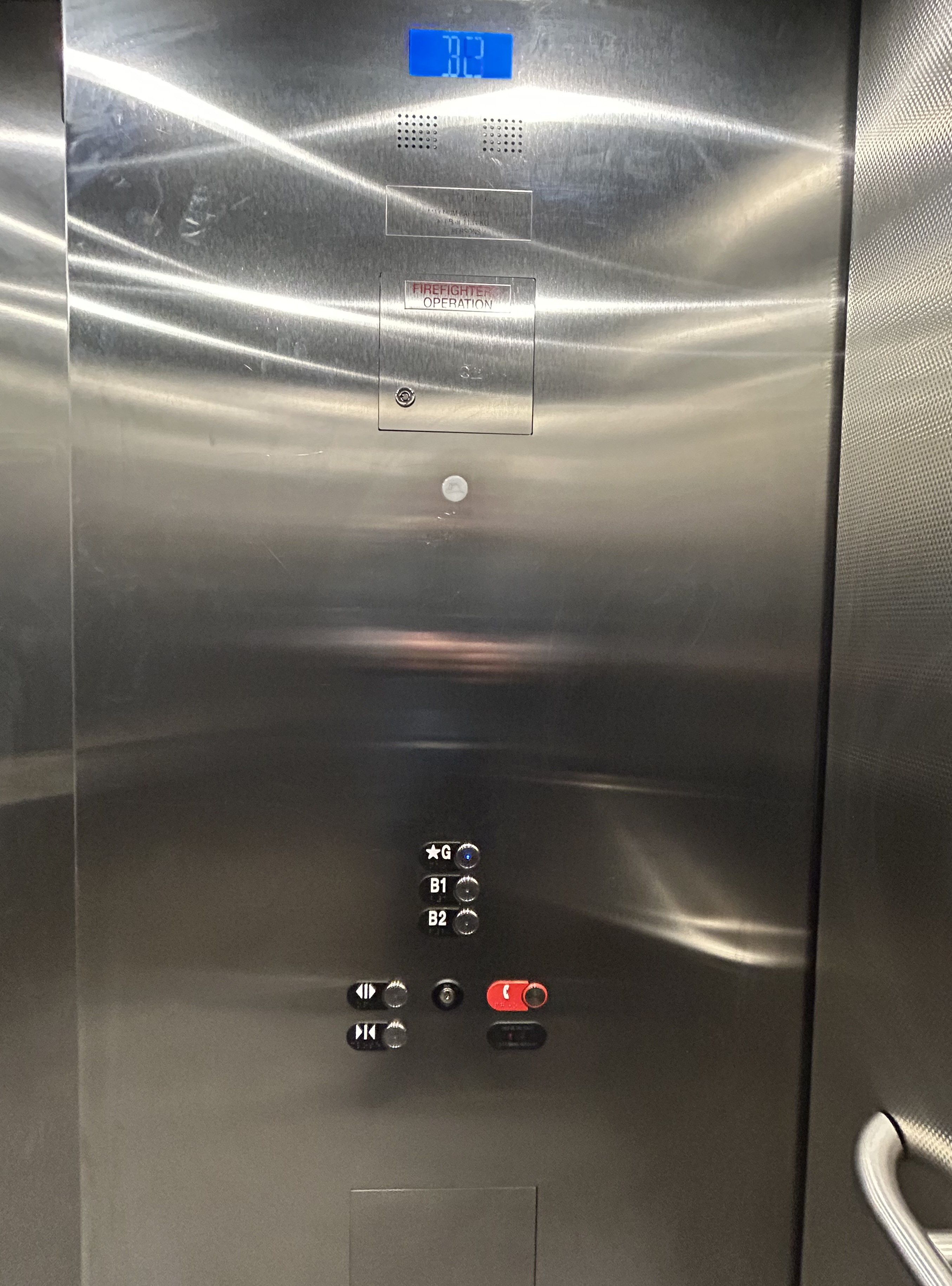
    The elevator provides no information other than a sign that indicates that this is, in fact, an elevator, and this is the B2 level. This is a single, small elevator, which operates slowly.

    The elevator at the B2 (subway) level

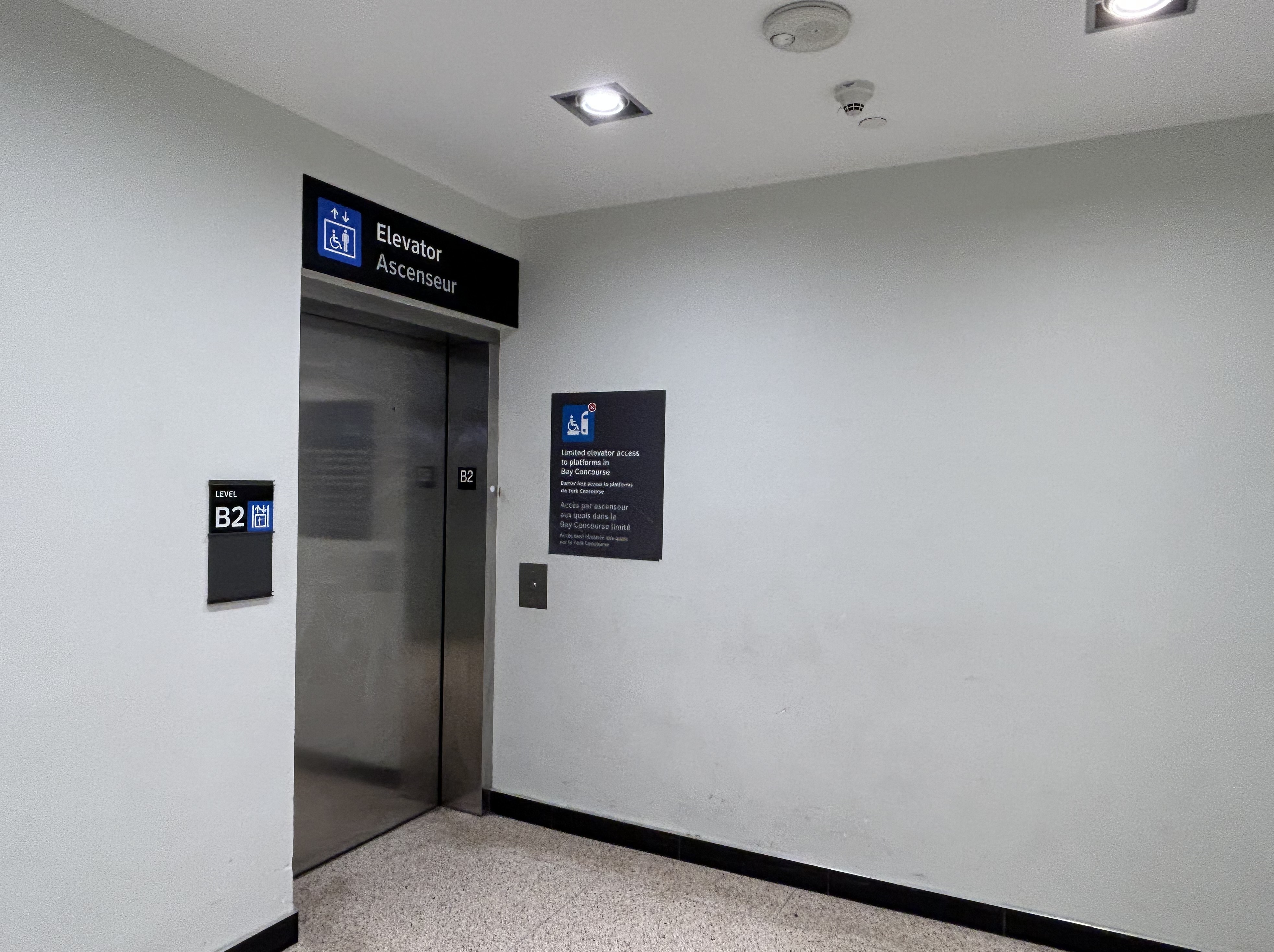
    Once inside the elevator, there is no information other than buttons marked “G”, “B1”, and “B2”. There is nothing to tell the elevator user what is accessible from each floor.

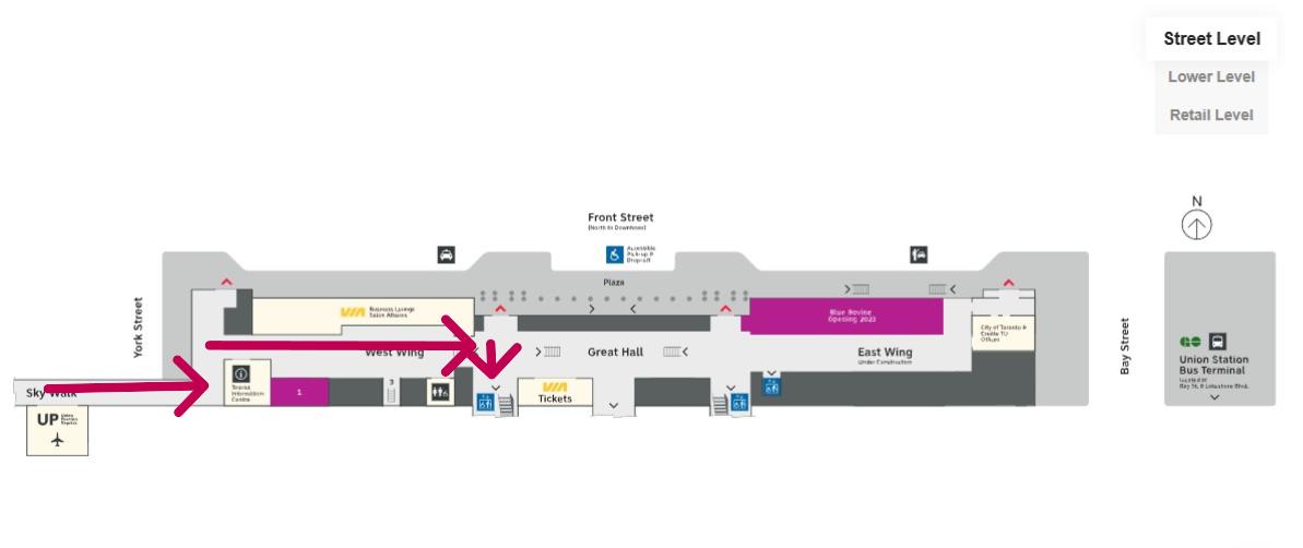
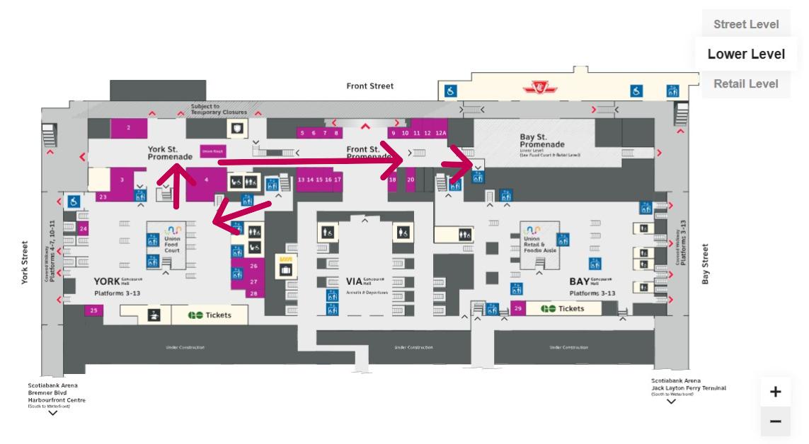
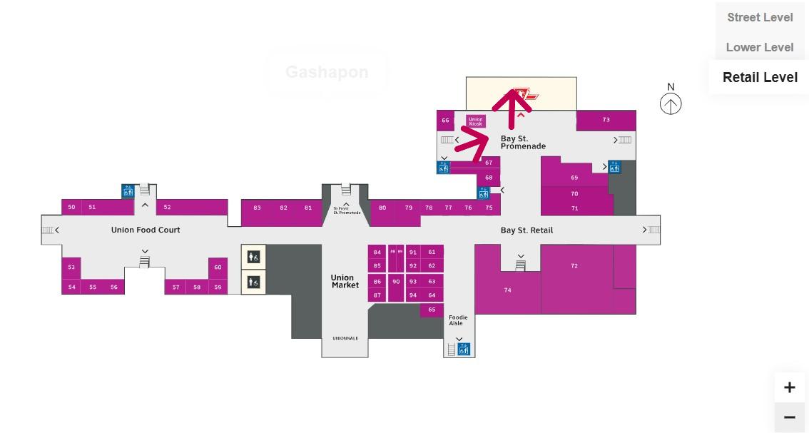
    Confusingly, the official Union Station map directory calls the three levels “Street Level” (G, the Heritage structure including the Great Hall, West and East Wings, along with the path towards UP Express and the Skywalk), “Lower Level” (B1, the GO York and Bay Concourses, the concourse beneath the Great Hall, and the VIA departure area) and “Retail Level” (B2, including the food court, food hall, and connections to the subway). In the elevators, the audio prompts only mention the three level names.

    Inside the elevators, there is no indication what each level is, or where they lead to — the buttons and empty spaces beside them just show G, B1, and B2 levels

    At G level, which includes the Great Hall, VIA Rail departures and business class lounge, and the passage west towards UP Express trains and the Skywalk to the CN Tower and Rogers Centre, the elevator is also hidden behind a wall.

    The only elevator connecting the Great Hall, the lower concourse, and the subway level is hidden, with tiny signage directing travelers to it

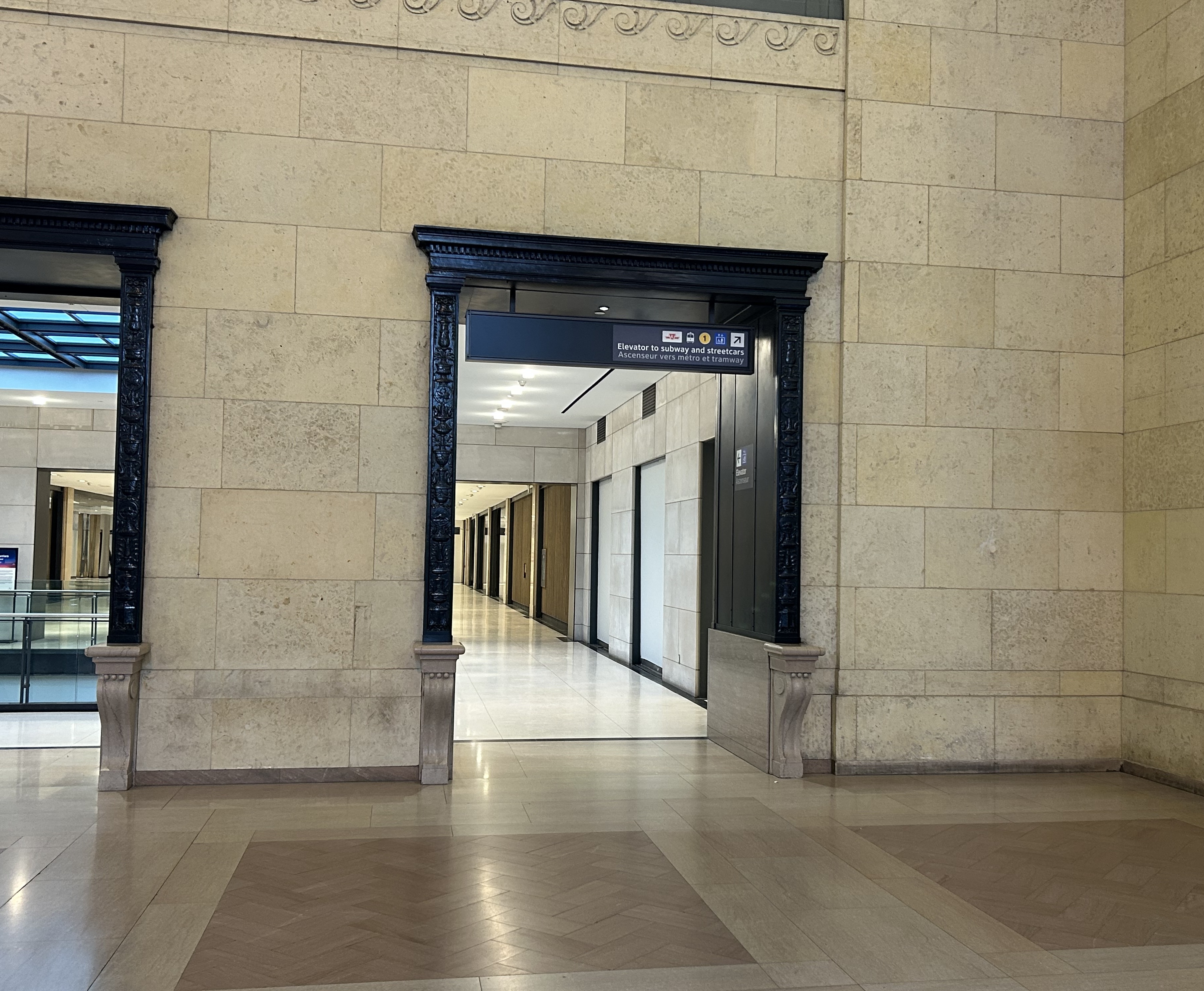
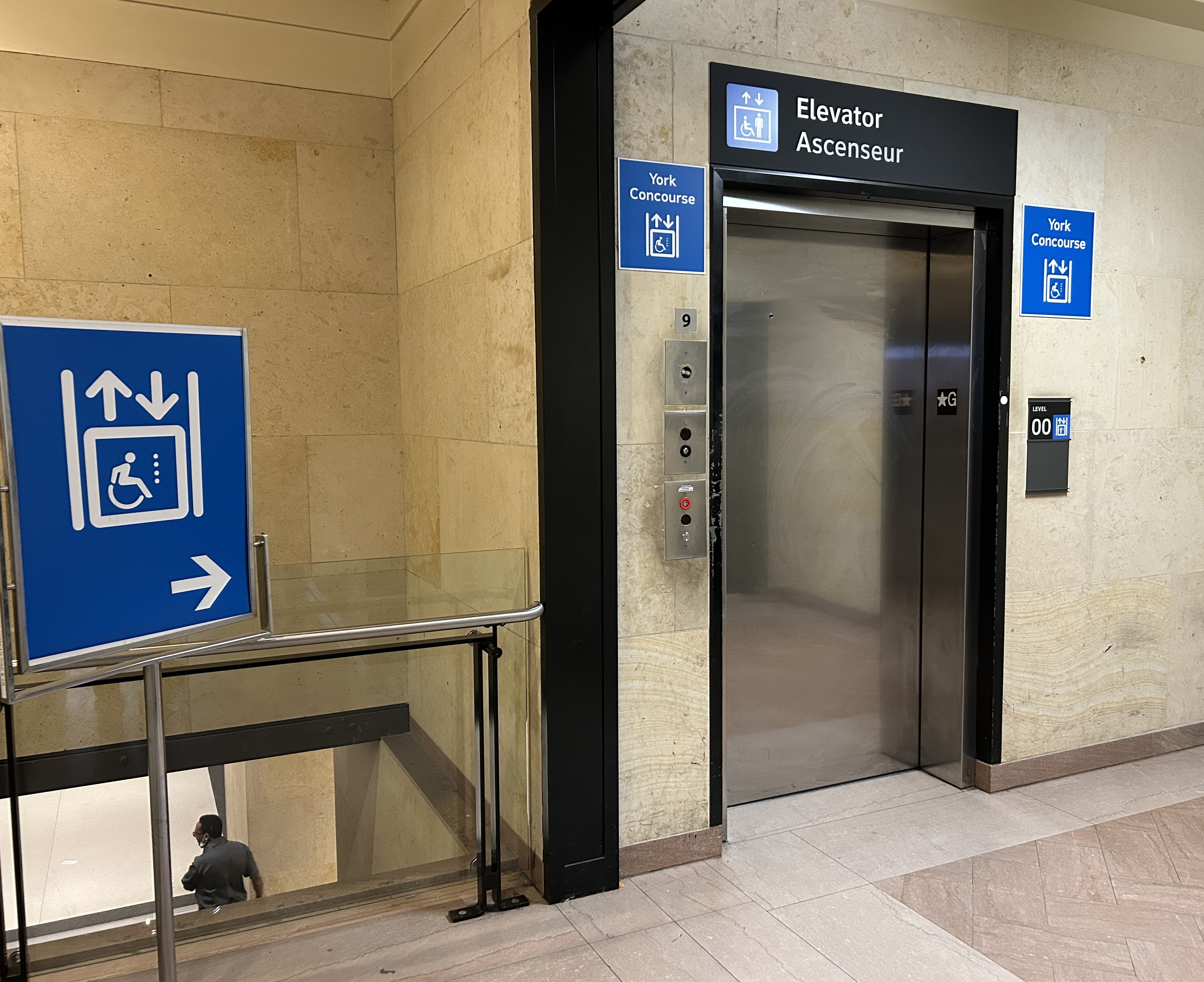
    On the west side of The Great Hall, there is also an elevator, beside the stairway down to the GO Transit York Concourse. This elevator does not serve level B2.

    York Concourse elevator, on the west side of Union Station’s Great Hall

    If the traveler was only connecting from subway to UP Express with a heavy bag, and not using a mobility device, they might decide to take an escalator from the subway B2 level to the B1 level, the lower Union Station concourse originally intended as an arrivals area for intercity trains. However, there is no elevator or upwards escalator to be seen.

    Looking west in the lower concourse, towards York Street and UP Express trains

    If one knew Union Station well, they could make a lengthy detour through the ramps in the VIA Rail area to get to the Great Hall or go around through the GO York Concourse to reach the elevator or up escalator to the Great Hall. But these routes are not marked from the lower concourse area.

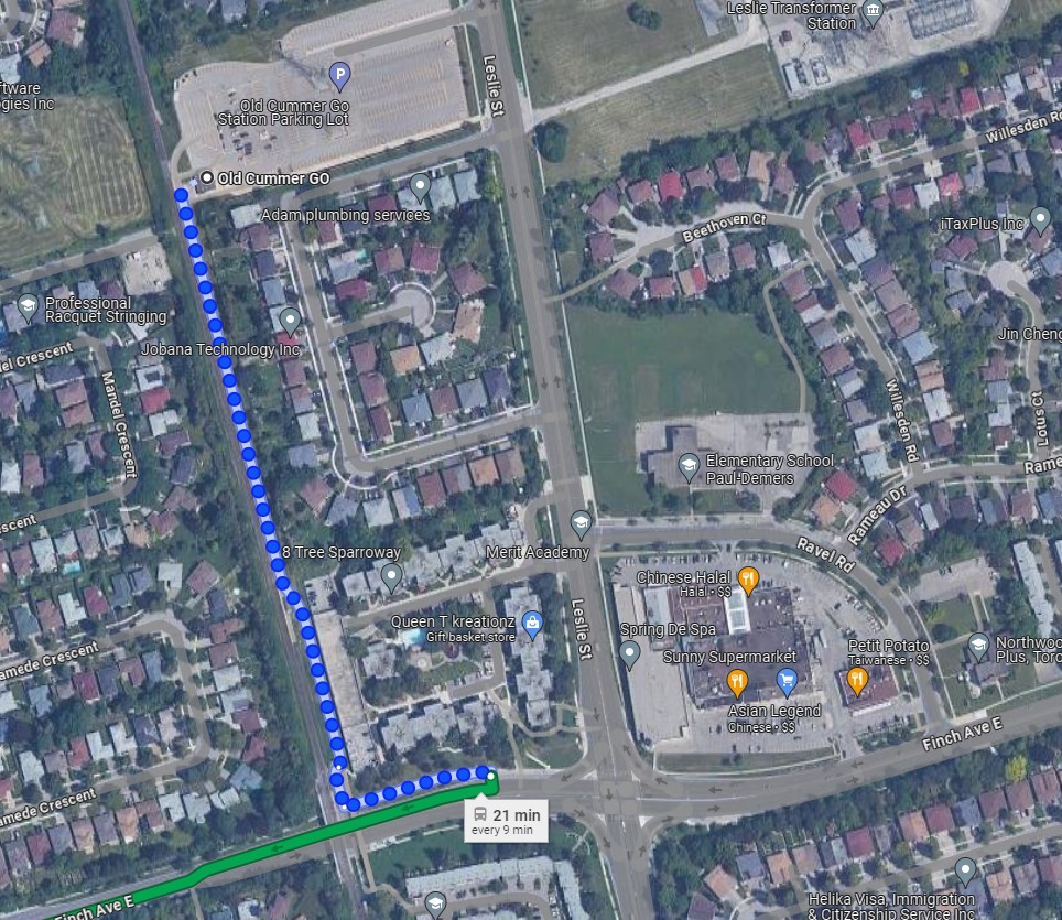
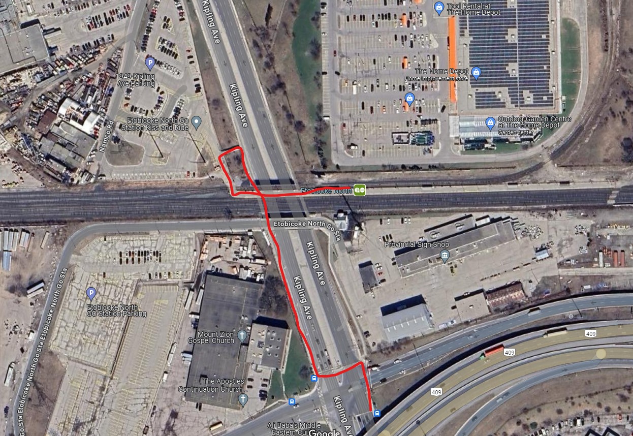
    To show how difficult it can be to navigate the station while using a wheeled device (be it a wheelchair, stroller, or wheeled luggage), I shot this video showing how a first-time visitor getting off an UP Express train from Union Station would try to find the TTC subway entrance.

    Video depicting 9-minute trip at a normal walking speed between the UP Express area and TTC subway station entrance, using first available elevators each time.

    At no point was there any visible signage showing the most direct route for someone requiring a barrier-free path from UP Express to the subway. The maps below show the route I took:

    Route from UP Express to the Great Hall and York Concourse Elevator (Street Level, or G). Arrows are added to mark the route I took in the video.
    Path through York Concourse, lower Union Station concourse (Front St. Promenade) – the B1 Level, and to the second elevator to the Bay St. Promenade (subway level). Arrows are added to mark the route I took in the video.
    Last part of the trip on the Retail Level (B2) to the subway station entrance. Arrows are added to mark the route I took in the video.

    Whenever I travel through an international airport — Toronto Pearson is a good example — I never have to think too hard about where the accessible routes are. Escalators are easy to find. There are banks of two or three large elevators in strategic locations on the ground side of airports, connecting departure and arrival areas, as well as ground transportation facilities. As Canada’s busiest transport hub — busier than Toronto Pearson Airport even — Union Station’s elevators and escalators should be plentiful and easy to find.

    I am aware that there are particular challenges at Toronto Union Station — the City of Toronto controls only the common areas, such as the Great Hall, the retail areas, and the main entrances. Metrolinx, the agency responsible for GO Transit and UP Express, controls the York and Bay Concourses, as well as the UP Express station area. VIA Rail maintains its departures area. There are also heritage elements that need to remain intact, such as the Great Hall. But these issues of ownership and heritage preservation do not excuse the difficulty of getting around with a mobility device or even a wheeled bag.

    Why weren’t multiple elevators installed connecting all three levels, to improve capacity, speed, and provide redundancy in the case of an elevator outage? Why are there not easy-to-find elevators in the West Wing near the UP Express area?

    Judging by the condition of the signature Great Hall itself, there is work yet to be done before Union Station is fully restored to its 1920s grandeur. It should not be too hard to improve accessibility and wayfinding as well. Not just for Torontonians, but for international travelers too.

    The Great Hall floor is still cracked and patched, with electrical tape covering some of the damaged sections

  • A little more coordination, please?

    No matter how you get around Toronto, it’s feels like it’s more difficult than ever

    Getting around Downtown Toronto can be an exercise in frustration, whether you drive, bike, take transit, or drive. Though necessary transit and road construction projects are the cause of much of the congestion, driver behaviour, poor management, and a lack of coordination between various municipal and provincial agencies have only added to the traffic quagmire.

    North-south streets such as Spadina, York, Bay, and Jarvis are jammed by drivers headed south towards the Gardiner Expressway, with lane closures near Exhibition Place only making things worse. Motorists blocking intersections make it difficult for pedestrians, cyclists, streetcars, and through traffic to get across the city centre. Ontario Line construction has closed a portion of Queen Street, while work to rebuild streetcar tracks on York and Adelaide Streets to allow 501 cars to bypass the closure is still proceeding.

    GO Transit is also expanding its rail corridors to allow for more off-peak and express trains, with the long-term goal of having an electrified, frequent, regional rail network that complements and supplements the web of subways, light rail and buses throughout the region. The TTC is also addressing a backlog of state-of-good repair works throughout the subway system, resulting in slow orders, early closures, and weekend shutdowns.

    Meanwhile, people still need to get to places like work, school, conferences and trade shows, concerts, sporting events, social gatherings, festivals, museums, and all the other things that make a city a city. Eventually, with improved GO corridors, the Ontario Line, and the opening of the Crosstown LRT, there will be some redundancy in the transit system that will make planned service closures easier to navigate. But for now, we are stuck with an underbuilt transportation system in a rapidly growing city.

    This makes the coordination of transit closures and projects especially essential so things don’t completely fall apart. Saturday, September 21 was just one example of the failure to do so.

    On Saturday September 21 and Sunday September 22, GO Transit reduced service on the Lakeshore West Line to hourly service on the entire corridor because of work at Long Branch GO Station, where the station is being completely rebuilt for accessibility improvements and future expansion. It also shut down the entire Barrie Line for various construction works along the corridor, with rail replacement buses to Union Station, stuck in traffic on the Don Valley Parkway and Lake Shore Boulevard with all other motorists getting around the Gardiner closure.

    Normally, there are hourly trains as far west as West Harbour Station in Downtown Hamilton, with half-hourly service to Aldershot Station in Burlington. Between Union and Oakville, rail service is as frequent as every 15 minutes during midday and early evenings on Saturday and Sunday. Hourly train service reduced capacity on the inner Lakeshore West line by 75%.

    Compounding the problem was the total closure of the Gardiner Expressway between Highway 427 and the Don River between Friday evening and Sunday morning for routine maintenance (the Gardiner and the Don Valley Parkway are regularly closed twice a year for repairs). Many people who might have otherwise driven into the city would have taken GO Transit instead, normally a very good idea. Though none of Toronto’s professional sports teams were playing at home on Saturday, there was still a Shane Gillis stand-up comedy performance at Scotiabank Arena, and a Rainbow Kitten Surprise concert at Ontario Place.

    Also, to add insult, the Lakeshore East trains between Toronto and Oshawa were not through-running with the Lakeshore West trains and were operating on a modified schedule. I was travelling east of Toronto on Saturday, making a few stops in Durham Region. As I arrived back from Whitby on Saturday afternoon on a train that normally connects onward westbound train at Union Station, we were treated to the sight of the hourly Lakeshore West train just pulling out. It couldn’t have even waited 2-3 minutes to allow passengers to make the cross-platform connection. That resulted in other passengers complaining to GO staff in the concourse, who were not that helpful.

    Tweet from Alan Deschamps, reporting on a full GO train arriving at Long Branch at 6:21 PM on Saturday Sept 21, with the customer service ambassador (CSR) telling waiting passengers to not board and to wait for the next train in an hour

    In the early evening on Saturday, a jam-packed eastbound GO train on the Lakeshore East train was not accepting any passengers at Long Branch or Mimico station because of overcrowding. Waiting passengers were told to wait an hour for the next train.

    One would think that Metrolinx (GO Transit’s parent agency) and the City of Toronto would coordinate their construction schedules to avoid such problems. However, not even the City of Toronto can figure this out. Back in June of this year, the TTC replaced the 509 Harbourfront and 511 Bathurst streetcars with buses for a week for minor overhead work on Fleet Street. The timing coincided with the massive Collision tech conference at Exhibition Place, which resulted in overcrowded shuttle buses and unreliable service. Had the TTC checked with anyone at the city’s economic development office or with Exhibition Place (another city agency), this work could have easily been rescheduled.

    Overloaded 509 Harbourfront bus shuttle on Queen’s Quay in June 2024

    Though coordination of transit closures and construction projects with major events and parallel roadworks will not solve Toronto’s road and transit congestion problems, it will at least reduce some of the frustration of getting around. The poor customer service at GO Transit will certainly make riders question if they will be able to rely on the service in the future.

    Of course, there is one measure that won’t help but still will be implemented by the provincial government later this fall: a prohibition on new bicycle lanes if they take road space from motorists. Despite blocked bike lanes, aggressive drivers, and an incomplete cycling network, it is still the most reliable and fastest mode for many shorter city trips. Along with major transit improvements and construction coordination, cycling is one of the solutions to getting around Toronto.

  • A review of Metrolinx’s April 2024 service changes

    A review of Metrolinx’s April 2024 service changes

    With a GO train serving as a backdrop, Premier Doug Ford, along with Transportation Minister Prabmeet Sarkaria, announced major changes to GO Transit service, with 300 new weekly trains (a 15% service increase). The service changes will take effect on Sunday, April 28, 2024.

    Though most new trains will be added on the Lakeshore West, Lakeshore East, and Kitchener Lines (the Milton Line gets just one additional weekday round trip in the peak direction), the media event was held in Milton, where a byelection was called to replace outgoing PC MPP Parm Gill. With a competitive race between PC candidate Zeeshan Hamid and Liberal candidate Galen Naidoo Harris, the choice of venue made it an especially political event.

    News of the pending service changes was publicized in regular Metrolinx email newsletters in March, but was since taken down, likely to allow for the news to be shared first by the premier and minister of transportation. It is quite clear that Metrolinx is entirely beholden to the provincial government these days, where communications are tightly controlled by its political masters.

    The new GO Transit schedules are now available online. Though there is plenty of good news, some of the added trains are merely restoration of previous service levels. Meanwhile, there will be a significant service cut for two Toronto stations.

    Lakeshore Corridor

    Fifteen-minute train service returns on the busy Lakeshore line on weekend afternoons and evenings, between Oshawa and Oakville Stations only. Service will still run every half-hour on weekdays, weekend mornings, and to Bronte, Appleby, Burlington, and Aldershot Stations, and every hour to West Harbour GO in Hamilton.

    However, weekend 15-minute service starts late in the afternoon. Frequent service from Oakville to Union starts at 2:30 PM Saturdays and Sundays and at 3:14 at Union Station. This additional service starts too late for family day trips to the city or for getting to afternoon Blue Jays games.

    Bus route 18K, which operates between Aldershot, West Harbour, St. Catharines, and Brock University, is renumbered to Route 11.

    Milton Corridor
    Map of Route 21

    There will be one new peak-period round trip leaving Milton at 6:43 AM and leaving Union at 4:10 PM.

    More importantly, Route 21 will return to its previous routing, operating directly into Union Station Bus Terminal. When I wrote about the April 2023 changes, I commented that the changes simplified the complicated Route 21 while improving reliability and predictability for Milton Line passengers. However, the changes proved to be unpopular, with poorly timed connections between buses and trains.

    But with the Gardiner Expressway down to two lanes between Dufferin Street and Strachan Avenue for long-term construction, and with downtown Toronto’s traffic, I am wondering how much better the ride will be.

    Route 21A, which ran between Milton and Oakville, will be replaced by Route 22, which offers much more limited service — every two hours, weekdays only. Route 21A offered useful connections to GO buses at Trafalgar Road Park & Ride for Highway 407 services to McMaster University, Downtown Hamilton, Square One, and beyond. It is a shame to see that service reduced, though perhaps Milton Transit should begin serving it.

    Kitchener Corridor and UP Express
    New UP Express service pattern

    The good news? There will be new weekday half-hourly train service between Bramalea and Union Stations during midday and early evening periods. (Hourly service between Bramalea and Union will remain in the counter-peak direction.) There are no changes to rail service between Kitchener, Mount Pleasant, or Union Station and only minor changes to connecting GO buses. Not all trains will stop at Etobicoke North, which only has one platform.

    The bad news? UP Express service will be split into express and local services, with non-stop service between Union Station and Pearson Airport every 30 minutes, and local trains every 30 minutes stopping at Bloor and Weston. Both local stations will see improved weekday GO service, but this still amounts to a service cut, especially at Bloor, an important connection to the Line 2 Subway and local TTC services. This is also at a time when the connection between Dundas West Station and Bloor Station is finally being improved.

    Other changes

    Weekday evening train service will be restored on the Stouffville Line on April 28.

    Elsewhere, there are minor schedule adjustments — it’s always a good idea to check your trip before you depart.

    One last thing worth commenting about is a brand new, well-designed GO Transit bus map that clearly shows each route and how they connect to the rail network. Bus routes are sorted into “core” and “train support” services, a useful distinction.

    My only criticism is that they should show frequency or level of service — some “train support” routes run hourly or better, seven days a week (like Route 30) while some of the “core” routes do not operate evenings and weekends.

    Regional bus map
    Finally

    Apart from my observations and criticism above, I would have liked to have seen more changes to the bus network. For example, service to Peterborough remains too slow, while there should be weekend service between Kitchener, Guelph, and Hamilton. Hopefully, there will be more changes in September.

  • The other barrier to GO-TTC transfers

    The other barrier to GO-TTC transfers

    A TTC bus and GO train at Eglinton GO Station

    On Monday, February 26, the new Ontario One Fare Program will take effect. Transit riders who previously had to pay a second fare when transferring from GO Transit or suburban transit agencies (York Region Transit, MiWay, etc.) to the TTC, will now benefit from a free transfer. Passengers will also be able to transfer free from the TTC to suburban buses or get the TTC fare discounted if transferring to GO Transit.

    The new fare program, subsidized by the provincial government, is only available to customers who pay using a Presto card or other contactless payment options (credit card, debit card, mobile app). It is also not applicable to and from UP Express.

    This is good news for many transit users, and it fixes several flaws in the existing fare structure. For example, when GO Transit moved its Highway 407 buses — originally designed to ferry commuters to York University — to Highway 407 Station in Vaughan, students and staff had to pay the TTC fare just to go two stops or endure an unfriendly walk. For a short time, there was a $1.50 discount for GO-TTC transfers, but that was allowed to expire under the Ontario PC government.

    The elimination of the double fare will also benefit transit passengers who live or work near the border of Toronto and York, Peel, and Durham Regions. On the boundary between Markham and Toronto, it is common to see lots of bicycles locked up at bus stops along or near Steeles Avenue at TTC stops. These bicycles are owned by York Region residents who ride south to avoid the double fare and benefit from one less transfer. Once the new free transfer comes into effect, it will be interesting to see if there is a bump in YRT ridership.

    Bicycles parked on the south side of Steeles Avenue, February 2024

    Though the new free TTC transfer should — at least in theory — eliminate a barrier to integrating GO Transit with local transit, the TTC really isn’t set up to feed the GO Transit rail network, nor are many GO stations set up to serve TTC riders. There are historical reasons for these poor connections, but they will need to be fixed.

    GO Transit started off in 1967 as a commuter rail pilot project, with the Government of Ontario (the “GO” in GO Transit) looking to keep costs down in case the three-year experiment was unsuccessful. Many station sites were selected for their proximity to major roads and highways and parking access. As the service was intended to attract suburban commuters from their cars and mitigate the need for expensive highway widenings, transit access was only a secondary consideration. The initial Lakeshore Line exceeded expectations and so GO added new lines to Georgetown (1974), Richmond Hill (1978), Milton (1981) and took over CN commuter operations to Bradford/Barrie and Stouffville.

    An example of this era of GO Transit station placement is Old Cummer Station, which opened in 1978. It was built where the Richmond Hill Line crossed the Finch hydro corridor, with land underneath the transmission lines easily paved over for parking. A walkway leads south to Finch Avenue, where one can connect to TTC buses, but the station building and the platform are oriented towards the parking.

    As the Richmond Hill Line only operates during the peak periods, and is the only GO train service not destined for service expansion, this is not a major problem.

    In the 905 suburbs, such as Mississauga, Brampton, Oakville, and Whitby, local transit connections are often quite good. For decades, commuters in those cities have benefitted from discounted or free fares on local transit when heading to or from GO rail stations (with Presto, connections to and from GO buses are now also free). Many transit agencies, particularly Durham Region, Oakville, and Burlington along the Lakeshore Line, centre their bus systems around the GO stations. Brampton built its downtown bus terminal adjacent to the GO station in 1989, and in 2023, Metrolinx opened a new bus terminal at Bramalea Station, allowing for easy transfers between buses and trains.

    Bramalea GO Station bus loop

    On the other hand, the TTC bus network was designed around the subway network, with nearly every route serving at least one rapid transit station. Though TTC buses would pass by GO stations, transfers between the two were limited because of the extra fare and the infrequent GO services compared to the subway. The only TTC loop on GO station property is at Rouge Hill Station, though Exhibition Loop and Long Branch Loop are short walks to GO station entrances.

    Entrance to Guildwood GO Station at Kingston Road. TTC passengers looking to connect with GO trains must cross a busy intersection than then walk through a parking lot to reach the station building.

    As GO Transit continues to expand, and fare integration finally becomes a reality, there is both an opportunity and a need to change. Though there are plenty of examples of poor GO-TTC connections, there are also some promising moves towards physical integration between the two systems.

    The worst GO-TTC connection: Etobicoke North

    Red path shows walking route between northbound 45 Kipling bus stop and Etobicoke North GO platform

    Etobicoke North station opened in 1974 as part of the Georgetown (now Kitchener) GO Line. The station and parking lot were built on Ministry of Transportation property and in a hydro corridor. Though the frequent 45 Kipling bus passes under the rail corridor, the transfer between bus and train requires crossing two sides of the busy Kipling/Belfield/Highway 409 off-ramp intersection, continuing on a narrow sidewalk, and climbing a flight of stairs before reaching the main walkway to the station platform. Though a passenger could save a lot of time by transferring to the train (especially as it now runs seven days a week), the long and uncomfortable transfer makes this very uninviting.

    A new station at Woodbine Racetrack is proposed, but work has yet to begin. The station at Etobicoke North will eventually have to be closed and demolished to make way for track expansion required for 15-minute GO service. There’s an opportunity to build a great transit hub at Woodbine, especially with an extension of the Finch West LRT.

    Metrolinx map of the potential Highway 27-Woodbine Station

    An accessibility failure: Scarborough GO

    Scarborough GO Station, from St. Clair Avenue East

    Scarborough GO Station, near St. Clair Avenue East and Kennedy Road, is located where the GO Stouffville Line splits off from the Lakeshore Line; the station was originally known as Scarborough Junction, as it was the point where the Midland Railway of Canada met the Grand Trunk Railway. (This is where Midland Avenue gets its name from.) The station building and parking lot is located on the south side of the tracks, accessible from Midland and Reeve Avenues. A walkway on the north side of the station leads to St. Clair Avenue East, but it involves several staircases and is not fully accessible to the street, where the 9 Bellamy and 102 Markham Road buses stop.

    The Scarborough Junction Masterplan development proposal includes a new connection to St. Clair Avenue as part of a transit-oriented mixed-use community. It promises to better integrate GO and TTC services but will likely be several years before construction begins and even longer until a fully accessible connection is possible.

    A more typical transfer: Agincourt GO

    Agincourt GO Station, looking northeast from the south side of Sheppard Avenue East

    Agincourt Station, in service since 1871, was taken over by GO Transit in 1982. The station building was always located several hundred metres north of Sheppard Avenue, and even in CN commuter rail days, featured a small parking lot. In 2012, an overpass was built separating Sheppard Avenue from the tracks; this allowed for a future Sheppard East LRT as well as train service expansion (a grassy median marks where the light rail line was planned to go). The TTC bus stops are located where the parking lot driveway exits onto Sheppard at a signalized intersection.

    Unfortunately, the station platforms were not moved south on the overpass, reducing the walking distance between the train and bus stops and sidewalks on Sheppard Avenue. Though there’s a proper walkway between the TTC stops and the station itself, the station remains oriented mainly to the surface parking lot. Transfers are definitely possible, but not particularly easy.

    The nearest eastbound TTC bus stop to Weston GO/UPX Station, located a five-minute walk to the east

    Similar situations exist at Weston GO/UP Express station, where the TTC stops are several hundred metres away from the GO platforms at Weston Road and Lawrence Avenue, and at Oriole Station, where the walk from the GO platform to Leslie subway station is still unnecessarily lengthy and also requires crossing a busy intersection.

    Milliken GO: A promising direction

    A Steeles East TTC bus stops at Milliken GO Station

    As part of the Stouffville Line corridor upgrades (which includes double-tracking the line between Scarborough Junction and Unionville) Milliken GO Station was recently rebuilt. It now features a new grade separation over Steeles Avenue, along with two new pedestrian overpasses on either side of the tracks. Though the station building is still oriented to the parking lot south of Steeles Avenue, the new layout provides excellent connections to buses on Steeles Avenue, including TTC routes 53/953 Steeles East, 43A Kennedy, and 57 Midland. Entrances on both sides of Steeles Avenue offer stairs and elevators to platform level.

    TTC bus stop, separated bike lane, and access to GO trains

    The one issue at Milliken Station — as with many GO stations — is that the wayfinding from platform level to TTC buses is completely missing. Ideally, signage should indicate not only the route to TTC buses, but the connecting bus routes as well.

    Unfortunately, signage at Milliken Station does not indicate TTC bus connections

    A new GO Station, nearly three kilometres to the south, will feature a similar layout. As platforms will extend over Finch Avenue, transfers between train and bus will be even more convenient at Finch-Kennedy as they are at Milliken. With minimal parking and optimized transit connections, this should be the norm as GO Transit transforms into a frequent, regional rail network. As of February 2024, preliminary work has started on the grade separation.

    Rendering of the future Finch-Kennedy GO Station

    Concluding thoughts

    The new Ontario One Fare Program is a long-overdue step towards integrating the Greater Toronto and Hamilton Area’s disparate transit agencies and addressing unfair tariff boundaries at Steeles Avenue and elsewhere. It also recognizes GO Transit’s future as a regional rapid transit network that not only connects the suburbs to Toronto, but a solution to providing better transit within the city as well.

    There are some challenges that still need to be addressed. As I’ve said several times on this website, GO Transit’s fare structure needs a rethink, especially as its fare-by-distance fare system overcharges passengers on the Kitchener, especially compared to its northern rail corridors.

    Most importantly, TTC-GO transfers should be simple, easy, and direct. Happily, there is some momentum to making this happen — Downsview Park Station, opened in December 2017, is a great example of physical integration between GO and TTC — but as shown above, there is much work to be done.

  • A visit to GO Transit’s New Old Elm Station

    A visit to GO Transit’s New Old Elm Station

    The new Old Elm Station in Stouffville, Ontario

    On Monday, October 30, the new Old Elm GO Station opened in the town of Whitchurch-Stouffville, northeast of Toronto. Located two kilometres away from Stouffville’s small downtown core, Old Elm is focused on park-and-ride passengers arriving from nearby communities such as Goodwood, Uxbridge, Port Perry, Beaverton, and from within Stouffville itself.

    The new station is relatively simple, with a covered platform, a bus loop with several bays directly adjacent to the single platform, heated shelters, and a 673-spot parking lot. As a relatively quiet station with limited train service, there is no indoor waiting room or ticket office.

    The bus loop is directly adjacent to the train platform

    Though train service is limited to weekday rush hours and a few evening and weekend departures, there is regular GO Transit bus service connecting Uxbridge and Goodwood to Old Elm Station, and onwards to midday and weekend train connections at Mount Joy or continuing to Toronto Union Station. There are no York Region Transit connections at Old Elm.

    The Lincolnville layover yard, which was also the Lincolnville/Old Elm station location until October 2023

    Previously, Old Elm Station was located a few hundred metres away, northeast of the Tenth Line/Bethesda Side Road intersection at the Lincolnville layover yard, where Stouffville Line trains continue to be stored overnight and weekends. That station, originally named Lincolnville for a nearby hamlet, was opened in 2008 to accommodate service expansion and relieve the small station at Stouffville, which had no room for a bus loop or additional parking. Since Lincolnville was a yard terminus, passengers had to walk across tracks to reach the next departing train, and each departing and arriving train had to crawl through the yard before reaching the mainline. (As Georgetown GO Station is also within a layover yard, trains passing through on their way to and from Kitchener must also crawl through. A new layover yard near Heritage Road in Brampton will allow for a rebuilt Georgetown Station with faster arrivals and departures.)

    Lincolnville Station was confusingly renamed Old Elm in 2021, even though that new name referred to a tree on the new station site that didn’t open for two more years. Had the new name taken effect with the location change, it would have made more sense.

    The new station site, located outside of the Lincolnville yard, allows for smoother and faster arrivals and departures, shaving several minutes off the trip for passengers to and from Lincolnville.

    The station’s namesake, an old elm tree on the south end of the GO Transit property

    Though Lincolnville/Old Elm is located in the Greenbelt, and the station is unable to support transit-oriented urban development, there was a need for the layover yard. Adding a small, auto-focused station was quite sensible. This is no Garage Mahal.

    The one unfortunate feature is the complete lack of active transportation access beyond the station property. Though Metrolinx built a wide concrete walkway from Tenth Line to the station platforms, there are no sidewalks, no crosswalks, and no pedestrian signals at either the main entrance or the bus loop entrance, which are both signalized intersections. Instead, there are “no pedestrians” signs facing all directions.

    “No pedestrians” sign placed in front of the new concrete pathway into Old Elm Station

    Once on Metrolinx property, though, there is a wide pathway, presumably for cyclists and pedestrians. Interestingly, the sign below shows that cyclists should keep to the left, on the wide pathway, while pedestrians are directed into the grass to the right.

    Beyond the “no pedestrians” sign at the intersection, another sign instructs cyclists to keep to the left and pedestrians to the right – into the grass

    I doubt Metrolinx intended for the hostile intersections to forbid any pedestrian activity. I note too that despite the rural locale, there are several neighbouring homes and businesses along Tenth Line and Bethesda Side Road. The nearest subdivision is less than a 15-minute walk away, a healthy stroll’s distance. A new residential development, Elm Villa, is planned for the site immediately to the south of the bus loop. Tenth Line is maintained by the Town of Whitchurch-Stouffville, so it is likely they are responsible for the oversight. Still, it is not a great look.

    No crossing at Old Elm

  • The case against transit advertisement wraps

    The case against transit advertisement wraps

    A Go Transit double decker bus completely covered by a vinyl wrap, with the exception of the front windows and entrance door. The wrap advertises the transit agency’s wifi and music streaming gimmick.

    Apart from unscheduled short-turns, lengthy delays, or missed transfers, the thing that bothers me most about riding buses or streetcars is an obstructed view caused by a vinyl advertisement wrap.

    Though transit advertisements have been around almost as long as there have been transit services, these advertisements have generally been limited to posters and cards mounted outside the vehicles, or placed inside, above the windows or beside doors. Advertisements have long been placed inside train and subway stations, and in outdoor transit shelters.

    TTC photograph of streetcar advertising, 1935. The advertisement can be found below the left dash window of the streetcar. City of Toronto Archives Fonds 16, Series 71, Item 11134.

    For advertisers, transit ads provide an ideal vehicle for promoting their goods and services: they can be targeted to specific neighbourhoods that a bus, streetcar, or train passes through; the advertisements move around unlike static billboards, potentially drawing more eyeballs. For transit operators, advertising provides an easy revenue source. Most transit agencies outsource their advertising to larger firms, who are responsible for maintaining accounts and installing and removing ads from vehicles and transit facilities. These companies typically provide an annual payment for the right to advertise on transit vehicles, and at stations and stops.

    A GO Transit coach bus departing Bramalea Station, wrapped for a newspaper’s investment news service; all passenger windows are obscured by the advertising wrap

    Though vinyl decals on transit vehicles are not a new innovation (advertisements in the late 1980s and early 1990s were typically opaque, sometimes covering parts of passenger windows) more recent technology has allowed for perforated vinyl wraps that fully cover windows, while providing an obscured outside view through small dots. While the vehicle is moving, a passenger inside may be able to see where they are, but not be able to read signage or see details. For some, not having a clear view of forward motion can contribute to motion sickness.

    The view from the inside (via Chris Livett, on X/Twitter)

    In TTC subway stations and some GO Transit stations, surfaces such as walls, floors, pillars, faregates and even stairways have also become advertising surfaces, a tactic called “station domination.”

    An example of Pattison Outdoor’s “station domination” advertising, with a traditional ad poster at right, an installed video screen and ad pillar at centre, and stairs covered in ads, at left.

    On occasion, vehicle wraps are used for public relations, rather than advertising. GO Transit and the TTC’s Pride buses are a good example of this. A more shameful example was the TTC’s messaging about fare evasion which took place in late 2019 and early 2020, just before the COVID-19 pandemic.

    “Forgot to tap” – part of a TTC streetcar wrap used in late 2019 and early 2020

    For the most part, the TTC does not allow ad wraps to completely obscure bus and streetcar windows, but allows up to 70 percent of the passenger windows to be covered, either in a “strip” format (where only the lower parts of the windows are kept uncovered) or “mural” format (where three of five sections of a streetcar are fully covered). Other agencies, like the Hamilton Street Railway, allow for complete vehicle wraps.

    In Waterloo Region, Regional Councillors just considered a motion to increase the number of wrapped Grand River Transit buses and — for the first time — on ION LRT cars. The appendix to the staff report recommending the increased number of advertising wraps depicts a rail car in a Tropicana wrap, with the windows partially obscured.

    Depiction of what an advertising wrap would look like on an ION LRT rail car, from the October 10 agenda of the Regional Municipality of Waterloo Planning and Works Committee

    According to the report, the Region of Waterloo/Grand River Transit has a contract with Pattison Outdoor — one of Canada’s largest advertising firms — that allows for a total of five buses to be wrapped at any one time. GRT and Pattison want to increase this to ten percent of the total bus fleet, which numbers over 250. It also seeks to wrap one ION rail car at a time, with the promise that windows would not be fully covered and convert some static back-lit shelter ads to digital ads.

    Currently, Waterloo Region receives guaranteed revenue from its contract with Pattison, averaging $1,546,500 a year, though the total revenue is projected to reach $1,800,000 for 2023, as ridership increases. Allowing for wraps on 20 more buses and one ION railcar is estimated to net an additional amount up to $500,000.

    It’s worth noting that the report notes a 2018 recommendation against advertising on the exterior of LRT vehicles “due to concerns of diminishing the ION brand.” This restriction was also carried to ION-branded buses that follow the planned LRT extension between Fairway Station and Cambridge. It also notes strong public feedback against covering windows, and proposes to do so, “to maintain the customer experience.”

    The Region of Waterloo’s entire Transit Services budget — including paratransit — for 2023 is $207,203,000, with transit fares bringing $46,143,000 of that – a 22.3% farebox ratio (property tax and provincial grants cover the difference). $2.3 million brought in from all advertising revenue — traditional poster ads and transit wraps — is not an insignificant sum, but it makes up just over 1% of the entire transit operating budget. In Toronto, the TTC’s 12-year, $324-million contract — also with Pattison Outdoor — brings in a total of $27 million a year, or 1.1% of the entire TTC budget.

    At least Waterloo Region staff recognize that transit customers don’t like advertisements that obscure windows. They also acknowledge that transit wraps diminish the transit brand. For a revenue source that represents a mere drop in the bucket, why do transit agencies keep allowing them on their vehicles?

  • An innovation in station naming rights?

    An innovation in station naming rights?

    Brampton Innovation District GO sign

    On June 29, 2023, the City of Brampton announced a naming rights agreement with Metrolinx to rename the Brampton GO Station to “Brampton Innovation District GO” for a 10-year period. This was Metrolinx’s second naming rights agreement, after renaming Oshawa GO Station for Durham College in 2022. The name change took effect in September, with new signs installed.

    The Brampton Innovation District is a city-led project in Downtown Brampton to support higher education and entrepreneurship. It includes co-working spaces such as BHive and the Brampton Enterprise Centre incubator, the Rogers Cybersecure Catalyst, as well as partnerships with Sheridan College, Toronto Metropolitan University, and Algoma University. Rogers has committed to relocating its Brampton offices to the downtown core, while the city is planning the Brampton Centre for Innovation, which will include a new central library. There are a lot of interesting things happening in Downtown Brampton, though without the exposure more established tech hubs enjoy.

    In this context, the deal to rename Brampton GO Station makes some sense. As the June 29, 2023 press release from the City of Brampton says:

    Through increased awareness of the Brampton Innovation District, this partnership with Metrolinx will further enhance Brampton’s position as an innovation and technology event destination to host tech sector events and international delegations, and enhance Brampton’s unique ability to attract highly skilled tech talent from both Toronto and Waterloo.

    Unlike “Durham College Oshawa GO,” at least “Brampton Innovation District GO” is at the place it is named for. Having the name show up on maps, signage, and announced by GO Transit staff will raise awareness of the district’s current and future potential, especially once some of the built infrastructure, such as the Centre for Innovation, the new downtown transit hub, and the new Rogers campus, is constructed.

    The “GO Brampton” sign has been replaced by “Brampton Innovation”

    But at the same time, I still feel uneasy about renaming stations and transit lines. The new, longer names are harder to fit on maps and signage. They can lead to confusion, and in this case speak more to the city’s ambitions than what most travelers are actually looking for. It’s also interesting that the only two naming rights deals made by Metrolinx so far are with public-sector organizations: a provincially funded college, and a municipality.

    I also note that VIA Rail, which also uses the station, still refers to it simply as “Brampton,” just as it still simply refers to “Oshawa.”

    VIA Rail still just calls it “Brampton.”
  • The slow way to Peterborough

    The slow way to Peterborough

    A busy GO Transit Route 88C bus loads passengers in front of the Peterborough Bus Terminal in the city’s downtown core

    Peterborough, Ontario, a city of 84,000 people, is about a 90-minute drive from Downtown Toronto, without heavy traffic. A regional centre for central-east Ontario, Peterborough is home to Trent University, a mid-sized liberal arts institution with about 10,000 full time students, and Fleming College, which has over 6,000 full time students and 10,000 part time students.

    Given its relative importance and its proximity to the Greater Toronto Area, especially Durham Region, one might expect to find good transit links from Peterborough to not only Toronto, but elsewhere in Ontario. Unfortunately, this is not really the case.

    Prior to the COVID-19 pandemic and the closure of Greyhound Canada’s remaining service in Ontario and Quebec, there were four daily Greyhound buses between Peterborough and Toronto (three on Saturdays and Sundays), with one of those daily runs continuing east on Highway 7 to Ottawa, with stops in towns such as Havelock, Madoc, and Perth.

    The scheduled time between the old Toronto Coach Terminal at Bay and Dundas Streets and Downtown Peterborough was between one hour and 45 minutes (making only an intermediate stop at Scarborough Centre Station) and two hours, 15 minutes (making local stops in Ajax, Oshawa, and Orono).

    2019 Greyhound timetable for Ottawa-Peterborough-Toronto service. Note the overnight 5757/5790 runs that also followed Highway 7, but only stopped at Madoc for a rest break.

    In September 2009, GO Transit first started a bus service between Oshawa GO Station, Downtown Peterborough, and Trent University, following the success of other bus services to universities and colleges in the region. Before 2020, that route made only four stops between Oshawa Station and Downtown Peterborough; all were park-and-ride lots adjacent to Highway 35/115; the bus would take just over an hour between the station and Downtown Oshawa.

    Despite GO Transit’s competition, the Greyhound service remained popular, as it offered a direct, faster, one-seat ride between Downtown Toronto and Downtown Peterborough, with most buses only stopping at Scarborough Town Centre along the way. Three days a week, there were connections to Bancroft and Pembroke. GO Transit’s advantage was a slightly cheaper fare, connections to local transit and other GO services, and a more convenient service for passengers travelling between Durham Region and Peterborough. Unlike Greyhound, GO Transit continued to Trent University. Apart from the Newcastle (Hwy 2 at Hwy 35/115) park-and-ride, where passengers could connect to GO Transit routes 90/91 to Newcastle, Bowmanville, Courtice, and Downtown Oshawa, the park-and-ride stops were little-used.

    GO Transit Route 88 map, January 2020. There were only four stops between Oshawa GO Station and Peterborough Bus Terminal

    In mid-2020, with the COVID-19 pandemic causing major reductions in bus and rail ridership, GO Transit cut and consolidated several services, particularly in areas where local transit agencies operate. Route 90 was reduced to early morning and late-night service between Union Station and Oshawa GO when trains were not operating. The remainder of Route 90 through Courtice, Bowmanville, and Newcastle was cut entirely. Route 91 was merged into Route 88, which added new stops in Courtice and Bowmanville.

    Route 88B, which includes stops at park-and-ride lots at proposed new GO Stations in central Oshawa and Courtice, takes up to 120 minutes to get from Trent University to Oshawa Station. The regular 88 bus takes 105 to 115 minutes to complete the trip. That is a very long time to sit on a bus, especially one not equipped with a lavatory.

    GO Transit’s Route 88 bus timetable, including connecting train service from Toronto Union Station (click for larger size)

    On Thursdays and Fridays, during regular school days between September and April, there are several express 88C buses, that only stop at Trent University, Peterborough Bus Terminal, and Oshawa GO. They make the complete trip in 1 hour 20 minutes; from Union Station to Downtown Peterborough is 2 hours, 20 minutes, not much slower than the slowest Greyhound bus.

    The Route 88 route map in September 2023

    Granted, for anyone living in Bowmanville and headed to Peterborough, the route is an improvement, with a new one-seat-ride now possible. While travelling to Peterborough earlier in September, I noted several passengers getting on in Downtown Bowmanville. But for through passengers, the backtrack to get to the Clarington Boulevard Park & Ride (the proposed location for the Bowmanville GO Station) and then the local stops to Newcastle are a bit annoying. Once on the highway, the bus has to get off at the Highway 35/115 split near Pontypool, and again at County Road 10 near Cavan and Millbrook, despite the very occasional time a passenger wants to get on or off (which has never happened when I rode Route 88). These diversions add 2-3 minutes each to the trip.

    Pulling up to a deserted GO bus stop at County Road 10 near Cavan

    These carpool stops might be useful if there were connecting transit services, rather than just a parking lot and a bus shelter. The 35/115 lot near Pontypool is 34 kilometres to Lindsay, a town of nearly 20,000 people, but whose only transit connection is a 3 day/week TOK coach bus between Haliburton and Toronto. A shuttle connection to Lindsay (which has a local transit service) would provide new links to Toronto, Durham Region, and Peterborough. Meanwhile, the Highway 2 carpool lot does not have direct Durham Region Transit service either.

    Since Greyhound Canada’s withdrawal from the Canadian market, GO was the only intercity operator serving Peterborough until earlier this year, when Rider Express and Flixbus resumed service on the Toronto-Peterborough-Ottawa route. Both companies offer express, one-seat rides to downtown Toronto, but they have two major disadvantages over GO or even the old Greyhound service: frequency and in-town connections.

    Flixbus offers one daily round trip, leaving the Union Station Bus Terminal at 11:00 AM and arriving at a Tim Hortons parking lot (at 1200 Lansdowne Street West, on the southwest side of Peterborough), at 1:05 PM, with stops near Scarborough Town Centre and at Thickson Road and Highway 401 in Whitby. The return trip leaves Peterborough at 9:05 PM, arriving in Toronto at 11:05 PM.

    Boarding a Flixbus coach in a parking lot behind a Tim Horton’s in Peterborough’s suburbs

    Rider Express runs on the same route four days a week, leaving Union Station at 12:00 PM, arriving at a different Tim Horton’s parking lot (on Ashburnham Road, on the southeast side of Peterborough) at 1:45 PM, making one stop in Scarborough. The return trip leaves Peterborough at 10:05 PM and arrives in Toronto at 11:35 PM. The map below shows where GO, Flixbus, and Rider Express stop in Peterborough.

    While GO stops at Trent University, Downtown Peterborough, and a park-and-ride lot on the south end of the city, Flixbus and Rider Express only stop at locations close to the main highway on the south side of Peterborough, pulling into parking lots with nowhere to sit and no real amenities, unless waiting passengers had a car to wait in or paid for a coffee or snack at the Tim Horton’s. The old Greyhound terminal, which was located on the same block as the downtown transit terminal, has since been sold, and is now converted for local community services. Though they offer a much faster ride to downtown Toronto, the private operators are neither frequent enough nor convenient enough to compete with GO.

    One day, Peterborough may get intercity rail service again thanks to the federal High Frequency Rail project, still in the early procurement phase, which would provide the speedy, frequent intercity service Peterborough needs. Until then, Metrolinx should revise the entire Peterborough bus service, including working with Durham Region and the City of Kawartha Lakes to make the service more useful for more riders, with a mix of daily express buses and enhanced local connections. The Selwyn Link bus service, which connects GO and Peterborough Transit with Selwyn Township and Curve Lake First Nation at Trent University, is great example to build upon.


    I have updated the Ontario Intercity Transport Map for September 2023 with new and revised routes right across the province. The notable losses include Prescott-Russell’s abandonment of its rural on-demand service, the closure of Grey Transit Route’s service between Walkerton and Flesherton, and Trailways’ stop in Chatham. The London-to-St. Thomas gap remains unfilled, and there’s a clear gap in Huron and Bruce Counties, especially with the loss of service to Walkerton. For the most part, it is good to see most regional transit services continuing, with mostly minor adjustments.

    I look forward to sharing my Canada Intercity Transit Map, based on work I recently completed for Infrastructure Canada, in the near future.

    Link to intercity map
  • GO’s gaping gap, gone

    GO’s gaping gap, gone

    Route 17 bus arriving at University of Waterloo Station

    On Monday, April 10, 2023, GO Transit filled a big hole in Ontario’s intercity transportation web with Route 17, which connects three major urban centres, four universities, and two existing GO Transit rail corridors. On that day, I made my way to Waterloo and rode one of those first buses south towards Hamilton. Nearly a month later, I made a second trip, from Guelph and Downtown Hamilton, on May 5.

    Sign post at University of Waterloo indicating the stops for Route 17

    The bus originates at the new University of Waterloo bus terminal, located adjacent to the Ion LRT corridor and on the far east side of the university campus. It then stops in front of Wilfrid Laurier University, on Victoria Street North in Kitchener’s east end, at Guelph Central Station, University of Guelph, the park & ride lot in Aberfoyle, Aldershot Station, McMaster University, and Hamilton GO Centre.

    Waterloo-bound Route 17 bus at Guelph Central Station, May 5, 2023

    On the first day, the experience was more interesting than I expected, as the driver, new to the route, missed the turn from the Hanlon Expressway (Highway 6 through Guelph) towards Downtown Guelph. Luckily, dispatchers were able to guide the driver back on route after a short delay, so it only made for a roundabout tour of some of Guelph’s residential neighbourhoods, where GO Transit has certainly not gone before (and probably won’t, ever again).

    On congested Highway 7 between Kitchener and Guelph

    Sitting at the top of the front of a double decker bus (so far, I had my choice of seats as the route is still new and not too busy) gave me a view of the traffic congestion in the western Greater Golden Horseshoe. Highway 7 between Kitchener and Guelph is still a two-lane road, without even paved shoulders to make it a bit more cycling friendly. Though there are a few GO trains on the adjacent railway, the service is sporadic and only runs on weekdays. A new four-lane freeway has been planned for decades, with some preliminary work started, but a regular two-way, all-day train service, and more bus links to places like Cambridge, would be even more effective in meeting travel demands in the region.

    Highway 6 south of Highway 401 is also very congested, and a new highway bypass is planned to divert traffic around a two-lane section through Morriston and Puslinch Station. Clearly, there’s a lot of travel demand between Kitchener-Waterloo, Guelph, and Hamilton, but transit options have always been severely limited.

    Thankfully, Metrolinx is upgrading the western portion of the Kitchener Line, with a second platform under construction at Guelph Central Station, and work started on new passing sidings between Kitchener and Georgetown. But it will be several years at least before the upgrades allow for regular, two-way, daily passenger rail, so the bus will have to do.

    At Aldershot Station

    In my review of GO’s service changes earlier this month, I argued that Route 17 was trying to do too much with a single bus route. Riding the corridor from end-to-end (albeit on two separate occasions), I could not help but feel frustrated by the southern end of the route, where the GO bus goes east on Highway 403 to connect with Aldershot Station, then backtracks to get to McMaster University, then turns around to get to Downtown Hamilton. I understand that all three destinations are important trip generators (Aldershot allows passengers from Burlington, Oakville, and southern Mississauga to get to Guelph and Waterloo, McMaster University is a reliable trip generator, and Downtown Hamilton is a busy urban hub), but for someone to get between Hamilton and Guelph or Waterloo, it’s a long way out of their way.

    I am hopeful that GO Transit uses the summer down time to see where passengers are going and coming from and make route adjustments or add express runs once classes resume in September.

    Map of GO Transit Route 17

    A note on Route 21

    Last month, when previewing the new GO Transit changes, I discussed the changes to Route 21 (the Milton Corridor train-bus service), in which most buses were pulled from Union Station, instead diverted to three stations on the Lakeshore Line. Though at the time, I explained that the change made sense given severe traffic delays on the Gardiner Expressway and around the new GO Bus Terminal, it would mean a longer trip, and an unpopular transfer.

    I underestimated the aggravation and anger transit riders had when the new schedules were put into service. The loss of direct GO bus service between Milton and Mississauga along Derry Road is also a new gap that should be re-filled.

    I suggest three changes, though I acknowledge that the continued shortage of train crews and budget issues might make these more difficult:

    • Restore 15-minute rail service on the Lakeshore West corridor. This would at least ensure that transferring Route 21 customers aren’t stranded up to 30 minutes at Oakville, Clarkson, and Port Credit stations. Since GO Transit’s ridership has recovered faster off-peak versus peak periods, the extra capacity will be helpful.
    • Restore all-day, regular bus service on Derry Road between Milton and Meadowvale, perhaps extending to Bramalea Station and/or Highway 407 terminal. This would provide new connections, including the new weekend Kitchener Line trains.
    • Extend more buses between Square One and Kipling Terminal. Though the new Kipling Station bus terminal was a Metrolinx project, only Route 29 (Guelph-Square One-Kipling) uses it. It could then be an alternative to transferring to Union Station for some passengers.

  • Reviewing GO Transit’s big April changes

    GO Transit bus on the Gardiner Expressway. Route 21 will se major changes with the new schedules

    On Saturday, April 8, GO Transit will introduce big changes to its rail and bus services. Brampton and Waterloo Region will see the biggest benefits, while a major gap in Ontario’s intercity bus network will finally get filled.

    However, major construction work on the Barrie and Stouffville Lines will require the bustitution of most trains on those two corridors for at least a few months. Most buses serving the Milton Line will no longer operate to or from Union Station, but instead connect with the Lakeshore West Line. Finally, one of GO Transit’s oldest bus routes will finally disappear for good.

    Though the scale of these service changes is truly impressive, there are some drawbacks that hopefully will be addressed in the near future.

    Kitchener Line/Route 30

    Map of the GO Transit Kitchener Line, with bus routes 30, 31, and 33.
    From the official timetable.

    As part of the April 2023 changes, GO Transit will finally introduce hourly weekend service on the Kitchener Line between Union Station and Mount Pleasant GO in northwest Brampton. Most Route 31 “train-bus” trips will be cancelled, while Route 33 (Guelph-Brampton-North York) takes over the Guelph via Highway 7 service completely.

    With the exception of weekday counter-peak periods, early mornings, and late evenings (when Route 31 will still operate), Brampton finally has the all-way, two-way, every day train service it has been requesting for decades. Because of schedule constraints, and limited track space, weekend trains will not be stopping at Etobicoke North.

    Route 30, the Bramalea-Kitchener-Waterloo bus, will also operate 7 days a week, with an easy transfer at Bramalea GO Station. This is the fastest and most frequent service between Toronto and Kitchener-Waterloo (private intercity bus service to Kitchener are limited, and they only stop at Sportsworld, near Highway 401), and should help build ridership for future train service expansion.

    Unfortunately, there remains no quick GO bus service between Toronto, Brampton, and Guelph; passengers must still endure the Route 33 milk run on Highway 7 through Georgetown, Acton, and Rockwood. Weekend service on Route 48, the Guelph-Bramalea-Highway 407 route, timed to connect to Kitchener Line trains, could provide this useful link until track capacity is improved west of Bramalea and through Halton Region and Wellington County.

    But finally, Bramalea GO Station, with its new bus loop and easy transfers, fulfills its promise as a useful intermodal transit hub.

    Route 17: where GO Transit has never gone before

    Map of GO Transit Route 17, connecting Waterloo, Guelph, and Hamilton.
    From the official timetable.

    The introduction of GO Transit Route 17 between Kitchener-Waterloo, Guelph, and Hamilton is, in my view, even more significant than the new weekend train service on the Kitchener Line.

    This new bus route is the first time a GO Transit service has gone against its 55-year-old business model of a Toronto-centric system, where all train services converge on Union Station, and all bus services supplement the train corridors or connect to a suburban Toronto terminal. This might even be the most significant GO Transit service change since the first Highway 407/York University bus service began in September 2000. The 407 Corridor, originally a single bus route connecting Oakville, Mississauga Square One, Bramalea, York University, and Markham, has expanded into a multi-branched 24-hour/7-day corridor that now extends to Oshawa, Guelph, and Hamilton.

    Route 17, which will run hourly on weekdays, directly serves four university campuses (University of Waterloo, Wilfrid Laurier University, University of Guelph, and McMaster University), a record for any single bus route in Canada (only the TTC Yonge-University Subway serves as many university campuses in a one-seat ride). It also provides a direct Guelph-Kitchener-Waterloo link (which was only provided by infrequent Greyhound buses before 2020) and replaces former Coach Canada/Megabus routes abandoned prior to or during the COVID-19 pandemic.

    Though Route 17 finally fills several gaps in the Greater Golden Horseshoe, it is, at best, a first good step.

    For one thing, Route 17 is too slow to effectively serve as a great Kitchener-Waterloo/Hamilton connection. The travel time from University of Waterloo to Downtown Hamilton is between two hours and twenty minutes and two hours and thirty minutes. The typical driving time is about one hour. It is more competitive between Guelph and Hamilton, though the route diverts to Aldershot GO Station to connect with the GO Transit Lakeshore West corridor, adding 15-20 minutes of travel time over a direct McMaster/Downtown Toronto routing.

    Finally, there is no weekend service offered at this point, and the new route misses Downtown Kitchener, diverting via the Conestoga Parkway, though a stop at Victoria and Frederick Streets east of downtown provides connections to several GRT bus routes. There is also a need for better connections between Cambridge and Guelph, something that GRT, Wellington County, and Guelph should work together to fix.

    I am hopeful that the new hourly weekday service is attractive to students and commuters, and that ridership grows to a point that GO considers weekend service and either express runs, or a restructuring of the corridor to provide more direct services.

    On Wednesday, March 29, I spoke to Craig Norris on CBC Kitchener’s Morning Edition about new Route 17, weekend service on Route 30 and the implications for Waterloo Region and beyond.

    Untangling Route 21

    Map of the Milton Line and Route 21, after the April 8 2023 service change.
    From the official timetable.

    Route 21, the Milton GO bus corridor, provides Milton-Mississauga-Toronto service at all times except the weekday peak period direction, when GO operates seven trains between Milton and Union Station. Unfortunately, the busy Milton Corridor is Canadian Pacific’s mainline between Toronto and Chicago. Unlike CN (whose mainline is used by GO’s Kitchener Line between Bramalea and Georgetown), CP has been less amiable to GO service expansion outside the peak period window.

    Because of passenger demand in central Mississauga, Route 21 has traditionally been one of GO Transit’s most complex routes, with ten distinct branches, with service to each station every 15-30 minutes at most times. With increasing traffic into and within Downtown Toronto, especially on summer weekends, Route 21 can be very slow and unreliable, with GO Transit forced to divert its buses on Route 21 and 31 away from its Union Station Bus Terminal to Port Credit GO.

    Though weekend train service on the Kitchener Line solves the problem for Route 31, without access to CP’s tracks, Milton Line passengers must ride buses, which have to go somewhere.

    The solution, then, was to permanently divert Milton Line buses to the Lakeshore West rail corridor. Route 21A will operate between Milton GO Station and Oakville GO Station, serving Sheridan College’s Oakville campus and the 407 Corridor at Trafalgar Road (allowing for new transfers from Milton to Hamilton/McMaster and Mississauga/Pearson Airport). Route 21B will run from Lisgar GO, serving Meadowvale GO, Streetsville GO, and Erin Mills Transitway Station before connecting to trains at Clarkson GO. Route 21C runs between Erindale GO, Square One, Cooksville GO, and Port Credit GO. Only during early mornings and late evenings will Route 21 serve Union Station, making all stops to and from Milton.

    Dixie Station also loses its weekday Route 21 service. The station is not well connected with local transit nor is it in a walkable area, so it is completely dependent on drive-up traffic. That should be fine for commuters who can rely on the regular train schedules, and who don’t need to leave Toronto early or late, but it worth pointing out.

    These changes simplify Route 21, and provide a reliable and predictable, albeit slower, connection to Downtown Toronto. They provide new connections to the busy Highway 407 bus corridor, and allow GO to divert buses and drivers to other services.

    One thing GO can do to improve the utility of its realigned bus service is operate the new branches at all time periods to maximize ridership. For example, Route 21A, while providing new useful links between Milton, the Highway 407 corridor, and Sheridan College, does not run in the peak direction when the Milton Line trains are running, with no southbound buses from Milton to Oakville between 5:03 AM and 9:28 AM. A similar gap exists northbound in the late afternoon on weekdays.

    Other changes

    The Stouffville Line, which enjoys hourly train service seven days a week, goes down to just peak period rail service starting April 8. Work to double-track the corridor through Scarborough has been continuing, albeit slowly, so hopefully the suspension of off-peak trains will help speed up construction. Work to expand the Lakeshore East/Stouffville corridor through Toronto’s east end has also forced train service reductions between Toronto and Oshawa.

    On the Barrie Line, there is similar ongoing work to double track sections of that line continue, including a new viaduct over the CP mainline near Dupont Street. Off-peak trains that normally go as far north as Aurora are being replaced by buses, with limited weekend trains to Allandale Waterfront Station in Barrie continuing in service.

    Route 81, one of the older bus routes in GO Transit’s network, will finally disappear. The bus route, connecting Whitby GO Station, Port Perry, and Beaverton, has seen low ridership, with alternative service provided by Durham Region Transit’s Route 905 to Port Perry and DRT’s rural on-demand service.

    Finally, though they are not amongst the major upcoming changes, GO Transit’s services to Orangeville and Peterborough remain inadequate. Route 37, between Brampton and Orangeville, still does not operate on weekends, nor is there a morning northbound bus from Brampton. Ironically, there is better service leading north from Orangeville towards Shelburne, Dundalk, and Owen Sound operated by Grey County’s rural bus system.

    Meanwhile, Route 88, which connects Oshawa GO Station with Peterborough and Trent University, was diverted several years ago to serve Bowmanville, replacing since-cancelled Route 90. Unfortunately, this results in a long, nearly two-hour bus ride between Oshawa and Trent University, or four hours between Toronto Union Station and Trent. The drive, with moderate traffic, is less than half that. Though Rider Express now operates a bus from Toronto to Ottawa via Peterborough, it only runs once a day, four days a week.

    It would be great if GO Transit could speed up Route 88 to make it a viable and attractive option between Toronto, Durham Region, and Peterborough.

    Finally

    On the whole, I am pleasantly surprised by GO Transit’s April service changes. Weekend service on Route 30 and the new Route 17 between Hamilton, Guelph, and Kitchener-Waterloo close some major gaps in that part of the province. The Route 21 changes make a lot of sense and open up new connections, though many bus passengers will not be happy with the new forced transfer to get to or from Downtown Toronto. Though bustitutions on the Barrie and Stouffville Lines are not ideal, they will allow for important work to improve rail service on those two corridors. Finally, attention to bringing faster and fuller service on some bus routes – like 21A, 37, and 88 will help build a complete transit network across the Greater Golden Horseshoe.