The City of Toronto is in the process of reviewing the ward boundaries. This is an overlooked and much needed initiative. Due to population increases in central Toronto, North York and in Scarborough, parts of the city are unrepresented at City Hall. Some councillors are overworked with development proposals in their wards, while other parts of the city are relatively quiet.
While some will argue for fewer politicians (the idea has a populist appeal), I would like to see more city councillors, elected by ranked ballot (which Mayor John Tory supports), to best serve the needs of our diverse and dynamic city. Based upon the population from 2011 census, Wards 20, 23, 27, and 42 are the most underrepresented at City Hall; Ward 42 includes the new Morningside Heights neightbourhood, while condominium construction have swollen the number of residents in Wards 20, 23 and 27. Simply put, the boundaries have to be changed to provide more equal representation. 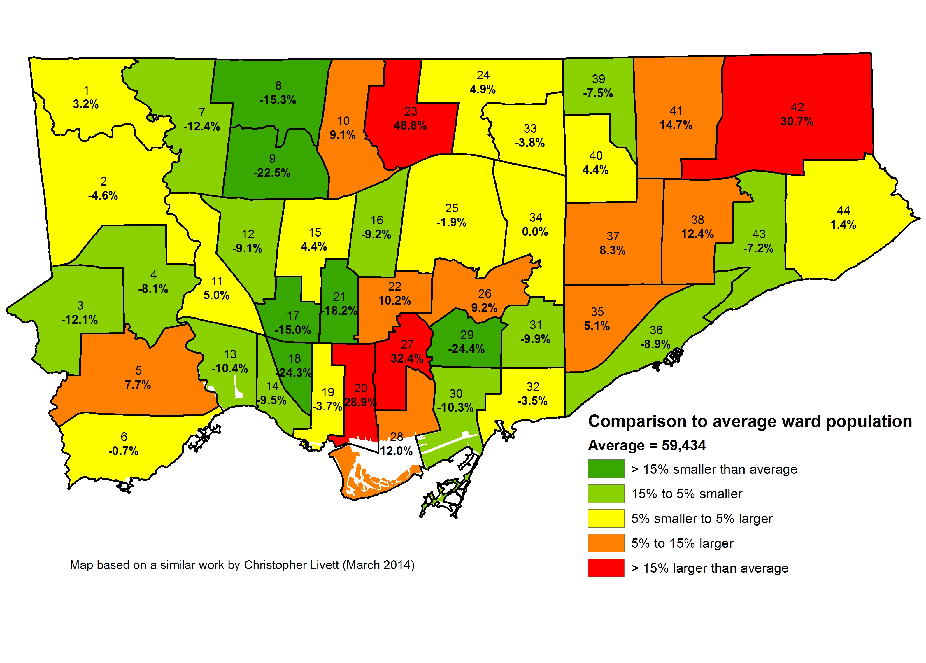 Map of how each ward is under-represented or over-represented in Toronto, map based on one previously created by Christopher Livett
The city’s review process, which you can find more about here, is being conducted by independent consultants, so far free of political influence. Though the first round of public consultations have already occurred, there will be further opportunity to participate in the development of ward boundary options. There has yet to be a decision as to how many councillors Toronto should have going forward, or what the boundaries will look like. The committee will report to city council in early-mid 2016 with their recommendations, giving plenty of time before the next election, which will be held in October, 2018.
Part of the problem does back to the 1995 election of the Progressive Conservatives under Mike Harris. One of the Harris government’s many acts that sought to reduce the size and scope of government was the Fewer Politicians Act of 1996, which reduced the number of Members of Provincial Parliament from 130 to 103 – the same number of Members of Parliament apportioned to Ontario starting with the 1997 federal election. The federal and provincial electoral district boundaries (often referred to as ridings or constituencies) became identical for the 1999 election, in which the Conservatives were handily re-elected. In April 1997, the government introduced the City of Toronto Act, known as Bill 103. That bill, of course, amalgamated the six constituent municipalities in Metropolitan Toronto to create what was known as “the Megacity.”
Despite widespread opposition and filibustering by the New Democrats, the bill passed that same month and came into force on January 1, 1998. In the November, 1997 election, there were 23 wards, those used by Metropolitan Toronto’s council and based on the old municipal boundaries (the former Borough of East York was a single ward) – two councillors were elected to each for a total of 56 councillors plus the mayor.
In the fall of 1998, a third councillor, Jane Pitfield, was elected to the East York ward. The by-election was held as East York was under-represented in the new amalgamated city. After the 1999 provincial election, in which the Harris Conservatives were returned to power, the Minister of Municipal Affairs, Tony Clement, introduced The Fewer Politicians Act of 1999. The 1999 legislation resulted in further municipal amalgamations – Ottawa, Hamilton, and Sudbury were merged with their suburbs and surrounding rural areas. It also amended the City of Toronto Act:
1)The urban area is divided into 44 wards, or such other number as may be prescribed by regulation, and the boundaries of the wards are as prescribed by regulation.
By provincial fiat, the new 44 wards were created for the 2000 municipal election. The 44 wards were created simply by splitting the federal/provincial electoral districts in two, as depicted below. While Etobicoke and Scarborough kept their distinctive boundaries (the Humber/East Humber River and Victoria Park Avenue), the lines between Toronto, York, East York, and North York disappeared.  The political map in 2000
Unfortunately, those municipal wards haven’t kept up with population changes. In 2003, the federal government re-drew the boundaries, as required by law, based upon population counts taken in the 2001 census. Most boundaries simply shifted to more-closely represent equal numbers of people, but Toronto only got one-half of a new riding – Scarborough-Pickering, which spanned the Rouge River and shared with that eastern suburban municipality. The new districts were established for the 2004 federal election and the 2007 provincial election, though the province opted to add one additional seat to northern Ontario. If Scarborough has ever been done by, it’s been underrepresented by at least one councillor since 2003.  The federal constituency boundaries were changed again after the federal redistribution process was completed in October, 2013. Toronto will have 25 seats in the new federal Parliament that will be elected later this year; it would be reasonable to assume that the province will again adopt similar boundaries.
The most striking change is downtown: the long-established constituencies such as Trinity-Spadina and Toronto Centre-Rosedale give way to three new districts: University-Rosedale, Spadina-Fort York, and Toronto Centre. Other new districts include Don Valley North and Scarborough-Rouge Park. These address the increase in population downtown and in North York; only York South-Weston retains the exact shape as it had in the 1990s.  Keeping with precedent set in 1999, there would be 50 city councillors if the City of Toronto chose divide the new 25 districts into two wards each. This would be the simplest solution, though I’ll keep an open mind. Perhaps it’s time to break down the boundaries separating Scarborough and Etobicoke with the rest of the city.
Predictably some commentators (like former conservative councillor and failed mayoral candidate Karen Stintz) will complain about “more politicians at the trough,” or some nonsense like that, maybe arguing that Toronto should only have a total of 25 councillors (as urged by the Toronto Taxpayers “Coalition.” But I do not envy the job that good city councillors have – it’s a lot of thankless council and committee work; effective councillors spend much of their time away from city hall at public meetings and constituency work, meeting with local residents about their problems and concerns. In wards with many new development proposals and construction (mostly downtown, midtown and in central North York), councillors and their staff can easily become overloaded.
Yes, city council meetings will probably be smoother with fewer voices, but it’s generally a handful of bad local politicians – Ford, Mammoliti, and Karygiannis – ironically all right-wingers, who delight in wasting everyone’s time with their bickering and frivolous motions. Reducing the number of councillors is not the solution. I look forward to participating further in the Toronto Ward Boundary Review, and if this interests you, I recommend being involved in the next round of consultations.

Leave a comment