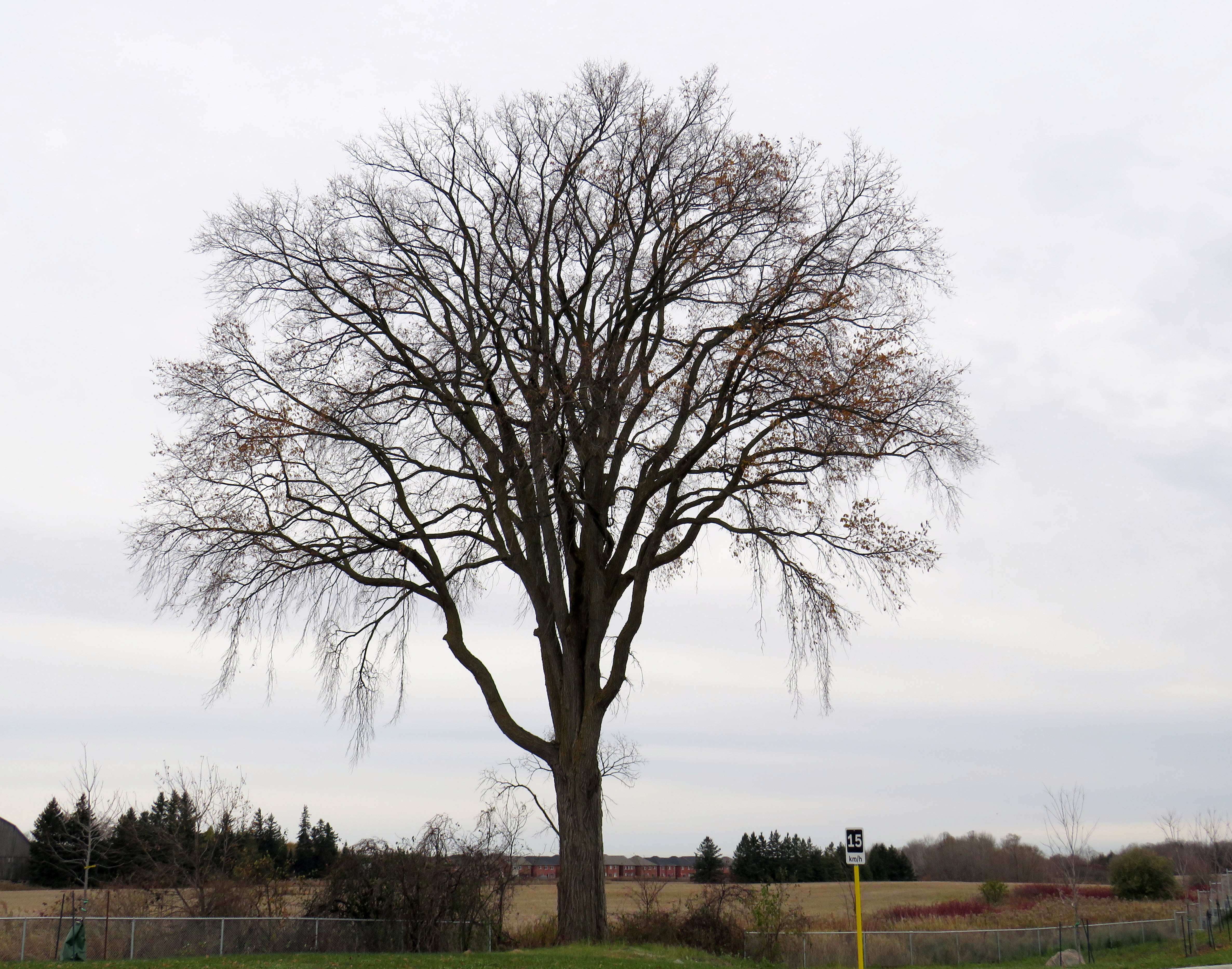
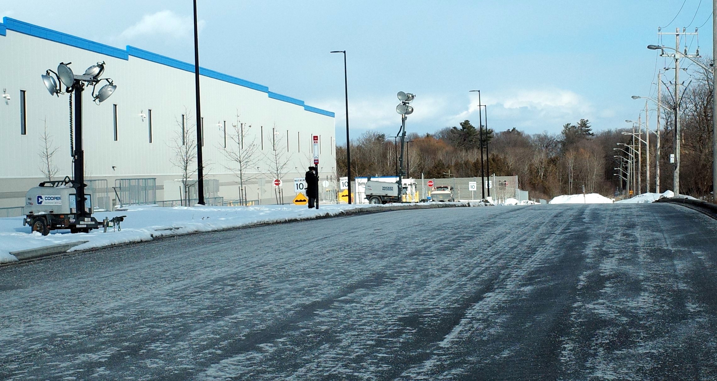
On Monday, October 30, the new Old Elm GO Station opened in the town of Whitchurch-Stouffville, northeast of Toronto. Located two kilometres away from Stouffville’s small downtown core, Old Elm is focused on park-and-ride passengers arriving from nearby communities such as Goodwood, Uxbridge, Port Perry, Beaverton, and from within Stouffville itself.
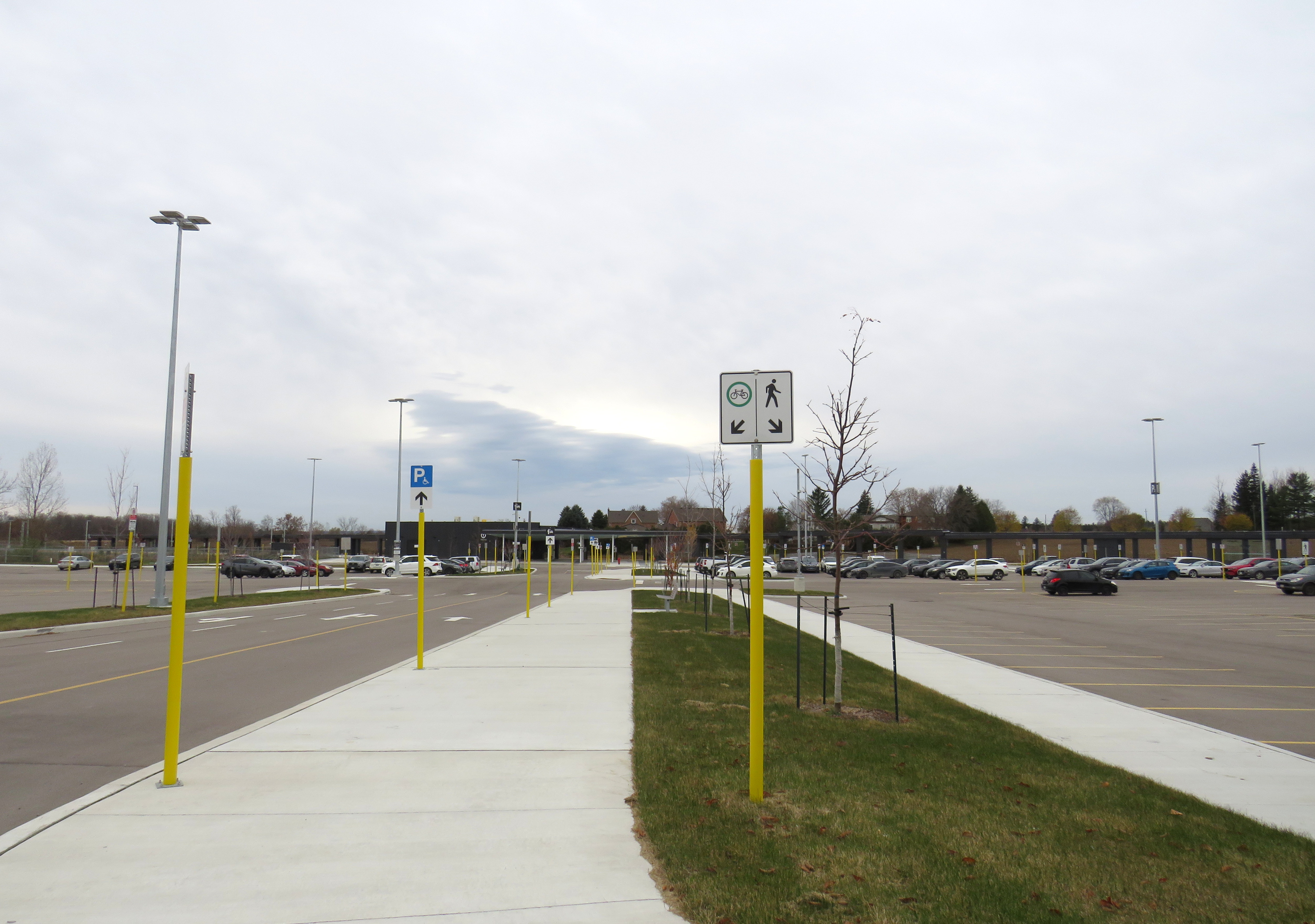
The new station is relatively simple, with a covered platform, a bus loop with several bays directly adjacent to the single platform, heated shelters, and a 673-spot parking lot. As a relatively quiet station with limited train service, there is no indoor waiting room or ticket office.
The bus loop is directly adjacent to the train platform
Though train service is limited to weekday rush hours and a few evening and weekend departures, there is regular GO Transit bus service connecting Uxbridge and Goodwood to Old Elm Station, and onwards to midday and weekend train connections at Mount Joy or continuing to Toronto Union Station. There are no York Region Transit connections at Old Elm.
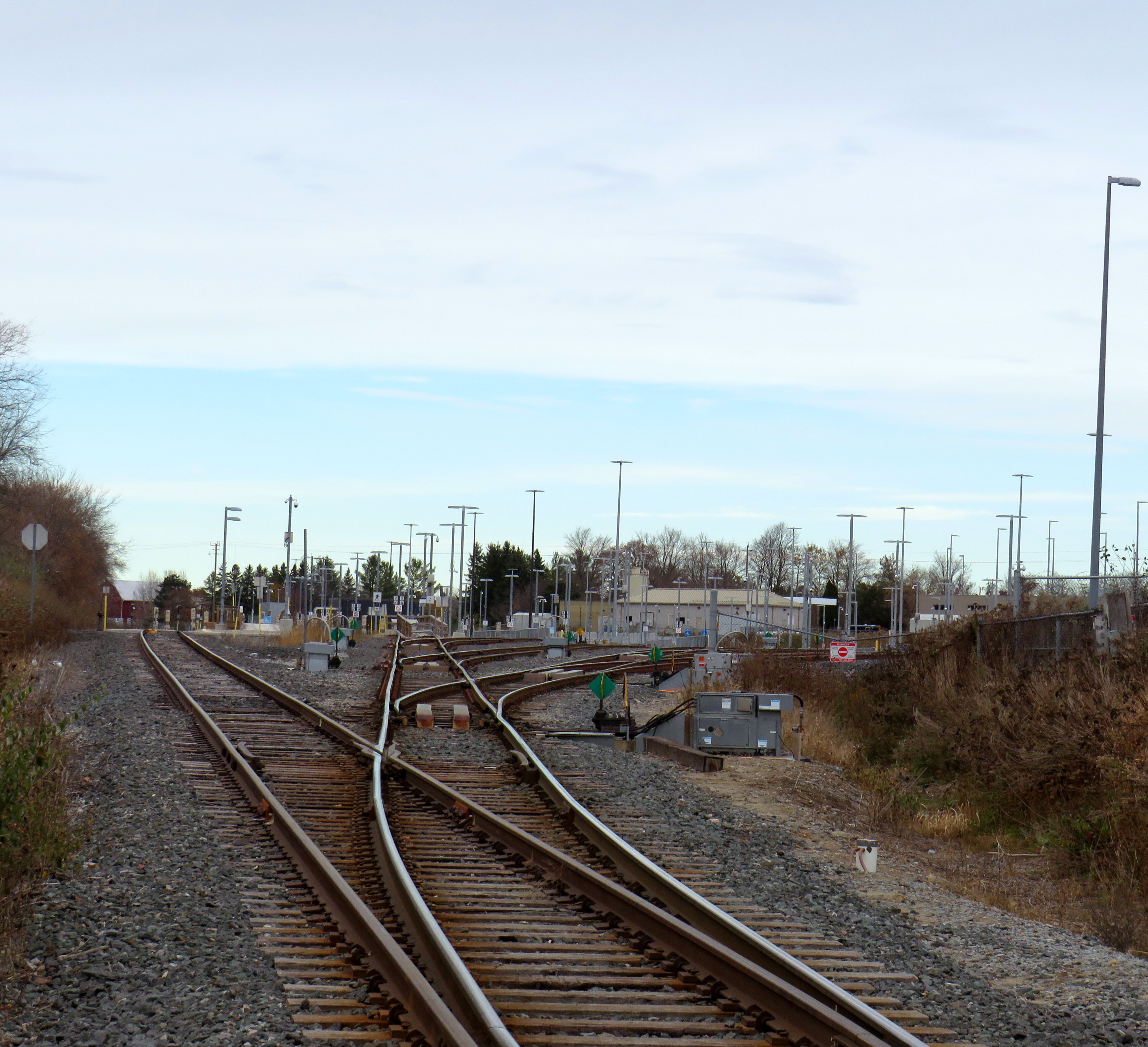
The Lincolnville layover yard, which was also the Lincolnville/Old Elm station location until October 2023
Previously, Old Elm Station was located a few hundred metres away, northeast of the Tenth Line/Bethesda Side Road intersection at the Lincolnville layover yard, where Stouffville Line trains continue to be stored overnight and weekends. That station, originally named Lincolnville for a nearby hamlet, was opened in 2008 to accommodate service expansion and relieve the small station at Stouffville, which had no room for a bus loop or additional parking. Since Lincolnville was a yard terminus, passengers had to walk across tracks to reach the next departing train, and each departing and arriving train had to crawl through the yard before reaching the mainline. (As Georgetown GO Station is also within a layover yard, trains passing through on their way to and from Kitchener must also crawl through. A new layover yard near Heritage Road in Brampton will allow for a rebuilt Georgetown Station with faster arrivals and departures.)
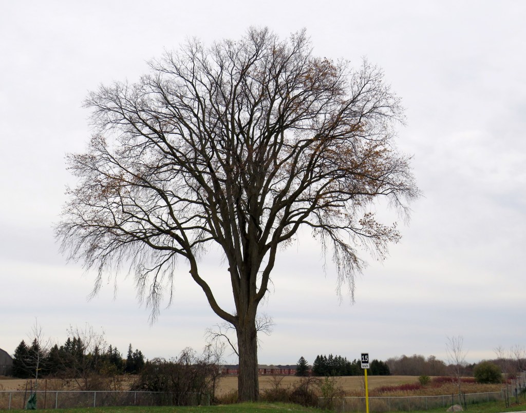
Lincolnville Station was confusingly renamed Old Elm in 2021, even though that new name referred to a tree on the new station site that didn’t open for two more years. Had the new name taken effect with the location change, it would have made more sense.
The new station site, located outside of the Lincolnville yard, allows for smoother and faster arrivals and departures, shaving several minutes off the trip for passengers to and from Lincolnville.
The station’s namesake, an old elm tree on the south end of the GO Transit property
Though Lincolnville/Old Elm is located in the Greenbelt, and the station is unable to support transit-oriented urban development, there was a need for the layover yard. Adding a small, auto-focused station was quite sensible. This is no Garage Mahal.
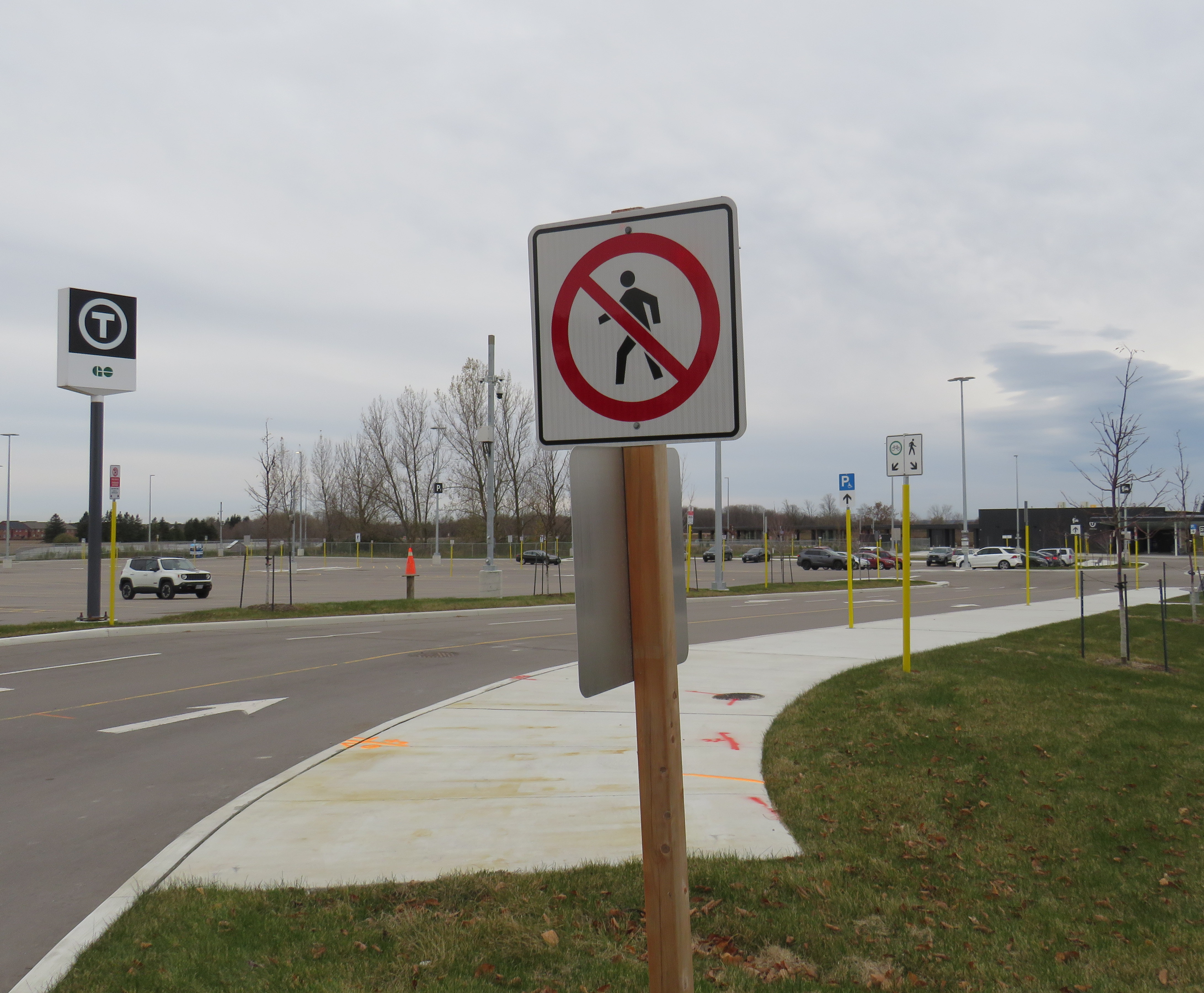
The one unfortunate feature is the complete lack of active transportation access beyond the station property. Though Metrolinx built a wide concrete walkway from Tenth Line to the station platforms, there are no sidewalks, no crosswalks, and no pedestrian signals at either the main entrance or the bus loop entrance, which are both signalized intersections. Instead, there are “no pedestrians” signs facing all directions.
“No pedestrians” sign placed in front of the new concrete pathway into Old Elm Station
Once on Metrolinx property, though, there is a wide pathway, presumably for cyclists and pedestrians. Interestingly, the sign below shows that cyclists should keep to the left, on the wide pathway, while pedestrians are directed into the grass to the right.
Beyond the “no pedestrians” sign at the intersection, another sign instructs cyclists to keep to the left and pedestrians to the right – into the grass
I doubt Metrolinx intended for the hostile intersections to forbid any pedestrian activity. I note too that despite the rural locale, there are several neighbouring homes and businesses along Tenth Line and Bethesda Side Road. The nearest subdivision is less than a 15-minute walk away, a healthy stroll’s distance. A new residential development, Elm Villa, is planned for the site immediately to the south of the bus loop. Tenth Line is maintained by the Town of Whitchurch-Stouffville, so it is likely they are responsible for the oversight. Still, it is not a great look.
Earlier this year, I had the opportunity to travel to the US Midwest. My spouse had a business meeting to attend in Chicago, so we made the most of our trip. I spent time in a few interesting cities, including Milwaukee, Madison, and Minneapolis-St. Paul.
Having been to Chicago many times now, I sought out new and interesting places to visit off the tourists’ beaten paths. One of these places was The 606/Bloomingdale Trail, located a few miles northwest of Chicago’s downtown Loop.
Though Chicago is famous for its elevated railway transit system (known as the “L”) it is also crisscrossed by hundreds of miles of mainline and spur railways, most of which is grade-separated from the local street network. These rail corridors were built by over a dozen railroad companies, whose vast networks converged on Chicago, bringing in, among many other things, grain, cattle, metals, and sending out cereals, meat products, industrial goods, and merchandise purchased from Sears, Roebuck and Montgomery Ward. Chicago’s dominance as a rail centre allowed it to grow into America’s second-largest city (it is now the third-largest).
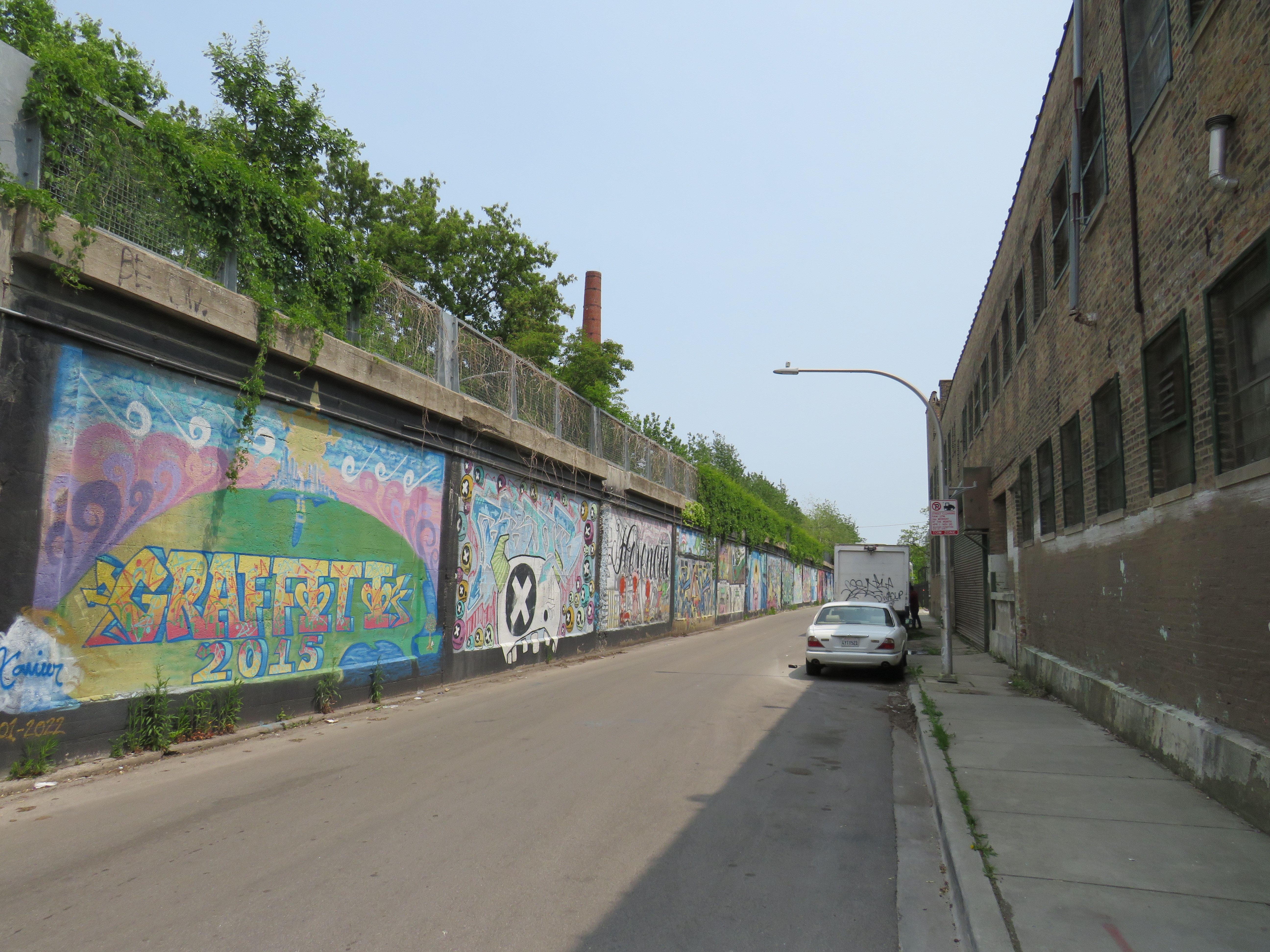
There are still many railways and yards throughout the city, along with an expansive commuter rail network, but many of the industrial spurs and branch lines became redundant with the decline of heavy industry and the shift to trucking. The Bloomingdale line, once a busy freight corridor owned by the Chicago, Milwaukee, St. Paul and Pacific Railroad (known as the Milwaukee Road, later part of Canadian Pacific’s network) was just one of these routes.
Some local industries still stand on Bloomingdale Avenue next to the abandoned rail corridor
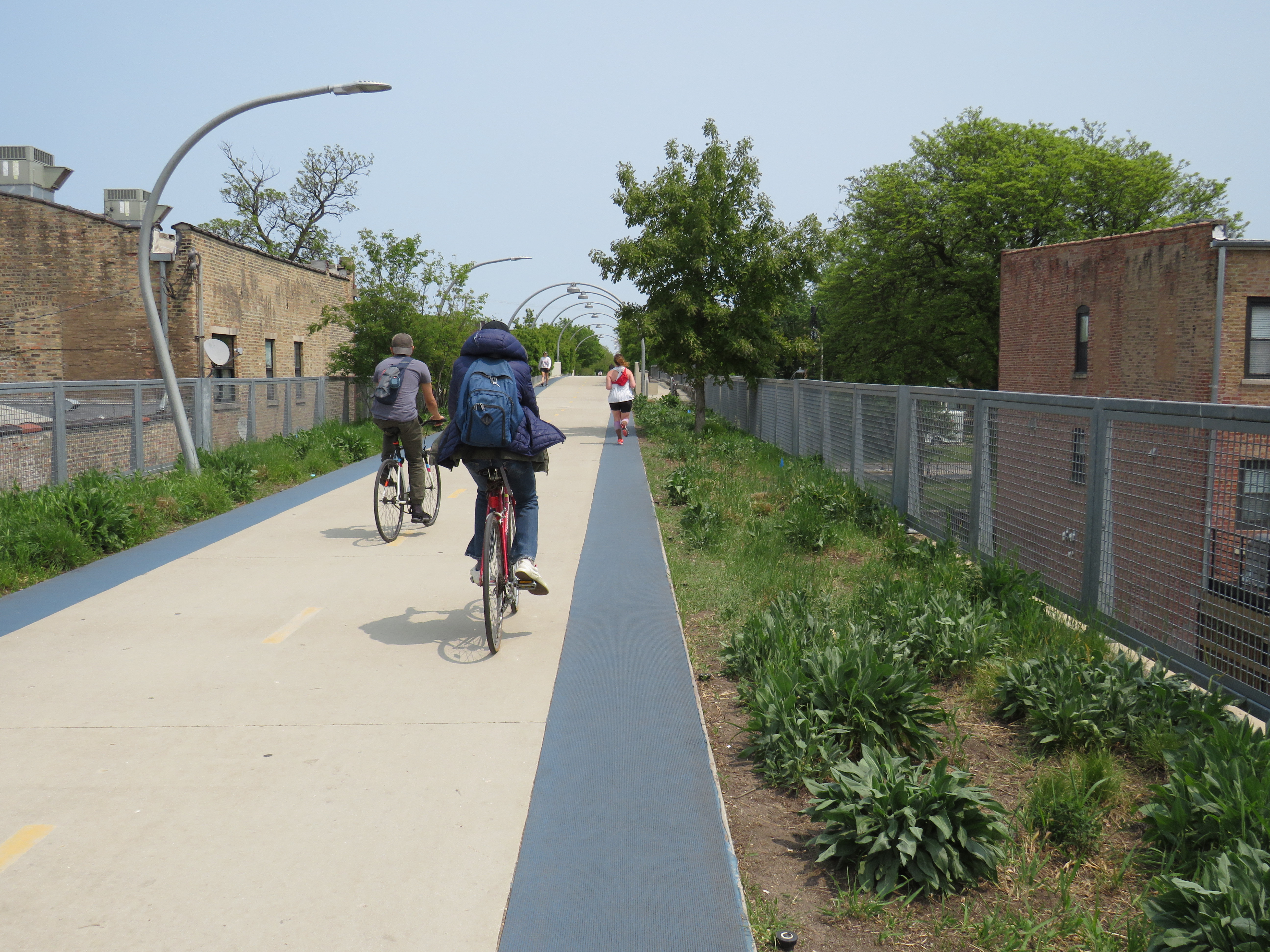
The trail, built as a partnership between the local Friends of Bloomingdale Trail group, the federal non-profit Trust for Public Land, and the City of Chicago, opened in June 2013. Ten years later, the corridor is kept in excellent shape, and still looks fresh. The 4.3 kilometre (2.7 mile) trail is the longest elevated greenway in North America, longer even than New York’s High Line.
On the day I visited, I rode the entire length of the trail in one direction on a Divvy bikeshare bike and walked most of the distance on the way back.
The Bloomingdale Trail crosses Central Park Avenue, near the western terminus of the public corridor
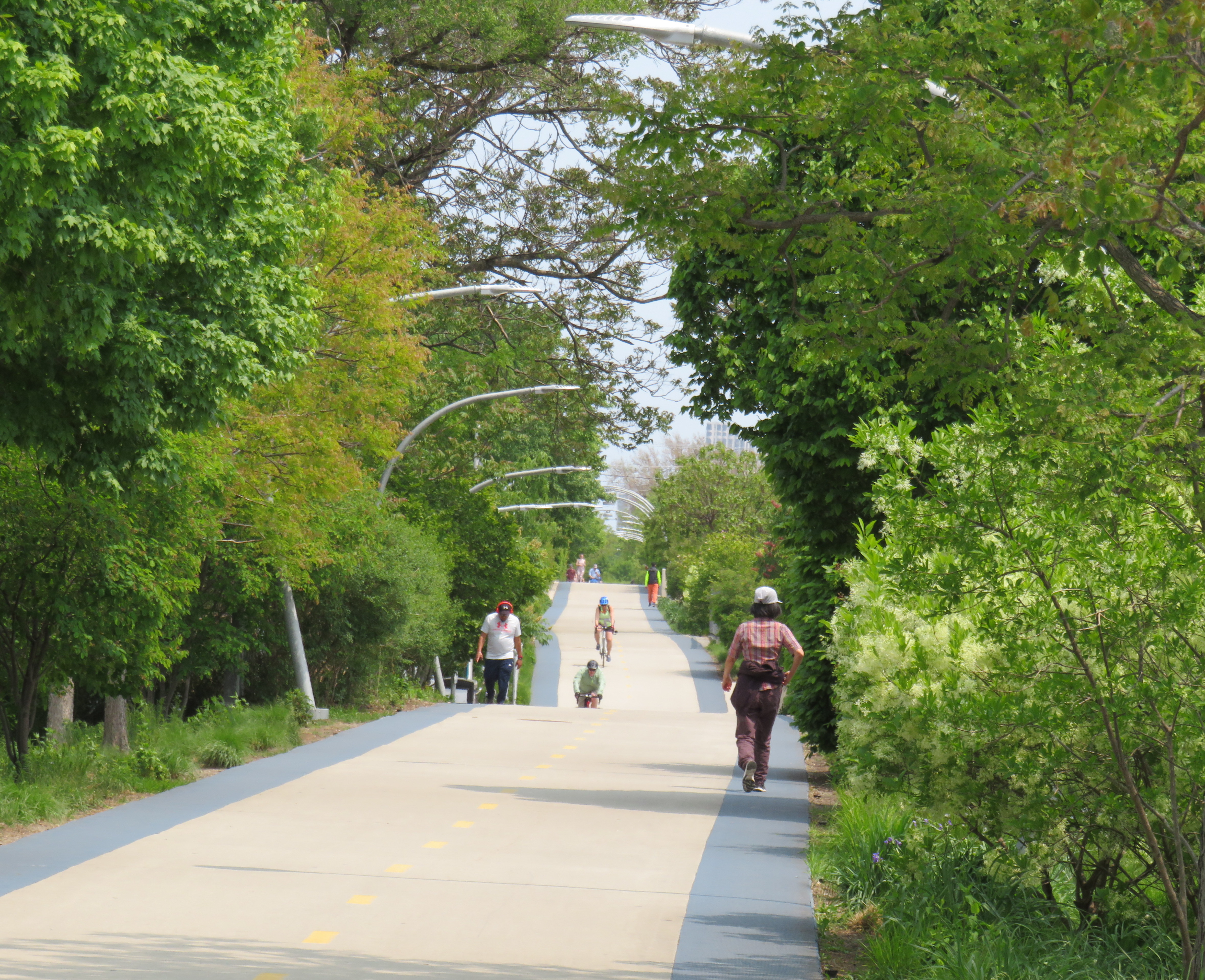
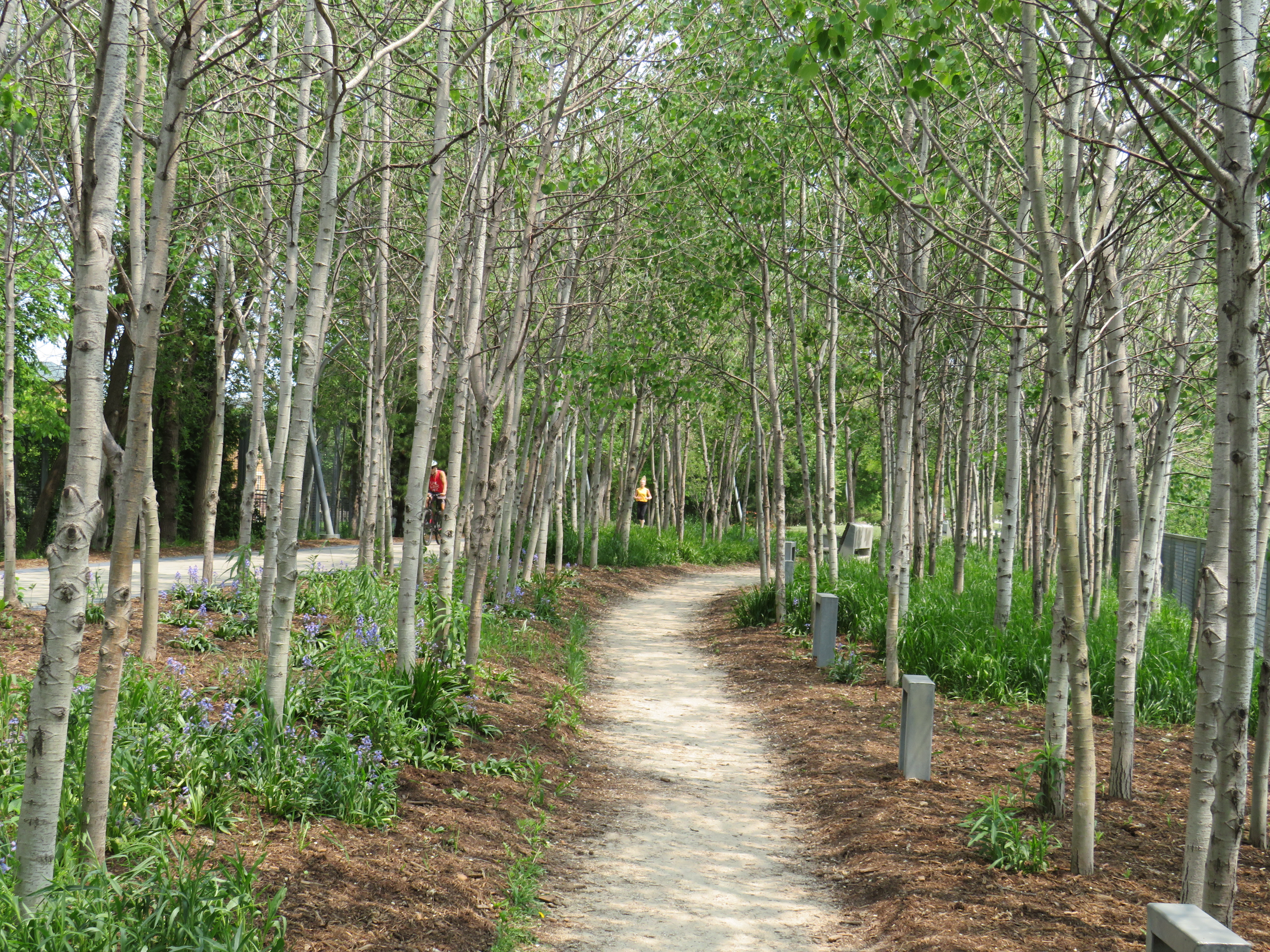
Unlike the High Line, the Bloomingdale Trail is open to cyclists, and is much less programmed, catering more to the surrounding neighbourhoods than tourists. The pathway is quite wide, making it quite suited to multiple uses. On each side of the pathway is a rubberized track, providing an incentive to walkers and runners to keep to the right. The trees are well maintained, providing plenty of shade. Benches and working water fountains are found throughout.
Rubberized edges on both sides of the pathwayOne of many water fountains along the routeA stand of poplars and a walking path at a wider part of the elevated right-of-way
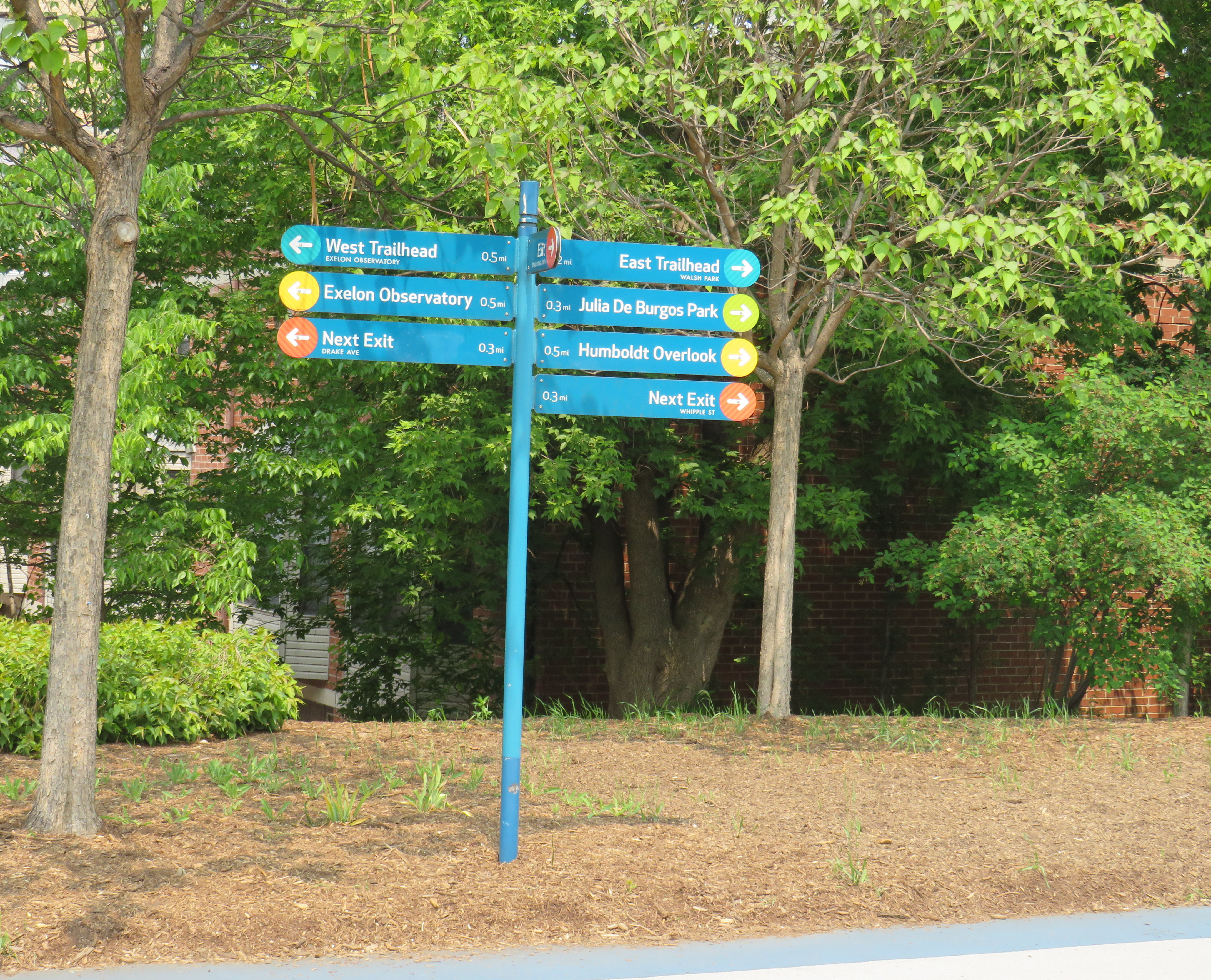
As the path follows an elevated rail corridor, not every intersecting street has an entrance to The 606/Bloomingdale Trail. However, fully accessible ramps are offered every 3-4 blocks, with stairwells installed at other locations. Wayfinding signage is good too, indicating the distances to local highlights and the nearest exits.
Wayfinding sign, indicating trail highlights, connecting parks, and the next exits
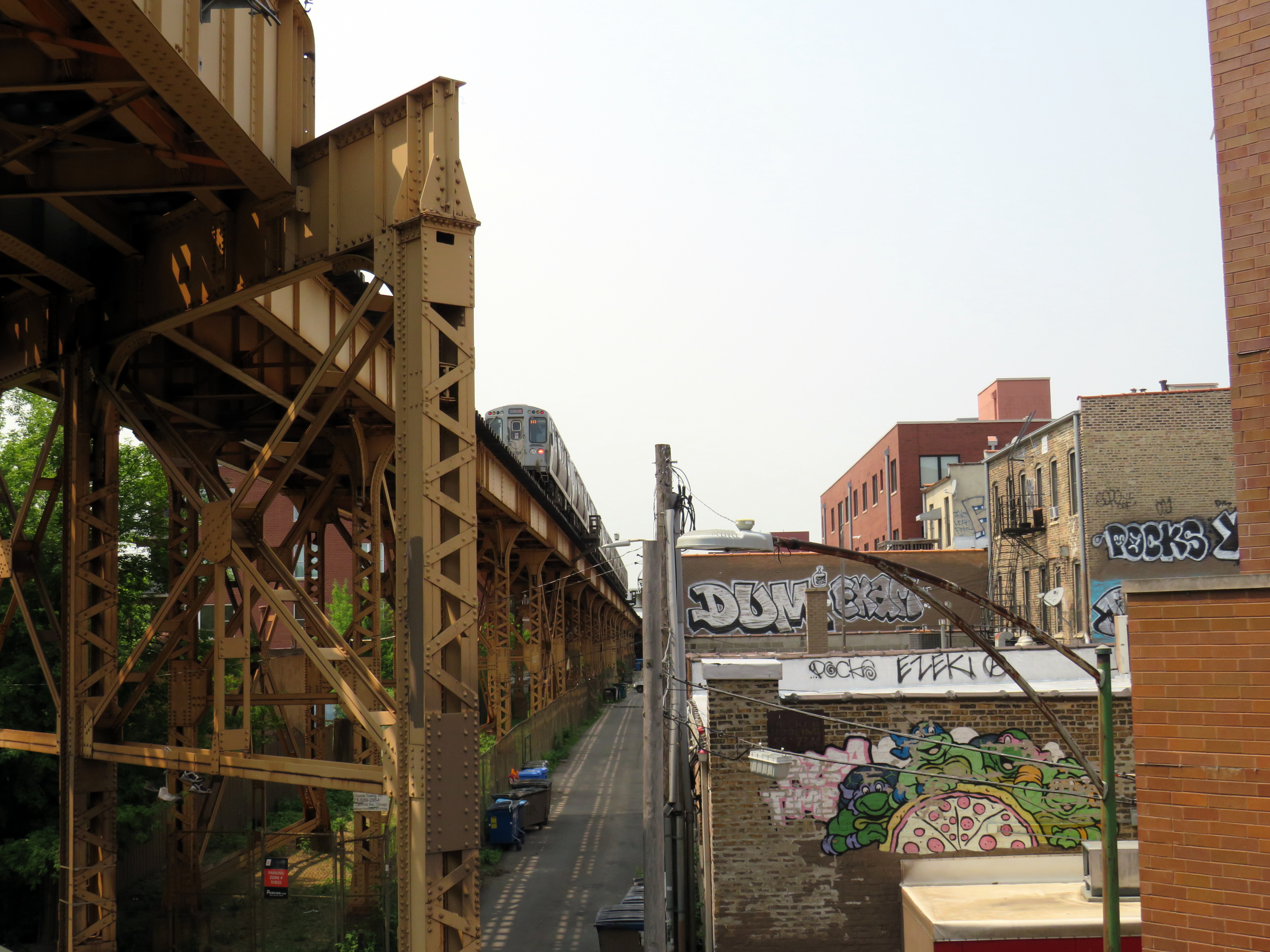
One thing I really appreciated about the Bloomingdale Trail are the unique vantage points. Milwaukee Avenue offers a lovely view towards Wicker Park and the Loop, while other parts of the trail pass by neighbourhood parks, backyards, and old warehouses.
Looking southeast down Milwaukee Avenue towards Wicker ParkView looking northwest to the Blue Line L and the alley behind Milwaukee Avenue
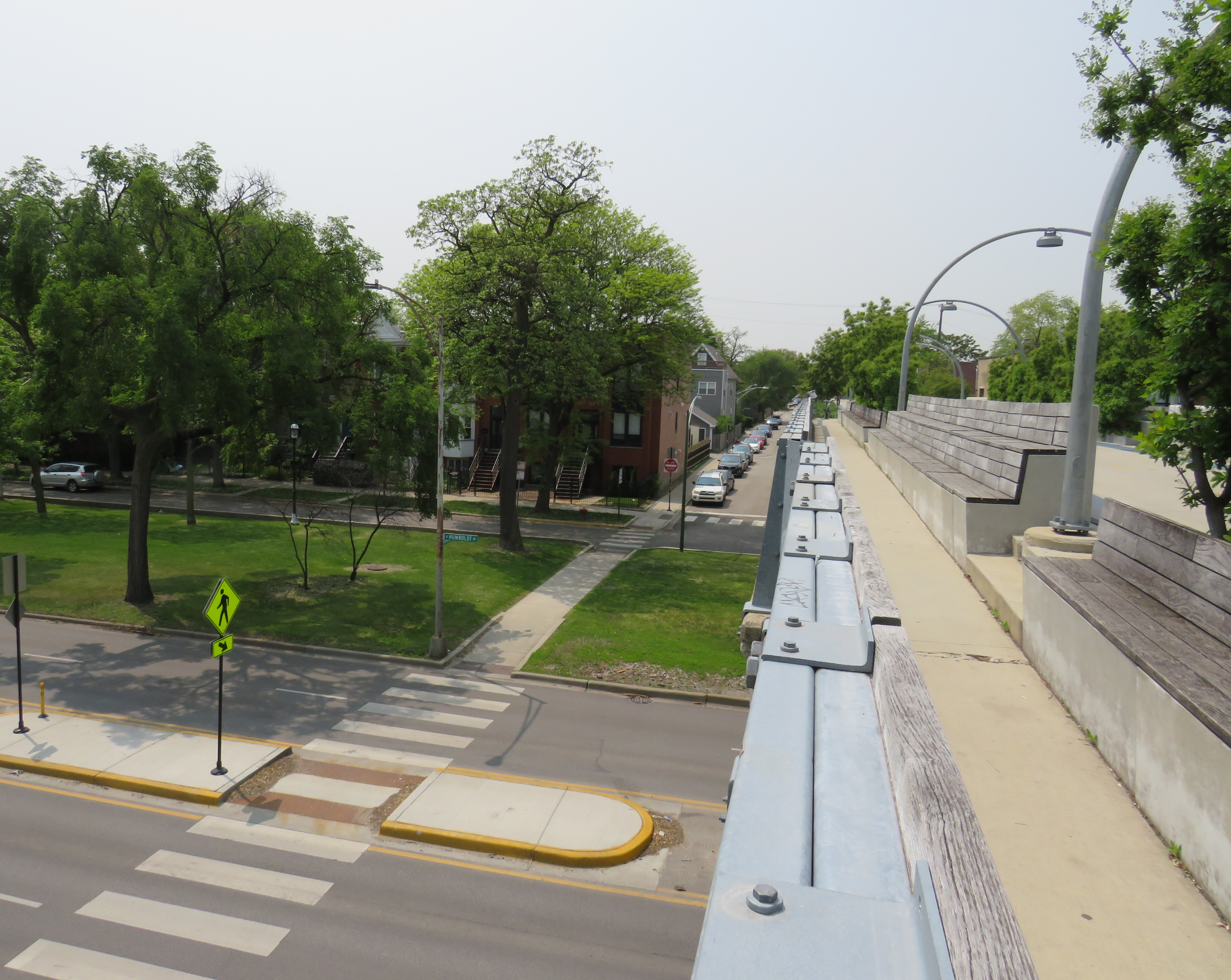
At several intersecting streets, benches have been strategically placed to provide gathering places called “overlooks.” Where it crosses Humboldt Boulevard, part of the parkway ring surrounding central Chicago, over hundred people could sit and watch the traffic below. at once
Lookout to Humboldt Boulevard
Though the circumstances that allowed for the great elevated parks like Chicago’s 606 or New York’s High Line are unique to their locations, there are lessons that can be learned for other projects, as in Toronto.
The presence of shade helps to make Chicago’s Bloomingdale Trail a success, as does the very wide pathway that accommodates all active transport users. (On a pleasant Thursday afternoon, the trail was about as busy as the Lower Don Trail here in Toronto, but the wide spaces reduced conflict between walkers, runners, and cyclists.) There need not be a lot of special features to animate the space, though thoughtful places to sit, hydrate, and connect to intersecting public spaces and streets are important.
There are opportunities for Toronto to expand and improve upon its off-street greenways like the West Toronto Rail Path, the ravine trails, the Greenway, and possibilities for the Green Line and East Toronto; this is just one example of the concept done well.
Curb lanes closed for condominium construction have defeated the purpose of Jarvis Street’s fifth reversible lane
Over a century ago, Jarvis Street was Toronto’s most fashionable address, and home to prominent families including the Masseys, who made their wealth from the farm equipment industry, and whose names live on through Massey Hall, Hart House, the Fred Victor Mission, and Massey College. The wide boulevards allowed for lush street trees to flourish, and without streetcars, there was no need for a wide roadway, despite the generous right-of-way.
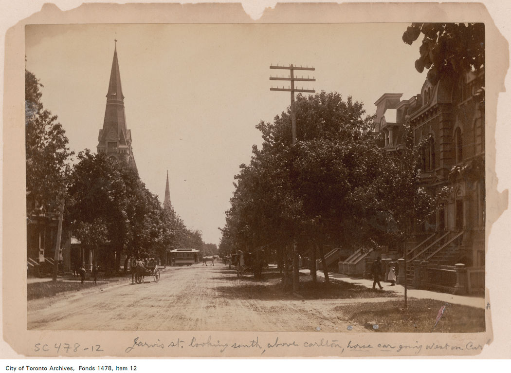
Jarvis Street looking south towards Carlton Street in the 1880s. City of Toronto Archives: Fonds 1478, Item 12.
By the 1920s, though, Jarvis was no longer fashionable, with Forest Hill, North Rosedale, and Moore Park taking its place. Many of the old mansions fell into disrepair or were converted into apartments or businesses. The street became lined with low-rise apartment buildings, budget hotels, and missions to the poor and unhoused. After the Second World War, the city government decided to extend Mount Pleasant Road south of St. Clair Avenue to Bloor and Jarvis Streets and widen Jarvis Street to accommodate the increased traffic. Along with building the Dundas Street East extension, widening Dufferin Street, and pushing through Eastern Avenue, the City of Toronto was bending to the whims of the automobile, several years before the creation of Metropolitan Toronto in 1954.
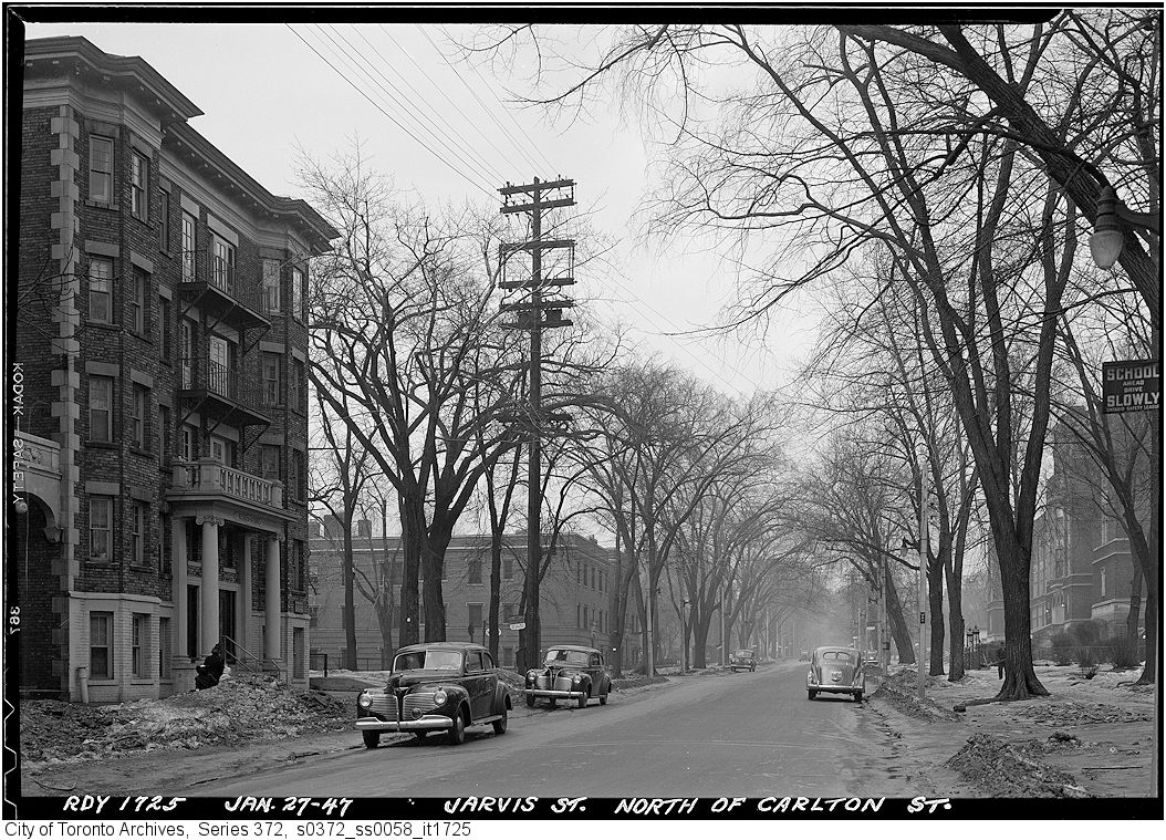
Jarvis Street looking north from Carlton Street, January 1947, just before the street trees were removed and the street widened. City of Toronto Archives, Series 372, Item 1725.
By the 1960s, Jarvis Street became the preferred address of federal institutions such as the Moss Park Armoury, the regional Unemployment Insurance offices at Dundas Street, and the brutalist Ontario headquarters for the RCMP. The provincial government expanded the old Juvenile Court with a new modernist building, and Simpsons-Sears, the predecessor of Sears Canada, built a new imposing office building at 222 Jarvis, adjacent to the Simpsons warehouse on Mutual Street.
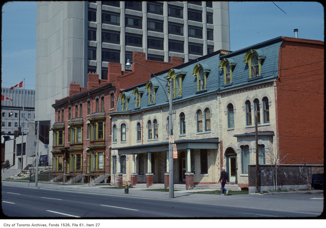
Victorian rowhouses stand next to the brutalist RCMP building on Jarvis Street, north of Shuter Street in 1979. The RCMP building later became the home of the Grand Hotel, which installed a glass veneer over the imposing west façade. The Unemployment Insurance office, at the corner of Dundas Street appears in the far left. Both the RCMP/Grand Hotel and the UIC (later Hilton Garden Inn) building were recently demolished, but the rowhouses still stand. Photo by Harvey R. Naylor. City of Toronto Archives, Fonds 1526, File 61, Item 27.
Jarvis Street was also the home of several of the CBC’s scattered radio and television studio spaces until they were consolidated at the CBC Broadcasting Centre on Front Street, and it was also the location of the first Four Seasons Hotel, when it started out as a chic motor hotel.
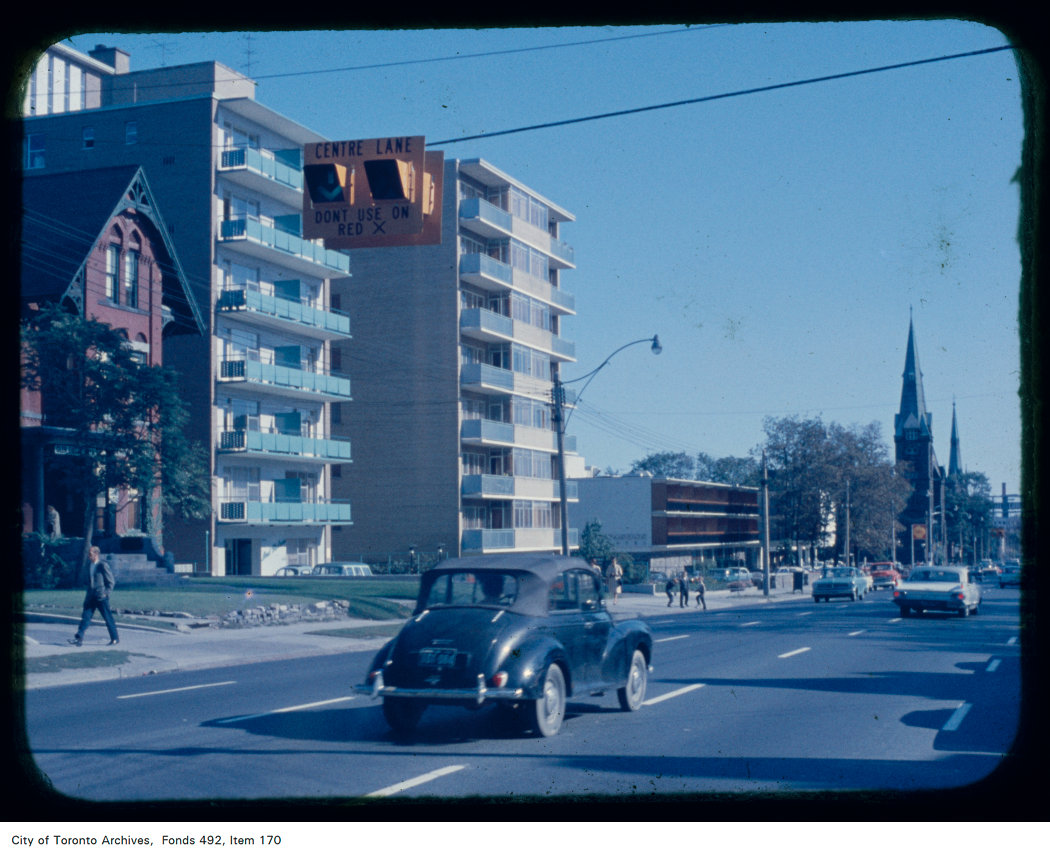
Jarvis Street looking south from north of Carlton Street; the Four Seasons Motor Hotel at 415 Jarvis Street and St. Andrew’s Lutheran Church are visible in the background. Note the centre lane indicator above. Creator: Skinner, Dorothea Skinner. City of Toronto Archives Fonds 492, Item 170.
By the early 1960s, Jarvis Street was reconfigured further to include a new reversible centre lane between Queen Street and Mount Pleasant Road at Charles Street. Then, as now, the centre lane was designated for southbound traffic, except during weekday afternoon rush hour, when the flow is reversed. Parking is prohibited at all times on the east side of the street, while on the west side, street parking is permitted except during the morning and afternoon peak periods. This, at least in theory, allows for two lanes of unobstructed traffic in both directions at all times, and in the rush hours, three lanes of peak-direction traffic. This, of course, depended on strict enforcement of parking and stopping prohibitions, and the lack of construction or other obstructions.
As Jarvis Street rebounded and new residential development and commercial development began to line the street between the mid-1980s and the present day, the five-lane traffic arterial layout became less suitable. In 2009, City of Toronto staff recommended, with extensive public input, that it was desirable to remove the reversible centre lane, narrow the roadway, and widen the sidewalk on the east side of the street to improve the public realm and address the needs of the thousands of new residents who were moving into the east end of Downtown Toronto. The additional space would have allowed for tree planters and wayfinding signage that would highlight the street’s history. Studies conducted by city staff found that there was no need for the fifth lane to provide adequate traffic movement along the street.
Cyclists, however, were unhappy that the road redesign did not include cycling lanes and they were able to convince council to alter its plans. As a result, in 2010, the road was not reconstructed, but the reversible lane was removed, with new painted cycle lanes on both sides of the street.
When Toronto elected Rob Ford as mayor that October, he promised an end to “the war on the car,” even inviting now-disgraced hockey commentator Don Cherry to give the inaugural speech, which turned out to be a controversial rant against “pinko cyclists” and “left wing kooks.” In 2011, with the support of suburban councillors, Rob Ford reversed the decision to install bike lanes on Jarvis Street (along with Pharmacy Avenue and Birchmount Road in Scarborough), and the reversible lane was re-installed.
Ironically, the demand by cyclists for bike lanes made it easy to restore the auto-oriented configuration, while widened sidewalks would have been much more difficult to remove.
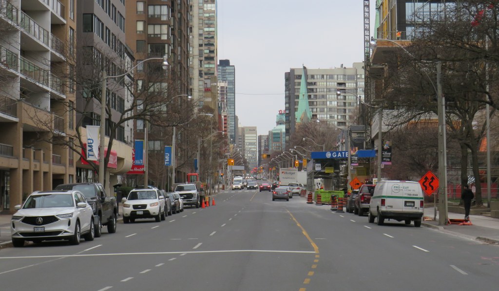
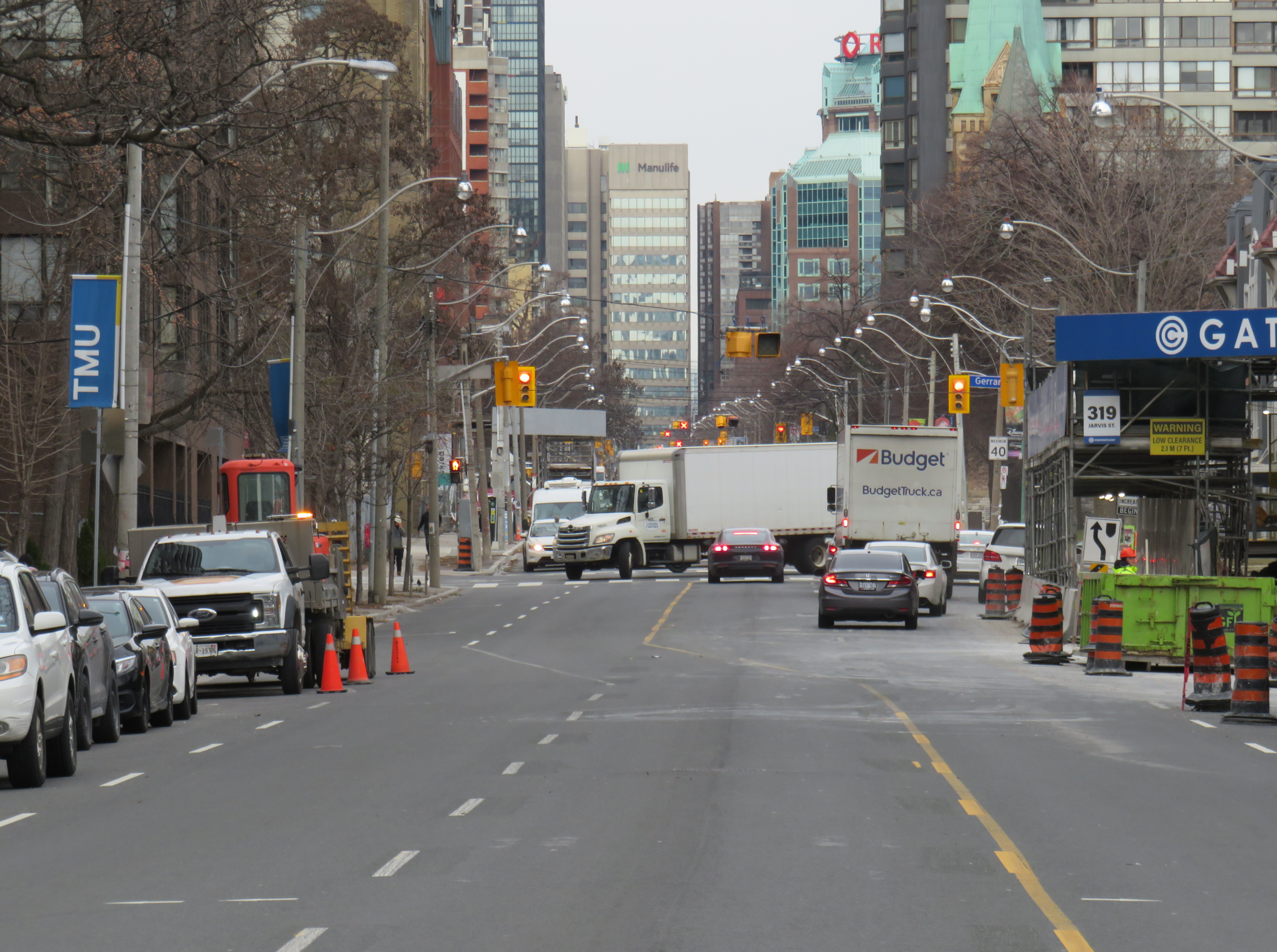
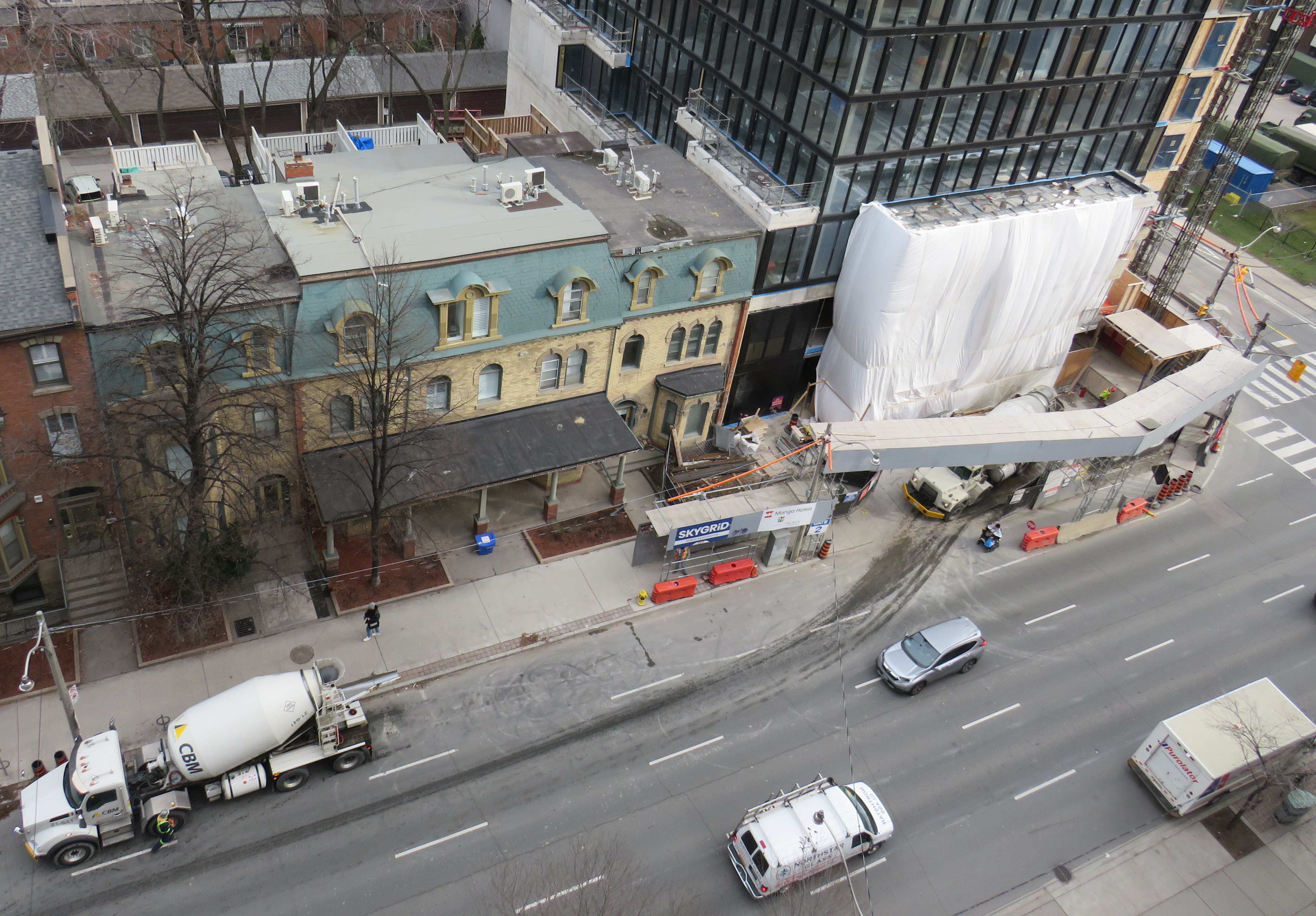
Between Dundas and Gerrard Street, the lanes shift to accommodate a lane closure for a new condominium tower on the east side of Jarvis Street.
With much needed watermain and road reconstruction in the last few years, the traffic advantage provided by the reversible lane was negated because of the construction barriers. Several condominium towers being constructed along the street, at Carlton, Gerrard, and Shuter Streets, have further affected the ability of that fifth lane to move motorists quickly, effectively, or safely. Between Dundas and Gerrard Streets, the lanes temporarily shift for a long-term lane closure on the east side, just south of Gerrard. This lane shift adds additional confusion to an already confusing road layout.
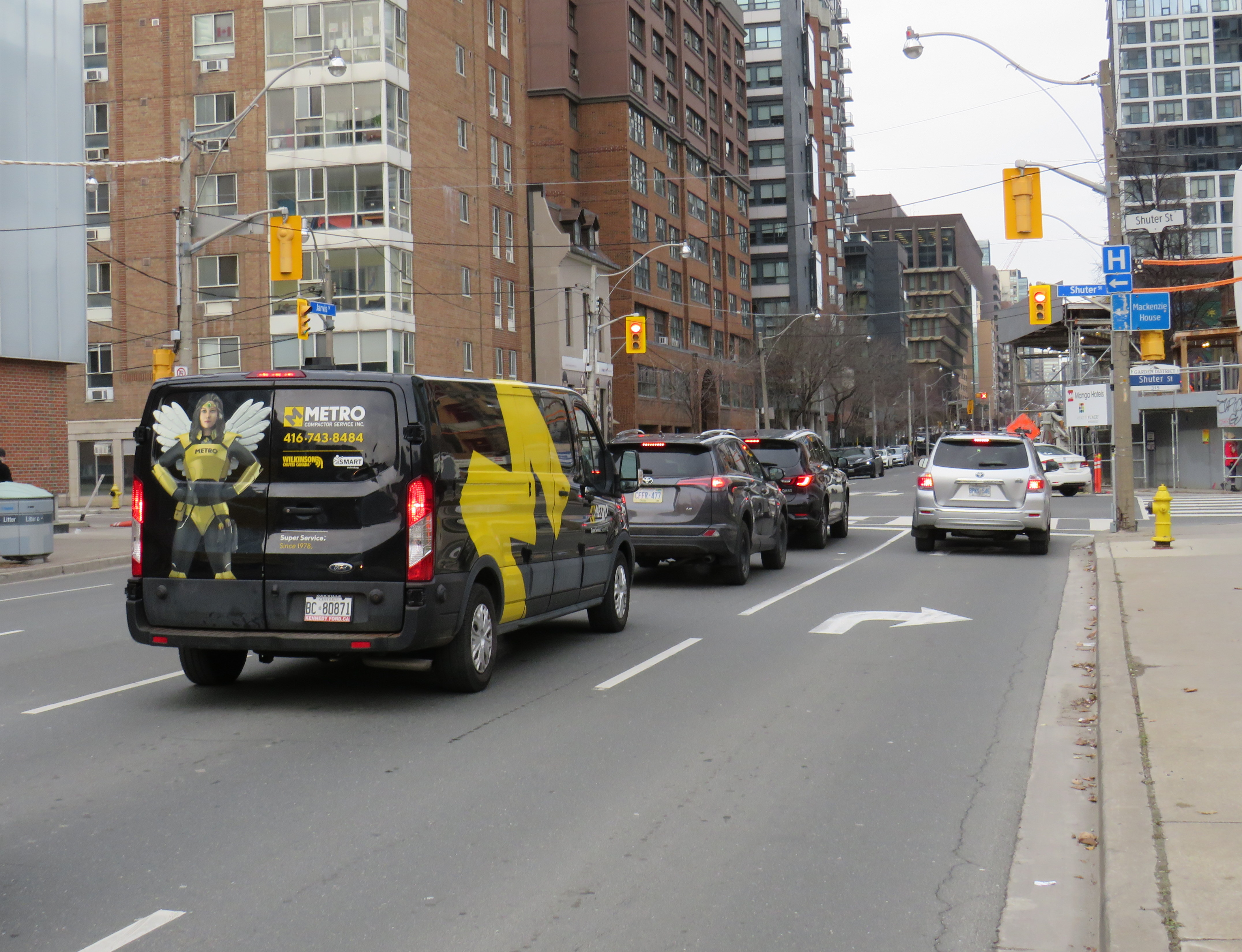
Looking north to Shuter Street, with the curb lane temporarily marked for right turns only.
At Shuter Street, the construction of the Hyatt Place hotel and condominium apartment development has seen the northbound curb lane closed for several years. Approaching Shuter, the curb lane is marked as a right-turn lane, but it is used as an illegal bypass of traffic waiting at the light or turning left onto Shuter towards St. Michael’s Hospital and the Eaton Centre. This, combined with the hidden sightlines caused by the construction hoarding on the northeast corner, makes it especially dangerous for southbound motorists as well as pedestrians and cyclists crossing at this point. Beyond the construction hoarding, the right lane is used for construction crew parking, as well as staging for vehicles such as cement trucks.
Looking down towards the Hyatt Place development, showing the obstructed northbound curb lane, as well as a grey SUV crossing into the centre lane, which was reserved for opposing traffic when this photo was taken.
The long-term closure of lanes on Jarvis Street should make it clear to city officials that the outdated and unsafe middle lane is of no practical use, and it finally has got to go.
At Jarvis and Shuter Streets, the northbound right turn lane is used by impatient motorists, including a City of Toronto garbage truck, a taxi cab, and the driver of a speeding Lincoln Navigator.
Collisions are common on Jarvis Street because of the reversible centre lane — which exists nowhere else in Toronto, and in only a few places elsewhere in Canada — because of driver confusion, impatience, negligence and incompetence. As Jarvis Street becomes home to thousands of more residents in the next few years, is beyond time that the street becomes safer and more attractive to live, work, and enjoy life on.
An abandoned railway signal towers over Philadelphia’s Rail Park
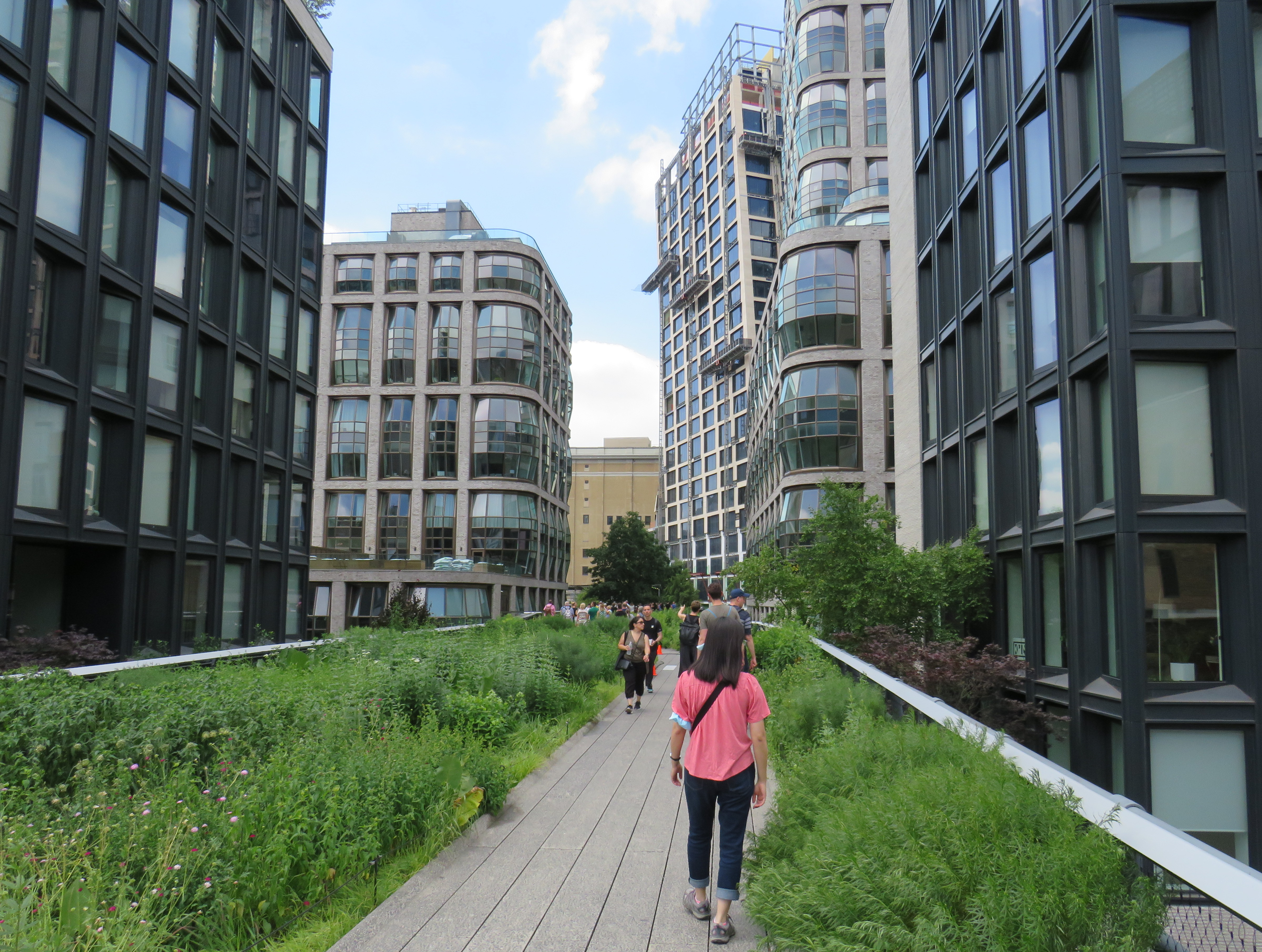
On a road trip early this summer, my spouse and I paid a visit to New York and Philadelphia. In New York, we walked the famous High Line, which revitalized an abandoned elevated freight railway corridor, transforming it into a popular grade-separated walking path on Manhattan’s Lower East Side.
New York’s High Line
While in Philadelphia, I made a point of visiting another abandoned rail viaduct — Rail Park. It’s as ambitious as New York’s famed public space, but — for now — it is much less known.
The viaducts, cuts, and tunnels that will make up Philadelphia Rail Park trace their origin to the golden age of railroading. The Philadelphia and Reading Railroad, which connected Philadelphia with its northern and western suburbs, industrial towns to the northwest, and the lucrative anthracite coal fields of northeast Pennsylvania. For many years, the Reading Railroad, as it was known, was one of the United States’ most profitable companies. In 1893, the railway opened its Philadelphia Terminal, which became famous for the public market that was established below the station platforms. To this day, the Reading Terminal Market remains a vital city landmark. In the 1930s, most of the commuter services were electrified.
The 1893 Reading Terminal headhouse, now the entrance to the Pennsylvania Convention Center
By the 1970s, both the Reading and PRR were bankrupt. PRR merged with its New York-Chicago rival New York Central in 1968, before it too went into insolvency. Conrail took over many failing railways in the US Northeast and Midwest, consolidating operations, abandoning or transferring redundant track, and transferring most remaining commuter train operations (which were not assumed by Amtrak) to regional and state transit authorities.
In the mid-1980s, the Southeast Pennsylvania Transit Authority (SEPTA), which assumed control of the regional rail services formerly operated by the PRR and the Reading undertook an ambitious project to unite the separate regional rail systems. A new four-track tunnel was constructed east from PRR’s Suburban Station, and a new station — Market East — built to replace the old Reading Terminal. For the first time, trains could run through central Philadelphia, providing improved regional rail services.
Though the historic Reading Terminal headhouse and the famous market were preserved, the station platforms were removed to make way for a new convention centre. For years, the abandoned viaducts and tunnels leading into Reading Terminal sat unused. At least they did, until June 2018.
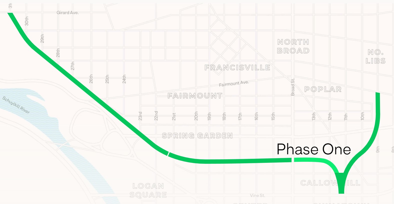
Entrance to the first phase of Rail Park, at Noble and 13th Streets
In 2018, a short, initial phase of Rail Park opened to the public. Spanning just two blocks, from Noble and 13th Streets to Callowhill and 11th Streets, it is still a remarkable public space. Like New York’s High Line, the short section of viaduct provides new viewpoints over gritty city streets, with temporary and permanent public art installations along the route.
A map of the proposed extensions of Rail Park, with the opened first phase marked. Interactive map here. Looking north up 13th Street, towards the gentrifying Spring Garden neighbourhood“Workshop of the World” – an interpretive plaque provides information on the industries that lined the Reading Company’s route through PhiladelphiaAn art map of local industries that existed immediately north of Reading Terminal, made from punched Corten steelLooking east to the intersection of Callowhill and 11th Streets. For now, the only fully accessible entrance to Rail Park is at Noble and 13th Streets. The viaduct from the north is visible at left; this will be part of a future phase of Rail Park.A stairway leading up from Callowhill Street. The metal frames at the right hold swings for the public to enjoy.
Future park extensions will continue westward from 13th Street to a below-grade cut starting at Broad Street. It will continue west to the Benjamin Franklin Parkway and the Philadelphia Museum of Art (where the Rocky statue can be found outside), where it will enter a tunnel before emerging at Girard Avenue near Fairmount Park, the greatest of Philadelphia’s urban green spaces. Another section will connect the existing Phase I to the abandoned north-south viaduct between Vine Street and Fairmount Avenue, where the old route to Reading Terminal meets the 1980s rail diversion to Market East Station. Eventually, it will reach 3 miles (5 kilometres) in length.
The formerly abandoned viaduct offers a view of more recently abandoned transit infrastructure: the remnant tracks of the 23-Germantown trolley route, once the longest streetcar line in North America. In the early 1990s, SEPTA was forced to abandon three of its legacy street railway lines due to budget pressures and deteriorating PCC equipment. (Newer Kawasaki-built streetcars were only deployed on the surface-subway routes in West Philadelphia and on the former Red Arrow suburban lines from 69th Street Station.) The 15-Girard Line was later rebuilt with refurbished streetcars, but the 23 and 56-Erie lines were left to rot in a state of “temporary suspension.”
SEPTA has a wealth of transit infrastructure, which I wrote about after my first visit to Philadelphia in 2009, but it hasn’t put enough of it to good use. It has a massive, fully electric regional rail network, yet trains operate only every hour on most routes outside of peak periods. There’s a four-track subway tunnel under Broad Street that’s grossly underused, and unlike Toronto, there are even a few active trolley bus routes. And sadly, it’s allowed much of its infrastructure, like its trolley network, to remain in disuse.
A view down from Rail Park to long-disused trolley tracks on 12th Street
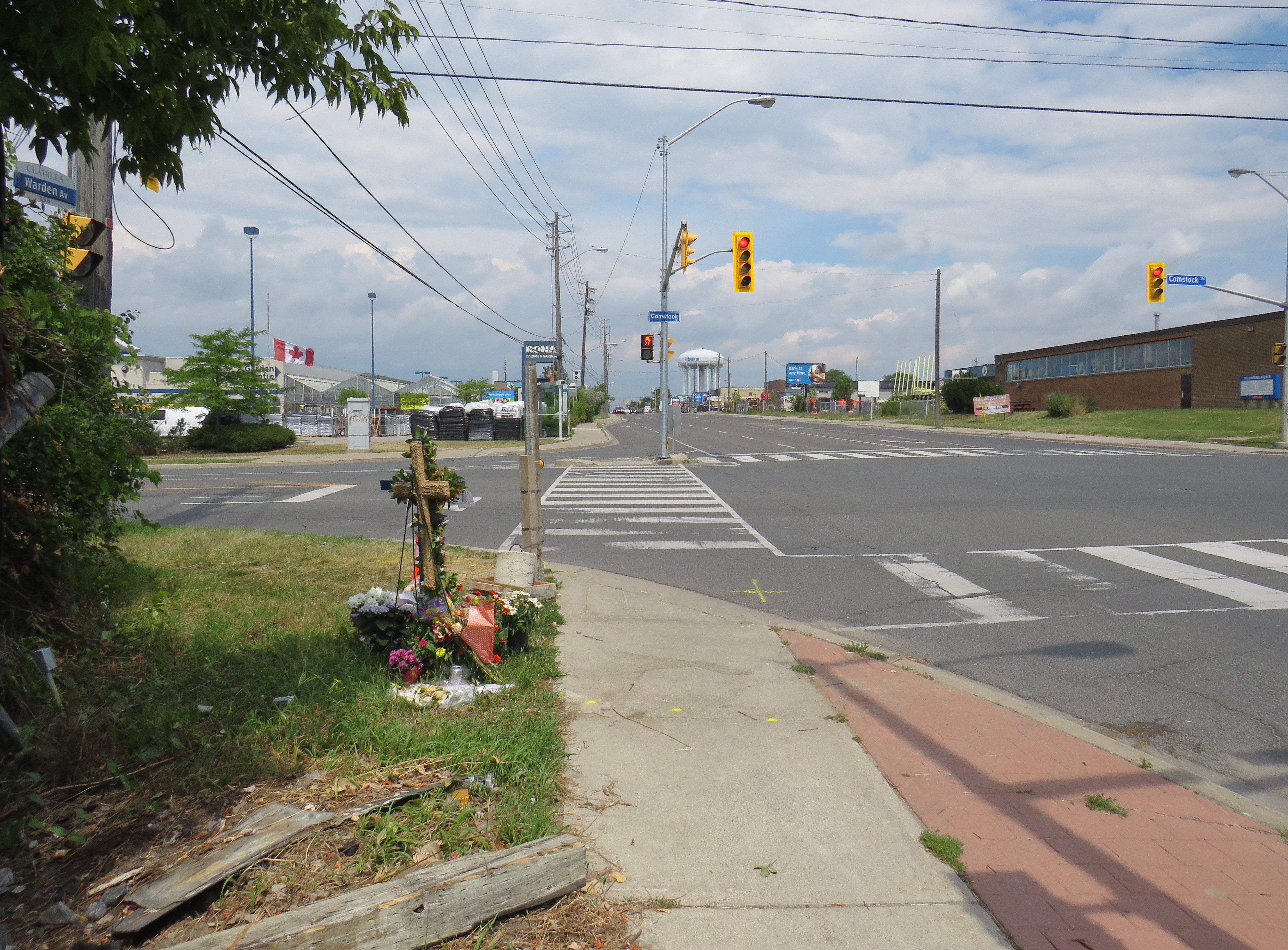
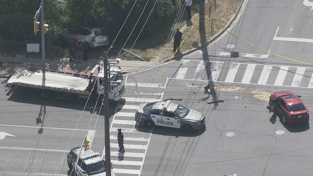
On Thursday, July 21, 2022, at 3:10 PM, a 38-year-old man was standing at a street corner in Scarborough, waiting for a signal to safely cross to the other side. Before he even had the chance to enter the intersection of Warden Avenue at Comstock Road, a driver of a 2009 silver Kia minivan heading south on Warden struck a 2012 red Lexus, whose driver was making a left turn from Warden to Comstock.
Aerial view of the collision, courtesy of CTV News. The Kia minivan struck a 38-year-old man waiting at the corner before plowing into a fence protecting a vacant lot.
A week after the deadly collision, I visited the intersection. On the southwest corner of Warden and Comstock, a roadside memorial was set up with flowers and a wooden cross. A temporary wooden pole held up a new pedestrian “beg button” for walkers to get across Warden Avenue. The Kia’s path into the sidewalk and the fence was very much visible, though all debris from the collision was cleaned up.
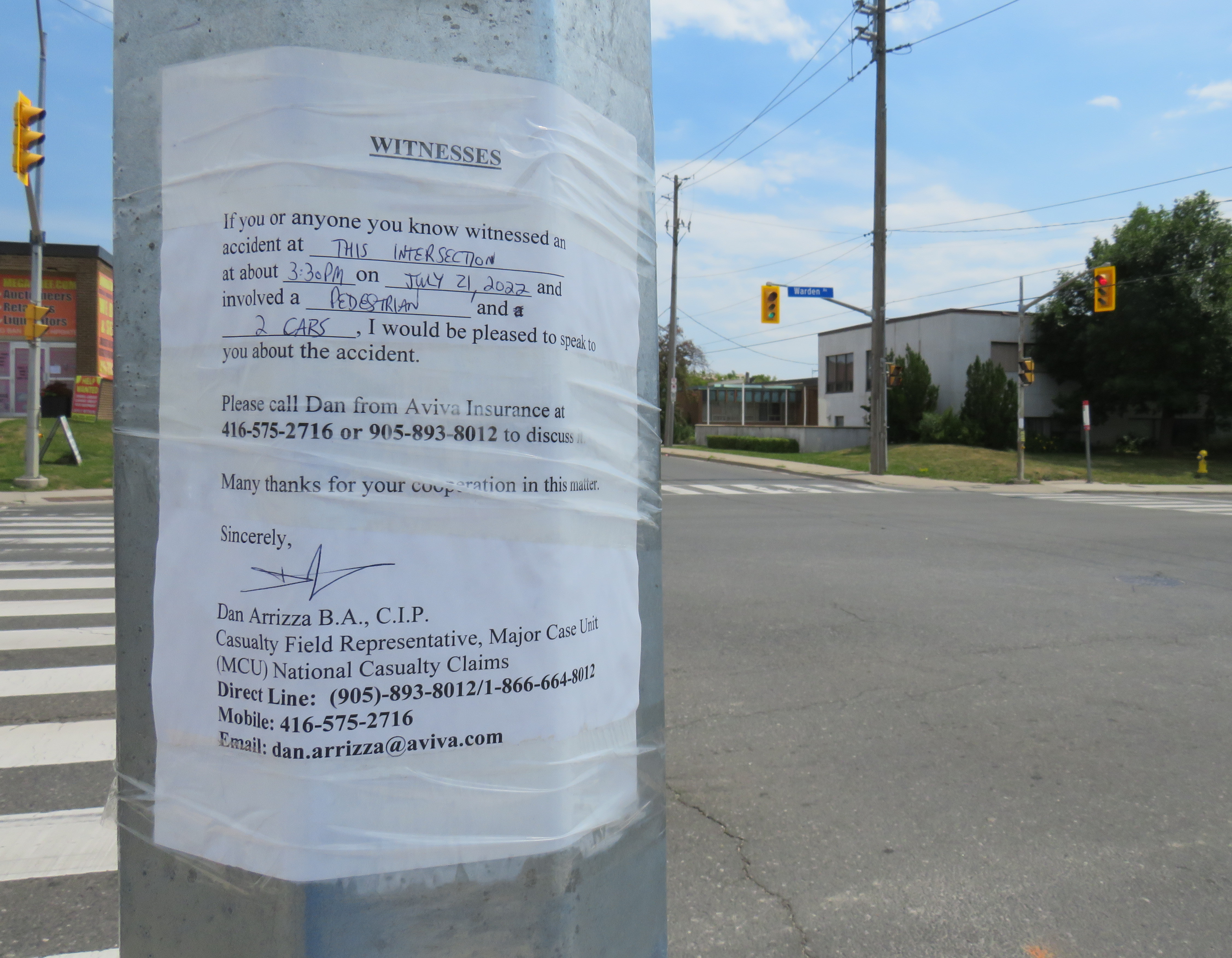
Appeal to witnesses following a deadly collision at Warden Avenue and Comstock Road
The collision was still being investigated. While the Toronto Police were looking for witnesses to the collision, an investigator from Aviva Insurance was also looking for witnesses; several notices were taped to nearby traffic poles.
Without knowing all the facts of the collision — which are unlikely to be reported in the news media — it would be fair to assume that speed and/or inattentive driving were at fault, but the design of the intersection — as well as Warden Avenue and Comstock Road themselves — are also to blame.
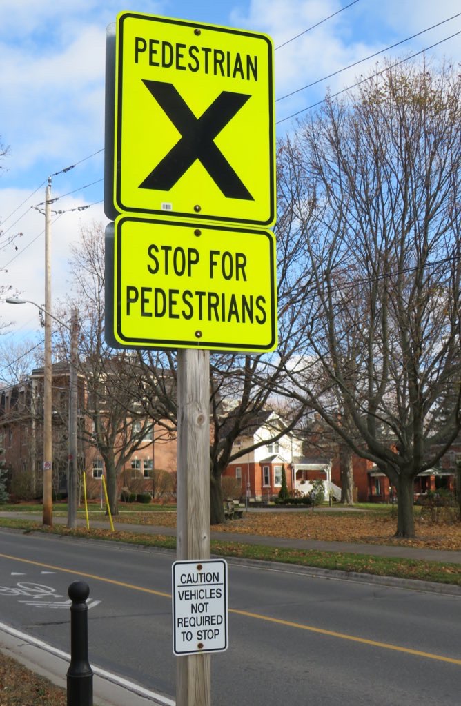
At the corner of King Street (former Highway 2) and College Street in Cobourg, adjacent to Victoria Park on the eastern edge of Downtown Cobourg, there’s a marked pedestrian crossing, with clear “zebra” road markings on the pavement.
The sign, in bright fluorescent yellow, reads “PEDESTRIAN X.” Below, a second sign, also in bright yellow, reads “STOP FOR PEDESTRIANS.” The message is clear enough.
However, a smaller white sign below, facing the sidewalk, reads “CAUTION – VEHICLES NOT REQUIRED TO STOP.”
On April 8, Toronto City Council approved a motion brought forward by Councillor Paula Fletcher to change that. Councillor Fletcher’s motion was titled “I’m Walking Here.” Only two months later, new signs are already appearing across Toronto — in Scarborough, Monarch Park, and Swansea. For a city that often takes years to adopt what may seem like simple, easy solutions, this was implemented impressively quickly. The new signs look like standard yellow “no exit” signs, but with a “pedestrians excepted” note at the bottom.
My hope is that these signs will entice Torontonians to get outside, go for a walk, and check out some new streets and parks, enticed by these signs inviting through passage.
In related news, this week Toronto Council approved the expansion of sidewalk slow clearance to all of Toronto’s streets, a service that was previously provided only to suburban areas, where unobstructed sidewalks made municipal slow clearance easy to do. With new snow equipment able to navigate narrow urban sidewalks, Toronto is now finally able to provide universal snow clearance services, a boon for full accessibility.
As public health restrictions ease and stores and restaurant patios reopen this Friday (supported by the city’s willingness to reallocate road space on streets like Yonge and Danforth), there’s never been a better time to for a walk.
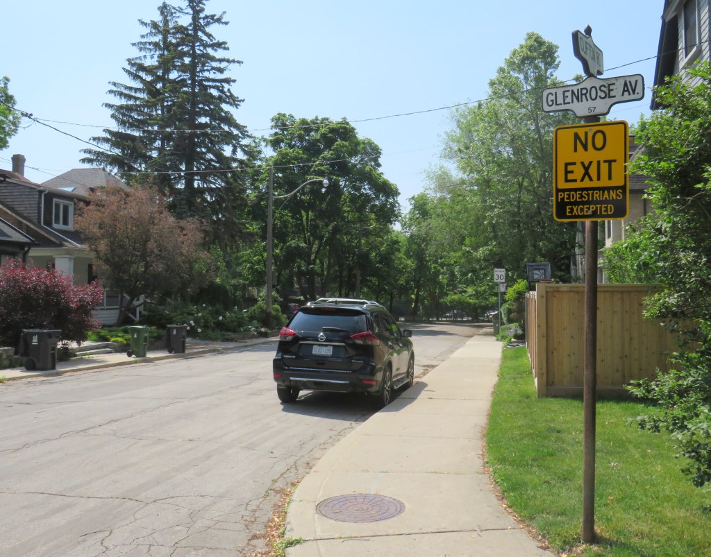
Misleading “no exit” signs, like these on Maitland Place at Jarvis Street, will soon be changed by the City of Toronto to indicate that indeed, pedestrians can continue through
Though these signs are required under traffic codes and regulations, they do not reflect that in many cases, there is an exit for pedestrians.
I quickly created a Google map of all locations in the City of Toronto marking such locations. Through a social media campaign led by Walk Toronto, we were quickly able to map over 450 locations where a pathway, sidewalk, or staircase allows a pedestrian to continue their way where motor vehicles are forced to turn around.
The motion, which was amended to strengthen the wording, requests city staff to develop a new signage standard to indicate where “no exit” signage betrays a pedestrian passage, and to begin installing these new signs this year.
Councillor Paula Fletcher’s motion (inspired by @Walk_TO) to have staff modify “No Exit” signage in places where there are, in fact, exits for pedestrians carries via show of hands, with some amended wording. https://t.co/owNfqtPgNUpic.twitter.com/eevn2bMwkN
The map that I created based on Dylan’s initial suggestion will be used to help identify these locations.
Given the ongoing pandemic, where we are all subjected to yet another lockdown, walking is one of the few permitted ways for each of us to get outside, enjoy the fresh spring air, and get much needed exercise. Knowing where one can walk, especially away from heavy traffic or busy sidewalks and paths, will only help unlock the city for more Torontonians.
I want to thank everyone who submitted locations for the map to Walk Toronto or to myself via Twitter or directly to me on this website. This couldn’t have happened without the help of fellow Torontonians.
The starting wage for an Amazon fulfillment centre employee is $17.00 an hour, despite notoriously tough working conditions. With most professional and office workers at home, and with ongoing pandemic restrictions, Amazon has enjoyed significant sales increases. But those workers picking and packing orders are not able to work from home – and workplace spread has been a significant factor in COVID-19 transmission in Ontario.
Brampton, home to two of the GTA’s fulfilment centres, and close to Amazon’s Mississauga, Milton and Bolton warehouses, has been a COVID-19 hotspot. Like Toronto, Peel Region has been under lockdown and stay-at-home orders since November.
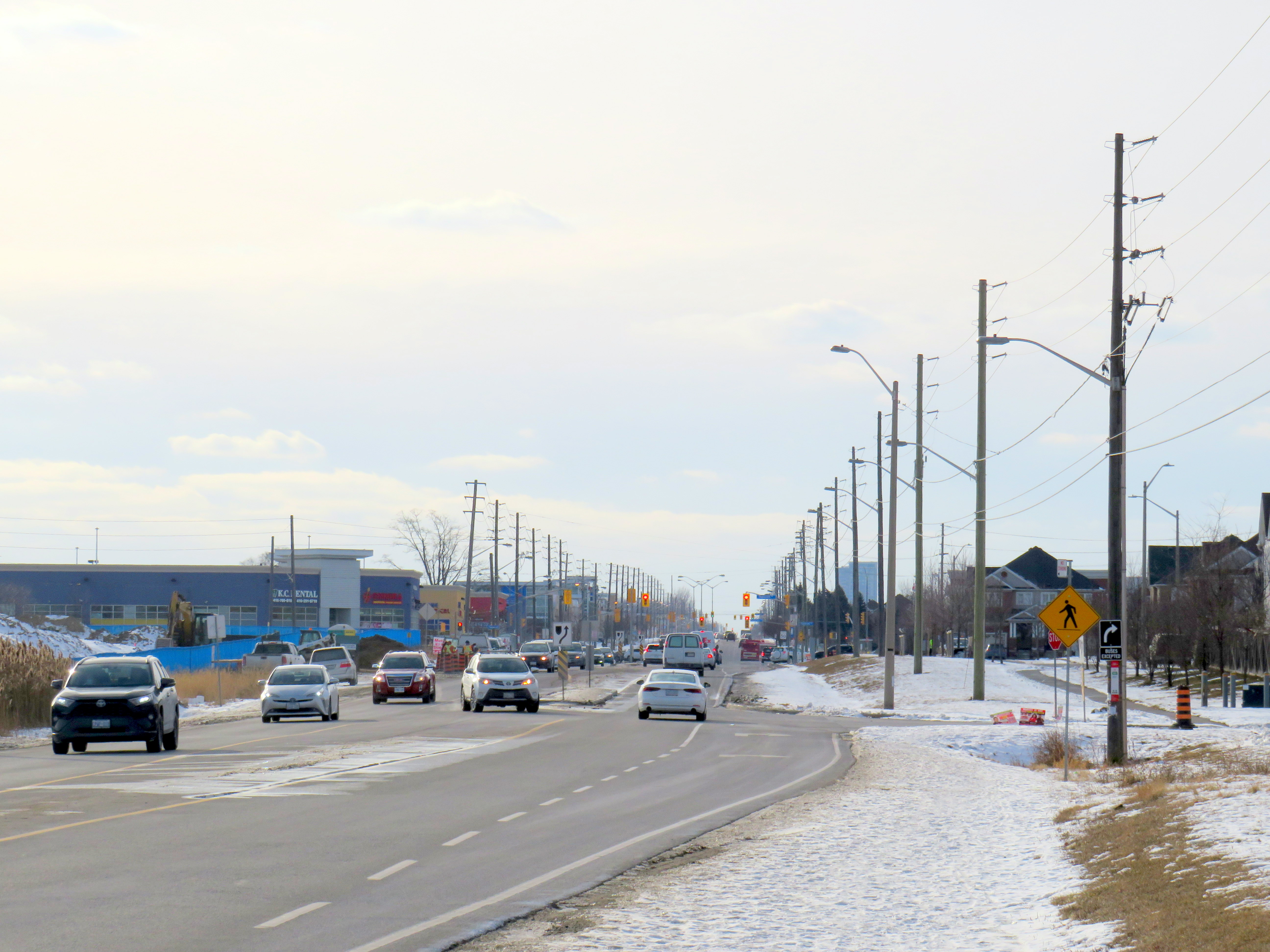
Like most new logistics facilities, the new Scarborough warehouse, like the other five GTA Amazon fulfillment centres, is in an industrial area on the city’s outskirts, where land is plentiful, but transit and pedestrian access is lacking. East of Tapscott Road, Steeles Avenue narrows from four lanes to two, and there are no designated pedestrian crossings at the intersection with Eastvale Drive. The eastbound TTC stop at Eastvale Avenue was removed in 2018 after a passenger was struck and killed trying to cross the street after disembarking from a 53 Steeles East bus. The next nearest stop, at Tapscott Road, is 300 metres west.
Steeles Avenue, looking west towards Eastvale Drive and the signalized intersection beyond, at Tapscott Road
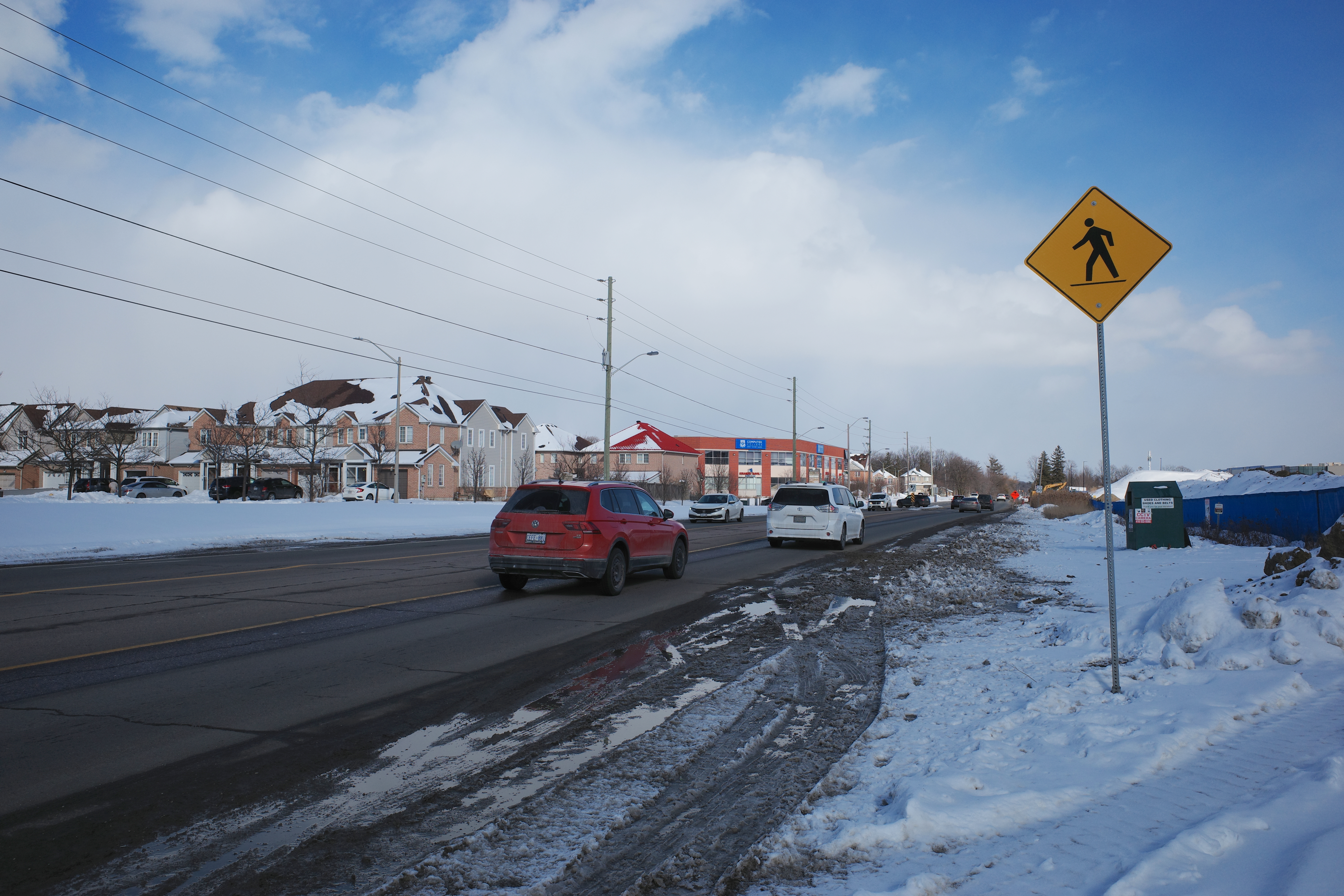
The sidewalk on the south side of Steeles Avenue ends at Tapscott, a few hundred metres west of the Amazon fulfilment centre. On the north side, the sidewalk ends at Ferncliffe Crescent in Markham. Despite a new residential area in Morningside Heights, to the east, there is no sidewalk along Steeles to connect to it. Pedestrians heading to Amazon or towards Staines Road must choose whether to walk in the mud, or on the busy roadway. Though the posted speed limit is 50 km/h, motorists regularly travel at 60 km/h or faster.
Looking east on Steeles from Tapscott Road – despite the sign advising motorists of pedestrian activity, there are no sidewalks leading east towards the new Amazon fulfillment centre (Sonali Praharaj)
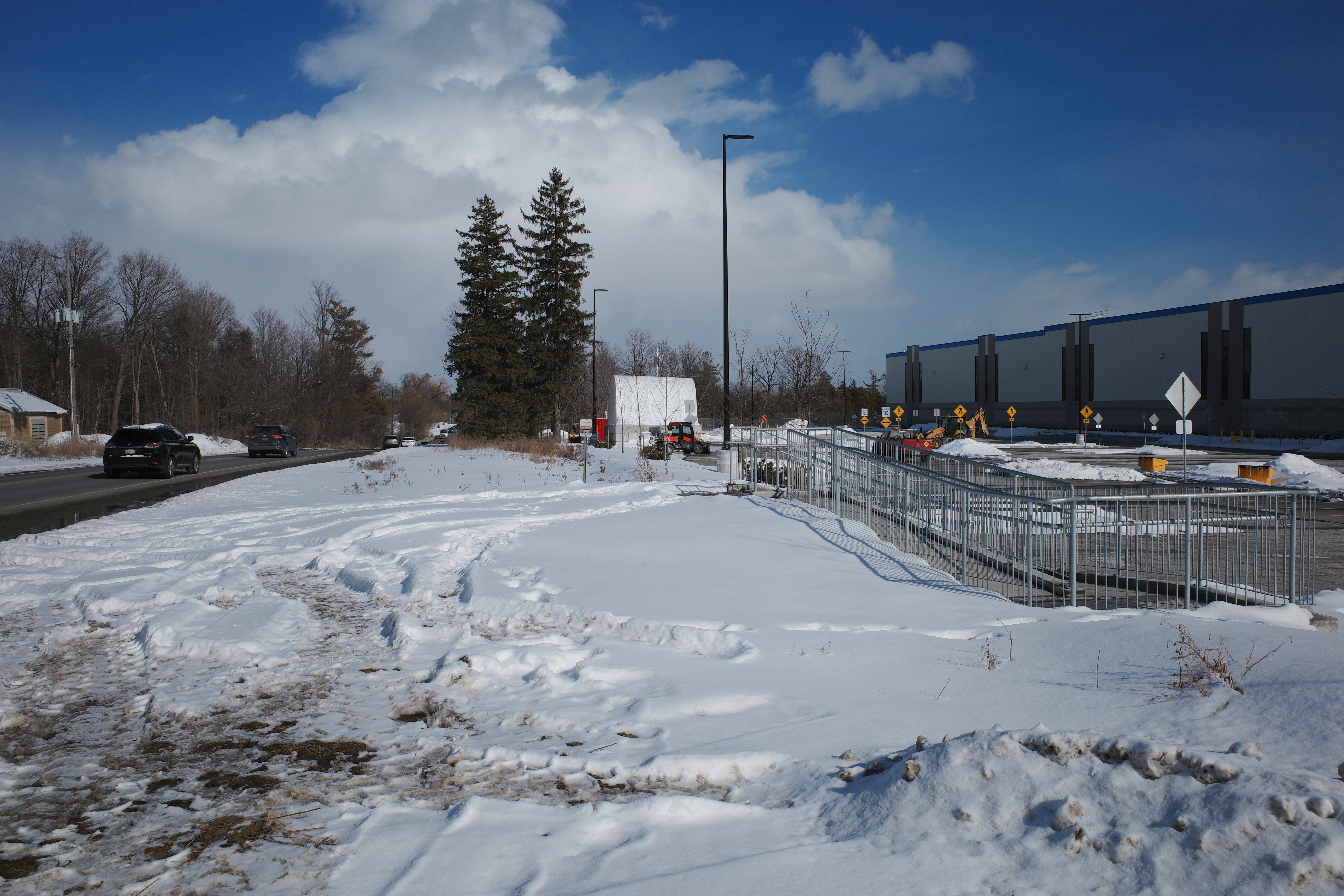
A stairway and ramp were built on the north end of the Amazon property, likely with the expectation that a sidewalk on the south side of Streeles Avenue would soon be installed. This would provide improved pedestrian access to the fulfillment centre. But without a safe and logical way to get to it from the street, it remains largely unused.
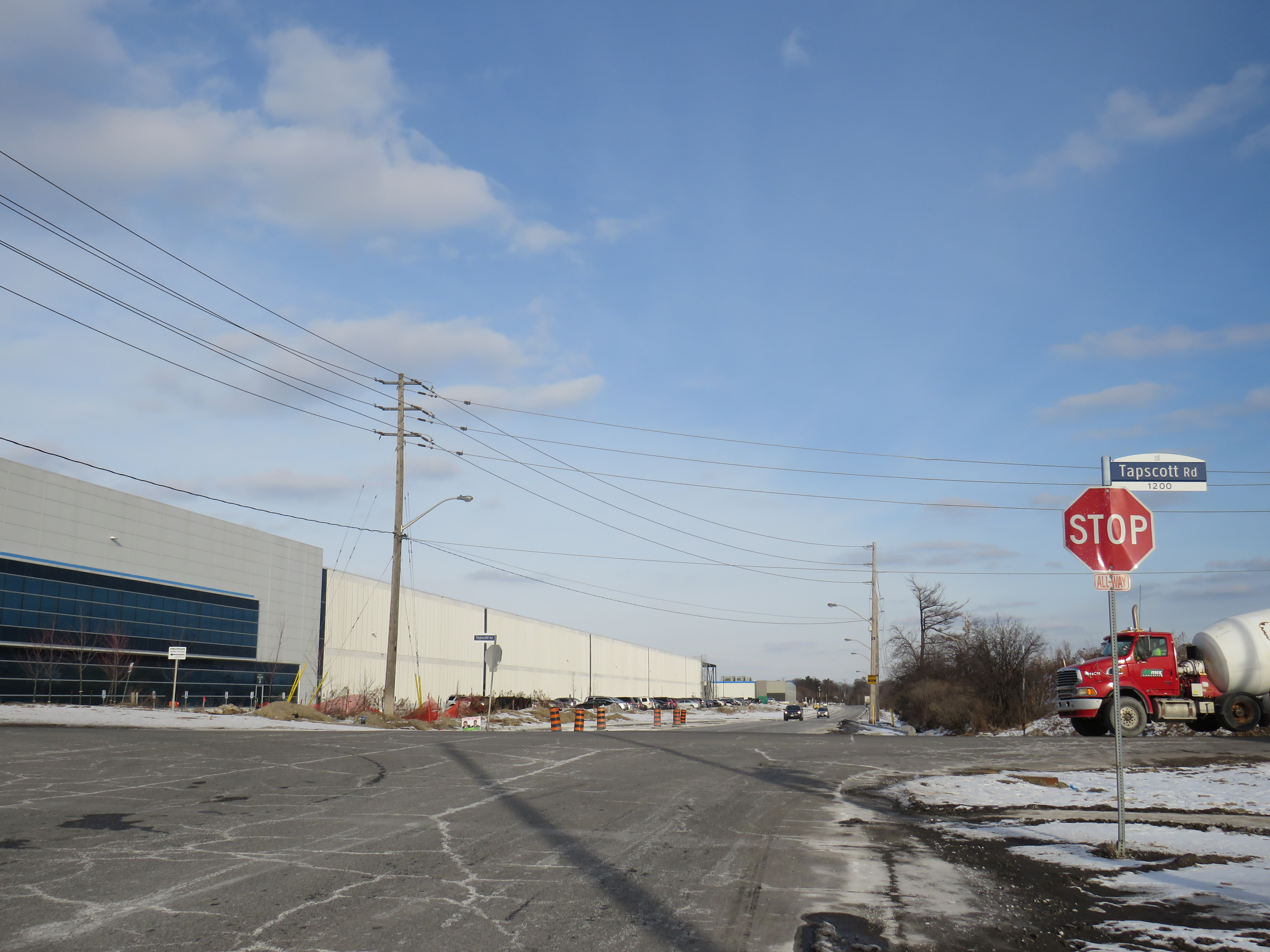
Passmore Avenue, on the south side of the fulfillment centre, was rebuilt with a sidewalk in the late fall of 2020, months after Amazon opened. However, it requires a lengthy walk north to Steeles Avenue up Tapscott, and there are no sidewalks on Tapscott from Passmore south, towards McNicoll Avenue. The intersection of Passmore and Tapscott itself – controlled by an all-way stop – still does not feature proper crosswalks.
Looking east on Steeles from Tapscott Road – despite the sign advising motorists of pedestrian activity, there are no sidewalks leading east towards the new Amazon fulfillment centre (Sonali Praharaj)
Though there are two TTC bus routes that operate to the corner of Tapscott Road and Passmore Avenue – 53B/953B Steeles East and 102B/C Markham Road – for months, workers had to walk on the roadway, through a construction site to access those buses. Anyone looking to go east, towards Morningside Heights, or southeast, towards Malvern, still face a long, dangerous walk or a lengthy bus commute.
The corner of Tapscott Road and Passmore Avenue
The TTC, starting January 11, 2021, began diverting the 53B Steeles East bus to directly serve the Amazon fulfillment centre, finally serving a major industrial trip generator and reducing essential workers’ travel times. Even still, the new sidewalk on Passmore ends at the warehouse entrance – anyone waiting for a bus must still walk and wait in the snow or mud.
Eventually, Steeles Avenue will be widened, with new sidewalks and bike lanes, and Morningside Avenue will be extended north to Steeles Avenue. However, these improvements have been planned for years and completion is still several years away. Though new warehouses have opened here, civic infrastructure has not caught up.
New TTC bus stop serving the Amazon Fulfillment Centre on Passmore Road (Sonali Praharaj)
The TTC’s service change, adding a new bus stop on Passmore Avenue, was a welcome – yet overdue – acknowledgement that essential workers, especially racialized and lower-paid workers, deserve better. It is inexcusable that new employment uses are planned, approved, and constructed before the appropriate pedestrian infrastructure and transit services are in place. It is also inexcusable that after a TTC customer was killed that a nearby bus stop was removed, rather than safety improvements added instead. This is not just a matter of ensuring a basic level of safety for pedestrians – this is a matter of justice for those we consider essential workers.
At least the new Yonge Street Rapidway would serve York Region’s busiest transit corridor, supporting new high-density development in Richmond Hill. Unlike on Highway 7 or in Newmarket, there are no two-phase pedestrian crossings on this part of Yonge. Unfortunately, a botched connection between the new Rapidway at Major Mackenzie Drive created a new problem for the YRT/Viva transit network.
This issue — along with the other problems with York Region’s Rapidways that I discussed previously — should be held up as lessons on what not to do when building new transit rights-of-way in street medians, be it on Hurontario Street in Mississauga and Brampton, planned BRT lines on Dundas Street in Mississauga, or Queen Street in Brampton.