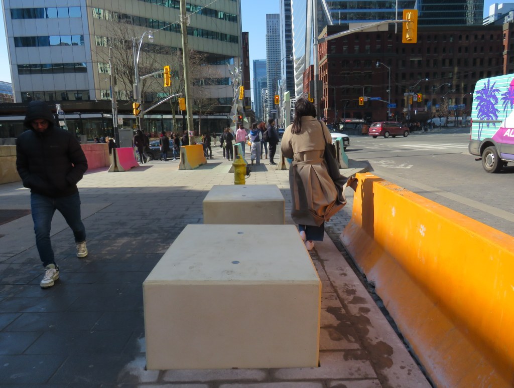
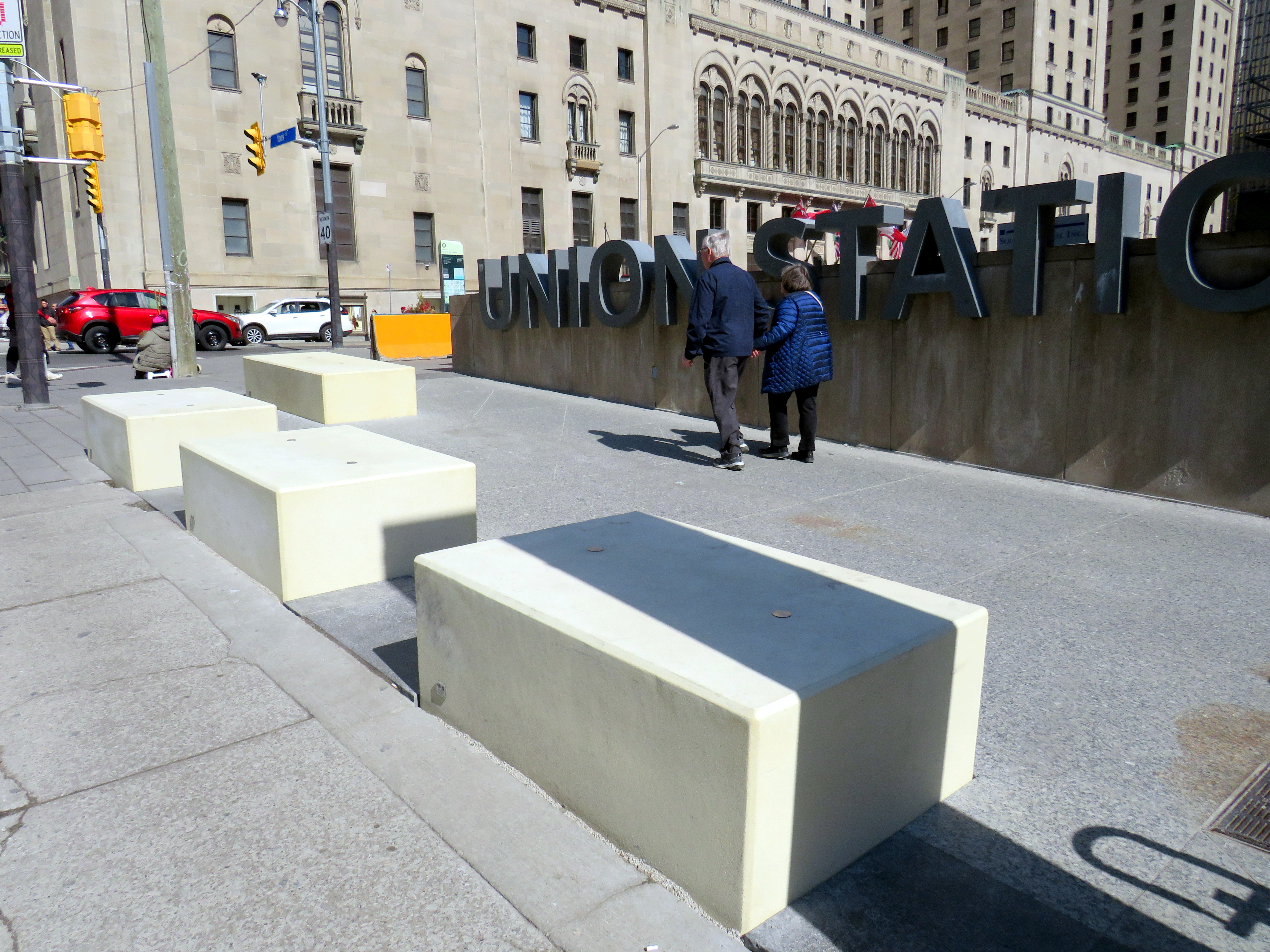
New blocks installed in front of Union Station at Front and York Streets
When I learned that Union Station was finally getting permanent bollards to replace the haphazardly-placed Jersey barriers that have sat in front of the transport hub since 2018, I was relieved. I wrote about these barriers several times on this website, criticizing their appearance and their placement, blocking the way for the thousands of people who cross Front Street every day. But when I went to see them in person, after seeing criticism online, I was dismayed.
The new permanent barriers might even be worse than the temporary obstructions they are meant to replace.
The Jersey barriers were hastily placed after a tragic attack on Yonge Street in North York, where a man intentionally drove a rented van on to the sidewalk, killing ten pedestrians and injuring and traumatizing many more.
Vehicular assaults on crowds of pedestrians are a major concern; tactics used at mass gatherings — such as the winter light show and New Years Eve events at Nathan Phillips Square and major concerts and playoff games at Skydome and Scotiabank Arena — now include blocking closed streets with heavy vehicles such as snow plows, dump trucks, and city buses. However, Union Station is the only place in the city where officials have decided that new permanent barriers were necessary.
Union Station is one of the busiest pedestrian areas in the city
The new permanent barriers are not the sturdy, yet narrow, bollards that are used elsewhere. Instead, they are large, undecorated concrete blocks anchored into the ground and are knee-high. The plain concrete colour does not match the stone sidewalks or plaza. They are placed very close together, impeding access for those using large carts, strollers, or wheeled mobility devices. Despite all the money spent renovating Union Station, these blocks look cheap.
Concrete blocks at the corner of York and Front Street at Union Station
The total cost of installing the “Custom Anti-Terror Concrete Barriers,” as the city described the bid, was $2,438,238, including HST. The lowest bid, by South Central Inc., came over a $1 million cheaper than the other two bids. It is worth noting that there are no public documents that describe the city’s specifications for the contract, nor was there any public consultation before the city solicited bids.
The result? An esthetic failure and an accessibility challenge.
Video showing pedestrians going around the concrete blocks in front of Union Station
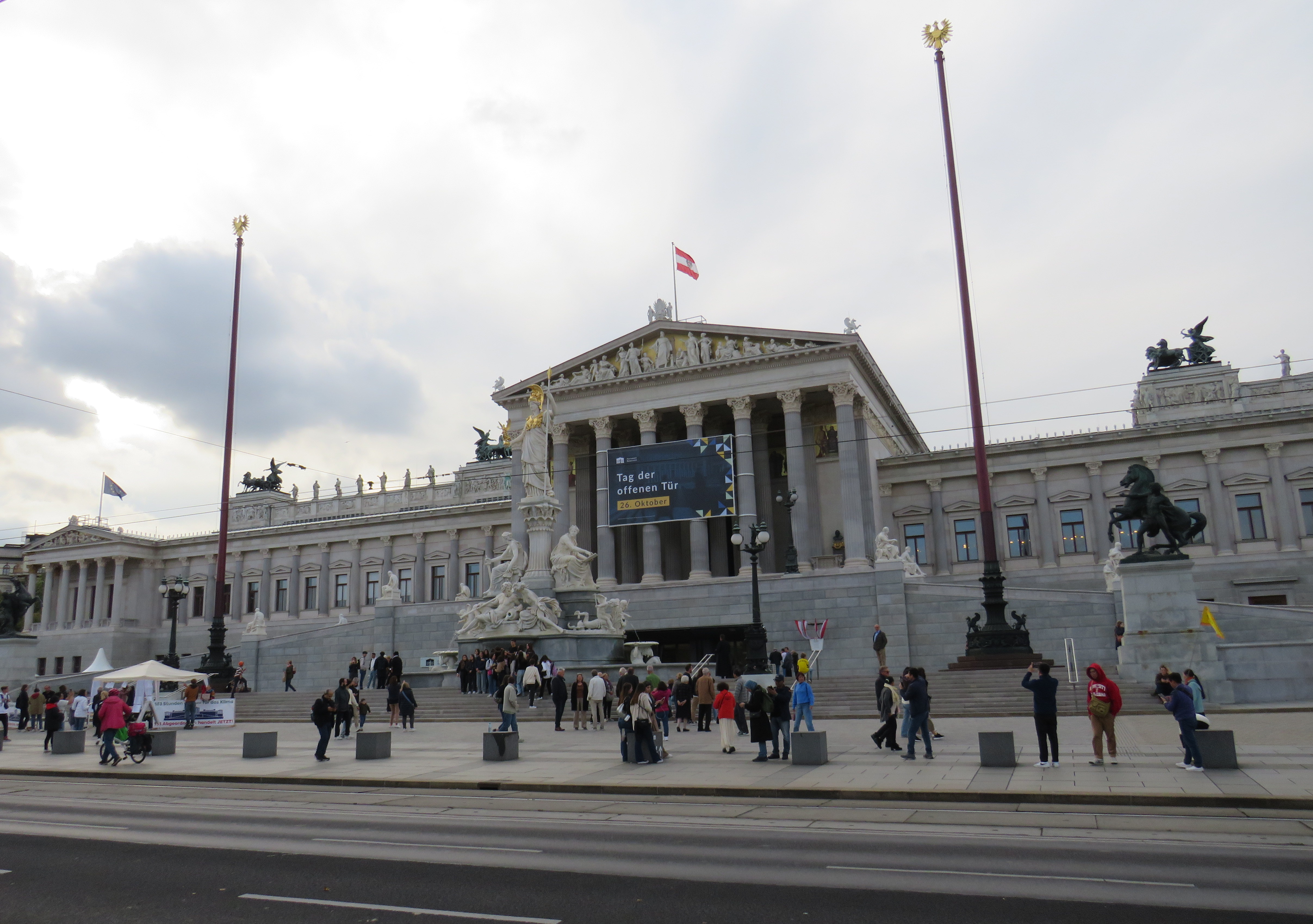
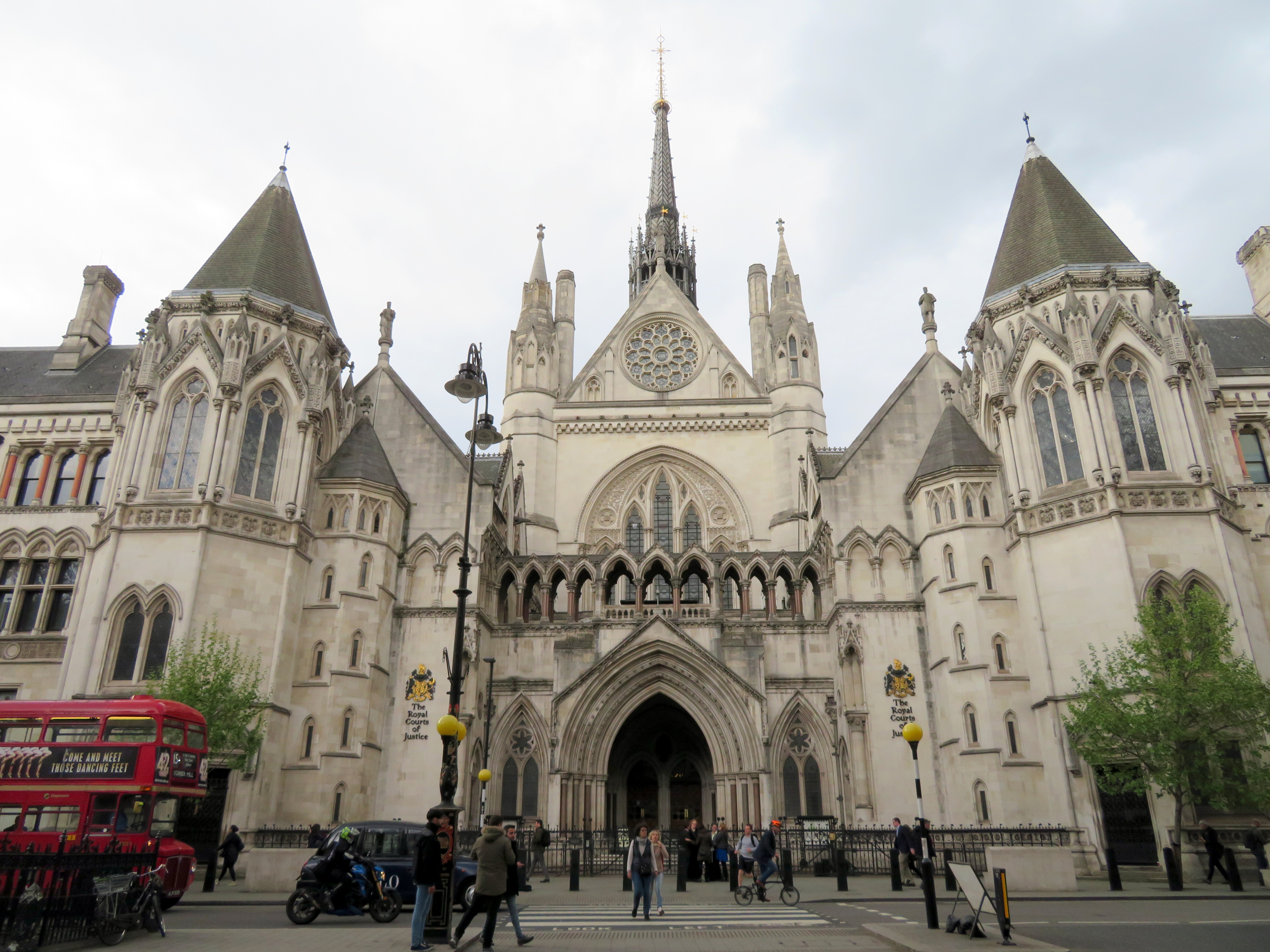
I cannot understand the city’s decision to go with these blocks where more elegant and pedestrian-friendly alternatives are typically used elsewhere. For example, the Austrian Parliament Building in Vienna, which faces the famous and busy Ringstrasse, is protected by smaller concrete bollards, which are also more widely separated, making it much more pleasant for pedestrians to get by. In Great Britain, metal bollards are common on busy commercial streets and in front of important buildings, but they are easy for pedestrians to pass, and generally blend in.
Thick concrete bollards in front of the Austrian Parliament Building, 2023Metal bollards in front of the Royal Courts of Justice in London
In the United States, government buildings are also protected by heavy anti-vehicular barricades (especially since the 1995 Oklahoma City bombing), but they are generally more permeable for pedestrians.
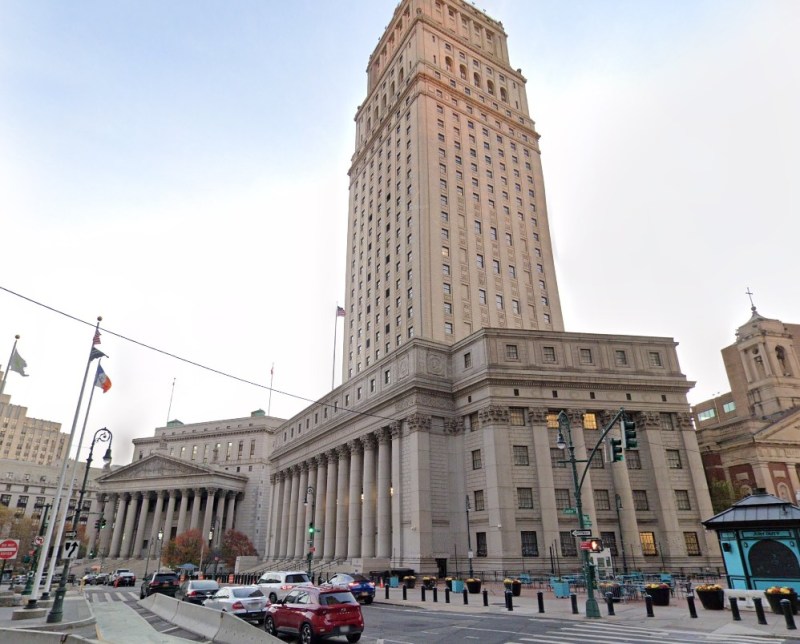
Metal bollards protect the federal courthouse in Downtown Manhattan (Google Streetview)
It is also worth noting that other popular pedestrian areas, such as the Yonge-Dundas intersection, are not protected from a potential vehicular attack — or an unintentional collision. It is beyond comprehension why the city only focused on protecting one pedestrian area, using such a poorly thought-out design. Toronto can — and should — do better.
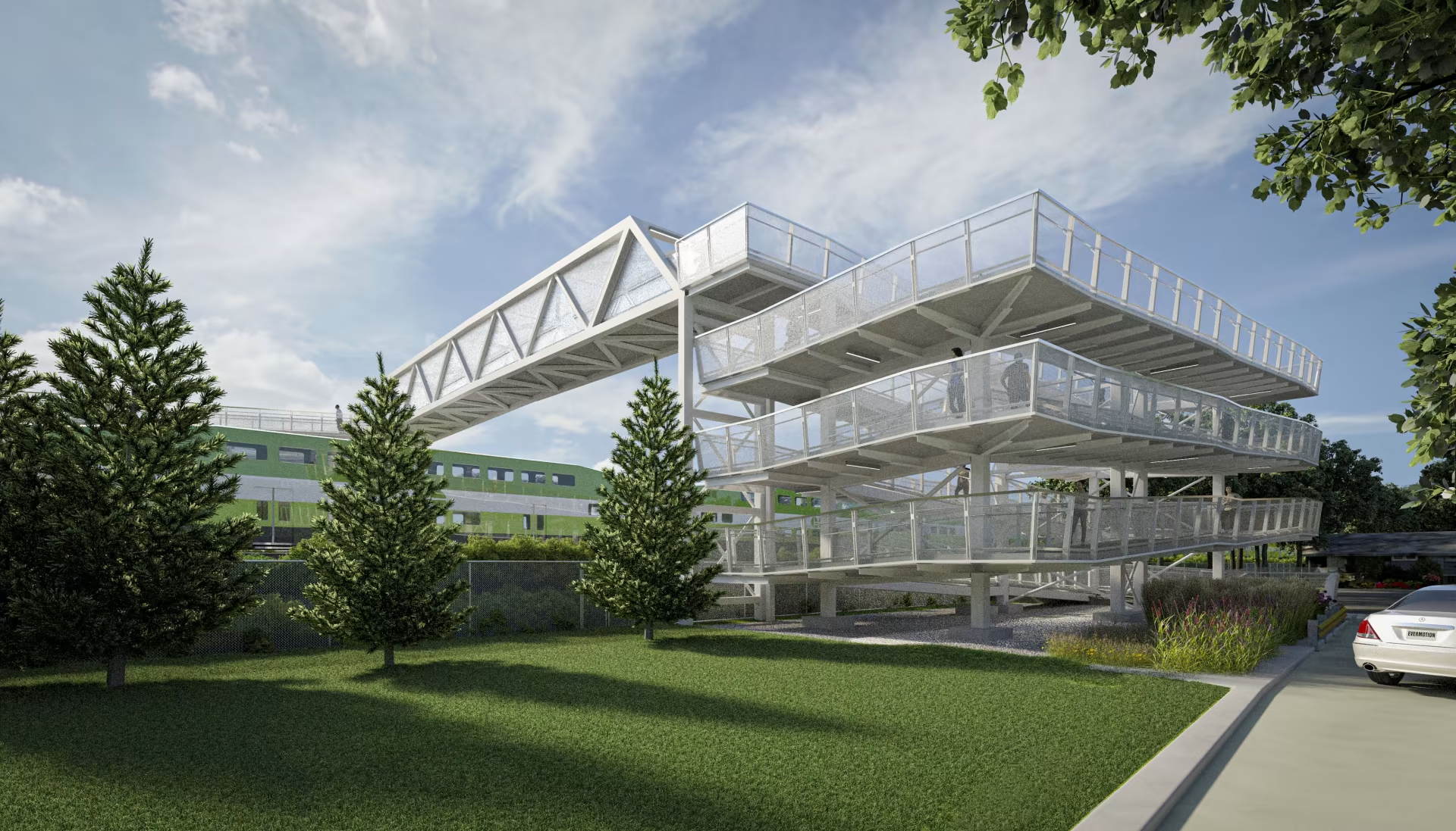
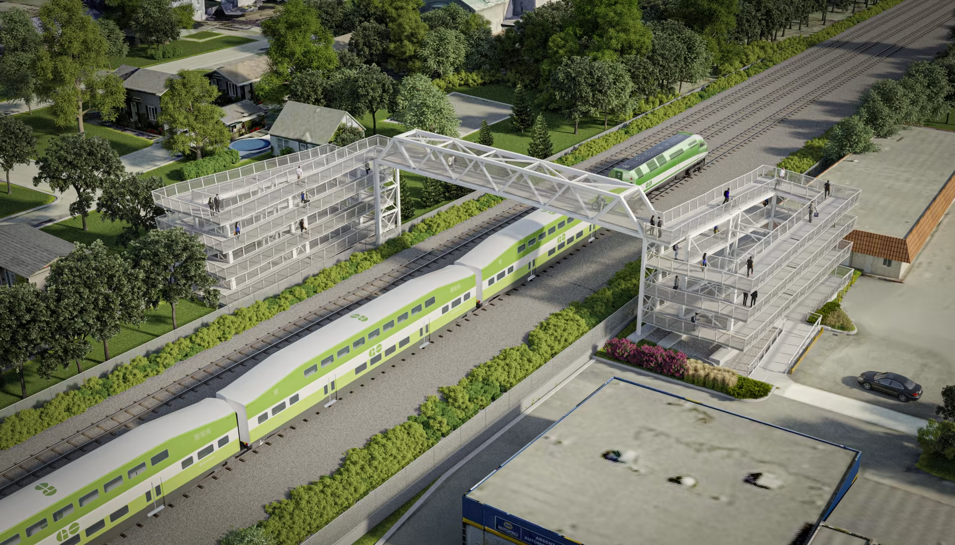
Metrolinx rendering of the planned new Drury Lane pedestrian overpassin Burlington
On the home page of Metrolinx, the provincial agency tasked with building and operating regional transit in the Greater Toronto and Hamilton Area and beyond, there is a statement under the heading “Connecting Communities.”
The Greater Golden Horseshoe is growing, and you need to get places. Our transit projects will connect new, established and emerging communities across the Greater Golden Horseshoe. – Metrolinx
Unfortunately, the very same transit projects and rail corridor upgrades can serve to disconnect, rather than connect, communities. Too often, GO Transit lines are secured without regard to the neighbourhoods they run through, without simple and convenient crossings for pedestrians and cyclists. Where overpasses are provided, they are built in such a way that makes them more difficult than necessary to cross.
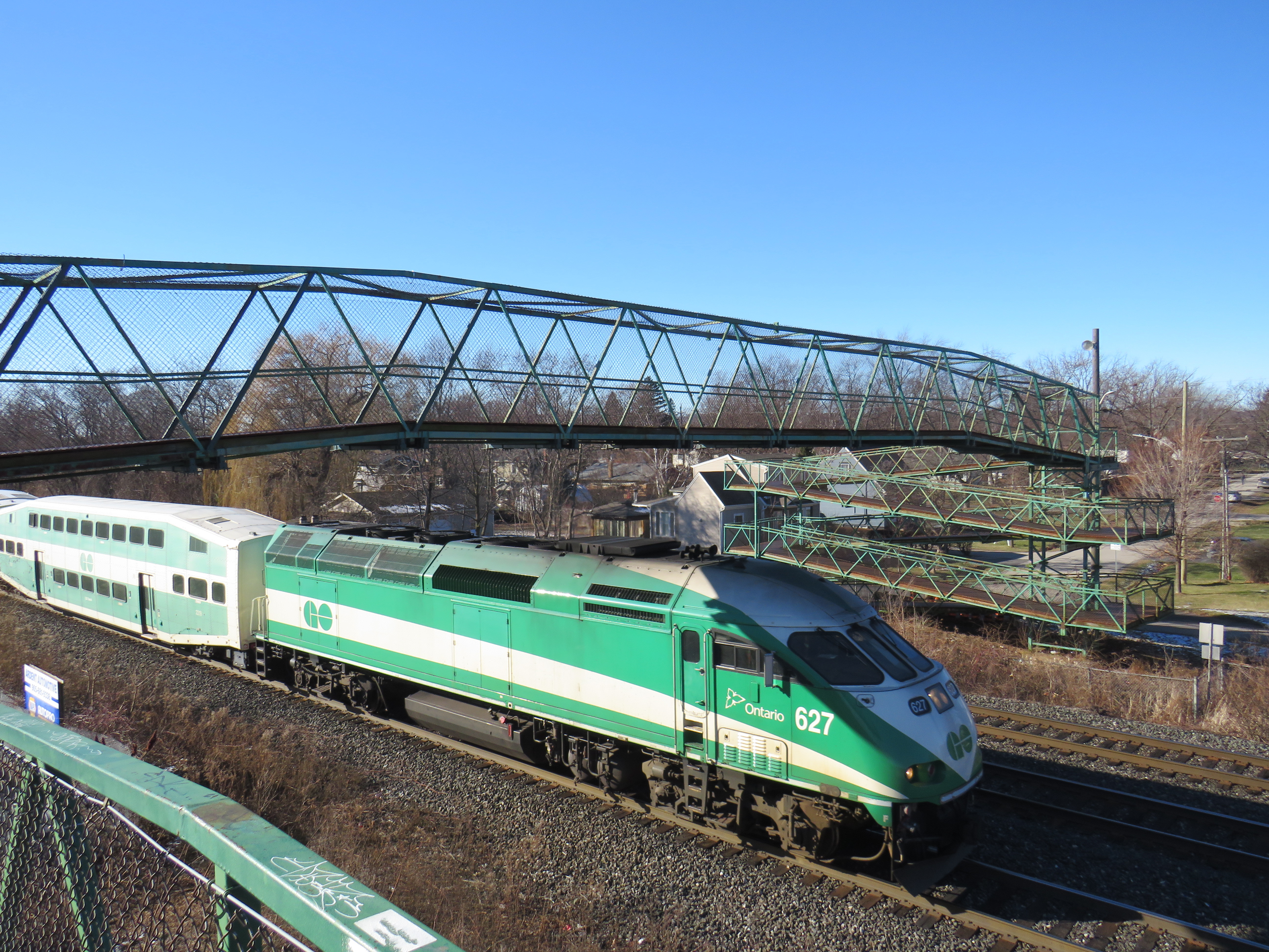
A GO Transit train passes under the existing Drury Lane pedestrian overpass
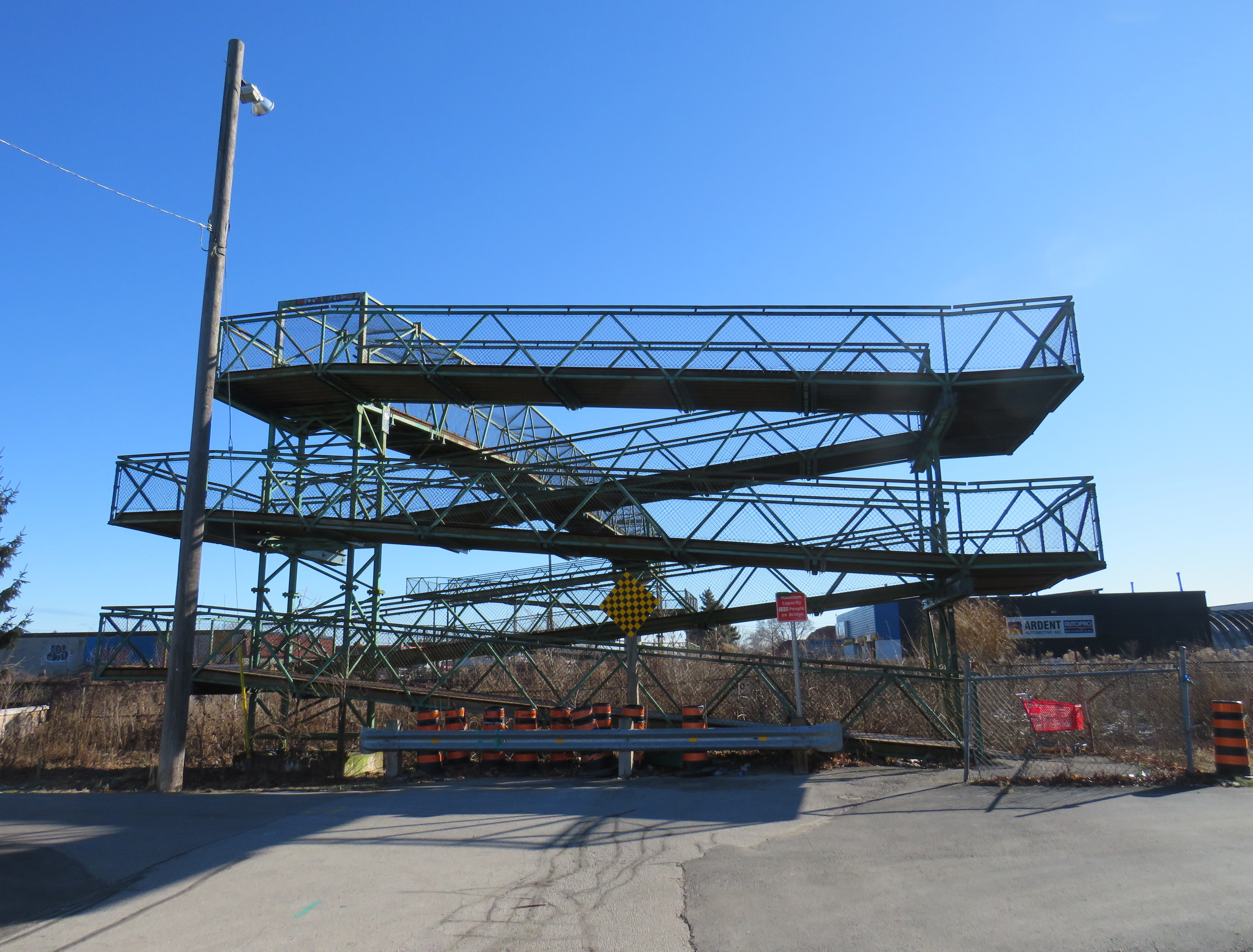
Take the example of the planned replacement of the Drury Lane pedestrian overpass in Burlington, which connects Fairview Avenue to the south and Orpha Street and a postwar residential neighbourhood to the north. With Burlington GO Station only 500 metres to the west, the pedestrian overpass provides a useful connection to GO and Burlington Transit services as well as (the station’s north end is poorly connected to the Orpha Street area, it is primarily a motor vehicle access to a large parking structure). Drury Lane continues south of Fairview Street towards Burlington’s Central Park, the city’s main library branch, and leads towards the waterfront and downtown core. Unlike Brant Street, Fairview Street, or Guelph Line, Drury Lane is relatively quiet, with painted cycle lanes.
The planned new Drury Lane pedestrian overpassin Burlingtonwith lengthy access ramps
The new overpass, replacing the existing 50-year-old structure, will be taller, with longer approach ramps. Metrolinx touts the improved accessibility of the new bridge, even though it will add more time to travel times with an extra ramp segment on each end. No stairs are provided to provide a short-cut for those able to navigate steps.
The new bridge’s increased height will provide additional clearance for the planned electrification of the Lakeshore West rail corridor.
Existing ramps at the north (Orpha Street) end, which requires three full turns to reach the top
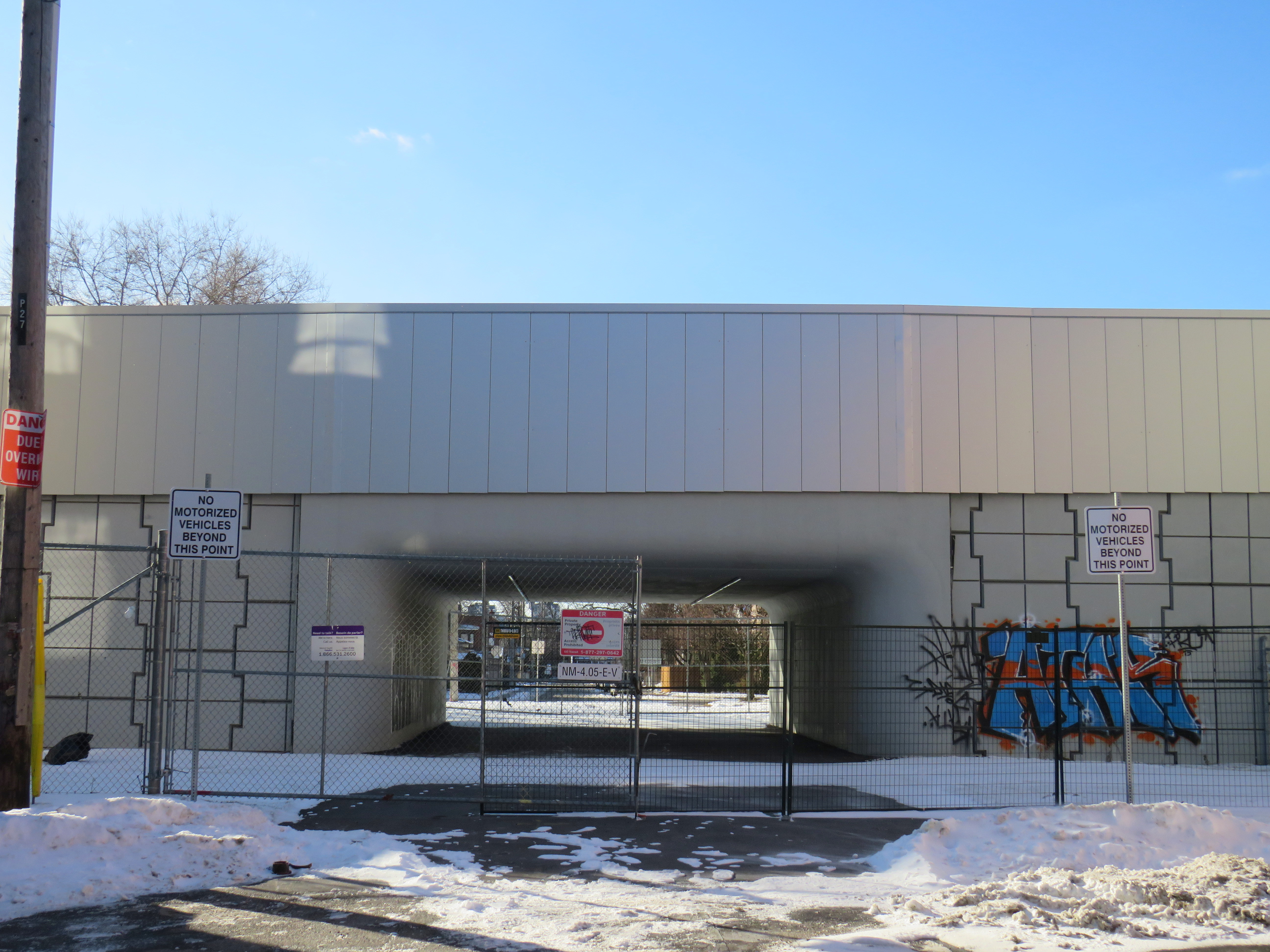
A simpler solution would have to build an underpass, which would require a much shorter vertical route for pedestrians and cyclists. Indeed, the rails are on a slight embankment above street level already. A wide, well-lit underpass would improve accessibility; in fact, pedestrian underpasses are provided at nearly all GO rail station where grade separations are required as they provide quicker and easier access between platforms and the station building, parking and bus stops.
Though it has yet to open, the Paton Road connection under the GO Barrie Line in Toronto shows how a wide pedestrian underpass could look.
There are many other opportunities for safe and accessible pedestrian and cycling infrastructure along GO Transit corridors. The best example might be in North York, where the combination of a Metrolinx rail corridor and a twelve-lane Highway 401 make pedestrian and cyclist movement especially difficult and unsafe. At one time, it was easy (though still illegal) to cross the tracks between Floral Parkway, a residential street running east-west from Keele Street to the GO Barrie Line, to Bridgeland Road, an industrial street connecting to Caledonia Road and leading towards Yorkdale Mall.
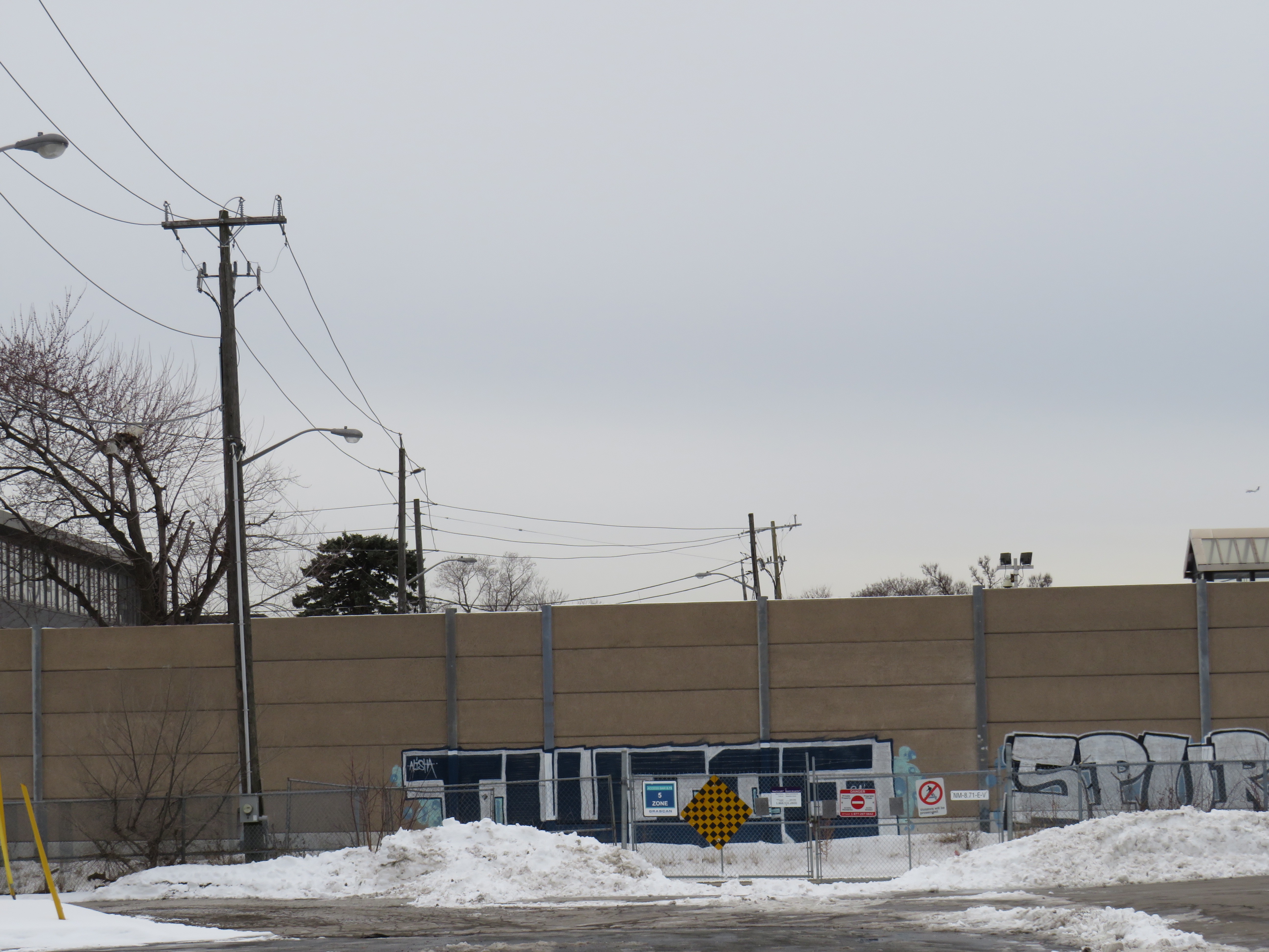
By the late 2000s, new fencing was put up to prevent pedestrian crossings here; this was further upgraded with reinforced chainlink fences, and more recently, a noise wall. Metrolinx knew this was a popular place to cross, but instead of providing a safe route (either a signalized and gated at-grade crossing, an overpass, or an underpass), it worked only to harden its property.
The highly-secured Bridgeland Road/Floral Parkway crossing in 2013The Bridgeland/Floral crossing in January 2025, with a noise barrier completely blocking Floral Parkway from the tracks
As new high-density residential development is nearing completion at Dufferin and Bridgeland on the site of an old Holiday Inn, as well as mixed-use development planned at Yorkdale Mall and a major hospital at Keele and Highway 401, there is even more of a need for sustainable, safe, active transport. The walk between Floral Parkway and Bridgeland Road is 49 minutes; the Highway 401 interchanges at Keele and Dufferin are also unsafe to navigate by foot or bicycle; fast moving traffic and narrow sidewalks make them unpleasant as well.
We need local and provincial officials to push for safe and accessible access across transit corridors and major highways for all users, but especially pedestrians and cyclists who are typically overlooked when these projects are planned and built.
Though transit construction is very beneficial for the region’s growth, it is still frustrating when an agency tasked with “[connecting] new, established and emerging communities across the Greater Golden Horseshoe” fails to connect the communities its transit projects run through.
Last month, I wrote about the challenges getting around Toronto’s Union Station, Canada’s busiest transportation hub, particularly for passengers using mobility devices or carrying luggage. Only one poorly-marked elevator directly links the Great Hall and the UP Express platform with the subway station/PATH level, which is located two floors down.
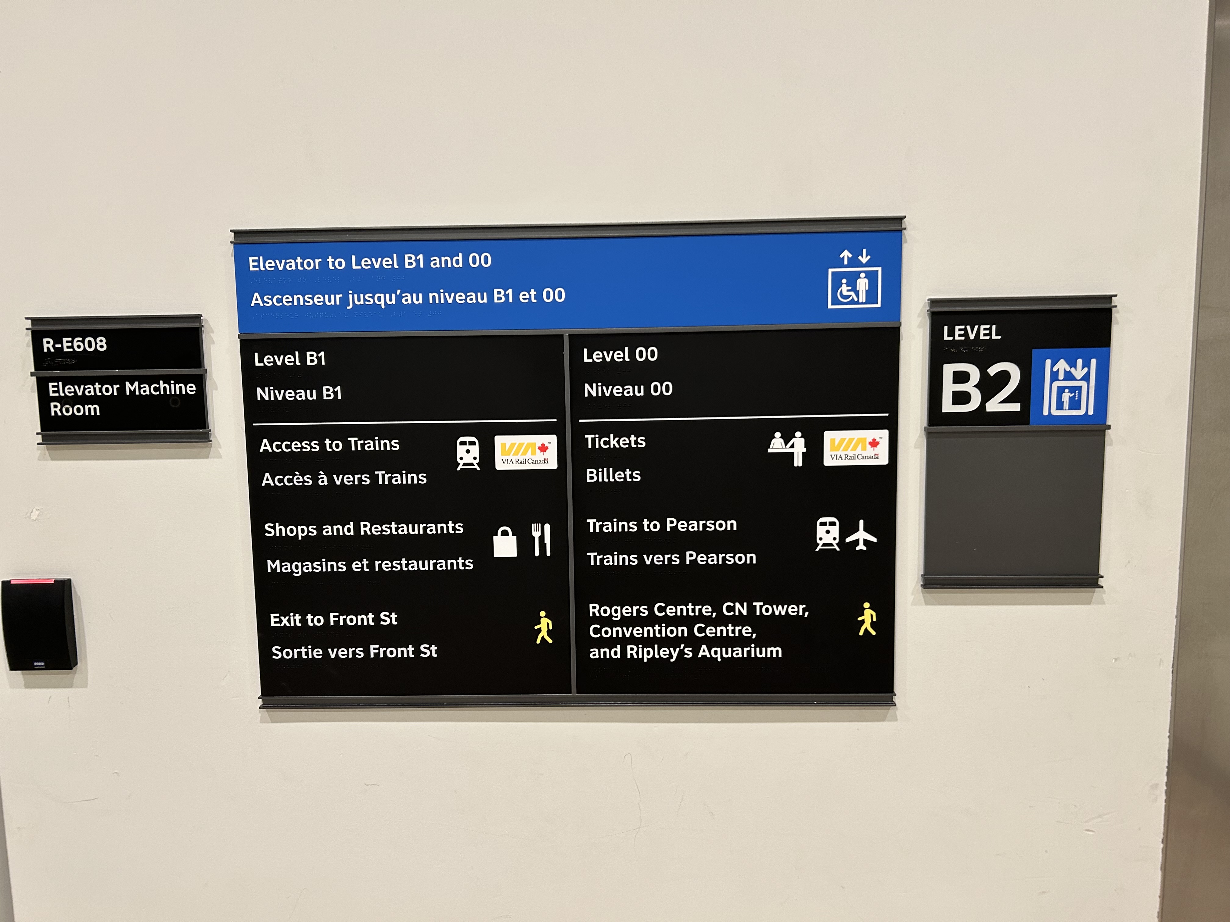
I returned to Union Station on Tuesday, January 7, to see if any improvements were made since I wrote my initial post. Somewhat surprisingly, new signs were installed beside the elevators, indicating which floor goes where.
Elevator signage at B2 level (subway concourse/PATH level by Bay Street) that indicates where the other floors lead to: Level B1 for VIA trains, shops and restaurants, and exit to Front Street, and Level 00 for VIA ticketing, UP Express trains, and access to the Skywalk to Rogers Centre, CN Tower et al.In the GO York Concourse, the elevator leads to Level 00 (The Great Hall) only.
These signs are a notable improvement, but there is still no signage inside the elevator cars themselves, so the traveler must note the directory signage before entering the elevator. Furthermore, the Great Hall, the historic centrepiece of the Union Station complex, is not noted, even though it is a logical meeting place from where access to all GO, VIA, and UP Express train services can be made, or where taxis can be found right outside.
Unfortunately, the elevators themselves are still difficult to locate, and the decision to have just one slow elevator connect the Great Hall/UP Express floor with the subway station entrance remains unfortunate. There is still so much more to be done.
In the Great Hall, there are clear signs directing passengers towards the subway, but there are no indications on where a barrier-free passage can be found. A supplementary sign pointing towards the one elevator, located at the far end of the Great Hall, could be useful here.
Previously on this website, I discussed the problems with the unsightly, intrusive, and poorly thought-out mess of Jersey barriers plopped in front of Union Station along Front Street. They have not only been an eyesore unbefitting a signature heritage structure, but they have also been difficult for pedestrians to navigate around, especially at the corners of Front and Bay and Front and York.
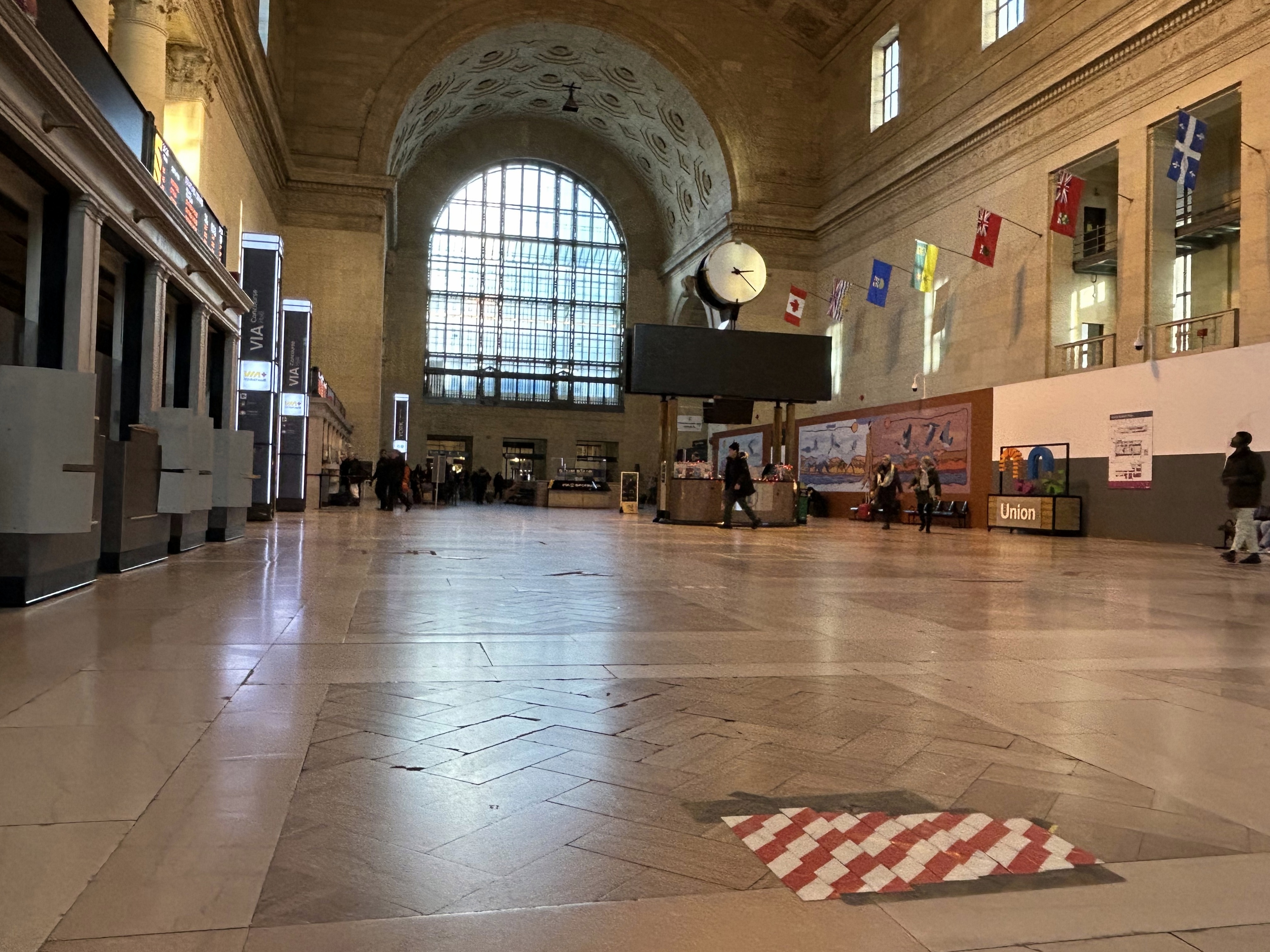
Inside Union Station, however, a lot has changed in the last few years. In general, pedestrian flow within the station building has improved, especially with the opening of the GO Transit York Concourse, which provides a second access point for regional trains. Flow between subway, train, and shops is considerably improved; there are also a lot more food and retail options befitting a central transport hub.
Despite new escalators and elevators, accessibility in Union Station remains poor. Though technically, the station is fully accessible to anyone using a wheelchair or other mobility device, the wayfinding is absent in key areas. There is only one small elevator that directly connects the subway level with the Great Hall, UP Express trains, and Front Street. An accessible route is also difficult to find.
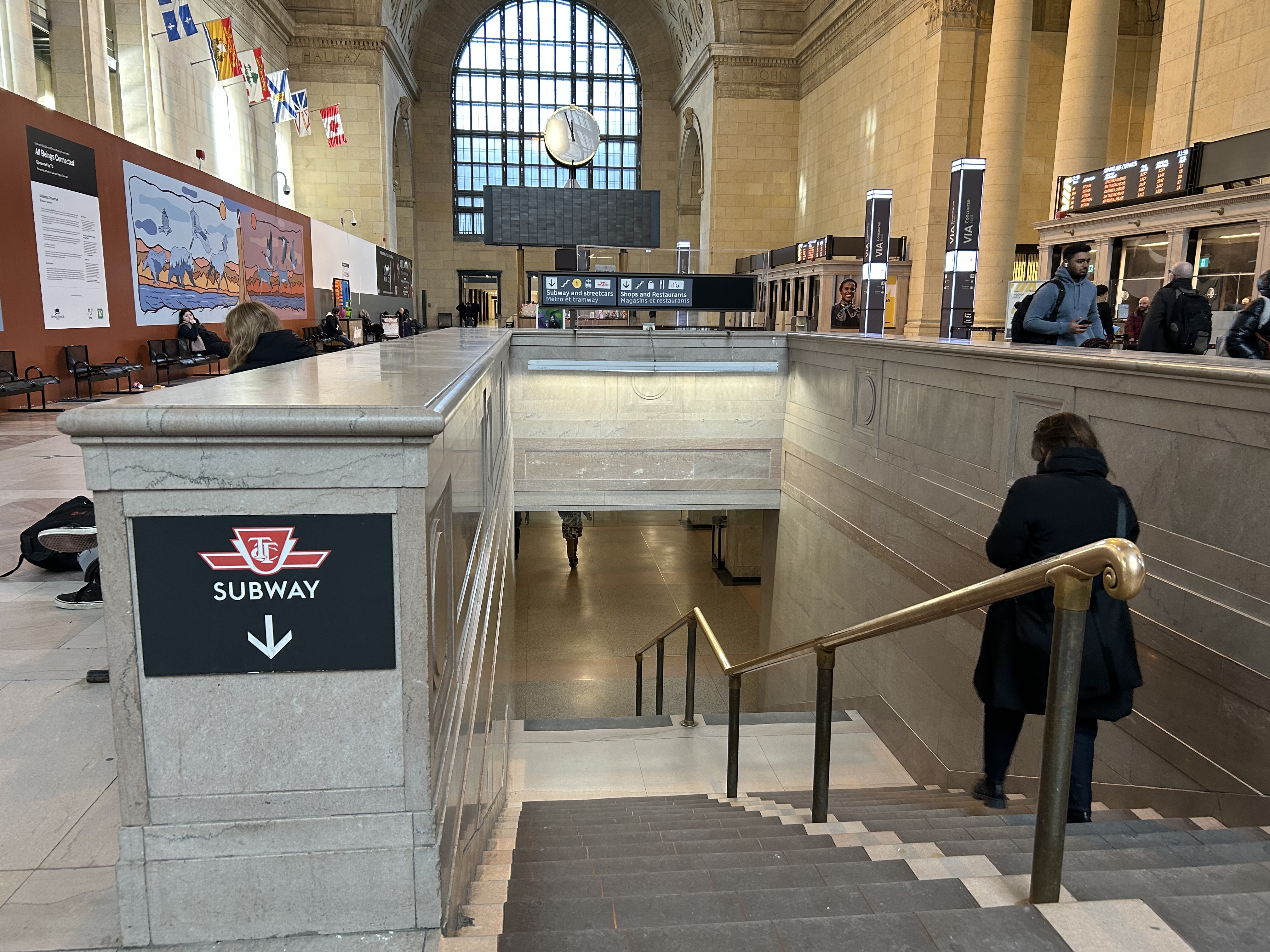
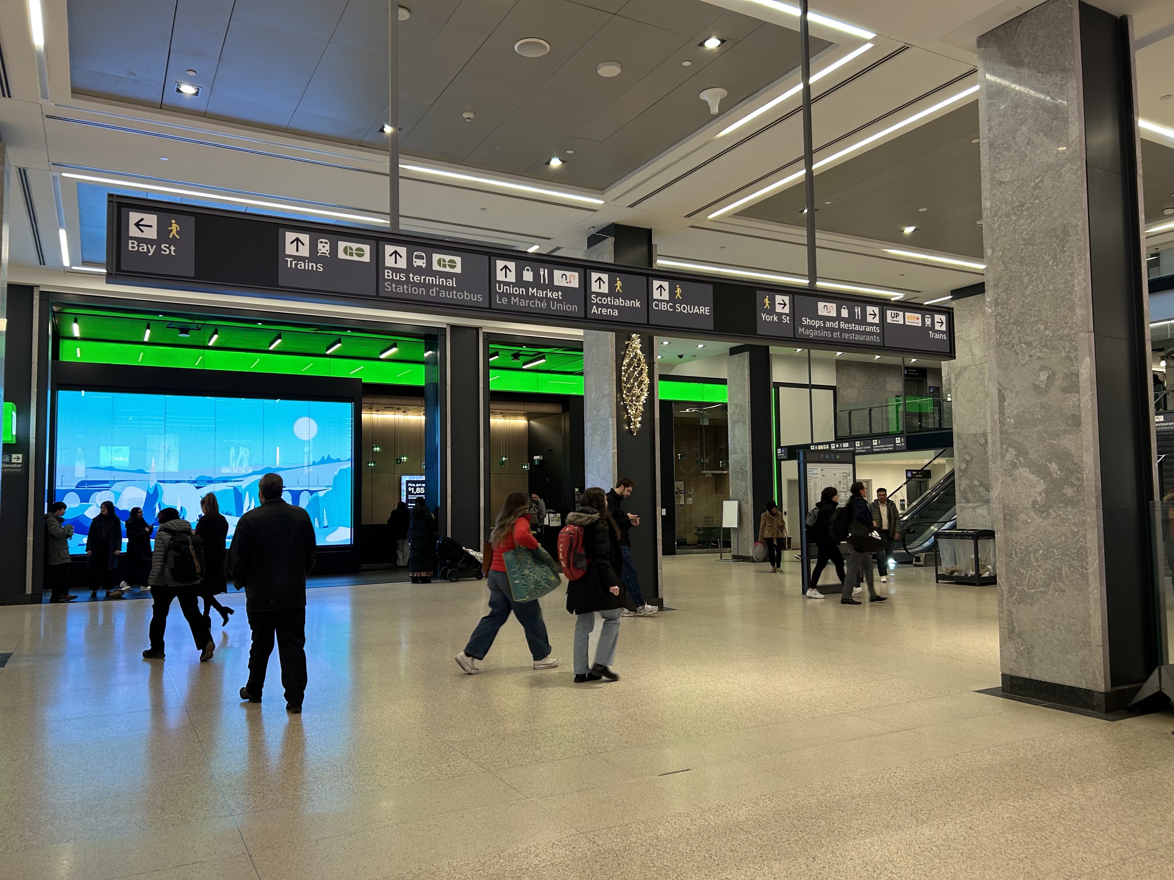
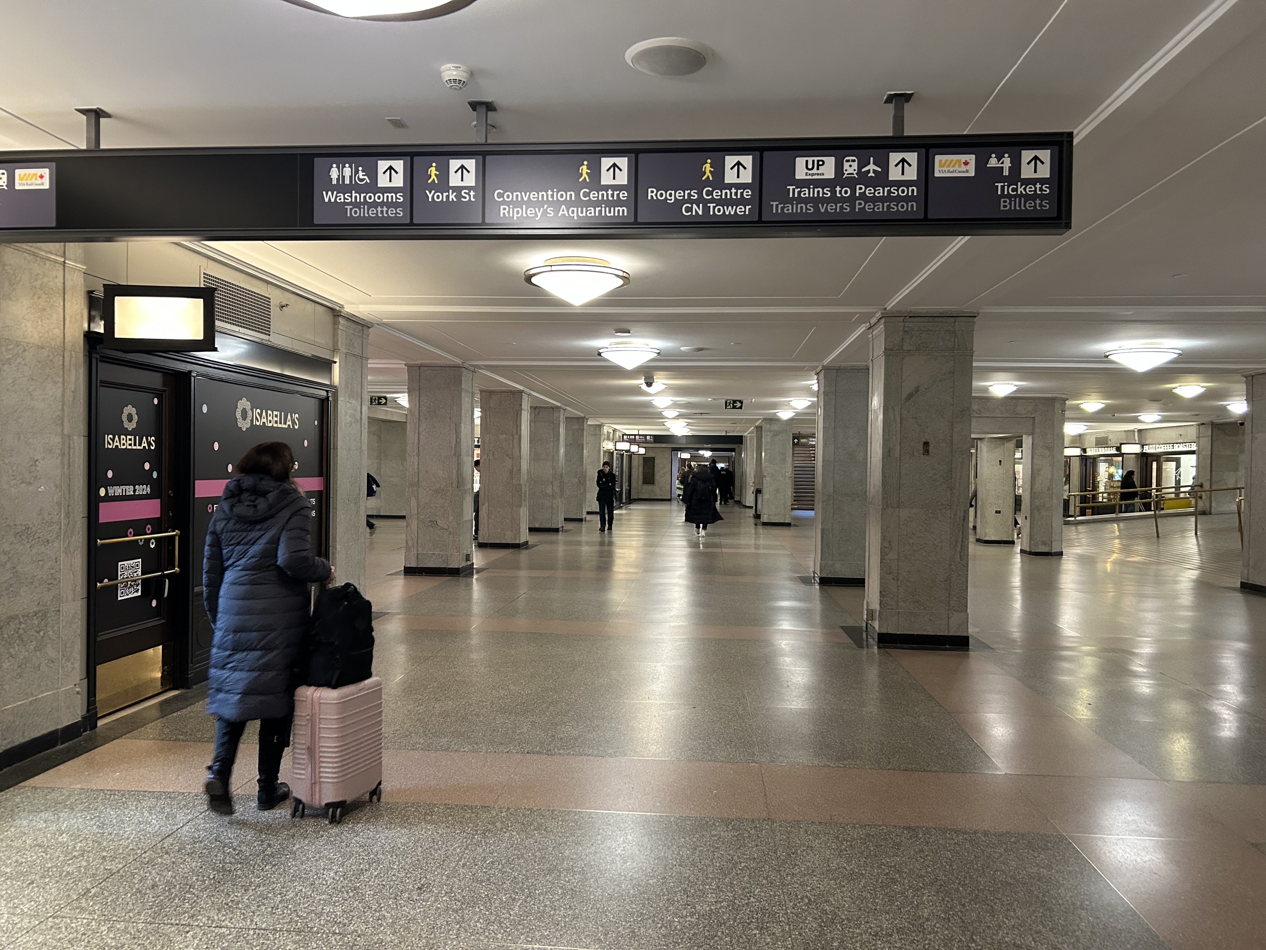
The view after entering the Union Station complex from the TTC subway. The overhead sign shows the way to GO trains, the bus terminal, the Union Market shopping area, Scotiabank Arena, CIBC Square (an office building), York Street, more shops and restaurants, and VIA and UP Express trains.
Imagine entering Union Station from the adjacent TTC subway station with a wheeled device or a mobility aid. There is a large concourse with signs leading forward towards the GO Transit York Concourse along with Scotiabank Arena, the bus terminal, and Union Station shops and food kiosks. To the left is Bay Street, and to the right are a set of escalators and stairs leading up towards VIA Rail and UP Express trains. Behind the stairs and escalators is a single elevator, hidden away.
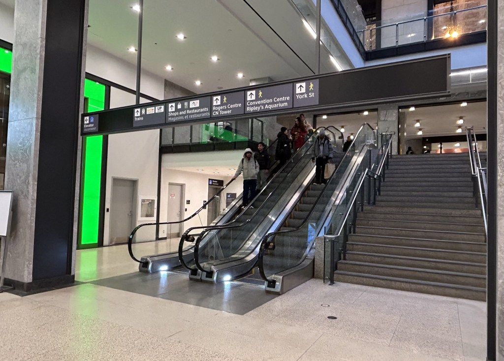
To the right is a set of escalators, stairs, and hidden behind, a poorly marked single elevator.These lead towards UP Express and VIA trains, York Street, and attractions such as the CN Tower, the Convention Centre, and Rogers Centre.
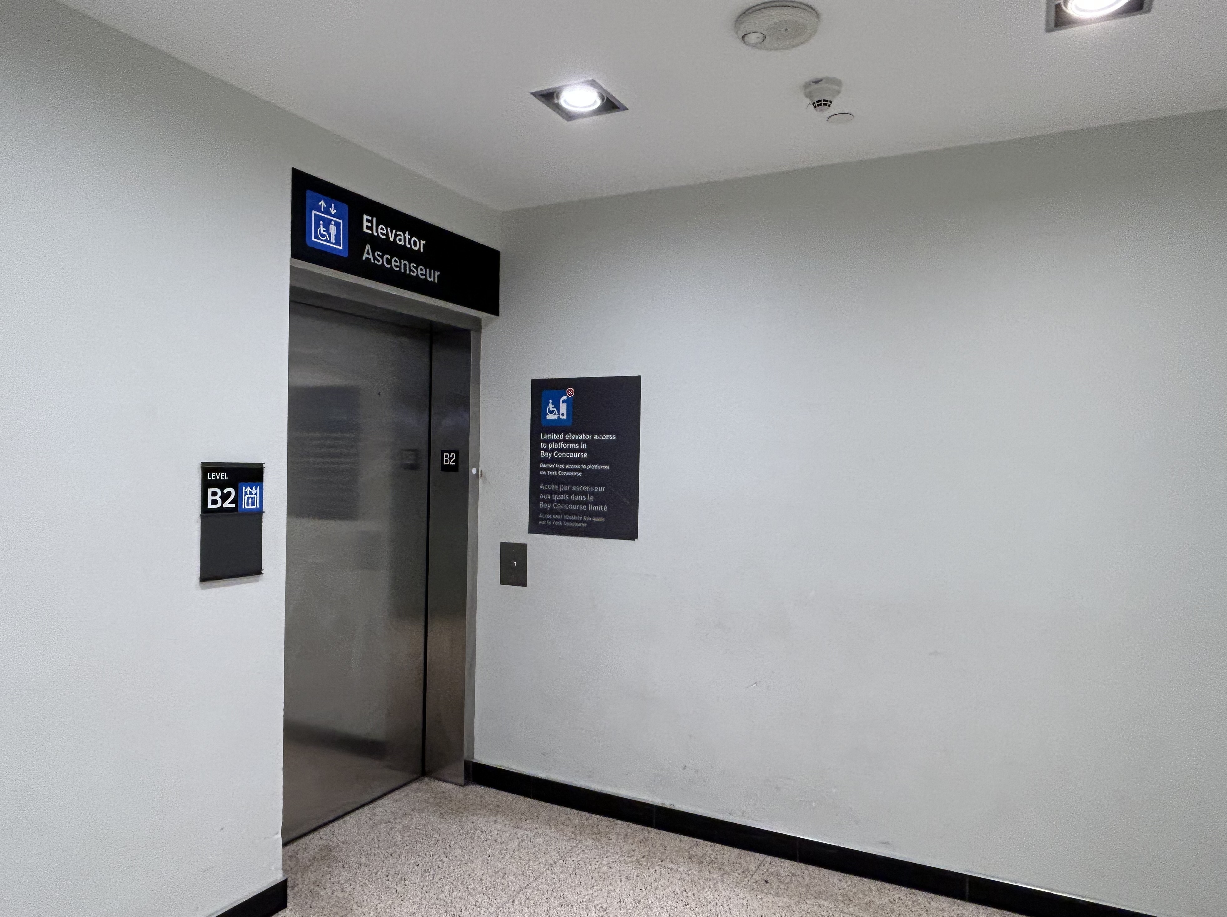
The elevator provides no information other than a sign that indicates that this is, in fact, an elevator, and this is the B2 level. This is a single, small elevator, which operates slowly.
The elevator at the B2 (subway) level
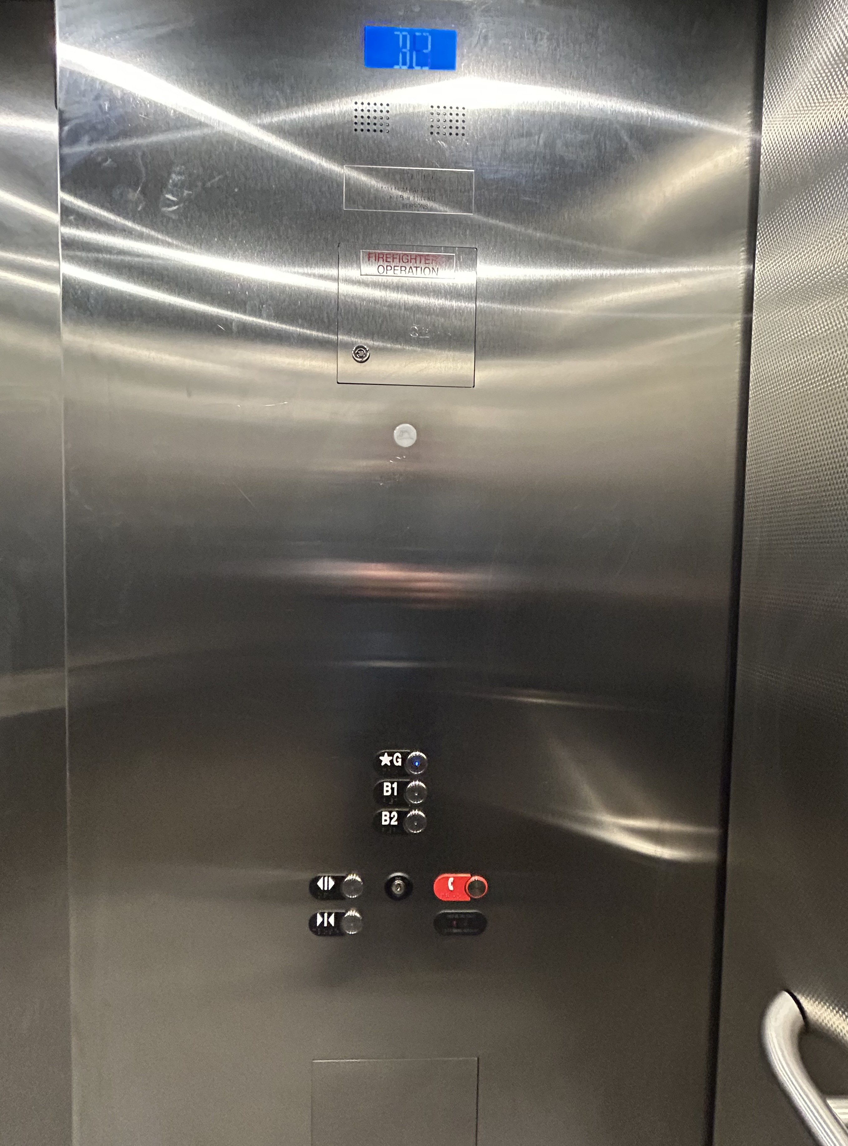
Once inside the elevator, there is no information other than buttons marked “G”, “B1”, and “B2”. There is nothing to tell the elevator user what is accessible from each floor.
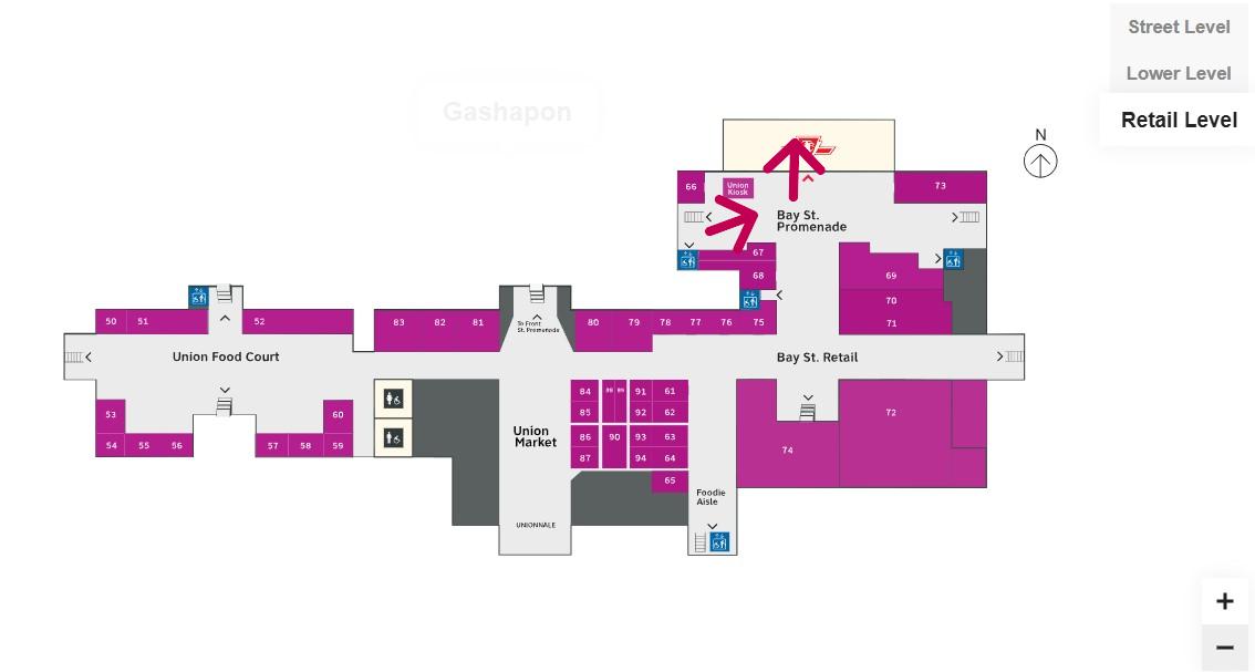
Confusingly, the official Union Station map directory calls the three levels “Street Level” (G, the Heritage structure including the Great Hall, West and East Wings, along with the path towards UP Express and the Skywalk), “Lower Level” (B1, the GO York and Bay Concourses, the concourse beneath the Great Hall, and the VIA departure area) and “Retail Level” (B2, including the food court, food hall, and connections to the subway). In the elevators, the audio prompts only mention the three level names.
Inside the elevators, there is no indication what each level is, or where they lead to — the buttons and empty spaces beside them just show G, B1, and B2 levels
At G level, which includes the Great Hall, VIA Rail departures and business class lounge, and the passage west towards UP Express trains and the Skywalk to the CN Tower and Rogers Centre, the elevator is also hidden behind a wall.
The only elevator connecting the Great Hall, the lower concourse, and the subway level is hidden, with tiny signage directing travelers to it
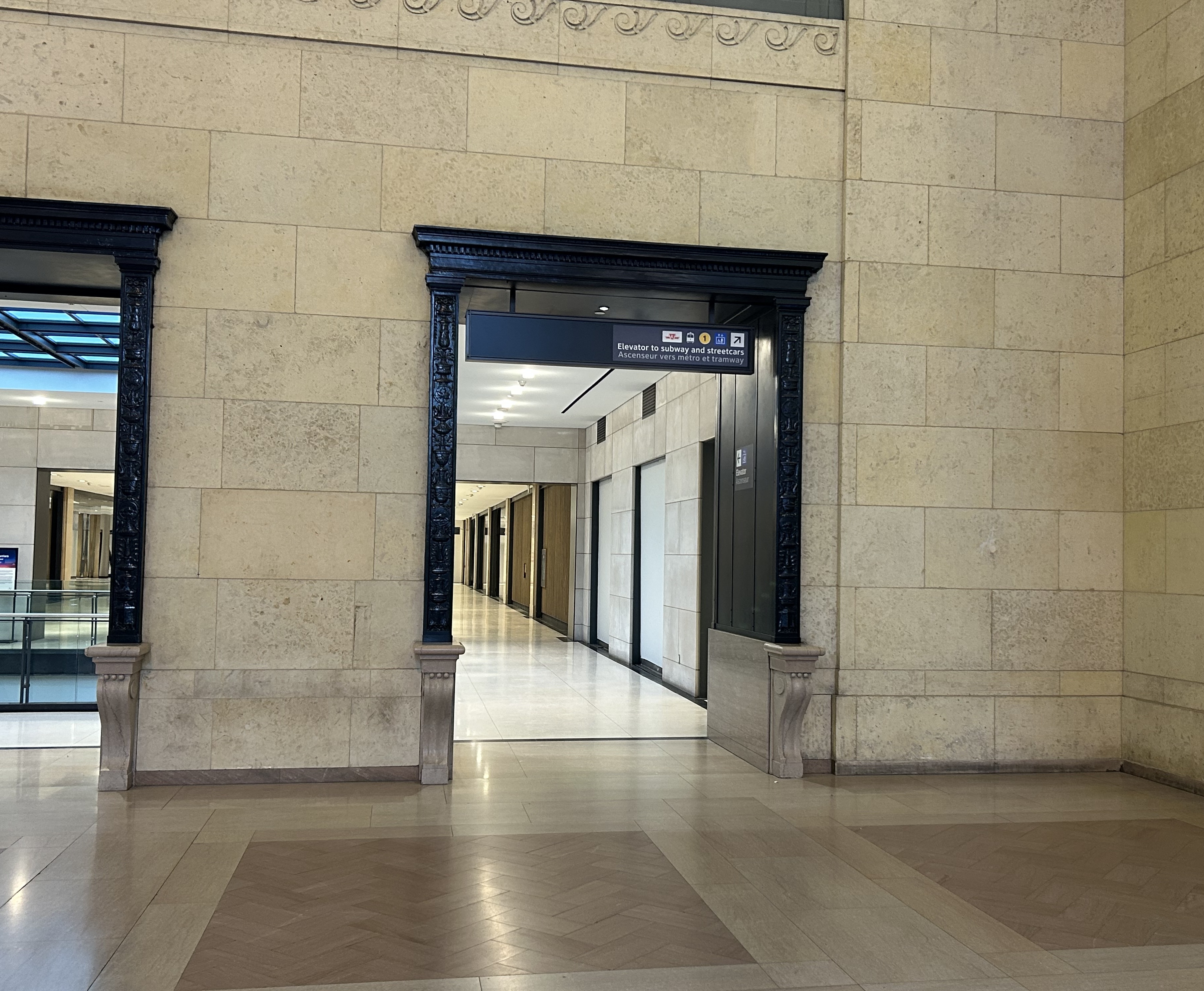
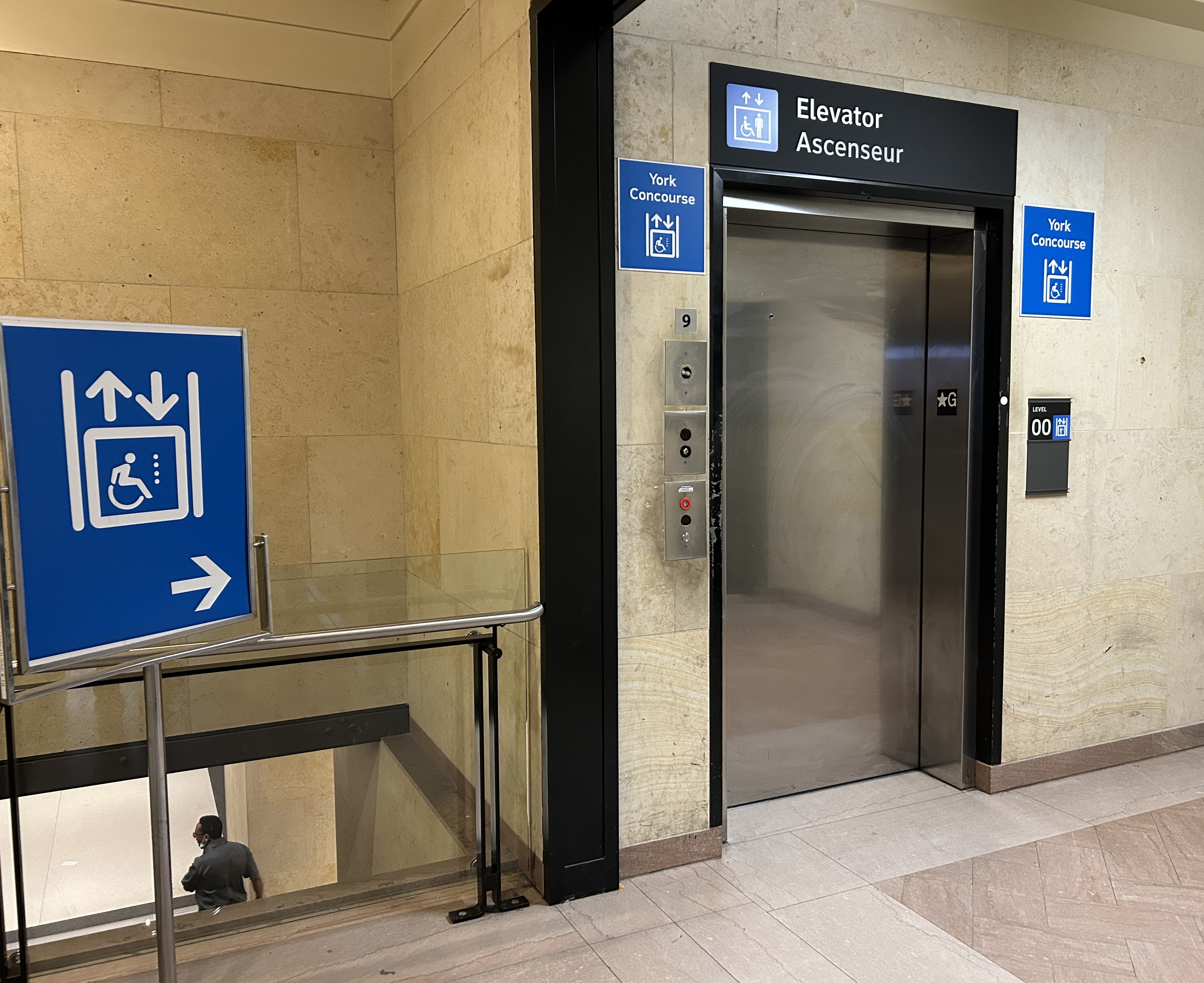
On the west side of The Great Hall, there is also an elevator, beside the stairway down to the GO Transit York Concourse. This elevator does not serve level B2.
York Concourse elevator, on the west side of Union Station’s Great Hall
If the traveler was only connecting from subway to UP Express with a heavy bag, and not using a mobility device, they might decide to take an escalator from the subway B2 level to the B1 level, the lower Union Station concourse originally intended as an arrivals area for intercity trains. However, there is no elevator or upwards escalator to be seen.
Looking west in the lower concourse, towards York Street and UP Express trains
If one knew Union Station well, they could make a lengthy detour through the ramps in the VIA Rail area to get to the Great Hall or go around through the GO York Concourse to reach the elevator or up escalator to the Great Hall. But these routes are not marked from the lower concourse area.
To show how difficult it can be to navigate the station while using a wheeled device (be it a wheelchair, stroller, or wheeled luggage), I shot this video showing how a first-time visitor getting off an UP Express train from Union Station would try to find the TTC subway entrance.
Video depicting 9-minute trip at a normal walking speed between the UP Express area and TTC subway station entrance, using first available elevators each time.
At no point was there any visible signage showing the most direct route for someone requiring a barrier-free path from UP Express to the subway. The maps below show the route I took:
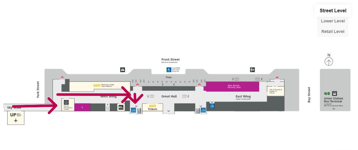
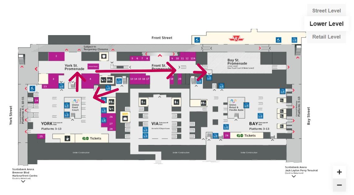
Route from UP Express to the Great Hall and York Concourse Elevator (Street Level, or G). Arrows are added to mark the route I took in the video.Path through York Concourse, lower Union Station concourse (Front St. Promenade) – the B1 Level, and to the second elevator to the Bay St. Promenade (subway level). Arrows are added to mark the route I took in the video.Last part of the trip on the Retail Level (B2) to the subway station entrance. Arrows are added to mark the route I took in the video.
Whenever I travel through an international airport — Toronto Pearson is a good example — I never have to think too hard about where the accessible routes are. Escalators are easy to find. There are banks of two or three large elevators in strategic locations on the ground side of airports, connecting departure and arrival areas, as well as ground transportation facilities. As Canada’s busiest transport hub — busier than Toronto Pearson Airport even — Union Station’s elevators and escalators should be plentiful and easy to find.
I am aware that there are particular challenges at Toronto Union Station — the City of Toronto controls only the common areas, such as the Great Hall, the retail areas, and the main entrances. Metrolinx, the agency responsible for GO Transit and UP Express, controls the York and Bay Concourses, as well as the UP Express station area. VIA Rail maintains its departures area. There are also heritage elements that need to remain intact, such as the Great Hall. But these issues of ownership and heritage preservation do not excuse the difficulty of getting around with a mobility device or even a wheeled bag.
Why weren’t multiple elevators installed connecting all three levels, to improve capacity, speed, and provide redundancy in the case of an elevator outage? Why are there not easy-to-find elevators in the West Wing near the UP Express area?
Judging by the condition of the signature Great Hall itself, there is work yet to be done before Union Station is fully restored to its 1920s grandeur. It should not be too hard to improve accessibility and wayfinding as well. Not just for Torontonians, but for international travelers too.
The Great Hall floor is still cracked and patched, with electrical tape covering some of the damaged sections
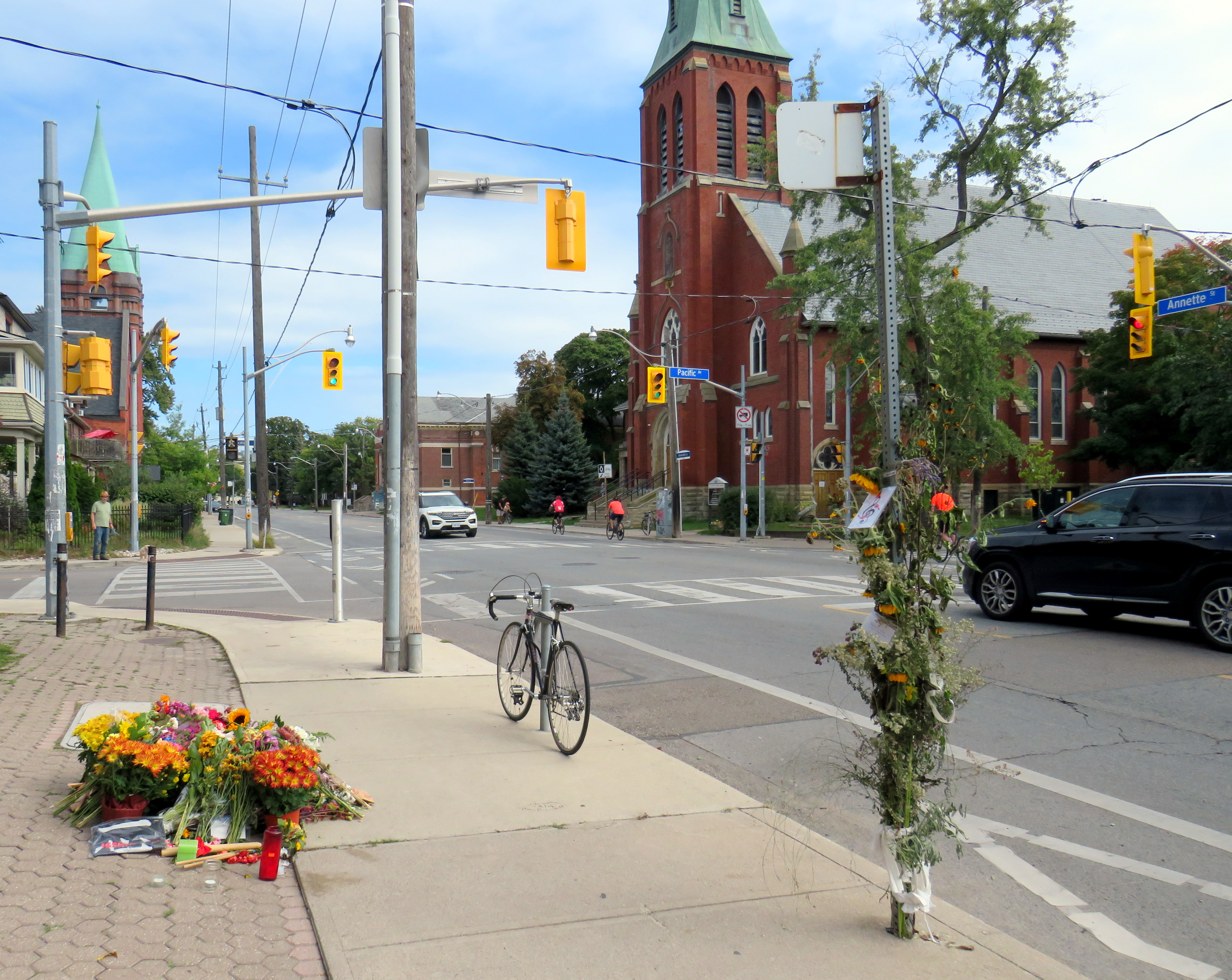
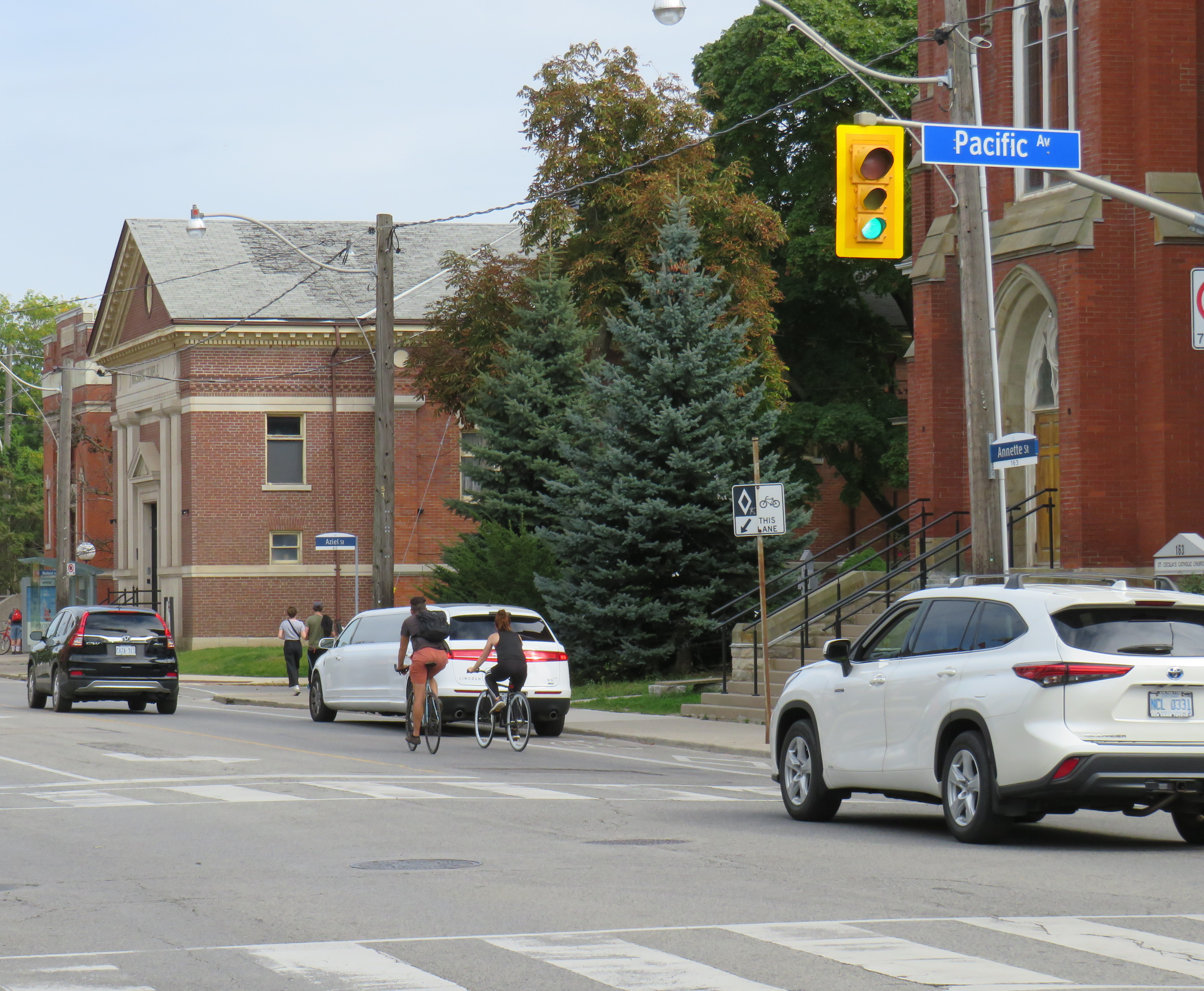
On Monday, September 23 at 8:06 PM, the driver of a 2024 Hyundai Elantra sedan travelled north on Pacific Avenue. The driver of a 2017 Hyundai Tucson crossover SUV drove west Annette Street. The two vehicles collided in the intersection with enough force that the Tucson continued into the sidewalk on the northwest corner, striking two pedestrians. A man, aged 50, was injured and taken to hospital. Julia Cleveland, 46, died at the scene.
As of Thursday, October 3, charges have yet to be laid.
Looking west on Annette Street towards Pacific Avenue
On Saturday, September 29, I paid a visit to Annette and Pacific. A roadside memorial of flowers, cards, and tributes were laid next to the sidewalk where she and a fellow pedestrian were struck. I also took note of the streetscape, the surroundings, and driver behaviour on a Saturday afternoon.
While at the intersection, I observed many examples of distracted, aggressive and inconsiderate driving, as the video compilation depicts. Drivers intentionally drove through stale amber and solid red lights, blocked crosswalks, and swerved around slower vehicles. These motorist behaviours are commonplace.
Video shows driver behaviour at Annette Street and Pacific Avenue
I also noted many pedestrians and cyclists. There’s a No Frills grocery store on Pacific Avenue between Annette and Dundas. Two blocks east, there’s a Toronto Public Library branch. There were several families with young children, as well as older pedestrians.
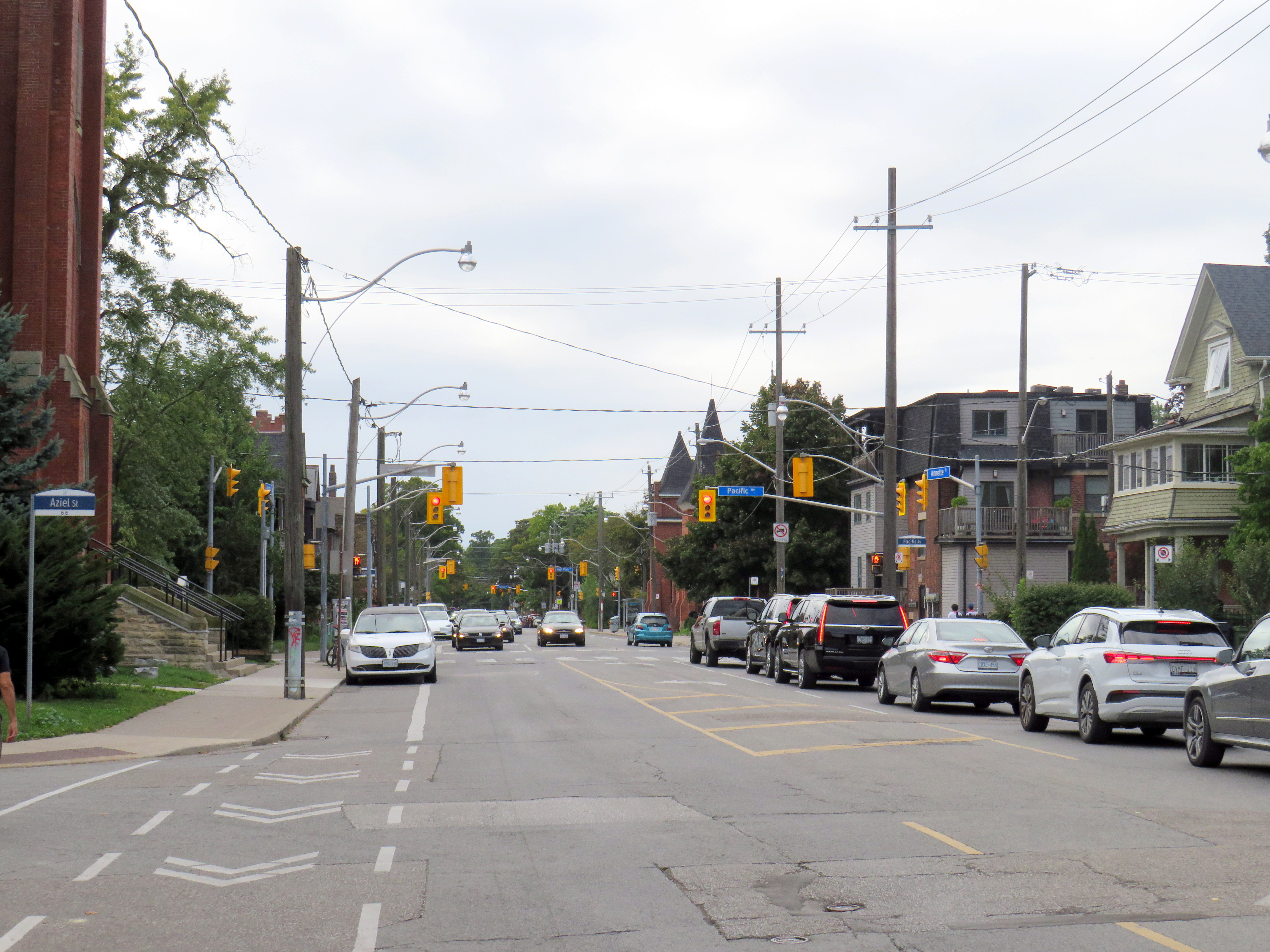
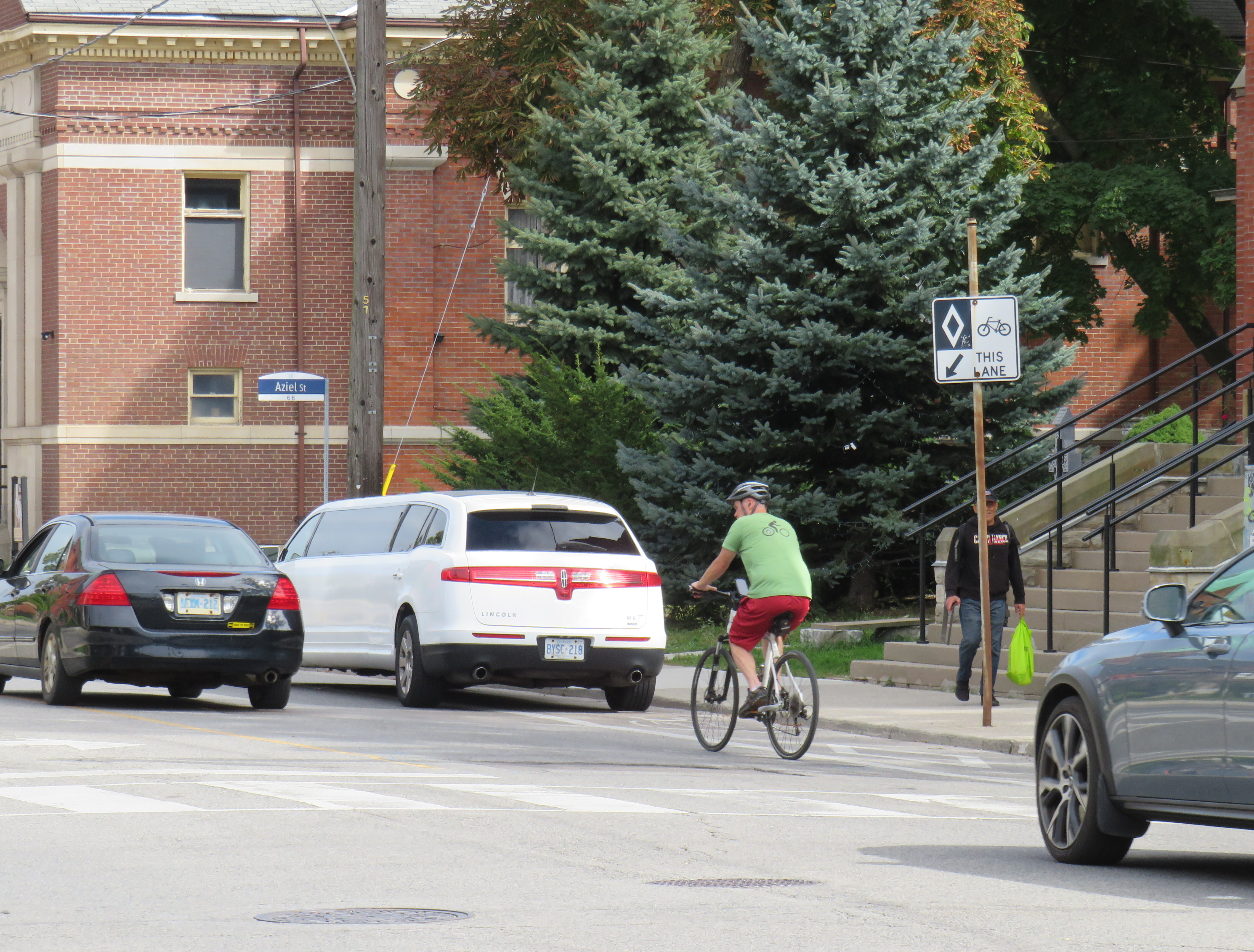
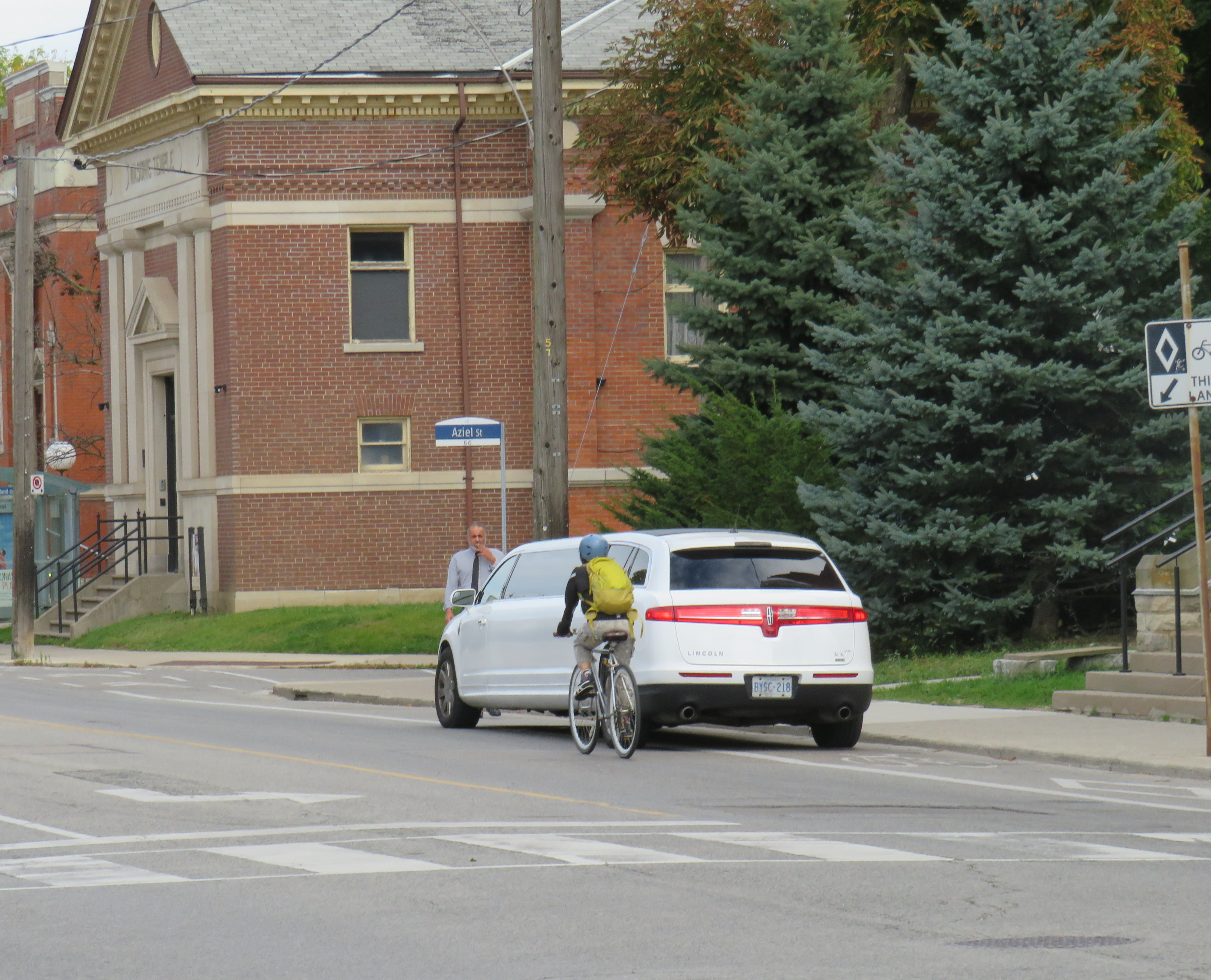
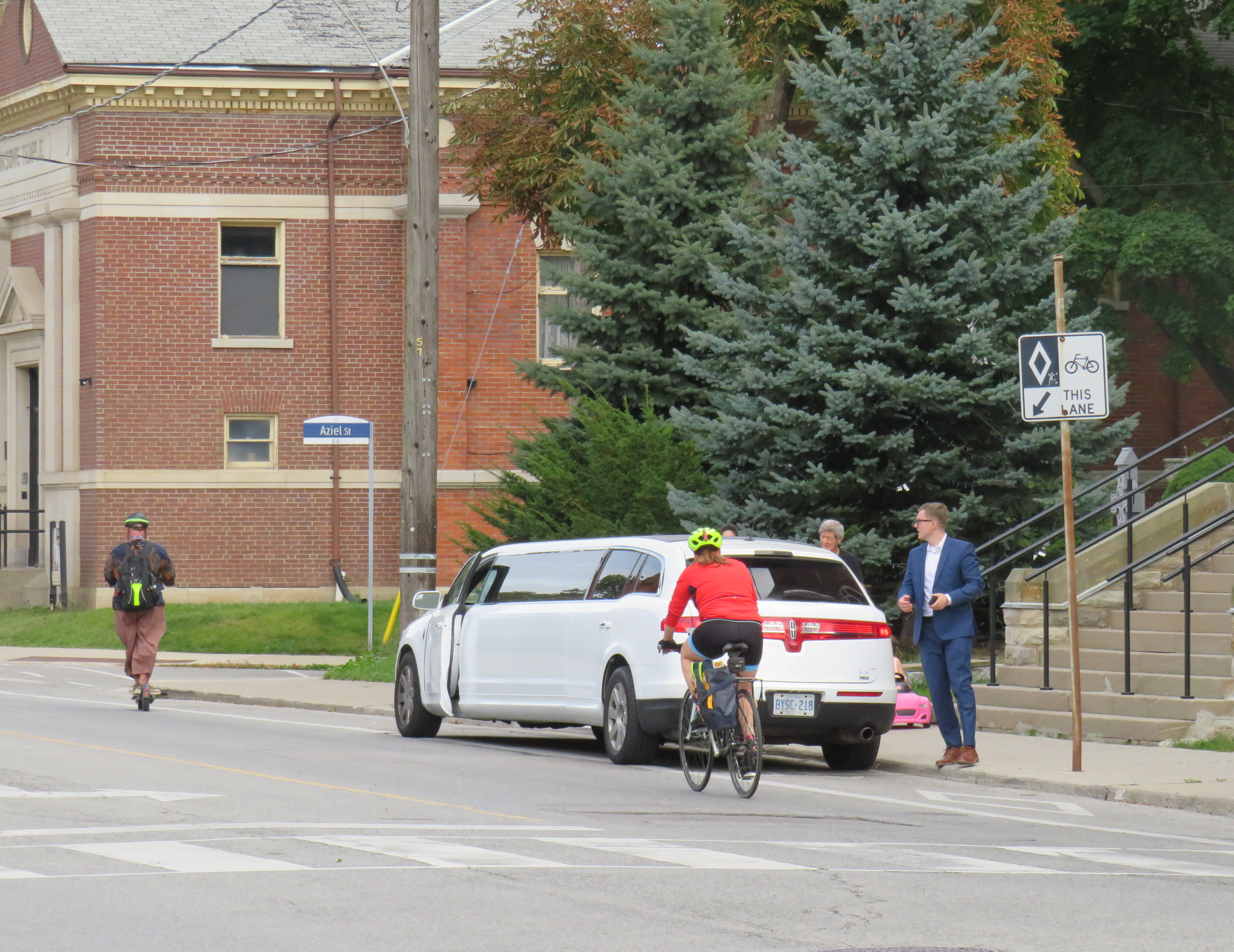
In 2008, Annette Street was reconfigured from a four-lane cross-section to include bike lanes and centre left turn lanes. Though it is a busy east-west cycling route, connecting to bike lanes on Dupont Street and Runnymede Road, the lanes are unprotected and are only marked with solid white lines and signage. The limited protection offered to cyclists was made clear when a stretch Lincoln limousine pulled out front of St. Cecilia’s Catholic Church and idled in the bike lane for over 30 minutes. Though the driver was likely waiting out front for a wedding party to emerge, I noted at least two dozen cyclists forced to merge into traffic to get around it.
Cyclists merging around a limo idling in the unprotected bike lane
The intersection itself offers minimal protection to pedestrians. Sidewalks are flush against the roadway, with very shallow curbs. There are unnecessarily wide turning radiuses at intersections. On the northwest corner of Pacific and Annette, there are metal bollards, but they are positioned to protect the small apartment building, not the sidewalk itself.
Looking east on Annette from Pacific Avenue. On the right is St. Cecilia’s Catholic church, beyond is a masonic lodge and a Toronto Public Library branch
Annette and Dupont Streets make up a useful bypass around traffic on Bloor Street to the south. There are three blocks between Pacific Avenue and the first traffic signals to the east, at Keele Street. To the west, however, there are traffic signals at the next three intersections: at High Park Avenue, Quebec Avenue, and Clendenan Avenue. Motorists might be tempted to speed through amber and red signals. Without better protection — protected bike lanes, for example, pedestrians and cyclists are especially vulnerable. Despite the 2008 road diet, the roadway has not been significantly altered.
A few days later, on Wednesday, October 2, there were two more collisions in which drivers struck pedestrians at signalized intersections, at Avenue Road and Davenport Road in Midtown Toronto, and at Islington Avenue and Finchley Road/Odell Avenue in central Etobicoke.
At Avenue and Davenport Roads, a pedestrian was struck when the drivers of three cars collided. One vehicle, a Mercedes-Benz SUV, stopped on the sidewalk after hitting a concrete pole.
Pedestrian seriously injured at Avenue Road and Davenport. Road safety improvements on Avenue Road are scheduled to start soon, which unfortunately was not soon enough to prevent another injury. Via@ARSCSafetyhttps://t.co/CspQr8isoZpic.twitter.com/MqppOVd2PV
In Etobicoke, a family of five were struck by a left-turning motorist turning from Finchley Road south onto Islington Avenue. The driver, a 77-year old woman likely visually impaired by the late afternoon sun, hit the family; the entire family — including a one-month old baby — were sent to hospital with serious injuries, while the mother was sent to a trauma centre with life-threatening injuries. Traffic signals were installed there in 2022 to help pedestrians cross Islington Avenue. Despite the new signals, locals continue to complain of drivers rushing the lights.
The problem on Toronto’s roads isn’t simply an engineering one, though protected bike lanes and physical traffic calming measures on Annette Street likely would have prevented Julia Cleveland’s death. Aggressive driving, including speeding, sudden lane changes, and red light running, along with distracted driving is increasingly a problem in Toronto and across the region. Engineering changes can help curb speeds, but there needs to be more done to rein in dangerous behaviour. That means more automated enforcement (red light and speed cameras) but also active enforcement to curb dangerous driving.
Returning to Downtown Pittsburgh across the Roberto Clemente Bridge after the game and a fireworks display
Earlier in June, a friend and I took a weekend road trip to Pittsburgh, a five-hour drive southwest of Toronto. On our first night there, we took in a ballgame at PNC Park, where the hometown Pirates hosted the Minnesota Twins.
Though I do not follow the Pirates (who are in the National League) nor the Twins (who are in the AL Central), I was excited to take in a ballgame in Pittsburgh because I have heard about the park’s intimate confines, the great view of the Pittsburgh skyline, and the fireworks that follow certain Friday and Saturday night games. PNC Park lived up to the hype.
Among the major North American sports leagues, Major League Baseball has the most significant differences between venues. Unlike hockey, basketball, soccer, and football fields, the dimensions of each playing surface vary considerably, as does the architecture. PNC Park was built in the retro-classic style similar to Baltimore’s Camden Yards; it opened in 2001. When the naming rights for the new publicly-financed stadium was purchased by local bank PNC, the city renamed the adjacent 6th Avenue Bridge for beloved Pirates player Roberto Clemente, a Hall of Famer and a humanitarian. That bridge is closed before and after each game to motor vehicles so that fans can walk and bike across the Allegheny River to and from downtown.
Statue of Roberto Clemente located between the stadium and the bridge renamed in his honour. No statues of cable tycoons can be found here.
The skyline view from behind home plate is spectacular, showcasing the most iconic buildings and some of the many bridges crossing the three rivers in the downtown area. With lots of washrooms, a wide concourse, and plenty of food and drink concessions, the stadium felt intimate, yet uncrowded. Lineups were always short, and where play wasn’t visible (such as in the washrooms), speakers played the radio broadcast. Ushers were very friendly and helpful as well.
View from up behind home plate
The game was followed by a 10-minute fireworks display, with the rockets launched off a barge in the Allegheny River.
Finale of fireworks show
Though transit access is quite good — there is a station one block away on Pittsburgh LRT’s North Shore extension — many fans walked part of the way home. Downtown parking garages — built for office commuters — provide much of the parking demand, so there are few surface parking spaces surrounding the stadium. Even the football stadium, a few blocks to the west, is mostly served by parking garages and another LRT station. Hotels, restaurants, museums, and apartments neighbour the two North Shore stadiums.
Walkability and transit access are the key to fostering a great fan experience. Walkable stadiums promote safe, accessible, and sustainable travel to and from sports venues, and help support local businesses. Downtown locations have the advantage of having better transit access, existing parking facilities, and in the case of Pittsburgh (or Detroit, or Minneapolis), a downtown ballpark can be a point of civic pride, showing off the city to its inhabitants, and to a much larger audience.
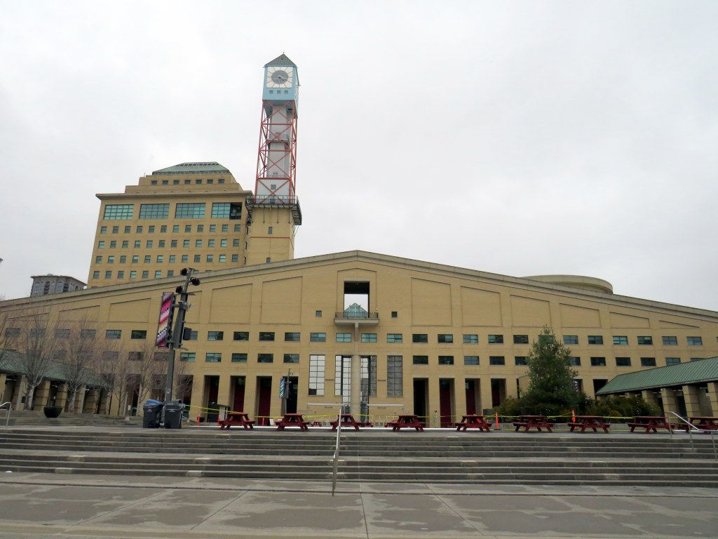
Mississauga City Hall, one of the most walkable municipal buildings in Ontario
In late March 2024, with a streak of mild, sunny days, I was eager to get outside and walk. As I have long been interested in local politics and planning issues, public transit, active transportation (especially walking advocacy), I thought I would try to get to every city, town, and township hall in the Greater Toronto and Hamilton Area (GTHA) without a car.
This was a fun project, even if there were times I felt really frustrated at times by poor transit and long hikes. The highlight of my quest was a tour of Mississauga City Hall from Councillor Joe Horneck. Mississauga’s civic centre is one of Ontario’s most iconic — and walkable — government buildings.
Mississauga Council Chambers
Of the three levels of government (federal, provincial, municipal), the municipal level has the most impact on the day-to-day lives of most Canadians; it is also the closest level of government to all. Residents can depute at committee meetings, get meetings with their local councillor and city staff, and obtain building permits, marriage licenses, or pay bills at city and town halls. Therefore, they should be as accessible as possible, especially to those without cars.
Only one GTHA town hall (Caledon) was completely inaccessible without a car, though several other town halls required long walks from the nearest transit stop, making them inaccessible to some residents. But I could get to Brock Township, the least-populated and most-rural municipality in the GTHA, thanks to Durham Region Transit’s On-Demand service, though I had some difficulty there.
The complete list of GTHA city and town halls, along with photographs and a map can be accessed here.
On Friday, May 10, Mississauga City Councillor and mayoral candidate Dipika Damerla posted a message and video on Twitter/X, stating that “it will be up to the residents to decide on who best represents the vision of the Mississauga they want.” She followed that by saying that she “will not be silenced in my opposition to remove two lanes from Bloor Street and create more gridlock in Mississauga.”
It will be up to the residents to decide on who best represents the vision of the Mississauga they want.
In the video, she is standing on Bloor Street West at Yonge Street in the heart of Toronto’s Bloor-Yorkville business district, 16 kilometres east of the Mississauga border at Etobicoke Creek. Needless to say, this is a very different built environment than anywhere in Mississauga.
Toronto’s Bloor-Danforth bike route, which stretches from Danforth Avenue and Dawes Road on the east to Bloor Street West at Aberfoyle Crescent (near Islington Avenue) is very well used by cyclists, including commuters, couriers, and casual riders. There is also a subway paralleling the entire corridor. Behind Councillor Damerla, there is heavy traffic, but it is unfair to blame the bike lanes for this congestion. The vehicles are stopped at a red light at Yonge Street, one of the busiest intersections for pedestrians and cyclists in the city. There’s a dedicated scramble crossing at the intersection, which does reduce the green light time for traffic on Bloor, though it makes it safer for pedestrians, who outnumber all other road users there.
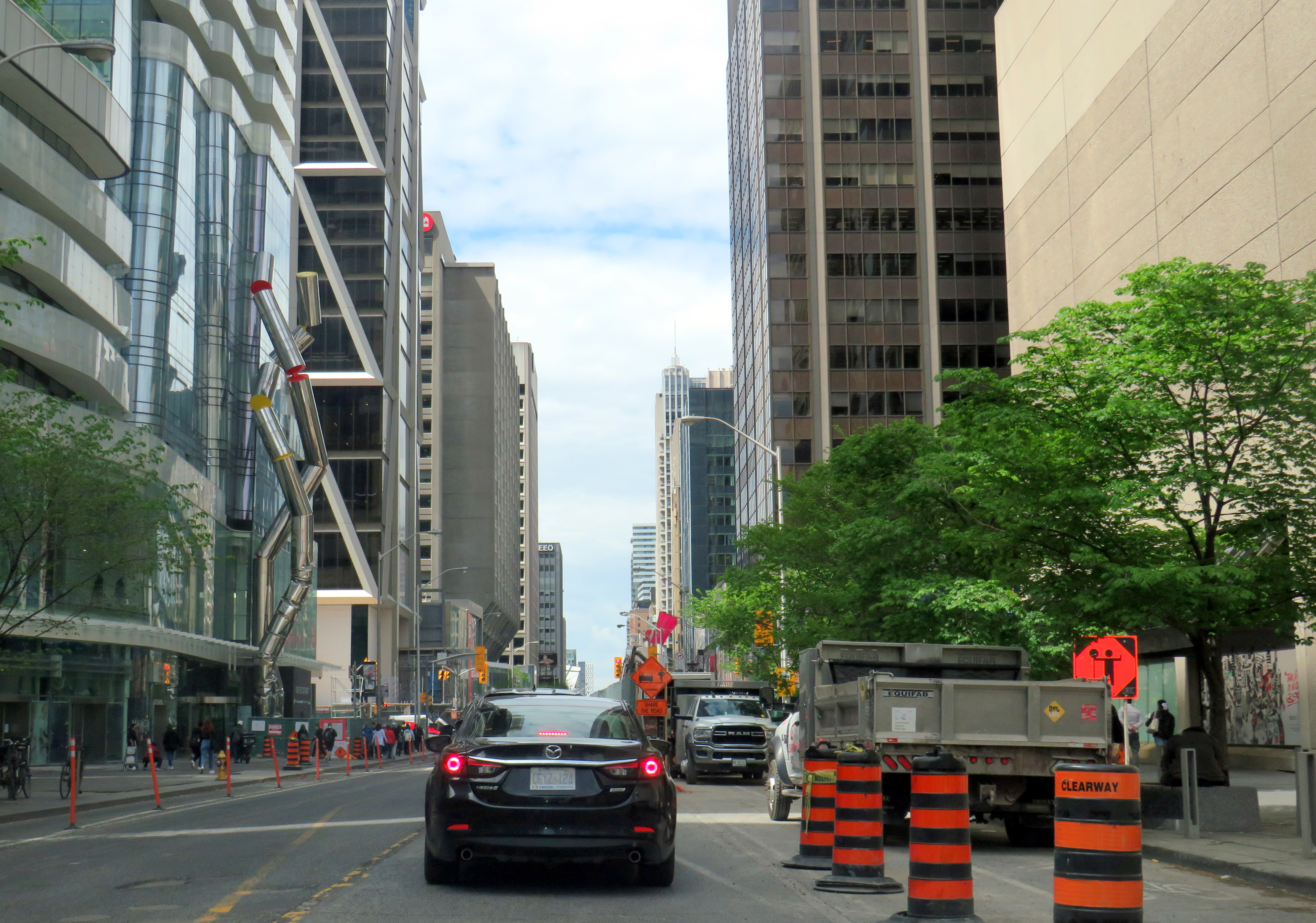
There is also considerable construction in and around the intersection. Work continues on the troubled “The One” condominium tower, blocking off some of the southwest Yonge-Bloor corner. Just east of Yonge, pedestrians, cyclists, and motorists are squeezed as the TTC works to expand the Bloor-Yonge Subway Station below.
Furthermore, before the bike lanes were installed, the curb lanes were used by stopped cars and delivery trucks; Bloor Street was never a traffic clearway, and it is a ridiculous argument that the bike lanes have caused congestion.
Construction on Bloor Street is the cause of some of the congestion in the area
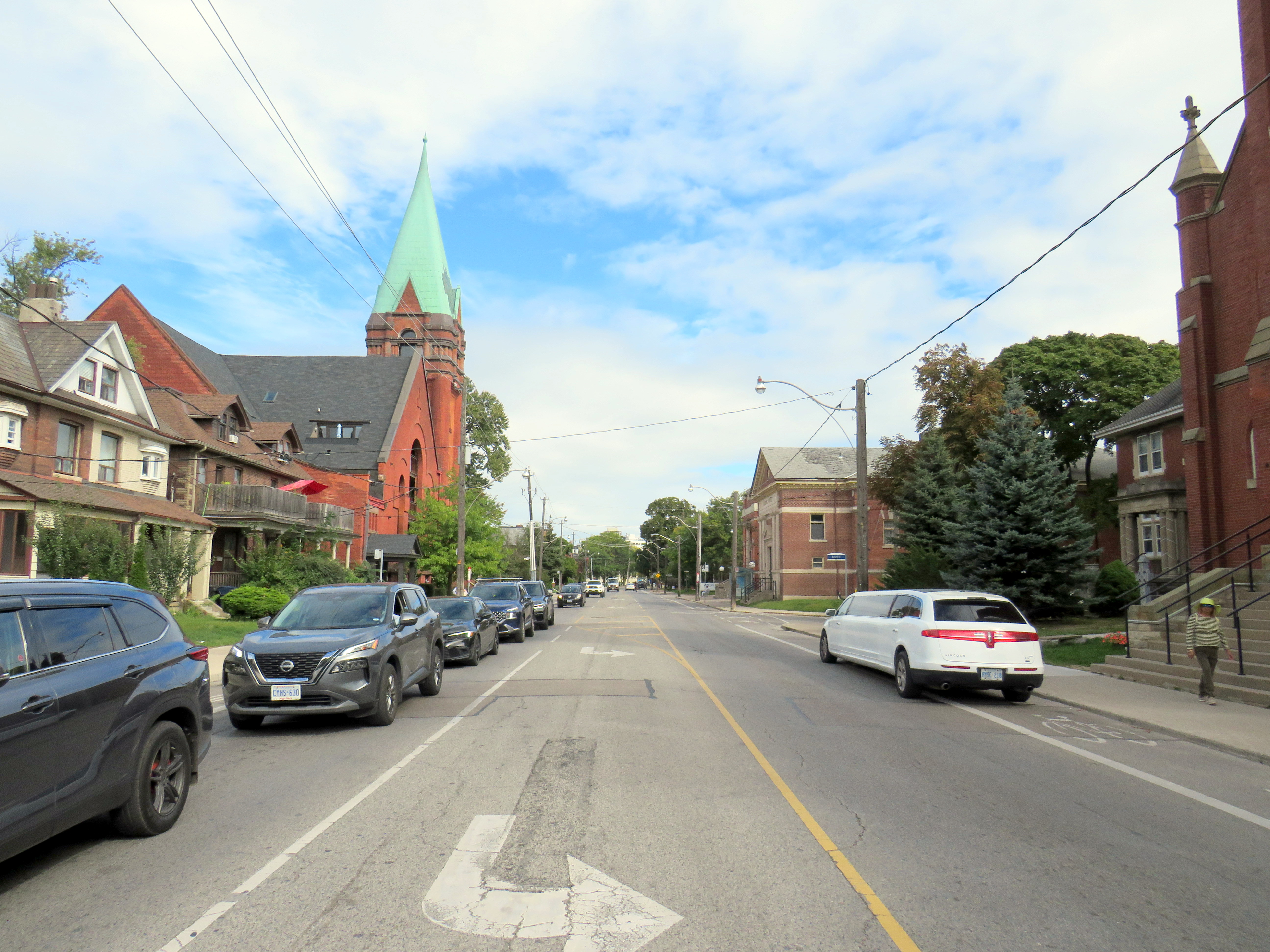
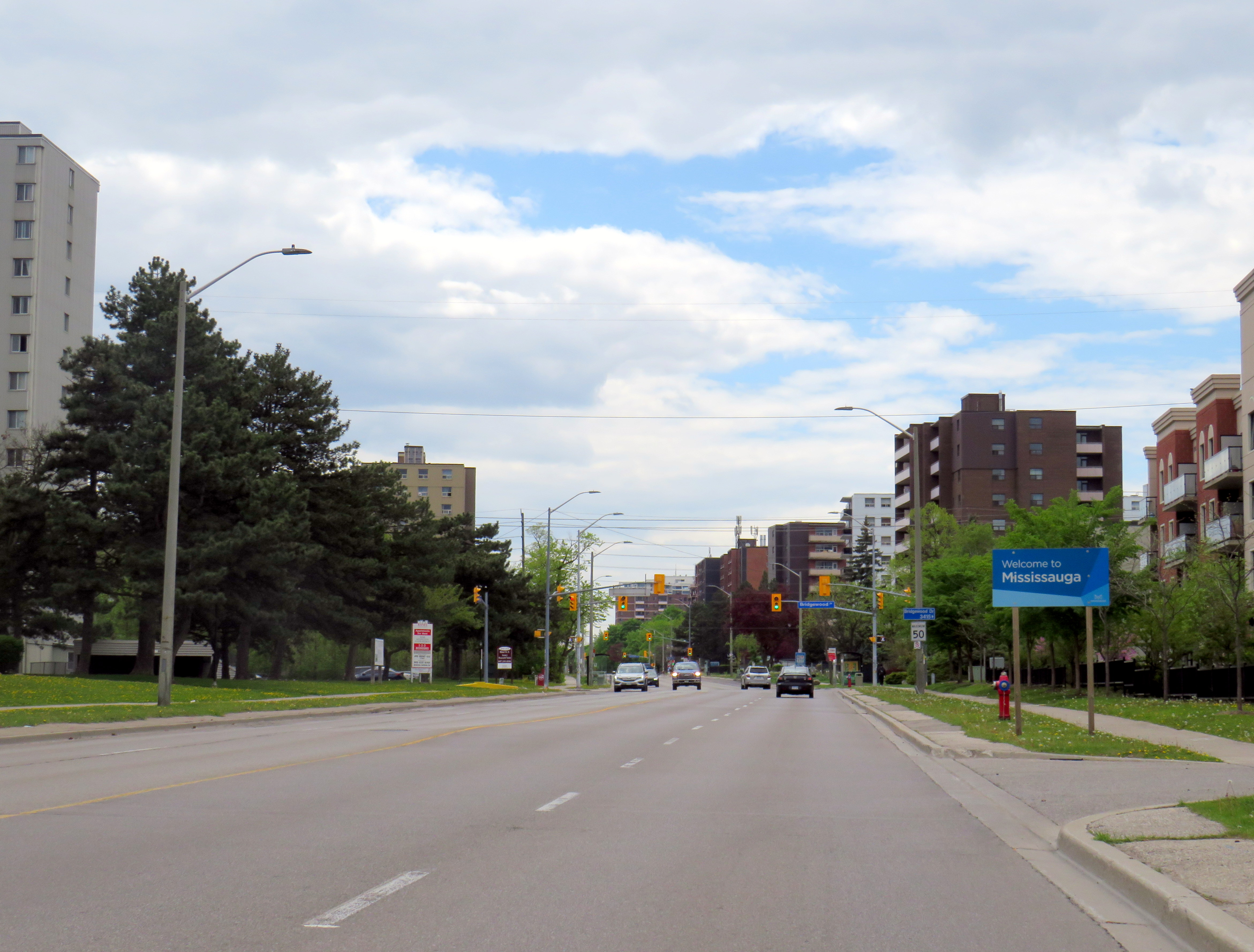
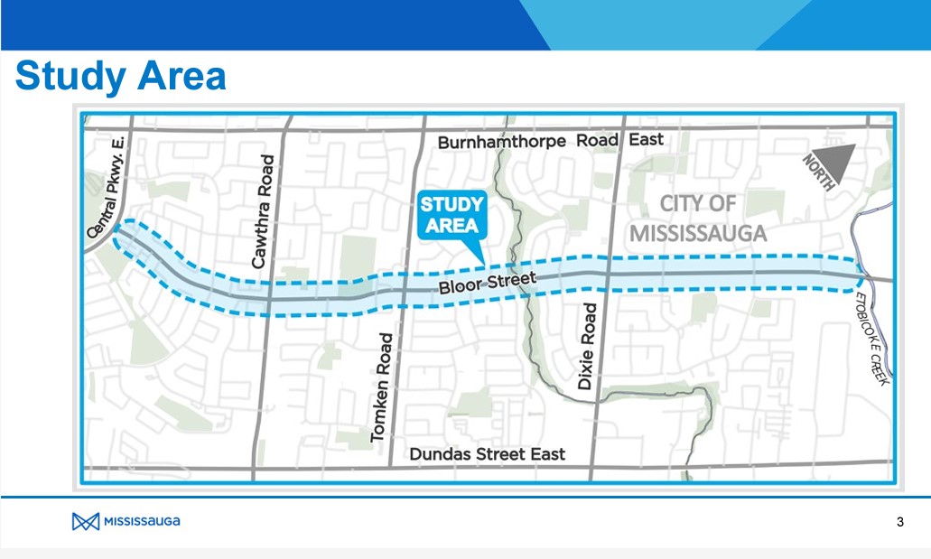
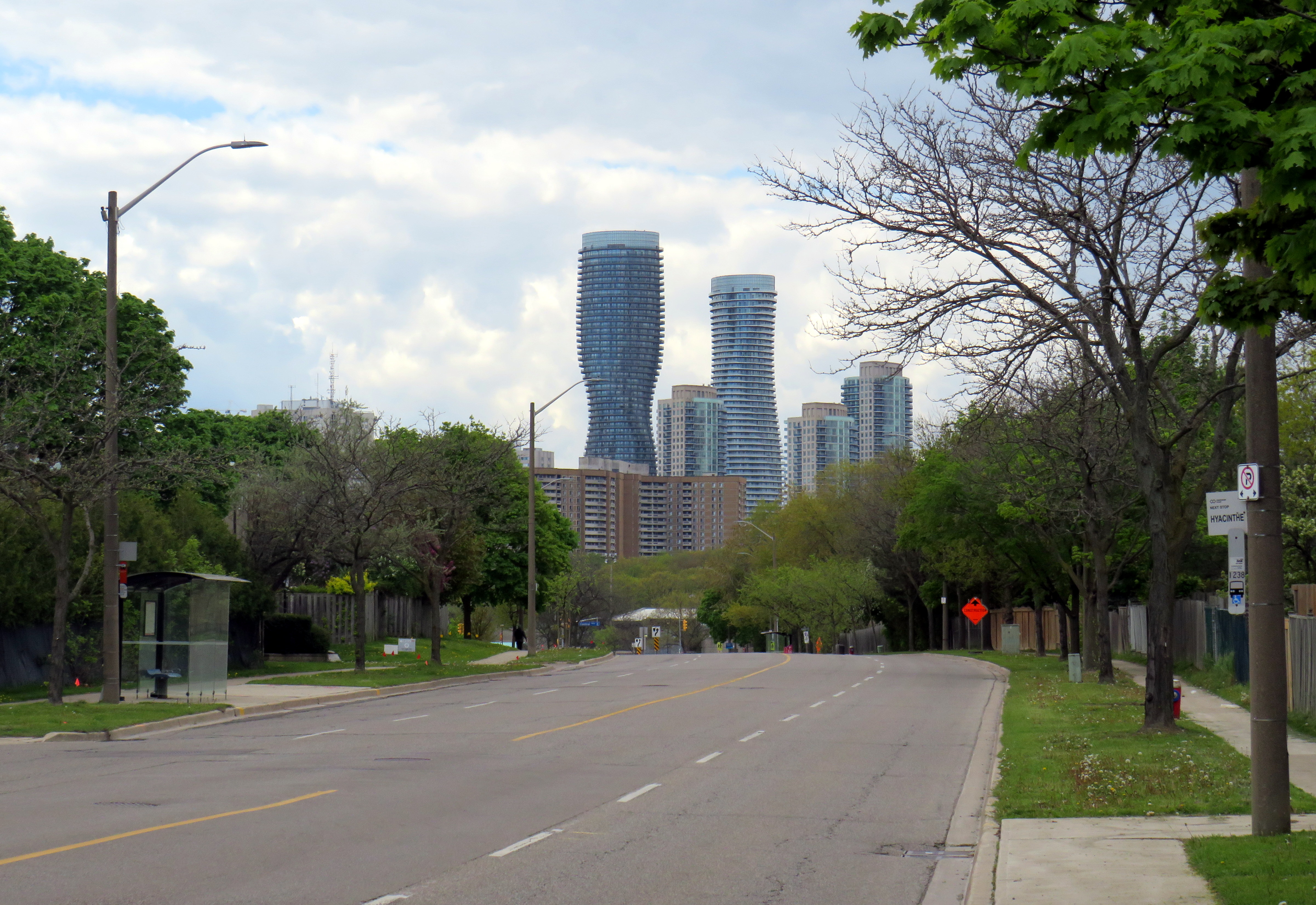
In Mississauga, Bloor Street is a minor arterial road that extends as far west as Central Parkway. Between Etobicoke Creek and Royal Orchard Drive (just west of Dixie Road), Bloor is lined with rental and condominium apartment buildings and townhouse complexes. From Royal Orchard to Cawthra, the street is lined with low-density dwellings, a shopping plaza, and a high school. The western-most section is lined with fences as the houses back onto Bloor, more typical of major suburban arterial roads.
Bloor Street in MississaugaLooking west towards Central Parkway and the Mississauga City Centre skyline
The City of Mississauga was already planning to resurface Bloor Street, but took advantage of the timing to completely study the corridor with the goal of promoting active transportation and improving road safety while maintaining traffic flow.
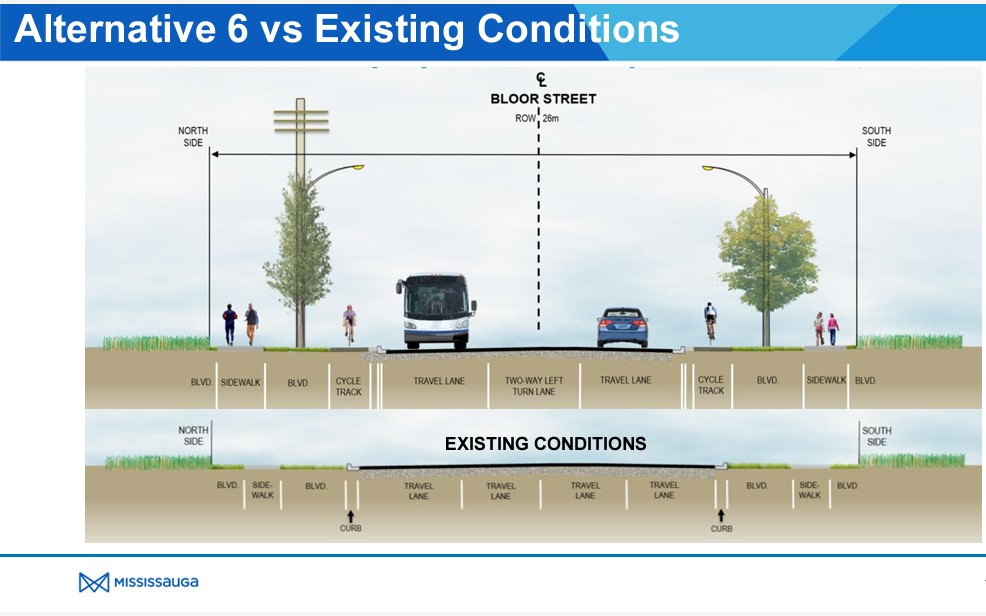
After extensive community consultation, Mississauga city staff recommended Alternative 6 for Bloor Street which widens the sidewalks, adds new separated cycle tracks, and a boulevard for trees and street lighting between the roadway and cycle tracks and the sidewalks and property lines. A continuous two-way left turn lane would allow motor vehicles to turn in and out of side streets and private driveways without conflicting with through traffic. This was approved by City Council in June 2023. Construction is scheduled to begin in October 2024.
This plan balances the needs of all road users, particularly students and seniors. It is great to see suburbs like Mississauga and Brampton rethink their streets to better serve all of their residents.
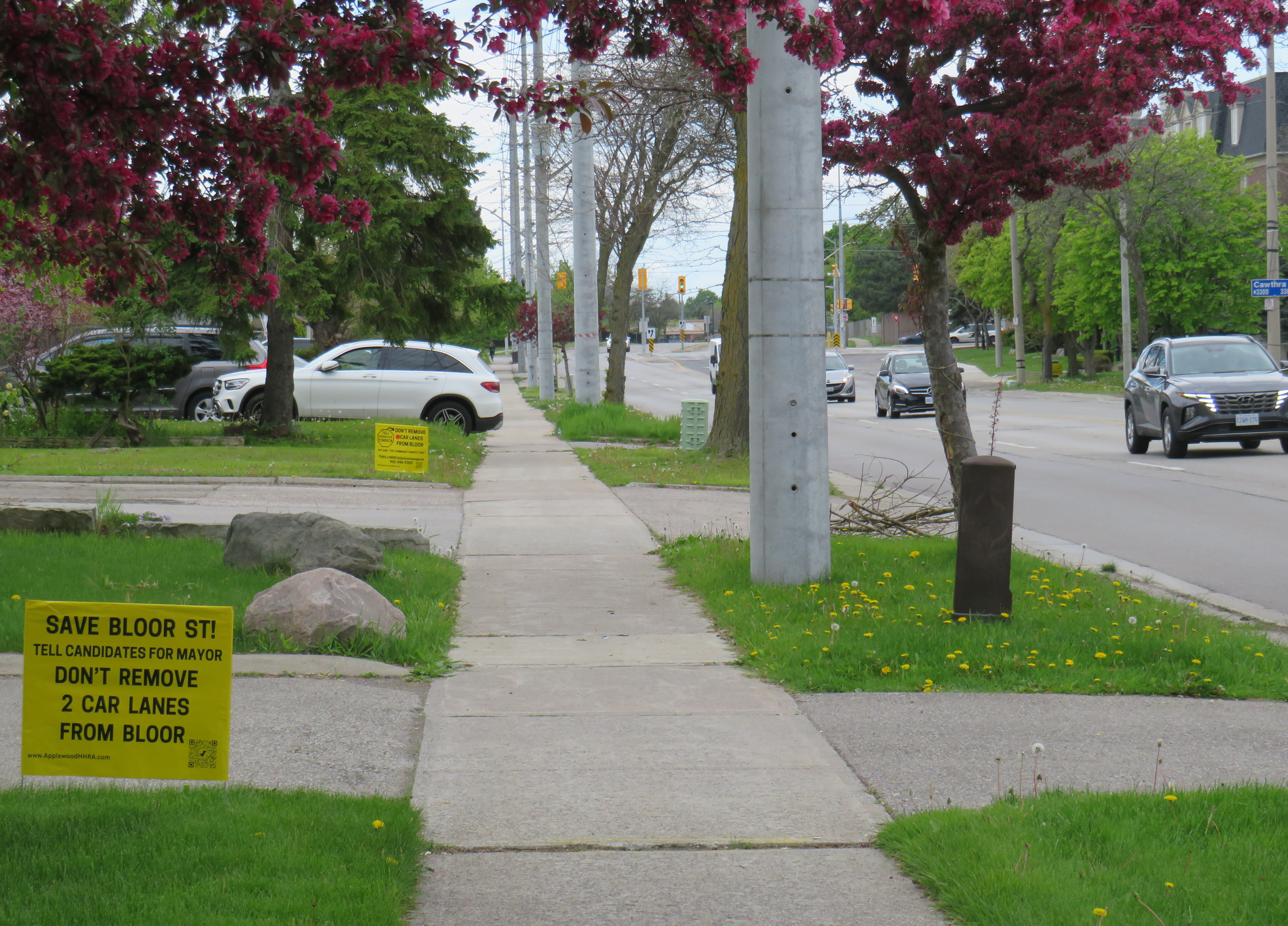
Bloor Street, looking east from Havenwood Drive. Note the “school route” sign and the cyclist using the sidewalk in the distance.Yellow lawn signs with the slogan “Save Bloor Street.” Note the SUV parked in a way that partially blocks the narrow sidewalk.
Bloor Street, whether it be a residential roadway in Mississauga, or a commercial street in Downtown Toronto, is not a place where drivers should expect nor be given ultimate priority over pedestrians, cyclists, or public transit riders.
Luckily, many Mississauga politicians already get it. Reporting for the Mississauga News, Steve Cornwell noted that fellow councillor and mayoral candidate Alvin Tedjo “stands by the approved Bloor project”, while Carolyn Parrish, another city councillor running for mayor declared that a reversal of last year’s council vote would not pass, saying that the “issue’s dead” at one mayoral debate. Ward 3 Councillor Chris Fonseca — whose ward covers most of Bloor Street — championed the changes.
Though Parrish has led several polls (with Damerla and Tedjo in second and third place), it is unfortunate to see a top-three candidate and sitting councillor using the Bloor Street redesign as a wedge issue. Mississauga is growing up. Some of its politicians should too.
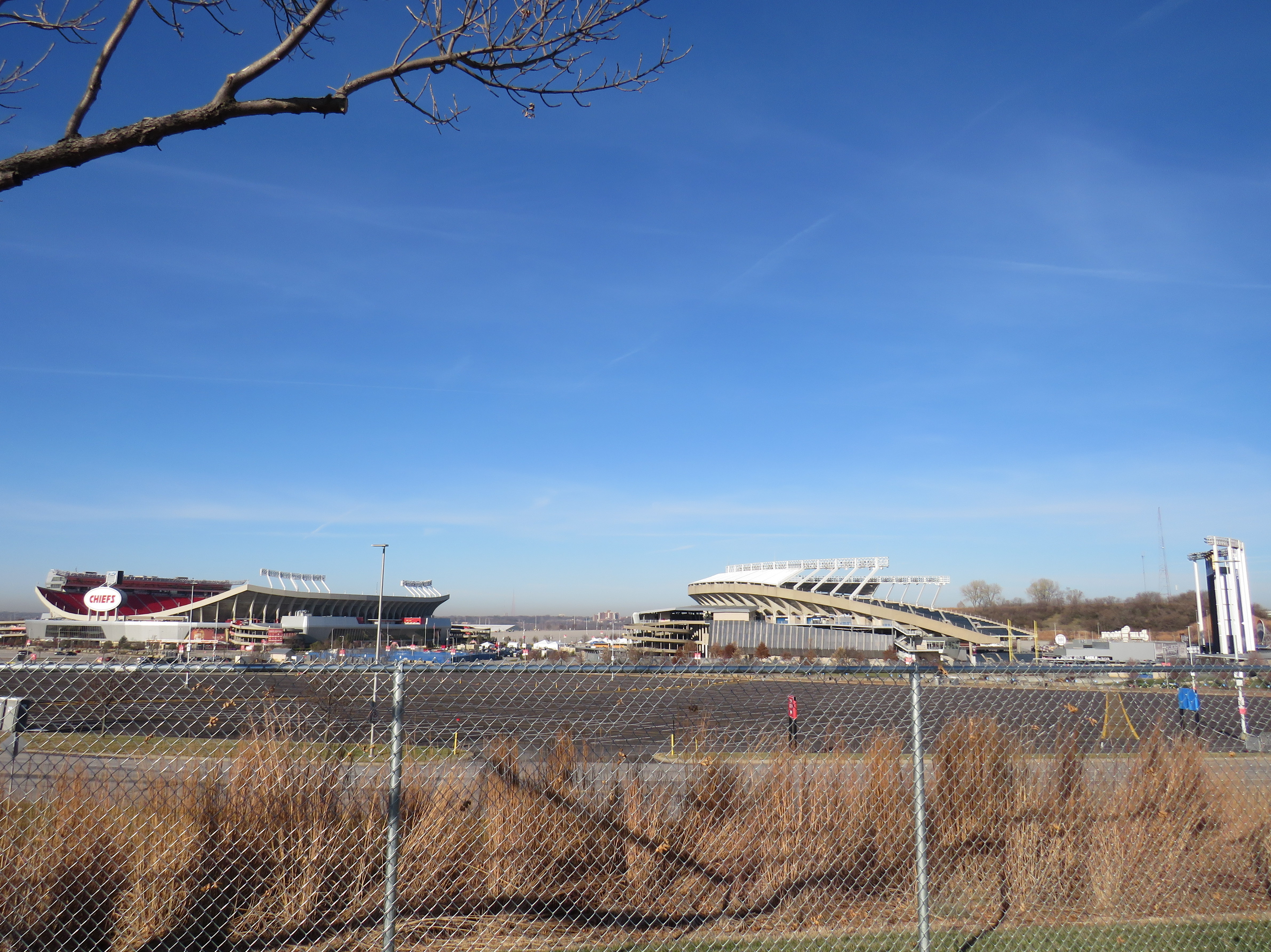
Truman Sports Complex, Kansas City, Missouri. Kauffman Stadium (MLB Royals) on right, Arrowhead Stadium (NFL) on left. Kauffman Stadium has the lowest Walk Score in the league. Both sports venues have especially poor transit access, even for Kansas City.
One of the best — or worst — experiences in North America can be going to see a ball or hockey game, concert, or other special event at a sports arena or stadium. Perhaps you want to make a day of it, taking in the city, going for a meal or drinks first and meeting up with friends or family. Or maybe you want just to park in a lot hours before game time and have a cookout.
But the trip to and from that venue can make or break the experience. Does it involve hours in gridlock? Does it mean a long line in the outdoors for a shuttle bus? Or can it mean a short walk to a transit stop and quickly getting on your way?
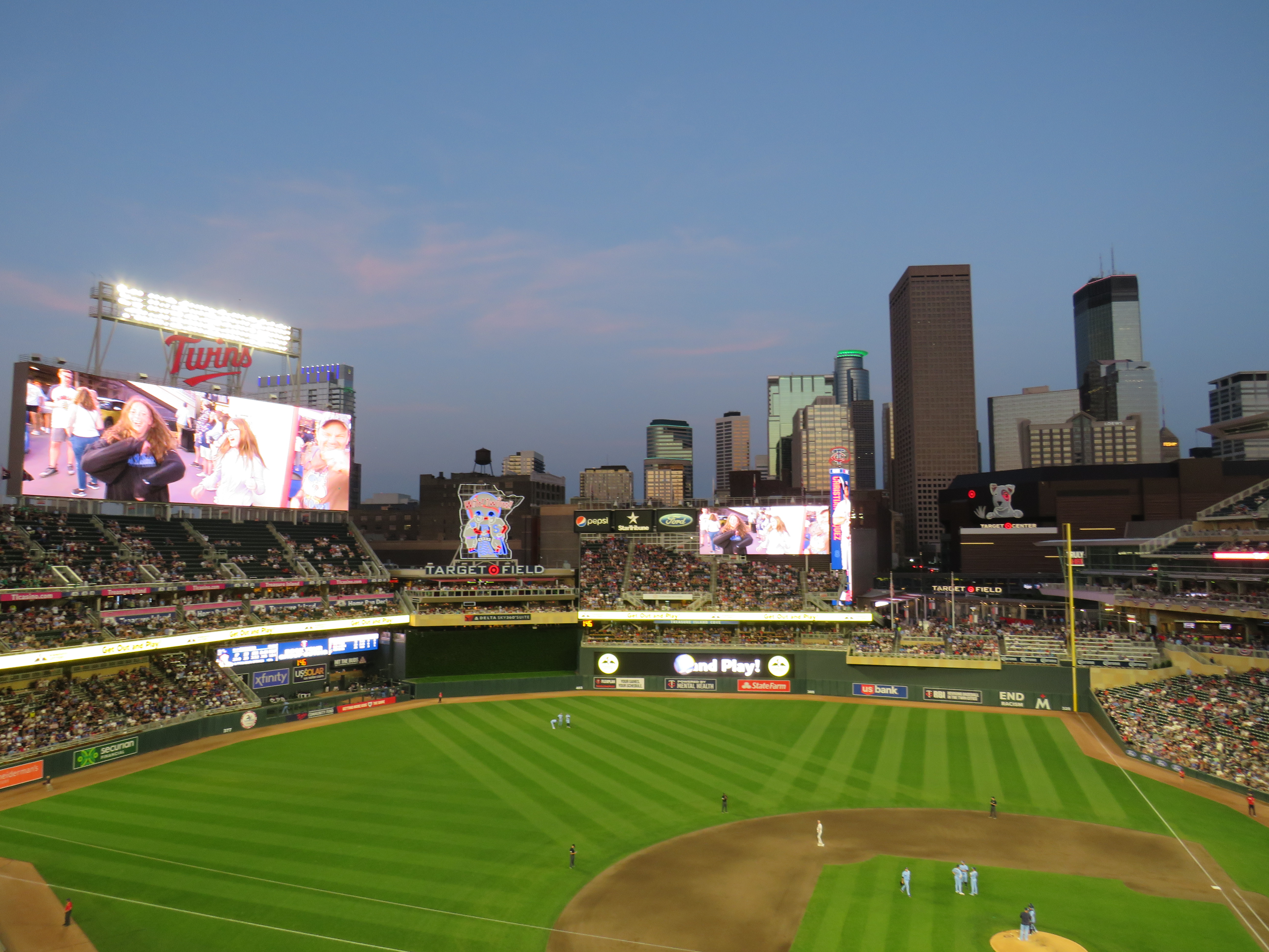
Target Field, in Downtown Minneapolis. Both light rail lines stop right next door.
Last summer, I got to see the Toronto Blue Jays play at Target Field in Downtown Minneapolis. The Jays have a Canada-wide fan base, and the Twin Cities have the closest baseball venue to places like Thunder Bay, Winnipeg, and even Regina and Saskatoon. It felt like a home game with a very pro-Toronto crowd.
Earlier that day, I noticed plenty of people wearing Jays hats and jerseys that were making the most of their road trip. They flooded local restaurants and bars. They checked out museums and the city’s signature parks. The Mall of America, at the other end of the Metro Blue Line LRT, was also full of Canadians. Minneapolis has a lively downtown, with very good bus and rail connections to the airport, the malls, St. Paul, and elsewhere.
Walkability and transit access are the key fostering a great fan experience, for promoting safe, accessible, and sustainable travel to and from the venue, and for supporting local businesses. Though economists and urban experts will — rightly — dispute the economic benefits of subsidizing new sports stadiums, if they must be built, they should allow spectators to get around without a car as much as possible to reduce congestion, curtail impaired driving, and create a vibrant urban environment that everyone can enjoy.
I used Redfin’s Walk Score tool to rank the venues of six major leagues in Canada and the United States: the CFL, MLB, MLS, NBA, NHL, and NFL; I also comment on their transit connections. Toronto’s three venues do very well, as do NBA/NHL venues in major cities like New York, Washington, and Los Angeles. Not surprisingly, football stadiums — especially NFL venues — do poorly.
Streetcars backed up eastbound at King and University, November 28, 2023
On Tuesday, November 28, the University of Toronto’s School of Cities released their report that looked at vehicle movement and traffic violations on the King Street Transit Priority Corridor. They found that there are, on average, 6,800 illegal turns and through movements at intersections on the corridor, and less than 0.3% of offenders are stopped by Toronto Police and ticketed. Traffic enforcement was heaviest between November 2017 (when the pilot began) and March 2020 (when the COVID-19 pandemic restrictions began). Enforcement has not caught up since then.
The U of T School of Cities has provided invaluable quantification of what many Torontonians have suspected for years: the King Street Transit Priority Corridor is broken, and that there is little being done to fix it.
The transit priority corridor, which runs between Bathurst Street in the west and Jarvis Street in the east, has restrictions on through vehicle movements, where motorists must turn right at most intersections. Until 10 PM daily, only TTC buses and streetcars, emergency vehicles, and bicyclists are exempt. After 10 PM, taxis may also continue through the corridor.
The pilot program launched on November 12, 2017. The initial pilot, in which signs were erected, Jersey barriers placed to restrict the curb lane, and TTC stops moved to the far side of most intersections, was intended to optimize permanent streetscaping improvements, streetcar stop placement and transit optimization, get motorists acquainted with the new rules (at first, only warnings were issued by police) and allow time for Toronto City Council to decide on whether the pilot should be made permanent. Council approved making the transit priority corridor permanent on April 16, 2019.
Though Toronto City Council voted to transform King Street permanently, no work has started on the streetscape or public realm to do so. Just like Union Station, temporary Jersey barriers remain in place. The relocated TTC streetcar stops are left at road level, without transit shelters or accessible curbs. Drivers routinely ignore restrictions, with only a 0.3% chance of getting a $85 or $110 ticket. Meanwhile streetcars get stuck and transit riders get nowhere. On Wednesday, November 8, a Toronto police officer decided to enforce congestion on King Street… by ticketing a streetcar operator stuck in the intersection at University Avenue.
A motorist, ignoring several signs, proceeds straight through on King Street eastbound at Spadina Avenue
The problem is not just limited to through movements on King Street, though. On Tuesday, November 28, I stood at the corner of King and Spadina between 4:00 PM and 4:20 PM. The backup of cars and trucks headed southbound towards the Gardiner Expressway extended into the south side crosswalk and into the eastbound lanes at times. Motorists are not permitted to enter an intersection on a green light if they cannot clear it before the light turns red; this causes gridlock. But on more than one occasion, streetcars and pedestrians were impeded by illegal intersection blocks.
At Spadina and King, a truck and three passenger vehicles block the south side crosswalk and prevent a streetcar from proceeding straight on a green light
After standing at King and Spadina, I walked over to King and University, where the Toronto Police charged a streetcar operator earlier this month. At 5 PM, eastbound streetcars were lining up between University and John Street, unable to proceed.
Traffic jammed at King Street eastbound at University Avenue
However, motorists were able to turn right and left from University Avenue to eastbound King, blocking the east side crosswalk to pedestrians and ensuring that no streetcar could continue across. I spoke to one operator, who told me that the day before, he was stuck there for a half hour before he could move across.
The University and King intersection, at 5:00 PM on Tuesday, November 28. Note the blocked crosswalk and the line of streetcars, all with their hazard lights blinking. Eventually, one streetcar operator decides they had enough, and occupies the intersection.
While there, I counted several motorists who passed to the right of the stopped streetcar, and instead of turning right as permitted, they went straight, only contributing to the blockage ahead.
Two eastbound cars pass a stopped streetcar on the right to join the congestion ahead
The problem downtown is exasperated by several road closures. Queen Street is closed between Bay and Victoria Streets for Ontario Line construction; this will last for at least five years. Adelaide Street, which is one-way eastbound is closed at York Street due to the delayed Adelaide Street diversion track installation that is supposed to allow Queen Streetcars to divert around the Ontario Line closure. York Street is also closed at Adelaide. There are several other lane closures on Bay, Yonge, and Richmond Streets and University Avenue for utility work.
Adelaide Street is likely to remain closed at York until early 2024
Yet, one would hope that something was done to allow transit riders to get through the downtown core, especially as the city has been aware of the severe congestion for weeks at this point. The city needs to move ahead on permanent streetscape changes to further discourage through traffic on King Street by closing the curb lanes at the far side of each intersection.
It is also clear that the Toronto Police are not too interested in ticketing motorists on King Street. Even if they were, it wouldn’t be enough, as it takes 10-15 minutes to stop and ticket a driver; automatic ticketing, similar to red light cameras, would be more effective, though traffic officers can still be strategically deployed at congestion hotspots.
It’s beyond time for this city to take transit seriously again. King Street would be a great place to start.