Tag: Baseball

  • A walk to the ballpark

    Returning to Downtown Pittsburgh across the Roberto Clemente Bridge after the game and a fireworks display

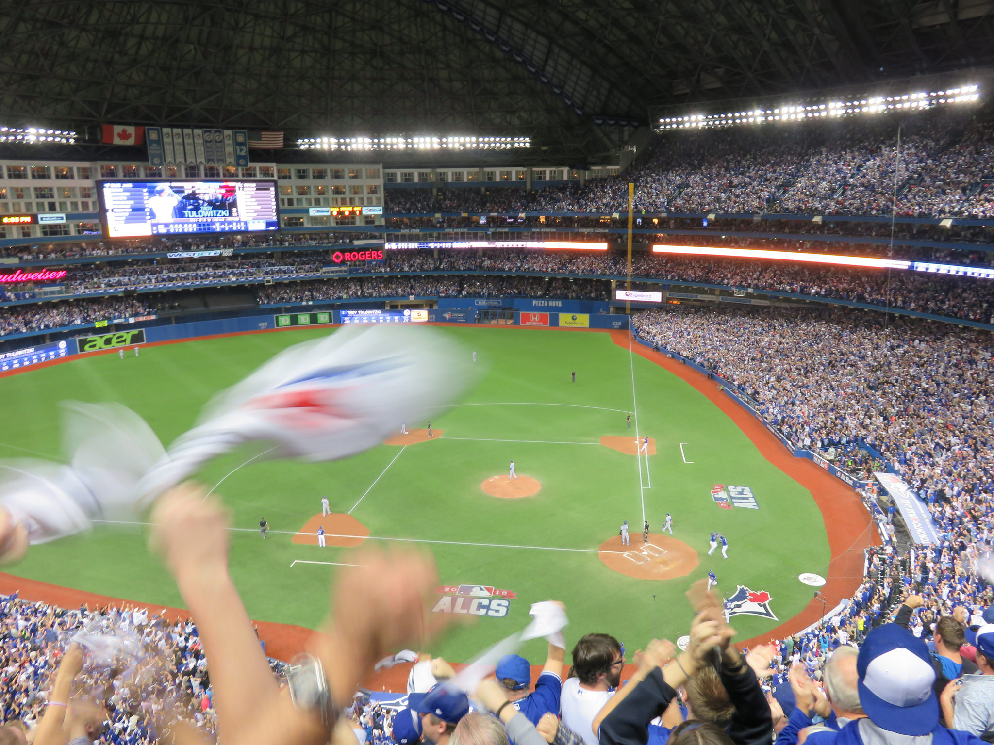
    Earlier in June, a friend and I took a weekend road trip to Pittsburgh, a five-hour drive southwest of Toronto. On our first night there, we took in a ballgame at PNC Park, where the hometown Pirates hosted the Minnesota Twins.

    Though I do not follow the Pirates (who are in the National League) nor the Twins (who are in the AL Central), I was excited to take in a ballgame in Pittsburgh because I have heard about the park’s intimate confines, the great view of the Pittsburgh skyline, and the fireworks that follow certain Friday and Saturday night games. PNC Park lived up to the hype.

    Among the major North American sports leagues, Major League Baseball has the most significant differences between venues. Unlike hockey, basketball, soccer, and football fields, the dimensions of each playing surface vary considerably, as does the architecture. PNC Park was built in the retro-classic style similar to Baltimore’s Camden Yards; it opened in 2001. When the naming rights for the new publicly-financed stadium was purchased by local bank PNC, the city renamed the adjacent 6th Avenue Bridge for beloved Pirates player Roberto Clemente, a Hall of Famer and a humanitarian. That bridge is closed before and after each game to motor vehicles so that fans can walk and bike across the Allegheny River to and from downtown.

    Statue of Roberto Clemente located between the stadium and the bridge renamed in his honour. No statues of cable tycoons can be found here.

    The skyline view from behind home plate is spectacular, showcasing the most iconic buildings and some of the many bridges crossing the three rivers in the downtown area. With lots of washrooms, a wide concourse, and plenty of food and drink concessions, the stadium felt intimate, yet uncrowded. Lineups were always short, and where play wasn’t visible (such as in the washrooms), speakers played the radio broadcast. Ushers were very friendly and helpful as well.

    View from up behind home plate

    The game was followed by a 10-minute fireworks display, with the rockets launched off a barge in the Allegheny River.

    Finale of fireworks show

    Though transit access is quite good — there is a station one block away on Pittsburgh LRT’s North Shore extension — many fans walked part of the way home. Downtown parking garages — built for office commuters — provide much of the parking demand, so there are few surface parking spaces surrounding the stadium. Even the football stadium, a few blocks to the west, is mostly served by parking garages and another LRT station. Hotels, restaurants, museums, and apartments neighbour the two North Shore stadiums.

    Walkability and transit access are the key to fostering a great fan experience. Walkable stadiums promote safe, accessible, and sustainable travel to and from sports venues, and help support local businesses. Downtown locations have the advantage of having better transit access, existing parking facilities, and in the case of Pittsburgh (or Detroit, or Minneapolis), a downtown ballpark can be a point of civic pride, showing off the city to its inhabitants, and to a much larger audience.

    To see how your local sports venue ranks, visit my Story Map here.

  • The streetcars of Hiroshima: a symbol of resilience

    The Hiroshima Peace Memorial (A-Bomb Dome), with modern Hiroshima rising beyond. Despite its fame, there’s so much more to the city than the memorials.

    My wife and I recently came back from an 18-day trip to Japan. It was my first time visiting the country. We stayed in three cities: Tokyo, Kyoto, and Hiroshima, though we made good use of our Japan Rail Passes and made several day trips as well.

    Despite hundreds of years of history, Hiroshima is best known as the city upon which the United States dropped the first atomic bomb on August 6, 1945, in the final weeks of the Second World War. The memorial (originally the Hiroshima Prefectural Industrial Promotion Hall, but widely known as the A-Bomb Dome) is a UNESCO World Heritage Site, and stands as a reminder of the destructive force and tragedy of modern warfare.

    Most tourists to Hiroshima may only visit the Peace Memorial Park and associated memorials, or take a ferry to Miyajima to visit Itsukushima Shrine and its famous floating gate. But what’s remarkable about Hiroshima is the city’s resilience and pride, and there is much more to see, do, and taste. For me, one of those things is the city’s streetcars.

    The Hiroshima Electric Railway, known as Hiroden for short, operates Japan’s largest street railway network, as well as many local buses and ferries. While most Japanese cities abandoned their streetcars after the Second World War, Hiroshima made a conscious decision to retain its streetcars; they are a symbol of Hiroshima’s resilience. Though 108 out of Hiroden’s 123 streetcars were damaged or destroyed, seven days after the blast, service resumed on the suburban Miyajima line.

    IMG_0264-001Map of the Hiroden streetcar network, with information in Japanese, English, Korean and simplified Chinese

    Today, Hiroden operates 271 streetcars, and it has an eclectic fleet. All streetcars are double-ended, and articulated cars operate with both an operator and a conductor. Passengers pay on exit, though customers using a farecard must tap on and off. (The city fare is a flat 180 yen, though an additional fare is charged on the Miyajima Line.)

    IMG_0279-001Two newer Hiroden low-floor streetcars pass each other on Aioi-dori. 

    Among Hiroden’s assets are two vehicles (#651 and #652) that survived the atomic blast. In the 1960s and 1970s, Hiroshima purchased used streetcars from other cities that were abandoning their systems, including Kyoto, Osaka, and Kobe, some of which still operate today. New articulated low-floor streetcars augment the streetcar fleet, providing barrier-free transit. A complete description of the Hiroden fleet is available on the local transportation museum’s website.

    IMG_0794-001Streetcar #1912 was built in 1957 for Kyoto’s municipal railway. It was acquired by Hiroden when Kyoto abandoned its streetcar system in 1978.

    (more…)

  • Mapping Major League Baseball’s stadiums by walkablity, transit access

    22078160783_012aad4fb6_k

    What major league ballpark is the easiest to get to by public transit? Which stadium has the highest walk score? And where does the phrase “take me out to the ball game” absolutely require getting in a car and fighting traffic to do so?

    Over at Torontoist, I explore these questions in more detail. I created a map of all thirty major league stadiums (and the 2017 home of the Atlanta Braves). About half the stadiums are located in downtown areas or urban neighbourhoods, close to transit stations, bars, restaurants, and shopping; the other half are generally surrounded by parking lots.

    SkyDome isn’t a great ballpark, especially when the dome is closed, but in these rankings, it does really well.