In late 2024, I phased out my use of the social media website previously known as Twitter; by November of last year, I completely deactivated my account. Though I spent a lot of time on Twitter since 2012, when I first joined to follow City Hall news, I found it to be less and less enjoyable, even as my follower count grew. The lack of moderation, along with the rise of trolls and bots, made it less useful; the purchase of the platform by Elon Musk, who changed the verification scheme to promote paid users over official agencies and quality posters made it even worse. Despite so many professional and social connections made through that social media platform, it was time to leave.
The time to leave Meta’s platforms (Facebook, Instagram, and WhatsApp) has also come. Meta just changed its content moderation policies, including the “Hateful Content” policy, which according to Wired, “will permit users to accuse transgender or gay people of being mentally ill because of their gender expression and sexual orientation.” Its policies on disinformation have also changed for the worse. Mark Zuckerberg has joined Elon Musk in supporting President Re-Elect Donald Trump, whose own politics benefit from disinformation and hate.
Facebook was already becoming unusable. The ban on sharing actual news content in Canada (rather than supporting actual journalism) stopped me from sharing some of my own content on the platform, as well as expressing interest or thoughts on local news items. My feed was increasingly full of unwanted content such as “suggested for you” posts and an increasing number of ads.
But the latest decisions have made my decision to leave easier. I will be winding down my presence on Facebook, while deactivating my (rarely used) Instagram account completely.
You can find me here on this website, where I will continue to post my thoughts. I can also be found on BlueSky and LinkedIn, at least for now.
Previously on this website, I discussed the problems with the unsightly, intrusive, and poorly thought-out mess of Jersey barriers plopped in front of Union Station along Front Street. They have not only been an eyesore unbefitting a signature heritage structure, but they have also been difficult for pedestrians to navigate around, especially at the corners of Front and Bay and Front and York.
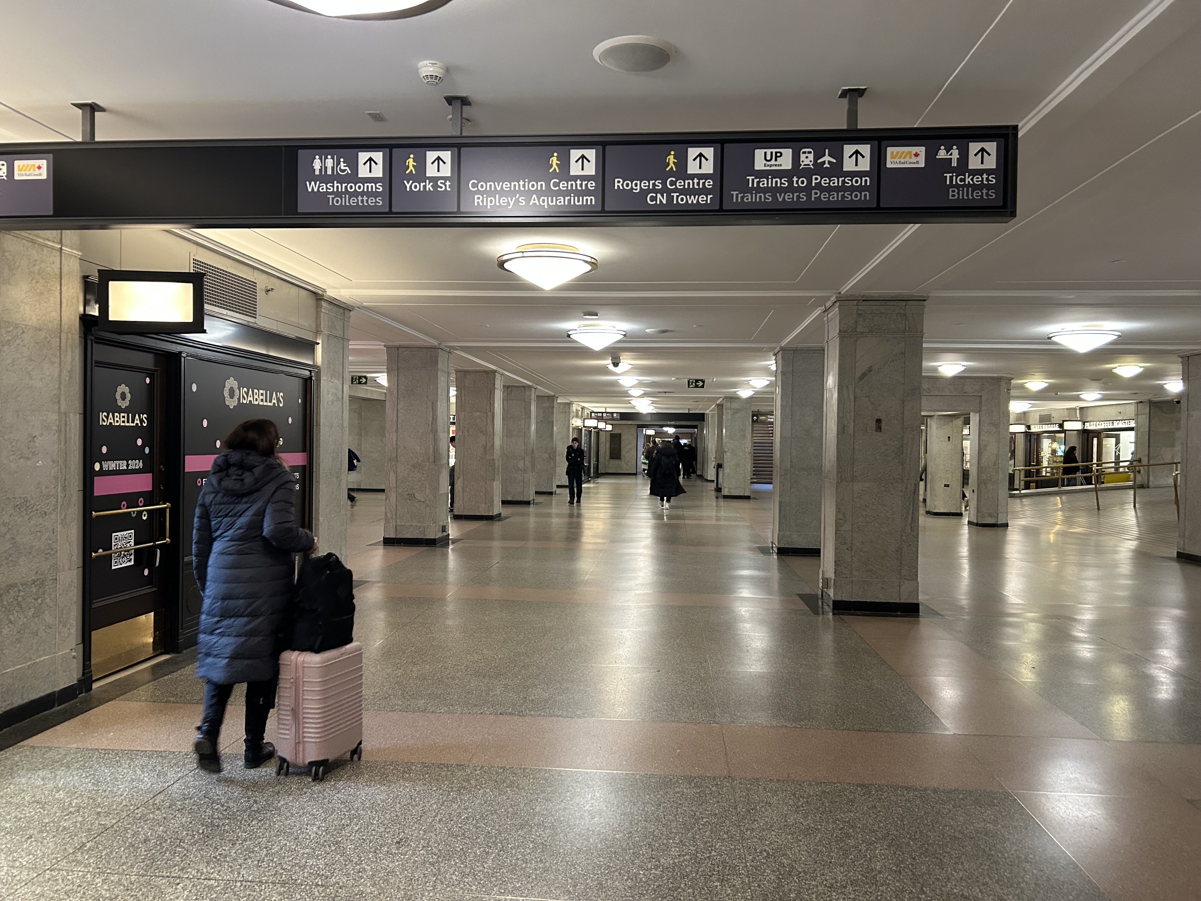
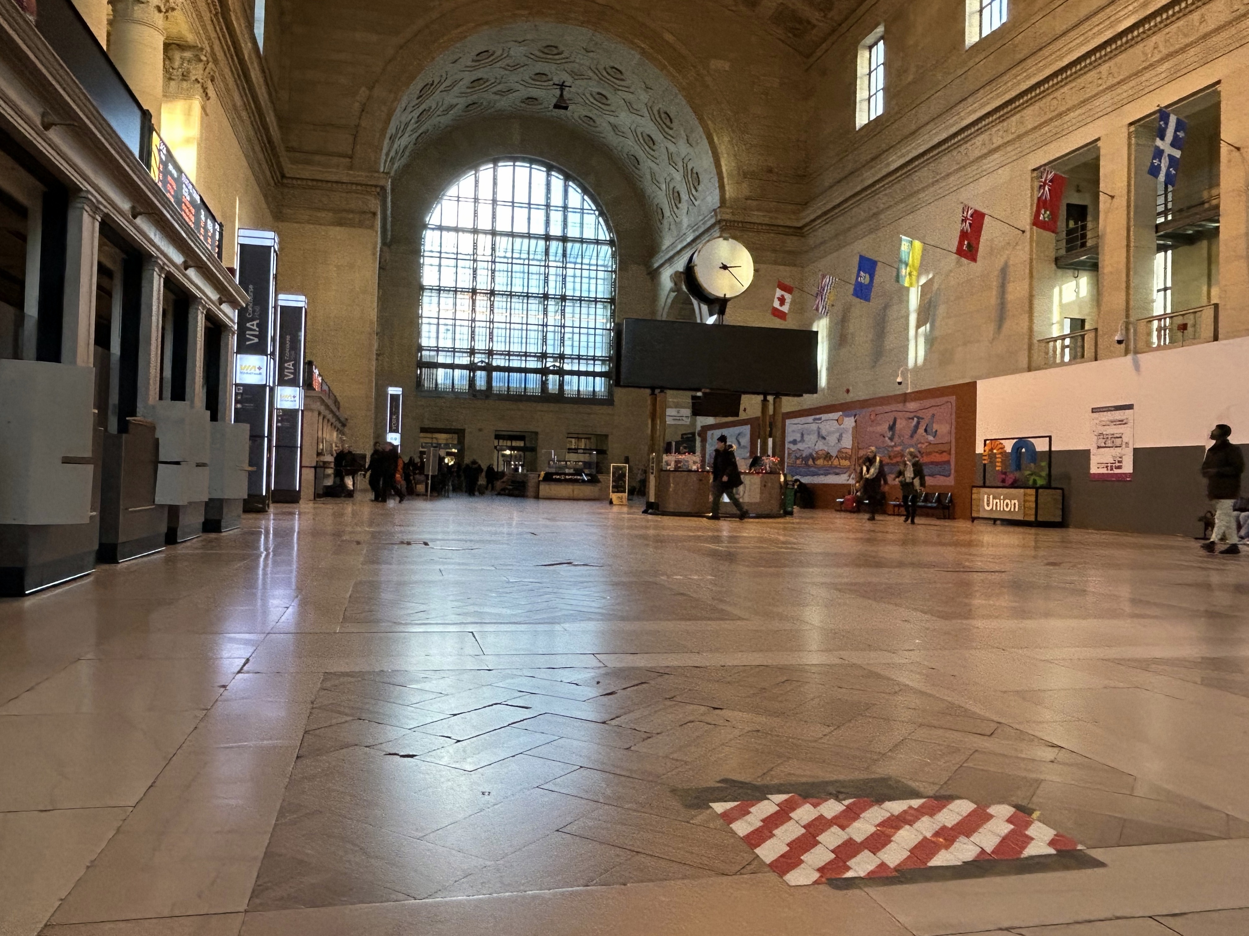
Inside Union Station, however, a lot has changed in the last few years. In general, pedestrian flow within the station building has improved, especially with the opening of the GO Transit York Concourse, which provides a second access point for regional trains. Flow between subway, train, and shops is considerably improved; there are also a lot more food and retail options befitting a central transport hub.
Despite new escalators and elevators, accessibility in Union Station remains poor. Though technically, the station is fully accessible to anyone using a wheelchair or other mobility device, the wayfinding is absent in key areas. There is only one small elevator that directly connects the subway level with the Great Hall, UP Express trains, and Front Street. An accessible route is also difficult to find.
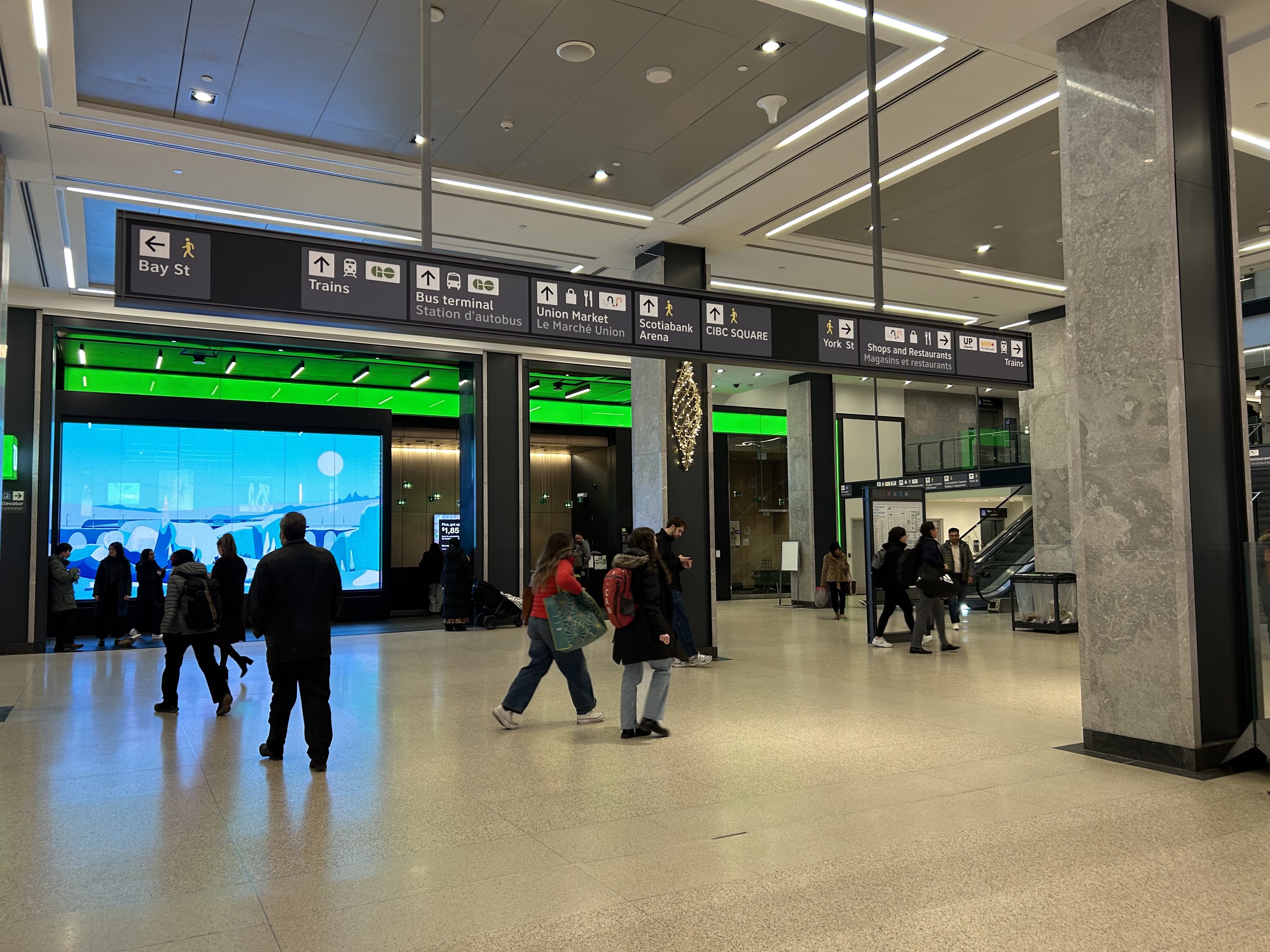
The view after entering the Union Station complex from the TTC subway. The overhead sign shows the way to GO trains, the bus terminal, the Union Market shopping area, Scotiabank Arena, CIBC Square (an office building), York Street, more shops and restaurants, and VIA and UP Express trains.
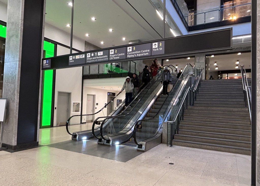
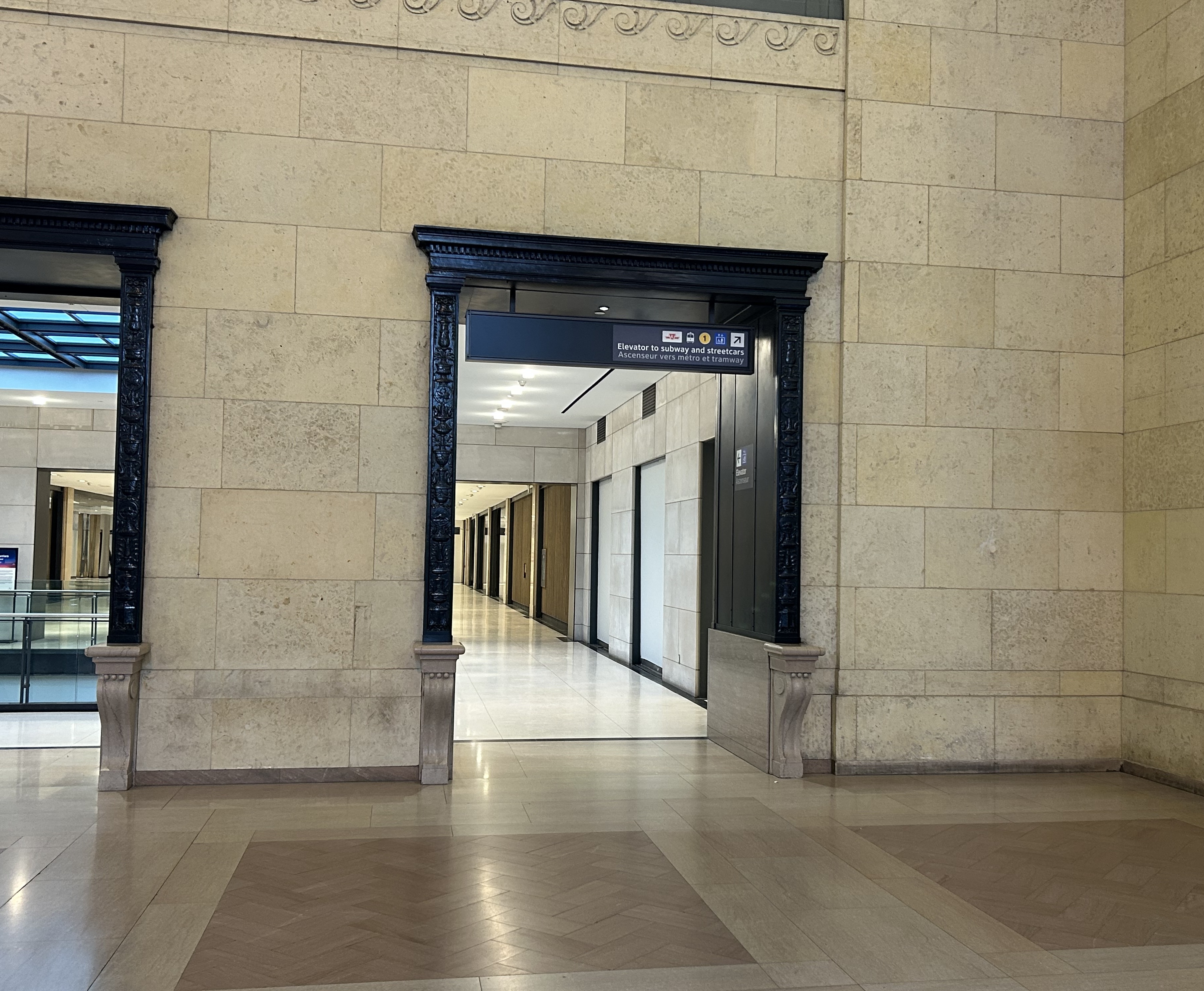
Imagine entering Union Station from the adjacent TTC subway station with a wheeled device or a mobility aid. There is a large concourse with signs leading forward towards the GO Transit York Concourse along with Scotiabank Arena, the bus terminal, and Union Station shops and food kiosks. To the left is Bay Street, and to the right are a set of escalators and stairs leading up towards VIA Rail and UP Express trains. Behind the stairs and escalators is a single elevator, hidden away.
To the right is a set of escalators, stairs, and hidden behind, a poorly marked single elevator.These lead towards UP Express and VIA trains, York Street, and attractions such as the CN Tower, the Convention Centre, and Rogers Centre.
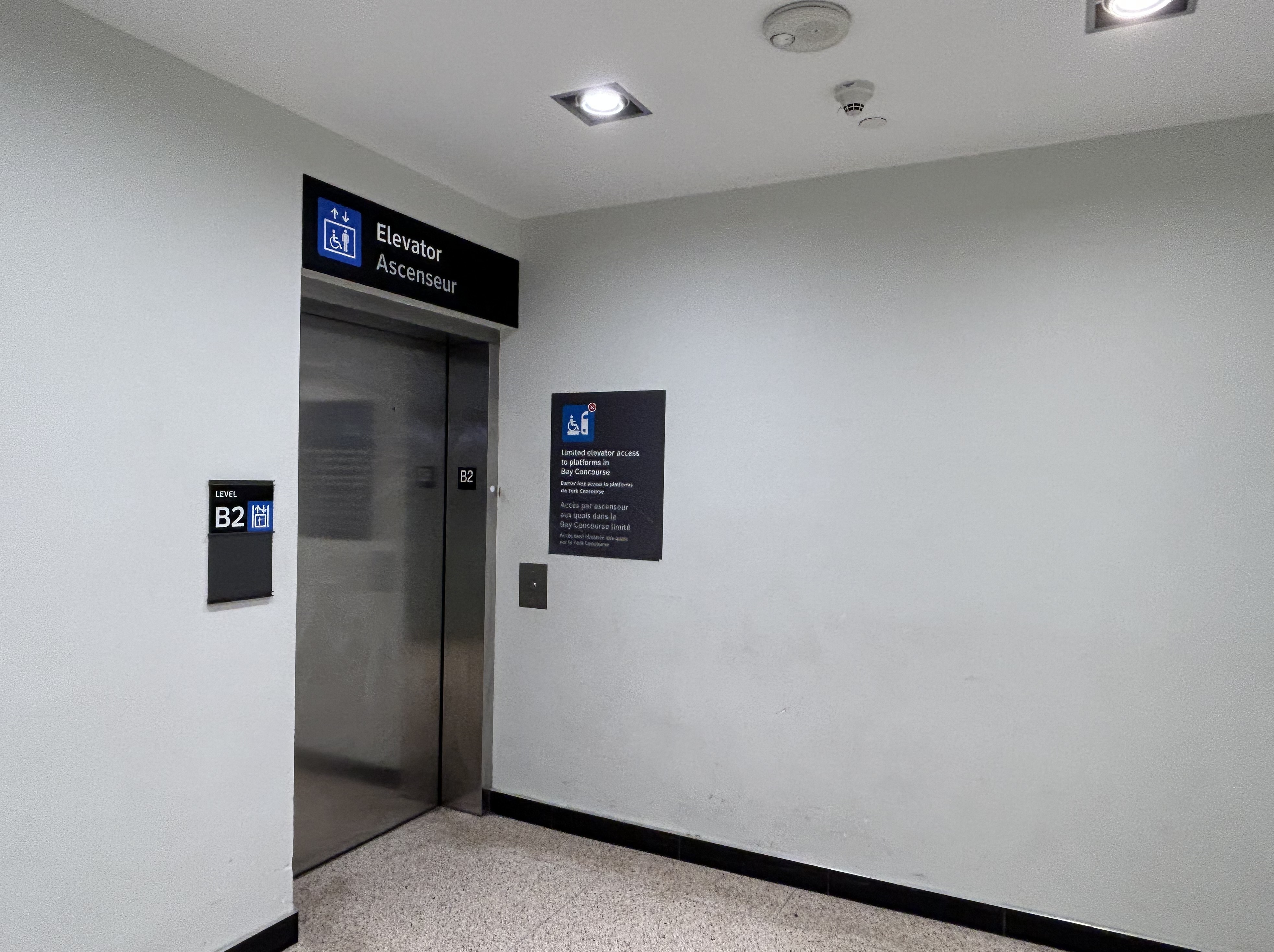
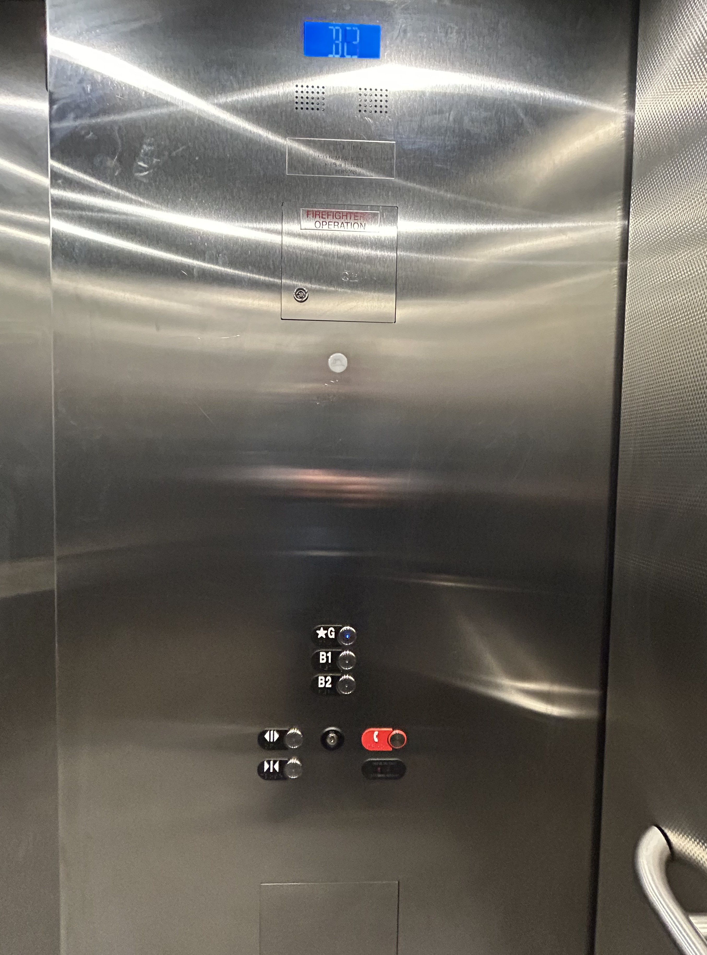
The elevator provides no information other than a sign that indicates that this is, in fact, an elevator, and this is the B2 level. This is a single, small elevator, which operates slowly.
The elevator at the B2 (subway) level
Once inside the elevator, there is no information other than buttons marked “G”, “B1”, and “B2”. There is nothing to tell the elevator user what is accessible from each floor.
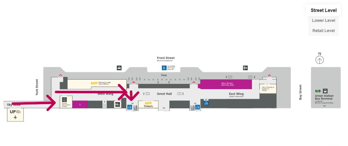
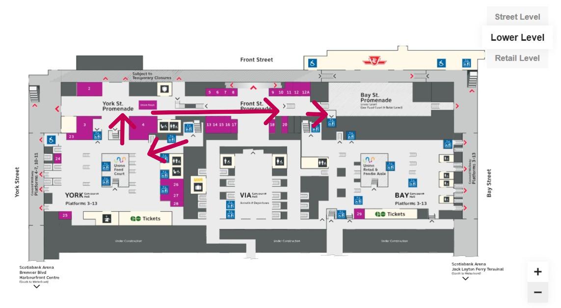
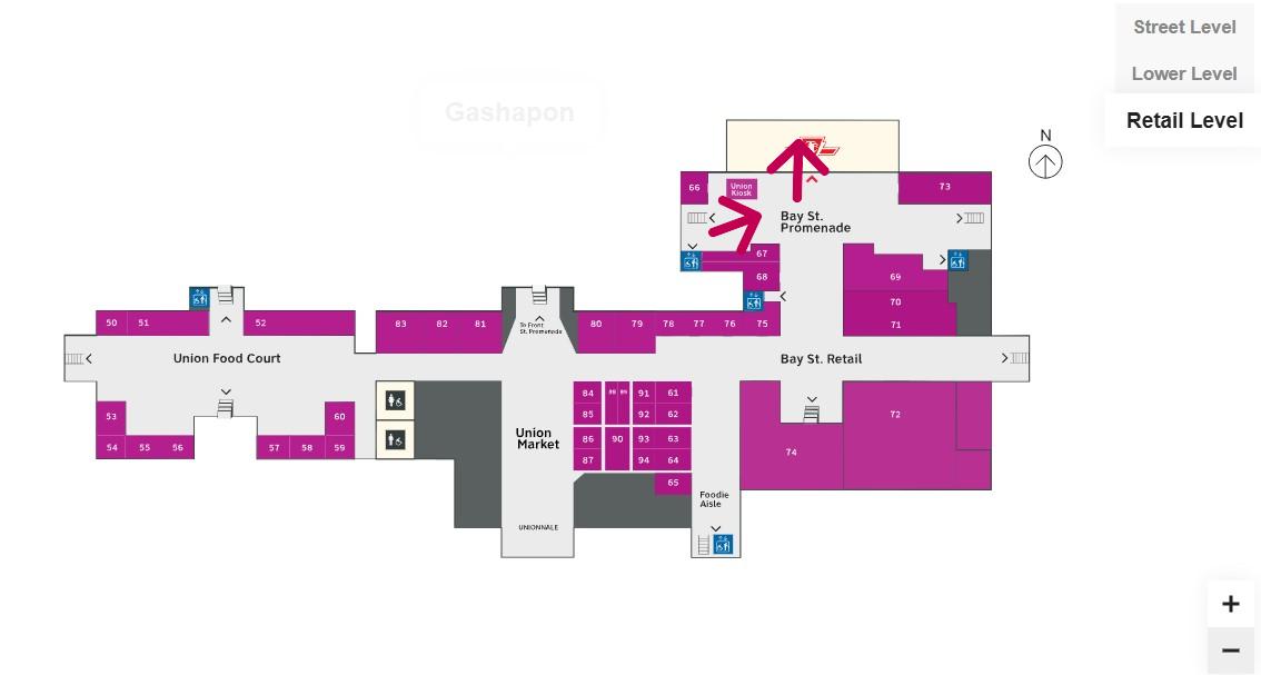
Confusingly, the official Union Station map directory calls the three levels “Street Level” (G, the Heritage structure including the Great Hall, West and East Wings, along with the path towards UP Express and the Skywalk), “Lower Level” (B1, the GO York and Bay Concourses, the concourse beneath the Great Hall, and the VIA departure area) and “Retail Level” (B2, including the food court, food hall, and connections to the subway). In the elevators, the audio prompts only mention the three level names.
Inside the elevators, there is no indication what each level is, or where they lead to — the buttons and empty spaces beside them just show G, B1, and B2 levels
At G level, which includes the Great Hall, VIA Rail departures and business class lounge, and the passage west towards UP Express trains and the Skywalk to the CN Tower and Rogers Centre, the elevator is also hidden behind a wall.
The only elevator connecting the Great Hall, the lower concourse, and the subway level is hidden, with tiny signage directing travelers to it
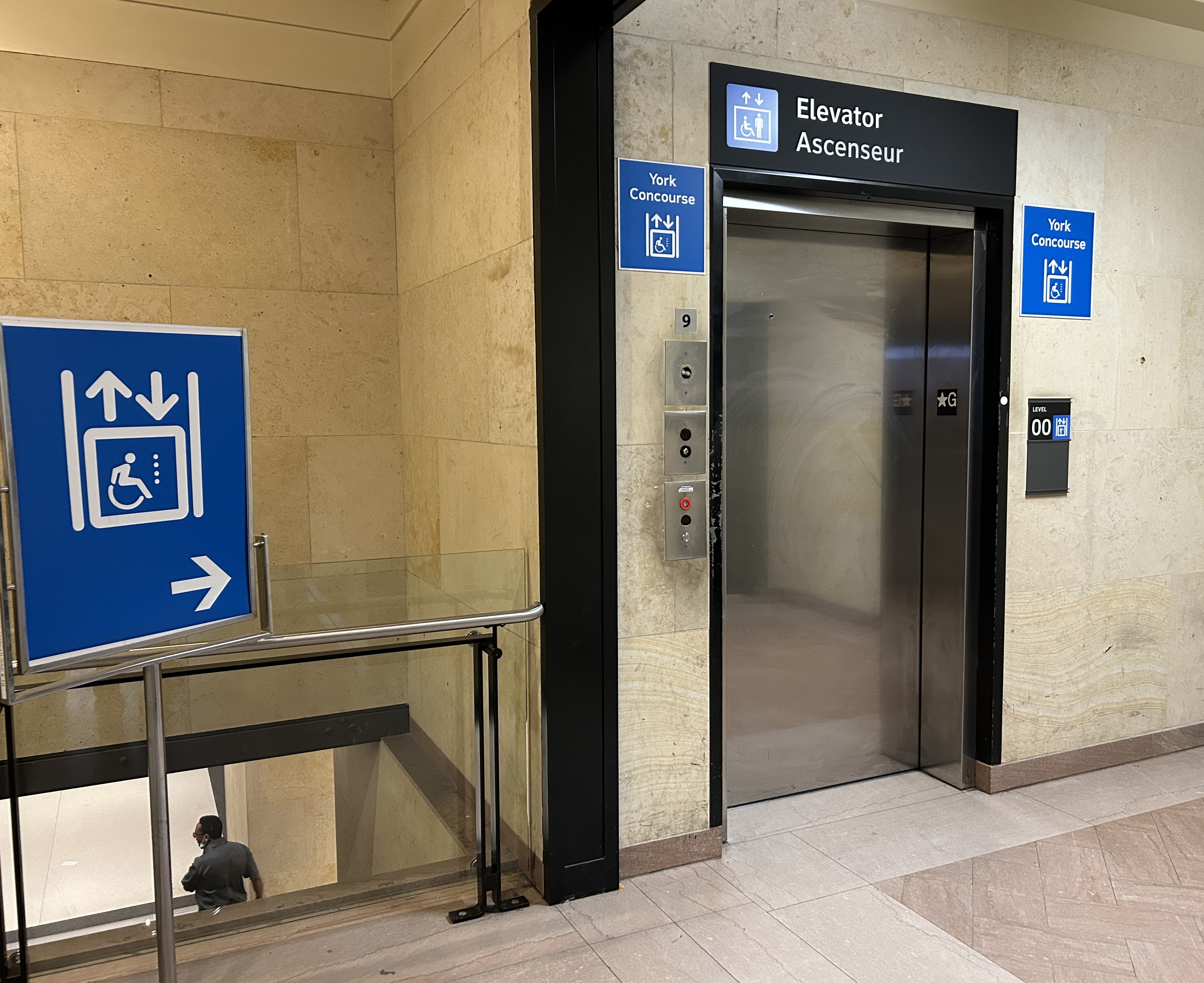
On the west side of The Great Hall, there is also an elevator, beside the stairway down to the GO Transit York Concourse. This elevator does not serve level B2.
York Concourse elevator, on the west side of Union Station’s Great Hall
If the traveler was only connecting from subway to UP Express with a heavy bag, and not using a mobility device, they might decide to take an escalator from the subway B2 level to the B1 level, the lower Union Station concourse originally intended as an arrivals area for intercity trains. However, there is no elevator or upwards escalator to be seen.
Looking west in the lower concourse, towards York Street and UP Express trains
If one knew Union Station well, they could make a lengthy detour through the ramps in the VIA Rail area to get to the Great Hall or go around through the GO York Concourse to reach the elevator or up escalator to the Great Hall. But these routes are not marked from the lower concourse area.
To show how difficult it can be to navigate the station while using a wheeled device (be it a wheelchair, stroller, or wheeled luggage), I shot this video showing how a first-time visitor getting off an UP Express train from Union Station would try to find the TTC subway entrance.
Video depicting 9-minute trip at a normal walking speed between the UP Express area and TTC subway station entrance, using first available elevators each time.
At no point was there any visible signage showing the most direct route for someone requiring a barrier-free path from UP Express to the subway. The maps below show the route I took:
Route from UP Express to the Great Hall and York Concourse Elevator (Street Level, or G). Arrows are added to mark the route I took in the video.Path through York Concourse, lower Union Station concourse (Front St. Promenade) – the B1 Level, and to the second elevator to the Bay St. Promenade (subway level). Arrows are added to mark the route I took in the video.Last part of the trip on the Retail Level (B2) to the subway station entrance. Arrows are added to mark the route I took in the video.
Whenever I travel through an international airport — Toronto Pearson is a good example — I never have to think too hard about where the accessible routes are. Escalators are easy to find. There are banks of two or three large elevators in strategic locations on the ground side of airports, connecting departure and arrival areas, as well as ground transportation facilities. As Canada’s busiest transport hub — busier than Toronto Pearson Airport even — Union Station’s elevators and escalators should be plentiful and easy to find.
I am aware that there are particular challenges at Toronto Union Station — the City of Toronto controls only the common areas, such as the Great Hall, the retail areas, and the main entrances. Metrolinx, the agency responsible for GO Transit and UP Express, controls the York and Bay Concourses, as well as the UP Express station area. VIA Rail maintains its departures area. There are also heritage elements that need to remain intact, such as the Great Hall. But these issues of ownership and heritage preservation do not excuse the difficulty of getting around with a mobility device or even a wheeled bag.
Why weren’t multiple elevators installed connecting all three levels, to improve capacity, speed, and provide redundancy in the case of an elevator outage? Why are there not easy-to-find elevators in the West Wing near the UP Express area?
Judging by the condition of the signature Great Hall itself, there is work yet to be done before Union Station is fully restored to its 1920s grandeur. It should not be too hard to improve accessibility and wayfinding as well. Not just for Torontonians, but for international travelers too.
The Great Hall floor is still cracked and patched, with electrical tape covering some of the damaged sections
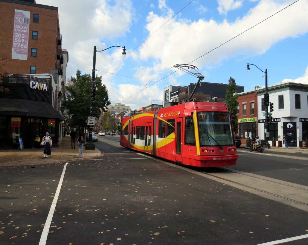
In mid-November, I found myself in Washington DC, accompanying my spouse as she had multiple days of work-related meetings. While I spent part of my time visiting cities in Delaware, Maryland, and Virginia, I also visited several neighbourhoods in Washington itself. Among the things I wanted to see for the first time was the D.C. Streetcar, one of nearly a dozen systems built across the United States in the last two decades. I had already taken rides on modern streetcars in Atlanta, Detroit, Kansas City, Cincinnati, as well as Portland and Seattle, coming away mostly unimpressed — though Portland, Detroit, and Kansas City show some promise. Washington’s small implementation didn’t win me over either.
I grew up in Brampton, a suburb of a city that maintained a large legacy streetcar fleet. Growing up, I thought streetcars were the greatest thing: big, smooth, quiet, gliding through some of Toronto’s most interesting neighbourhoods. I watched as the city expanded its street railway network along the waterfront and up Spadina Avenue before I had the opportunity to move to the big city.
Living in Toronto, and reliant on the streetcars, I got to experience the highs and the lows of street railway operation: traffic congestion, bunching, diversions, bustitutions, but also the sweet late-night rides when the streetcar really felt like the king of the road. The new low-floor Flexity streetcars brought even larger vehicles, but they were subject to the same constraints as the smaller CLRVs.
The TTC’s indifference to line management and the insistence on slow operation in the name of safety (without actually addressing problems like obsolete switches) made streetcar travel less magical with every passing year. But in Toronto, streetcars are still a workhorse, and there is still no easy way for buses to permanently substitute for the demand on routes like King Street.
Visiting cities elsewhere in the world, like Viennaor Hiroshima, makes me realize that trams can and should work, something that Toronto has largely forgotten. Or something that American cities rediscovering the streetcar haven’t even figured out.
Former D.C. Transit streetcar in the distinctive 1956-1962 Trans Caribbean Airlines colour scheme, at Seashore Trolley Museum in Maine
Like all large American cities, Washington once had a robust streetcar network, with several private operators that consolidated into Capital Transit in 1933. Streetcars extended throughout the District and into Maryland suburbs, with separate companies providing service into Virginia’s sprawling suburbs until 1941.
Within central Washington, streetcars were required by law to draw electric power from an underground conduit for aesthetic reasons, though outlying areas did not have this this obligation. Therefore, many streetcars in DC, including the modern PCC streetcars acquired in the 1930s and 1940s, had both overhead trolley poles and underbody current collectors.
The last streetcar line in DC was abandoned in January 1962. Fourteen years later, the first section of the Washington Metro opened for service. Unlike the streetcars, the new Metro system was more of a regional service, reaching far out into the Maryland and Virginia suburbs. (Famously, the affluent and congested Georgetown area of Washington is not served by Metro, which was designed mainly as a commuter service.) Though bus service was consolidated throughout the region, there were parts of Washington left underserved by Metro and local bus. The District government began operating its own bus service, DC Connector, and began planning new streetcar services to serve traditionally underserved and rejuvenating neighbourhoods.
Map of the proposed Phase I streetcar network. Only the thick red line was completed.
The first planned route would have connected Anacostia, a historic neighbourhood with a majority Black population, with the Metro and with the gentrifying Navy Yards district on the north side of the Anacostia River. At first, the new light rail would have followed a disused CSX freight spur line, but disagreements with the railroad and land title issues changed the route to a shorter, on-street alignment. After several false starts, work started in 2009 on a “demonstration line” between Anacostia Metro Station and Joint Base Anacostia–Bolling, a major military installation, with an extension to Minnesota Metro Station to follow.
Looking east on Firth Sterling Ave SE with the tracks suddenly ending before Suitland Parkway. The abandoned CSX spur line right-of-way is on the right.
Work was suspended indefinitely in 2010. Today, less than a mile of track remains abandoned in place.
Looking west on Firth Sterling Ave SE toward Joint Base Anacostia–Bolling, where curb-side streetcar tracks installed in 2009-2010 are left abandoned
An abbreviated 2.4 mile (3.9 km) H Street-Benning Road Line did open, however, in 2016, several years late. The route, which begins on the H Street overpass north of Union Station, extends east to Oklahoma Avenue, at a public park and sports complex north of the abandoned RFK Stadium. Service, which is currently fare-free, operates every 12 minutes during daytime hours. A parallel bus route, the X2 Benning Road–H Street Line, operates as frequently, but has a much longer route and is considerably faster.
H Street, in the city’s east side, has long been a lower-income, majority Black neighbourhood, hit hard by disinvestment, civil unrest (especially after the assassination of Dr. Martin Luther King Jr. in 1968), crime, and depressed property values. But its proximity to the governmental, cultural, and commercial centres of the city made it an attractive corridor for redevelopment.
A westbound streetcar shifts into the median on H Street on the way to Union Station
Though Union Station is the western terminus of the short streetcar line, the connection to the Metro Red Line, Amtrak, MARC, and VRE trains is awkward. H Street is to the north of Union Station, crossing over the multitude of tracks leading into the station platforms on a long overpass. The streetcar stops halfway across, in the median. Passengers getting off the streetcar must walk further west on the median, then cross the eastbound lanes of H Street at a traffic signal controlling a driveway exit from the Union Station parking garage. A poorly marked sidewalk provides the connection into the parking garage (which also houses the Union Station intercity bus terminal) and down towards the main station building.
The path from DC Streetcar, through a parking garage, towards Union Station
Like most modern streetcar lines in the United States, the DC Streetcar runs in mixed traffic, in the outer driving lane. This allows for platform level boarding from the sidewalk at each stop, but it also leaves the streetcar susceptible to traffic delays due to congestion and from stopped cars and trucks. Though there are parking and layby spaces to the right of the streetcar track, a wide or improperly stopped vehicle can easily disrupt service. Streetcars regularly squeeze past properly parked delivery vans, as in the photo below.
A streetcar squeezes past a stopped Amazon delivery van on H Street
But new streetcar lines in North America are typically less about moving people than it is about sparking new urban development. On H Street, this has definitely happened. New mid-rise rental and condominium residential buildings line the western end, towards Union Station. A Whole Foods grocery store is at the base of one of those buildings, where previously, there was a parking lot and local grocery store.
Streetcar passes a Whole Foods grocery store at the base of a mew seven-storey rental apartment building, northeast corner of H Street and 6th Street NEThe same corner in 2008, with a neighbourhood grocery store on the northeast corner of H Street and 6th Street NE(Google Streetview)
Still, I wonder how much the streetcar itself contributed to the gentrification of H Street. The streetscape is greatly improved, but streetcar ridership is low, despite the free fare. The close proximity to Union Station, government offices, and commercial areas, along with rezoning of vacant lots would have made a bigger impact. However, government investment on the corridor made it attractive for speculators and developers to assemble land and build.
In the meantime, as rents skyrocket, crime remains a concern. New stores such as Whole Foods do not serve long-term residents and local businesses have been displaced. Like Whole Foods, the streetcar was designed to support the new community, while others continue to take the bus and shop at the Safeway on Benning Road.
Looking east at H Street and 3rd Street, 2008 (Google Streetview)Looking east towards 3rd Street, November 2024
If the H Street-Benning Road Streetcar was extended in both directions based on the original plans, it could prove to be a useful, albeit slow, transit service filling in one of the gaps left by the Washington Metro system. But as Washington struggles with its city budget, this is very unlikely. By the end of the year, the DC Circulator bus system will disappear for good, further orphaning the single short streetcar line operated by the District.
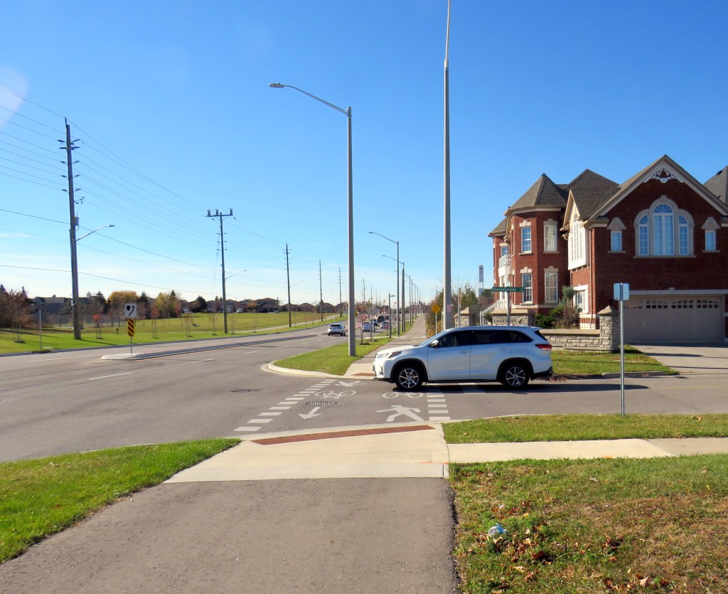
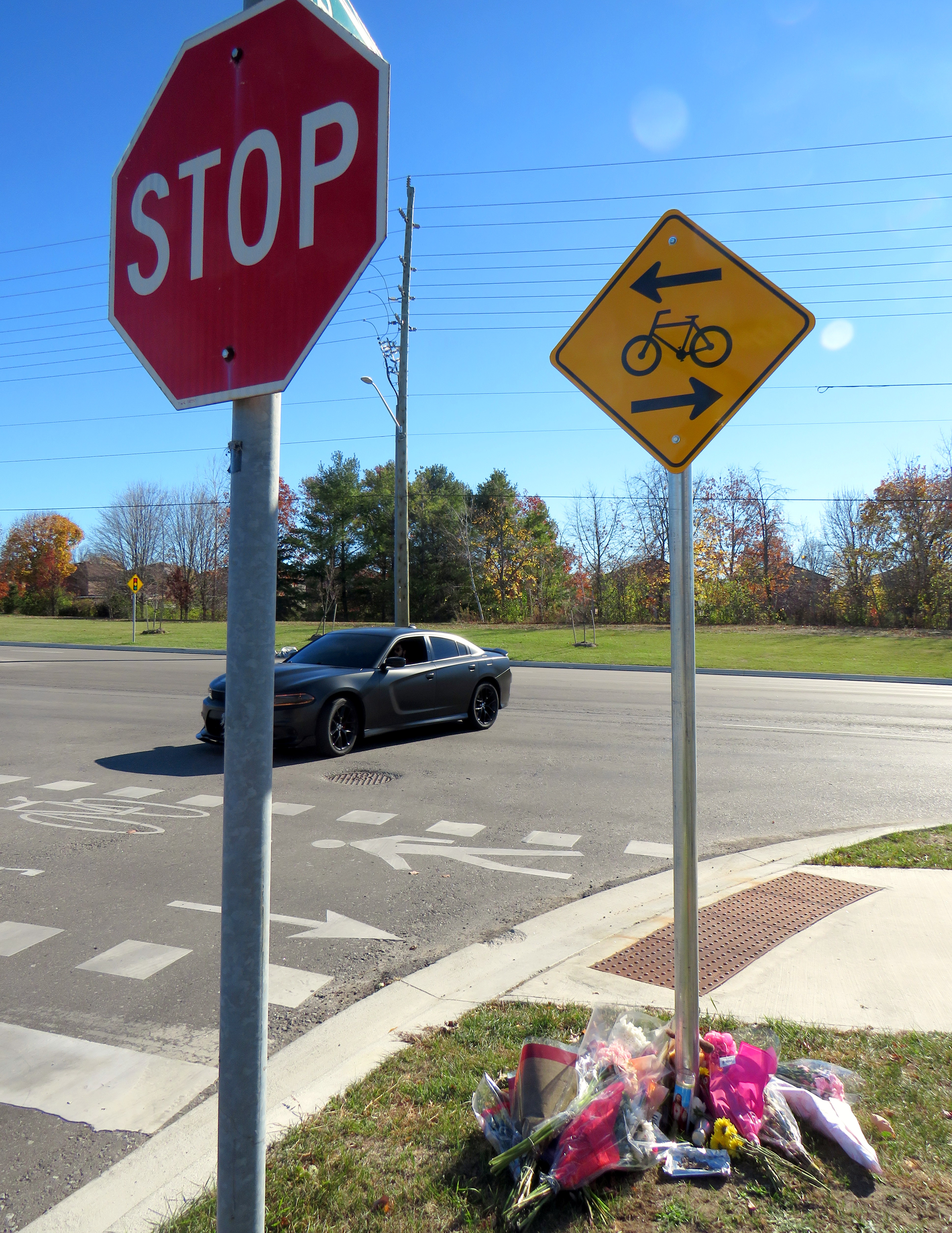
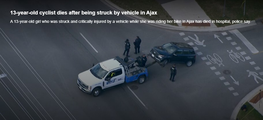
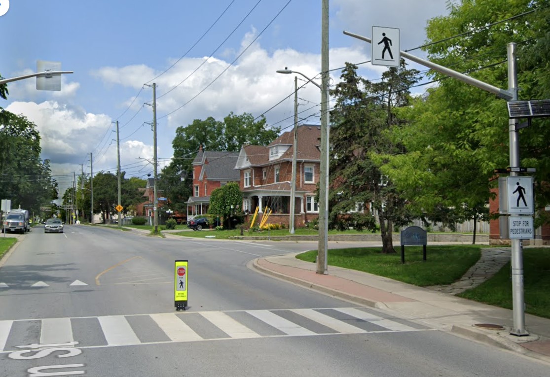
On Thursday, November 7, at approximately 7:35 AM, a 13-year-old girl was struck and killed by the driver of a Hyundai Santa Fe (a midsized crossover SUV) at Rossland Road and Stevensgate Drive. The girl was riding a bicycle in a marked crossride, a crossing designated for both pedestrians and cyclists along a multiuse path, when she was struck and pinned beneath the vehicle.
Multiuse paths (MUPs) are typically found in parks, particularly along waterbodies such as lakes, rivers, and creeks such as Lake Ontario or the Don River. They are shared by all sorts of people, including walkers, runners, cyclists, dog-walkers, rollerbladers, and wheelchair users, often coming into conflict on busy, narrow sections such as the Martin Goodman Trail or the Lower Don Trail.
In the suburbs surrounding Toronto (and in a few locations within the city, such as on Lake Shore Boulevard East and Eglinton Avenue West), MUPs are a popular form of cycling infrastructure along busier roads with higher speed limits. Older boulevard MUPs required cyclists to stop and dismount at road crossings (though these instructions were usually ignored). Newer and upgraded MUPs allow cyclists to ride across intersecting roadways, at marked crossrides. Signage advises motorists to watch for cyclists and advises cyclists to slow and watch for motorists and to yield to pedestrians. At signalized intersections, most new MUPs include dedicated bicycle signals.
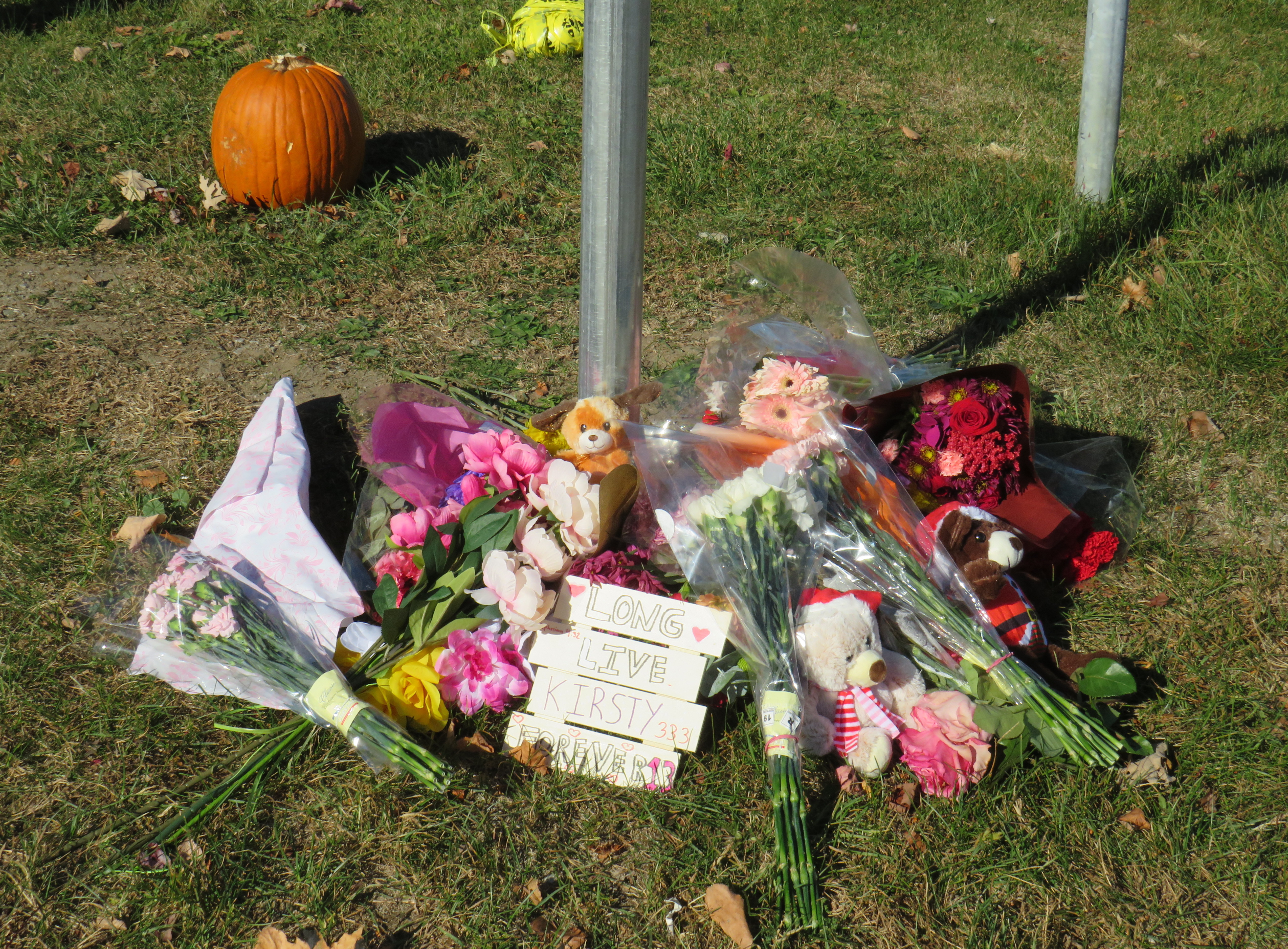
It was at one of these new crossrides that Kirsty was struck and killed. Though no official police press release or any follow-up news articles provided the girl’s name, that name was clearly visible at the makeshift memorial next to where she was killed.
Crossride at Stevensgate Drive, where a driver pulled out ahead into the crossride without stopping at the stop sign/stop line first.
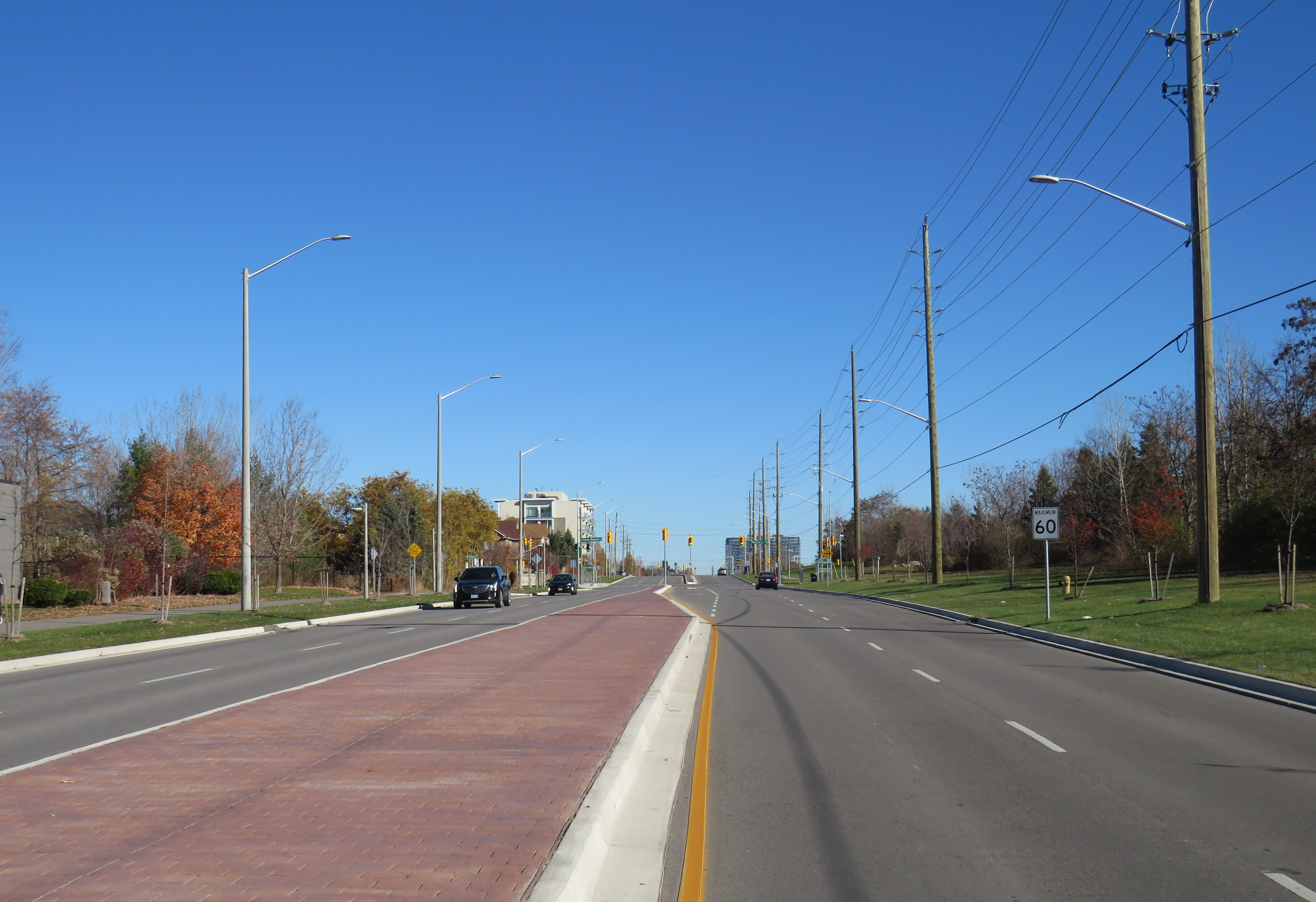
Rossland Road was recently widened from two to four through lanes; a new multiuse path was built on the north side of the roadway, complete with crossrides and cyclist signals. Rossland Road is very much a road. There are no houses fronting onto the roadway, while the few driveways on Rossland provide access only to church and commercial plaza parking lots.
Rossland Road in Ajax has two lanes in each direction, with a concrete median in between. The speed limit on Rossland is 60 km/h.
Stevensgate Drive, which leads north from Rossland Road, is a quiet residential street with about two dozen homes and an evangelical church. A stop sign controls traffic at Rossland Road. Though Stevensgate connects to a large subdivision to the north, there are several other streets with signalized intersections that also provide access to the community.
Motorists take wide turns pulling into Stevensgate Drive
When Kirsty was struck, it was by the southbound Santa Fe driver who would have passed a stop sign and a clearly painted stop line before entering the crossride. A CP24 news report clearly showed the vehicle being towed onto Rossland Road from the southbound direction. At 7:35 AM, it was daylight.
Drivers rolling through stop signs are a common occurrence, even though the law clearly states that a full and complete stop at the stop sign and painted stop line is required before proceeding. Had the driver done so, this tragedy most likely would have been prevented.
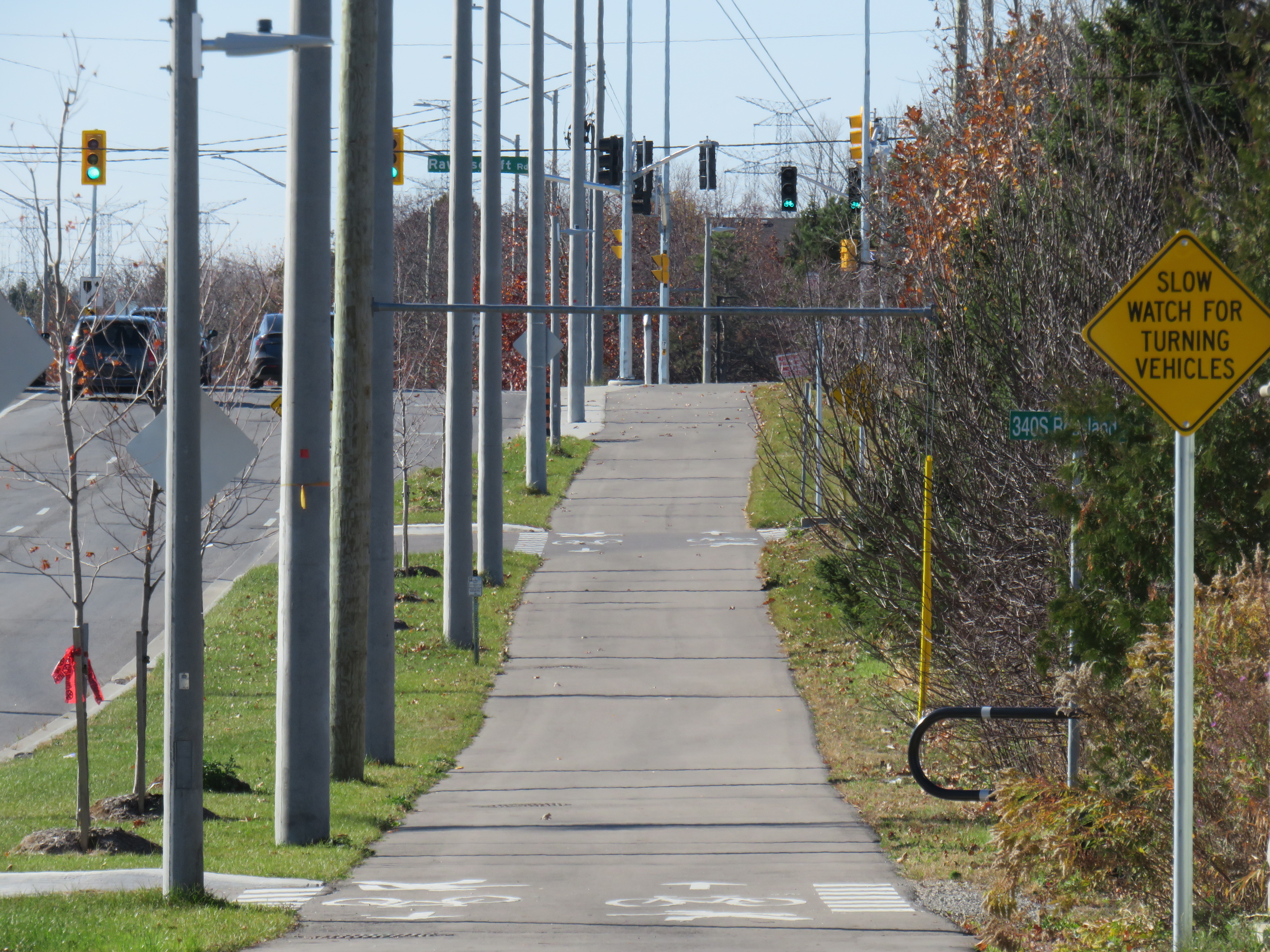
Looking west along the multiuse path, towards Ravenscroft Road
Two days later, on Saturday, November 9, I visited the scene. I noted the roadside memorial next to the stop sign facing Stevensgate Drive. While I was there, several people stopped to visit the memorial; at least two people left flowers and cards of sympathy.
While there, I mounted a small digital camera on the trunk of a car parked on the west side of Stevensgate, about 75 metres north of the intersection, in a legal parking spot. The camera, mounted on a mini-tripod, was mostly inconspicuous. Within 25 minutes, five motorists improperly stopped after the stop line and into the crossride; two properly stopped before creeping up to make their turn. Two drivers also made fast, wide right turns into Stevensgate during that time. The edited video below shows motorists’ actions during that 25 minutes
Video taken on Saturday, November 9 showing motorists driving south on Stevensgate Drive towards Rossland Road(3 minutes, 7 seconds)
While taking photographs and recording the videos, a resident, who lived a few houses north of the intersection, came to talk to me, and asked if I knew the girl. I explained why I was there, and we had a short, but good chat, about the collision and road safety. He noted that it is hard to see traffic from the stop line, and that he has to pull forward before turning. But he agreed that the stop line was there for a reason, and that drivers often rush to get onto Rossland.
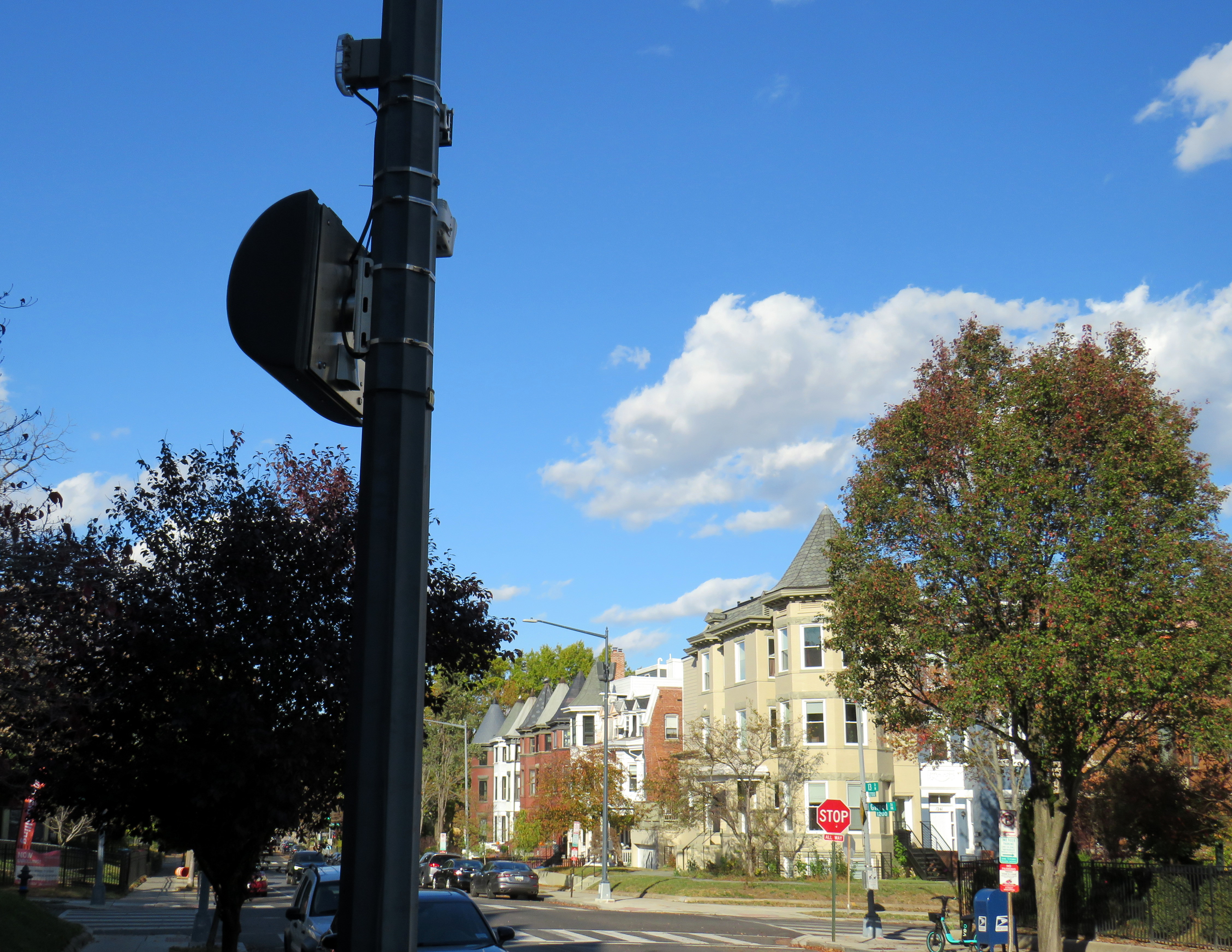
In Washington DC, there are stop sign cameras mounted at specific locations, though there are only about a dozen of those throughout the city at any given time. These could provide a useful tool for targeted automated enforcement on Ontario’s roads to reinforce proper driving behaviour.
A pole-mounted camera faces an all-way stop in Washington DC
Intersections should also be redesigned to improve the visibility of pedestrians and cyclists at crosswalks and crossrides and act to slow down motorists; raised sidewalks and path crossings would act as a speed hump as well as enhance visibility. A concrete island or short median at the stop sign would force motorists to approach the stop at a slower speed and prevent wide turns on to and off the intersecting street. A quick and inexpensive (though less-effective) solution could be to place wide knock-down bollards with supplemental crossing and stop sign messages in the middle of the roadway at each stop bar and crosswalk/crossride. Though this is best as a short-term measure.
As the provincial government vindictively overrides municipalities’ ability to provide safer on-road cycling infrastructure, off-street infrastructure, such as MUPs, will remain an important tool for promoting active transportation, especially in suburban areas and high-traffic neighbourhoods. Though boulevard MUPs provide separation from traffic in most cases, they are particularly hazardous at intersections, especially when motorists are distracted, aggressive, or just merely careless. There is much more that can and should be done to make them safer for all road users.
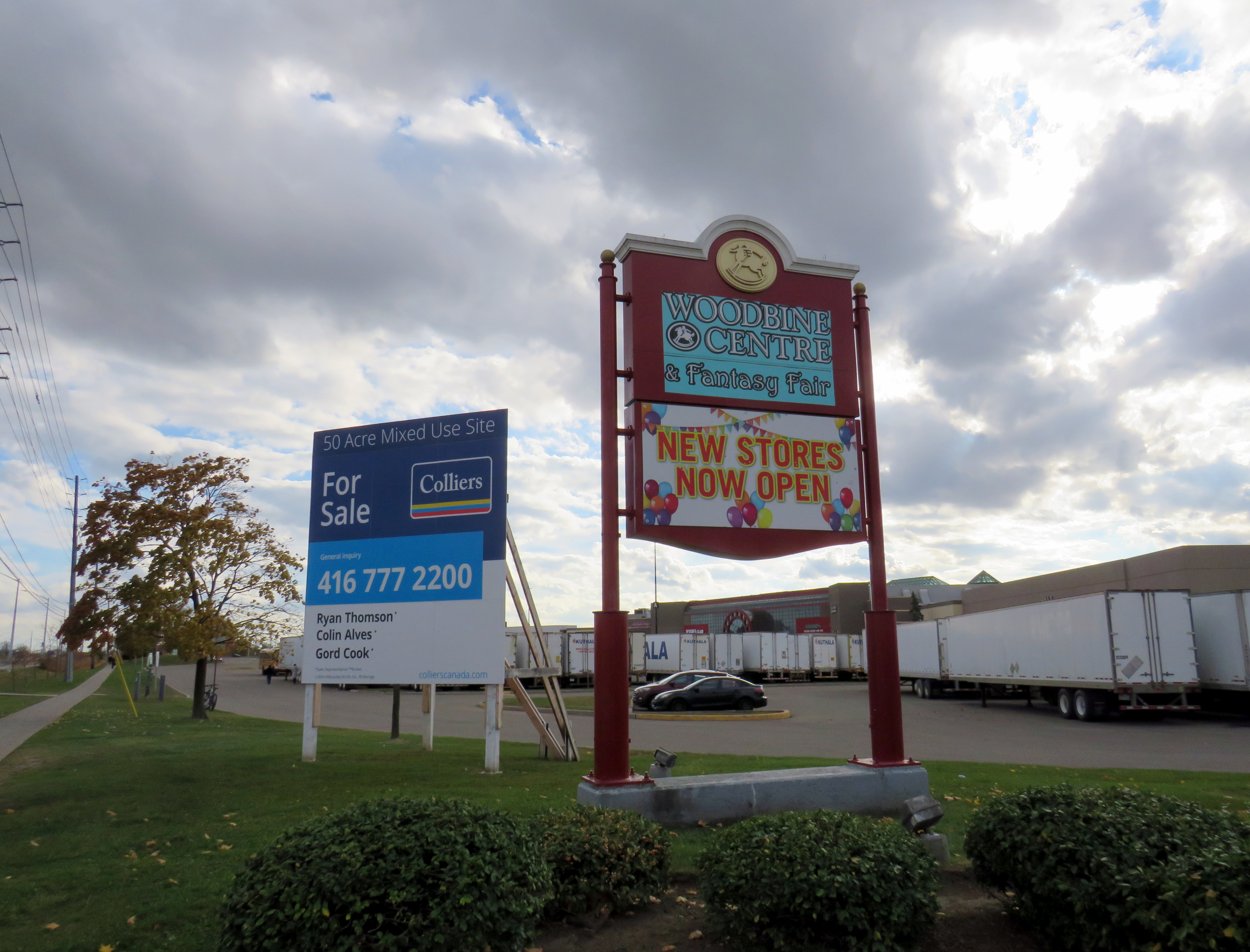
Woodbine Centre & Fantasy Fair is up for sale, again
Growing up in Brampton in the 1980s and early 1990s, there were two favourite day trips I fondly remember.
There were the drives to nearby Georgetown, which had one of the largest indoor playgrounds at any McDonald’s restaurant. It featured a multistorey indoor crawl maze, a spiral slide that led to a giant ball pit, a tire swing, as well as a standard McDonaldland-themed merry-go-round. A CN caboose could be rented for children’s parties. At least we’d burn off some of the calories from the burgers and fries. (There’s a video on Reddit from 1992 that shows what it looked like.)
Then there were the trips to Fantasy Fair. When Woodbine Centre opened in 1985, it featured a unique attraction: a large indoor amusement park, complete with a historic Looff carousel (though with replica fiberglass horses), a Ferris wheel, and a train ride that wound through the attraction. The highlight for me, however, was a huge indoor playground that spanned two floors that was many times the size of the Georgetown McDonald’s playground. It had multiple slides, a mirror maze, swings, and two ball pits. There was also a McDonald’s restaurant facing Fantasy Fair, in one of the faux-Victorian storefronts that surrounded the attraction.
Fantasy Fair Carousel, November 2024
The mall itself was anchored by The Bay and Simpson’s, along with a Cineplex multiplex cinema, and a complete assortment of mid-market retailers. In 1991, when the Hudson’s Bay Company retired the Simpson’s brand (converting most of those stores into The Bay), it sold the redundant store to Sears Canada. A Zellers discount department store was added in the 1990s. But the mall slowly lost its pizzazz.
Cadillac Fairview sold Woodbine Centre in 2005 to a numbered company, with real estate management firm Avison Young operating the mall. By then, many of the national retailers had left once their leases were up. The mall’s relatively isolated site, without good transit access became a liability. Changing demographics in northern Etobicoke, competition from surrounding larger malls (Bramalea City Centre, Sherway Gardens, Square One, Vaughan Mills, and Yorkdale) and new big box retail developments also took their toll.
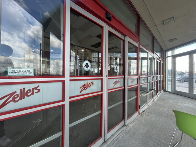
The Zellers store was not one of the leases picked up by ill-fated Target Canada, and it closed in 2012. Sears closed in March 2017, a few months before the entire chain was liquidated. Sport Chek closed its store in 2018.
Woodbine Centre’s Zellers store was not picked up by Target, and the parking lot-facing doors still have the defunct retailer’s logo intact
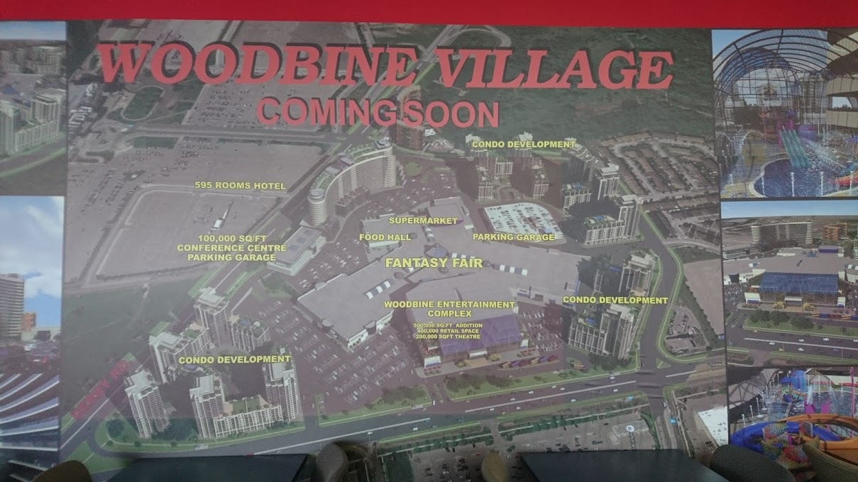
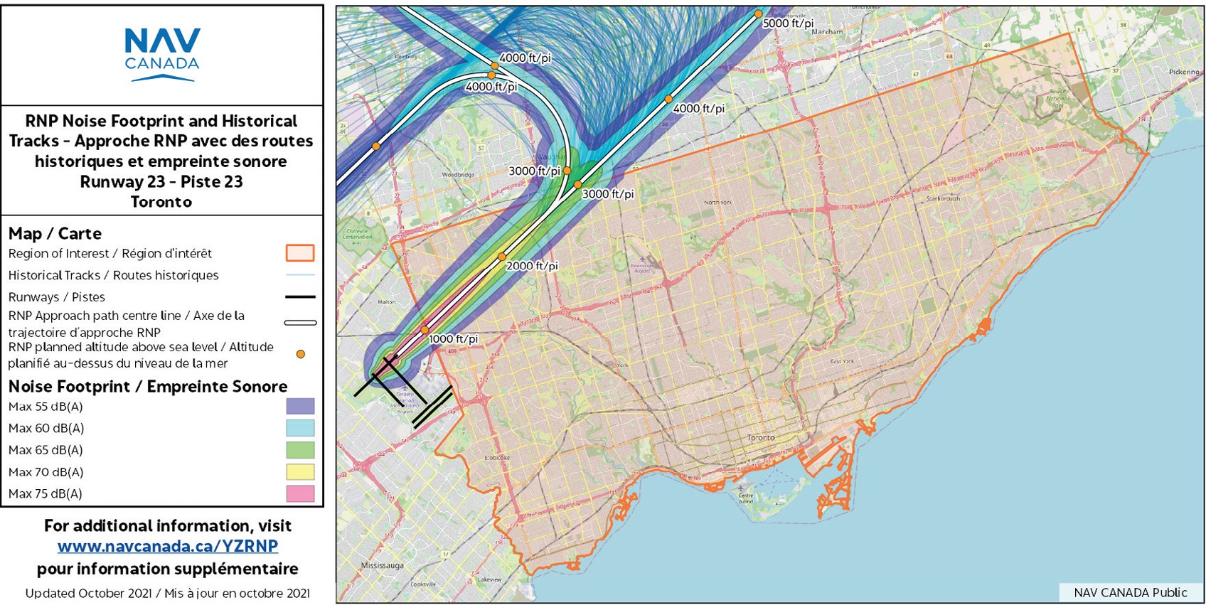
There was an attempt to renovate the mall, as part of a grand plan to revitalize the property with a new supermarket, refreshed food court, new entertainment options, and condominium towers surrounding the shopping centre. The Woodbine Village proposal competed with the better-financed Woodbine Live plans at the nearby racetrack, which included a casino, hotel, and event hall, all of which were built or are nearing completion. Condominium development is complicated as the property, particularly the southeast corner at Highway 27 and Rexdale Boulevard, is directly below the approach for Pearson Airport’s Runway 23.
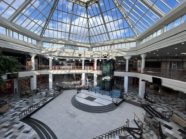
Poster promoting “Woodbine Village” which boasts a new supermarket, condo development, hotel, and expanded Fantasy Fair including indoor waterpark NAV Canada map showing approach and noise contours for Runway 23, which passes directly above Woodbine CentreWoodbine Centre’s central atrium, including defunct fountain below glass elevator
After a disheartening American election result on Tuesday, November 5, I decided to turn off the newsfeeds, and out for a walk and explore Woodbine Centre again.
Though the basic architecture remains intact, the corridor floors were given cheap new brown, grey, and beige tiles that look out of place in the post-modern interior. Much of the original green paint on the roof, walls, railings, and signs is now red and mahogany.
Apart from the fast food offerings, there were few recognizable store names among the tenants in 2024. Apart from Hudson’s Bay, Foot Locker, Ardene, The Children’s Place, Dollarama, LensCrafters, TD Bank, and Urban Behavior, most stores were independent clothing, home décor, and furniture stores, or were cellphone vendors such as Wow Mobile, Best Buy Express, or Rogers and Bell kiosks. About 20 percent of the store fronts were vacant.
Looking towards the old Sears store, which is now All Home Furnishings, which was having a clearance sale in November. Note the Payless Shoe Shack, a knock-off of the defunct Payless Shoe Source chain, on the left. Vacant faux-Victorian storefronts at Fantasy Fair
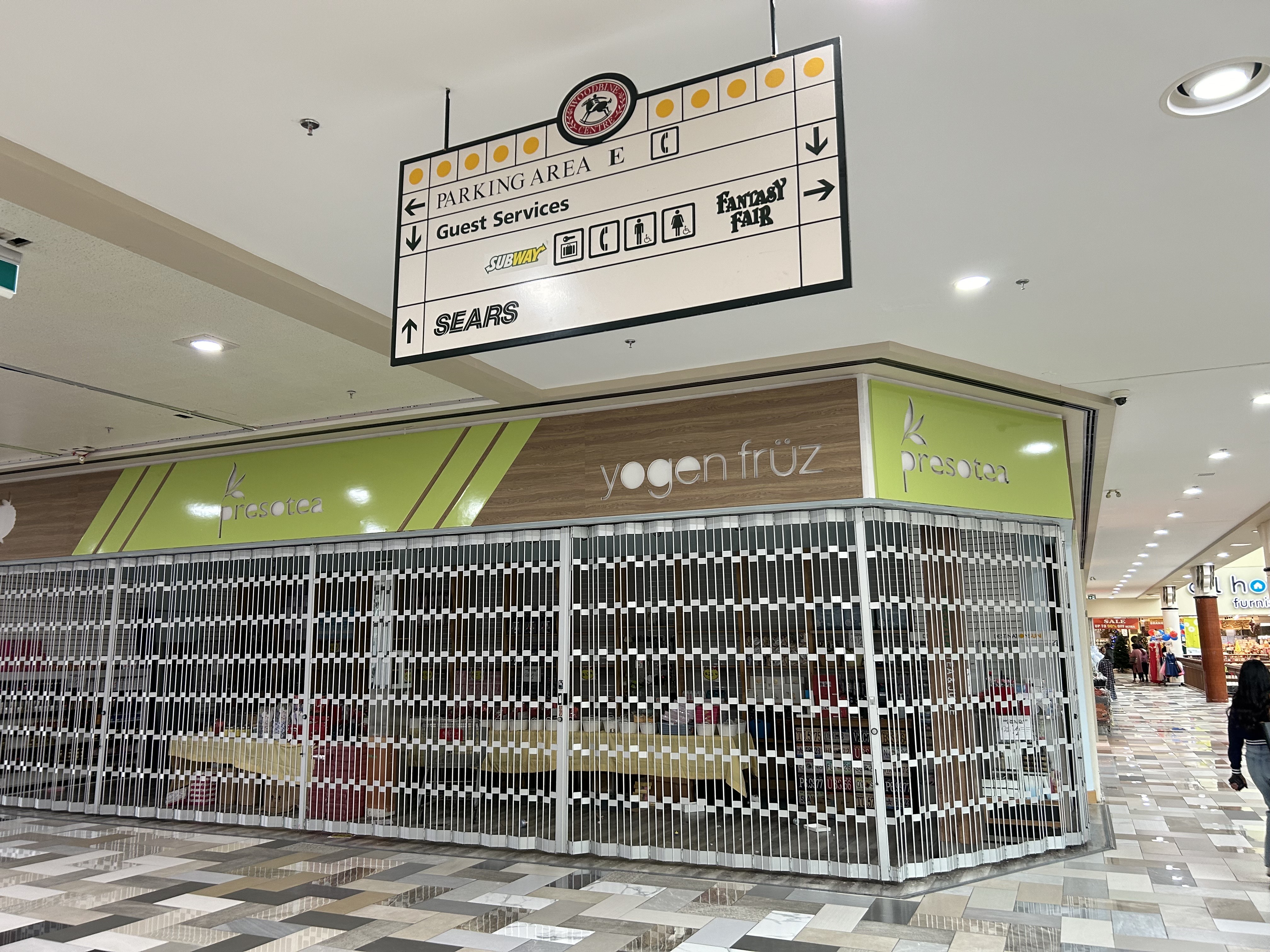
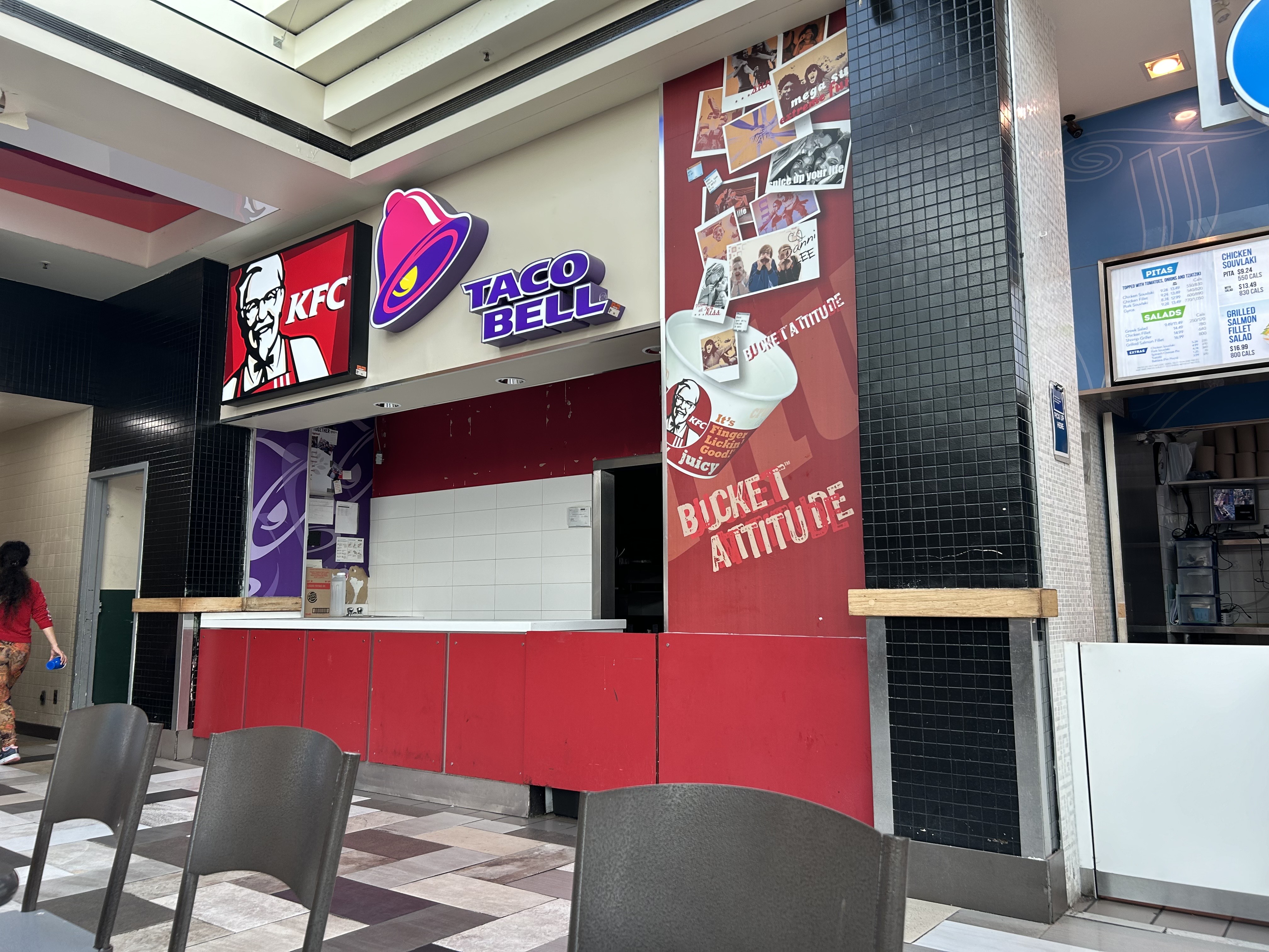
Professional property managers are quick to update signage and keep up appearances; the management at Woodbine has clearly given up. Vacant storefronts are left exposed, rather than blocked off. Signage advertises stores that are long gone. Pot lights flicker on and off.
Overhead sign pointing the way to Sears, which closed over seven years ago. The Subway restaurant is also gone. Behind the sign, a shuttered Yogen Fruz/Prestotea store front acts as storage. A closed KFC/Taco Bell stall in the food court, with the signage still up and illuminated, despite the equipment taken out
Surprisingly, Fantasy Fair was still operating, even on a Wednesday afternoon where there were few visitors. Ride attendants, dressed in red vests, looked bored, even when running the train for the lone parent and child. The Ferris wheel is now permanently closed, however, and some of the attractions look sadly decrepit.
The railway crossing lights, bells, and gates still work at Fantasy Fair when the train passes through
Outside the mall, much of the parking lot is fenced off and is now used for truck and trailer storage, and the storage of overflow rental car fleets. Though the rental car parking began during the COVID-19 pandemic, when people stopped travelling, it continues to be an easy revenue stream for the mall management. The truck trailers, on the other hand, are an unsightly feature, particularly where they face Highway 27.
Fenced-off rental cars in the Woodbine Centre parking lotTruck trailer parking on part of the mall parking lot
Unfortunately, the future is not good for Woodbine Centre as a mall. Though mixed-use development remains a possibility — Humber College is within walking distance — the airport noise will continue to be a challenge for condominium sales. Transit expansion would certainly help; the nearly-complete Finch West LRT terminates nearby. Extending that two kilometres south to serve Woodbine Centre, Woodbine Racetrack/Casino, and a planned GO Transit station, could be the boost the site needs. (Of course, the mall site could have made a good location for a mega-spa, particularly with the nearby casino venue and hotels, but I digress.)
The Humber College LRT terminus is less than a kilometre north of Woodbine Centre
The mall’s fate will likely be decided soon. The site is up for sale again, not advertised as a shopping centre, but as a “50 acre mixed use site.”
1992 Tenants
Below is the list of tenants at Woodbine Centre in 1992, obtained from the 1993 Canadian Directory of Shopping Centres, published by Maclean-Hunter. Tenants still open in 2024 are bolded.
Anchors Anchors: The Bay (140,000 sq.ft.), Sears (135,000 sq.ft.)
Fashions and footwear Children’s Wear: Flora’s, Just Kids. Family Wear: Cotton Ginny. Ladies’ Wear: Addition-Elle, Antel’s, Au Coton, Braemar, Braemar Petites, La Cache, The Cavery, Cotton Plus, D’Allaird’s, Dalmy’s, Emotions, Fairweather, Irene Hill, Jacob, La Jolie, Karuba, Lady Foot Locker, Limité, Lindor, Liz Porter, Mia, Northern Reflections, Ports International (Ladies), Reitmans, Ricki’s, Shirley K Maternity, Smart Set, Suzy Shier, Tabi International, Tan Jay, Tristan, Tucci Fashions. Menswear: Casa Angelo, Petrocelle Vomo, Randy River, Star’s Men’s Shop, Steel, Tip Top, Tuxedo Royale.
Unisex / Men’s & Ladies’ Wear: Benetton, Boca, Bootlegger, Canary Island Adventure & Travel Company, Le Château, Frenz Leather, Jean Machine, Levi’s 1850, Pantorama, The Pro Image, Stitches, Thriftys, Willow Ridge. Footwear/Leather Goods: Agnew, Aldo, Bata, Belinda & Brother, Bentley Leathers, Calderon, Florsheim Shoes, Foot Locker, Fredelle, K. Jamson, Kinney, The Little Shoemaker, Moneysworth & Best, Naturalizer, Pegabo Jewellery/Fashion Accessories: Accessories For You, Ardene, The Joy of Sox, Mappins, Peoples Jewellers, Reflexions, Young’s Jewellers
Other retailers Books: Classic Bookshop, Coles, Moyer’s The Teacher’s Store, Smithbooks Cosmetics/toiletries: Body Reform, Caryl Baker Visage, Enchante Perfumes, Merle Norman Cosmetics Department store/mass merchandiser: Marks & Spencer Drugs/health & beauty: Shoppers Drug Mart Electronics/Computers: Bell Canada Phone Centre, Compucentre, Majestic Sound Warehouse, Radio Shack, Safe & Sound Fabric & Sewing: Needle ‘n’ Thread Florist/Nursery: Woodbine Florists Furniture & Furnishings: Brass Imports, Clocks Unlimited, Diamond Furniture, Lighting Unlimited, Pictures Gift: A. David Soloway, China Panda, Den For Men, Jinny’s China & Gifts, Party Hut, Rafters, Le Roulet Grocery: Bulk Barn Hardware/Paint & Paper: St. Clair The Paint & Paper People Hobby/Craft: Lewiscraft Housewares: House of Knives, Pot Pourri, Shaver Centre Fine Blade, Stokes Music/Records & Tapes: A&A Music & Entertainment, Discus, Music World Optical:LensCrafters Pet: Aquarium Toronto Photo/Camera: Blacks, Japan Camera Restaurant and Fast Food: A & W, Abacus Cuisine, Baby O’Donuts, Dutch Treats, Jimmy The Creek, J.J. Muggs, Kentucky Fried Chicken, Kernels, London Style Fish & Chips, Los Rios, Made In Japan A Teriyaki Experience, Manchu Wok, Manfreds, McDonald’s, Mr. Submarine, New York Fries, Sbarro. Specialty Food & Drink:Baskin-Robbins, Laura Secord Mrs. Fields Cookies, mmmarvellous mmmuffins, Swiss Fudge, Timothy’s Coffees of the World, Yogurty’s Yogurt Discovery. Stationery/Card: Garfield, Grand & Toy, Hallmark. Toy: Toy World. Variety/Convenience: The Silver Dollar Store, United Cigar Store. Dry Cleaners: Parker’s Cleaners. Financial/Legal: Bank of Montreal, Canada Trust Hairstyling/Esthetics: The Cut Above, Da Vinci, Tantastic, You’nique Hairstyling. Medical/Dental: Eye-Exam Centre, Procare Medical Centre, Woodbine Dental. Printing: K.P. Copy. Theatre / Entertainment: Cineplex, Orville & Wilbur Family Games, Wizard’s Castle Travel: Marlin Travel Miscellaneous: Lottery Kiosk
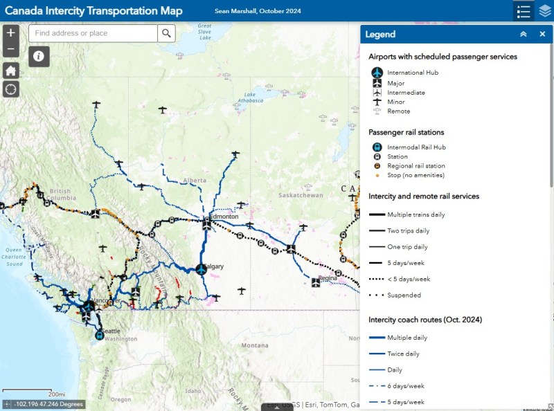
There are buses to more destinations in 2024, but a few major gaps persist
NOTE: Previous versions of the Ontario and Canada maps are retired; please see the new Canada Intercity Transport Map, launched March 30, 2025. This will now be the only interactive map that I will update.
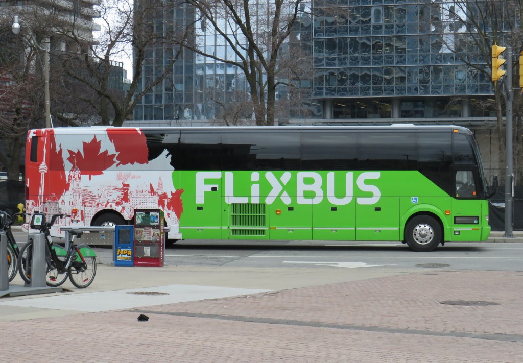
Unfortunately, outside of Ontario, there not that many updates to make. On Vancouver Island, at least, there is now daily service all the way to Port Hardy in the north and Tofino and Ucluelet to the west, with additional runs between Comox, Nanaimo, and Victoria. There are more buses between Vancouver and Seattle; FlixBus is now operating on the busy Calgary-Edmonton and Calgary-Banff routes. There is also a new twice-weekly Edmonton-Camrose service, thanks to work by the University of Alberta’s student union; it partnered with FlixBus to provide the service.
Also new to the map is Mountain Man Mike’s bus service between Vancouver, Nelson, Kaslo BC, and Calgary, as well as Mobilité Charlevoix, a regional service that connects several towns east of Québec City including Baie-Saint-Paul, La Malbaie, and Clermont.
Unfortunately, several wide gaps remain. Despite plenty of competition on the busiest routes in Southern Ontario and Alberta, there is no bus service between Calgary and Regina, leaving cities like Medicine Hat and Moose Jaw without intercity connections, apart from airport shuttle services, despite once-frequent Greyhound service. Between Winnipeg and Regina, it is still just one bus a week. Maritime Bus, for whatever reason, still has not restored service across the New Brunswick-Québec provincial line.
Without comprehensive government-led coordination and support, these gaps are likely to remain unfilled.
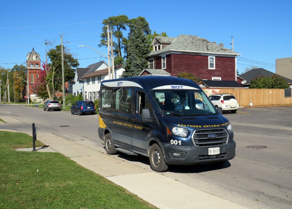
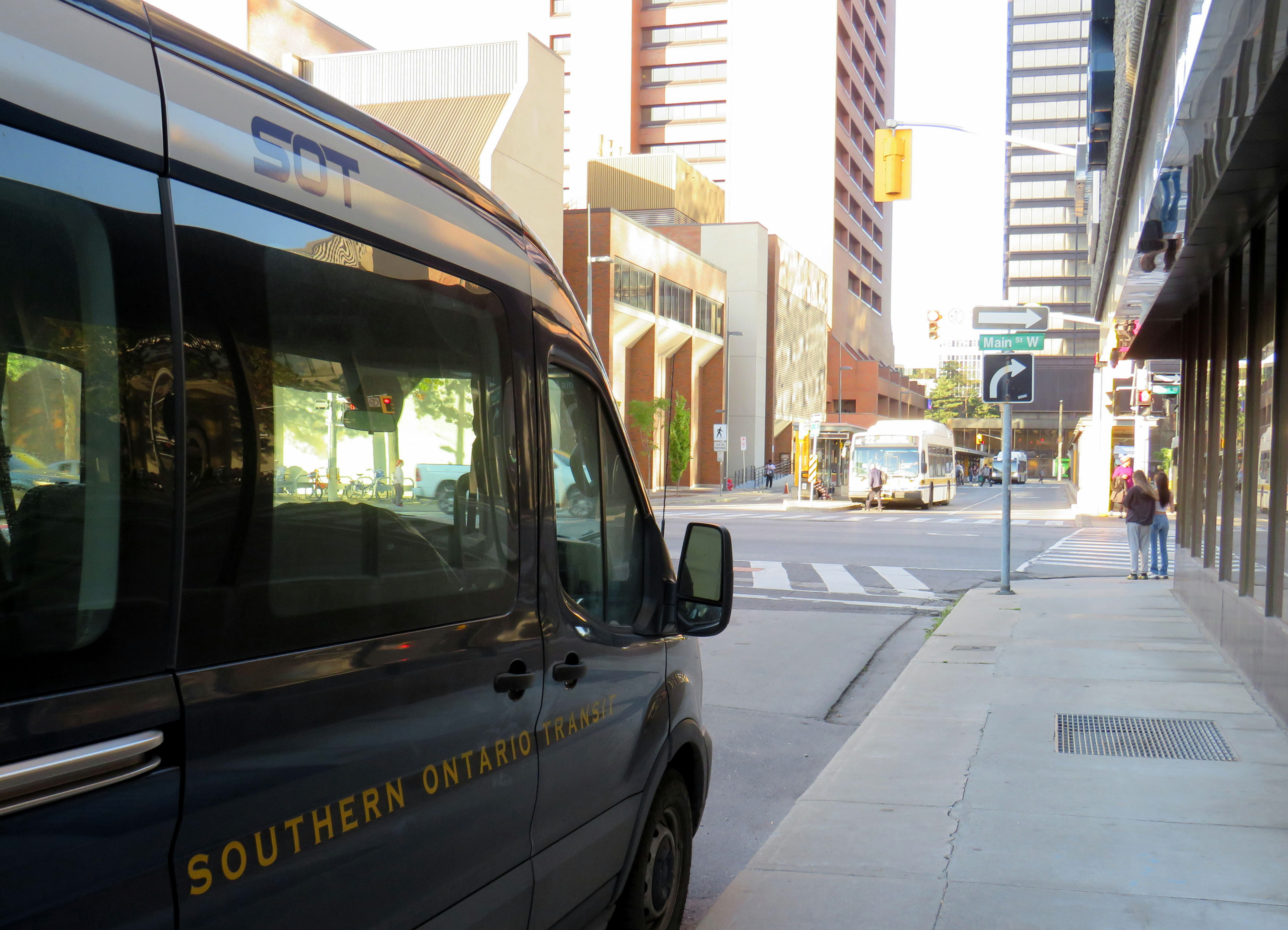
Southern Ontario Transit minibus in Dunnville, October 2024
Earlier in October, I got to meet Rae Rivard, owner-operator of Southern Ontario Transit (SOT), a new intercity transit operator currently serving Hamilton and Haldimand County. The route, which launched on September 16th, offers three weekday round trips between Downtown Hamilton and Dunnville, serving the communities of Caledonia, Hagersville, and Cayuga.
Haldimand County, along with the neighbouring Six Nations and Mississaugas of the Credit First Nation reserves, remained unserved by intercity or local bus services since the early 2000s; in 1990, United Trails operated a daily bus between Port Dover, Hagersville, Caledonia, and Hamilton. Cayuga and Dunnville were served by a Greyhound route on Highway 3 between Niagara and London. More recently, as Niagara Region was building a regional transit service and Norfolk County successfully applied for provincial funding for a new service between Simcoe and Brantford, Haldimand County refused to take part. Enter SOT.
SOT, which charges a $10 one-way fare, operates without the support of the municipal government, and is unable to put up bus stop signs or actively promote its service at municipal facilities such as libraries or community centres. For this reason, ridership remains low, despite growing populations in Caledonia and Hagersville and convenient links to Hamilton Airport, Mohawk College, St. Joseph’s Hospital, and to GO Transit and HSR services.
Rivard will tell you that “the primary challenge we face today is slow uptake. Due to a number of limitations and challenges currently out of our control, the number of regular and new riders trends up every week, but not as fast as we need to cover expenses…. Many of the limitations we are dealing with right now can easily be addressed at no expense, but these choices are out of our control.”
Rivard reached out to businesses and social service organizations, but was turned away, adding that “the entire operation has been entirely funded out of me and my wife’s savings, and we are really struggling to keep up with expenses at this rate.”
Without approved bus stop locations with curb access, SOT is not able to provide fully-accessible service, though it already has a wheelchair-accessible vehicle. The lack of physical bus stops and publicity has made it difficult to attract riders, though while riding with Rivard on a beautiful October afternoon, it was clear that a demand exists as several residents came up to the minibus to find out more information.
My hope is that word spreads about this unique and essential operation and that the local communities provide the needed support to make this service work. If this initial route succeeds, SOT would like to expand service in Haldimand and take on other gaps in the Ontario network.
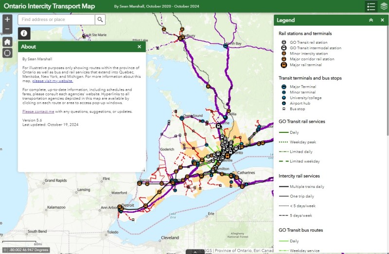
I updated my Ontario Intercity Transport Map to add Southern Ontario Transit’s route. Commuter Connect in Northumberland County ended service not long after VIA Rail finally resumed its early morning train from Kingston to Toronto. East Zorra-Tavistock Transit in Oxford County did not last long either, and service there has ended.
Added to the map:
Southern Ontario Transit between Hamilton, Caledonia, and Dunnville
Red Arrow’s daily Toronto-Western University express, which replaces its Toronto-Niagara Falls run
A new daily Flixbus route between Toronto, Hamilton, and St. Thomas
A new OnexBus route between London, Goderich, and Port Elgin, operating Friday through Monday
OnexBus’s London-Pearson Airport-Brampton route, which operates several trips a day
Ourbus’s Toronto-Ottawa route
Kasper’s daily Winnipeg-Kenora-Sioux Lookout service
Revisions to on-demand services in Niagara Region
Some revised routings and service levels across the province
Removed from the map:
Commuter Connect in Northumberland County
East Zorra-Tavistock Transit
Kasper’s on-demand service to Red Lake/Balmerton
Though it is good to see Bruce County — particularly rapidly growing Saugeen Shores — get another link, that part of Ontario is still poorly served; there should be daily services between larger Bruce County communities like Saugeen Shores, Kincardine, and Walkerton at least to Owen Sound and Hanover. Lindsay is also left without any intercity services, after TOK ended service from Toronto to Haliburton last year. where a Peterborough-Lindsay-Pontypool service, perhaps extending to Durham College/Ontario Tech University in Oshawa could prove to be a very useful route.
If you like this post and you would like to help out with my online mapping and webhosting costs, consider buying me a coffee.Thank you!
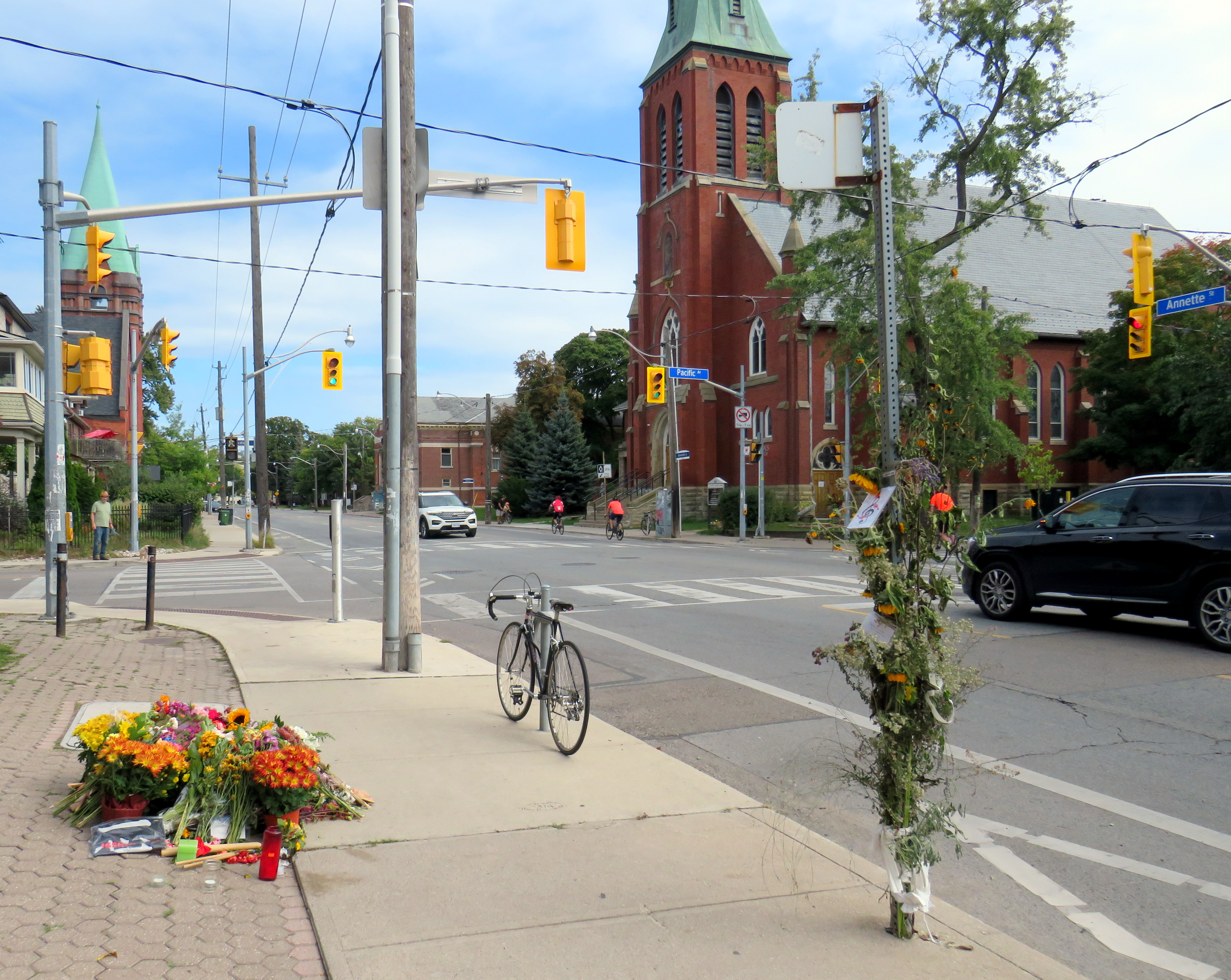
On Monday, September 23 at 8:06 PM, the driver of a 2024 Hyundai Elantra sedan travelled north on Pacific Avenue. The driver of a 2017 Hyundai Tucson crossover SUV drove west Annette Street. The two vehicles collided in the intersection with enough force that the Tucson continued into the sidewalk on the northwest corner, striking two pedestrians. A man, aged 50, was injured and taken to hospital. Julia Cleveland, 46, died at the scene.
As of Thursday, October 3, charges have yet to be laid.
Looking west on Annette Street towards Pacific Avenue
On Saturday, September 29, I paid a visit to Annette and Pacific. A roadside memorial of flowers, cards, and tributes were laid next to the sidewalk where she and a fellow pedestrian were struck. I also took note of the streetscape, the surroundings, and driver behaviour on a Saturday afternoon.
While at the intersection, I observed many examples of distracted, aggressive and inconsiderate driving, as the video compilation depicts. Drivers intentionally drove through stale amber and solid red lights, blocked crosswalks, and swerved around slower vehicles. These motorist behaviours are commonplace.
Video shows driver behaviour at Annette Street and Pacific Avenue
I also noted many pedestrians and cyclists. There’s a No Frills grocery store on Pacific Avenue between Annette and Dundas. Two blocks east, there’s a Toronto Public Library branch. There were several families with young children, as well as older pedestrians.
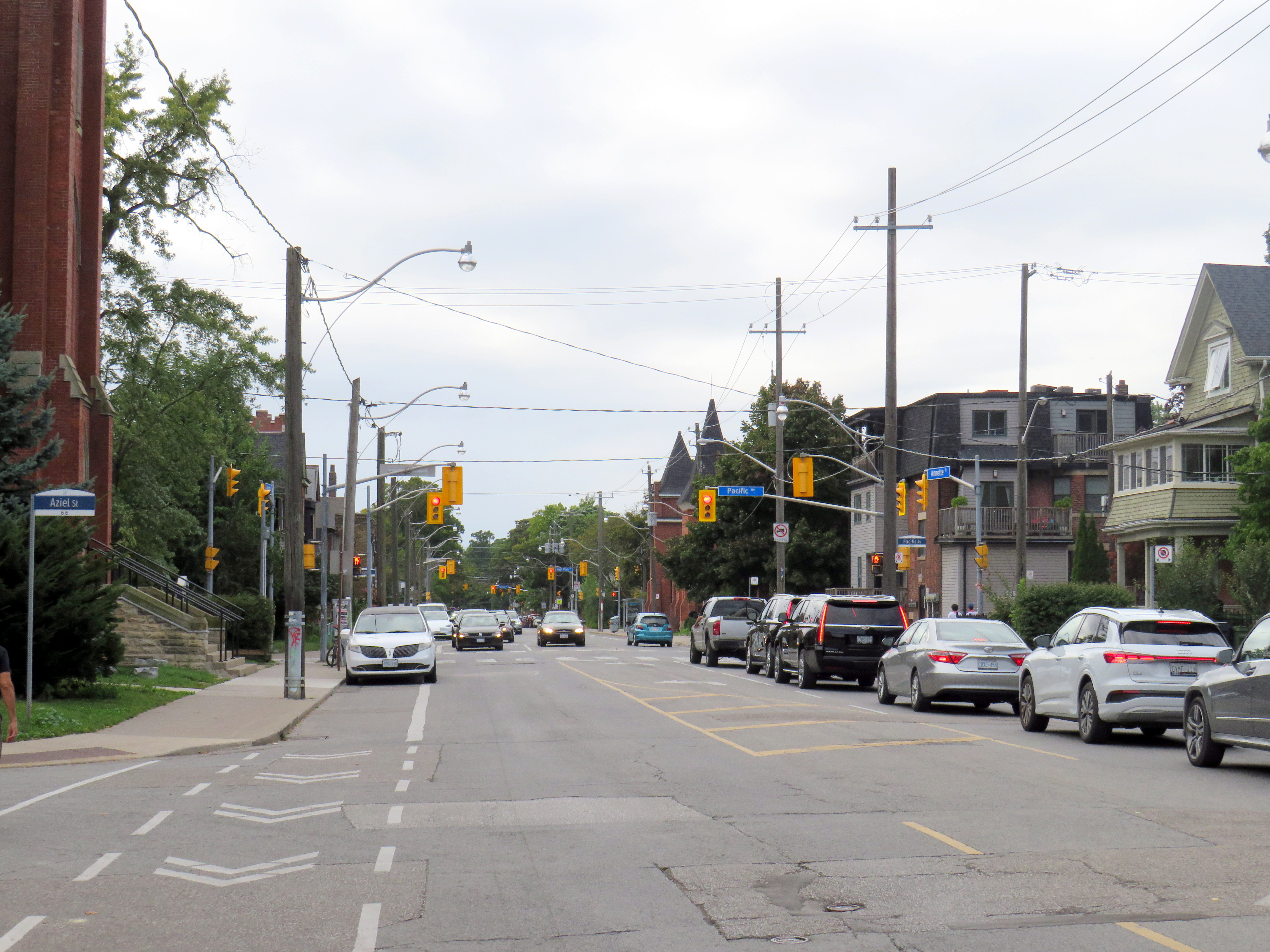
In 2008, Annette Street was reconfigured from a four-lane cross-section to include bike lanes and centre left turn lanes. Though it is a busy east-west cycling route, connecting to bike lanes on Dupont Street and Runnymede Road, the lanes are unprotected and are only marked with solid white lines and signage. The limited protection offered to cyclists was made clear when a stretch Lincoln limousine pulled out front of St. Cecilia’s Catholic Church and idled in the bike lane for over 30 minutes. Though the driver was likely waiting out front for a wedding party to emerge, I noted at least two dozen cyclists forced to merge into traffic to get around it.
Cyclists merging around a limo idling in the unprotected bike lane
The intersection itself offers minimal protection to pedestrians. Sidewalks are flush against the roadway, with very shallow curbs. There are unnecessarily wide turning radiuses at intersections. On the northwest corner of Pacific and Annette, there are metal bollards, but they are positioned to protect the small apartment building, not the sidewalk itself.
Looking east on Annette from Pacific Avenue. On the right is St. Cecilia’s Catholic church, beyond is a masonic lodge and a Toronto Public Library branch
Annette and Dupont Streets make up a useful bypass around traffic on Bloor Street to the south. There are three blocks between Pacific Avenue and the first traffic signals to the east, at Keele Street. To the west, however, there are traffic signals at the next three intersections: at High Park Avenue, Quebec Avenue, and Clendenan Avenue. Motorists might be tempted to speed through amber and red signals. Without better protection — protected bike lanes, for example, pedestrians and cyclists are especially vulnerable. Despite the 2008 road diet, the roadway has not been significantly altered.
A few days later, on Wednesday, October 2, there were two more collisions in which drivers struck pedestrians at signalized intersections, at Avenue Road and Davenport Road in Midtown Toronto, and at Islington Avenue and Finchley Road/Odell Avenue in central Etobicoke.
At Avenue and Davenport Roads, a pedestrian was struck when the drivers of three cars collided. One vehicle, a Mercedes-Benz SUV, stopped on the sidewalk after hitting a concrete pole.
Pedestrian seriously injured at Avenue Road and Davenport. Road safety improvements on Avenue Road are scheduled to start soon, which unfortunately was not soon enough to prevent another injury. Via@ARSCSafetyhttps://t.co/CspQr8isoZpic.twitter.com/MqppOVd2PV
In Etobicoke, a family of five were struck by a left-turning motorist turning from Finchley Road south onto Islington Avenue. The driver, a 77-year old woman likely visually impaired by the late afternoon sun, hit the family; the entire family — including a one-month old baby — were sent to hospital with serious injuries, while the mother was sent to a trauma centre with life-threatening injuries. Traffic signals were installed there in 2022 to help pedestrians cross Islington Avenue. Despite the new signals, locals continue to complain of drivers rushing the lights.
The problem on Toronto’s roads isn’t simply an engineering one, though protected bike lanes and physical traffic calming measures on Annette Street likely would have prevented Julia Cleveland’s death. Aggressive driving, including speeding, sudden lane changes, and red light running, along with distracted driving is increasingly a problem in Toronto and across the region. Engineering changes can help curb speeds, but there needs to be more done to rein in dangerous behaviour. That means more automated enforcement (red light and speed cameras) but also active enforcement to curb dangerous driving.
The old Doug Ford — the angry bull-in-a-china-shop we remember from 2018-2019 — is back, and it is clear that governing, in fact, has not changed him. After six years, and a rumoured early provincial election, Doug Ford will need to run on something, because there’s little to show for his promises of getting housing built, transit projects completed, and hospitals fixed. An RCMP investigation continues to look at the government’s Greenbelt land swaps, and it is rare for provincial or federal governments in Canada to get elected with a majority three times in a row. So here we are.
But after three straight days of political red meat policy announcements, the strategy has become clear: Doug Ford is “deadcatting.” Dead cat theory, popularized during the leadership of former London mayor and British prime minister Boris Johnson, is the practice of suddenly throwing down an outrageous policy or statement to divert attention away from an unpleasant topic. The shocked audience is suddenly compelled to talk about the metaphorical dead cat thrown on the table. In the United States in recent weeks, dead cats have become less metaphorical, with baseless and racist accusations against Haitian migrants in Ohio spread by Donald Trump, vice-presidential candidate J.D. Vance, and far-right commentators.
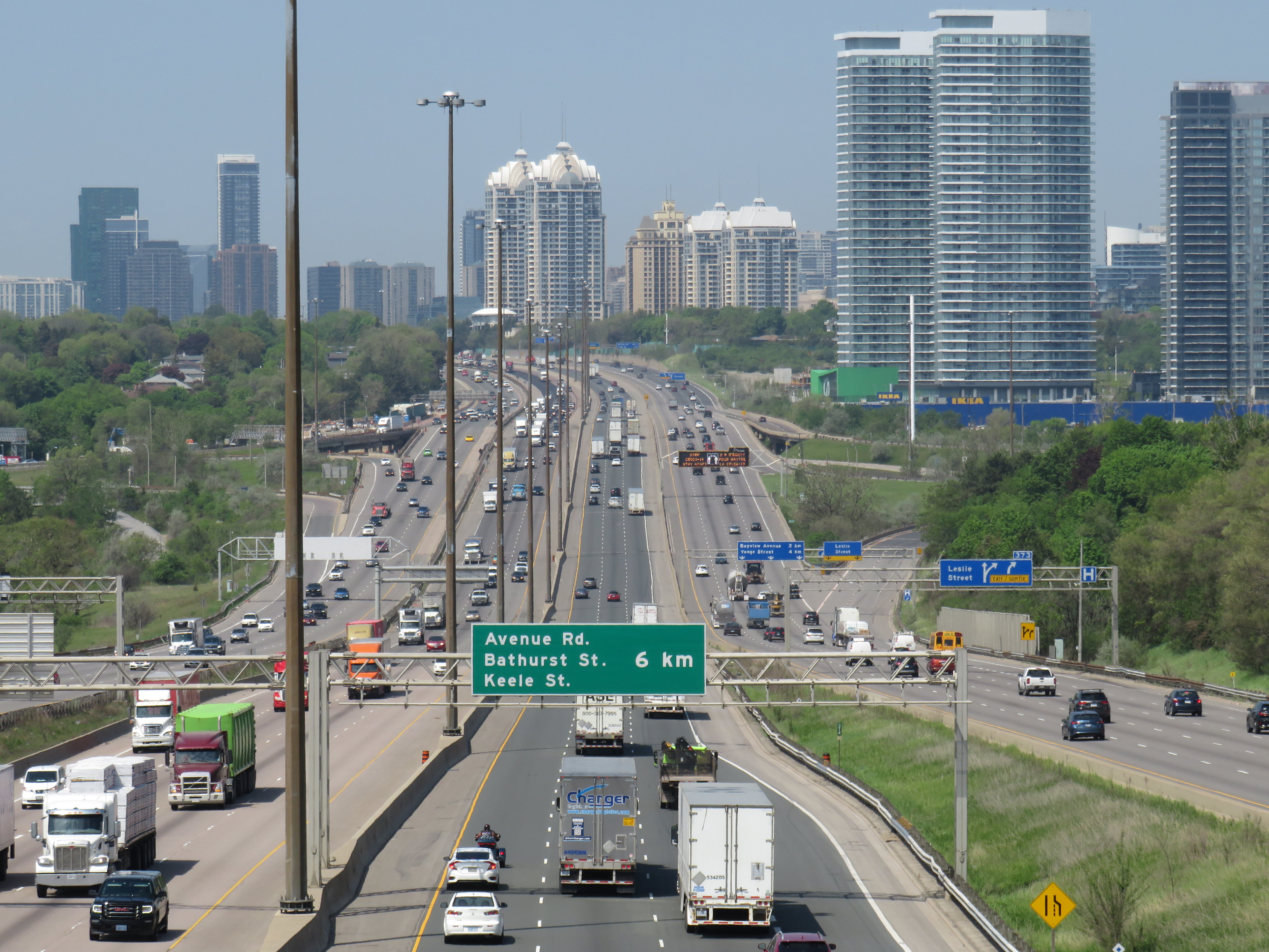
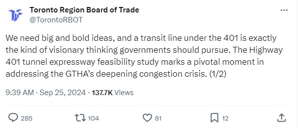
There is no way a Highway 401 tunnel will be built. Not only would it be the longest road tunnel in the world, but the long on-ramps and off-ramps required to access a deep-bore urban highway tunnel will make it completely infeasible. The proposal also completely ignores the problem of induced demand, and it won’t solve the problem of where the traffic goes when it gets off that additional highway. For these reasons, it was especially disappointing to see the Toronto and Region Board of Trade (TRBoT) endorse the idea.
There are things that can help alleviate traffic. One is ensuring that transit projects are completed, funded, and maintained. That doesn’t just mean building and completing projects like the Crosstown LRT and the Ontario Line, it’s also making sure the system remains in excellent condition to avoid problems like the persistent slow orders in the Toronto Subway. It also means making the best use of existing infrastructure, like Highway 407, for goods movement. Highway 407 passes by every major freight yard in Greater Toronto, but trucks clog Highway 401, Highway 7, and Steeles Avenue instead because of the high tolls. And it means active transportation improvements, like bike lanes and multi-use paths.
What we don’t need are more dead cats to distract us from the real problems.
No matter how you get around Toronto, it’s feels like it’s more difficult than ever
Getting around Downtown Toronto can be an exercise in frustration, whether you drive, bike, take transit, or drive. Though necessary transit and road construction projects are the cause of much of the congestion, driver behaviour, poor management, and a lack of coordination between various municipal and provincial agencies have only added to the traffic quagmire.
North-south streets such as Spadina, York, Bay, and Jarvis are jammed by drivers headed south towards the Gardiner Expressway, with lane closures near Exhibition Place only making things worse. Motorists blocking intersections make it difficult for pedestrians, cyclists, streetcars, and through traffic to get across the city centre. Ontario Line construction has closed a portion of Queen Street, while work to rebuild streetcar tracks on York and Adelaide Streets to allow 501 cars to bypass the closure is still proceeding.
GO Transit is also expanding its rail corridors to allow for more off-peak and express trains, with the long-term goal of having an electrified, frequent, regional rail network that complements and supplements the web of subways, light rail and buses throughout the region. The TTC is also addressing a backlog of state-of-good repair works throughout the subway system, resulting in slow orders, early closures, and weekend shutdowns.
Meanwhile, people still need to get to places like work, school, conferences and trade shows, concerts, sporting events, social gatherings, festivals, museums, and all the other things that make a city a city. Eventually, with improved GO corridors, the Ontario Line, and the opening of the Crosstown LRT, there will be some redundancy in the transit system that will make planned service closures easier to navigate. But for now, we are stuck with an underbuilt transportation system in a rapidly growing city.
This makes the coordination of transit closures and projects especially essential so things don’t completely fall apart. Saturday, September 21 was just one example of the failure to do so.
On Saturday September 21 and Sunday September 22, GO Transit reduced service on the Lakeshore West Line to hourly service on the entire corridor because of work at Long Branch GO Station, where the station is being completely rebuilt for accessibility improvements and future expansion. It also shut down the entire Barrie Line for various construction works along the corridor, with rail replacement buses to Union Station, stuck in traffic on the Don Valley Parkway and Lake Shore Boulevard with all other motorists getting around the Gardiner closure.
Normally, there are hourly trains as far west as West Harbour Station in Downtown Hamilton, with half-hourly service to Aldershot Station in Burlington. Between Union and Oakville, rail service is as frequent as every 15 minutes during midday and early evenings on Saturday and Sunday. Hourly train service reduced capacity on the inner Lakeshore West line by 75%.
Compounding the problem was the total closure of the Gardiner Expressway between Highway 427 and the Don River between Friday evening and Sunday morning for routine maintenance (the Gardiner and the Don Valley Parkway are regularly closed twice a year for repairs). Many people who might have otherwise driven into the city would have taken GO Transit instead, normally a very good idea. Though none of Toronto’s professional sports teams were playing at home on Saturday, there was still a Shane Gillis stand-up comedy performance at Scotiabank Arena, and a Rainbow Kitten Surprise concert at Ontario Place.
Also, to add insult, the Lakeshore East trains between Toronto and Oshawa were not through-running with the Lakeshore West trains and were operating on a modified schedule. I was travelling east of Toronto on Saturday, making a few stops in Durham Region. As I arrived back from Whitby on Saturday afternoon on a train that normally connects onward westbound train at Union Station, we were treated to the sight of the hourly Lakeshore West train just pulling out. It couldn’t have even waited 2-3 minutes to allow passengers to make the cross-platform connection. That resulted in other passengers complaining to GO staff in the concourse, who were not that helpful.
I’m on the GO Train now. The CSR on the LW train is telling people at Long Branch to not board because the train is too full, so they now have to wait an hour. Lots of people heading to Budweiser Stage and Scotiabank concerts. Very poor planning/coordination between city and MLX. https://t.co/LXNATzYwoV
Tweet from Alan Deschamps, reporting on a full GO train arriving at Long Branch at 6:21 PM on Saturday Sept 21, with the customer service ambassador (CSR) telling waiting passengers to not board and to wait for the next train in an hour
In the early evening on Saturday, a jam-packed eastbound GO train on the Lakeshore East train was not accepting any passengers at Long Branch or Mimico station because of overcrowding. Waiting passengers were told to wait an hour for the next train.
One would think that Metrolinx (GO Transit’s parent agency) and the City of Toronto would coordinate their construction schedules to avoid such problems. However, not even the City of Toronto can figure this out. Back in June of this year, the TTC replaced the 509 Harbourfront and 511 Bathurst streetcars with buses for a week for minor overhead work on Fleet Street. The timing coincided with the massive Collision tech conference at Exhibition Place, which resulted in overcrowded shuttle buses and unreliable service. Had the TTC checked with anyone at the city’s economic development office or with Exhibition Place (another city agency), this work could have easily been rescheduled.
Overloaded 509 Harbourfront bus shuttle on Queen’s Quay in June 2024
Though coordination of transit closures and construction projects with major events and parallel roadworks will not solve Toronto’s road and transit congestion problems, it will at least reduce some of the frustration of getting around. The poor customer service at GO Transit will certainly make riders question if they will be able to rely on the service in the future.
Of course, there is one measure that won’t help but still will be implemented by the provincial government later this fall: a prohibition on new bicycle lanes if they take road space from motorists. Despite blocked bike lanes, aggressive drivers, and an incomplete cycling network, it is still the most reliable and fastest mode for many shorter city trips. Along with major transit improvements and construction coordination, cycling is one of the solutions to getting around Toronto.