Marshall’s Musings

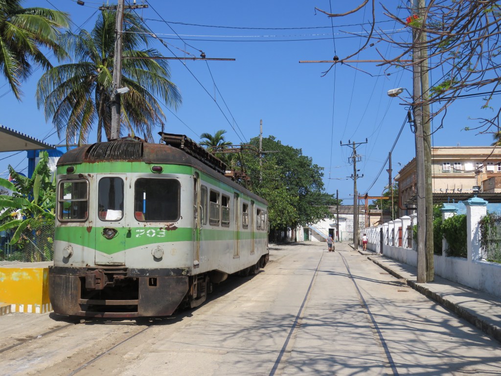
  • Cuba’s Hershey Train: the last interurban railway

    IMG_1305-001

    Last week, my partner-in-crime and I escaped to Cuba for a short vacation. Eschewing the all-inclusive resorts at Varadero, we decided to spend our time in Havana instead.

    Havana is a fascinating place that’s worth exploring beyond the popular spots such as the picturesque Old City, Revolution Square, and the Cristóbal Colón Cemetery; like any great city, it is best explored by foot.

    One of our highlights was getting an impromptu tour of the José Martí National Library of Cuba in Havana. The library, named for the Cuban national hero, is adjacent to Plaza de la Revolución. The Plaza also holds the seat of the Communist Government and is famous for the towering monument of Martí and the metal mural of Che Guevara.

    We met a wonderful guide, who with great pride described the library’s programs, but also the effects of the 55-year American embargo on obtaining educational materials, up-to-date computers and access to the Internet and other digital resources. We were fortunate for experiences like that, where we met interesting people and learned a bit more about the country. These were experiences that tourists staying at beachside resorts, perhaps visiting Havana on a bus tour or to see a cabaret show, sadly miss.

    But, being on vacation, we made sure to spend some time to relax and enjoy the hot — yet pleasantly non-humid — weather. So we decided to go to the beach for our last full day in Cuba. But instead of taking the tourist buses, we decided to hop on the Hershey Train, probably the last true interurban railway in the Americas.

    Interurban railways once existed all over Canada and the United States. Electrically-powered trains linked towns and cities together, providing passenger and local freight services and filling a niche between urban streetcars and long-distance steam railways. Improved roads, and increased car and truck ownership resulted in the closure of just about every interurban railway in North America, the last to close in Canada was the Niagara, St. Catharines and Toronto Railway in 1959. A few remnants of North America’s interurban lines survive as modernized commuter services, such as the South Shore Line between Chicago and South Bend, Indiana. But Cuba’s Hershey Train still looks, and operates, like the electric railways that once crisscrossed much of southwestern Ontario and the eastern United States.

    (more…)

  • Missed opportunities on the Mississauga Transitway

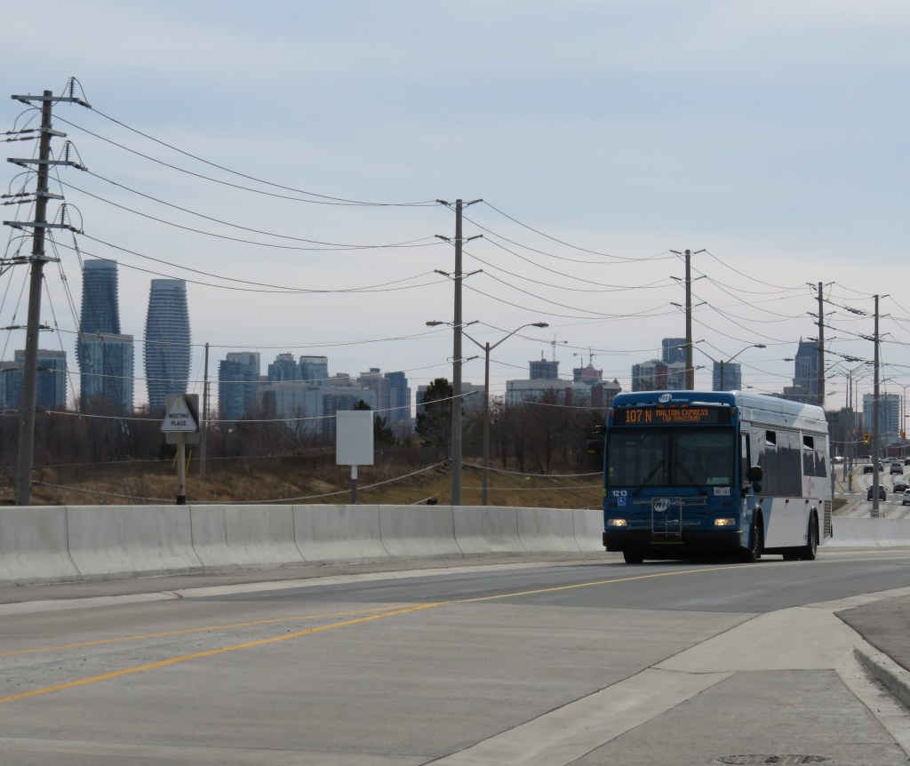
    IMG_0343-001Route 107 Malton Express bus on the Mississauga Transitway at Tomken Station

    After riding the UP Express back in March, the inspiration for a post on a proposed transit hub at Toronto Pearson International Airport, I went for a ride on the Mississauga Transitway.

    I first rode the Mississauga Transitway on a snowy Monday, November 17, 2014, the day it opened. At the time, only four stations were opened — Central Parkway, Cawthra, Tomken, and Dixie. On my first visit, I was unimpressed. But I decided to give it another try after the two new stations opened, on a Saturday, when I had plenty of time to check out the service, the new stations, and the environs.

    I have many thoughts and criticisms about this new piece of transit infrastructure, which will cost the City of Mississauga and Metrolinx a combined $528 million.

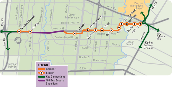
    mississauga_transitway_map_en-670x340Map of Mississauga Transitway, taken from the GO Transit website

    What is the Mississauga Transitway?

    The Mississauga Transitway is a bus rapid transit (BRT) project. BRT is a term used in the transit industry to describe everything from limited-stop conventional buses, perhaps with some perks like all-door boarding and queue-jump lanes sometimes called BRT-lite (Brampton Zum is a good example), to fully grade-separated, high speed bus corridors that operate like metro lines (the Ottawa Transitway and Bogota’s TransMillenio system are good examples). Other busways in Canada include the Ottawa Transitway, to be partially replaced by light rail transit, the Gatineau Rapibus corridor, York Region’s Viva Rapidways, and Winnipeg’s RT corridor.

    The Mississauga Transitway is a true BRT system, but it has several major weaknesses.

    (more…)

  • GO Transit and the high cost of “free” parking, Part II: Brampton Boogaloo

    IMG_0610-001

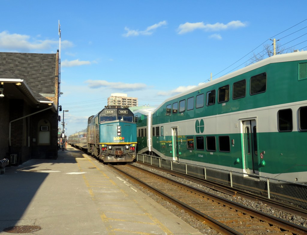
    GO and VIA Trains meet at Brampton Station

    September 20, 2016 update: Metrolinx has begun the process of demolishing its newly-acquired Downtown Brampton properties. It has applied for a demolition permit for 28A and 28B Nelson Street West, two semi-detached dwellings that were built in 2001. In the  City of Brampton, demolition permits for residential properties must be approved by the Planning & Infrastructure Services Committee. The permit will likely be approved at the September 26, 2016 meeting of that committee.


    On April 5, 2016, Peter Criscione at the Brampton Guardian reported on a matter that arose during the regular meeting of the City of Brampton Planning & Infrastructure Services Committee on April 4. Metrolinx, the regional transit authority that operates GO Transit and UP Express, confirmed the purchase of 1.78 acres in Downtown Brampton, land that will be used for surface parking.

    Brampton Station, served by GO Transit and VIA trains, is located in Downtown Brampton, and is adjacent to Brampton Transit’s downtown transit terminal. With local shopping, restaurants, residential areas and employment, it is one of the most walkable stations in GO Transit’s system; it has a Walk Score of 90. (Bramalea GO Station, in comparison, has a Walk Score of 22.) The options of getting to Brampton Station without a car are quite good, at least as far as most GO stations go.

    But Brampton Station’s two lots are full, and there are planned service improvements to Brampton, including eventual hourly evening and weekend rail service. Not everyone can be expected to take transit, walk, or get a ride to the station. But I find this land assembly troubling.

    According to Criscione, and noted in the minutes of the April 4 meeting [page 25-26], the properties purchased by Metrolinx include:

    • 20 Nelson Street West
    • 37 George Street North
    • 41 George Street North
    • 26 Nelson Street West
    • 3 Railroad Street (includes 3 separate parcels)
    • 28A Nelson Street West
    • 28B Nelson Street West
    • 30 Nelson Street West
    • 42 Elizabeth Street North

    The planning committee asked staff to contact Metrolinx and report on the status of its recent and pending purchases of downtown lands. It also invited Metrolinx to work with city staff and officials, as well as present their plans at a future meeting.

    The purchase of downtown lands for a parking lot is troubling, in my opinion. Downtown Brampton is a designated “anchor hub” — a major mobility hub where two or more rapid transit lines meet where transit-oriented development and intensification is encouraged. At no point do I see new surface parking lots are part of this vision, especially if buildings must be vacated and demolished to do so. And Downtown Brampton, not yet experiencing a building boom, has plenty of parking lots and garages that could be employed instead.

    The embedded Google Map below shows where these properties are located, immediately south of Brampton Station, and west of the Brampton Transit downtown terminal.


    On Friday, April 8, I visited Downtown Brampton to have a look at the properties in question.

    (more…)

  • Mapping Major League Baseball’s stadiums by walkablity, transit access

    22078160783_012aad4fb6_k

    What major league ballpark is the easiest to get to by public transit? Which stadium has the highest walk score? And where does the phrase “take me out to the ball game” absolutely require getting in a car and fighting traffic to do so?

    Over at Torontoist, I explore these questions in more detail. I created a map of all thirty major league stadiums (and the 2017 home of the Atlanta Braves). About half the stadiums are located in downtown areas or urban neighbourhoods, close to transit stations, bars, restaurants, and shopping; the other half are generally surrounded by parking lots.

    SkyDome isn’t a great ballpark, especially when the dome is closed, but in these rankings, it does really well.

  • The many challenges of creating a transit hub at Pearson Airport

    7afe7e75-d368-4472-b208-ab02c57457aa-001
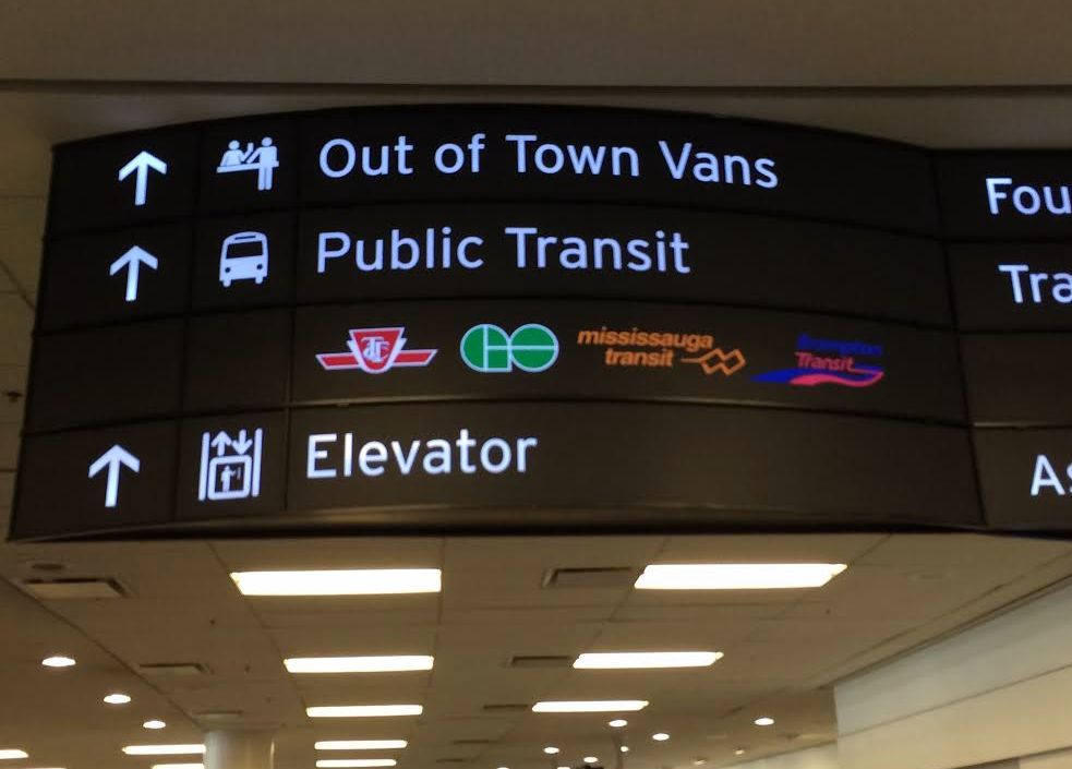
    Sign in Terminal 1 at Pearson Airport. Whether we realize it or not, Pearson Airport is already a transit hub. 

    Updated April 7, 2016

    Lester B. Pearson International Airport is Canada’s busiest airport, handling 41 million passengers a year. It is not the busiest transportation hub in the Greater Toronto Area, though; Union Station is considerably busier (GO Transit alone handles 64.4 million passengers a year at Canada’s busiest station).

    Pearson Airport is located almost entirely within the City of Mississauga, but the terminals are less than a kilometre away fromthe City of Toronto’s western boundary; due to the location of the airport terminals, most passengers reaching the airport by road, or transit pass through the City of Toronto to get to it.

    The Greater Toronto Airports Authority (GTAA), the not-for-profit agency that operates Canada’s busiest airport, has expressed interest in creating a transit hub and guiding transit-oriented development around it. It’s an interesting idea, and some of the facts are compelling.

    There are approximately 300,000 jobs located at and near Pearson Airport. The airport itself hosts 40,000 employees that work for the airport authority and its contractors and tenants, including retailers, airlines, and allied services. The remaining 250,000 jobs are located in office parks and industrial areas that surround the airport, in the cities of Toronto, Mississauga, and Brampton, a very large area that extends north into Bramalea, west of Hurontario Street and south to Highway 403.

    You can read the GTAA’s report, written by the prestigious planning firm Urban Strategies Inc., and named Pearson Connects: A Multi-Modal Platform for Prosperity online as a PDF. The report claims that Pearson Airport and environs has more jobs, and more economic clout than any Canadian downtown, with the exception of Downtown Toronto. To a degree, this is true. But the size of the Airport Employment Zone, as the GTAA defines it, is much larger in size than any downtown, even Toronto’s; the jobs are mostly dispersed in warehouses, factories, and suburban office buildings difficult to reach by transit.

    In fact, Pearson Airport and its surrounding area — all 25,600 hectares  (256 square kilometres) — has fewer than 25 employees per hectare, while Downtown Toronto, one-tenth the size, has nearly 200 employees per hectare (and a growing residential population as well). Igor Dragovic calculated these figures from a recent Neptis report. The low employment densities found in business parks and warehouse districts are only partly to blame; the airport itself, with five active runways and a large land buffer, contributes to this.


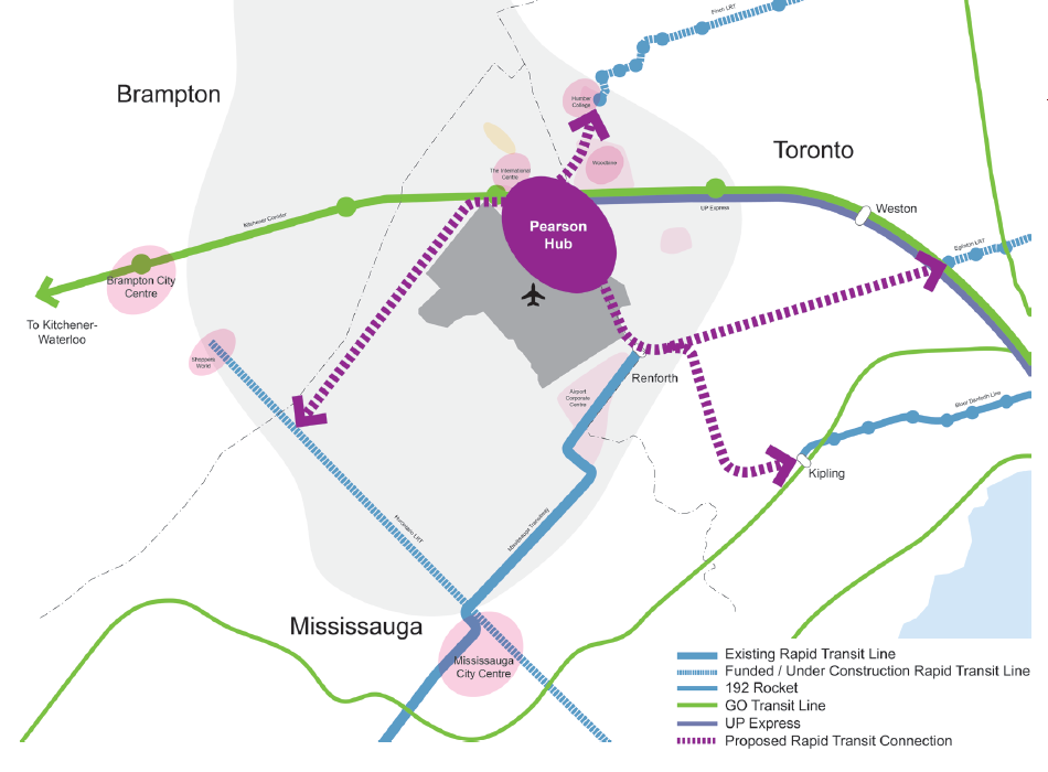
    The GTAA wants to build an “airport-related multi-modal hub” that would tie together existing and planned rapid transit services, including the Kitchener RER Service, LRTs on Eglinton and Finch Avenues, the Mississauga Transitway BRT and a proposed Derry Road transit corridor.  It cites airports in Amsterdam, Frankfurt, London, and Hong Kong as examples to emulate.

    GTAA ProposedThe GTAA’s proposal for a transit hub, taken from Page 7 of the report

    The report also neglects to recognize that Pearson Airport is already a major transit hub; the problems lie in integrating the existing and proposed transit services together. And for an area the size of the GTAA’s Airport Employment Zone, that’s a very tall order.

    (more…)

  • The future… never!

    IMG_6258-001

    High speed rail: it’s an idea that has been talked about in Canada since the 1960s. But sadly, in 2016, we’re still just talking about it.

    I’m a big fan of passenger rail. I’ve rode on most of VIA’s network, from coast to coast, as well as several long distance Amtrak lines in the United States, as well as trains in Britain, Continential Europe, and China. I enjoyed riding high speed rail (HSR) trains between London, Paris, and Amsterdam, but I also appreciate a leisurely cross-country ride. In Canada, the train isn’t very fast, nor is it very reliable, but it’s a comfortable, peaceful, and social way to travel. It’s still my favourite way to travel to Ottawa or Montreal.

    Passenger rail — excepting commuter services such as GO Transit — declined in this country in the last 40 years, in terms of ridership, speed, and reliability. There are thousands of kilometres of track in Canada that hosted passenger trains only a few decades ago that are now torn up, the land sold off or turned into rail trails. In 1989, there were five trains a day in each direction through Kitchener and Stratford. Today, there are just two.

    In 1976, a year before VIA Rail Canada was formally established, the fastest trains between Toronto and Montreal, (CN Trains 66 and 67, the famous Turbo,) were scheduled to take 4 hours and 10 minutes, stopping only at Guildwood and Dorval.

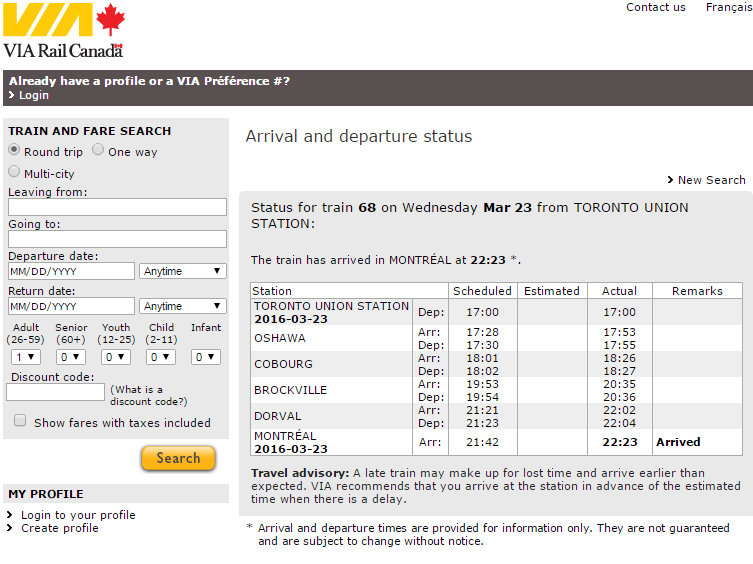
    Today, the fastest train between Canada’s two largest cities, Train 68 from Toronto, takes 4 hours and 42 minutes, if it’s running on time. (It didn’t on Wednesday, March 23, arriving 41 minutes late into Montreal.) And there are only six direct trains in each direction between the two cities.

    VIA Train 68 Status - March 23 2016
    Delays, despite longer scheduled travel times, are common on the Corridor

    While commuter rail services are expanding in Toronto and Montreal, passenger service has not. Since being formed in 1977, VIA Rail suffered through several major cutbacks in 1981 and 1990, and minor cuts in 2004 and 2012; but VIA held on despite the neglect – – or complete disdain — of both Liberal and Conservative governments. Ridership fell, not because people didn’t like riding trains, but because governments didn’t want to fund rail services, nor did freight railways like hosting them. Roads were seen as investment; passenger rail an expense.

    (more…)

  • On transit ridership in the GTHA

    Earlier this week, the Toronto Transit Commission (TTC) released its agenda for the next board meeting, to be held on March 23. Among the items to be discussed are updates on the delayed Line 1 subway extension to York University and Vaughan, plans for the Line 2 subway extension to Scarborough Centre, the new MiWay/GO Transit terminal at Kipling Station, the planned new 514 Cherry streetcar line and other Waterfront bus improvements, and a ridership update.

    As always, Steve Munro is on top of it all, and I encourage you to read his post.

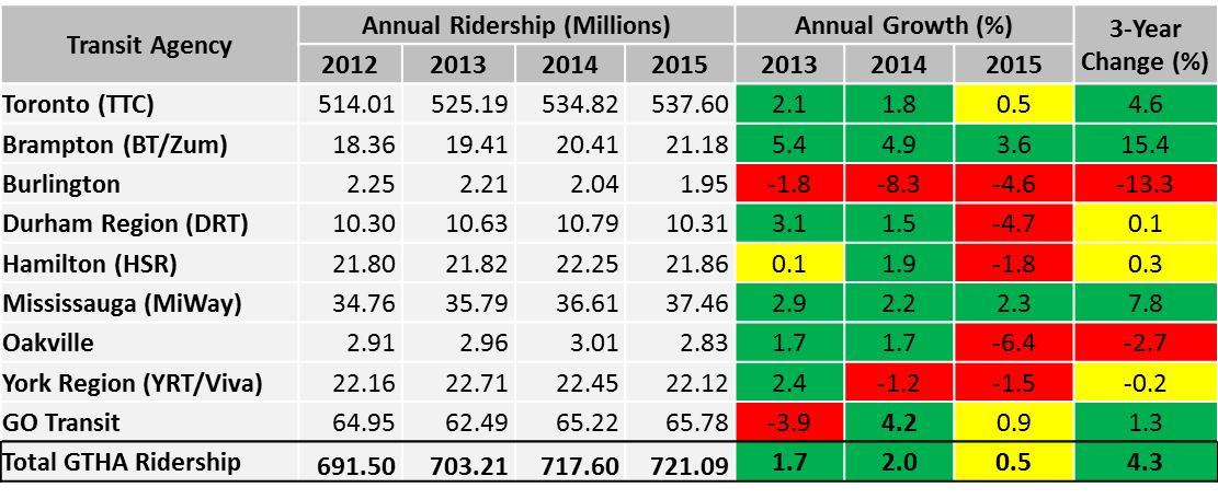
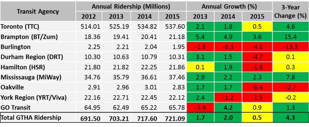
    I wanted to make a few observations about ridership, especially in Toronto’s suburbs. Growth in the TTC’s ridership has slowed down in the last three years, from a 2.1% annual increase in 2013, to a much more modest 0.5% increase in 2015.

    Ridership figures are not detailed enough to know at what times of the day ridership is changing, nor on what routes. But ridership growth has fallen (or even declined) for other major Canadian transit systems, including Vancouver, Montreal, and Ottawa. There are many causes for changes to ridership — population and employment growth or decline, fare increases, service improvements or cuts, even the cost of gas, which has been declining in the last two years. Much of the employment growth within the City of Toronto has been in the downtown core, but so has the population growth due to new residential highrises. (I’m one of thousands who live and work in or near the downtown core — my TTC use is now mostly during the evenings and weekends as I mostly walk to work).

    Hopefully, the Commission and the city don’t use this short-term trend as  an excuse to hold back on needed service improvements or projects such as the Relief Line — for one thing, many buses, streetcars and subway trains are already overcapacity, and it is impossible to know whether slower ridership increases represent a long-term trend, or a short-term blip.

    There was one table in the TTC ridership update that caught my attention. The table, on page 5, shows the ridership for every Greater Toronto and Hamilton Area transit system (though excluding Milton Transit). I reproduced that table below.
    Ridership

    GTHA transit agency annual growth rates, 2013 to 2015. Adapted from TTC 2016 Ridership Update, page 5.

    While the TTC’s ridership growth has slowed, ridership in many suburban municipalities have either flatlined or declined. Only Mississauga and Brampton show consistent, positive growth over the last three years. MiWay, previously known as Mississauga Transit, hasn’t expanded transit operations that much in the last few years, but that city continues to enjoy modest employment growth and improved connections to the airport, Brampton Transit and the TTC. It is currently building a new bus rapid transit (BRT) line, the Mississauga Transitway (more on that in a later post), and city council is backing the Hurontario LRT line, which would largely replace bus service on its busiest corridor.

    Brampton’s growth has been, by far, the most impressive. That suburban municipality is growing thanks mostly due to new sprawling subdivisions, but since in the last decade, Brampton Transit has been introducing annual system improvements, including the Zum “BRT-lite” network of limited-stop bus routes. Brampton’s ridership is now almost that of the Hamilton Street Railway (HSR). Unlike Hamilton, Brampton doesn’t have two major post-secondary educational institutions, nor a dense urban core, though it serves Humber College, York University, and two secondary Sheridan College campuses in Brampton and Misssissauga.

    In Hamilton, ridership dropped by 1.8% in 2015. Most ridership in Hamilton is concentrated in the lower city, as well as a few trip generators in the suburbs, including Mohawk Collage on the Mountain, and Lime Ridge Mall. Many parts of the lower city have been hit hard by job losses in that city’s major industries, though new subdivisions (and, to a lesser extent, downtown gentrificaton) have contributed to modest population growth. Hamilton is going ahead with a provincially-funded east-west light rail line that will connect McMaster University, Downtown Hamilton, and the east end.

    Elsewhere, transit ridership growth has been quite disappointing. Burlington Transit saw a drastic 13.3% decline over the last three years, Durham Region, which I recently visited, saw a major decrease in 2015. However, there is lots of promise in its five-year service strategies, which will improve and simplify the agency’s route structure and provide enhanced service.
    2015 Ridership
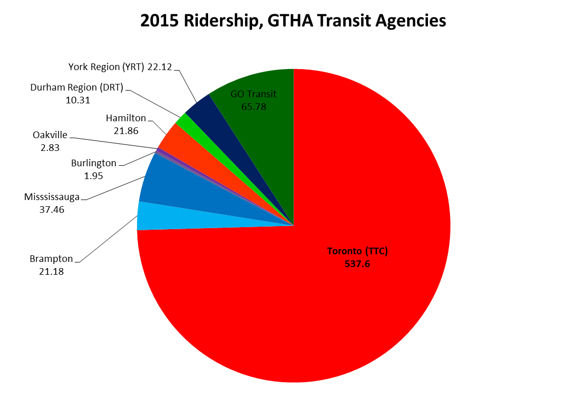
    2015 ridership for GTHA transit agencies (Milton excluded). The TTC, with narly 75% of the region’s ridership total, dominates. GO Transit holds another 9%. 

    York Region Transit, serving a population of 1.2 million, has only 1 million annual riders more than Brampton, whose population is nearly half of York’s. And despite adding new subdivisions (and a few new residential towers), ridership declined in the last two years. As illustrated in the table below, YRT’s ridership per capita is less than half of Hamilton’s or Mississauga’s.
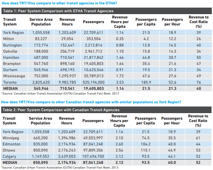
    YRT Ridership StatsComparing York Region Transit to other Canadian transit systems, 2013. From the VRT/Viva 5 year service plan, page 7. 

    It’s interesting that despite poor transit ridership (amid York Region Council-mandated service cuts and steep fare hikes) York Region, with senior government assistance, is spending $1.4 billion on dedicated median busways on Highway 7, Yonge Street and Davis Drive. York Region will get the Spadina subway extension in 2017, and it pines for an extension of the over-burdened Yonge Subway to Richmond Hill Centre.

    In York Region, there’s a troubling disconnect between spending money on capital projects and funding the services that will use the shiny new infrastructure, or feed ridership to it. Brampton has proven that growing service, not necessarily fancy infrastructure, will grow ridership. That said, it remains disappointing that the suburban municipality with the best record for ridership growth in the Toronto region rejected a funded light rail transit line to its downtown core.
  • Where the sidewalk ends in Toronto (Updated)


    IMG_3357
    McNicoll Avenue at Boxdene Avenue. There’s no sidewalk on the south side of this busy Scarborough road.

    Update: I posted a revised and updated version of the map and article on Spacing Toronto. There, I mention a new absurdity in the war on sidewalks: on Glen Scarlett Road, near the old Stockyards in Toronto’s Junction neighbourhood, the city is proposing  a new sidewalk for 2016 as part of a road reconstruction project.

    The local councillor, Frances Nunziata, is siding with local industry in opposing a sidewalk. Local industries — including slaughterhouses and warehouses — oppose a sidewalk as it would cross their loading docks; Nunziata’s office claims that since the street “is unsafe for pedestrians to be walking on due to heavy traffic, [the City] should not be encouraging pedestrians to use this road by installing a sidewalk.”

    This logic is completely counter-intuitive. It ignores the needs of workers walking to work, and local residents walking to the streetcar loop at St. Clair Avenue and Gunns Road, or to nearby shopping and residential areas.


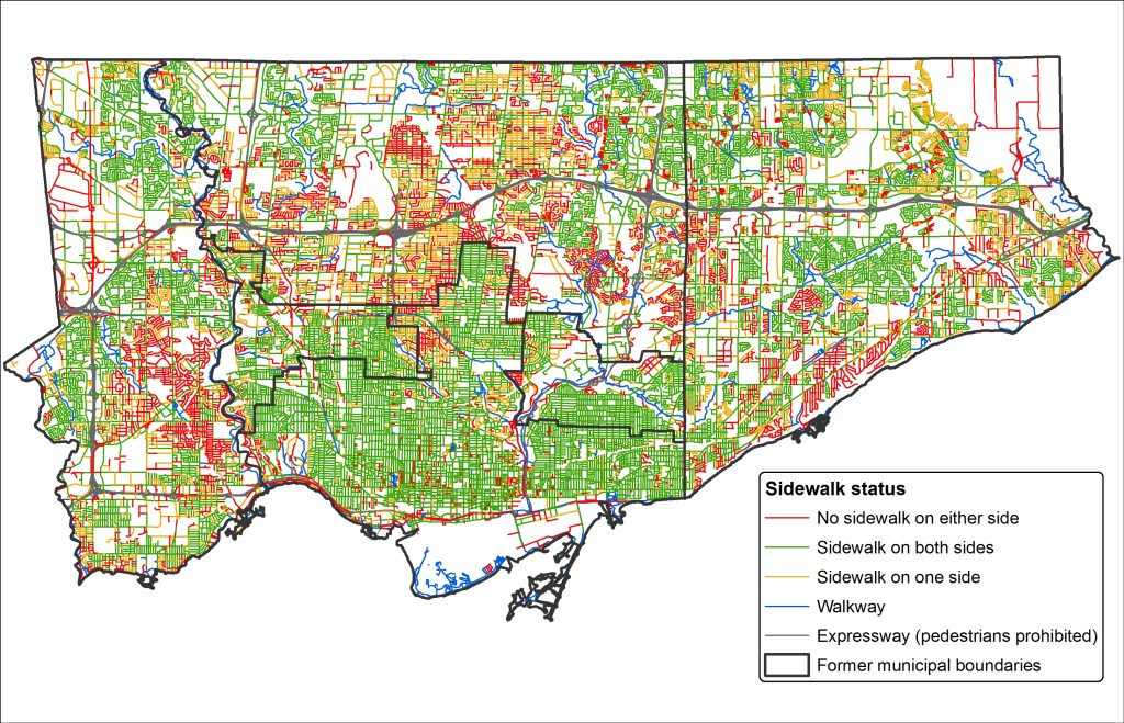
    There was a very interesting interview on CBC Radio’s Metro Morning on Tuesday, February 16). Host Matt Galloway spoke with Fiona Chapman, the City of Toronto’s manager of pedestrian projects, on missing sidewalks. Nearly one-quarter of all local streets in Toronto don’t have a sidewalk; many more only have a sidewalk on one side of the street. Chapman was discussing a presentation to the City’s Disability, Access, Inclusion and Advisory Committee on staff recommendations that would seek to fix this problem.

    CityData - SidewalksStatic map showing the City of Toronto’s sidewalk inventory as of 2011.

    Most local streets that don’t have sidewalks are found outside the old Cities of Toronto, East York and York, particularly in parts of Etobicoke, North York and Scarborough built in the 1950s and 1960s. Some of these residential and industrial streets were built with ditches instead of storm drains; others were laid out without sidewalks in mind. In the master-planned Don Mills development, there are many walkways connecting parks, major roads, and schools; it was likely intended that these would be used for getting around on foot rather than sidewalks. In other post-war subdivisions, particularly affluent areas like those in central Etobicoke, it was probably assumed that everyone would get around by car.

    The City of Toronto is hoping to change this. As roads come up for reconstruction, the new policy, recommended by staff, is to install a sidewalk where there isn’t one already, even despite local opposition. The current policy, in place since 2002, is that a new sidewalk could only be installed on an existing local street after the local councillor completed a consult of the neighbourhood and there was a consensus supporting the installation.

    In Toronto, the installation of new sidewalks has been surprisingly controversial. But the city’s presentation lists some of the reasons why sidewalks are often opposed. Sidewalks have to be cleared by the adjoining landowner. Residents can’t park their cars in the driveway if they block the sidewalk. They might result in the removal of landscaping or trees. And there is a minority who just want to keep outsiders out of their neighbourhoods. You could call this NIMBY-ism, even though sidewalks are technically is in the front yards, not the backyards, of local opponents.

    Sidewalks provide safe, accessible routes for pedestrians, especially important for people using strollers or mobility devices. They promote the city’s initiatives encouraging children to walk to school, for all persons to engage in physical activity, and for seniors to age at home. City policy, including the Toronto Pedestrian Charter, supports sidewalks.

    On Chine Drive, in an affluent part of Scarborough near the Bluffs, local residents opposed the construction of a sidewalk, even though it would provide a safe path to a nearby school. Since 2004, some residents opposed the sidewalk, claiming that they were afraid it would “take away from the rustic look of the neighbourhood.” Supporters, including parents with young children, wanted a safe route to the local school. It took ten years, but in 2014, the sidewalk was installed.

    Last year, on nearby Midland Avenue South, there was a similar fight to keep sidewalks off of that street. This is despite the fact this section of Midland Avenue is designated as a collector road, and is part of the Waterfront Trail’s route in the Scarborough Bluffs area. The city owns the land, known as a boulevard, where the sidewalks would go, but without the consent of local homeowners, the city was left in a bind. This new city policy will hopefully solve this problem.

    Below, I created an interactive map of the City of Toronto’s sidewalk inventory, created with data from the City of Toronto’s Open Data Initiative. It shows each public street in the city of Toronto (excluding private roads and laneways), as of 2011. I made a few edits, such as including the new Chine Drive sidewalk, and correcting a few errors that I was aware of.

    Almost every arterial and collector road in Toronto has a sidewalk on at least one side of the street. Exceptions include Highway 27 and Black Creek Drive, where, like expressways, pedestrians and cyclists are prohibited, the Bayview Drive Extension though the Don Valley, and in the far northeastern part of Scarborough, in Rouge Park. But it’s the local streets, marked in orange and red that are most apparent.

    https://seanmarshall1.cartodb.com/viz/3f206014-d4f2-11e5-b47b-0e787de82d45/public_map


    Providing safe, accessible, and consistent pedestrian infrastructure is simply the right thing to do. The city owns the land on which sidewalks can be put down, if they aren’t already. There are legitimate concerns that need to be taken into account when new sidewalks are proposed — trees and landscaping especially — but at the end of the day, the needs of vulnerable road users need to be addressed first and foremost.

  • Tunnel Vision: A History of Toronto’s Subway

    IMG_0209-001

    If you haven’t yet had a chance to go, you should be sure to visit the Market Gallery at St. Lawrence Market. The current exhibition, called Tunnel Vision: The Story of Toronto’s Subway, is a fascinating collection of maps, photographs, memorabilia, and drawings illustrating over a century of subway plans and operations in Toronto. Dominating the gallery, which was the City of Toronto Council Chambers in the 19th century, is the front of an H-4 subway car; visitors are encouraged to take selfies with it.

    While Canada’s first subway opened in 1954, there were serious subway proposals that date back to 1910. Interestingly, many of these early subway maps feature a line that looks very similar to the (Downtown) Relief Line.

    I wrote more about this exhibition, which continues until June 11, 2016, in Torontoist. 

  • Welcome to Toronto, we guess

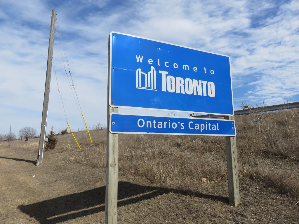
    Welcome sign when entering the City of Toronto

    Last weekend, I was out exploring the Toronto-Mississauga border. I have a few thoughts about suburban transit projects like the Mississauga Transitway and as I have time, I’ll post those here.

    But where Eglinton Avenue crosses Etobicoke Creek, motorists (and the few brave cyclists and pedestrians), are greeted with a sign that said, simply, “Welcome to TORONTO” and underneath, “Ontario’s Capital.”

    Yes, Toronto is the capital of Ontario; that’s what they teach childen in Grade 2, along with the other provincial and territorial capitals of Canada. But surely, a city of three million people that’s known for its talent, creativity, and diversity can come up with something better than this uninspired sign, which is found at many, if not most, entrance points to the city. The welcome sign would even better off without the “Ontario’s Capital” tab.

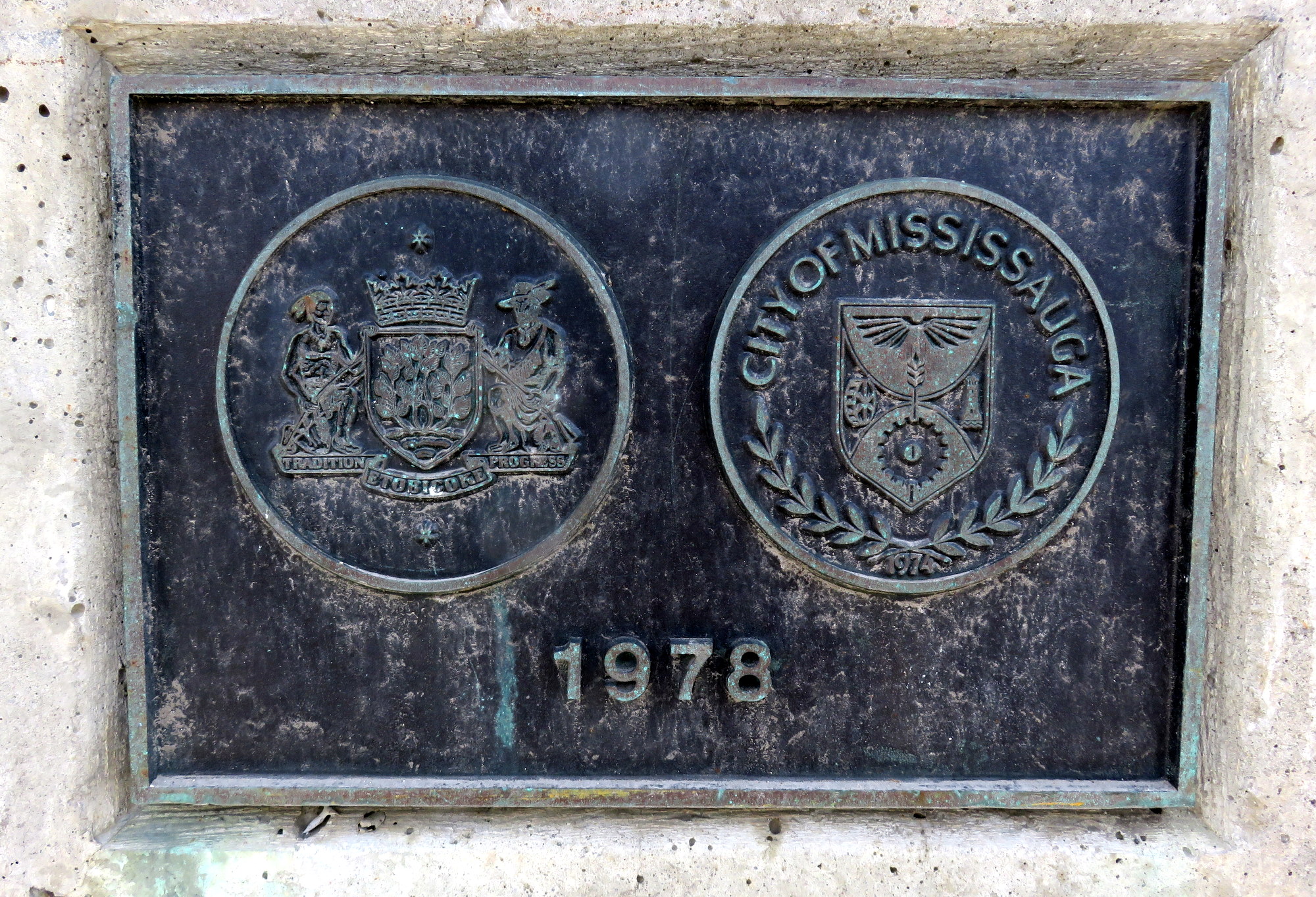
    But while I was walking on the Etobicoke Creek bridge — a hostile environment as any for a humble pedestrian — I noticed this plaque, marking the border between the City of Mississauga and what was then the City of Etobicoke. The bridge was built in 1978, but is being widened to support a new bus rapid transit project. This section of Eglinton is built for cars, but it is only as a pedestrian that you can spot this sort of detail.

    IMG_0312-001

    In 1978, Etobicoke’s motto was simply “Tradition and Progress” while Mississauga’s crest didn’t sport a motto. Today, signs welcoming you to Mississauga say “Leading today for tomorrow, a rather boastful, yet meaningless slogan.