Marshall’s Musings

  • Mapping Toronto’s Rental Complaints

    MLS - Draft 2

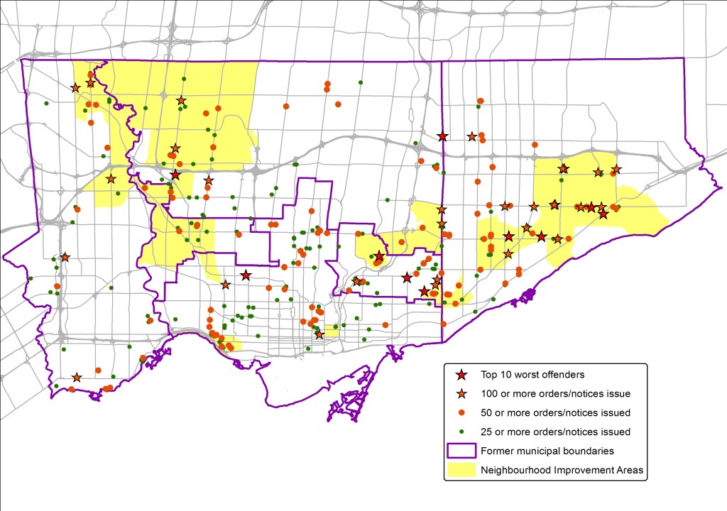
    Over at Torontoist, I took a look the City of Toronto’s data on complaints made to Municipal Licensing and Standards (ML&S) on multi-residential apartment buildings. All properties with at least 25 notices or orders that are either open, or issued and closed within the last two years are mapped; the ten properties with the highest number of offenses are highlighted and listed.

    Many ML&S investigations are the results of neighbours’ complaints of improper waste disposal, graffiti, long grass, unkempt grounds, or fence disputes; these complaints are distributed all over the city. These are usually quickly solved, resulting in only one or a handful of orders issued. However, troubled buildings might have dozens, even hundreds of violations, ranging from poor groundskeeping, to poor interior lighting, to more cringe-worthy deficiencies such as failures to guard against pest infestations, leaking pipes, damaged and stained ceilings and walls, and unsanitary waste collection and storage. Failure to comply with enforcement officers’ orders can result in prosecution.

    Most of the properties that I mapped are found in the inner suburbs, or in the Church-Wellesley, St. Jamestown, Midtown and Parkdale neighbourhoods of the old City of Toronto, where many older rental towers are located. A disproportionate number of problematic residential properties can be found in Neighbourhood Improvement Areas (previously known as priority neighbourhoods) —25 of the 40 properties with at least 100 ML&S notices or orders are in NIAs. Of the 10 worst buildings, five are large, private rental buildings, the other five are owned by the Toronto Community Housing Corporation.

    You can search the ML&S database by address for yourself here. It’s not a bad resource if you’re in the rental market and looking at perspective apartments.

  • Why Toronto needs new ward boundaries

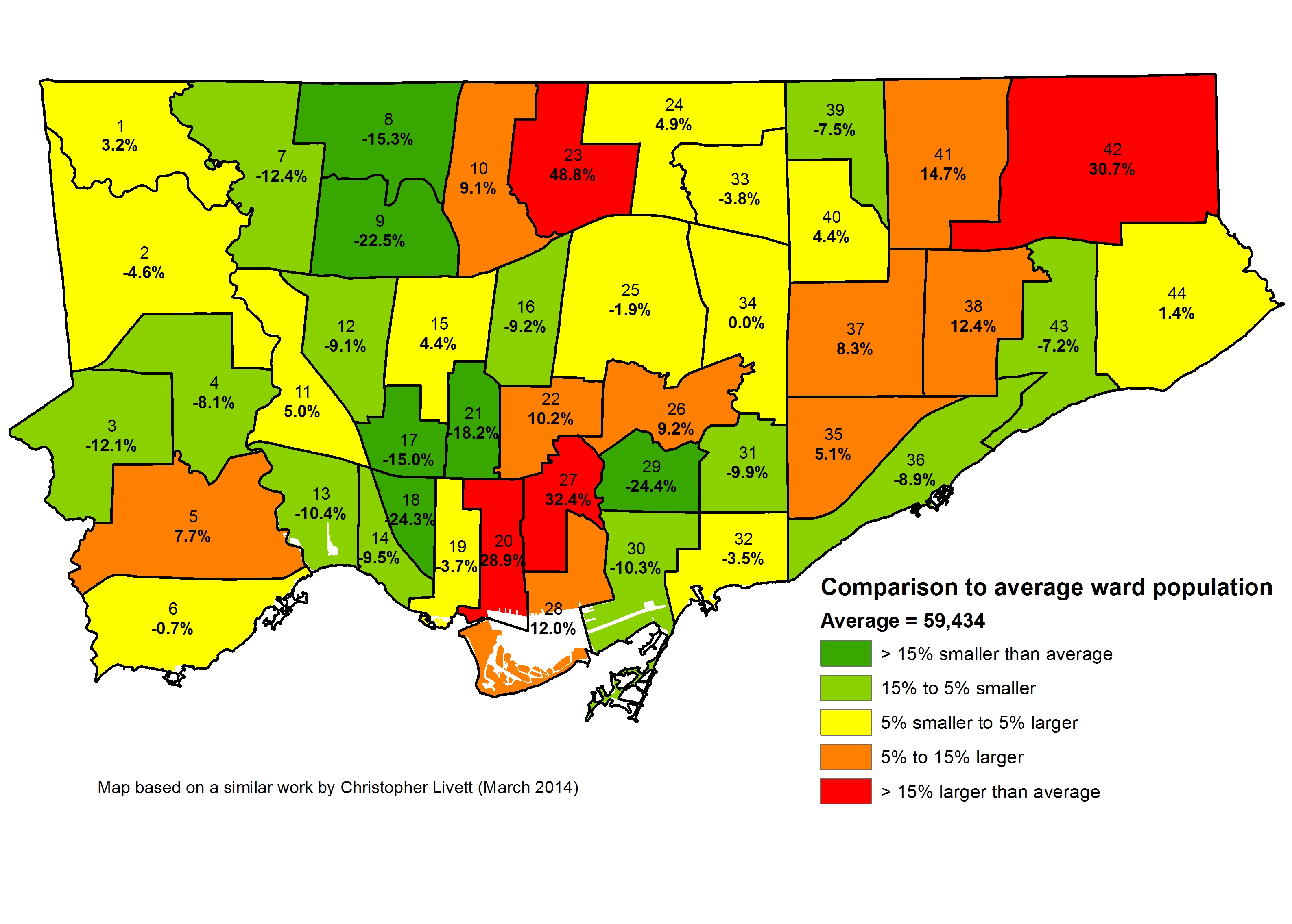
    The City of Toronto is in the process of reviewing the ward boundaries. This is an overlooked and much needed initiative. Due to population increases in central Toronto, North York and in Scarborough, parts of the city are unrepresented at City Hall. Some councillors are overworked with development proposals in their wards, while other parts of the city are relatively quiet.

    While some will argue for fewer politicians (the idea has a populist appeal), I would like to see more city councillors, elected by ranked ballot (which Mayor John Tory supports), to best serve the needs of our diverse and dynamic city. Based upon the population from 2011 census, Wards 20, 23, 27, and 42 are the most underrepresented at City Hall; Ward 42 includes the new Morningside Heights neightbourhood, while condominium construction have swollen the number of residents in Wards 20, 23 and 27. Simply put, the boundaries have to be changed to provide more equal representation. Ward representation 2011 census Map of how each ward is under-represented or over-represented in Toronto, map based on one previously created by Christopher Livett

    The city’s review process, which you can find more about here, is being conducted by independent consultants, so far free of political influence. Though the first round of public consultations have already occurred, there will be further opportunity to participate in the development of ward boundary options. There has yet to be a decision as to how many councillors Toronto should have going forward, or what the boundaries will look like. The committee will report to city council in early-mid 2016 with their recommendations, giving plenty of time before the next election, which will be held in October, 2018.

    (more…)

  • Mapping an accessible TTC

    IMG_3898

    Last week in Torontoist
    , I wrote about the challenges of getting around on the TTC for passengers who rely on mobility devices, such as wheelchairs. Most of us never think about this problem unless we’re directly affected by the consequences of an inadequate system, as I was after a cycling injury in 2012.

    But for TTC users with mobility disabilities (or even passengers with strollers, wheeled carts, or luggage), it’s an issue. While the bus system is (mostly) fully-accessible, the backlog in the delivery of new streetcars and the installation of elevators in subway stations leaves the system failing many of its riders. The alternative, Wheel-Trans, is also underfunded, inconvenient and useless for last-minute travel plans.

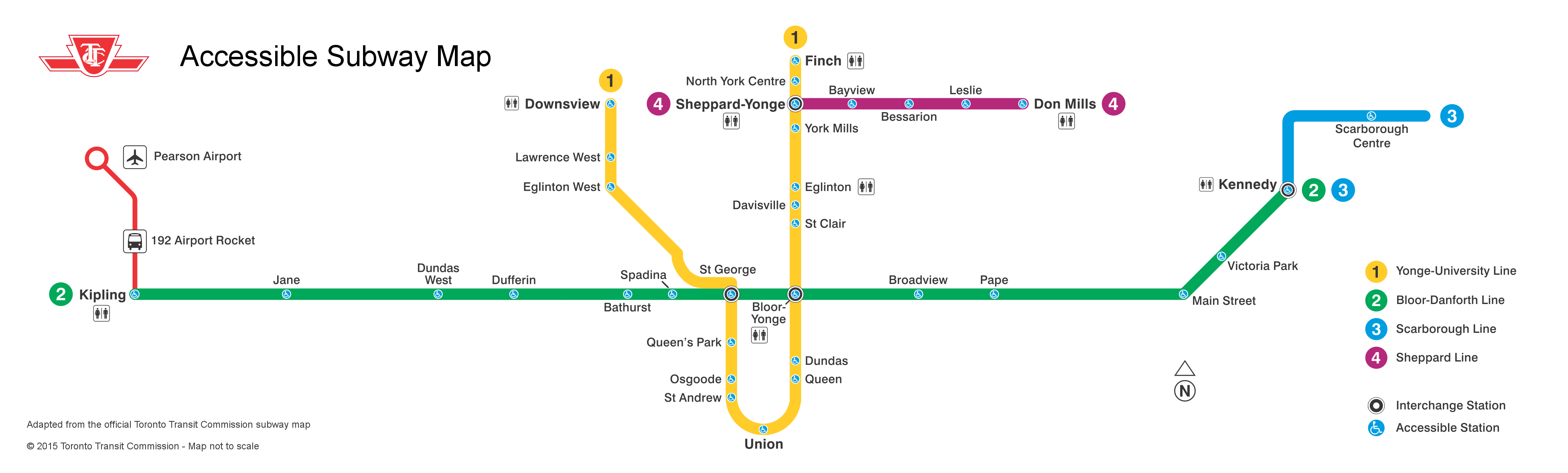
    Here’s what the subway system looks like if you require the use of elevators to navigate the system:

    accessible map - now 2015

    By 2016, only one more station  — St. Clair West  — will be equipped, by 2017, Wilson, Ossington, Coxwell, and Woodbine (and hopefully the Spadina Subway Extension to Vaughan Centre, with its six new fully-accessible stations, will open by then) will follow. But there’s not enough funding to make the entire system accessible by 2025, the deadline set by the Accessibility for Ontarians with Disabilities Act (AODA). Seventeen stations, including Islington and Warden, remain unfunded.

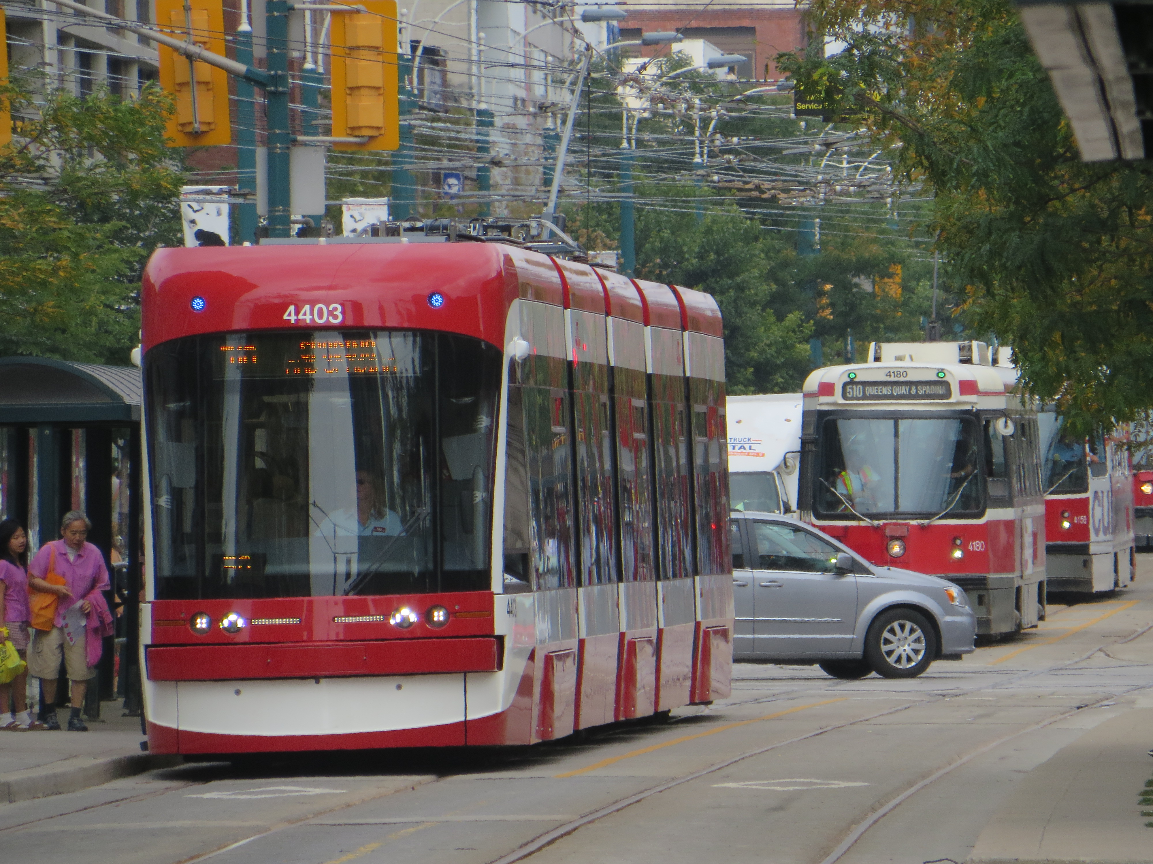
    The entire bus fleet is accessible, though not all bus stops are (the TTC requires a solid, concrete or asphalt place to deploy the ramp or lift, and room for the passenger to board; some suburban stops without a bus pad, or narrow urban sidewalks make loading a passenger in a wheelchair difficult). The first four low-floor streetcars are operating on Spadina Avenue, 200 more are still to be delivered. By now, the Spadina, Bathurst and Harbourfront cars were to have been fully-equipped with the new trams.

    In the meantime, the few bus routes that operate in the central core don’t have many accessible connections; east-west travel is particularly difficult. For example, the 47 Lansdowne bus is inaccessible from either subway station it services (Lansdowne and Yorkdale), and offers no barrier-free transfers south of Dupont Street. The map below shows this problem:

    TTC - Downtown v3 Crop

    Elevators at Ossington would connect the subway with three accessible bus routes, including the 94 Wellesley, a useful east-west alternative. (The 94 serves four subway stations and enters three of them, not one is equipped with elevators.) Meanwhile, both Toronto Western and St. Joseph’s Hospitals are isolated from the accessible transit network.

  • Mapping the City’s Bike Network Gaps

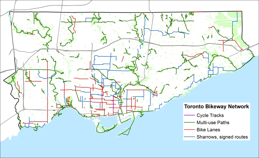
    Bike-Routes-WO-GapsToronto’s Bikeway Network, as of January, 2015
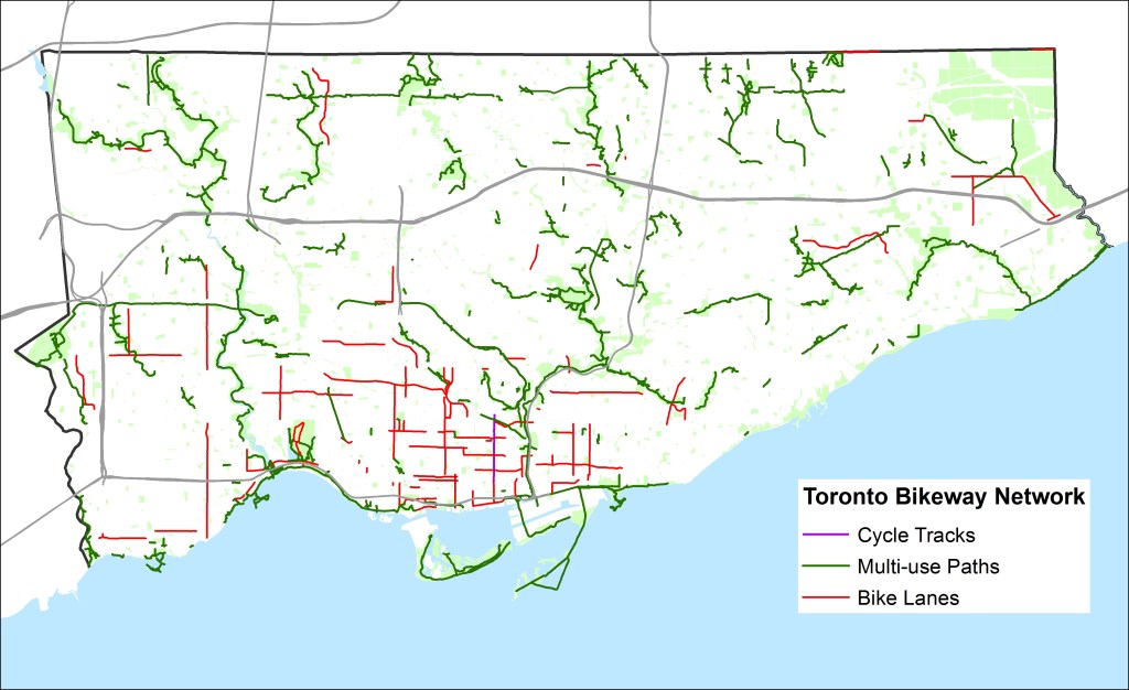
    Over at Torontoist, I posted a short article about the gaps in Toronto’s cycling infrastructure. You can read it here. What follows is a quick summary and some more thoughts (and another map, showing the bikeway network without the sharrows and signed routes without bike infrastructure).

    Toronto’s bikeway network is composed of multi-use paths (off road trails in parks and ravines, shared with pedestrians), cycle tracks (separated bike lanes like those on Sherbourne), bike lanes and contra-flow bike lanes (painted bike lanes without separation; I don’t consider the flex-posts on Adelaide, Richmond and Wellesley to be proper separations — see this Metro Toronto article about a garbage truck entering the bike lane and destroying these flimsy plastic markers). The city also considers other signed bike routes (usually quiet residential and collector streets without heavy traffic) and sharrows to be part of its bikeway network, but I don’t.

    Bike Routes - WO Gaps, sharrowsToronto’s Bikeway Network, as of January, 2015, with the sharrows and signed routes removed
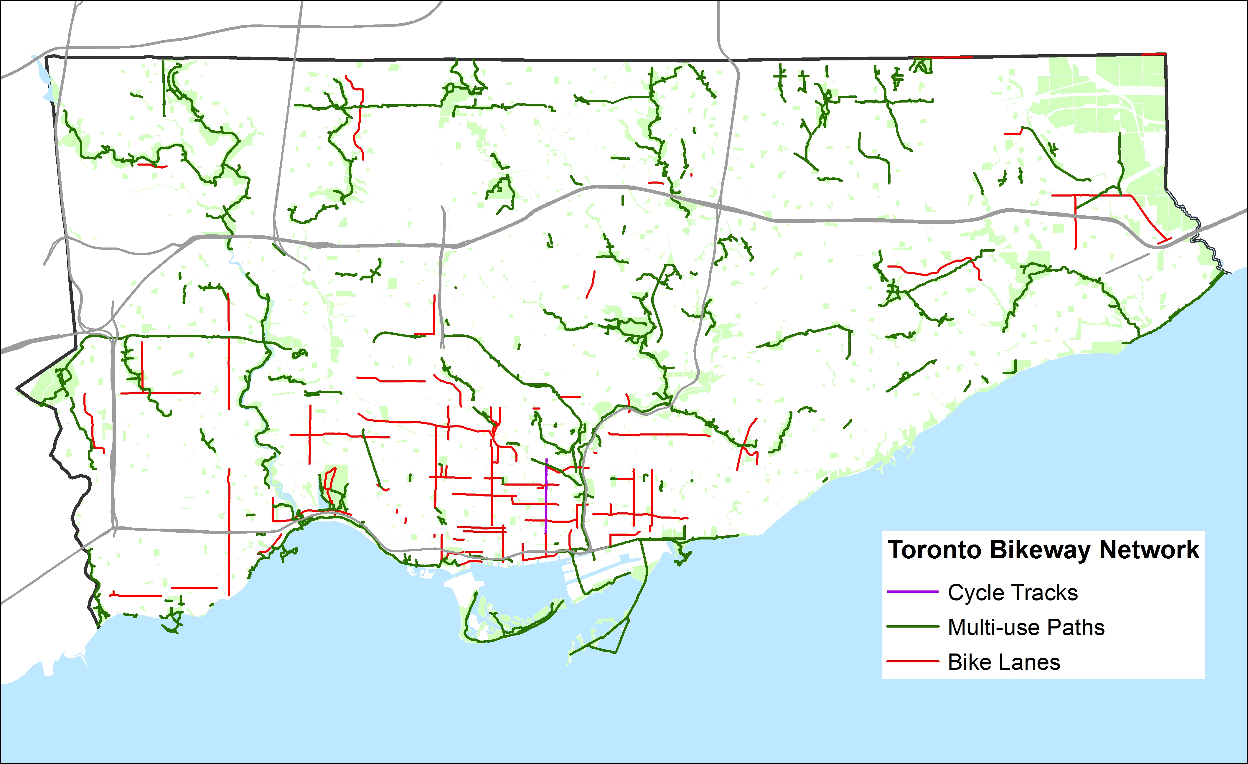
    When the sharrows and signed routes are eliminated, Toronto’s bikeway network looks very thin, especially outside the downtown core. Furthermore, most multi-use trails (shown in green) are not cleared in the winter (the Martin Goodman Trail the only exception) and many are unlit; they are not the safest options for women or vulnerable users.

    Below, I show some of the gaps in the existing network; where bike lanes and multi-use trails should be connected to create at least a complete network of bike-friendly routes across the city. Several circle routes are slowly coming together (via the Humber, Don, Rouge, Highland Creek and east-west hydro corridors) but there are many gaps that need to be closed to complete these circuits. The Waterfront trail is a disconnected labyrinth in Scarborough; I’d like to see a new multi-use trail beneath the beautiful Scarborough Bluffs to connect the trail to the parks below otherwise isolated and inaccessible without a car.

    The gaps in the existing bikeway network show the shortcomings in cycling infrastructure to support a minimum grid of safe bike routes in the suburbs, which would be mostly built on city streets, not in ravines or hydro corridors. Note that there are only three designated places to cross Highway 401, which is a much greater barrier to more Torontonians than the Gardiner Expressway is downtown.

    For his part, during the 2014 campaign John Tory said that he would support bike lanes where it was “sensible.” But he did not define what that meant or provide a timeline for specific goals. Given the number of bike-unfriendly councillors returned to city hall; one of whom is now John Tory’s deputy mayor, I don’t have too much confidence in seeing much more than a few downtown projects and more multi-use trails constructed in the next four years.

    Bike-Routes-Gaps
    Some of the many gaps in the existing bikeway network

  • The genesis of Mayor John Tory’s SmartTrack

    I was recently browsing Urban Toronto‘s forums (a great resource if you’re interested in keeping up with construction updates and development proposals here in Toronto), when I came across a post written by “AlvinofDiaspar” in a thread discussing SmartTrack.

    Alvin’s post linked to an interesting report written by the Strategic Regional Research Alliance, a consulting group based in Toronto that I had never heard of until recently. The report, entitled “The Strategic Case for the Regional Relief Line,” was published in October 2013, just before the mayoral race began for the 2014 election.

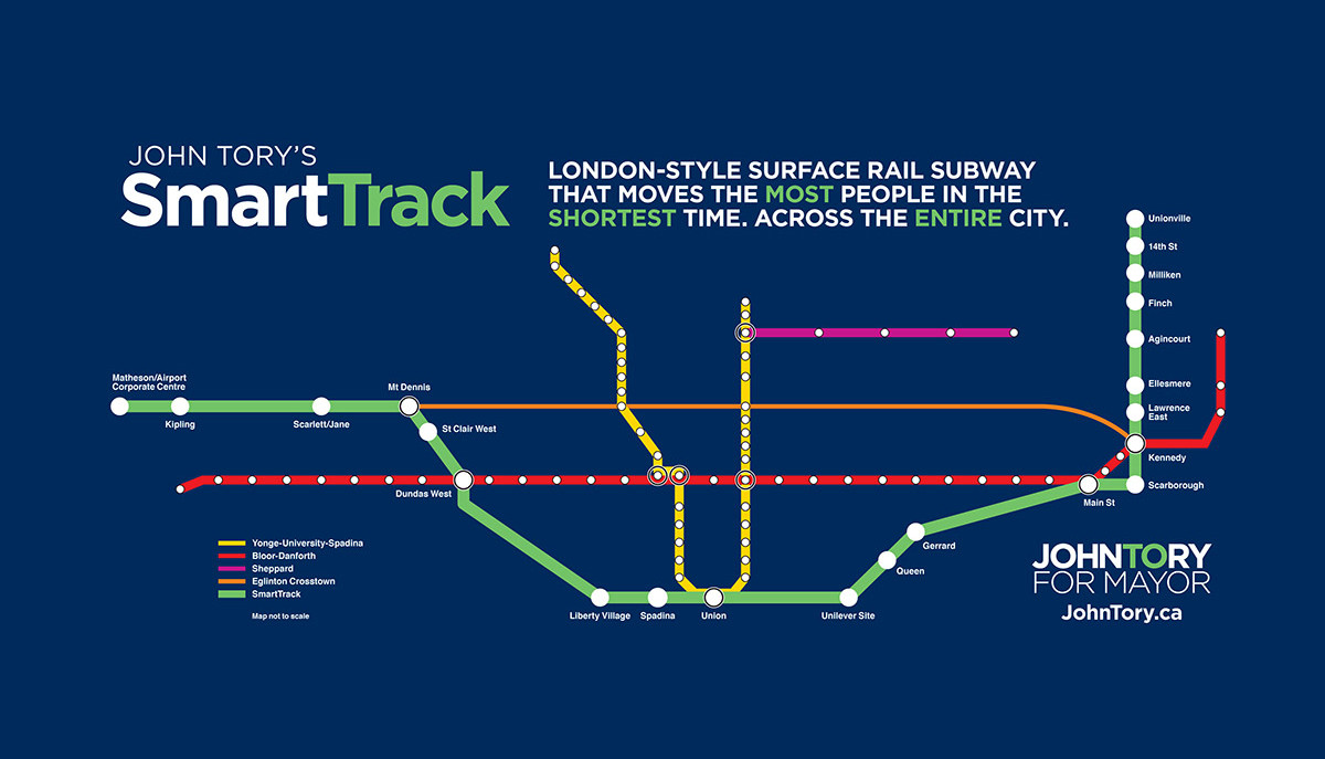
    John Tory unveiled his “SmartTrack” plan, promising a “London-Style surface rail subway” (whatever that meant), on May 26, 2014. The transit service, using frequent, electric multiple unit trains (like those used for commuter/regional transport in many European cities) would mostly follow existing railway corridors from Markham to Mississauga, via Union Station.

    On the east end, the route would follow GO Transit’s Stouffville Line from Union Station as far as Unionville Station, making more frequent stops, serving the Unilever plant (which will be replaced by a massive commercial/office redevelopment by First Gulf, first announced in 2012), as well as additional stops at Queen St East, Gerrard/Carlaw, Lawrence East, Ellesmere, Finch and 14th Avenue, in addition to existing GO Transit stops at Danforth/Main, Scarborough Junction, Kennedy/Eglinton, Agincourt (Sheppard), Milliken (Steeles) and Unionville.

    To the west, the line would follow GO’s Kitchener Line from Union Station as far as Mount Dennis (Eglinton Avenue, near the western terminus of phase one of the Eglinton-Crosstown LRT), with stops at Spadina, Liberty Village, the existing GO/UP Express station at Bloor, and at St. Clair Avenue. At Mount Dennis, the SmartTrack corridor follows a routing via Eglinton Avenue into Mississauga’s Airport Corporate Centre office district, which of course has no existing rail infrastructure to capitalize on.

    Tory promised to have SmartTrack operational in seven years, by 2021, putting other approved and/or proposed transit projects (the Downtown Relief Line, the Sheppard East and Finch West LRTs, among other plans) on the back burner.

    smarttrack_fbJohn Tory’s “SmartTrack” map

    Back in 2014, transit observers were taken aback by this new “bold” transit idea (John Tory kept using that word to describe SmartTrack), as his campaign had recently taunted Olivia Chow’s hesitancy to prioritize the Downtown Relief Line (DRL) in her transit platform. At the time, Chow, the presumed front runner in the mayoral race in April 2014, promised to increase TTC bus service and build the Scarborough LRT while planning for the DRL continued.

    The DRL is a long-proposed subway line under review by the City of Toronto and by Metrolinx that would connect downtown Toronto to the Bloor-Danforth Line east of the Don River, thus relieving the the Bloor-Yonge subway interchange from overcrowding, while offering improved transit access to east end Toronto, and addressing overcrowding on Yonge subway trains. Further extensions to the north, towards Thorncliffe Park, Flemingdon Park and Don Mills, would re-direct many current and potential transit riders from the Yonge Subway, allowing for an extension of that line from Finch to Richmond Hill.

    But to some degree, Tory’s promise of frequent, regional electric rail on GO’s corridors dovetailed with provincial plans for electrification of part of GO’s services and the Airport Rail Line (now branded as the Union Pearson Express). Improved services on GO’s corridors, if paired with fare integration with local transit (GO’s fares are very expensive for short trips), would provide useful rapid transit to many areas not served by the subway, and could provide some relief to the existing subway network. John Tory was endorsed by many provincial cabinet ministers; it appeared that he had the support of the Liberal government itself, though Premier Kathleen Wynne never endorsed any mayoral candidate directly.

    The only hint of this SRRA report that I could find in the mainstream media was in an interesting article written by Tess Kalinowski, the transportation reporter at the Toronto Star after Tory’s win on October 27, 2014. In an article published on November 17, entitled “The evolution of SmartTrack,” a report entitled “The Business Case for the Regional Relief Line” was mentioned. Also mentioned in the article was John Duffy, a political strategist who worked on the provincial Liberal leadership campaign of former transportation minister (now environmental minister) Glen Murray, and had ties to Wynne’s leadership and election campaigns. Kalinowski wrote that Duffy also was acquainted with Iain Dobson, a property developer and Metrolinx board member. Other people involved in putting SmartTrack together and mentioned in the article were the Canadian Urban Institute’s Glenn Miller (who is listed as a SRRA contact on its website, as is Iain Dobson, a real estate executive and Metrolinx board member), former Toronto chief planner Paul Bedford and businesswoman and urban expert Anne Golden.

    Transit advocate and friend Steve Munro picked up on this report before I had – you can read his posts which are more detailed and far better than my short analysis in this post:

    Munro: The Dubious Planning Behind SmartTrack Part I Part II Part III

    It’s unfortunate that John Tory decided to make this concept the centrepiece of his transit platform. Easily, the biggest flaw, mentioned by others, including Steve Munro and mayoral rival Olivia Chow, is the Eglinton section between Mount Dennis and the Airport Corporate Centre. The corridor already had a proposed rail transit project, the western leg of the Eglinton-Crosstown LRT line, a project first proposed in 2007 as part of a larger city-wide LRT plan known as Transit City, and confirmed in 2009 when the provincial government announced funding for it and three other LRT lines. (In 2010, funding was deferred for the section west of Weston Road). The once-available right-of-way that would have allowed for a surface-running heavy rail transit project was already disappearing.

    But in the SRRA-authored report, we see why Tory went along with the problematic Eglinton routing, rather than having SmartTrack continuing along the GO Kitchener/UP Express corridor towards the transit desert of northwest Toronto. It was part of a larger plan to connect suburban office parks to Downtown Toronto.

    The Regional Relief Line, as envisioned by the SRRA, would have included a third phase, from the Airport Corporate Centre to Meadowvale Business Park, another large, although sprawling, employment centre near Highway 401 and Mississauga Road. The “Phase Three” of this proposed regional rail route would follow Highway 401 on a new alignment.

    srra mapThe map from the SRRA report, published on page 4. Note the use of Google Maps to create the map.

    The SRRA planning exercise appears to be one where well-educated planning experts were engaged in a game of “connect the dots.” Sure, the Regional Relief Line connected several major employment nodes in Markham, Toronto, and Mississauga, with the nodes in Mississauga lined up along Highway 401. But this error on page 6 of the report makes me wonder how many of the facts and assumptions the authors simply got wrong or didn’t fact-check:

    This phase will take a little longer to complete than the Markham phase because there are no tracks on the section from Mt Denis to the Airport Corporate Centre. This right of way will take longer to design and obtain approval in an EA process. It is owned by the Province and was intended to be an expressway. There is ample room for the dedicated right of way.

    In fact, the Richview Corridor, the right of way mentioned, was owned by the city, not the province, reserved in the 1960s for an expressway linking Highways 401 and 427 to the proposed Highway 400 extension, part of a much larger highway plan for Metropolitan Toronto. The 400 extension was cancelled and the at-grade Black Creek Drive was built instead; the Richview lands along Eglinton Avenue West in Etobicoke remained dormant for decades. But in 2011, the city started selling off the land for residential development, making the right of way unusable for any transportation corridor. (This did not matter in plans for the Eglinton-Crosstown LRT connection to the airport; there was still room to build a median LRT corridor along this section.) In 2013, pre-eminent local transit and planning experts should have been aware of this development and be able to identify the proper owner of this former right of way.

    It also strikes me as a little backwards looking to link auto-dependent office parks together with a new transit line, especially without a detailed origin-destination study. Shouldn’t urban planners be promoting dense urban employment clusters in areas well-served or potentially well-served by transit? Does it make sense to build expensive transit lines to serve low-density office complexes that come with large parking lots and garages, such as those in Mississauga’s Airport Corporate Centre? Or am I confused?

    In December 2014, mere weeks after Tory’s election, Council voted 42-1 to accelerate the work plan for the rail line, awarding up to $750,000 for early analysis and modelling work. The consultants awarded the funds? A group from the University of Toronto and Strategic Regional Research Associates. In February, council approved an additional $1.65-million towards studying SmartTrack, at least taking a closer look at the Eglinton West section of the corridor.

    To me, it seems just a little bit odd that Tory’s campaign advisers were awarded this contract to study a project, that until Tory’s election, wasn’t even on any transit planning maps. Steve Munro picked up on this as well, questioning whether  Iain Dobson, a member of the Metrolinx Board, has a conflict of interest due to his involvement with the SRRA and a member of the Advisory Board to the University of Toronto Transportation Research Institute. After all, Metrolinx is supposed to be the expert, disinterested provincial agency charged with evaluating and implementing various transit plans. Meanwhile, the need for a Downtown Relief Line hasn’t gone away.

    Tory and his connections in academia and the private sector have managed to change the course of Toronto’s short-term transit planning, and I can’t help but feel a bit suspicious of the behind-the-scenes planning that went into SmartTrack. This is a story very much worth following.

  • Streetcars of desire: why are American cities obsessed with building trams?

    IMG_5868-001

    Back in January, I posted my thoughts on some of the new streetcar systems being built in the United States after visiting Detroit, Cincinnati, Atlanta and Tampa on a Florida road trip. I soon cross-posted the article to Spacing, where it got more interest.

    Not long after the Spacing cross-post was published, I got a message from Guardian Cities. The editor, Mike Herd, asked me if I was interested in writing a similar piece, expanding on my post and discussing the difference between the streetcars in my hometown of Toronto, and the new systems being built in the US.

    It was an interesting experience, and one where I came to appreciate the role that content editors have. The article went through several major changes until we were all happy with the final product.

    You can read my Guardian Cities article, which was published on Friday, here:

    Streetcars of desire: why are American cities obsessed with building trams?

  • Mapping the 2014 Toronto Election: Wards 43 and 44

    Last, but not least, in my series of posts examining the results of the  Toronto municipal election of October 2014, are Wards 43 and 44, Scarborough East.

    I started these series of maps of the 2014 Toronto election as a few tweets. To me, it was a simple, interesting exercise. At first, I only sought to map the most interesting wards, where there were competitive races for city council – wards where the incumbent wasn’t running again, or where great candidates like Alejandra Bravo, Russ Ford, Lekan Olawoye, Dan Fox, and Andray Domise, were taking on established councillors and offering a better alternative to local voters. After requests to have a place to have these maps available somewhere, I resolved to set up a blog and to map every poll. It has taken me a bit longer than I expected, but I hope that these maps become useful between now and the 2018 election.

    While my politics certainly lean left, and my commentary on my blog at times pointed, all the maps I created are available to everyone. Despite my cynicism, I genuinely believe most people run for public office for the right reasons. Putting your name on the ballot takes courage; making a serious run for any elected office, even school trustee, is a long, difficult, exhausting, and expensive undertaking. I respect nearly every candidate who make that effort, regardless of their political leanings.

    And now, with the ward maps done, I’ve thought of more ideas to pursue in the near future. I’m interested in voter turnout; with esteemed Ryerson Professor Myer Siemiatycki, I co-wrote a study commissioned by the Maytree Foundation studying voter turnout in previous municipal elections. With poll-level data, it would be most interesting to look at voter turnout by housing type (such as TCHC vs. private rentals vs. condominium residences, for example) and other local determinants.


    Ward 43

    Ward 43 is represented by Paul Ainslie, a centre-right leaning councillor who I’ve come to respect. Ainslie was picked Chair of the Government Management Committee (and a member of Mayor Rob Ford’s executive committee) after the 2010 election.

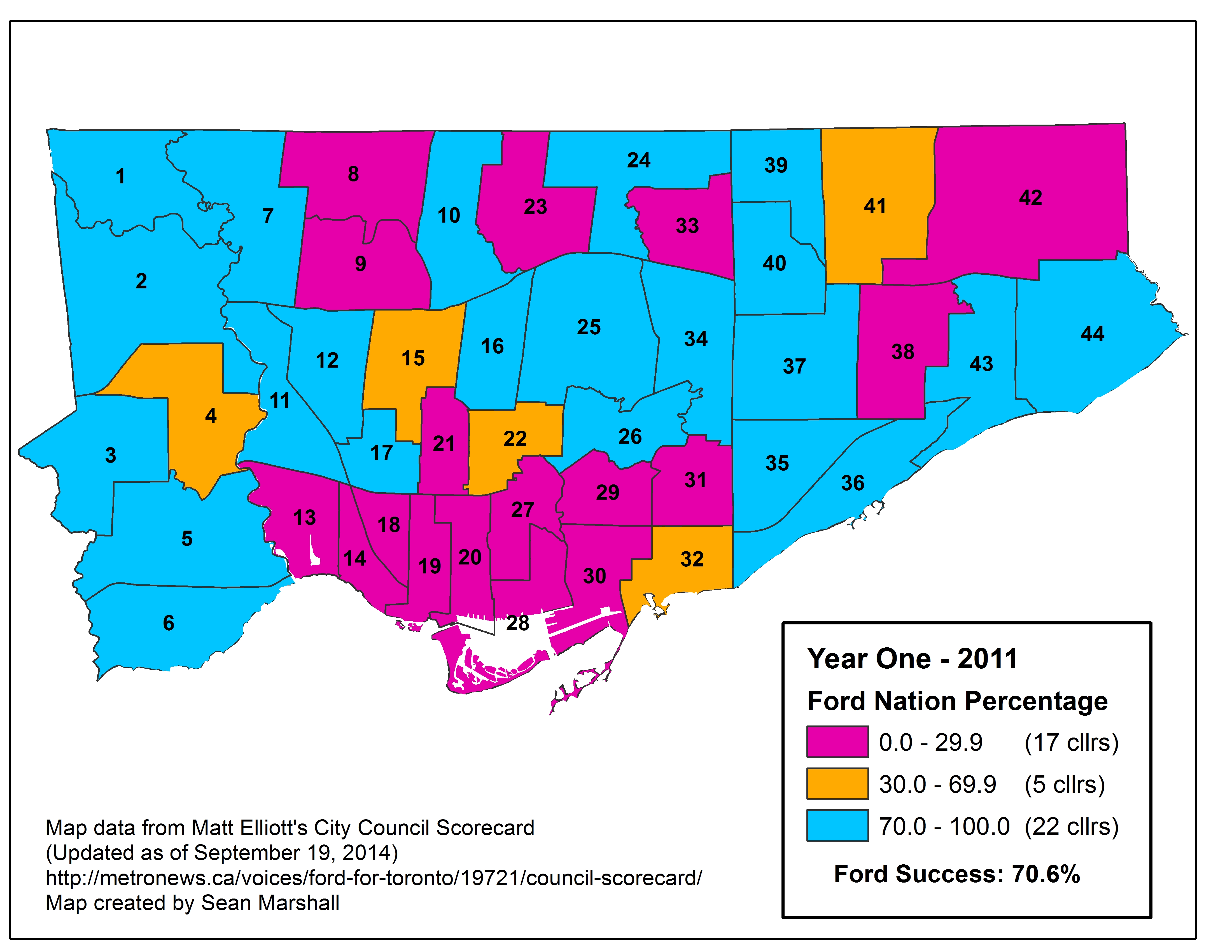
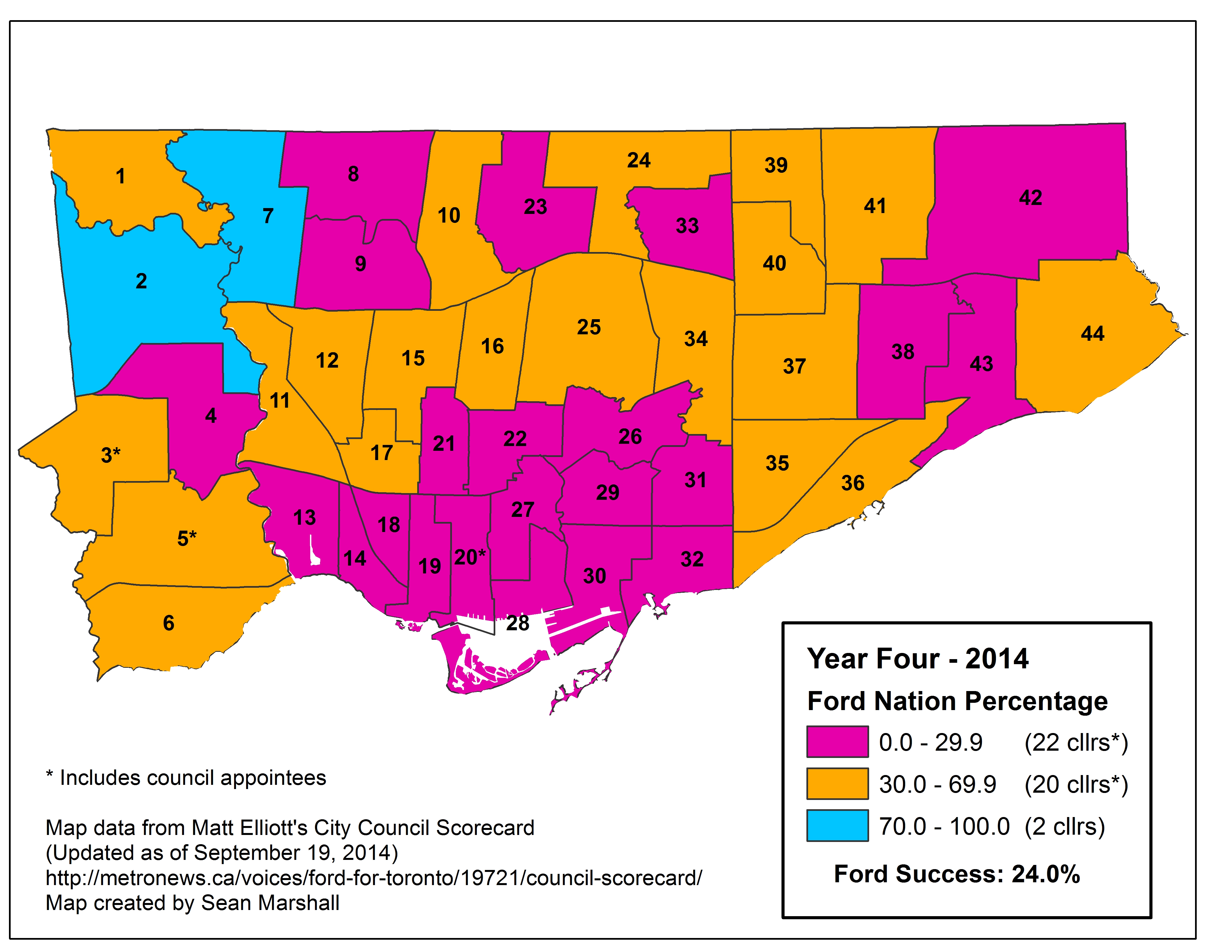
    But unlike most Scarborough politicians, Ainslie parted with Ford on many issues. In 2011, Ainslie voted 97% of the time with Ford; but by 2013, he only voted 40.5% of the time with Ford. In 2014, Ainslie’s “Ford Nation” score (as developed by Metro columnist Matt Elliot) was only 20%, a difference of 77%. This was the greatest drop in Elliot’s “Ford Nation Percentage”score. In a CBC article dated October 15, 2013, Ainslie started to “butt heads” with Ford early that year “over budget issues.”

    That October, after the first Ford crack scandal hit but before Rob Ford’s November meltdown that ended up seeing Norm Kelly assume most of Ford’s responsibilities, Ainslie resigned from Ford’s executive. Ainslie supported the Scarborough LRT replacement project (which would include an extension to Progress Road and Sheppard Avenue) instead of the Bloor-Danforth Subway extension. For his actions, Rob Ford then recorded a “robocall” message to Ward 43 residents that read:

    “It was extremely, extremely unfortunate that your councillor, Paul Ainslie, was the only Scarborough councillor who did not listen to his constituents, and voted against the Scarborough subway. In fact, he led the charge against building subways in Scarborough; unfortunately it has led to his resignation from my executive committee. We are moving forward with a team who support the mandate Toronto taxpayers gave me…”

    The calls were made from Ford’s own City Hall telephone number. Eventually, Mayor Ford was forced to apologize on the council floor in 2014, in one of many rulings the City’s integrity commissioner made against the mayor. Despite Ford’s outrageous claims, Ainslie regularly engages with his constituents, including discussing the subway/LRT issue.

    Ainslie’s position on the Scarborough Subway/LRT dovetailed with the transit platform of mayoral candidate David Soknacki, who represented Ward 43 before Paul Ainslie was elected in 2006. Ainslie got his start at city hall as Councillor Soknacki’s executive assistant. (In February 2006, Ainslie was appointed to council to represent neighbouring Ward 41, filling in for former councillor Bas Balkisoon, who was elected as a Liberal MPP in a provincial by-election. Ainslie’s run for Ward 43 councillor later that year was controversial, as appointed councillors are typically expected not to run in the next general election.)

    As in neighbouring Scarborough Ward 36, most polls on the Lake Ontario shoreline in Ward 43 voted for John Tory. Conversely, all but one poll north of the GO Lakeshore East Line, a City of Toronto long term care home near Scarborough Centenary Hospital, voted for Doug Ford. Ford came in first place in Ward 43, netting 45.7% of the vote, while Tory came in second place with 35.3%. Olivia Chow only took 15.5% of the vote.

    Paul Ainslie handily won re-election in 2014 (despite Rob Ford’s robocalls) with 74.3% of the vote. Second place candidate Mark Harris had the vote of only 10.5% of the electorate.

    2014 Election - WARD 43 Mayor
    Poll results of the mayoral race in Ward 43

    Ward 44

    2014 Election - WARD 44 Mayor

    Poll results of the mayoral race in Ward 44

    East of Highland Creek, the residential areas between Kingston Road/Highway 401 and the lake mostly voted for Tory, continuing Tory’s pattern of coming in first in middle and upper-income polls in Scarborough that straddle Lake Ontario. West of Highland Creek; Polls 027, 028 and 029, while also bordering Lake Ontario, are for all intents and purposes inland; the GO Lakeshore East line (CN Kingston Subdivision) separates residential areas to the north with the parks, factories and municipal facilities (water treatment plants). These polls, which supported Doug Ford by wide margins, are located in the West Hill Neighbourhood Improvement Area (the new nomenclature for what used to be called “priority neighbourhoods); Poll 027 includes the Danzig Street TCHC community where one of Toronto’s worst mass shootings occurred on Monday, July 16, 2012. Most polls north of Kingston Road also voted for Doug Ford.

    Ford came in first place in Ward 44, taking 44.1% of the vote to Tory’s 38.6%. Chow only got 14.9%. As in Ward 43, Tory won the advance poll by a comfortable margin despite coming in second place in both wards.

    Ward 44 also had one of the closest council races as three viable candidates sought to unseat 71-year old Ron Moeser, who left everyone guessing whether he’d run for council again despite a poor attendance record attributed to health concerns. Moeser has long been a dead weight on council, quite possibly its least active member. Moeser was first elected to Scarborough council in 1988, he has been a city councillor since then, except betweeen 2003 and 2006, when Gay Cowbourne defeated him; she did not run again in 2006 and Moeser took back the seat.

    In the 2010 election, Moeser narrowly won in Ward 44, taking 47.4% of the vote to second-place Diana Hall’s 46.1%, a difference of 284 votes.

    In 2014, the Toronto Star endorsed Hall, Cowbourne’s former executive assistant, describing her as a “thoughtful conservative” while NOW Magazine halfheartedly endorsed Amarjeet Shhabra, explaining that the main reason to vote for her was to defeat Moeser. Shhabra, a union organizer, had the Labour Council’s endorsement.

    It’s too bad the Toronto Star and NOW overlooked Moeser’s strongest challenger.

    Moeser unfortunately won in a crowded field of 15 candidates; several of whom had name recognition and organized campaigns. But Moeser won just 25.7% of the vote in the 2014 election, 3769 fewer votes than in 2010. But was Jennifer McKelvie, an environmental scientist and adjunct professor at Ryerson University, who came closest to defeating Moeser, taking 23.4% of the vote, a difference of 572 votes. Hall came in third with 22.2%, and Chhabra came in fourth, netting 11.4% of the vote. McKelvie came in first in 14 election day polls as well as the advance poll, Moeser won in 16 polls, Hall in 5. Most polls that supported Doug Ford the strongest stuck with Moeser for council, while polls where Tory came in mostly voted for Hall or McKelvie, the remainder might have voted for Moeser, but by very small margins.

    Had there been a less crowded field, I suspect that Moeser would not have won in 2014.

    (Interestingly, the advance polls reflected the election day results, there would be two more women on Toronto City Council; Alejandra Bravo also won the advance poll in Ward 17, but couldn’t dislodge Cesar Palacio.)

    McKelvie, who was running for public office for the first time, has some impressive credentials; had she won, she’d be great fresh voice at City Hall. But in several wards, including 3, 5, and 26, the second-place candidate in the 2010 election went on to prevail in 2014. This should be welcome news for Jennifer McKelvie, who I hope will be interesting in running again.

    2014 Election - WARD 44 Cllr

  • Mapping the 2014 Toronto Election: Wards 41 and 42

    I was hoping to have this series of analyses of the 44 wards complete last week, however many things got in the way. But with my life getting back to normal, and with my eagerness to move on to new projects, I bring you the penultimate post in the series the results of the 2014 municipal election.

    In this post, I look at Wards 41 and 42, Scarborough-Rouge River. Ward 41 is represented by Chin Lee, Ward 42 by Raymond Cho. Despite the Fords’ popularity in northeast Scarborough, neither councillor was much of a support of the Ford agenda in 2011-2014. Raymond Cho, despite his Conservative leanings, voted with Ford less than 20% of the time, while Chin Lee voted with Ford 36% of the time, according to Matt Elliot’s Council Scorecard.

    In Ward 41, which is located north of Highway 401, between the GO Stouffville Line (CN Uxbridge Sub) and McCowan/Markham Roads, Doug Ford came in first place in all but one poll, 014, where Olivia Chow won. Poll 014 represents one of several Yee Hong Centres for Geriatric Care.

    In Ward 42, which covers the Malvern and Morningside Heights neighbourhoods, as well as the Toronto Zoo and much of Rouge Park, Doug Ford came in first place in every single poll, doing best in the Malvern neghbourhood, but with less support in the newer subdivisions of Morningside Heights to the north of Finch Avenue.

    John Tory did not win a single poll in either Scarborough-Rouge River ward.

    2014 Election - WARD 41 MayorPoll results of the mayoral race in Ward 41

    2014 Election - WARD 42 Mayor
    Poll results of the mayoral race in Ward 42

    (more…)

  • Mapping Which Neighbourhoods Could Be Most Affected by TDSB School Closures

    Last week the Toronto District School Board released a much-anticipated list of schools under review for closure as the beleaguered board looks to reduce expenses and raise funds for capital projects.

    Over at Torontoist, I take a look at which neighbourhoods are most affected by this review, and discuss the impacts that school closures might have. Please leave comments in that thread.

  • Mapping the 2014 Toronto Election: Wards 39 and 40

    I almost called this post “Everybody loves @norm” after the popular former Deputy Mayor, Norm Kelly, who represents Ward 40 on  Toronto City Council.

    In this latest installment of my (nearly complete) series of posts on the results of the 2014 municipal election, I come to Wards 39 and 40, Scarborough-Agincourt. The provincial/federal riding of Scarborough-Agincourt is a nice rectangular shape, bounded by Steeles Avenue to the north, Ellesmere Road to the south, Victoria Park to the west, and the GO Transit Stouffville corridor (formerly the CN Uxbridge Subdivision) railway to the east. This rail corridor is proposed as the route of Mayor John Tory’s “SmartTrack” transit plan. However, the boundary between Wards 39 and 40 is a bit jagged, with Finch and Birchmount Avenues and West Highland Creek forming the boundary. This results in an odd panhandle in Ward 39, as it includes only two apartment towers south of Sheppard Avenue.

    Mayoral race

    In the mayoral race, Doug Ford came in first place in both wards, netting 50.1% of the vote in Ward 39 and 48.4% in Ward 40. John Tory came in a distant second place in both wards, with 26.9% of the vote in Ward 39 and 30.7% in Ward 30. Third-place Olivia Chow got between 17 and 18% in both wards.

    2014 Election - WARD 39 MayorPoll results of the mayoral race in Ward 39

    In Ward 39, Doug Ford came in first place in all but 4 polls. John Tory came first in three, all representing condominium towers on Bridletowne Circle (in the Finch/Warden area). Olivia Chow one one poll, 028, a condo tower on Kennedy Road near McNicoll Avenue. Doug Ford came in first place in all seniors’ homes in the ward, including the large Yee Hong Centre. While I am not terribly surprised, it is worth noting how a prominent Chinese-Canadian immigrant could not obtain much support in a ward with a large Chinese-Canadian community.*

    2014 Election - WARD 40 Mayor Poll results of the mayoral race in Ward 40

    Like Ward 39, Doug Ford came in first place in all but four polls in Ward 40, with Tory taking three, and Chow one. Tory did the best in Polls 020 and 021, the Shepherd Village retirement and assisted living community on Sheppard Avenue; he also came first in Poll 015, which doesn’t seem much different than its neighbouring Ford-voting subdivisions. Doug Ford did the best in Polls 014, a rental tower on Chichester Place and 030, an older condominum tower on Palmdale Place.

    Council races

    Ward 39, represented since 2003 by accountant and former Catholic school board trustee Mike Del Grande, was an open race in 2014 with Del Grande’s announcement in February that he was not seeking re-election. On April Fool’s Day, April 1, Liberal MP Jim Karygiannis announced his resignation from federal politics to run for the council seat.

    Karygiannis’s announcement was a bit unusual. while it’s not rare for a sitting federal or provincial politician to run for municipal office, usually it’s to run for mayor (the newly elected mayor of Brampton, Linda Jeffrey, was a Liberal MPP and prominent cabinet minister when she resigned to run there; George Smitherman was another powerful provincial cabinet minister who ran for mayor of Toronto, but lost to Rob Ford in 2010). His claim was it was spend more time with family; speculation was that Liberal leader Justin Trudeau didn’t care for the veteran controversial and socially conservative MPP; the feeling was likely mutual.

    But with name recognition and a local political machine, Karygiannis pretty much had the advantage of any council incumbent, especially against relative unknowns Franco Ng and Cozette Giannini. While the Toronto Star endorsed Ng, NOW magazine endorsed Giannini, Karygiannis won in a landslide; taking 58.9% of the vote and all but three polls. Second-place Franco Ng netted only 18.1% of the vote (and came first in two polls), Giannini came in third with 9.8%. Fourth-place Derek Li came first in one poll, though this was a long-term medical institution with a small voting population.

    2014 Election - WARD 39 Cllr Poll results of the council race in Ward 39

    There was no contest in Ward 40, represented by councillor Norm Kelly, who won with an astounding 86% of the vote. But I’m certainly not complaining.

    Kelly is a long-term city councillor, but is also a historian, and taught history at Upper Canada College. He was first elected to municipal politics in 1974 as an alderman on Scarborough council. He was a Liberal MP between 1980 and 1984, losing to the Progressive Conservatives in the Mulroney landslide of 1984. After making an unsuccessful run for mayor of Scarborough in 1985, Kelly turned to real estate before returning to Scarborough council in 1994; he has been a Toronto councillor since the 1997 amalgamation.

    Kelly, a centre-right ally of mayors Lastman and Ford (between 2011 and 2014, Kelly voted with the mayor over 80% of the time), was named deputy mayor in August 2013. This was after Rob Ford’s first pick for deputy mayor, Doug Holyday, resigned after a by-election win in Etobicoke-Lakeshore for the Ontario Progressive Conservatives. (The losing Liberal candidate in that by-election, fellow Etobicoke councillor Peter Milczyn, won in the general election in the June 2014 general election). As Rob Ford’s personal scandals involving drug use and lewd behaviour deepened in 2013; council stripped Ford of most of his powers, transferring them to Kelly in November 2013. Kelly quickly re-established order and decorum to City Hall with humour and grace, and for that, politicians and observers of all political stripes were grateful. Even the lefty NOW magazine endorsed Kelly for re-election in 2014.

    Unfortunately, John Tory picked Denzil Minnan-Wong (who, to put it nicely, is not nearly as well-liked as Norm Kelly) as his lead Deputy Mayor. (Vince Crisanti, Glenn De Baeremaeker, and Pam McConnell were chosen as Tory’s secondary deputy mayors.)

    Given Kelly’s sweep of all polls in Ward 40, there was no need to create a map of the council race here.

    Post script: It’s also worth noting that Wards 39 and 40 were represented at the Toronto District School Board by Sam Sotiropoulos, a homophobic and transphobic individual, whose offenses are nicely summed up by Torontoist in its annual Heroes and Villains feature. Sotiropoulos lost to Manna Wong by 2067 votes. Still Sotiropoulos came in second place, and got 9,621 votes. I hope this can be chalked up to the incumbency factor and that many voters simply do not pay attention to school board politics.

    (Hat tip to Paula Cheung reminding me to include this post script, one of the bright spots of the 2014 election.)


    *It should be noted that Olivia Chow immigrated from Hong Kong and speaks Cantonese, many in Ward 39’s Chinese-Canadian community are immigrants from Mainland China and speak Mandarin. And of course, there are many considerations one makes when deciding who to vote for; as I mentioned earlier, I am not surprised to see Chow do so poorly in Agincourt.