Category: Infrastructure

  • New TTC subway stations have great architecture, but they may not attract enough riders

    IMG_4071-001.JPGVaughan Metropolitan Centre Station

    On Saturday, October 28, the Toronto Transit Commission (TTC) held open houses at three of the six new subway stations set to open on December 17, 2017 when the Line 1 subway is extended to York University and Vaughan. It was a fun afternoon with friends, checking out the architecture and the layout of Vaughan Metropolitan Centre,* Highway 407, and Pioneer Village Stations.

    Some of the station architecture was stunning, and I came away feeling much less skeptical about Vaughan’s commitment to building a new urban district around its station. Most stations along the subway corridor will be well-used. However, I remain critical about the issue of transfers between transit agencies, and the usefulness of at least one station.

    (more…)

  • Some answered questions about Toronto’s next subway extension (updated)

    36354175911_632dc72411_o.jpgYork University Station, August 2017

    Updated October 10, 2017

    Ten months ago, I wrote about some of the unanswered questions about the Toronto Transit Commission’s Line 1 subway extension to York University and Vaughan. At the time, I was concerned about fare integration once the subway opened, especially if suburban GO, YRT, or Brampton Transit passengers headed to York University were required to make new transfers to the subway at Vaughan Centre or Highway 407 Stations.

    We now know the day the six new subway stations will open: Sunday, December 17, 2017. We also know how the TTC, York Region Transit, and Brampton Transit will serve the new extension and York University. And today, we also have some indication of how GO Transit passengers will be affected by the changes.

    YRT Subway Map.jpg
    How YRT and Brampton Transit will serve the Line 1 subway extension
    (from the YRT website)

    On Friday, Premier Kathleen Wynne and Transportation Minister Stephen Del Duca will announce a new co-fare between the TTC and Metrolinx services (GO Transit and Union Pearson Express), to take effect in January 2018. (The Star previously reported that the fare change will take place as soon as the subway extension opens.)

    Transfers from GO Transit or UPX to the TTC will cost $1.50 for passengers using Presto cards, a 50% reduction from the full adult fare of $3.00. Passengers transferring from the TTC to GO or UPX will get a $1.50 fare discount. It is expected that the new co-fare subsidies will cost the provincial government $18 million a year. The fare discount will not apply to passengers using fare media other than Presto cards, including TTC tokens, Metropasses, or paper one-way tickets or day passes.

    These are similar to the co-fares offered between GO Transit and transit agencies outside the City of Toronto, including MiWay, York Region Transit, Brampton Transit, and Hamilton Street Railway. However, these co-fares are generally more generous — ranging from $0.60 in Hamilton to $1.00 in York Region.

    There was no news on reducing the fare penalty for transferring between the TTC and connecting local bus systems such as York Region Transit and MiWay.

    For many commuters, the new TTC co-fare is great news, and it represents a good first step towards proper fare integration. It helps to make GO Transit more useful for trips within the City of Toronto, and it helps suburban commuters who use the TTC for part of their trip, such as University of Toronto students, who are located too far a walk to Union Station.

    (John Tory is also claiming a victory, calling it “a step in the right direction” for his SmartTrack proposal. At this point, “SmartTrack” is little more than a GO/TTC fare agreement and a few new proposed GO stations.)

    However, this could also affect York University students as well. Previous plans for the Line 1 subway extension saw GO Transit buses serve the Highway 407 station, requiring a transfer to the subway to get to campus. York University has been long eager to remove the buses from the York Commons area, which GO and the TTC use as their campus terminals.

    York Region Transit will continue to operate many bus routes into York’s campus, on the Ian Macdonald Boulevard ring road, and Brampton Transit’s Queen Züm bus route will remain on campus. Their university-bound passengers won’t be required to transfer to the subway and pay an additional fare. But it appears, for now, that GO Transit passengers will have to make a connection, costing $1.50 each way. (This will not be the case for in the short term, see update below.) This will also apply to GO train customers on the Barrie Line who currently use York University Station, if that station closes as planned when the subway connection at Downsview Park opens.

    This will be a blow for GO Transit customers who commute to and from York University, accustomed to a one-seat ride direct to campus. But it will be an improvement for GO operations on the Highway 407 corridor, with buses no longer stuck in traffic in the Keele Street and Steeles Avenue area. It will also benefit GO Transit passengers who aren’t headed to York University. Providing good public transit is not be about giving everyone a one-seat ride.

    Despite these benefits, if GO Transit serves Highway 407 Station as planned, it will impact many passengers with a new transfer and an additional $3.00 cost per day. I’m curious what GO Transit’s messaging and final plans will be, because they have yet to communicate their new schedules and connections when the subway extension opens. Hopefully, we will learn the answers to the rest of those questions soon.


    Update: According to the CBC and Metrolinx’s Anne Marie Aikins, there are now no immediate plans to re-route GO Transit buses from York University. at least in the short term. This is a short-term solution, however, because the Highway 407 station was designed with a large terminal for GO Transit buses, and York University has been vocal about wanting the hundreds of GO and TTC buses a day out of the York Commons area.

    I don’t see this as a long-term solution, however. Hopefully Metrolinx and the TTC can figure out how to best serve York University passengers, though that should have been figured out a long time ago. After all, the subway was originally supposed to open by the end of 2015.

  • The ravine run around

    IMG_2475-001Wilket Creek trail closure, September 2017

    Last week,  my wife and I went for a walk through the Toronto Botanical Gardens, Edwards Gardens, and Wilket Creek Park, all part of Toronto’s wonderful and extensive ravine system. The ravines are one of Toronto’s greatest assets, and many are connected by multi-use trails, allowing pedestrians and cyclists to experience nature, close to home. Some trails, like the Lower Don, are also important commuter routes for those who walk or cycle to school or work.

    Unfortunately, several of these trails are closed for long periods for construction, and they do not get the same attention that roads and highways get.

    The Wilket Creek Trail, between Edwards Gardens and Sunnybrook Park, has been closed since Spring 2017, and will remain closed until Spring 2018. The Toronto Region Conservation Authority (TRCA) is repairing damage caused by erosion, and restoring the local ecosystem. The same trail was closed two years ago for similar construction work.

    The pedestrian detour on Leslie Street is straightforward, and does not deviate too far from the route. However, Leslie Street is busy and motorists drive at high speeds, so it is not a good safe route for cyclists. To the City of Toronto and TRCA’s credit, at least, the detours are well mapped and construction notices are signed well in advance. (I’ve experienced trail closures without any warnings or suitable marked detour routes.)

    IMG_2476-001Advance warnings and a detailed detour map on the Wilket Creek Trail

    Further south, the Lower Don Trail between Pottery Road and the footbridge at Riverdale Park will re-open on September 23, 2017, fourteen months late. That work was done to replace an underpass at a disused rail corridor owned by Metrolinx.

    As Metro reporter David Hains points out, that re-opening was re-scheduled several times between July 2016 and August 2017 — unexpected soil conditions and wet weather were blamed for the delays.  Pedestrians and cyclists were directed to use either Broadview Avenue or Bayview Avenue to get around the closure; both are busy roads, and Broadview Avenue is at the top of a steep grade from the Don Valley.

    Other major closures included the Humber River Trail under Highway 401 near Weston Road, which was closed for several months in 2016 so that trail users would not be in the way of construction vehicles. The suggested detour, a 3 kilometre long circuitous route, followed Wilson Avenue, a busy suburban road.

    This year, the Etobicoke Creek Trail under Highway 401 in Mississauga is also closed for two years for bridge work. There are no safe alternatives for crossing Highway 401 in that area.

    Humber.jpgThe circuitous and dangerous 2016 Humber River Trail detour at Highway 401. Source: MTO.

    The long and dangerous closures of major pedestrian and cycling routes can be compared to the way road repairs are prioritized. Mayor John Tory announced $3.4 million to speed up construction on the Gardiner Expressway in 2015, when the elevated highway was reduced to two lanes in each direction from three. In August, Tory announced additional funds to speed up watermain and streetcar track construction on Dundas Street between Yonge and Church Streets, perhaps not coincidentally a route many city councillors drive to get to City Hall.

    If only there were some additional money and attention given to projects affecting pedestrians and cyclists in Toronto. It would also be nice to ensure any detours were well signed, and made as safe and comfortable as possible.

  • The streetcar returns to Detroit – but who benefits?

    IMG_1489-001Woodward Avenue at Mack Avenue, August 2017

    I grew up in Brampton, a suburb of Toronto. Our family could not justify long, expensive vacations, but we did make several trips to Detroit and the region, usually to visit the Henry Ford Museum and Greenfield Village. We’d stay at a hotel outside Detroit, usually one with a swimming pool. Besides the museum visit and the pool, my parents would usually include a stop at an outlet mall. We’d also drive through Detroit itself, sparking my enduring fascination with the city.

    Since my first visit in the mid-1980s, the Hudson’s Department Store has been demolished, the Michigan Central Station has been permanently closed and allowed to deteriorate, and several downtown skyscrapers have closed and been abandoned. The city itself continued to lose population as more auto plants closed in the city and surrounding suburbs, and city services declined.

    But on recent trips, on my own or with friends, we started to see the beginnings of what looked like a comeback. New downtown baseball and football stadiums, followed by new office buildings, the re-opening of the long-abandoned Book-Cadillac and Fort Shelby Hotels, the opening of the Detroit Riverwalk and Dequindre Cut multi-use paths, and new residential development Downtown and Midtown.

    On the last trip to Detroit, my wife and I stayed downtown, at a hotel in the David Whitney Building, a formerly-abandoned office tower. We walked around Downtown Detroit and Eastern Market, visited the famous Art Deco Fisher Building, and went to several museums, including the Charles H. Wright Museum of African-American History, and the Detroit Historical Museum, both of which had special exhibitions marking the 50th anniversary of the 1967 Detroit Rebellion (also known as the 12th Street Riot). We ate at great local restaurants as well.

    And I went back to the Henry Ford Museum and Greenfield Village, both of which were as fun and as interesting as I remember.

    We also took the new QLine Streetcar. It was a fun ride, and I’m happy to report that the service was well used by both residents and tourists alike. But I have some serious concerns as well.

    (more…)

  • The Halifax Department of Silly Walks

    IMG_0772-001.JPG

    As part of our trip through the Maritime Provinces a few weeks ago, we visited Halifax. Nova Scotia’s capital and largest city is the economic, cultural and transportation hub for Atlantic Canada. In 1996, the City of Halifax was merged with surrounding towns and suburbs, as well as rural Halifax County; the Halifax Regional Municipality is now 5,490 square kilometres, nearly nine times the size of the City of Toronto.

    Like many amalgamated cities in Canada, Halifax has a historic, densely populated inner core, surrounded by urban neighbourhoods. Beyond the old cities of Halifax and Dartmouth is a ring of suburban homes and businesses, such as Bedford, Cole Harbour, and Bayer’s Lake. And like Hamilton and Ottawa, there’s another, even larger ring of rural farms, woodlands, small villages, and exurban estates. Peggy’s Cove, for example, is near Halifax’s eastern boundary. Councils of these amalgamated cities must reconcile the needs and desires of the urban centre with those of suburban and exurban residents. In Toronto, bike lanes are held up, or even removed, for the benefit of motorists living outside the urban core. The debate over Hamilton’s LRT has pitted suburban councillors against those representing the lower city. Halifax is no exception.

    Halifax’s urban core is worth exploring, despite construction detours around the new convention centre, the waterfront, and new condominium development. Downtown includes the historic Citadel, Province House, and the Art Gallery of Nova Scotia, among other museums. Halifax Common and the Public Gardens are welcoming public spaces in the classic New England style.

    Halifax Transit operates a ferry service to Dartmouth — only $2.50 per person, with the return trip free if taken within 90 minutes — which offers great views of the city and the various commercial and naval ships in the harbour. The ferry is also fully integrated with the local bus system. The new Halifax Central Library is one of Canada’s greatest new public buildings: the five storeys are bright and user-friendly, and there is even a rooftop patio and café to visit.

    Downtown is compact and a pleasure to walk abound.

    IMG_0903-001.JPGThe spectacular new Halifax Central Library

    But once you stroll beyond Halifax’s urban core, the landscape changes. Signed crosswalks are fewer and farther between, even in older residential neighbourhoods.

    Maritimers are famously courteous to pedestrians; most motorists will slow or stop if they see a pedestrian about to cross the street, whether or not there’s a marked crosswalk. But that slower pace of life in itself does not prevent collisions. As in any North American city, Halifax’s arterial roads and suburban streets are built to move cars through quickly and efficiently.

    That’s where the flags come in. What was intended as a well-meaning, inexpensive measure to promote pedestrians’ safety at crosswalks has become one of the most ridiculous pedestrian initiatives.

    Crosswalk flags were the idea of just one man, Norm Collins, a Dartmouth retiree. The flags and buckets only cost $200 per crosswalk, compared to $15,000-25,000 per crosswalk for proper signal lights. In 2015, municipal staff were cool to pedestrian flags, though the idea enjoyed support from HRM councillors, particularly suburban politicians, and the flags were approved by council.

    Now, at most crosswalks outside Halifax’s urban core, there are buckets of bright orange flags for pedestrians to take when crossing the street. These buckets and flags can even be found at signalized crossings with flashing amber lights activated by pressing a button. Each bucket has instructions printed on how to “be cautious…be seen…be safe.”

    IMG_0966-002.JPG
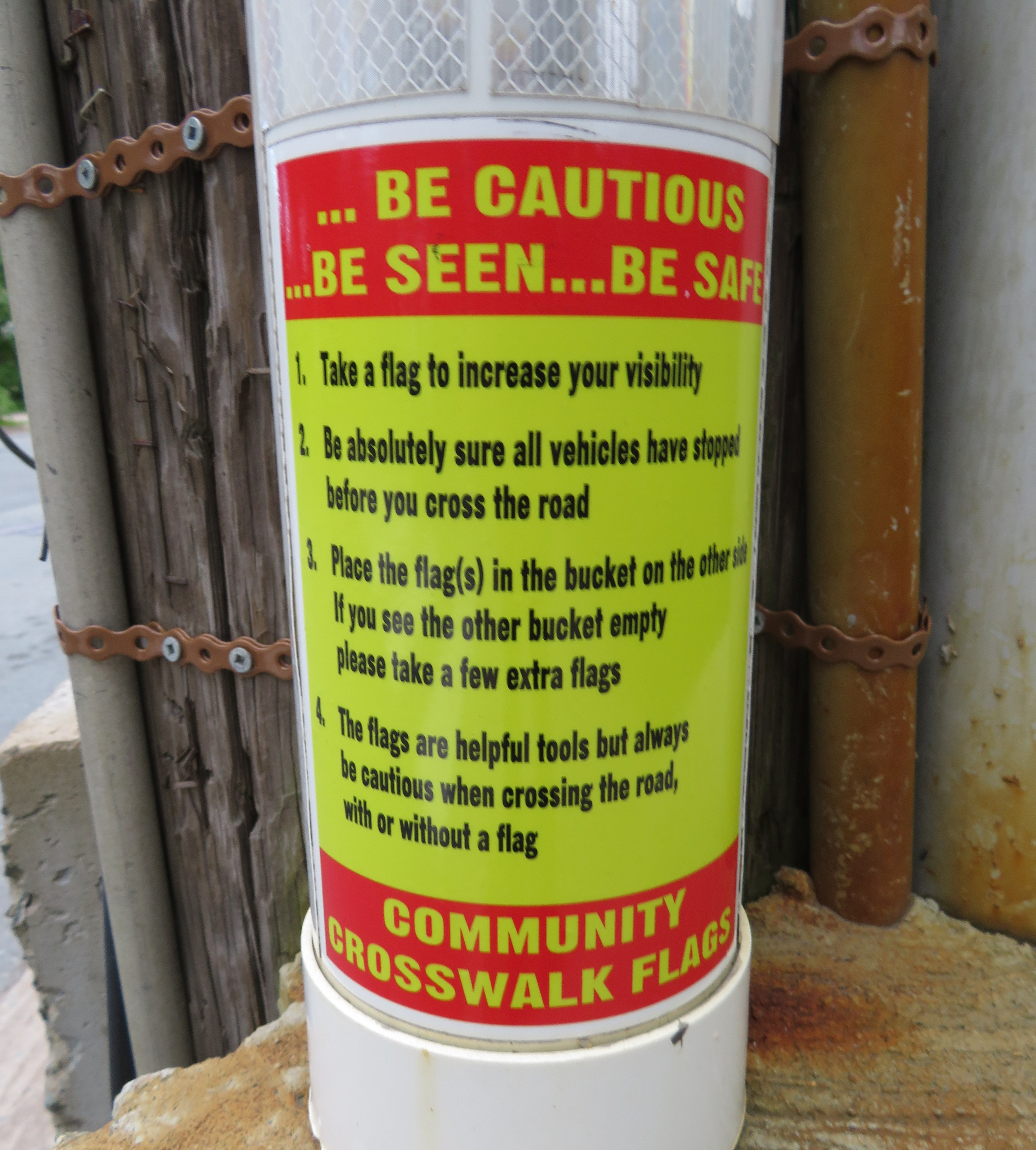
    One of the buckets, with instructions on how to use the flags left inside

    Yes, even when there are flashing lights at an intersection, Halifax Regional Council expects pedestrians to use these flags (even if city staff disagree). The instructions above clearly indicate that the onus for safety is entirely on the pedestrian crossing the street, not on motorists taking care by driving safely and attentively.

    Vision Zero is the Swedish road safety philosophy that seeks to end traffic fatalities by minimizing the effects of mistakes made my all road users. Lower speed limits, enforced by road re-engineering works (such as bump-outs, speed humps, and tighter corners at intersections) that slow down cars and trucks is one such effective measure. So are complete streets, designed to improve the safety and comfort of pedestrians and cyclists. Cheap pedestrian flags, which do not address the root problem, are not within the spirit of Vision Zero.

    If Halifax Council — or any municipal government — was serious about improving pedestrian safety, features that would help include improved lighting, narrowing the roadways at pedestrian crossings, and raising the crosswalks closer to the curb level, forcing motorists to slow down (and also improving drainage. Flags and high-visibility clothing are useful for temporary conditions and for traffic control personnel, but not for everyday conditions and everyday people. The onus should always be first on the licensed motorist to be attentive to the road and drive according to the conditions.

    A ridiculous pedestrian safety measure deserves a ridiculous walk, as I demonstrated in Dartmouth.


  • Province to look at hydrogen-powered GO trains, but it is it simply hot air?

    IMG_0268-001Electrification for GO Transit and UP Express has been proposed for years

    At GO Transit’s Willowbrook Maintenance Centre in Mimico today, the Ontario Minister of Transportation, Steven Del Duca,  announced the start of the transit project assessment process (TPAP) that will allow GO to move forward with its plans for electrification. GO RER, the $13.5-billion regional rail network plan, is dependent on a new fleet of electric trainsets to provide rapid transit across the Greater Toronto and Hamilton Area.

    But Del Duca introduced a new twist to the plot. Along with the electrification TPAP, the province will also look into the feasibility of hydrogen-powered trains. Hydrogen-powered trains are being tested in Germany by Alstom, a French rail manufacturer.

    Quoted in the Toronto Star, Del Duca said that “this is a decision that we’re making that will have to last for a generation and beyond, so we want to make sure that we’re at the leading edge of the technology.”

    The Alstom experimental train, a Cordelia LINT, is a similar model to the one used in Ottawa for the O-Train Trillium Line, a diesel light rail operation. The hydrogen-powered model has yet to be tested in revenue service; hydrogen propulsion also has yet to be tested on heavier rail equipment. The Cordelia LINTs are light rail vehicles, and under current railway regulations, cannot share the same tracks with heavier freight and passenger trains.

    My fear is that this is yet another distraction from transportation needs in the here and now. Further, I worry that the “fuel cell technology symposium” will not only distract from the GO RER project, it will give credence to NIMBYs opposing electrification – be it the construction of gantries and overhead wires, or those worried about the effects of electromagnetism.

    I have more faith in building sound, tested and true, transit systems than pursuing the newest technology there is. Electric trains have been around for over 100 years. Electric multiple unit regional rail as we know it is used in scores of cities worldwide, including Montreal, New York, and Philadelphia. Electric multiple unit trains (EMUs), which can be purchased from at least a half-dozen firms, are reliable, quick, and suitable for GO RER.

    The provincial government has an unfortunate history of promoting new technologies that end either in failure — the 1970s-era GO-ALRT plans, for example, or the promotion of Ontario-made compressed natural gas (CNG) buses to replace electric trolley buses in Toronto and Hamilton in the early 1990s. (Those buses were either scrapped early, or converted to conventional diesel propulsion.) The Scarborough RT, originally planned as the nucleus of a conventional light rail network, was replaced by a propitiatory linear induction system heavily promoted by the province.

    The idea of hydrogen-powered trains is attractive: they have zero at-source emissions; the Alstom train is train is exceptionally quiet, and only emits steam and condensed water. Electrification requires overhead gantries and wires, along with substations at regular intervals; hydrogen-powered trains require none of these expenses. What isn’t clear is whether hydrogen powered trains offer the other advantages of electric train operation, namely quick acceleration and deceleration needed for a frequent-stop regional rail service.

    I want GO RER to be built, and I want it to be built right. I just fear that the attention given to an emerging technology will be yet another distraction, especially going into an election year.

  • GO Transit’s 404 Error?

    IMG_8969-001GO Train at Gormley Station

    Previously on this blog, I wrote about how new public institutions like hospitals and university campuses are built in isolated, auto-dependent areas without regard to provincial land use policies. In St. Catharines, a new modern hospital on the city’s western outskirts replaced two urban sites, despite available opportunities that would be more accessible to at-need populations. In Orillia, Lakehead University built its campus on the edge of that small city, far from other institutions or its charming downtown core. Similar decisions are being made for new hospitals and university campuses in Niagara Falls, Windsor, and Milton.

    But Metrolinx and GO Transit, its regional transit subsidiary, often fail too to meet the provincial goals of intensification of urban centres and major transit nodes, containing urban sprawl, and promoting sustainable transportation. In Downtown Brampton, an anchor mobility hub, Metrolinx plans to build a new surface parking lot — demolishing several houses and two office buildings in the process — to satisfy commuters’ demands for free parking.

    This failure is especially evident on the newly extended Richmond Hill Line, where one new station — Gormley — opened late last year, and another — Bloomington — is now under construction. Both stations do not support any evident land use policy (both are located on the environmentally sensitive Oak Ridges Moraine); they continue GO Transit’s heritage of building stations that serve car owners, but remain largely inaccessible to pedestrians, cyclists, or local transit users.

    I recently took the train north to Gormley to inform my critique of GO Transit’s new stations. I came away even more disappointed than I had expected.

    (more…)

  • Ontario’s land use scandal: Another greenfield hospital for Niagara

    IMG_8728 (2)-001

    Recently, I discussed the greenfield locations of new hospital and post-secondary institutions in Ontario, focusing on the new St. Catharines Hospital site and the Orillia campus of Lakehead University, but also mentioning the proposed sites of a new hospital for Windsor, and an university campus in Milton. Hospitals and educational institutions are primarily funded by the province, which likes to promote sustainable development policies such as the Greenbelt, and mobility hubs at major transit nodes.

    The trouble with these new sites, located far from each city’s urban centre, is that they are difficult to reach by walking, cycling, or public transit. They don’t support downtown businesses, they ignore other potential urban land parcels (often former industrial sites), and are not in accordance with the province’s own land use policies.

    I recently returned to Niagara Region to examine Niagara Health’s plan to consolidate health services outside of St. Catharines (where it already merged two urban hospital sites to a single suburban location). It proposes consolidating most health services located in five municipalities (Niagara Falls, Welland, Port Colborne, Fort Erie, and Niagara-on-the-Lake) into one site, at the corner of Biggar and Montrose Roads, south of Niagara Falls’ urban area, but adjacent to an interchange with the Queen Elizabeth Way (QEW).

    Niagara Falls, like most of urbanized Niagara Region, is de-industrializing, with modest population growth. Employment is largely dependent on public sector jobs, such as the education and health services, and the city’s tourism industry. As a large employer, the hospital should be as accessible to its employees, as well as its patients, as possible.


    Map of current Niagara Health sites and proposed new hospital

    The proposed hospital site is at the corner of two two-lane country roads, in an area without sidewalks. To the north and west is a golf course; to the south is a Hungarian community hall, farm fields, and a few exurban ranch houses. The land was donated in 2013 by a local business family, but last fall, Niagara Falls City Council was considering purchasing an additional 20 acres for staff parking. (more…)

  • Greenfield infrastructure: not so green

    St. Catharines site, Niagara Health System

    I recently visited two Ontario cities, St. Catharines and Orillia, to illustrate the problems of building new medical and educational institutions on isolated greenfield sites.

    Large greenfield lands have several advantages: they’re easy and inexpensive to build on, they can accommodate large parking lots, and offer room for future expansion. But by the nature of their isolation, they’re more expensive to serve with road and water infrastructure, and more difficult to connect to transit. Students, patients, and employees must travel farther, and they don’t foster economic and social connections with the local community as well.

    St. Catharines

    In 2013, a new hospital campus opened in St. Catharines, replacing two smaller, run-down hospital sites just outside of the city’s downtown core. The new Niagara Health System site offers new and improved services, such as regional cancer centre, a spacious and bright dialysis unit, and a modern mental health centre. When the site opened, it was a vast improvement over the older facilities.

    But there was one, major, drawback: the new hospital site is located on the far western edge of St. Catharines’ suburban sprawl, almost inaccessible without a car.


    Location of current and former St. Catharines hospital sites

    St. Catharines Transit re-routed a bus route (Route 1) to serve the new hospital site, but it costs the transit system nearly $400,000 a year to do so. The old General Hospital had four bus routes within walking distance to its urban location. Passengers from Thorold, Merritton, or several other neighbourhoods are required to make an additional transfer at the downtown bus terminal in order to access the new site. The distance makes taxi trips more expensive for the majority of St. Catharines residents and more difficult to get to by foot or by bike.

    (more…)
  • A better Hurontario Street – an LRT update

    IMG_0091-001.JPG
    Metrolinx light rail vehicle mock-up at Gage Park, meets a Brampton Transit Zum bus, 2013. 

    Earlier this week, I visited Brampton City Hall, where at a public open house, Metrolinx and city staff provided an update of the Hurontario Light Rail Transit project. Brampton City Hall was an ironic location for the open house; before Brampton Council voted against building the LRT up to Downtown Brampton and the GO/VIA Station, the LRT line would have stopped right here. Even with Brampton’s decision, there will be three stops in the city, so an open house for local residents to provide their feedback was still needed.

    hurontario_lrt_map_en-850x550
    The Hurontario LRT project, map via Metrolinx

    The open house was quite interesting as more design details were displayed. There`s a focus on promoting active transportation — walking and cycling — and urbanizing much of the corridor. Three lanes of motor traffic will go down to two in most places, and right turning traffic will be tamed. This will make Hurontario Street a safer and more pleasant place to be.

    Along the entire LRT corridor, Hurontario Street will feature separated bike infrastructure — for the most part, there will be separated bike lanes, with multi-use paths in a few areas, especially south of the Queensway, where Hurontario Street is narrower. Sidewalks are also wider. With only a few exceptions, cyclists will be able to ride across intersections without being required to dismount. Those exceptions are at the Queen Elizabeth Way, and at Highways 403 and 407, where Ministry of Transportation Ontario (MTO) standards at interchanges will force the “stop, dismount, wait for gap” regime; pedestrians will also still have to yield to motor traffic.

    img_8334-001
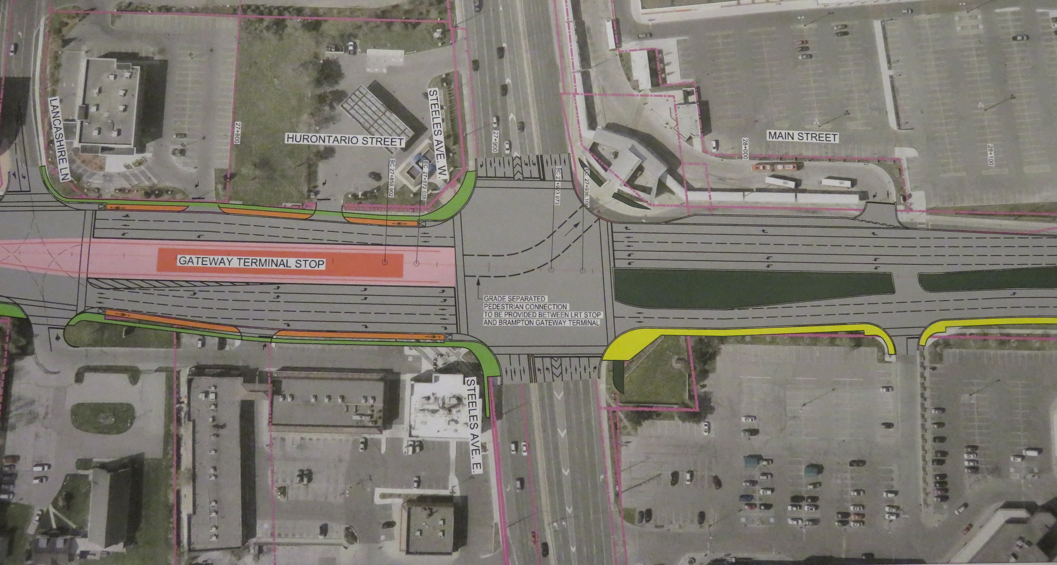
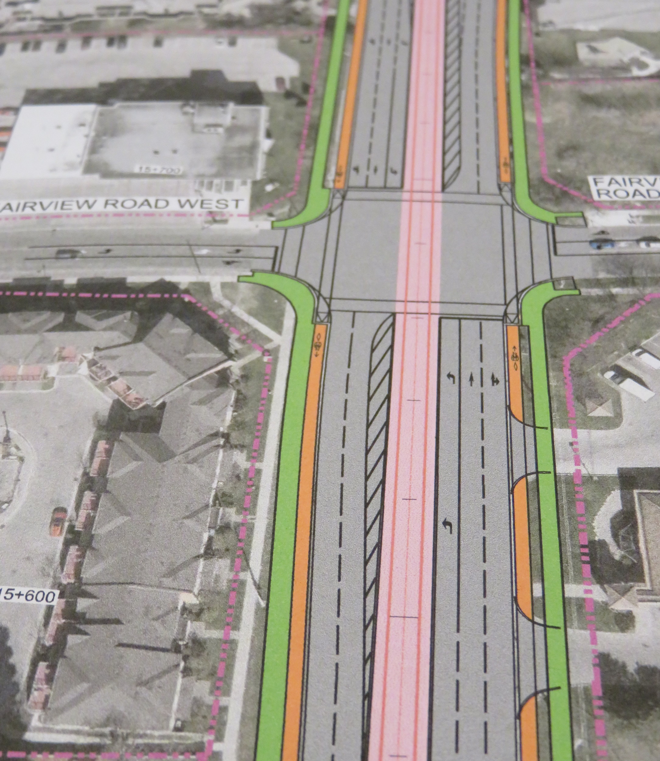
Typical cross-section once the LRT is built. The orange paths are the separated bike lanes, the green paths are sidewalks. Hurontario Street will only have two traffic lanes in each direction. 

    img_8328-001
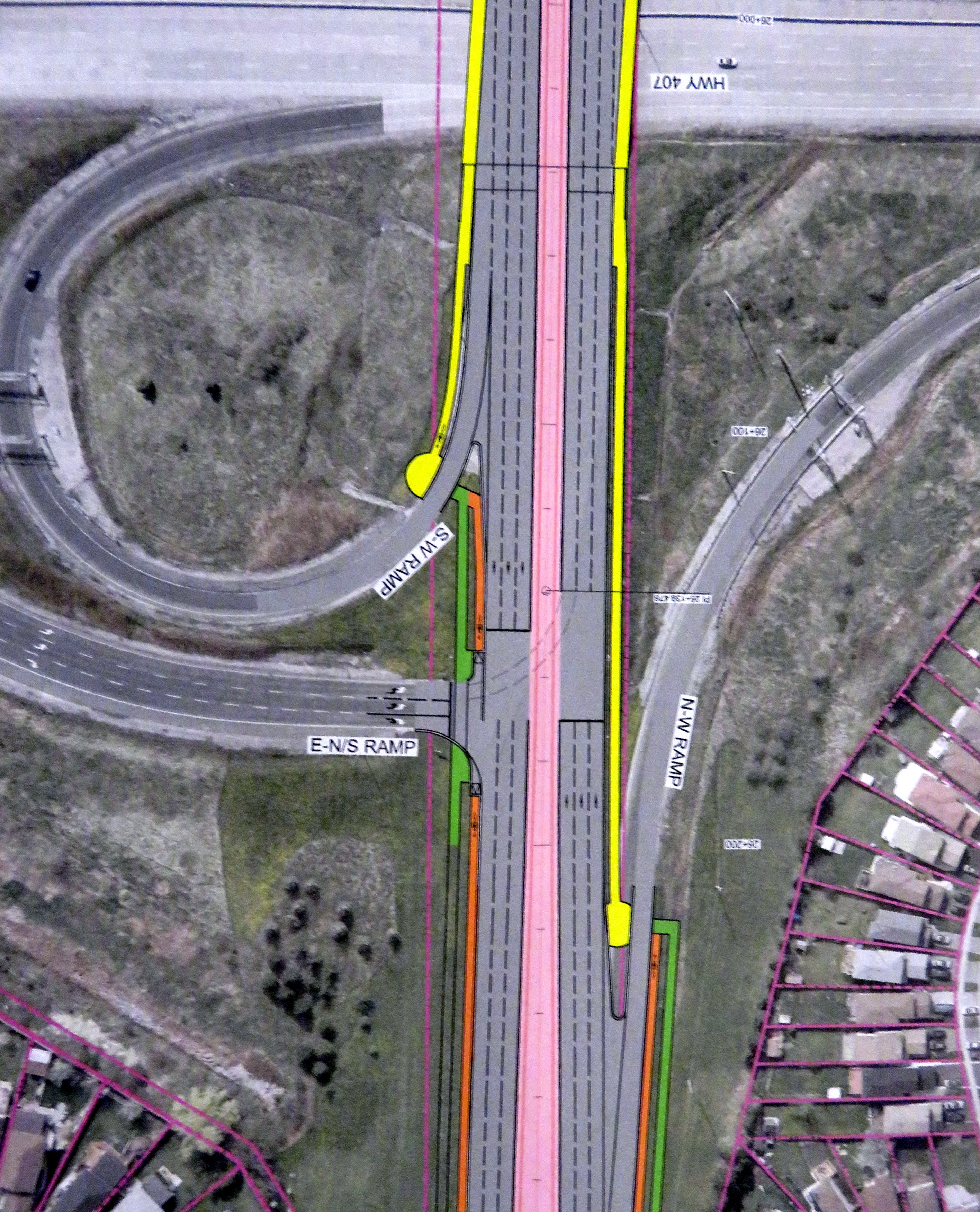
At expressways, like at Highway 407, pedestrians and cyclists still must yield to motor traffic at on-ramps. 

    In another benefit for pedestrians and cyclists, channelized right turns are eliminated along the entire route. Channelized right turns (like the one shown below) are convenient for motorists, but they increase conflicts with foot traffic and are incompatible with lower speeds and safe cycling infrastructure. Their removal also creates new room for streetscaping opportunities.

    4852433218_a9848b9973_o
    An example of a channelized right turn

    The northern terminus of the LRT, at least for now, will be at Steeles Avenue. As Brampton debates other LRT alignments (Kennedy Road and McLauglin Road are indirect alternatives to reach Downtown Brampton), the stop was moved to the south side of the intersection. This is unfortunate: the Brampton Gateway bus terminal, which opened in 2012, was designed to easily connect with the planned LRT stop on the north side of the intersection, with two short crosswalks across southbound Main Street.

    img_8331-001
    Planned LRT terminus at Steeles Avenue, including tunnel between the LRT platform and the Brampton Gateway Terminal. 

    Instead, a more expensive tunnel is required to accommodate transferring passengers between the LRT and buses. Elevators and escalators will provide direct access to the tunnel; crosswalks at Steeles Avenue and Lancashire Lane will also be accessible from the platform.

    The final contract is planned to be signed in mid-2018 and construction should begin in Fall 2018. As the City of Mississauga backs the LRT project, hopefully any change in the provincial government will not jeopardize this plan. Not only will Mississauga (and south Brampton) get a fine new transit service, it will also see a tamer, more urbanized main street.

    And maybe Brampton City Council will come to its senses and extend the transit corridor via the direct, least-expensive, Main Street alignment.