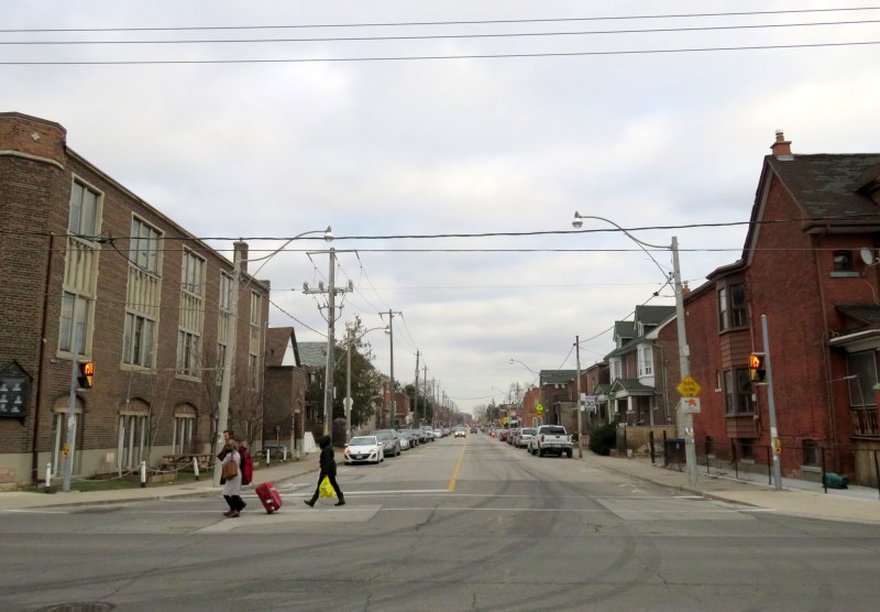
 Hallam Street looking east from Dufferin Street, January 2017
Hallam Street, which runs east-west from Shaw to Dufferin, north of Bloor Street, is unusually wide for such a quiet, short road. Hallam Street doesn’t provide a convenient thoroughfare for motorists, and nearly every storefront is either vacant, or converted to other uses. Despite being located in a dense urban area of Toronto, Hallam Street has a ghostly feeling when walking or cycling across it.
So why is Hallam Street so wide? And why does it have so many vacant or former storefronts?
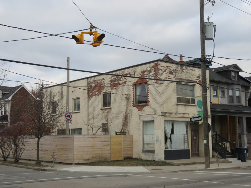
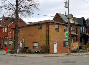
Former storefront on Hallam Street at Delaware Avenue, one of several on Hallam that were converted to residential uses
For thirty-one years, from 1916 to 1947, Hallam and Lappin Streets hosted the Harbord Streetcar, an interesting and circuitous route that served the northwest portion of the City of Toronto, and later, the east end of the city. Unlike most streetcar routes in Toronto, the Harbord Car refused to follow a grid. It wound its way through several working class neighbourhoods, tying together parts of Toronto otherwise underserved by its transit network.
The Harbord Car was re-routed from Hallam Street and Lappin Avenue to Dovercourt and Davenport Roads in 1947, as part of a re-organization of transit services in Toronto’s west end (more on that below). The streetcar was fully abandoned in 1966, when the first phase of the Bloor-Danforth Subway opened.
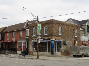
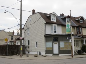
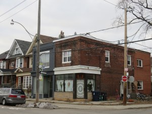
Hallam Street at Concord Avenue, where all four corners once had a store. Clockwise from top-left: south-east corner, south-west corner, north-west corner, north-east corner. Note the metal poles on the south side of Hallam installed and previously used by the TTC.
The elimination of transit on Hallam, and later Dovercourt Road, can explain some of the vacant and converted storefronts. But competition from nearby supermarkets, nearby shopping malls, along with higher rates of automobile ownership after the Second World War, likely had as much impact.
Galleria Shopping Centre, nearby at the corner of Dufferin and Dupont Streets, opened in 1972. The small enclosed mall was anchored by Towers, a discount department store chain, and a Food City supermarket, along with 40 other stores. Towers later became Zellers, and Food City was converted to Price Chopper, a discount brand (now known as FreshCo.) Galleria Mall has the type of retail that directly competes with local corner stores.
Ironically, Galleria Shopping Centre, which probably drew local shoppers away, will soon disappear to make way for a large mixed-use development. The mall is mostly leased (despite Zellers’ closure) but it has never been renovated.
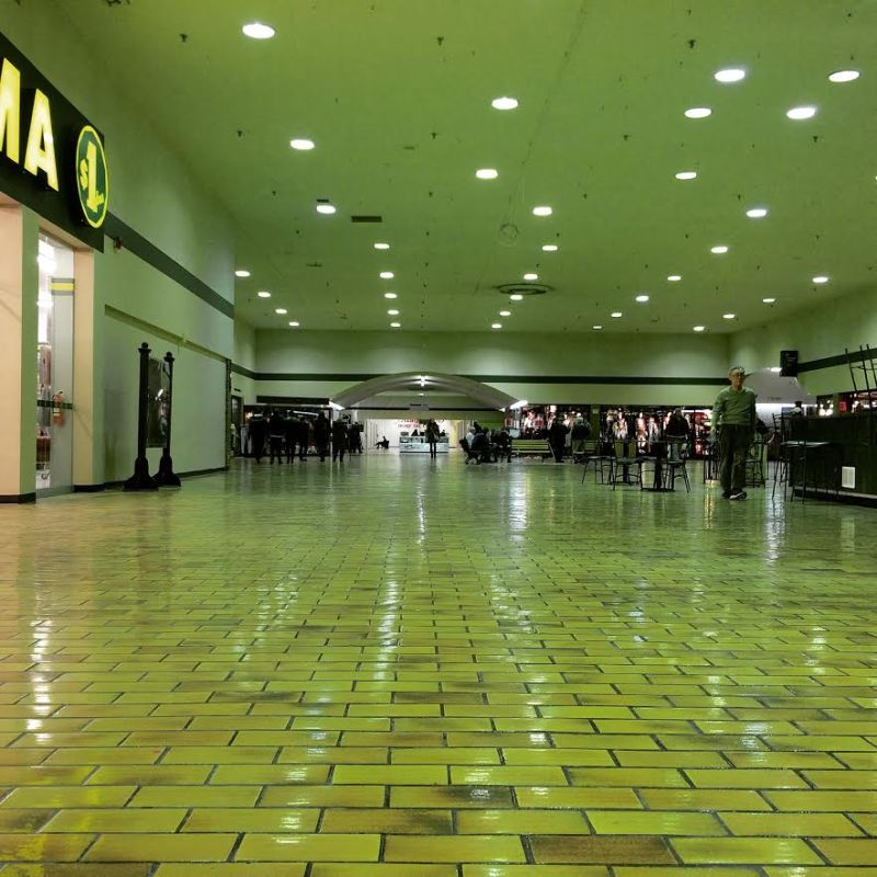 Inside Galleria Shopping Centre
A brief history of the Harbord Streetcar

1911: The Harbord Car was established by the Toronto Railway Company when new track on Harbord Street between Spadina and Ossington Avenues was put into service. Streetcars operated from Bloor and Ossington to Adelaide and Church via Spadina Avenue.
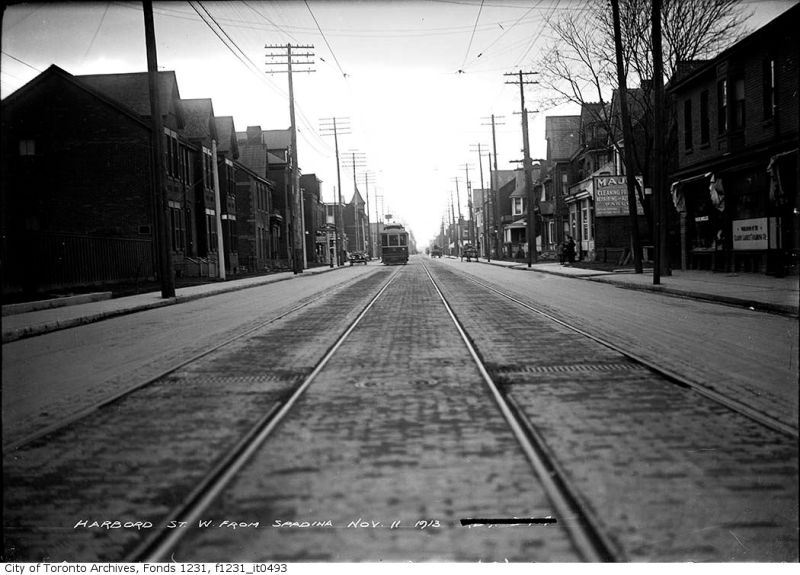
Streetcar on Harbord Street, looking west from Spadina Avenue, 1913. Toronto Archives Fonds 1231, Item 493

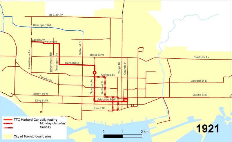
1916: The Harbord Car was extended north and west from Bloor Street via Ossington, Hallam Street and Lappin Avenue (with a short jog at Dufferin Street), with a new western terminus at Lansdowne Avenue. Downtown, streetcars looped from Adelaide via Church, Richmond, and Victoria Streets.
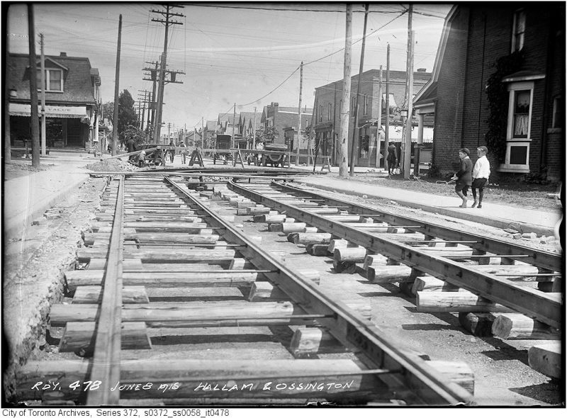
Installing track at corner of Ossington Avenue and Hallam Street, 1915. Fonds 200, Series 372, Subseries 58, Item 478
1921: The Toronto Transportation Commission took over the TRC and Toronto Civic Railways. A new Sunday service to the downtown core followed College, McCaul, and Queen Street, looping via Bay, Front, and York Streets.

1923: As part of a general rerouting of the streetcar network, the TTC re-routed the Harbord Streetcar’s Sunday route to replicate the Monday-Saturday College streetcar between McCaul Street and Danforth Avenue, via College, McCaul, Dundas, Broadview, Gerrard, Carlaw, Riverdale, Pape, and Danforth Avenue; its eastern terminus was at a loop just east of Coxwell Avenue.
The western terminus moved north on Lansdowne to a new loop at Royce Avenue. (Royce later became part of Dupont Street.)

1926: The eastern terminus of the Sunday service was cut back to a new loop on Pape Avenue at Lipton Avenue, just north of Danforth Avenue.
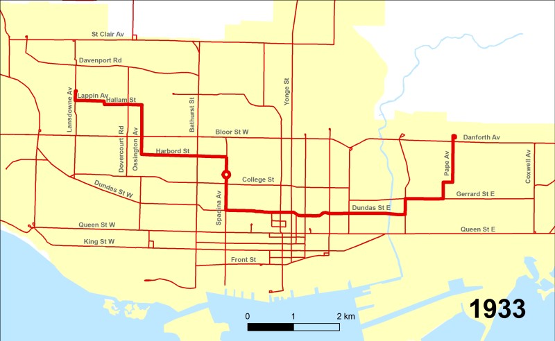
1933: The TTC cut the Monday-Saturday College Streetcar as part of service reductions due to the Depression. To replace service along the College route, the Sunday routing of the Harbord Car east on Dundas Street to Danforth and Pape became the daily route.
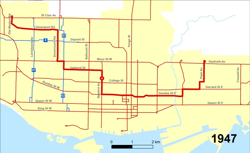
1947: As part of a general reorganization of transit services in Toronto’s west end, three new trolley buses were introduced on Lansdowne Avenue (Route 47), Ossington Avenue (Route 63), and Dupont and Annette Streets (Route 4). The Dovercourt Streetcar was abandoned, with Harbord streetcars re-routed to Dovercourt north of Bloor Street.
TTC service on Hallam Street and Lappin Avenue would never return.

1957: The railway crossing on Davenport Road west of Lansdowne Avenue was removed and replaced by an underpass, but no streetcar tracks were laid. Instead, a new streetcar loop was built at St. Clarens Avenue, just east of Lansdowne. The 41 Keele bus was extended to meet the Harbord streetcar at St. Clarens. The removal of streetcar tracks west of Lansdowne foreshadowed the carline’s demise nine years later.
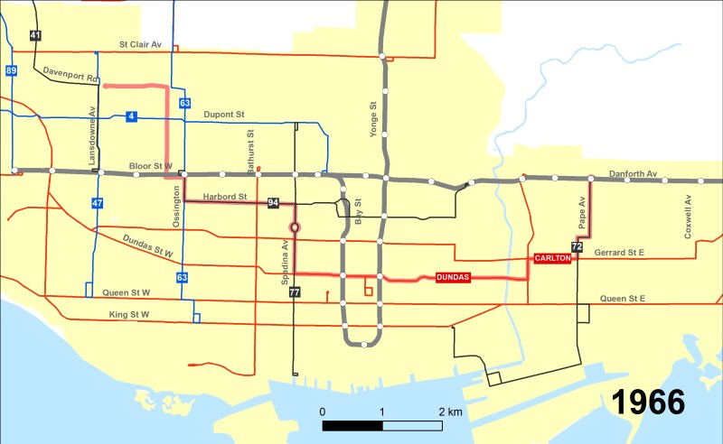
1966: The opening of the Bloor-Danforth Subway between Keele and Lansdowne resulted in the elimination of four streetcar routes, including Harbord.
The Dundas streetcar, which looped at Bay and James Streets behind Old City Hall, was extended east via Dundas and Broadview Avenue to Broadview Station, partially replacing the eastern leg of the Harbord service. The 94 Wellesley bus was extended west from Spadina along Harbord Street to Ossington Station, and the 3 Ashbridge bus was replaced by an extended 72 Pape bus to Pape Station. However, service on Davenport and Dovercourt Roads was not replaced by bus service until later.
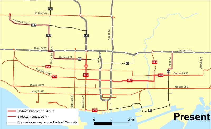
Today, the determined passenger could follow the route of the post-1947 Harbord Streetcar in its entirety, though it would require riding seven separate bus and streetcar routes, or six transfers. Transit service was restored on Davenport Road between Lansdowne Avenue and Christie Street in 1973 with the extension of the 18 Caledonia bus route, and the 127 Davenport was introduced in 1984. Public transit returned to Dovercourt Road in 1994, after the trolley bus network was abandoned and the 161 Rogers Road bus introduced.
A more detailed history of the Harbord Streetcar can be found at Transit-Toronto.

4 replies on “Hallam Street and the Harbord Streetcar”
One tiny addition: during the period when the route ended on Lansdowne north of Lappin, it turned around at Royce Loop on what is now the southeast corner of Lansdowne and Dupont (formerly Royce Street).
Thanks. I showed the change in the map, but didn’t comment on it. I added it to the description for 1923.
There were also other minor points that I intentionally glossed over for the purposes of this post, like the short period the Sunday Harbord Car served Luttrell Loop.
Great history of Hallam Street – I’d always wondered why it had corner shops and was wider than other similar streets. And the maps are great too! Thanks.
Fascinating reading. I remember the Harbord car as a kid, and it used the ‘odd’ PCCs (ostensibly bought from a US city?) similar to what the Dundas route had, I lived not far from Runnymede and Jane.
In my mid-life (about 25 years ago) I lived at Dovercourt and College, and knew there were remnants of track under the road on Dovercourt, it must have connected to the segment north of Bloor, but what I didn’t realize until seeing a TTC electrician truck parked on Dovercourt (just north of College) was that the electrical feed, for whatever reason, was still live. One wonders how much is left of the wiring above on the synonymous metal TTC poles that’s still live, long after the track is gone? (This may also apply to the now long-gone trolleys)
Oblique to any of this is this reference:
“Price Chopper, a discount brand (now known as FreshCo.) ”
I wondered why I keep slipping into old lingo calling the FreshCo at Dundas West “Price Chopper”!
Absolutely excellent article and research!