Author: Sean Marshall

  • Mapping “Team Tory”

    Back in September 2014, I created a series of maps for Matt Elliott, journalist at Metro, blogger, city council observer, and all-round great guy. Elliott’s City Council Scorecard tracked how each councillor voted on major decisions at city hall, along with a “Ford Nation” score that measured how closely each councillor voted with the mayor. Matt’s Council Scorecard was one of several inspirations for the work that I undertook so far on this blog, especially mapping the results of the 2014 municipal election.

    On April 24, Elliott published a new edition of his excellent scorecard, a check-up on how Tory has been handling council so far. I wanted to map the new scorecard and compare it to Ford’s performance. You can read more about Elliott’s methodology here.

    In 2011, newly elected Mayor Rob Ford was able to count on the support of 22 councillors — a slim majority on the 45-member council when the mayor’s vote is added. From that bloc, Ford was able to pick his executive committee, who helped push forward his agenda of cost-cutting and mucking up Toronto’s transit plans. That year, council voted with Ford over 70 percent of the time. But by December, Ford’s control was already slipping; several potential proposed service cuts were rejected, as well as Doug Ford’s ridiculous plans to take control of the Waterfront development and build a Ferris wheel and mega-mall in Toronto’s Portlands.

    Many of the city councillors opposed to Ford’s agenda  — but not all — were elected in wards representing the Old City of Toronto and East York. But six suburban councillors  — Maria Augimeri, Anthony Perruzza, John Filion, Shelley Carroll, Glenn de Baeremaeker and Raymond Cho  — were all reliable opponents. Except for Cho, who ran for the provincial Progressive Conservatives and lost in the 2014 election, the rest identified with either the Liberals or New Democrats and re-elected in 2010 despite their wards voting overwhelmingly for Rob Ford.

    Ford Nation Percentage 2011 HiRes

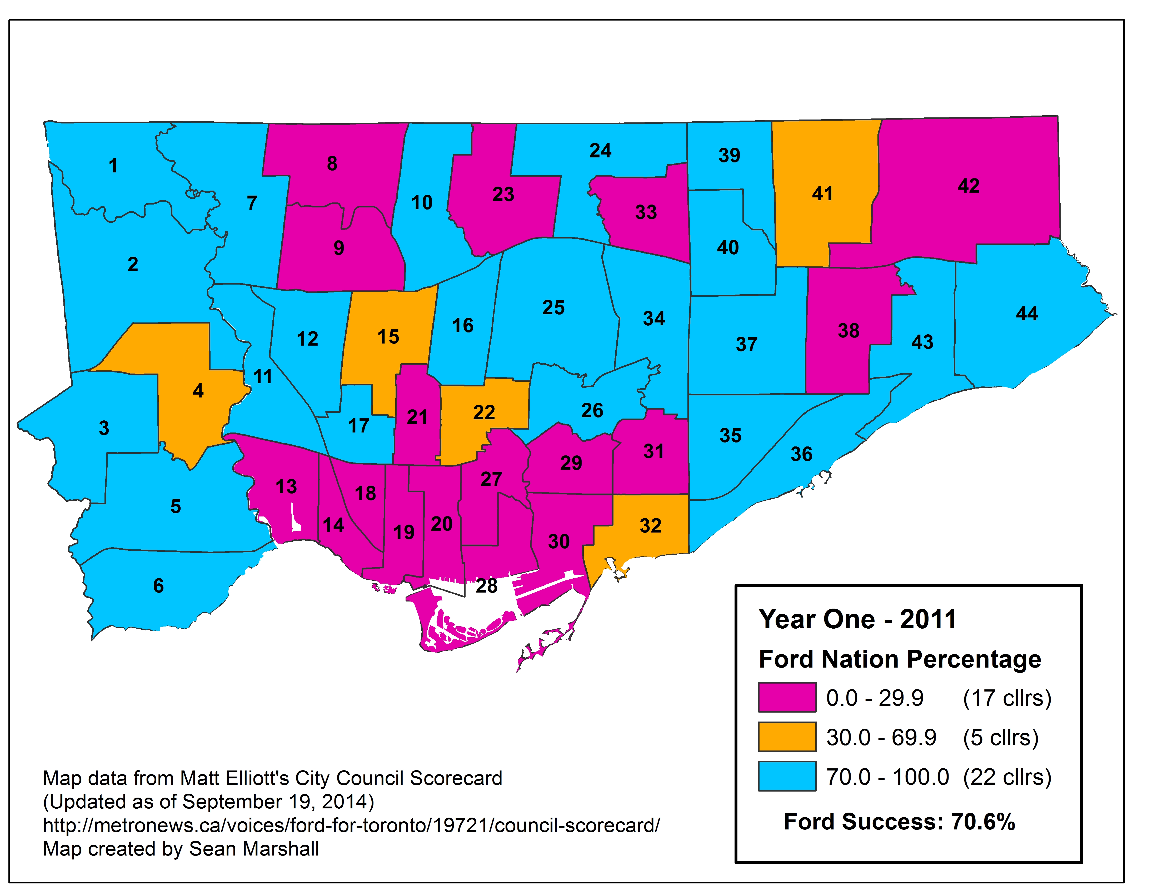
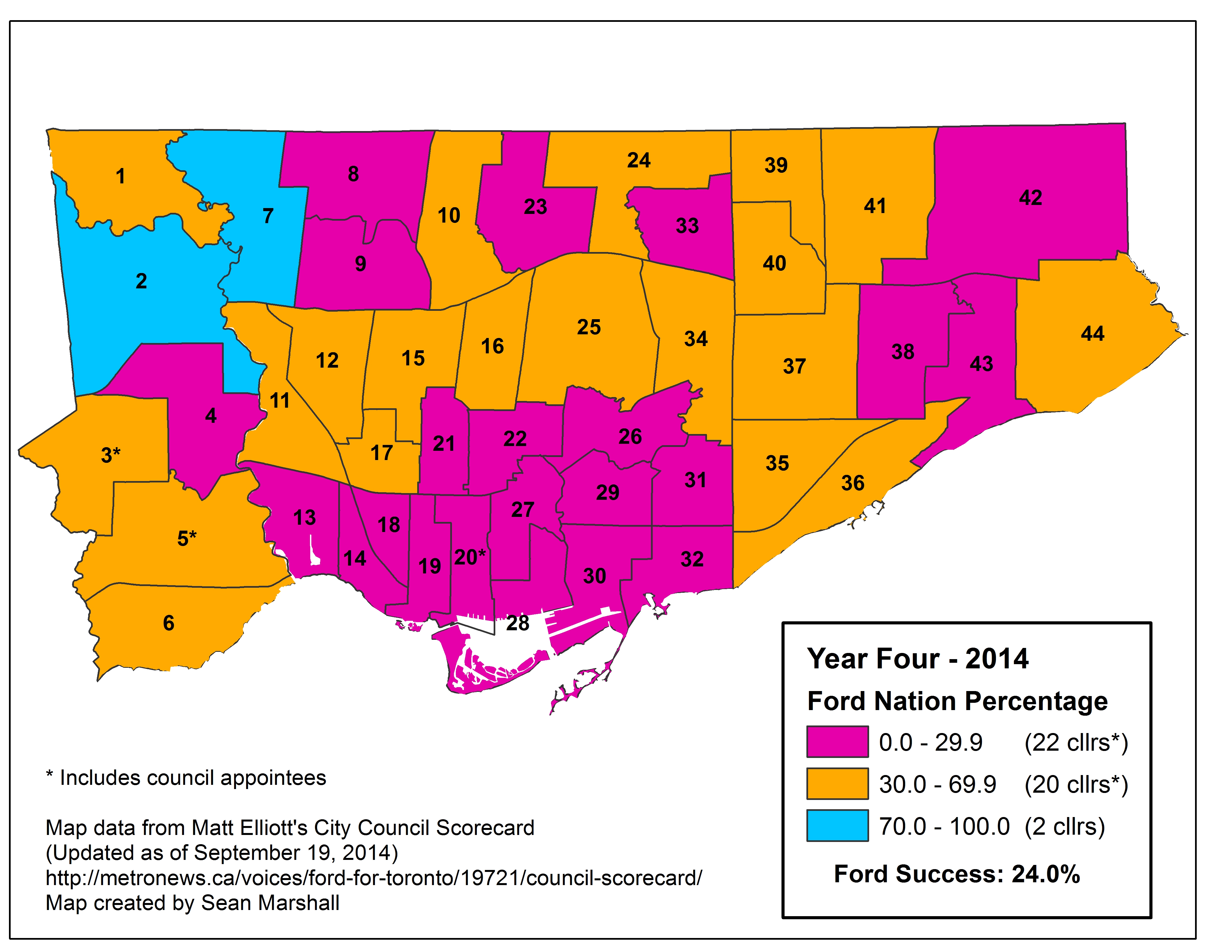
    It’s important to note that the Ford brothers’ agenda and control over council fell apart even before the Garrison Ball debacle and the crack-smoking allegations and council meltdown of 2013. In 2012, Rob Ford was only able to count on the loyal support of 17 councillors; he only had a 32 percent success rate at council that year. By 2014, Mayor Ford could only count on two reliable allies — his brother Doug, and Ward 7’s Giorgio Mammoliti; council only voted with the mayor 24 percent of the time.

    Ford Nation Percentage 2014 HiRes

    John Tory was elected in 2014 on an uninspiring, yet effective centre-right campaign, promising better governance, limited tax increases, and his own problematic transit plan. But after four years of Rob and Doug Ford, voters were looking for change. Sadly, candidates running on more substantive/progressive platforms, such as early front runner Olivia Chow and former councillor David Soknacki, either dropped out of the race or came far behind second-place Doug Ford, Rob’s obnoxious and bigoted enabler.

    Those looking for a brave new era at City Hall were disappointed by the incoming mayor’s picks for committee chairs/executive committee, speaker and TTC Chair, all plum posts that help steer the mayor’s agenda. Denzil Minnan-Wong (Ward 34), one of council’s most conservative and divisive members was named Deputy Mayor, while Rob Ford’s enabler on the council floor, Frances Nunziata (Ward 12), was re-appointed Speaker. All but two of Tory’s executive committee members were reliable Ford allies in 2011, seven of whom were on Ford’s original executive committee. (It should be said that some of those councillors, notably Paul Ainslie (Ward 43) and Jaye Robinson (Ward 25), later quit or were kicked off the Executive Committee.)

    Tory Team - April 24 2015

    Tory’s Team Score 

    Only five months into his term, John Tory had a good, but not stellar, record of getting his agenda through council. Matt Elliott found that 25 councillors have been reliable allies of Tory; voting with the mayor at least 70 percent of the time, including 5 of the 6 new councillors elected. Only six councillors — Gord Perks, Mike Layton, Joe Cressy, Kristyn Wong-Tam, Paula Fletcher, and Janet Davis, all representing “downtown” wards  — have voted with the mayor less than 30 percent on all important votes. Other anti-Ford councillors, so far, find themselves part of the “mushy middle” or “mighty middle,” though they are at this point a minority of 13. Interestingly, Councillors Rob Ford and Giorgio Mammoliti are voting with Ford most of the time so far. So much for Ford leading an “official opposition” against Tory.

    As expected, councillors that John Tory endorsed and supported in the last election  — Christin Carmichael Greb in Ward 16, Jon Burnside in Ward 26, and Mark Grimes in Ward 6 — were among Tory’s most loyal votes on council, even though none got a plum appointment (Carmichael Greb and Burnside are rookies, Grimes a three-term councillor). All three faced challenges from qualified, less conservative opponents.

    John Tory’s budget and early agenda has been less confrontational and ideological as what Ford pushed in 2011; this could be helping his score. Left-leaning councillors like Joe Mihevc (Ward 21) and Pam McConnell (Ward 28) are, for now, voting 35 percent with the mayor. The budget approved by council keeps tax increases low (I’d argue unsustainably low), but TTC cuts implemented by Rob Ford are being reversed; no services are being slashed. It’s true that council not doing enough on policing issues (especially carding/racial profiling; Tory doesn’t seem to have any interest here), nor is there enough action on the TCHC’s capital repair backlog, but so far, there haven’t been many divisive votes.

    John Tory’s budget and early agenda has been less confrontational and ideological as what Ford pushed in 2011; this could be helping his score. Left-leaning councillors like Joe Mihevc (Ward 21) and Pam McConnell (Ward 28) are, for now, voting 35 percent with the mayor. The budget approved by council keeps tax increases low (I’d argue unsustainably low), but TTC cuts implemented by Rob Ford are being reversed; few services are being slashed. It’s true that council is not doing enough on policing issues (especially carding/racial profiling; Tory doesn’t seem to have any interest in this important matter), nor is there enough action on the TCHC’s capital repair backlog. But so far, there haven’t been many divisive votes. With upcoming labour negotiations and more big-ticket budget items (the decision on what to do about the crumbling and under-capacity east Gardiner Expressway, for example), this will change.

    At times, Tory has seen to be either ignorant or dismissive of how City Council works; had he known better, there would be someone else in the Speaker’s chair, a less polarizing deputy mayor, and a few more centrist or left-leaning councillors in key positions to unite council. Mid-term, in early 2016, there’s an opportunity for Tory to revisit his committee appointments if necessary.

    It’s very possible that Tory will lose political capital as the term goes on, though it is nearly impossible to imagine him losing control of the agenda so dramatically as Ford did. In any case, it will be interesting to see if Tory learns on the job and continues to have the confidence of council, or if he starts to lose his grip as most mayors experienced later in their terms.

  • Exploring the downtown federal election races: New ridings, new candidates

    Note: On October 2, I wrote a follow-up to this post, including a few new maps, some additional insights. All three races  — Toronto Centre, University-Rosedale, and Spadina-Fort York, remain interesting and close Liberal-NDP battles. 

    As I mentioned on this blog previously, describing the “Drawing the Lines” ward boundary review now underway, there are new federal electoral district boundaries for the upcoming Fall 2015 election. Toronto will have 25 Members of Parliament (MPs) after the next election; Downtown Toronto and North York both get an additional seat and Scarborough gets half a seat (it currently shares a electoral district with Pickering).

    As a downtown resident, I wanted to explore how the new electoral map might look like in the next election, and see whether the New Democratic Party (NDP) would have a chance at picking up one of those three downtown seats, as both Toronto Centre and Trinity-Spadina are currently represented by high-profile Liberals.

    (An aside: my politics have long leaned left and towards the New Democrats; though I am not my any means a strict or loyal partisan. I have friends who are loyal Liberals,  New Democrats, and Greens; my own voting decision depends on the race – in the 2011 general election, I voted Liberal, as I lived in York Centre, a riding held by NHL Hall of Famer, lawyer and great Liberal Ken Dryden, who sadly lost to Conservative Mark Adler. I soon moved to Davenport, joking that I had traded Dryden for [newly elected NDP MP Andrew] Cash. Brampton West Liberal MP Colleen Beaumier earned my very first vote when I was 18 years old, but I have since voted NDP provincially and federally in most other elections.)

    2011 General Election

    In the 2011 general election, in which Stephen Harper’s Conservatives won a majority government (and Jack Layton led the NDP to its greatest federal victory, winning 103 seats and official opposition status), both Toronto Centre and Trinity-Spadina re-elected their popular incumbents – Olivia Chow in Toronto Centre, former Toronto city councillor and Layton’s spouse, and Bob Rae, former New Democrat and Premier of Ontario, later a Liberal MP and leadership candidate. Chow won with 54.5% of the vote in Trinity-Spadina; Rae won with 41.0% of the vote in Toronto Centre.

    As you can see in the map below, Chow placed first to most polls in in Toronto Centre, except for a few polls near the Waterfront (the Conservatives came in first in the Harbour Square condo complex), in the east Annex closest to Yorkville and a few condominium and seniors’ residences buildings elsewhere. Christine Innes, running for the Liberals, came in a distant second with 23.4% of the vote.

    In Toronto Centre, Liberal Bob Rae won with 41.0% of the vote; the NDP’s Susan Wallace took a respectable 30.2%, while Conservative Kevin Moore took 22.6% of the vote. In Toronto Centre, the Conservatives took several polls in the wealthiest parts of the riding; the “old money” Rosedale neighbourhood and several polls in Bloor-Yorkville, home of many of the most expensive condominium high-rises in Canada. The Liberals did well in polls throughout the riding (in Rosedale, Yorkville, Cabbagetown and St. Lawrence), while the NDP came in first most polls in Church-Wellesley, St. Jamestown, Moss Park, and Regent Park.

    2011 Fed Election - Downtown (1)Results by poll in the 2011 federal election in Trinty-Spadina and Toronto Centre

    (more…)

  • The beauty of the expressway and Toronto’s accidental gateway

    IMG_8568-001Highway 427 looking south from Burnhamthorpe Road

    On a recent walk with a group of friends and acquaintances, I had the opportunity to explore a bit of Etobicoke. We walked from Kipling Station to a pub near the West Mall and Burnhamthorpe Road, passing by an abandoned dead mall, cutting through another mall, Cloverdale, with its sad, emptying Target that was just a few weeks before closing (along with the rest of Target’s ill-fated Canadian stores).

    Honeydale was built in the early 1970s, a rather small mall anchored by a Woolco and a grocery store. The grocery store became a No Frills, while Woolco was acquired by Wal-Mart in 1994. Most Woolco stores were converted to Wal-Marts, but the US-based giant soon expanded or built replacement stores to its own specifications, leaving behind many vacancies in older malls and plazas. With the loss of Wal-Mart, the mall survived only because the only entrance to the busy No Frills store was within the mall. Once No Frills closed, Honeydale lost its purpose and shut down. Like the Canadian Tire property down the street (the oddly named Kip District development), I expect that the mall, Toronto’s only bona-fide dead mall, will soon be razed and that condos will eventually take its place.

    Unlike Honeydale, Cloverdale, a somewhat larger mall that boasts few vacancies, will most likely survive Target’s retreat from Canada.

    Honeydale Mall
    The vacant Honeydale Mall

    But the most interesting takeaway, in my opinion, is reflected in a photograph I took on the Burnhamthorpe Road bridge over Highway 427, the first photo in this post.

    There is a complicated beauty to freeways; corridors that we usually experience either at speeds of over 100 kilometres an hour, or stuck behind other cars and trucks in frustrating traffic jams. But from a perch over top, such as on an overpass, one can appreciate the landscape. And see the gateway to Toronto, guarded by tall towers on either side.

    Sheraz Khan wrote about this “accidental city gate” in Spacing Toronto in November 2013. He wrote that “…the road to Toronto tells a story about our city. Through the concrete, the wires, the bricks and tangled roads, gleams our new gate. It is a structure that begins to (perhaps accidentally) emphasize Toronto’s wishes of grandeur.”

    Coming from the airport down Highway 427, arriving in Toronto for the first (or the 500th) time, by car or by bus, one can experience this unplanned, and apt, entry to the city. A city of concrete, glass and steel, a city that is continually growing to accommodate its many newcomers. A city as defined by its suburbs as its downtown.

  • Mapping Toronto’s Rental Complaints

    MLS - Draft 2

    Over at Torontoist, I took a look the City of Toronto’s data on complaints made to Municipal Licensing and Standards (ML&S) on multi-residential apartment buildings. All properties with at least 25 notices or orders that are either open, or issued and closed within the last two years are mapped; the ten properties with the highest number of offenses are highlighted and listed.

    Many ML&S investigations are the results of neighbours’ complaints of improper waste disposal, graffiti, long grass, unkempt grounds, or fence disputes; these complaints are distributed all over the city. These are usually quickly solved, resulting in only one or a handful of orders issued. However, troubled buildings might have dozens, even hundreds of violations, ranging from poor groundskeeping, to poor interior lighting, to more cringe-worthy deficiencies such as failures to guard against pest infestations, leaking pipes, damaged and stained ceilings and walls, and unsanitary waste collection and storage. Failure to comply with enforcement officers’ orders can result in prosecution.

    Most of the properties that I mapped are found in the inner suburbs, or in the Church-Wellesley, St. Jamestown, Midtown and Parkdale neighbourhoods of the old City of Toronto, where many older rental towers are located. A disproportionate number of problematic residential properties can be found in Neighbourhood Improvement Areas (previously known as priority neighbourhoods) —25 of the 40 properties with at least 100 ML&S notices or orders are in NIAs. Of the 10 worst buildings, five are large, private rental buildings, the other five are owned by the Toronto Community Housing Corporation.

    You can search the ML&S database by address for yourself here. It’s not a bad resource if you’re in the rental market and looking at perspective apartments.

  • Why Toronto needs new ward boundaries

    The City of Toronto is in the process of reviewing the ward boundaries. This is an overlooked and much needed initiative. Due to population increases in central Toronto, North York and in Scarborough, parts of the city are unrepresented at City Hall. Some councillors are overworked with development proposals in their wards, while other parts of the city are relatively quiet.

    While some will argue for fewer politicians (the idea has a populist appeal), I would like to see more city councillors, elected by ranked ballot (which Mayor John Tory supports), to best serve the needs of our diverse and dynamic city. Based upon the population from 2011 census, Wards 20, 23, 27, and 42 are the most underrepresented at City Hall; Ward 42 includes the new Morningside Heights neightbourhood, while condominium construction have swollen the number of residents in Wards 20, 23 and 27. Simply put, the boundaries have to be changed to provide more equal representation. Ward representation 2011 census Map of how each ward is under-represented or over-represented in Toronto, map based on one previously created by Christopher Livett

    The city’s review process, which you can find more about here, is being conducted by independent consultants, so far free of political influence. Though the first round of public consultations have already occurred, there will be further opportunity to participate in the development of ward boundary options. There has yet to be a decision as to how many councillors Toronto should have going forward, or what the boundaries will look like. The committee will report to city council in early-mid 2016 with their recommendations, giving plenty of time before the next election, which will be held in October, 2018.

    (more…)

  • Mapping an accessible TTC

    IMG_3898

    Last week in Torontoist
    , I wrote about the challenges of getting around on the TTC for passengers who rely on mobility devices, such as wheelchairs. Most of us never think about this problem unless we’re directly affected by the consequences of an inadequate system, as I was after a cycling injury in 2012.

    But for TTC users with mobility disabilities (or even passengers with strollers, wheeled carts, or luggage), it’s an issue. While the bus system is (mostly) fully-accessible, the backlog in the delivery of new streetcars and the installation of elevators in subway stations leaves the system failing many of its riders. The alternative, Wheel-Trans, is also underfunded, inconvenient and useless for last-minute travel plans.

    Here’s what the subway system looks like if you require the use of elevators to navigate the system:

    accessible map - now 2015

    By 2016, only one more station  — St. Clair West  — will be equipped, by 2017, Wilson, Ossington, Coxwell, and Woodbine (and hopefully the Spadina Subway Extension to Vaughan Centre, with its six new fully-accessible stations, will open by then) will follow. But there’s not enough funding to make the entire system accessible by 2025, the deadline set by the Accessibility for Ontarians with Disabilities Act (AODA). Seventeen stations, including Islington and Warden, remain unfunded.

    The entire bus fleet is accessible, though not all bus stops are (the TTC requires a solid, concrete or asphalt place to deploy the ramp or lift, and room for the passenger to board; some suburban stops without a bus pad, or narrow urban sidewalks make loading a passenger in a wheelchair difficult). The first four low-floor streetcars are operating on Spadina Avenue, 200 more are still to be delivered. By now, the Spadina, Bathurst and Harbourfront cars were to have been fully-equipped with the new trams.

    In the meantime, the few bus routes that operate in the central core don’t have many accessible connections; east-west travel is particularly difficult. For example, the 47 Lansdowne bus is inaccessible from either subway station it services (Lansdowne and Yorkdale), and offers no barrier-free transfers south of Dupont Street. The map below shows this problem:

    TTC - Downtown v3 Crop

    Elevators at Ossington would connect the subway with three accessible bus routes, including the 94 Wellesley, a useful east-west alternative. (The 94 serves four subway stations and enters three of them, not one is equipped with elevators.) Meanwhile, both Toronto Western and St. Joseph’s Hospitals are isolated from the accessible transit network.

  • Mapping the City’s Bike Network Gaps

    Bike-Routes-WO-GapsToronto’s Bikeway Network, as of January, 2015

    Over at Torontoist, I posted a short article about the gaps in Toronto’s cycling infrastructure. You can read it here. What follows is a quick summary and some more thoughts (and another map, showing the bikeway network without the sharrows and signed routes without bike infrastructure).

    Toronto’s bikeway network is composed of multi-use paths (off road trails in parks and ravines, shared with pedestrians), cycle tracks (separated bike lanes like those on Sherbourne), bike lanes and contra-flow bike lanes (painted bike lanes without separation; I don’t consider the flex-posts on Adelaide, Richmond and Wellesley to be proper separations — see this Metro Toronto article about a garbage truck entering the bike lane and destroying these flimsy plastic markers). The city also considers other signed bike routes (usually quiet residential and collector streets without heavy traffic) and sharrows to be part of its bikeway network, but I don’t.

    Bike Routes - WO Gaps, sharrowsToronto’s Bikeway Network, as of January, 2015, with the sharrows and signed routes removed
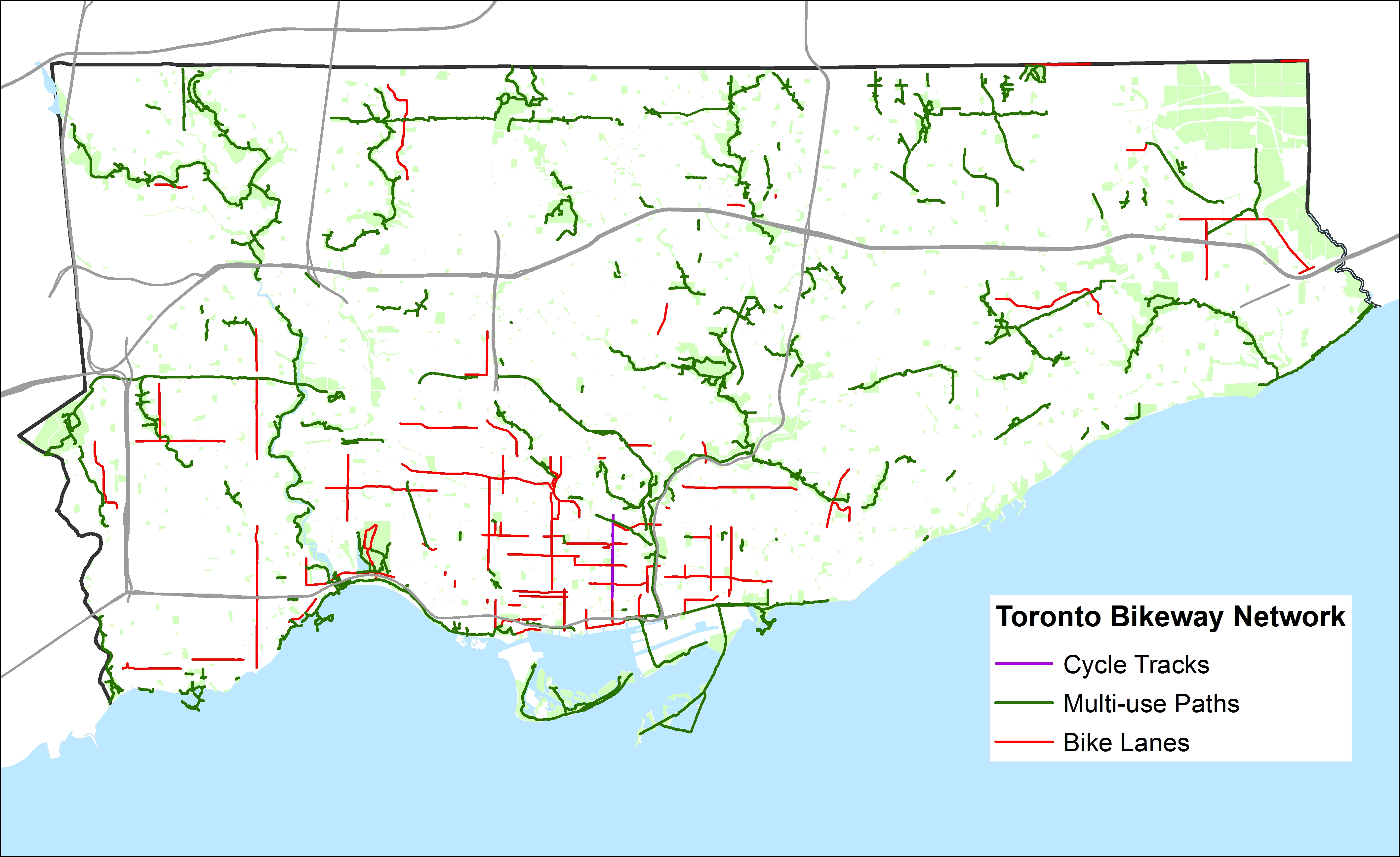
    When the sharrows and signed routes are eliminated, Toronto’s bikeway network looks very thin, especially outside the downtown core. Furthermore, most multi-use trails (shown in green) are not cleared in the winter (the Martin Goodman Trail the only exception) and many are unlit; they are not the safest options for women or vulnerable users.

    Below, I show some of the gaps in the existing network; where bike lanes and multi-use trails should be connected to create at least a complete network of bike-friendly routes across the city. Several circle routes are slowly coming together (via the Humber, Don, Rouge, Highland Creek and east-west hydro corridors) but there are many gaps that need to be closed to complete these circuits. The Waterfront trail is a disconnected labyrinth in Scarborough; I’d like to see a new multi-use trail beneath the beautiful Scarborough Bluffs to connect the trail to the parks below otherwise isolated and inaccessible without a car.

    The gaps in the existing bikeway network show the shortcomings in cycling infrastructure to support a minimum grid of safe bike routes in the suburbs, which would be mostly built on city streets, not in ravines or hydro corridors. Note that there are only three designated places to cross Highway 401, which is a much greater barrier to more Torontonians than the Gardiner Expressway is downtown.

    For his part, during the 2014 campaign John Tory said that he would support bike lanes where it was “sensible.” But he did not define what that meant or provide a timeline for specific goals. Given the number of bike-unfriendly councillors returned to city hall; one of whom is now John Tory’s deputy mayor, I don’t have too much confidence in seeing much more than a few downtown projects and more multi-use trails constructed in the next four years.

    Bike-Routes-Gaps
    Some of the many gaps in the existing bikeway network

  • The genesis of Mayor John Tory’s SmartTrack

    I was recently browsing Urban Toronto‘s forums (a great resource if you’re interested in keeping up with construction updates and development proposals here in Toronto), when I came across a post written by “AlvinofDiaspar” in a thread discussing SmartTrack.

    Alvin’s post linked to an interesting report written by the Strategic Regional Research Alliance, a consulting group based in Toronto that I had never heard of until recently. The report, entitled “The Strategic Case for the Regional Relief Line,” was published in October 2013, just before the mayoral race began for the 2014 election.

    John Tory unveiled his “SmartTrack” plan, promising a “London-Style surface rail subway” (whatever that meant), on May 26, 2014. The transit service, using frequent, electric multiple unit trains (like those used for commuter/regional transport in many European cities) would mostly follow existing railway corridors from Markham to Mississauga, via Union Station.

    On the east end, the route would follow GO Transit’s Stouffville Line from Union Station as far as Unionville Station, making more frequent stops, serving the Unilever plant (which will be replaced by a massive commercial/office redevelopment by First Gulf, first announced in 2012), as well as additional stops at Queen St East, Gerrard/Carlaw, Lawrence East, Ellesmere, Finch and 14th Avenue, in addition to existing GO Transit stops at Danforth/Main, Scarborough Junction, Kennedy/Eglinton, Agincourt (Sheppard), Milliken (Steeles) and Unionville.

    To the west, the line would follow GO’s Kitchener Line from Union Station as far as Mount Dennis (Eglinton Avenue, near the western terminus of phase one of the Eglinton-Crosstown LRT), with stops at Spadina, Liberty Village, the existing GO/UP Express station at Bloor, and at St. Clair Avenue. At Mount Dennis, the SmartTrack corridor follows a routing via Eglinton Avenue into Mississauga’s Airport Corporate Centre office district, which of course has no existing rail infrastructure to capitalize on.

    Tory promised to have SmartTrack operational in seven years, by 2021, putting other approved and/or proposed transit projects (the Downtown Relief Line, the Sheppard East and Finch West LRTs, among other plans) on the back burner.

    smarttrack_fbJohn Tory’s “SmartTrack” map

    Back in 2014, transit observers were taken aback by this new “bold” transit idea (John Tory kept using that word to describe SmartTrack), as his campaign had recently taunted Olivia Chow’s hesitancy to prioritize the Downtown Relief Line (DRL) in her transit platform. At the time, Chow, the presumed front runner in the mayoral race in April 2014, promised to increase TTC bus service and build the Scarborough LRT while planning for the DRL continued.

    The DRL is a long-proposed subway line under review by the City of Toronto and by Metrolinx that would connect downtown Toronto to the Bloor-Danforth Line east of the Don River, thus relieving the the Bloor-Yonge subway interchange from overcrowding, while offering improved transit access to east end Toronto, and addressing overcrowding on Yonge subway trains. Further extensions to the north, towards Thorncliffe Park, Flemingdon Park and Don Mills, would re-direct many current and potential transit riders from the Yonge Subway, allowing for an extension of that line from Finch to Richmond Hill.

    But to some degree, Tory’s promise of frequent, regional electric rail on GO’s corridors dovetailed with provincial plans for electrification of part of GO’s services and the Airport Rail Line (now branded as the Union Pearson Express). Improved services on GO’s corridors, if paired with fare integration with local transit (GO’s fares are very expensive for short trips), would provide useful rapid transit to many areas not served by the subway, and could provide some relief to the existing subway network. John Tory was endorsed by many provincial cabinet ministers; it appeared that he had the support of the Liberal government itself, though Premier Kathleen Wynne never endorsed any mayoral candidate directly.

    The only hint of this SRRA report that I could find in the mainstream media was in an interesting article written by Tess Kalinowski, the transportation reporter at the Toronto Star after Tory’s win on October 27, 2014. In an article published on November 17, entitled “The evolution of SmartTrack,” a report entitled “The Business Case for the Regional Relief Line” was mentioned. Also mentioned in the article was John Duffy, a political strategist who worked on the provincial Liberal leadership campaign of former transportation minister (now environmental minister) Glen Murray, and had ties to Wynne’s leadership and election campaigns. Kalinowski wrote that Duffy also was acquainted with Iain Dobson, a property developer and Metrolinx board member. Other people involved in putting SmartTrack together and mentioned in the article were the Canadian Urban Institute’s Glenn Miller (who is listed as a SRRA contact on its website, as is Iain Dobson, a real estate executive and Metrolinx board member), former Toronto chief planner Paul Bedford and businesswoman and urban expert Anne Golden.

    Transit advocate and friend Steve Munro picked up on this report before I had – you can read his posts which are more detailed and far better than my short analysis in this post:

    Munro: The Dubious Planning Behind SmartTrack Part I Part II Part III

    It’s unfortunate that John Tory decided to make this concept the centrepiece of his transit platform. Easily, the biggest flaw, mentioned by others, including Steve Munro and mayoral rival Olivia Chow, is the Eglinton section between Mount Dennis and the Airport Corporate Centre. The corridor already had a proposed rail transit project, the western leg of the Eglinton-Crosstown LRT line, a project first proposed in 2007 as part of a larger city-wide LRT plan known as Transit City, and confirmed in 2009 when the provincial government announced funding for it and three other LRT lines. (In 2010, funding was deferred for the section west of Weston Road). The once-available right-of-way that would have allowed for a surface-running heavy rail transit project was already disappearing.

    But in the SRRA-authored report, we see why Tory went along with the problematic Eglinton routing, rather than having SmartTrack continuing along the GO Kitchener/UP Express corridor towards the transit desert of northwest Toronto. It was part of a larger plan to connect suburban office parks to Downtown Toronto.

    The Regional Relief Line, as envisioned by the SRRA, would have included a third phase, from the Airport Corporate Centre to Meadowvale Business Park, another large, although sprawling, employment centre near Highway 401 and Mississauga Road. The “Phase Three” of this proposed regional rail route would follow Highway 401 on a new alignment.

    srra mapThe map from the SRRA report, published on page 4. Note the use of Google Maps to create the map.

    The SRRA planning exercise appears to be one where well-educated planning experts were engaged in a game of “connect the dots.” Sure, the Regional Relief Line connected several major employment nodes in Markham, Toronto, and Mississauga, with the nodes in Mississauga lined up along Highway 401. But this error on page 6 of the report makes me wonder how many of the facts and assumptions the authors simply got wrong or didn’t fact-check:

    This phase will take a little longer to complete than the Markham phase because there are no tracks on the section from Mt Denis to the Airport Corporate Centre. This right of way will take longer to design and obtain approval in an EA process. It is owned by the Province and was intended to be an expressway. There is ample room for the dedicated right of way.

    In fact, the Richview Corridor, the right of way mentioned, was owned by the city, not the province, reserved in the 1960s for an expressway linking Highways 401 and 427 to the proposed Highway 400 extension, part of a much larger highway plan for Metropolitan Toronto. The 400 extension was cancelled and the at-grade Black Creek Drive was built instead; the Richview lands along Eglinton Avenue West in Etobicoke remained dormant for decades. But in 2011, the city started selling off the land for residential development, making the right of way unusable for any transportation corridor. (This did not matter in plans for the Eglinton-Crosstown LRT connection to the airport; there was still room to build a median LRT corridor along this section.) In 2013, pre-eminent local transit and planning experts should have been aware of this development and be able to identify the proper owner of this former right of way.

    It also strikes me as a little backwards looking to link auto-dependent office parks together with a new transit line, especially without a detailed origin-destination study. Shouldn’t urban planners be promoting dense urban employment clusters in areas well-served or potentially well-served by transit? Does it make sense to build expensive transit lines to serve low-density office complexes that come with large parking lots and garages, such as those in Mississauga’s Airport Corporate Centre? Or am I confused?

    In December 2014, mere weeks after Tory’s election, Council voted 42-1 to accelerate the work plan for the rail line, awarding up to $750,000 for early analysis and modelling work. The consultants awarded the funds? A group from the University of Toronto and Strategic Regional Research Associates. In February, council approved an additional $1.65-million towards studying SmartTrack, at least taking a closer look at the Eglinton West section of the corridor.

    To me, it seems just a little bit odd that Tory’s campaign advisers were awarded this contract to study a project, that until Tory’s election, wasn’t even on any transit planning maps. Steve Munro picked up on this as well, questioning whether  Iain Dobson, a member of the Metrolinx Board, has a conflict of interest due to his involvement with the SRRA and a member of the Advisory Board to the University of Toronto Transportation Research Institute. After all, Metrolinx is supposed to be the expert, disinterested provincial agency charged with evaluating and implementing various transit plans. Meanwhile, the need for a Downtown Relief Line hasn’t gone away.

    Tory and his connections in academia and the private sector have managed to change the course of Toronto’s short-term transit planning, and I can’t help but feel a bit suspicious of the behind-the-scenes planning that went into SmartTrack. This is a story very much worth following.

  • Streetcars of desire: why are American cities obsessed with building trams?

    IMG_5868-001

    Back in January, I posted my thoughts on some of the new streetcar systems being built in the United States after visiting Detroit, Cincinnati, Atlanta and Tampa on a Florida road trip. I soon cross-posted the article to Spacing, where it got more interest.

    Not long after the Spacing cross-post was published, I got a message from Guardian Cities. The editor, Mike Herd, asked me if I was interested in writing a similar piece, expanding on my post and discussing the difference between the streetcars in my hometown of Toronto, and the new systems being built in the US.

    It was an interesting experience, and one where I came to appreciate the role that content editors have. The article went through several major changes until we were all happy with the final product.

    You can read my Guardian Cities article, which was published on Friday, here:

    Streetcars of desire: why are American cities obsessed with building trams?

  • Mapping the 2014 Toronto Election: Wards 43 and 44

    Last, but not least, in my series of posts examining the results of the  Toronto municipal election of October 2014, are Wards 43 and 44, Scarborough East.

    I started these series of maps of the 2014 Toronto election as a few tweets. To me, it was a simple, interesting exercise. At first, I only sought to map the most interesting wards, where there were competitive races for city council – wards where the incumbent wasn’t running again, or where great candidates like Alejandra Bravo, Russ Ford, Lekan Olawoye, Dan Fox, and Andray Domise, were taking on established councillors and offering a better alternative to local voters. After requests to have a place to have these maps available somewhere, I resolved to set up a blog and to map every poll. It has taken me a bit longer than I expected, but I hope that these maps become useful between now and the 2018 election.

    While my politics certainly lean left, and my commentary on my blog at times pointed, all the maps I created are available to everyone. Despite my cynicism, I genuinely believe most people run for public office for the right reasons. Putting your name on the ballot takes courage; making a serious run for any elected office, even school trustee, is a long, difficult, exhausting, and expensive undertaking. I respect nearly every candidate who make that effort, regardless of their political leanings.

    And now, with the ward maps done, I’ve thought of more ideas to pursue in the near future. I’m interested in voter turnout; with esteemed Ryerson Professor Myer Siemiatycki, I co-wrote a study commissioned by the Maytree Foundation studying voter turnout in previous municipal elections. With poll-level data, it would be most interesting to look at voter turnout by housing type (such as TCHC vs. private rentals vs. condominium residences, for example) and other local determinants.


    Ward 43

    Ward 43 is represented by Paul Ainslie, a centre-right leaning councillor who I’ve come to respect. Ainslie was picked Chair of the Government Management Committee (and a member of Mayor Rob Ford’s executive committee) after the 2010 election.

    But unlike most Scarborough politicians, Ainslie parted with Ford on many issues. In 2011, Ainslie voted 97% of the time with Ford; but by 2013, he only voted 40.5% of the time with Ford. In 2014, Ainslie’s “Ford Nation” score (as developed by Metro columnist Matt Elliot) was only 20%, a difference of 77%. This was the greatest drop in Elliot’s “Ford Nation Percentage”score. In a CBC article dated October 15, 2013, Ainslie started to “butt heads” with Ford early that year “over budget issues.”

    That October, after the first Ford crack scandal hit but before Rob Ford’s November meltdown that ended up seeing Norm Kelly assume most of Ford’s responsibilities, Ainslie resigned from Ford’s executive. Ainslie supported the Scarborough LRT replacement project (which would include an extension to Progress Road and Sheppard Avenue) instead of the Bloor-Danforth Subway extension. For his actions, Rob Ford then recorded a “robocall” message to Ward 43 residents that read:

    “It was extremely, extremely unfortunate that your councillor, Paul Ainslie, was the only Scarborough councillor who did not listen to his constituents, and voted against the Scarborough subway. In fact, he led the charge against building subways in Scarborough; unfortunately it has led to his resignation from my executive committee. We are moving forward with a team who support the mandate Toronto taxpayers gave me…”

    The calls were made from Ford’s own City Hall telephone number. Eventually, Mayor Ford was forced to apologize on the council floor in 2014, in one of many rulings the City’s integrity commissioner made against the mayor. Despite Ford’s outrageous claims, Ainslie regularly engages with his constituents, including discussing the subway/LRT issue.

    Ainslie’s position on the Scarborough Subway/LRT dovetailed with the transit platform of mayoral candidate David Soknacki, who represented Ward 43 before Paul Ainslie was elected in 2006. Ainslie got his start at city hall as Councillor Soknacki’s executive assistant. (In February 2006, Ainslie was appointed to council to represent neighbouring Ward 41, filling in for former councillor Bas Balkisoon, who was elected as a Liberal MPP in a provincial by-election. Ainslie’s run for Ward 43 councillor later that year was controversial, as appointed councillors are typically expected not to run in the next general election.)

    As in neighbouring Scarborough Ward 36, most polls on the Lake Ontario shoreline in Ward 43 voted for John Tory. Conversely, all but one poll north of the GO Lakeshore East Line, a City of Toronto long term care home near Scarborough Centenary Hospital, voted for Doug Ford. Ford came in first place in Ward 43, netting 45.7% of the vote, while Tory came in second place with 35.3%. Olivia Chow only took 15.5% of the vote.

    Paul Ainslie handily won re-election in 2014 (despite Rob Ford’s robocalls) with 74.3% of the vote. Second place candidate Mark Harris had the vote of only 10.5% of the electorate.

    2014 Election - WARD 43 Mayor
    Poll results of the mayoral race in Ward 43

    Ward 44

    2014 Election - WARD 44 Mayor

    Poll results of the mayoral race in Ward 44

    East of Highland Creek, the residential areas between Kingston Road/Highway 401 and the lake mostly voted for Tory, continuing Tory’s pattern of coming in first in middle and upper-income polls in Scarborough that straddle Lake Ontario. West of Highland Creek; Polls 027, 028 and 029, while also bordering Lake Ontario, are for all intents and purposes inland; the GO Lakeshore East line (CN Kingston Subdivision) separates residential areas to the north with the parks, factories and municipal facilities (water treatment plants). These polls, which supported Doug Ford by wide margins, are located in the West Hill Neighbourhood Improvement Area (the new nomenclature for what used to be called “priority neighbourhoods); Poll 027 includes the Danzig Street TCHC community where one of Toronto’s worst mass shootings occurred on Monday, July 16, 2012. Most polls north of Kingston Road also voted for Doug Ford.

    Ford came in first place in Ward 44, taking 44.1% of the vote to Tory’s 38.6%. Chow only got 14.9%. As in Ward 43, Tory won the advance poll by a comfortable margin despite coming in second place in both wards.

    Ward 44 also had one of the closest council races as three viable candidates sought to unseat 71-year old Ron Moeser, who left everyone guessing whether he’d run for council again despite a poor attendance record attributed to health concerns. Moeser has long been a dead weight on council, quite possibly its least active member. Moeser was first elected to Scarborough council in 1988, he has been a city councillor since then, except betweeen 2003 and 2006, when Gay Cowbourne defeated him; she did not run again in 2006 and Moeser took back the seat.

    In the 2010 election, Moeser narrowly won in Ward 44, taking 47.4% of the vote to second-place Diana Hall’s 46.1%, a difference of 284 votes.

    In 2014, the Toronto Star endorsed Hall, Cowbourne’s former executive assistant, describing her as a “thoughtful conservative” while NOW Magazine halfheartedly endorsed Amarjeet Shhabra, explaining that the main reason to vote for her was to defeat Moeser. Shhabra, a union organizer, had the Labour Council’s endorsement.

    It’s too bad the Toronto Star and NOW overlooked Moeser’s strongest challenger.

    Moeser unfortunately won in a crowded field of 15 candidates; several of whom had name recognition and organized campaigns. But Moeser won just 25.7% of the vote in the 2014 election, 3769 fewer votes than in 2010. But was Jennifer McKelvie, an environmental scientist and adjunct professor at Ryerson University, who came closest to defeating Moeser, taking 23.4% of the vote, a difference of 572 votes. Hall came in third with 22.2%, and Chhabra came in fourth, netting 11.4% of the vote. McKelvie came in first in 14 election day polls as well as the advance poll, Moeser won in 16 polls, Hall in 5. Most polls that supported Doug Ford the strongest stuck with Moeser for council, while polls where Tory came in mostly voted for Hall or McKelvie, the remainder might have voted for Moeser, but by very small margins.

    Had there been a less crowded field, I suspect that Moeser would not have won in 2014.

    (Interestingly, the advance polls reflected the election day results, there would be two more women on Toronto City Council; Alejandra Bravo also won the advance poll in Ward 17, but couldn’t dislodge Cesar Palacio.)

    McKelvie, who was running for public office for the first time, has some impressive credentials; had she won, she’d be great fresh voice at City Hall. But in several wards, including 3, 5, and 26, the second-place candidate in the 2010 election went on to prevail in 2014. This should be welcome news for Jennifer McKelvie, who I hope will be interesting in running again.

    2014 Election - WARD 44 Cllr