Category: Toronto

  • Welcome to Toronto, we guess

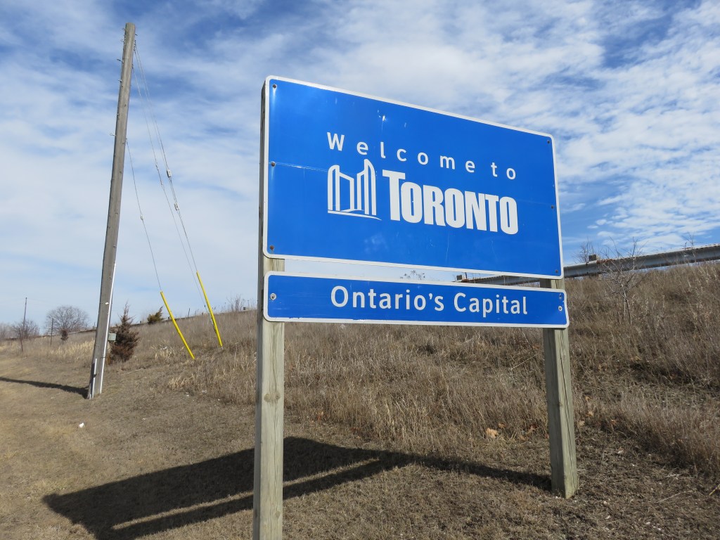
    Welcome sign when entering the City of Toronto

    Last weekend, I was out exploring the Toronto-Mississauga border. I have a few thoughts about suburban transit projects like the Mississauga Transitway and as I have time, I’ll post those here.

    But where Eglinton Avenue crosses Etobicoke Creek, motorists (and the few brave cyclists and pedestrians), are greeted with a sign that said, simply, “Welcome to TORONTO” and underneath, “Ontario’s Capital.”

    Yes, Toronto is the capital of Ontario; that’s what they teach childen in Grade 2, along with the other provincial and territorial capitals of Canada. But surely, a city of three million people that’s known for its talent, creativity, and diversity can come up with something better than this uninspired sign, which is found at many, if not most, entrance points to the city. The welcome sign would even better off without the “Ontario’s Capital” tab.

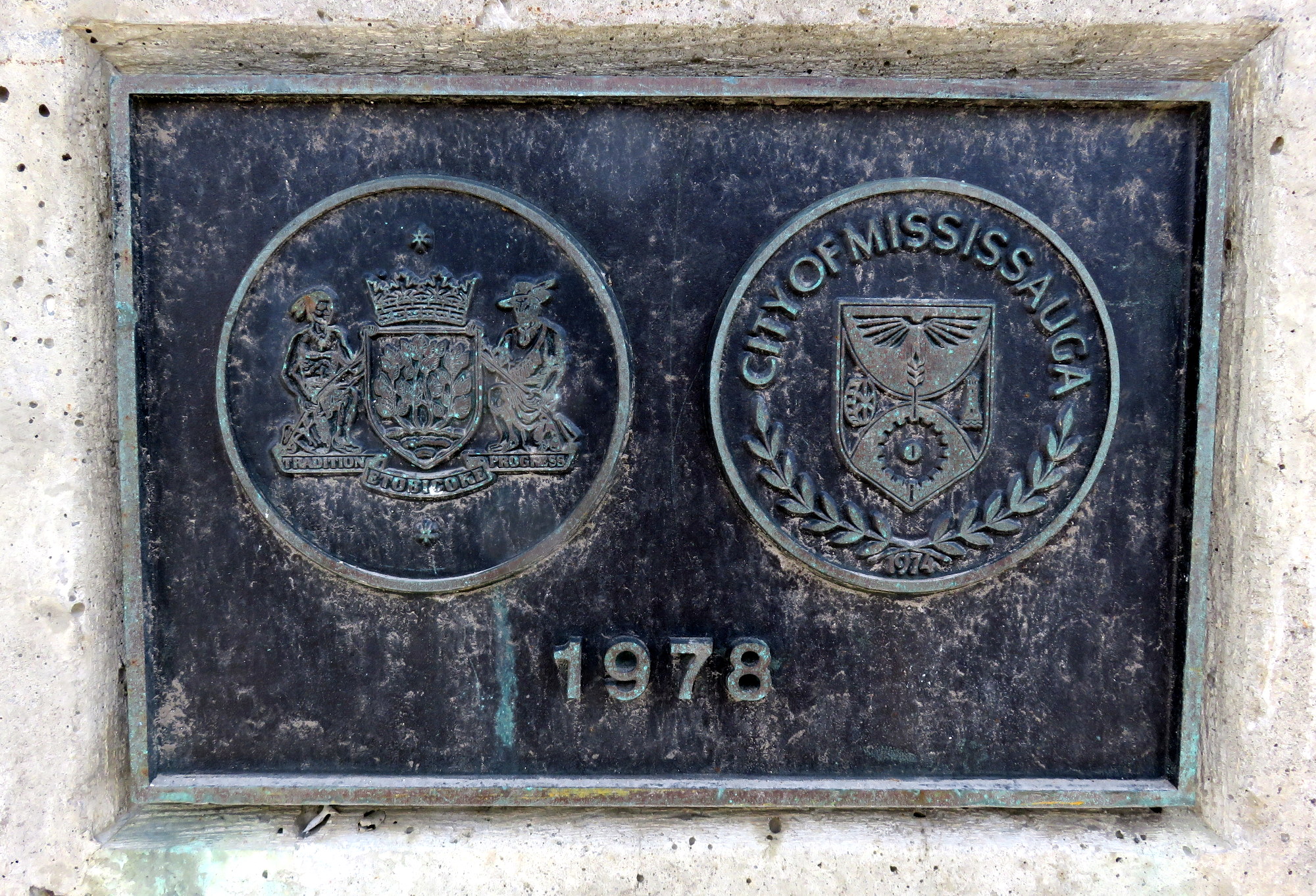
    But while I was walking on the Etobicoke Creek bridge — a hostile environment as any for a humble pedestrian — I noticed this plaque, marking the border between the City of Mississauga and what was then the City of Etobicoke. The bridge was built in 1978, but is being widened to support a new bus rapid transit project. This section of Eglinton is built for cars, but it is only as a pedestrian that you can spot this sort of detail.

    IMG_0312-001

    In 1978, Etobicoke’s motto was simply “Tradition and Progress” while Mississauga’s crest didn’t sport a motto. Today, signs welcoming you to Mississauga say “Leading today for tomorrow, a rather boastful, yet meaningless slogan.

  • The upshot of the new, lower UP Express fares

    24281427544_ddb67d604d_k

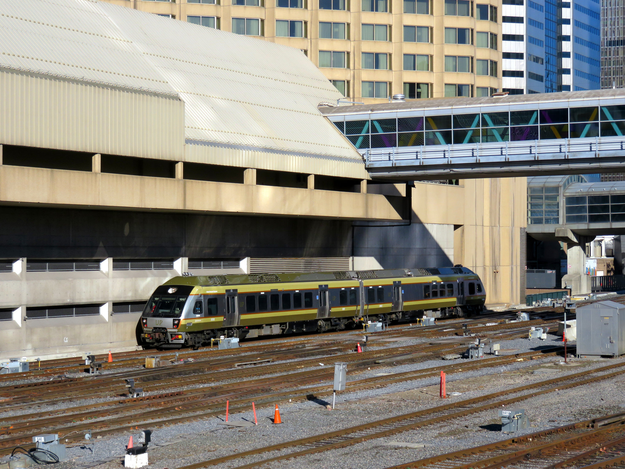
    Earlier this month, I commented on the poor ridership numbers of UP Express, Metrolinx’s airport rail link between Toronto’s Pearson International Airport and Union Station. I suggested that despite the embarrassing ridership figures, UP Express (UPX) was no white elephant. I argued that instead, the rail service could be a useful transit link for residents of North Etobicoke, Weston, Mount Dennis, and West Toronto.

    Later today, Metrolinx’s Board of Directors is expected to approve a major fare reduction for UPX slashing fares by over 50 percent. The Globe and Mail broke the story yesterday; today the Toronto Star has more details.

    The one-way cash fare between Union Station and Pearson Airport will drop from $27.50 to $12.00; the fare charged to Presto cards will drop from $19.00 to $9.00. Fares between Union Station, Bloor and Weston will drop to the equivalent GO fares. (The 2016 GO Transit fare from Bloor to Union Station is $5.30, or $4.71 with Presto; from Weston, it is $5.65, or $5.02 with Presto).

    The UPX fare between Union Station and Pearson will still be priced at a premium compared to the equivalent GO Transit fare — the cash fare from Union to Malton Station is $7.70, or $6.84 with a Presto card.

    Interestingly, before UPX was launched, Metrolinx conducted studies on potential ridership and fares. One study, by Steer Davies Gleave, that some UPX trains might even at capacity by August. You can read Metrolinx’s market research and ridership studies (with some details redacted) here. Obviously, there weren’t enough well-heeled business travellers willing to ride UPX for $27 each, or even enough local residents willing to pay $19 with their Presto card.

    This change in pricing makes UPX much more attractive for commuters in the Junction/Junction Triangle neighbourhood, as well as those living in Weston. The lower fares should help increase ridership between Pearson Airport and Union Station as well. It’s a good start, but it isn’t enough.

    Last year, I commented on GO Transit’s “fare by distance” structure, which charges disproportionately high fares for short distances, and very inexpensive fares for long commutes.  While GO offers co-fares to suburban transit agencies, it offers no such fare integration with the TTC. GO Transit offers free parking at suburban rail stations, burying the cost of building and maintaining its parking lots into the fares of every passenger, whether they need parking or not.

    The charts below show the single ride and Presto fares, per distance travelled in 2016, with the new UPX fares. Per distance travelled, a GO Transit fare to Union Station to Exhibition, Bloor, and Danforth is more expensive than going from Toronto to Pearson Airport via UP Express.
    2016CashFares 2016PrestoFares

    Metrolinx is in the midst of developing a new fare integration strategy, so hopefully these concerns will be addressed. Once the TTC completely rolls out Presto at all subway stations and on all buses, it will be technically simple to adopt a GO-TTC co-fare, and UPX should be part of this as well. There are tens of thousands of jobs at the airport and in the surrounding offices and industrial parks. With proper fare integration with TTC, Miway and Brampton Transit (all of which serve Terminal 1), UPX could become much more useful to many more commuters.

    Lowering UP Express fares is a good start, a welcome acknowledgement that the rosy forecasts of business travellers crowding the airport trains were never reached. But lowering fares isn’t enough: with proper fare integration, UP Express can offer far more utility than simply being an airport rail link.

  • A new, improved TTC system map

    Last week, the Toronto Transit Commission quietly introduced a new system map on its website. The map, a 3.8 MB PDF file, can be directly accessed here.

    This new system map, which includes all scheduled routes including the limited-service community buses and the Blue Night network, is very different than previous editions of the TTC’s “Ride Guide,” but I think it is the best edition yet. That said, there are a few tweaks that I would like to see.

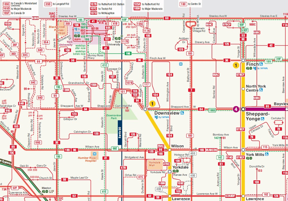
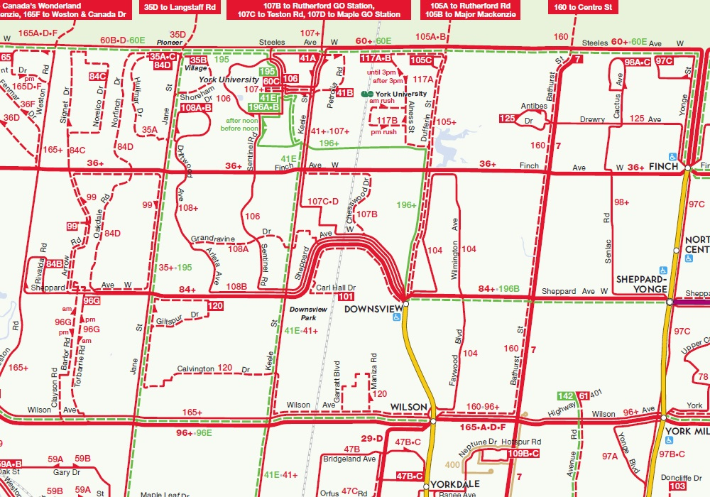
    Below is a screenshot of the new 2016 map, showing York University, Downsview Station, and North York Centre.

    TTCJan2016

    Unlike previous editions, the new Ride Guide is not to scale; subtle curves and bends in the road network are dispensed with in favour of a diagrammatic style, which shows transfer points very well. (It reminds me of the Los Angeles Metro system map.) Like the 2012 edition, shown below, only the streets served by surface routes are illustrated, but landmarks (such as hospitals, post-secondary education institutions, and major parks) are given more prominence than in previous maps. GO Transit rail lines are more prominent (with the same colours used on GO Transit maps and schedules), and there’s an effort to show connections with other transit systems, such as GO buses, and suburban agencies such as York Region Transit, Miway, and Brampton Transit.

    TTCAug2014
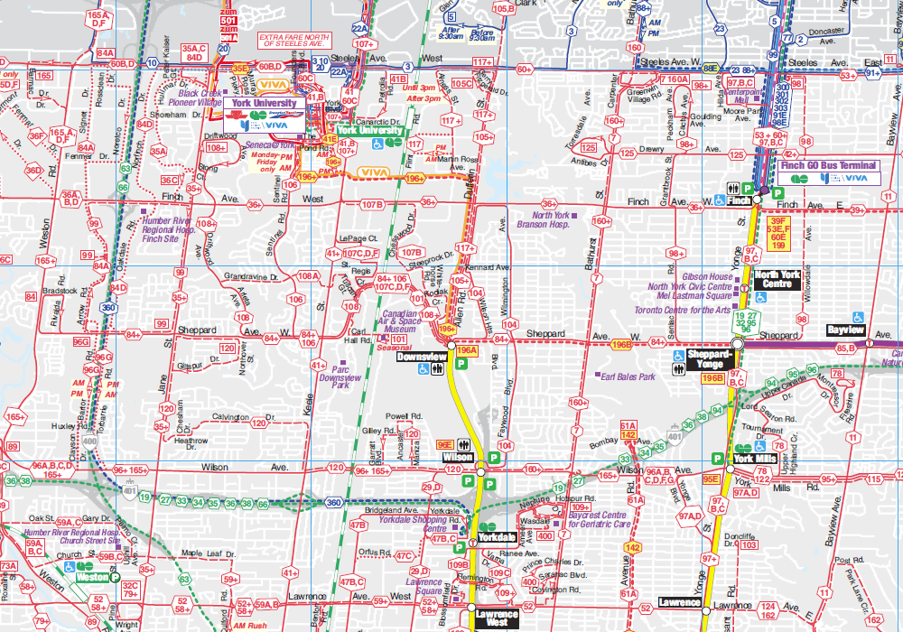
    Screenshot of the 2014-2015 edition of the TTC Ride Guide, showing the same area as the 2016 map.

    From 1994 to 2012, the TTC’s official system map included the routes of adjoining transit systems (see screenshot below). Note the YRT, GO Transit and Brampton Transit Züm routes converging on a very crowded York University. Depicting the connecting networks was certainly useful, but it added to a very cluttered map (which included the entire street network); it also relied on every other agency to provide timely updates. Removing the other transit agencies’ bus routes in 2014 allowed the TTC design team and cartographers to concentrate on their own system.

    In 2014, the system map was stripped of almost all features apart from the TTC’s own routes, a decision I criticized in a previous post. All landmarks were removed, as were all connections, apart from faint lines showing GO Transit rail corridors. It was easier to read, but went too far in removing important and use information. But it had a few improvements, such as highlighting the “frequent service network” – surface routes that operated every ten minutes or better at most times of the day. Express bus routes were better depicted.

    The 2016 edition restores these features lost in 2014. In a few places, the logos of the suburban transit agencies are once again shown, such as York University (where Brampton Transit, GO Transit and York Region Transit connect) and Pearson Airport (where Brampton, Miway and GO also operate). The contact information for the five neighboring systems is also included on the map. The addition of the frequent service category remains.

    TTCNov2012November 2012 Ride Guide

    Overall, I think the new map looks great. Surface routes are clearer, GO Transit rail lines are more prominent, and more points of interest are shown. Not only does downtown Toronto get a new inset, so does a complex section in north Scarborough, where the 102 Markham Road, the 53 Steeles East, and the 42A Cummer routes converge. The TTC design team has done a fine job.

    But I did find a few things about the new 2016 edition that I would like to see improved:

    • Hospitals are labelled inconsistently. Humber River, Sunnybrook, and Scarborough Centenary are, but North York General, Etobicoke General, Scarborough General, St. Joseph’s, East Toronto General, and the downtown hospitals are not.
    • Some suburban connections are shown, most are not. Pearson Airport shows GO, Brampton, and Miway logos, and York U shows GO, Zum, and YRT logos, but they are missing from Humber College, a major terminal for Brampton Transit (511, 11, 50) and Miway (22, 107), it’s a terminus for a YRT route as well. Rouge Hill GO shows a DRT logo, even though this is a very limited service, but there isn’t one for Miway at Long Branch, where two major routes, 5 and 23, terminate.
    • I’m not sure I like how branches are labeled now; I miss the use of the “+” that denoted a section of a route on which all branches operated on.

    Hopefully, we will see these relatively minor issues corrected in the next edition of the Ride Guide, which will likely be issued later in 2016.


    If you’re interested in the history of TTC maps, Transit Toronto has a fine archive of old system and subway maps dating back to the 1930s. It’s worth a look.

  • Armed with facts, the Toronto Relief Line Alliance is launched

    TRLA-Map-01-1

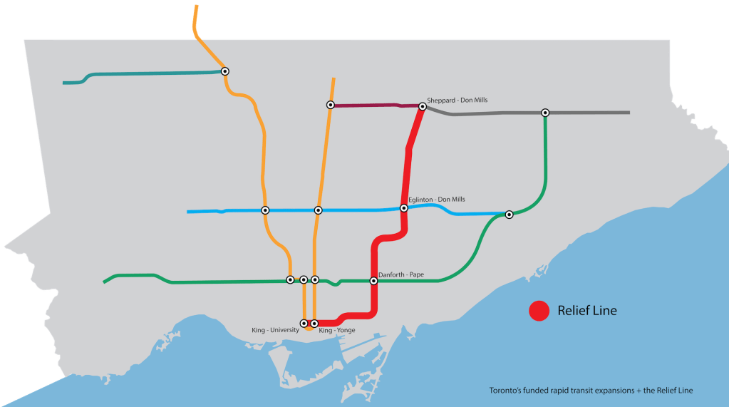
    The Relief Line is a subway route intended to reduce crowding and congestion in Toronto’s existing subway system. Planned for over a century, we may finally see work started in a few years. If Toronto finally puts shovels in the ground on this vital transit project, we will have a new grassroots advocacy group, armed with facts, to thank for that.

    Even though a relief subway line is very old idea, one that goes back over 100 years, the only construction ever done were roughed-in streetcar subway platforms at Queen Station built in the 1950s. A Queen Street subway remained on the TTC’s books until approximately 1980, when attention was focused on building subways in Toronto’s growing suburbs. But a Downtown Relief Line (DRL) was included as part of Network 2011, a plan drafted in 1985. If implemented, Toronto would have also seen new subways below Eglinton and Sheppard Avenues. Changes in the provincial government, opposition from downtown and suburban councillors and declining TTC ridership saw only two sections of subway opened: Downsview Station in 1996, as well as a shortened Sheppard subway, completed in 2002.

    With increasing TTC ridership, the continued employment growth in Downtown Toronto, and no new road capacity, we are again faced with the need for downtown transit relief. During rush hour, commuters often have to wait for two or three trains to pass before boarding. Bloor-Yonge Station is operating beyond its design capacity. While there may be some short-to-medium term opportunities for transit relief with the revised plans for SmartTrack, GO RER, and other capacity improvements, such as Automatic Train Control on Line 1, the Relief Line will need to be built soon.

    Planners and advocates of the DRL have wisely dropped “Downtown” from the name of the proposed subway. Thanks to populists like the Fords, and opinions such as University of Toronto Professor Margaret Kohn’s, “Downtown” has become a dirty word. There’s a false, and frankly dangerous, opinion that wealthy downtown residents benefit from subway projects, while the needs of suburban residents are brushed aside by an “openly contemptuous” “downtown cognoscenti.” In reality, the Relief Line will benefit suburban commuters the most, especially if it continues north of Danforth Avenue along the Don Mills Corridor, serving low-income, high-density neighourhoods such as Thorncliffe Park and Flemingdon Park.

    As Metrolinx and City Planning redraw plans for SmartTrack, the Scarborough Subway, and suburban light rail projects, planning work continues for the Relief Line. But the initial plans are for a short section between the Financial District and Danforth Avenue, to be really effective, the line should continue north.

    Happily, there’s a new advocacy group that just launched, the Toronto Relief Line Alliance. This new group will advocate for the subway, explaining its benefits and countering the myths about the project. Without the business connections or budget of of Friends and Allies of SmartTrack (FAST), a Bay Street group formed to advocate John Tory’s SmartTrack plan, the founders have developed a slick website and started a social media blitz. (Within days of launching, TRLA has more than twice the followers on Twitter as FAST.) All the data that the TRLA presents is sourced from Metrolinx and the City of Toronto. A map, embedded below, shows the estimated travel time reductions made possible by the new subway.


    Map from TRLA’s website showing the travel time savings possible for various trips to downtown via the Relief Line.

    As a long-time proponent of the subway line, I’m excited by TRLA’s launch. The Toronto Relief Line Alliance, made up of independent citizens, including business professionals and aspiring planners, is a genuine grassroots advocacy group. FAST, on the other hand, is a textbook example of an Astroturf organisation.

    (Full disclosure: I know many of TRLA’s founders, and I was involved in some of the pre-launch discussions. But finding myself stretched too thin, I haven’t been active in TRLA.)

  • Yet another transit plan for Scarborough (Updated)

    Updated with a link and discussion of the Scarborough Transit Planning Update, released earlier today.

    It’s been an eventful few days for transit watchers. Late last week, we found out that John Tory’s SmartTrack plan will be clipped to an initial phase between Mount Dennis and Kennedy Station, and the Eglinton-Crosstown extended in the west to the Airport Corporate Centre and probably Pearson Airport itself. The section north from Kennedy Station to Unionville Station in Markham has been deferred to a later Phase II. And the announcement of a preferred alignment to the Gardiner East “Hybrid” was announced on Tuesday.

    Back in December, 2014, I suggested that there was no need for the Scarborough Subway extension, and that a good transit plan had already been developed in the last ten years. A combination of the Scarborough RT replacement and extension to Malvern, the Transit City light rail plan, and GO Transit Regional Express Rail (RER) would have served the eastern part of Toronto quite well.

    But then, in 2010, Toronto elected Rob Ford as mayor, who ran on a transportation platform of “subways, subways, subways” and ending the so-called “war on the car.” The Scarborough RT replacement was dropped in favour of a subway, planning and construction work on the Finch and Sheppard East LRT routes was suspended, and the TTC surface network was cut back. For a while, it looked like maybe the Scarborough LRT line would be resurrected. But then municipal and provincial politicians, looking for votes, pushed the more expensive and shorter subway option. Candidates in a by-election in Scarborough-Guildwood all claimed to be “subway champions,” even the NDP’s Adam Giambrone, the TTC Chair at the time Mayor David Miller put forward the seven-line Transit City LRT plan. The three-stop Scarborough Subway extension would cost over $3.5 billion.

    John Tory, who won the 2014 mayoral election, ran on a platform that included “SmartTrack,” a single-line regional rail concept that he claimed would provide relief to the Yonge Subway, completed by 2021. Tory’s campaign claimed that SmartTrack would carry  200,000 riders a day, and be fully integrated with the TTC, including fares. Tory also promised not to re-open the Scarborough LRT vs. subway debate, committing himself to the three-stop subway. Tory never showed much commitment to the Finch West and Sheppard East LRTs, which were funded by the province, but left dormant.

    The trouble with committing to SmartTrack and the Scarborough Subway was having two new parallel transit lines three kilometres from each other between Eglinton and Sheppard Avenues, as depicted in the map below. The Eglinton-Crosstown LRT, currently under construction, the Bloor-Danforth Subway and the SmartTrack line would intersect at Kennedy Station.

    Scarborough - 2015Active rail transit proposals in Scarborough, as of 2015

    But on Wednesday, January 20, Oliver Moore and Marcus Gee at the Globe and Mail and Tess Kalinowski at the Toronto Star broke news on a City of Toronto planning report that would re-allocate part of that $3.5 billion from the subway to extending the Eglinton-Crosstown line to the University of Toronto’s Scarborough Campus (UTSC), and reducing the number of stops on the subway from three (excluding Councillor Glenn De Baeremaeker’s proposal for a fourth) to one. The subway, therefore, would run five or six kilometres, non-stop, between Scarborough Centre and Kennedy. The 12-kilometre, 17-stop extension of the Eglinton-Crosstown line resurrects most of the proposed, but unfunded Scarborough-Malvern LRT

    Today, on January 21, the Scarborough Transit Planning Update staff report was released, with more details.

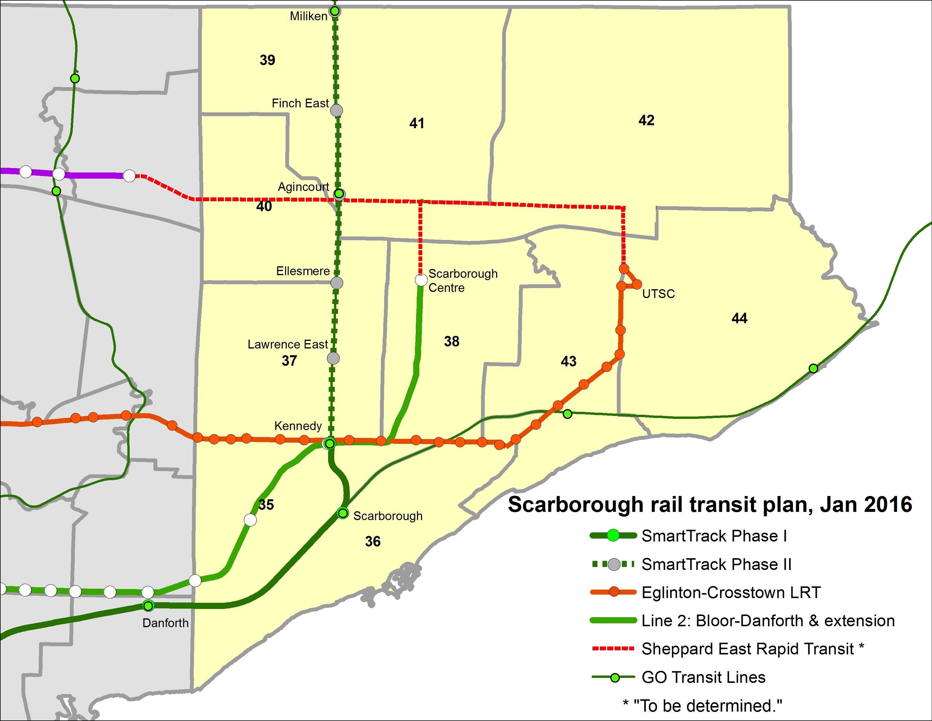
    I created this map below based on a map tweeted by the Star’s Tess Kalinowski on Wednesday afternoon:
    https://twitter.com/TessKalinowski/status/689890493409300484

    Scarborough - 2016The Latest plan for Scarborough, including the one-stop subway extension and the additional 17 stops planned for the Eglinton-Crosstown LRT, as well as SmartTrack Phases I and II, as recommended in a separate study.

    It’s worth noting that the Sheppard East LRT, which won’t start construction until 2021 (essentially leaving it in limbo) is marked on the staff report map as “rapid transit to be determined.” Maybe it will connect to the subway at Scarborough Town Centre. Maybe it will connect to the Eglinton-Crosstown. Maybe it will remain a bus route. In the original Transit City plan, Sheppard East was to be started first; indeed construction did start on the Sheppard Avenue rail underpass at Agincourt GO Station; an empty median is where the LRT tracks are planned to go. The Scarborough-Malvern LRT was supposed to continue north of UTSC to Sheppard Avenue (and potentially further north along Morningside), but this isn’t part of this latest study.

    Transit City planned for a LRT maintenance and storage facility (MSF) on Sheppard East at Conlins Road, near Morningside Avenue. The Conlins MSF would have served three routes: the Sheppard East LRT, the Scarborough RT replacement, and the Scarborough-Malvern LRT. The MSF has been scaled back due to the deferral or cancellation of the other two lines, but will be essential if this latest plan goes through. So the ECLRT is built to UTSC, a rail connection from Sheppard will probably be necessary, and maybe the Sheppard and Crosstown lines were converge here.

    What makes the least sense for me is the long, non-stop section of the subway between Kennedy and Scarborough Centre. There was clearly a problem of having two prioritized high-capacity rail proposals serving similar markets: SmartTrack, and the Scarborough subway extension both championed by the mayor. Cutting out the Sheppard and Lawrence stops delivers passengers to SmartTrack. That is, of course, SmartTrack makes it north of Kennedy Station.

    A separate study by Metrolinx staff, recommending a shorter SmartTrack line between Mount Dennis and Kennedy, along with a western extension of the Eglinton-Crosstown LRT,  was reported in the Globe and Mail last Friday, with the Unionville-Markham section part of a later Phase II. It appears that the City-led Scarborough Transit Planning Study is assuming a full build-out of SmartTrack, at least on the east end.

    I’m happy, though, to see LRT seriously considered as a solution for intermediate transit needs. What I find somewhat ironic, though, is that the Eglinton-Crosstown LRT is becoming what SmartTrack was eighteen months ago: a single line that solves all transit planning problems. Of course, my wish is to go back to building the Scarborough LRT extension, the original Scarborough-Malvern line, and letting Metrolinx and GO Transit do their thing with implementing RER.

    The city planning report notes that “…of the 206,000 transit trips that begin in Scarborough, 99,000 or 48% end in Scarborough. This means that only 14% of all trips that begin and end in Scarborough use transit (99,000 of 692,000).” (Pages 14-15.)

    This is why improving the local transit network – be it streetcars or buses – is so important. We’re often fixated on moving commuters long distances, but we never pay enough attention to short-distance commuters as well. For all the “subways, subways, subways” hot air we’re still hearing from some Scarborough councillors, most of their transit-riding constituents rely on buses. As a friend pointed out, since most of those local trips are by car, we need to ask whether this new plan will make transit more competitive for trips within Scarborough.

    Will we see yet another proposal for Scarborough? I bet we will. Maybe SmartTrack could be routed to a spur to Scarborough Centre (has anyone looked at that?). But at some point, fatigue will set in, and we’ll have to pick something – anything – and build it in order to avoid looking indecisive. But I believe that these planned revisions to SmartTrack, LRT, and the Scarborough subway are steps in the right direction.

  • The least-worst alternative for the Gardiner East

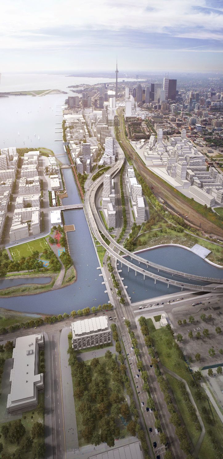
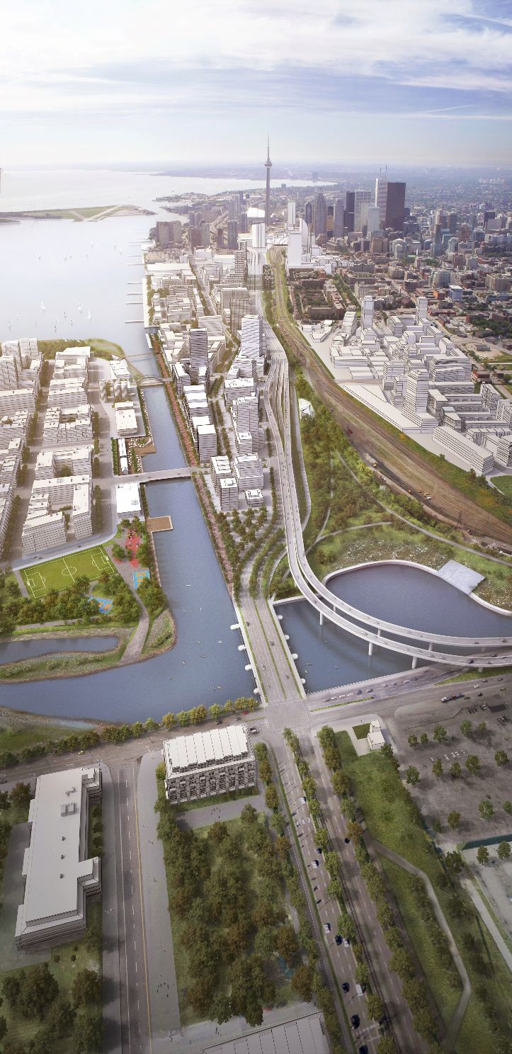
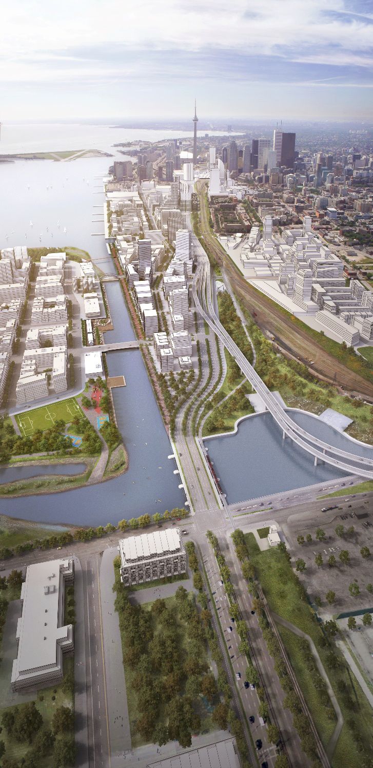
    Back in May, I outlined the reasons why I supported the removal of the elevated Gardiner Expressway east of Jarvis Street. Of the various options, which included maintaining the existing highway, a so-called “hybrid” section that would maintain most of the existing structure, but re-route the section between Cherry Streets and the Don Valley Parkway, and the removal option, which would see a widened Lake Shore Boulevard take over from the demolished freeway, similar to how New York City replaced the elevated West Side Highway.

    The removal option was the cheapest of the three alternatives ($326 million in up-front capital costs and $135 million in ongoing maintenance over a 100-year lifecycle). The study’s traffic models claimed that removal would only increase travel times by 3-5 minutes. Removing the East Gardiner offers the most opportunities to develop the East Harbourfront. Then, I conceded that an eight-lane Lake Shore Boulevard won’t be the most pleasant street to cross, but it won’t be much different than University Avenue.

    But for the benefit of east-end and suburban motorists and several vocal lobbies, council voted 24-21 for the “hybrid” option on June 11, 2015, despite higher costs ($414 million in up-front capital costs, and $505 million in maintenance over a 100-year lifecycle). The relatively close vote was an early test of John Tory’s hold on Toronto City Council.

    Yesterday, the City of Toronto released two important SmartTrack studies. The first was on the projected ridership of Mayor John Tory’s signature campaign promise; the second was on the feasibility of the problematic Eglinton West spur, which observers pretty much expected would be replaced by the planned extension of the Eglinton-Crosstown LRT. Ridership for SmartTrack would be high, but this is predicated on easy transfers, subway-like frequencies, and it being part of the regular TTC fare system. Fifteen-minute service, GO-like fares (which I’ve described as being unfairly expensive for intra-Toronto commutes) and a shorter line will, obviously, reduce ridership, and its relief of the TTC subway. But at least SmartTrack is getting smarter.

    On the same day, we learned more about the City Council-supported “hybrid” options for the Gardiner East as City and Waterfront Toronto staff released detailed assessments on three potential alignments endorsed by the City’s Public Works and Infrastructure Committee. You can view the entire media presentation here.


    Gardiner_media_presentation1     Gardiner_media_presentation2     Gardiner_media_presentation3
             Hybrid 1                             Hybrid 2                          Hybrid 3

    Of the three, “Hybrid 1” is the cheapest to construct, as it uses the existing DVP-Gardiner ramp configuration, but impacts the naturalization of the mouth of the Don River, necessary for flood mitigation. By largely using existing infrastructure, it also minimizes construction delays. “Hybrid” concepts 2 and 3 move the ramps north, but they would be tighter, reducing traffic speeds. These two alternatives also open up more land for development.

    “Hybrid 3” is preferred in all areas except for cost, as it has the greatest potential for development and has the least impact on the planned naturalization of the mouth of the Don. It’s estimated that “Hybrid 3” will cost $569 million to build, and $483 million in long-term maintenance costs, for a total of $1.052 billion. “Hybrid 1” would cost $424 to build, and $482 million in long-term maintenance costs.


    CriteriaCriteria for the three Hybrid options, from slide 39 of the City of Toronto media presentation

    As per David Rider’s report in the Star, we should expect that City and Waterfront Toronto staff expect to recommend “Hybrid 3” to the public works committee and city council. Local councillor Pam McConnell, who backed the “remove” option and still prefers it, will likely endorse the “Hybrid 3” alignment as well, as it delivers the most benefits to the community.

    I’m still disappointed by last year’s vote to keep the Gardiner Expressway up, but I’ll concur with Councillor McConnell. If Mayor Tory and Council are determined to keep the unnecessary eastern section of the Gardiner Expressway up, it should be backing the least-worst option for doing so.

  • A vision for King Street

    21207239313_0c5746b3f8_o

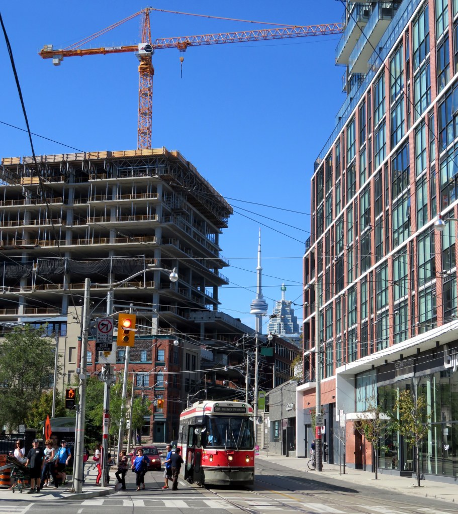
    In today’s Toronto Star, city columnist Ed Keenan reports on the “King Street Visioning Study,” a city planning project that will soon be available for public feedback. The study proposes improving streetcar operations along the King Street Corridor between Dufferin and Parliament Streets as well improving the public realm, making it a more pleasant place to walk. The 504 King Streetcar is the busiest surface route in the TTC’s system, and as I, and many others, have said before, the streetcar needs to be able to move more people more efficiently. But now City Planning is leading the study, not the TTC, making this a more holistic vision for King Street.

    Chief City Planner Jennifer Keesmaat says that it’s “reasonable” that the initial pilot projects could be started in early 2017. Work has already been contracted to some of the same firms that were responsible for transforming Queen’s Quay (which despite some construction delays, and conflicts in a few places between pedestrians, cyclists, and motorists, is a fantastic project).

    Keesmaat echoes previous attempts at creating a King Street Transit Mall, suggesting a similar system of alternating one-way sections that would provide for taxis, deliveries and passenger drop-offs and pick-ups, but forcing through traffic onto parallel streets. Extending transit priority all the way from Dufferin to Parliament could do a lot to streetcar improve operations, especially as the TTC is planning a new 514 route on King between Dufferin and Cherry Streets to supplement the overburdened 504 line and better serve the West Donlands, Distillery District, and Liberty Village.

    Yes, King Street improvements would start off as pilot projects, much like the bicycle lanes on nearby Richmond and Adelaide Streets, or the decade-old 2-hour transfer on St. Clair Avenue, or the Toronto Hydro ALAMP street lighting trials that should have concluded years ago. (Toronto seems to like permanent pilot projects.) That said, previous plans for a King Street transit mall never even got to the “pilot project” phase.

    But hearing that pedestrians and transit will be getting priority is music to my ears. Knowing that City Planning, and not just the TTC, is looking at this gives me optimism that this could finally go ahead. There will be opposition from businesses along the corridor, taxi drivers, suburban politicians concerned about a non-existent “war on the car.” And it’s not clear if Mayor John Tory is in favour, or a majority of city councillors.

    An improved public realm is especially appropriate on King Street, especially through historic Old York on the east and the cultural and tourist draws of the Entertainment District on the west. Sidewalks are often crowded, especially as the theatres get out in the evening, but with such diverse uses along the corridor, from bank towers to night clubs, King is one of Toronto’s most vibrant streets. Toronto often has trouble with attractive streetscaping (thanks to ugly wooden poles and overhead wires, cheap, grey street furniture, and ugly traffic signals), but it has recently managed to get Queen’s Quay (mostly) right.

    As for design, I’m hoping for something interesting and something different. I’d do away with the Muskoka chairs mentioned in Keenan’s article. They’re wonderful on Toronto’s waterfront, but I’d like to see some imagination on King Street. What about seating shaped like director’s chairs in front of the TIFF Lightbox? (Oh, and on the subject of TIFF, could we tell film festival organizers to stuff it when they want to wreck the King Streetcar again in 2016?)

    After years of talk about fixing King Street, there’s a very serious proposal to do something about it. Maybe the third time’s the charm.

  • A smarter SmartTrack

    ST - Before 2016
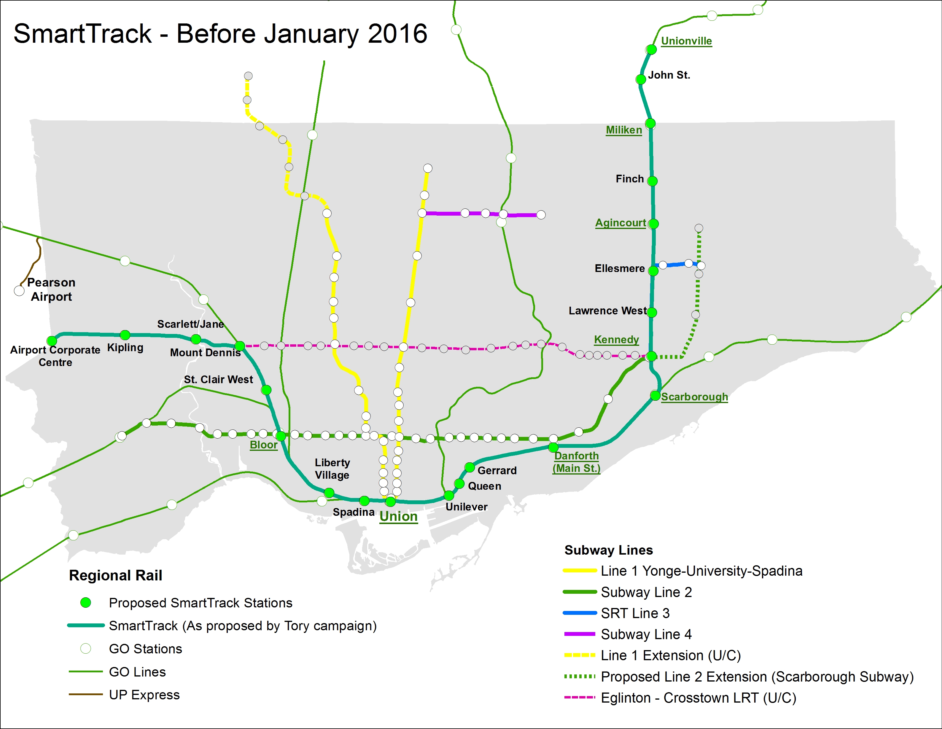
    John Tory’s original SmartTrack plan, shown with the existing TTC Subway and GO Rail networks. 

    In Friday’s Globe and Mail, we were treated to a scoop by Oliver Moore, that newspaper’s excellent transportation reporter, on behind-the-scenes revisions to Mayor John Tory’s SmartTrack rail transit platform, a topic that I discussed several times in this blog.

    Tory’s SmartTrack plan, dreamed up by a private-sector planning firm, was intended to connect office parks in Mississauga and Markham to Downtown Toronto, as well as serve the proposed First Gulf development at the Unilever site near the mouth of the Don River. Tory promised that it would provide relief to Toronto’s overburdened subway system, but that was never the main objective.

    I have been aware of rumours that Tory’s SmartTrack plan was going to be walked back due to mounting costs and technical issues of implementing the mayor’s campaign promise. The team that came up with the idea of a U-shaped rail network intended to connect several suburban employment centres with Downtown Toronto overlooked some important details, such as the availability of land along the former Richview Expressway corridor along Eglinton Avenue West. SRRA, the private-sector planning organization that came up with SmartTrack, assumed that the Richview lands were available and owned by the province, but the city owned the land, and sold much of it off for development in 2011 and 2012.

    The cost of building the western spur between Mount Dennis and the Airport Corporate Centre was, in all likelihood, found to be prohibitive, though we have yet to find out what the estimated costs for a tunnel along that section. The eastern section, north of Kennedy Station, would have closely paralleled both the Scarborough RT and the proposed extension of the Bloor-Danforth Subway to McCowan Road, a project that Tory also backed.

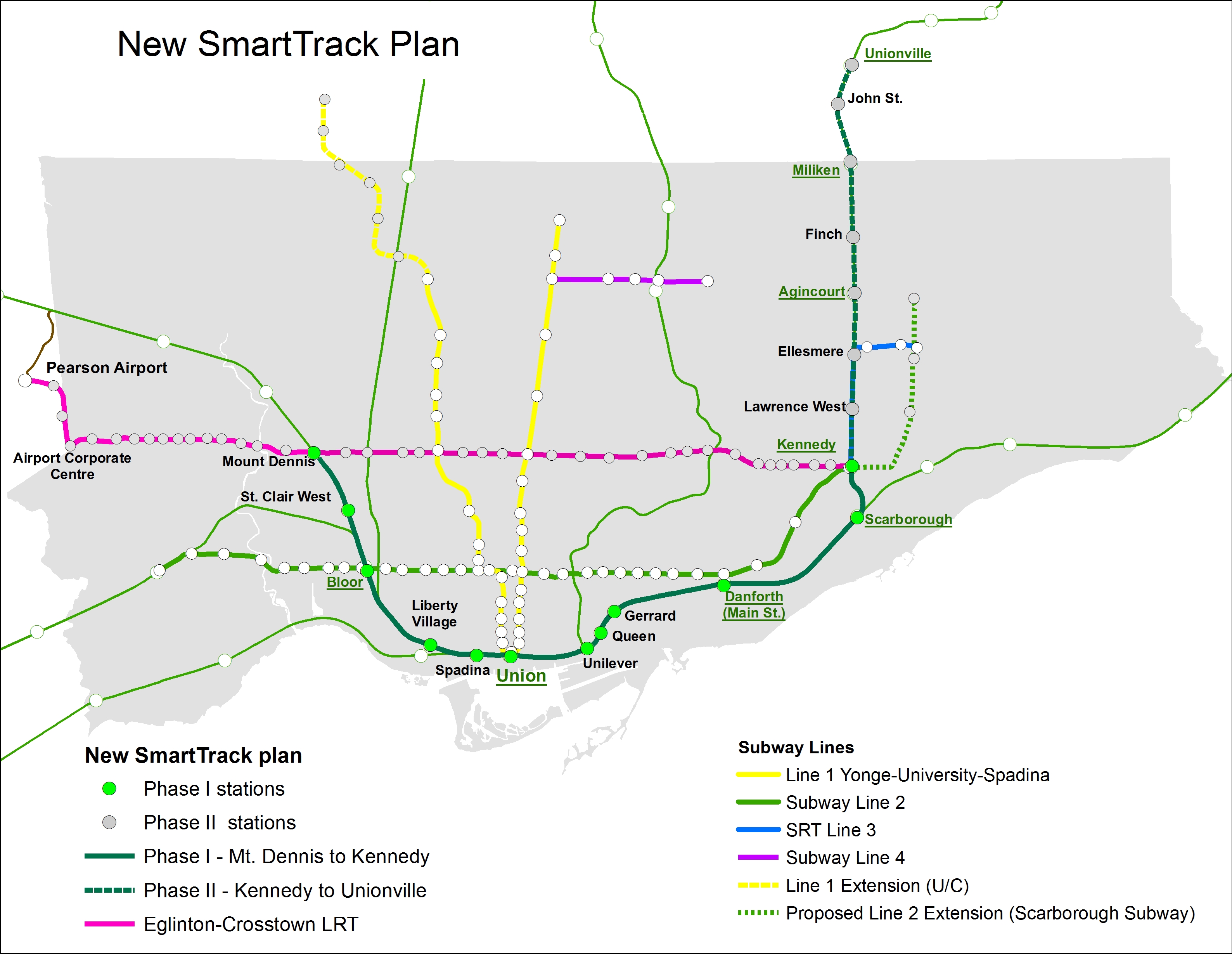
    The Globe and Mail’s Oliver Moore reports that SmartTrack will cover a much shorter section than the map on John Tory’s 2014 campaign brochures. Frequent rail service will complement existing GO Transit Regional Express Rail (RER) services on the Kitchener and Stouffville Corridors, terminating at Mount Dennis and Kennedy Stations. The Eglinton West section will be covered by the “shovel-ready” Phase II of the Eglinton-Crosstown light rail transit line (ECLRT), which is already under construction east of Mount Dennis. (The provincial government deferred funding for this section of the ECLRT in 2010 for budgetary reasons.) The north-eastern section of SmartTrack, between Kennedy Station and Unionville Station in Markham, will be deferred.

    This new plan, which is being finalized and will likely be officially announced later this year, will cost an additional $2-billion to $3.5-billion to the existing plans for RER, in order to facilitate more frequent, subway-like frequencies, as well as complete the western section of the ECLRT.

    If Moore’s reporting is accurate (and I have seen maps and other materials that collaborate his report), then Tory will have to eat some crow. Spin doctors will have to figure out how to polish this turd as Tory seeks a second mandate in 2018. It’s also inevitable that the new additional service on this corridor will continue to be branded as “SmartTrack.” But this is the best solution, and maybe this is a sign that Tory is learning on the job.

    At the end of the day, what Toronto gets is what Metrolinx’s “Big Move” plan envisioned: upgrades of most GO Transit corridors to RER, as well as Phase II of the Eglinton-Crosstown LRT line to Pearson Airport. (The Finch West and Sheppard East LRTs are also approved, but have yet to start construction.) The paired-down SmartTrack plan, if trains are frequent enough, and with attractive transfers with the subway and TTC surface routes, will draw some riders. It could help provide medium-term relief as the [Downtown] Relief Line Subway is studied and built.

    New SmartTrack PlanThe new SmartTrack plan, including Phase II of the Eglinton-Crosstown LRT

    But where I find myself annoyed is when I realize that we wasted over a year on Tory’s campaign slogan without any progress on the Relief Line (which will offer real, long-term relief to the Yonge Subway), the Waterfront West LRT, or other transit priorities such as accessibility at all existing subway stations. I remember during the 2014 election campaign, critics of Tory’s simplistic and flawed SmartTrack plan were dismissed without acknowledging their objections. It’s also worth noting that Tory also adopted rival Olivia Chow’s bus plan, after belittling it during the campaign.

    In order to provide fast and reliable transit to the Airport Corporate Centre and Pearson Airport itself, there are opportunities to refine the western section of the Eglinton-Crosstown LRT. The environmental assessment called for 15 stops between Mount Dennis and Pearson Airport, while SmartTrack would have had as few as three stops along the same section. If the ECLRT can be sped up at all, it would be worth considering. I would also be interested in whether the SmartTrack corridor could be integrated with the UP Express rail link, whose ridership started off quite low.

    And maybe, just maybe, the high costs of constructing the Scarborough Subway extension will also prompt a rethink, going back to the original LRT replacement and extension plan. As the Spadina Subway extension to York University and Vaughan is now two years late (and yet another $400 million over-budget), maybe there’s an opportunity to get it right there as well. It’s also imperative that proponents of the Relief Line Subway strike now.

    I could be giddy with the revelation that Mayor Tory’s signature campaign platform is coming undone, having foreseen the problems with his plan. But I’m not. However, I do take pleasure in knowing that we have a smarter plan in the works.


  • Metrolinx’s strange priorities

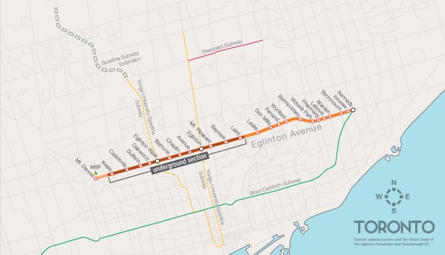
    crosstownroutemaplarge-640x367Map of the Eglinton Crosstown LRT showing the original working station names along the corridor

    It’s too often that we hear from business leaders, planning experts, and pundits that politicians should be kept out of transit planning. To some degree, this makes sense. We saw what happened when politicians, pandering for votes from Scarborough, derailed a viable, ready-to-go transit plan in favour of a shiny, unfunded, subway line.

    Metrolinx’s appointed board is made up of developers, business people, advisers, administrators, and two retired politicians. It seems like the kind of place where smart, level-headed, apolitical decisions could be made. That is, until board members start bickering about station names.

    In December, Metrolinx rubber-stamped, with little debate, a problematic GO Transit fare increase. But it then spent four times as long debating the names of three stops on the Eglinton-Crosstown LRT corridor. And today, there will be a special teleconference meeting to decide – hopefully once and for all, these three names. Maybe then they can get on to serious business.

    I discuss this further in Torontoist this morning.

  • On the 2016 City of Toronto budget (Updated)

    Updated Jan. 12 with a thought on a progressive property tax. 

    It’s budget time at Toronto City Hall. Right now, city councillors are in the process of debating the city’s expenses and revenues. While the City of Toronto, like all municipalities in the province, is prohibited from operating at a deficit, there’s a ever-growing gap between revenue (taxes, fees, grants, etc.) and the necessary operating and capital expenses required to successfully run a city of 2.6 million people.

    Operating expenses are being held back due to “gapping,” in which vacant staff positions aren’t filled immediately. This is an easy way to cut costs, especially at a time when all city departments – the Toronto Police Service excepted – were requested by Mayor John Tory to reduce costs by 2 percent. But as Neville Park explains in Torontoist, this is not a viable long-term strategy.

    Meanwhile, the capital costs keep piling up. The Toronto Community Housing Corporation (TCHC) has hundreds of uninhabitable units; thousands more are at risk of being closed up unless its capital backlog is addressed. The Toronto Transit Commission (TTC) has a backlog of state-of-good-repair projects necessary to maintain its sophisticated transit system operating, as well as unfunded projects to improve accessibility and purchases of new vehicles to keep up with demand and grow ridership.
    2016Budget
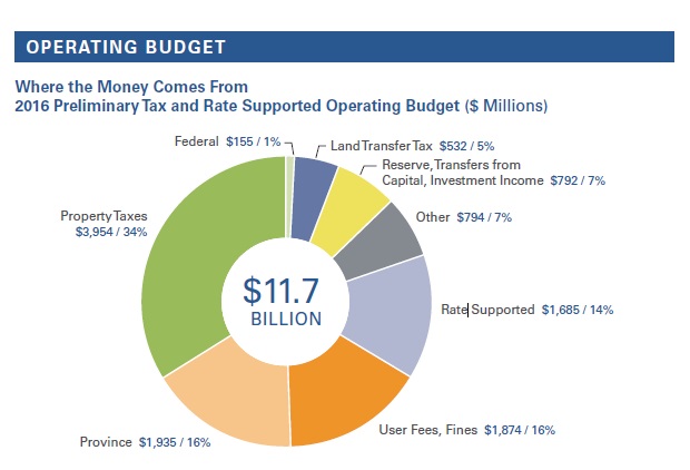
    Estimated City of Toronto 2016 operating budget revenue (source)

    In 2016, $3.95 billion will be collected from property taxes in order to fund the City of Toronto’s operating budget, just over a third of all revenue. It’s the largest source of revenue, but provincial grants, user fees (such as TTC fares) and fines, water and waste management charges are other important sources of revenue. The much-loathed municipal land transfer tax will contribute $532 million to the city’s budget, an increasingly important source of revenue. But there’s still a projected gap, estimated between $90 and $124 million, that still has to be filled. That’s where the debate will largely focus on.

    Property taxes mostly do not fund the city’s capital budget; utility and parking rates are the largest single-source of funds (water, waste and city parking are self-financing), followed by provincial and federal grants (largely to fund transit and other infrastructure), development fees, and debt-financing and from the city’s capital reserves.

    Mayor Tory, despite wanting to hold the line on expenses, also wants to build his signature – yet unrealistic – SmartTrack line, among other transit projects, as well as social housing. He proposed a new levy (not calling it a “tax”) in December, if approved, it would be phased-in, starting in 2017.

    I’ve been critical of Mayor Tory’s administration, but his proposed infrastructure levy is a step in the right direction. It’s an acknowledgement that the backlog of necessary capital projects needs to be addressed.

    But I was concerned to read last week in the Toronto Star that senior city staff and Tory’s advisers were considering, even laying some of the groundwork, for a sale of a minority stake of Toronto Hydro to pay for new infrastructure. While it might raise $1.5 billion, it would be a one-time source of funds, and would reduce or eliminate an annual dividend that raised $60 million for the city in 2014. There were also rumours of a partial or complete sale of the Toronto Parking Authority. But responding in the Toronto Sun, Tory denied having such plans.

    The City of Toronto desperately needs to seek new, stable, and sustainable revenue sources beyond the property tax and user fees, neither of which are progressive or especially fair. Reinstating the vehicle registration tax would be a good place to start, at least to fund the city’s unfunded anti-poverty strategy, but income and sales taxes, currently prohibited by provincial legislation, tied to inflation, would help. So would increased, sustained provincial and federal assistance.

    You can find out more about the 2016 budget at the city’s website here. I’m not following the debates that closely, but Torontoist can be counted on for good issue-based coverage, the Toronto Star’s Ed Keenan provides excellent commentary.


    On property taxes, current value assessments, and a progressive property tax

    Property taxes are a very difficult subject to explain, but David Hains at Torontoist explains how they work far better than I, or most people, can. Property taxes are not well understood, but it’s important to note that despite rising property values, the city does not necessarily collect more taxes on each property. In many cases, even with a tax hike, the amount paid by some property owners may stay the same, or even decrease.

    Property taxes provide a predictable and reliable revenue source, but unlike income and sales taxes, they do not increase automatically with inflation; annual tax increases determined by City Council allows the city budget to grow with inflation and support city priorities, such as improved transit, infrastructure repairs, or other city services.

    The city is also phasing in changes to property taxes in order to reduce the burden on commercial properties (including multi-unit residential rental buildings) and increase it on freehold units. This is why, in 2013, I received a rent reduction notice as the property taxes in the apartment building I was living in at the time was reduced.

    To satisfy my interest in property taxes, property values, and assessments, I created three maps based on a City of Toronto 2016 budget briefing note on changes to the current value assessment (CVA) from 2015 to 2016. The Municipal Property Assessment Corporation (MPAC) conducts property tax assessments for all properties on behalf of municipal governments in Ontario every four years. It is upon these assessments that the city calculates each property’s tax rates.

    The first map, below, shows the average assessed residential property value for 2016, using a standard deviation classification scheme. Ward 25 has, by far, the highest average property value, at $1,375,568. Ward 25 includes the exclusive Bridle Path neighbourhood, as well as the affluent Lawrence Park East and York Mills neighbourhoods. Other Midtown Wards (16, 22, 21) are well above the city’s average property value, assessed at $549,586. Lowest is Ward 8, whose average residential property is assessed at $301,320.

    It’s interesting to note that, with the exception of Ward 4, which narrowly voted for Doug Ford in 2014, the map closely resembles that of John Tory’s support base.
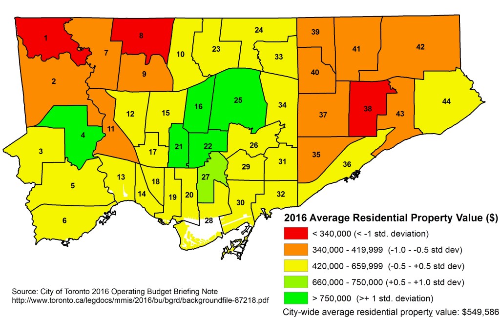
    2016 Average Residential Propery Value std deviation

    The second map, below, shows the change in the average CVA in each ward. Ward 18, which includes the gentrified or gentrifying Queen West, Brockton, Junction Triangle, and Dovercourt Village neighbourhoods had the highest annual average CVA increase, at 6.6 percent. Other downtown wards, such as 14 (which includes gentrifying Parkdale, Roncesvalles, and part of the Junction), 19, and 28 did well, as well as Wards 23, 24 and 41 in the suburbs. The northwest had the smallest average increases in assessments, with Ward 8 again coming in at the bottom, with only a 3.3% increase.
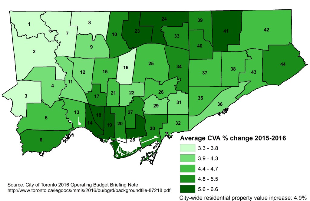
    CVA Change 2015-2016

    Finally, the map below shows the entire aggregate value of residential assessments in 2016. Not surprisingly, Wards along the dense Yonge Street corridor had the highest values. Except for Wards 16 and 25, all have higher than average ward populations, and housing in most neighbourhoods largely consists of expensive detached houses and highrise condominiums.
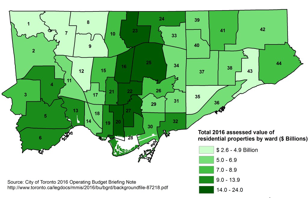
    2016 Total Residential Propery Values

    In today’s Toronto Star, Ryerson Professor (and friend) Myer Siemiatycki discusses the idea of a progressive property tax. A progressive property tax would be similar to income taxes, in which tax brackets are set up, lowering taxes on lower-value properties, and raising them on properties with high assessed values. Siemiatycki proposes that a first bracket, if a system was implemented this year, would ensure that properties worth under $400,000 would pay less property tax than they paid in 2015. A second bracket would apply to properties assessed at between $400,000 to $600,000, which would be subject to the currently proposed tax increase. Properties worth over $600,000 would be subject to higher property tax increases, the highest bracket topping out at properties worth over $2.5 million. Siemiatycki argues that the most expensive properties have benefited most from Toronto’s increasing housing prices.

    This is an interesting idea that would raise more revenue for the City of Toronto, give many “Ford Nation” residents a tax reduction, and provide more fairness in the flat property tax rate. It would be much more easily implementable than, say, sales and income taxes. But given that John Tory’s base (and wards represented by some of his staunchest allies) would be most affected by such a progressive tax system, I don’t hold out much hope for its adoption.