Category: Toronto

  • Two buildings that truly define Toronto

    City of Toronto Archives, Fonds 1526, File 46, Item 12. Creator, Harvey R. Naylor
    City of Toronto Archives, Fonds 1526, File 46, Item 12

    The first tower of the Toronto-Dominion Centre, from Front and Church Streets, 1967

    Back in May and June of 2015, the Guardian newspaper ran an intriguing series on its Cities page entitled “A history of cities in fifty buildings.” The list is quite interesting: it includes several buildings no longer standing, such as the infamous Pruitt-Igoe housing complex in Saint Louis, Missouri, and the World Trade Center in New York, and some iconic, transformative landmarks such as the Guggenheim Museum in Bilbao, Spain, and even the first Starbucks location in Pike Place Market, Seattle.

    In Toronto, the Guardian chose Honest Ed’s as Toronto’s entry on the list. Of course, the Guardian’s list wasn’t meant to include the world’s most famous or iconic buildings, but chose an assortment of structures, standing, demolished — or in Honest Ed’s case, imperiled — meant to “tell unique stories of our urban history.”

    [Disclosure: I contributed to the Guardian Cities site in February, 2015, discussing new streetcar systems in American cities.]

    Over six months later, the Toronto Star finally noticed the Guardian’s inclusion of Honest Ed’s in its list of fifty buildings. The Star sought the opinion of two local architecture professors, Vincent Hui, of Ryerson University, and David Lieberman, of the University of Toronto. Hui agrees with Honest Ed’s inclusion, while Lieberman says that “at first glance, [the Guardian’s series] is a really dumb list.”

    In some ways, Honest Ed’s — that kitschy emporium of bargains, bad puns, and faded memorabilia, fits the criteria of the Guardian’s list. The store was innovative (it was one of the first stores to feature “loss leaders” and store greeters), it served the needs of Toronto’s growing post-war immigrant communities, and was the starting point for a larger empire that included theatres in Toronto and London. The store’s replacement by a new mixed use development proposed by Westbank, is also part of Toronto’s story, as it becomes an increasingly high-rise city. So I agree with its inclusion in the Guardian’s list, based on the newspaper’s interesting (and provocative) criteria.

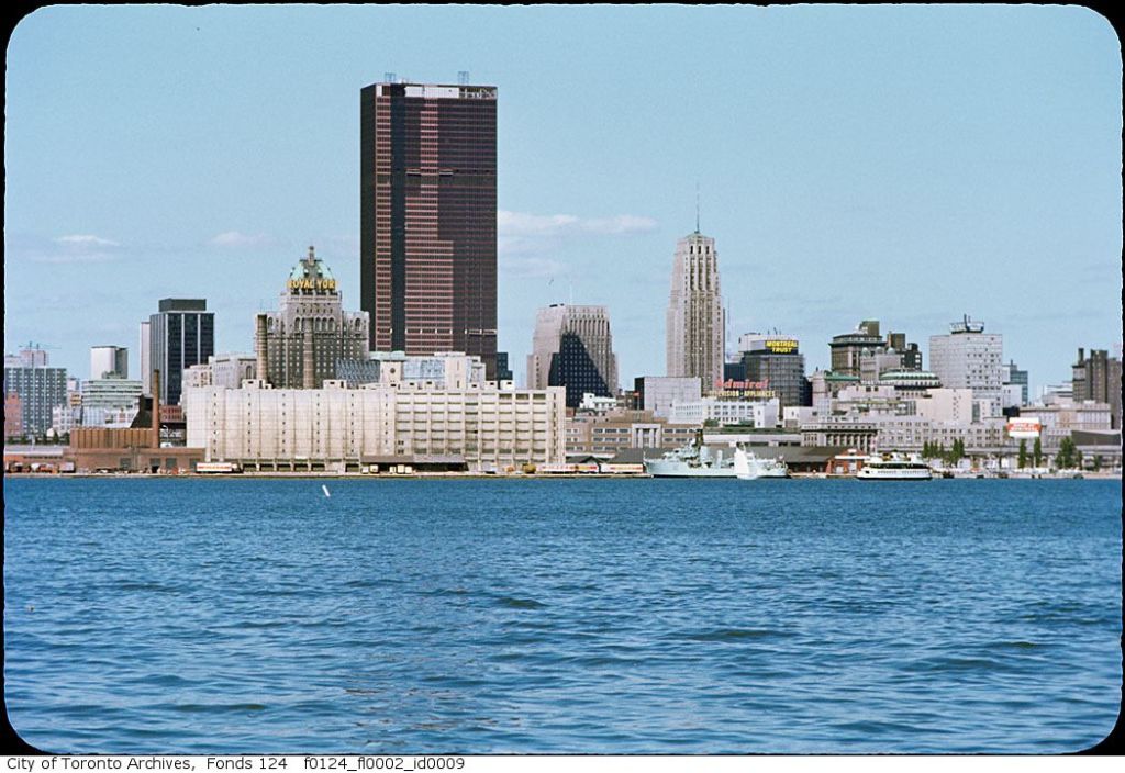
    But if you were to ask me, I’d select two different buildings that would best represent Toronto’s modern history: the Toronto-Dominion Centre and City Hall.

    f0124_fl0002_id0009
    City of Toronto Archives, Fonds 124, File 2, Item 9

    (more…)

  • King Street: a mess of Uber proportions

    21207239313_0c5746b3f8_o

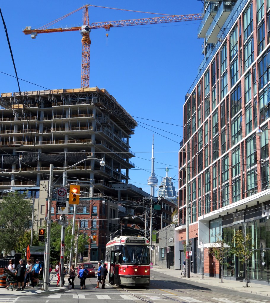
    One of the most frustrating things about living and working in central Toronto is having to rely on streetcars for east-west travel. This isn’t the fault of the streetcars; when free of traffic, they’re a smooth, fast and comfortable way to get around. But trapped in the quagmire that is downtown traffic, streetcars are painfully slow. They’re stuck behind left-turning cars and trucks. Cars plugging the curb lane, legally or not, force all traffic into the streetcars’ path. Replacing streetcars with buses isn’t a solution either; not only would more buses (and drivers) be required to match the each streetcar’s superior capacity, but buses would be forced to weave in and out of the curb lane around taxis, parked cars, delivery vans and other obstructions.

    Rapid residential growth, both east and west of the downtown core, have overloaded the 504 King Streetcar. With 64,600 daily riders, it’s the busiest surface route in the system. The city has done little to facilitate this highrise boom in neighbbourhoods such as Corktown and the Distillery District in the east, and CityPlace, Liberty Village, Niagara, and Queen/Gladstone in the west. Further west, the highrise condos built at Humber Bay Shores must either rely on a painfully slow and unreliable ride on the 501 Queen Streetcar, take an infrequent double-fare express bus, or ride a bus up to the Bloor Subway.

    No wonder then, Uber, the controversial firm that has delighted passengers with cheap transportation, but put the livelihoods of taxi drivers in jeopardy, launched UberHop, a variation of its “ride sharing” service that offers flat $5 rides between neighbourhoods along the King Streetcar and the downtown core. From a purely capitalist viewpoint, Uber is filling a need that’s been left unfulfilled.

    (more…)

  • It’s time for two-hour transfers on the TTC

    15102078722_2ee5e4e9e3_k

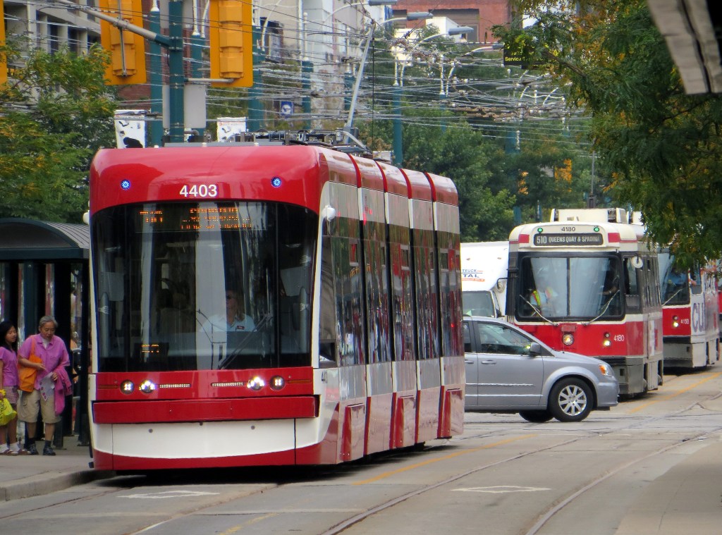
    As of Monday, December 14, all TTC streetcars will operate under a “proof-of-payment” system; allowing customers to enter through the rear doors, as they currently do on 509 Harbourfront and 510 Spadina, the two routes partially equipped with the new Bombardier low-floor streetcars. All-door loading and proof-of-payment (POP) is supposed to be in effect on streetcars on Queen Street, but in practice, operators inconsistently open the rear doors; sometimes at all stops, often just a few downtown stops, sometimes only at Yonge Street, sometimes not all.

    This new policy requires passengers to have a valid pass, transfer, or Presto card on board every streetcar; fares can continue to be paid at the front door on the older CLRVs and ALRVs; at that point a transfer must be obtained.

    TTC fare inspectors have been handing out brochures about the new policy to streetcar passengers, informing them about the upcoming change:

    The design of the new low-floor streetcars has required POP: they have four doors instead of two doors on CLRVs and three on ALRVs; the operator is in a separated cab, and normally does not interact with passengers, including fare collection and handing out transfers. At this point, at the end of 2015, all streetcars on the 509 and 510, as well as the 505 Dundas and 511 Bathurst routes were supposed to be equipped with low-floor accessible streetcars, but the many delays at Bombardier has resulted in only the twelfth new streetcar, #4413, entering service today.

    By the end of the year, all TTC streetcars (not just the new Bombardier LFLRVs) will be accepting payment by Presto Card, one small step towards the elimination of tickets, tokens and paper transfers, a process already complete at many suburban GTA transit agencies.

    But widespread adoption of Presto at the TTC will result in a few challenges unique to it, thanks to its outdated transfer policy that dates back over 100 years.

    On the TTC, transfers are only valid for continuous one-way trips, no stopovers permitted. But most other major systems in Ontario work on the time-based transfer system, that allows for stopovers, even return trips within a 90 minute period (the policy at Grand River Transit) or 120 minute period (permitted in Mississauga, Brampton, York Region, Hamilton and elsewhere). After boarding the first bus, each additional tap with a Presto card will not result in a new fare deducted until the 90 minute or two hour time limit has passed.

    The TTC will have a different policy. Paper transfers will still be required for Presto card holders if they intend to transfer to a bus (Presto readers will not be coming to the TTC’s buses for another year); but transfers to connecting streetcars and subway stations can be done by tapping the card on the new vehicle or at the subway turnstile. If it’s a valid transfer under the TTC’s rules, it will not deduct another fare. Here’s the TTC’s Brad Ross (the TTC’s amazing Head of Communications) clarifying this:

    https://twitter.com/bradTTC/status/672810002688569344

    But there’s a hiccup:

    https://twitter.com/bradTTC/status/672841401177014272
    https://twitter.com/bradTTC/status/672841244918210560

    If a passenger taps onto another vehicle on the same route, which is quite a common occurrence due to delays, short-turns, and diversions/shuttles, the Presto Card will deduct a second fare.

    There is an easy solution: two-hour transfers. It would eliminate confusion, allow for short stopovers and quick two-way trips, and solve such issues such as customers re-boarding streetcars and buses on the same route. Allowing Presto cardholders the same luxury as that enjoyed in Toronto’s suburbs would provide an incentive to passengers paying by cash and token to switch. After all, the TTC already offers a two-hour transfer on St. Clair Avenue, a pilot project left over from the construction of the streetcar right-of-way.

    The TTC already considered at time-based transfers in 2014 as it planned for the transition to Presto for fare collection. The Commission estimated that it would cost $20 million in annual revenue (thanks to lost fares stopovers and single-fare return trips), but it would by a lot of goodwill. And I doubt that the TTC would lose $20 million a year as it might attract new riders, especially during off-peak periods.

    It’s now time for the TTC to bite the bullet to make it easier to ride the rocket.

  • The Golden Horseshoe’s missing links

    14182301824_167b4e754a_k
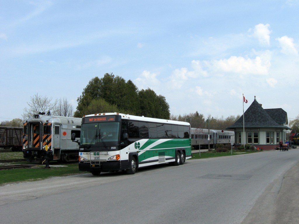
    GO Transit bus at Uxbridge

    Over the last 15 years, GO Transit has done well expanding its bus and rail operations. It opened up new stations, such as Mount Pleasant, Lincolnville, Barrie South, Allandale Waterfront, and West Harbour. It introduced the Highway 407 service, finally making York University accessible to thousands of suburban students. And it extended its reach to Waterloo and Peterborough, not only serving post-secondary institutions and residents in those cities, but also making it easier for cyclists like myself to explore new trails and destinations.

    But as GO Transit expands, there are many gaps, large and small, that should be closed. Coinciding with GO Transit’s expansion, intercity bus operators have been cutting back; dozens of Ontario towns and cities no longer have any coach service, and many more have saw their service cut back. Several municipalities in GO’s service area have resisted operating local transit systems, and GO’s use of park-and-ride lots has made their bus services difficult to reach without a car. In this post, I discuss some of these challenges.


    Related:

    (more…)

  • Mapping Toronto’s homeless shelters: an interactive mapping exercise

    Earlier this week,  I mapped the locations of Toronto’s homeless shelters for Torontoist. While there are shelters located across the city, the capacity is located almost entirely within the old city of Toronto, especially in the Downtown east side, between Church Street and the Don River. This is despite the fact that the need for shelters, like all social services and affordable housing, is city wide. I obtained the homeless shelter data from the City of Toronto’s Open Data catalog.

    https://seanmarshall1.cartodb.com/viz/418097ea-71f9-11e5-8d00-0e787de82d45/embed_map

    Unlike previous mapping exercises, I used CartoDB to create an interactive map, rather than relying on Quantum GIS (open source GIS software) or ESRI ArcGIS (software developed and maintained by the leading GIS firm) to create static maps. Importing data into CartoDB is quite easy; the selection of simple base maps is also very helpful. Creating legends and classifications had a bit of a learning curve, but on the whole, I was quite pleased with the result.

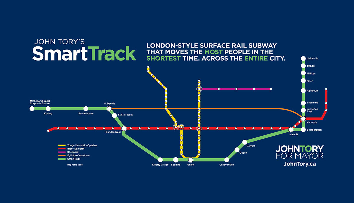
  • Not so FAST: SmartTrack gets a lobby group, raises many questions (Updated)

    smarttrack_fb
    I find myself feeling frustrated, worn down, and at times angry about this federal election that’s thankfully coming to an end on Monday. As a progressive voter, I’ve been disappointed by Thomas Mulcair and the New Democrats, for reasons that Desmond Cole explains so very well in today’s Toronto Star. (Locally, I ‘ve been supporting the NDP’s Linda McQuaig in Toronto Centre, whose progressive credentials are impeccable.) The bright side is that Stephen Harper’s Conservatives are going down to an almost-certain defeat, hopefully taking their narrow and divisive targeted politics with them. My wish is for a minority government in which the Liberals and New Democrats share power; this may check the Liberals’ record of running left and governing right.

    Happily, Torontonians also have the Blue Jays and municipal politics to watch. Last night, we all got to watch the strangest seventh inning in baseball history; today, we get to snicker at the efforts of an Astroturfing crew of lobbyists pushing SmartTrack – a mayoral campaign slogan masquerading as a transit plan. Municipal politics may be at times just as depressing as provincial or federal politics, but at least it’s a lot more fun.

    The Toronto Star’s fantastic transportation reporter, Tess Kalinowski, reported on a new booster group, known as FAST (Friends & Allies of SmartTrack). Its spokesperson would be Alvin Curling, a former provincial Liberal cabinet minister and Speaker of the Provincial Parliament. Other members of its Public Advisory Board include Kyle Rae, former city councillor who is now a City Hall lobbyist, and three prominent lawyers  – Andrea Geddes Poole, Michael Brooks, and David S. Young. Also involved is one Tom Allison. 

    According to a press release, FAST claims it’s “here to advocate for SmartTrack and to educate the public about how it could make a huge difference in cutting congestion and moving people around the region.” It would raise funds “devoted to creating a variety of awareness campaigns such as town halls and informational videos.” 

    FAST’s website – launched today – is comically full of spelling and syntax errors, misinformation, and complete fabrications of basic facts. Here are just a few. (more…)

  • A disappointing step backwards for ranked ballots

    I’ve long been a fan of ranked ballots, a voting system that Dave Meslin and the good people at RaBIT have been promoting for a long time. At the municipal level, ranked ballots —also known as instant run-off voting — is a simple, yet effective way of improving local democracy.

    Ranked ballots ensure that politicians are elected because they can enjoy the support of a majority of electors, so they are fairer than the first-past-the-post system we currently use to elect city councillors. To some degree, it reduces the advantage that incumbent councillors enjoy due to name recognition, and they promote diversity in local politics. I think they’re a better idea than term limits, recalls, or municipal parties.

    The provincial government is currently reviewing the Municipal Elections Act; reforms may allow municipalities to adopt ranked ballots. At first the City of Toronto seemed to be eager to sign on; in 2013, Council adopted a motion to ask the province to allow ranked ballots to replace the current electoral system; more recently Mayor John Tory expressed his support for the idea.

    But during a recent council meeting, newly-elected Councillor Justin Di Ciano (Ward 5) just threw a wrench into the works. Calling ranked ballots “confusing,” he put forward a motion to ask the province not to allow ranked ballots. It passed, 25-18.

    The map below illustrates the result of that vote by ward.

    Ranked ballots vote

    Incumbent councillors might be wary of ranked ballots, especially if they face multiple opponents. Fifteen councillors (and Mayor Tory) were elected with less than 50% of the vote; they would be vulnerable to ranked ballots. Three of those councillors: Ana Bailão (Ward 18), Joe Cressy (Ward 20), and Raymond Cho (Ward 42), were brave enough to vote the right way on Di Ciano’s motion.

    Conversely, councillors such as Norm Kelly (Ward 40, who won with 86% of the vote), Michael Thompson (Ward 37, 84%) and Jaye Robinson (Ward 25, 83%) voted for the motion. Justin Di Ciano himself won with 54% of the vote in Ward 5. The “yes” votes were mostly from Council’s right wing, but left leaning councillors such as Maria Augimeri (Ward 9) and Paula Fletcher (Ward 30) joined in. Augimeri would have almost definitely lost in 2010 had ranked ballots been adopted; it’s possible that Fletcher would have been voted out in 2010 and in 2014 under this voting system.

    2014 Election - Councillor win percentMap of the share of votes each councillor was elected by in 2014.  

    The fight for ranked ballots is far from over; Mayor Tory still has plenty of political capital and sway with the provincial government. I’m hopeful that council will reverse itself yet again.

    In happier news, Council voted 25-18 in favour of asking the province to allow non-citizen permanent residents to vote in municipal elections. As local government is closest to the people, and makes decisions that affect most individuals on a day-to-day basis, I am in favour of such a move. That said, I still believe that electing federal and provincial representatives should remain a privilege afforded to Canadian citizens.

  • Exploring the downtown federal election races: Part II

    Back in April 2015, I looked at the impact of changes to the new federal electoral districts in three key downtown races: Toronto Centre, University-Rosedale, and Spadina-Fort York. The three downtown ridings were created by splitting two larger electoral districts, Trinity-Spadina and a larger Toronto Centre.

    As a downtown resident and political junkie, I was very interested in how previous election results would look with the new electoral districts. Could Toronto Centre, long held by the Liberals, go orange with Rosedale and Yorkville lopped off? Would University-Rosedale and Spadina-Fort York become Liberal bastions with the new boundaries?

    When I wrote the original post, the Liberal Party had nominated candidates in all three ridings — Chrystia Freeland in University-Rosedale, Adam Vaughan in Spadina-Fort York, and first-time candidate Bill Morneau in Toronto Centre. I wrote more about all six candidates (and some of my personal opinions) in the original post.

    Back in April, the New Democrats nominated Jennifer Hollett in University-Rosedale and Linda McQuaig in Toronto Centre, but had yet to choose a candidate in Spadina-Fort York to run against Adam Vaughan. Vaughan, who took Trinity-Spadina in a 2014 by-election, was a popular Toronto city councillor. There were rumours that prominent criminal defense James Lockyer and former MP and mayoral candidate Olivia Chow were both considering running, but in late July, Chow formally sought, and won, the nomination.

    After the 2014 municipal election, in which Chow came in third place in the race for mayor, she accepted a position at Ryerson University. I expected that she was going to sit this election out, but I was proven wrong.

    All three ridings are proving to be interesting races. The Conservative Party of Canada (CPC) and Green Party have also nominated candidates in all three electoral districts, but only the Liberals and NDP are competitive.

    In this post, I added results and maps from the 2008 election, when the Harper Conservatives won a minority government, the Liberals were led by Stéphane Dion and the New Democratic Party, led by Jack Layton, came in fourth place in the seat count (after the Bloc Québécois) with 30 seats. Perhaps the 2011 election, in which the Bloc was nearly eliminated, the NDP became the Official Opposition and the Liberals relegated to third place, was an anomaly.

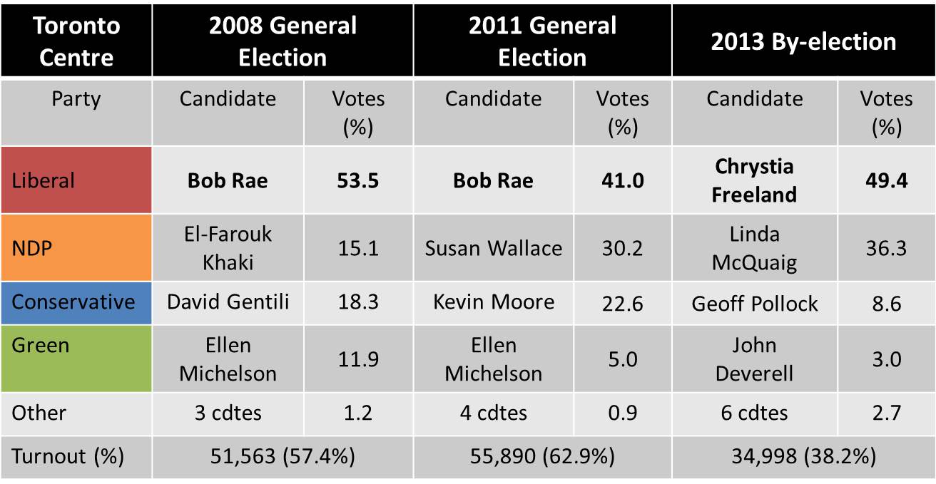
    Toronto Centre 2008-2013 Toronto Centre election results, 2008-2013

    In Toronto Centre, the NDP kept gaining support since the 2008 election, yet the Liberals held on with comfortable margins in 2011 and 2013. In the 2013 by-election, triggered by Bob Rae’s retirement from electoral politics, the CPC vote share collapsed (as did voter turnout), and Linda McQuaig, the new NDP standard-bearer, more than tripled the NDP’s share of the vote in 2008.

    Trinity-Spadina 2008-2014Trinity-Spadina election results, 2008-2014

    The NDP’s Olivia Chow, elected MP in 2006, was re-elected in 2008 and 2011. But her resignation in 2014 to run for Mayor of Toronto triggered a by-election in which Toronto city councillor Adam Vaughan took the riding for the Liberals in a by-election held on June 30, in the middle of the Canada Day long weekend. Voter turnout was a miserable 31.9%.  (more…)

  • Not seeing the light on pedestrian safety

    IMG_9773

    Earlier this week, I ranted on Twitter about a poster I spotted on the TTC. The poster, showing a pedestrian crossing a downtown street, is one of a series of posters aimed at pedestrians, all with the tag “Stay Focused. Stay Safe.” They are co-produced by the TTC and the City of Toronto.

    The poster, as seen above, shows a blurry image of a pedestrian crossing the street, wearing a backpack and a dark jacket. But it shows that pedestrian crossing legally and safely at one of the safest intersections in Toronto – Yonge and Dundas. We see cars and a streetcar waiting at the light in the background. There’s nothing wrong with this picture. What part of “stay focused” does clothing come in, anyway?

    (Some of the responses to my rant were hilarious, like the woman who compared walking downtown wearing dark clothing with hiking in rural B.C. and not being prepared for cougar attacks.)

    With the new school year and with the shorter days, it isn’t a bad time to be reminding all road users about how to stay safe. Other posters remind TTC passengers to cross at designated crosswalks and to pay attention when crossing the street, rather than focusing on their smartphones. While crossing many streets midblock isn’t itself dangerous – as long as one crosses a quiet street with caution it’s usually quite safe – the advice given in the poster above bothers me. It indirectly blames pedestrians for the clothes they wear.

    Most fall and winter clothes, especially jackets, are dark – black, navy blue, dark grey, etc. Instead of blaming pedestrians, should we be blaming clothing retailers? Should we be requiring all pedestrians to wear high-visibility clothing, and be equipped with bright flashing lights? Or as David Hains pointed out in Torontoist, why aren’t cars required to be brightly coloured as to be seen better by pedestrians?

    In Spacing, fellow Walk Toronto co-founder Dylan Reid wrote about, and debunked some common myths about pedestrian collisions. The vast majority of pedestrians in Toronto – 67% – hit by motorists had the right-of-way, such as with a walk signal at a traffic light or in a marked crosswalk. Only in 19% of collisions did injured pedestrians not have the right of way. And downtown, where there is a higher volume of pedestrians, there’s a safety in numbers; it’s on busy suburban arterials where pedestrians are most at risk; speed kills.

    And as for bright-coloured clothing, it’s a great idea for joggers and runners at night, especially in rural areas. But it doesn’t necessarily prevent collisions. I was hit on Dupont Street by a careless taxi driver two years ago, even though I was riding safely in a bike lane. My bright, reflective jacket, my steady front and rear bike lights and my flashing helmet-mounted lights did not do a thing. I’ve been nearly hit over a dozen times by aggressive drivers racing through red lights or making right turns without looking for pedestrians with the right of way; I was attentive, and avoided injury in every case.

    Some factors that make pedestrians difficult to see at night include poor lighting, inattentive and/or aggressive drivers, and motorists who don’t put their headlights on at night. There’s nothing wrong with reminding all users about how to get around safely; pedestrians should always be attentive when walking in and around traffic. There’s lots that can be done to promote pedestrian safety: better infrastructure, improved lighting, lower speed limits, and so forth. Safety campaigns are a useful tool. But blaming pedestrians for their wardrobe is ridiculous and misses the point.

  • More thoughts on cycling infrastructure

    In Torontoist last week, I mapped the new and improved bike lanes proposed for 2016. There are some great new additions – more contraflow lanes in the east end and through Kensington Market allow cyclists to take direct routes along quieter residential streets. There will finally be a pilot of the long-demanded Bloor Street bikeway; at least between Shaw Street and Avenue Road. And, as I write this post, work is being completed on separated bike lanes along Adelaide and Richmond Streets east to Parliament Street. The popularity of the lanes added last year (University Avenue to Bathurst) pretty much guarantees that these new bike corridors, still officially pilots, are permanent.

    But the map below – created for the Torontoist post – shows many gaps, even with the new 2015 and 2016 additions. Note the long north-south lane in the top centre of the map. That’s Willowdale Avenue, the longest planned addition. It ends at Sheppard, just before Highway 401; there’s no easy and safe way for cyclists to cross North America’s widest and busiest auto route anywhere near where the new Willowdale bike lane ends. Freeways and railways remain nearly impenetrable barriers for pedestrians and cyclists; this prevents the true implementation of a minimum grid.

    Bike Routes - Sept17

    But even bike lanes are only good if they aren’t blocked by ignorant or ill-intended motorists. Simple barriers like knock-down bollards or curbs are helpful, but they aren’t always effective.

    Last Sunday, I cycled from my home in east Downtown Toronto to Downtown Hamilton, following the Martin Goodman Trail, Lakeshore Road, and the Hamilton Beach trail for an 84-kilometre ride. Through Oakville and Burlington, the Waterfront Trail is nearly non-existent, so I ride on Lakeshore Road itself, which has bike lanes in only a few sections. But motorists are, almost without exception, courteous and patient; it’s the one place in the suburbs where I really enjoy cycling.

    In Hamilton, after crossing the Queen Elizabeth Way on a spectacular bridge that also spans the Red Hill Creek, I again take minor streets to make my way west towards downtown, where I usually visit a favourite pub on Augusta Street before loading my bike on a GO Transit bus rack and returning to Toronto.

    6164718675_1ac3950080_o

    Hamilton, like Toronto, has started to add some great new cycling infrastructure. It has a bike share program, called SoBi Hamilton, it has great trails leading out to Brantford and Caledonia (as well as the Waterfront Trail), and some new bike lanes and cycletracks. The most impressive is Cannon Street, where a lane on a one-way arterial was transformed into a two-way separated cycletrack last year.

    14988034160_c541a52410_k

    But even green paint, knock-down bollards, and plenty of signage wasn’t enough on Sunday, when I encountered this:

    IMG_9624

    IMG_9625

    The woman in the red shirt and grey trackpants started screaming at me as I took these photos, claiming she had the right to stop here as she was moving out of the house. She threatened to call the cops on me (!) for taking photos of her stuff, saying I could be looking to steal it. (On my bike, of course.) Cyclists encountering this from the west would be forced into oncoming traffic; in any event it’s dangerous and illegal. (Taking photos of this type, on public property, certainly is not.)

    https://twitter.com/Sean_YYZ/status/645726388310396928


    There’s still a lot of ignorance out there; not by the woman with the U-Haul that I mentioned; but by at least one reaction:

    Sidewalk riding is itself illegal and dangerous (sidewalk riding cyclists are a pet peeve of mine). Happily, there were plenty of others willing to correct that user about the safety of vulnerable road users and the various laws and by-laws applicable in this case.

    But this is all a long and winding way to say that more cycling infrastructure is great. And places like Toronto and Hamilton are doing great work on that front. But the infrastructure is only as strong as its connectivity, and as long as they’re not blocked by ignorant and/or hostile motorists. Education and enforcement need to go along with the buckets of green paint, signage, and barriers now being added in our cities.