Category: Toronto

  • Mapping an accessible TTC

    IMG_3898

    Last week in Torontoist
    , I wrote about the challenges of getting around on the TTC for passengers who rely on mobility devices, such as wheelchairs. Most of us never think about this problem unless we’re directly affected by the consequences of an inadequate system, as I was after a cycling injury in 2012.

    But for TTC users with mobility disabilities (or even passengers with strollers, wheeled carts, or luggage), it’s an issue. While the bus system is (mostly) fully-accessible, the backlog in the delivery of new streetcars and the installation of elevators in subway stations leaves the system failing many of its riders. The alternative, Wheel-Trans, is also underfunded, inconvenient and useless for last-minute travel plans.

    Here’s what the subway system looks like if you require the use of elevators to navigate the system:

    accessible map - now 2015

    By 2016, only one more station  — St. Clair West  — will be equipped, by 2017, Wilson, Ossington, Coxwell, and Woodbine (and hopefully the Spadina Subway Extension to Vaughan Centre, with its six new fully-accessible stations, will open by then) will follow. But there’s not enough funding to make the entire system accessible by 2025, the deadline set by the Accessibility for Ontarians with Disabilities Act (AODA). Seventeen stations, including Islington and Warden, remain unfunded.

    The entire bus fleet is accessible, though not all bus stops are (the TTC requires a solid, concrete or asphalt place to deploy the ramp or lift, and room for the passenger to board; some suburban stops without a bus pad, or narrow urban sidewalks make loading a passenger in a wheelchair difficult). The first four low-floor streetcars are operating on Spadina Avenue, 200 more are still to be delivered. By now, the Spadina, Bathurst and Harbourfront cars were to have been fully-equipped with the new trams.

    In the meantime, the few bus routes that operate in the central core don’t have many accessible connections; east-west travel is particularly difficult. For example, the 47 Lansdowne bus is inaccessible from either subway station it services (Lansdowne and Yorkdale), and offers no barrier-free transfers south of Dupont Street. The map below shows this problem:

    TTC - Downtown v3 Crop

    Elevators at Ossington would connect the subway with three accessible bus routes, including the 94 Wellesley, a useful east-west alternative. (The 94 serves four subway stations and enters three of them, not one is equipped with elevators.) Meanwhile, both Toronto Western and St. Joseph’s Hospitals are isolated from the accessible transit network.

  • Mapping the City’s Bike Network Gaps

    Bike-Routes-WO-GapsToronto’s Bikeway Network, as of January, 2015

    Over at Torontoist, I posted a short article about the gaps in Toronto’s cycling infrastructure. You can read it here. What follows is a quick summary and some more thoughts (and another map, showing the bikeway network without the sharrows and signed routes without bike infrastructure).

    Toronto’s bikeway network is composed of multi-use paths (off road trails in parks and ravines, shared with pedestrians), cycle tracks (separated bike lanes like those on Sherbourne), bike lanes and contra-flow bike lanes (painted bike lanes without separation; I don’t consider the flex-posts on Adelaide, Richmond and Wellesley to be proper separations — see this Metro Toronto article about a garbage truck entering the bike lane and destroying these flimsy plastic markers). The city also considers other signed bike routes (usually quiet residential and collector streets without heavy traffic) and sharrows to be part of its bikeway network, but I don’t.

    Bike Routes - WO Gaps, sharrowsToronto’s Bikeway Network, as of January, 2015, with the sharrows and signed routes removed

    When the sharrows and signed routes are eliminated, Toronto’s bikeway network looks very thin, especially outside the downtown core. Furthermore, most multi-use trails (shown in green) are not cleared in the winter (the Martin Goodman Trail the only exception) and many are unlit; they are not the safest options for women or vulnerable users.

    Below, I show some of the gaps in the existing network; where bike lanes and multi-use trails should be connected to create at least a complete network of bike-friendly routes across the city. Several circle routes are slowly coming together (via the Humber, Don, Rouge, Highland Creek and east-west hydro corridors) but there are many gaps that need to be closed to complete these circuits. The Waterfront trail is a disconnected labyrinth in Scarborough; I’d like to see a new multi-use trail beneath the beautiful Scarborough Bluffs to connect the trail to the parks below otherwise isolated and inaccessible without a car.

    The gaps in the existing bikeway network show the shortcomings in cycling infrastructure to support a minimum grid of safe bike routes in the suburbs, which would be mostly built on city streets, not in ravines or hydro corridors. Note that there are only three designated places to cross Highway 401, which is a much greater barrier to more Torontonians than the Gardiner Expressway is downtown.

    For his part, during the 2014 campaign John Tory said that he would support bike lanes where it was “sensible.” But he did not define what that meant or provide a timeline for specific goals. Given the number of bike-unfriendly councillors returned to city hall; one of whom is now John Tory’s deputy mayor, I don’t have too much confidence in seeing much more than a few downtown projects and more multi-use trails constructed in the next four years.

    Bike-Routes-Gaps
    Some of the many gaps in the existing bikeway network

  • The genesis of Mayor John Tory’s SmartTrack

    I was recently browsing Urban Toronto‘s forums (a great resource if you’re interested in keeping up with construction updates and development proposals here in Toronto), when I came across a post written by “AlvinofDiaspar” in a thread discussing SmartTrack.

    Alvin’s post linked to an interesting report written by the Strategic Regional Research Alliance, a consulting group based in Toronto that I had never heard of until recently. The report, entitled “The Strategic Case for the Regional Relief Line,” was published in October 2013, just before the mayoral race began for the 2014 election.

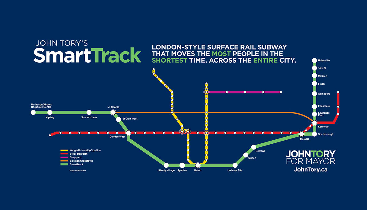
    John Tory unveiled his “SmartTrack” plan, promising a “London-Style surface rail subway” (whatever that meant), on May 26, 2014. The transit service, using frequent, electric multiple unit trains (like those used for commuter/regional transport in many European cities) would mostly follow existing railway corridors from Markham to Mississauga, via Union Station.

    On the east end, the route would follow GO Transit’s Stouffville Line from Union Station as far as Unionville Station, making more frequent stops, serving the Unilever plant (which will be replaced by a massive commercial/office redevelopment by First Gulf, first announced in 2012), as well as additional stops at Queen St East, Gerrard/Carlaw, Lawrence East, Ellesmere, Finch and 14th Avenue, in addition to existing GO Transit stops at Danforth/Main, Scarborough Junction, Kennedy/Eglinton, Agincourt (Sheppard), Milliken (Steeles) and Unionville.

    To the west, the line would follow GO’s Kitchener Line from Union Station as far as Mount Dennis (Eglinton Avenue, near the western terminus of phase one of the Eglinton-Crosstown LRT), with stops at Spadina, Liberty Village, the existing GO/UP Express station at Bloor, and at St. Clair Avenue. At Mount Dennis, the SmartTrack corridor follows a routing via Eglinton Avenue into Mississauga’s Airport Corporate Centre office district, which of course has no existing rail infrastructure to capitalize on.

    Tory promised to have SmartTrack operational in seven years, by 2021, putting other approved and/or proposed transit projects (the Downtown Relief Line, the Sheppard East and Finch West LRTs, among other plans) on the back burner.

    smarttrack_fbJohn Tory’s “SmartTrack” map

    Back in 2014, transit observers were taken aback by this new “bold” transit idea (John Tory kept using that word to describe SmartTrack), as his campaign had recently taunted Olivia Chow’s hesitancy to prioritize the Downtown Relief Line (DRL) in her transit platform. At the time, Chow, the presumed front runner in the mayoral race in April 2014, promised to increase TTC bus service and build the Scarborough LRT while planning for the DRL continued.

    The DRL is a long-proposed subway line under review by the City of Toronto and by Metrolinx that would connect downtown Toronto to the Bloor-Danforth Line east of the Don River, thus relieving the the Bloor-Yonge subway interchange from overcrowding, while offering improved transit access to east end Toronto, and addressing overcrowding on Yonge subway trains. Further extensions to the north, towards Thorncliffe Park, Flemingdon Park and Don Mills, would re-direct many current and potential transit riders from the Yonge Subway, allowing for an extension of that line from Finch to Richmond Hill.

    But to some degree, Tory’s promise of frequent, regional electric rail on GO’s corridors dovetailed with provincial plans for electrification of part of GO’s services and the Airport Rail Line (now branded as the Union Pearson Express). Improved services on GO’s corridors, if paired with fare integration with local transit (GO’s fares are very expensive for short trips), would provide useful rapid transit to many areas not served by the subway, and could provide some relief to the existing subway network. John Tory was endorsed by many provincial cabinet ministers; it appeared that he had the support of the Liberal government itself, though Premier Kathleen Wynne never endorsed any mayoral candidate directly.

    The only hint of this SRRA report that I could find in the mainstream media was in an interesting article written by Tess Kalinowski, the transportation reporter at the Toronto Star after Tory’s win on October 27, 2014. In an article published on November 17, entitled “The evolution of SmartTrack,” a report entitled “The Business Case for the Regional Relief Line” was mentioned. Also mentioned in the article was John Duffy, a political strategist who worked on the provincial Liberal leadership campaign of former transportation minister (now environmental minister) Glen Murray, and had ties to Wynne’s leadership and election campaigns. Kalinowski wrote that Duffy also was acquainted with Iain Dobson, a property developer and Metrolinx board member. Other people involved in putting SmartTrack together and mentioned in the article were the Canadian Urban Institute’s Glenn Miller (who is listed as a SRRA contact on its website, as is Iain Dobson, a real estate executive and Metrolinx board member), former Toronto chief planner Paul Bedford and businesswoman and urban expert Anne Golden.

    Transit advocate and friend Steve Munro picked up on this report before I had – you can read his posts which are more detailed and far better than my short analysis in this post:

    Munro: The Dubious Planning Behind SmartTrack Part I Part II Part III

    It’s unfortunate that John Tory decided to make this concept the centrepiece of his transit platform. Easily, the biggest flaw, mentioned by others, including Steve Munro and mayoral rival Olivia Chow, is the Eglinton section between Mount Dennis and the Airport Corporate Centre. The corridor already had a proposed rail transit project, the western leg of the Eglinton-Crosstown LRT line, a project first proposed in 2007 as part of a larger city-wide LRT plan known as Transit City, and confirmed in 2009 when the provincial government announced funding for it and three other LRT lines. (In 2010, funding was deferred for the section west of Weston Road). The once-available right-of-way that would have allowed for a surface-running heavy rail transit project was already disappearing.

    But in the SRRA-authored report, we see why Tory went along with the problematic Eglinton routing, rather than having SmartTrack continuing along the GO Kitchener/UP Express corridor towards the transit desert of northwest Toronto. It was part of a larger plan to connect suburban office parks to Downtown Toronto.

    The Regional Relief Line, as envisioned by the SRRA, would have included a third phase, from the Airport Corporate Centre to Meadowvale Business Park, another large, although sprawling, employment centre near Highway 401 and Mississauga Road. The “Phase Three” of this proposed regional rail route would follow Highway 401 on a new alignment.

    srra map
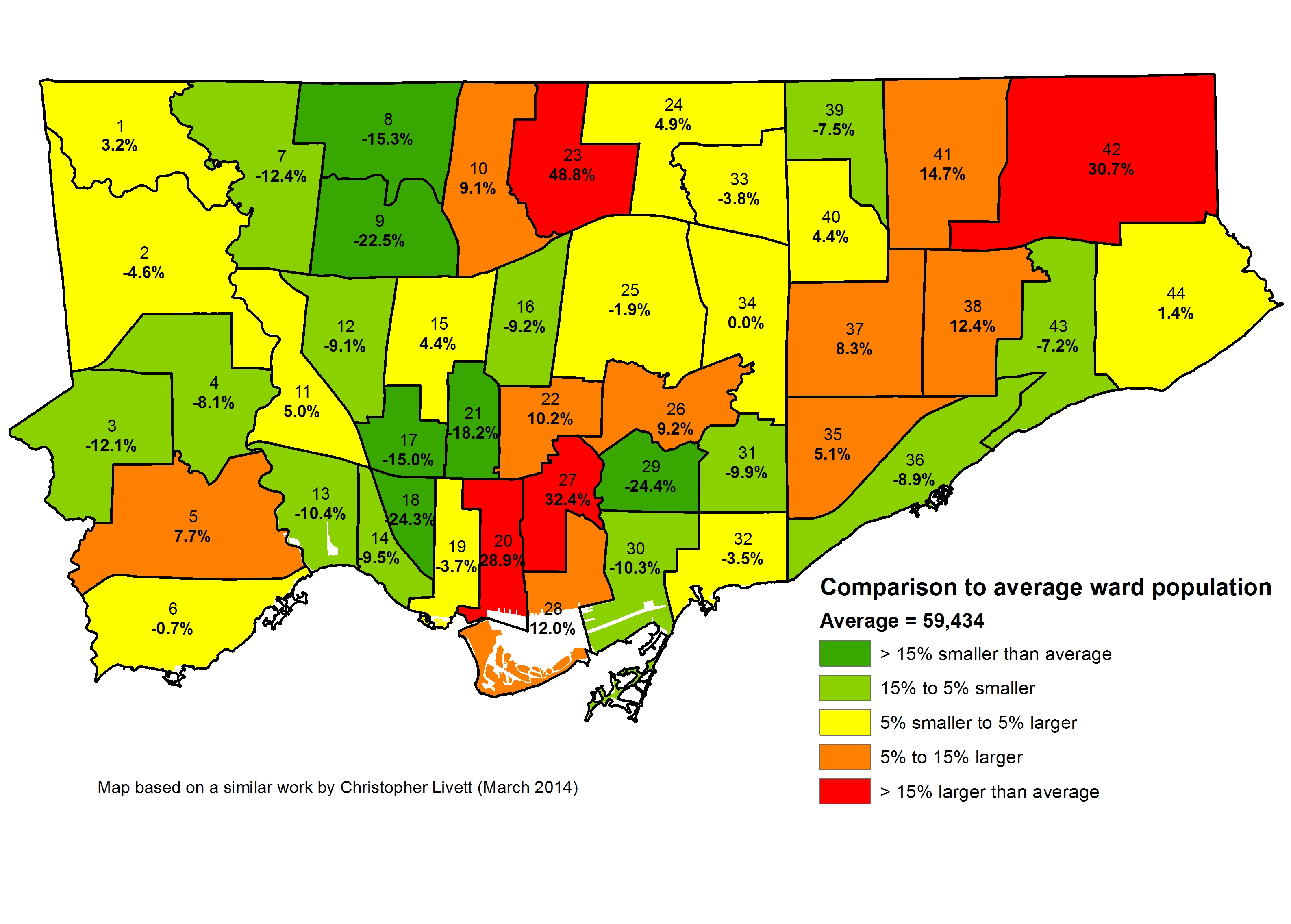
The map from the SRRA report, published on page 4. Note the use of Google Maps to create the map.

    The SRRA planning exercise appears to be one where well-educated planning experts were engaged in a game of “connect the dots.” Sure, the Regional Relief Line connected several major employment nodes in Markham, Toronto, and Mississauga, with the nodes in Mississauga lined up along Highway 401. But this error on page 6 of the report makes me wonder how many of the facts and assumptions the authors simply got wrong or didn’t fact-check:

    This phase will take a little longer to complete than the Markham phase because there are no tracks on the section from Mt Denis to the Airport Corporate Centre. This right of way will take longer to design and obtain approval in an EA process. It is owned by the Province and was intended to be an expressway. There is ample room for the dedicated right of way.

    In fact, the Richview Corridor, the right of way mentioned, was owned by the city, not the province, reserved in the 1960s for an expressway linking Highways 401 and 427 to the proposed Highway 400 extension, part of a much larger highway plan for Metropolitan Toronto. The 400 extension was cancelled and the at-grade Black Creek Drive was built instead; the Richview lands along Eglinton Avenue West in Etobicoke remained dormant for decades. But in 2011, the city started selling off the land for residential development, making the right of way unusable for any transportation corridor. (This did not matter in plans for the Eglinton-Crosstown LRT connection to the airport; there was still room to build a median LRT corridor along this section.) In 2013, pre-eminent local transit and planning experts should have been aware of this development and be able to identify the proper owner of this former right of way.

    It also strikes me as a little backwards looking to link auto-dependent office parks together with a new transit line, especially without a detailed origin-destination study. Shouldn’t urban planners be promoting dense urban employment clusters in areas well-served or potentially well-served by transit? Does it make sense to build expensive transit lines to serve low-density office complexes that come with large parking lots and garages, such as those in Mississauga’s Airport Corporate Centre? Or am I confused?

    In December 2014, mere weeks after Tory’s election, Council voted 42-1 to accelerate the work plan for the rail line, awarding up to $750,000 for early analysis and modelling work. The consultants awarded the funds? A group from the University of Toronto and Strategic Regional Research Associates. In February, council approved an additional $1.65-million towards studying SmartTrack, at least taking a closer look at the Eglinton West section of the corridor.

    To me, it seems just a little bit odd that Tory’s campaign advisers were awarded this contract to study a project, that until Tory’s election, wasn’t even on any transit planning maps. Steve Munro picked up on this as well, questioning whether  Iain Dobson, a member of the Metrolinx Board, has a conflict of interest due to his involvement with the SRRA and a member of the Advisory Board to the University of Toronto Transportation Research Institute. After all, Metrolinx is supposed to be the expert, disinterested provincial agency charged with evaluating and implementing various transit plans. Meanwhile, the need for a Downtown Relief Line hasn’t gone away.

    Tory and his connections in academia and the private sector have managed to change the course of Toronto’s short-term transit planning, and I can’t help but feel a bit suspicious of the behind-the-scenes planning that went into SmartTrack. This is a story very much worth following.

  • Mapping Which Neighbourhoods Could Be Most Affected by TDSB School Closures

    Last week the Toronto District School Board released a much-anticipated list of schools under review for closure as the beleaguered board looks to reduce expenses and raise funds for capital projects.

    Over at Torontoist, I take a look at which neighbourhoods are most affected by this review, and discuss the impacts that school closures might have. Please leave comments in that thread.

  • Mapping the 2014 Toronto election: Wards 33 and 34, Don Valley East

    With my vacation over, and back in Toronto, it’s about time to finish posting maps of the poll-by-poll results of the 2014 Toronto municipal election. In this post, I take a quick look at Wards 33 and 34, Don Valley East.

    Ward 33, in North York’s northeastern corner, is represented by centre-left veteran councillor Shelley Carroll. Ward 33 lies between Finch Avenue and Highway 401; Fairview Mall and Don Mills Station on the Sheppard subway line are close to its geographic centre. Ward 34 is represented by conservative Councillor Denzil Minnan-Wong, a municipal politician first elected in 1994 to North York City Council. Doug Ford came in first place in Ward 33, while John Tory came first in Ward 34. In both wards, Olivia Chow came in a distant third.

    Ward 33

    In Ward 33, Doug Ford won a plurality of the votes (39.4%), but by a very small margin; only 226 votes separated Ford and John Tory (who took 38.1% of the vote) in that ward. As in nearly all suburban wards, Olivia Chow came in a distant third race, netting only 19.3% of the vote there. Tory came first in most polls on the west side of the ward, closer to Yonge Street (Tory came in a comfortable first place in neighbouring Ward 24), while Ford did better in polls to the east, closer to Victoria Park Avenue and Scarborough. Condos, such as polls 008, 036, 038, and 042, picked Tory, while rental highrises went for Ford, as did single-family housing tracts east of Highway 404. Ford’s support for extending the Sheppard Subway (a money pit in this author’s opinion) was likely one factor that explains the geographic split.

    Shelley Carroll, a talented centre-left councillor and Mayor David Miller’s budget chief, was easily re-elected with 60.5% of the vote, winning all but one poll. Her nearest competitor, Divya Nayak, took 21.9% of the vote, and won only one poll, 036, a high-rise rental tower on the Don Mills “Peanut.”

    2014 Election - WARD 33 Mayor
    Poll results of the mayoral race in Ward 33

    2014 Election - WARD 33 Cllr
    Poll results of the council race in Ward 33

    (more…)

  • Does Scarborough need a subway extension? (No, it doesn’t.)

    Scarborough - 2014Rail transit routes in Scarborough, 2014

    The Scarborough Rapid Transit (SRT) line, opened in 1985, is in dire need of replacement. The SRT was planned as a grade-separated LRT route (here what it would have looked like), but the province pushed a new automated light metro ICTS technology. ICTS was developed by the Urban Transportation Development Corporation, then owned by the provincial government (UTDC’s technologies are now owned by Bombardier). ICTS has proven to be successful elsewhere, particularly for Vancouver’s SkyTrain, but not so much in Toronto.

    The city and province originally agreed to replace the ageing SRT with an extended LRT line, which would have been fully grade-separated. It would provide a rapid, high-quality transit route similar to LRT networks in Calgary or San Diego. Repairs to the existing line and new ICTS rail cars would have been expensive and difficult. For example, a tight tunnel between Ellesmere and Midland Stations would require complete reconstruction to fit the larger cars Bombardier still produces for Vancouver.

    In 2010 Rob Ford got elected on a promise of building “subways, subways, subways,” and with the province, had the fully funded, shovel-ready LRT conversion and expansion put on hold. Queen’s Park was wary of Ford’s support in those early years, and the Liberal government afraid of losing seats in Scarborough to the Conservatives. Interestingly, left-leaning councillor Glenn De Baeremaeker was one of the most vocal champions of the subway.

    The alignment for the Bloor-Danforth subway extension from Kennedy Station, which has not yet been decided, would probably be routed via Eglinton Avenue, Danforth Road, and McCowan Road, with stops at McCowan and Lawrence, McCowan and Ellesmere (or closer to the Scarborough Town Centre Mall) alignment to Sheppard Avenue, and McCowan and Sheppard.

    Council had the opportunity in 2013 to reverse its stance, but it unfortunately voted 26-18 to pursue the subway. Paul Ainslie (my favourite councillor in Scarborough), voted for the LRT, the only councillor from that part of Toronto to do so. In return, Mayor Rob Ford robo-called Ward 43 residents, falsely accusing the Ainslie of not consulting with his constituents when he decided to back the LRT. Ford was later forced to apologize by order of the integrity commissioner.

    Ainslie has it right. Support for the subway extension, even in Scarborough, isn’t as strong as many of its politicians’ rhetoric makes it sound. Some polls even suggest that residents in Scarborough support LRT. Mayoral candidates David Soknacki (who dropped out in September) and Olivia Chow supported going back to the LRT plans, but Doug Ford and John Tory backed the subway.

    So here we are. John Tory, elected mayor of Toronto, promised to continue with plans to build the Scarborough subway extension, despite its higher cost and his commitment to SmartTrack. On the campaign trail, Tory has not come out fully supporting LRT construction on Finch West or Sheppard East, two of the three pieces of the Transit City plan that are still funded. (The Eglinton-Crosstown LRT, the only Transit City route so far underway, is being built by the province through Metrolinx.)

    (more…)

  • Mapping the 2014 Toronto election: Wards 3 and 4

    Ward 3 and Ward 4, Etobicoke Centre, were both interesting races to watch. Neither ward had an incumbent councillor running for re-election. Mayoral candidates Doug Ford and John Tory were both very competitive in each ward. Tory came first in Ward 3, while Ford came first in Ward 4; both wards showed clear geographic splits in their choice for mayor. Olivia Chow came in a very distant third in both wards. Ward 4 was interesting for another reason; though Rob and Doug Ford have taken turns representing Ward 2, they both live in Ward 4.

    The incumbent in Ward 3, Peter Leon, was a caretaker councillor, appointed by council in 2013. When appointed, Leon promised that he would not run for election. The incumbent in Ward 4, Gloria Lindsay Luby, a moderate councillor and a Ford family foe, did not stand for re-election in 2014.

    Ward3_Mayor
    Poll results of the mayoral race in Ward 3

    As already noted in a few suburban wards (such as Ward 10 and Ward 15), there’s a clear distinction between areas where Tory did well and where Ford was the most popular mayoral candidate.

    In Ward 3, Doug Ford did best in polls in the north and northwest part of the ward, particularly in the high-rise residential towers and townhouse complexes that line Highway 427. Wealthier neighbourhoods such as Princess-Rosethorn and Markland Wood generally voted for Tory.

    Ward4_MayorPoll results of the mayoral race in Ward 4

    The same patterns can be found in Ward 4. Polls in affluent Edenbridge-Humber Valley neighbourhood voted for John Tory by wide margins, with one notable exception: Poll 028, Rob Ford’s home poll. Interestingly, mayoral candidate Doug Ford lost his own poll (Poll 027), he was the only top mayoral candidate to do so. Most polls north of Eglinton Avenue voted for Doug Ford by wide margins. Condominium towers, seniors’ residences, and high-end rental buildings (including Polls 015, 019, 020, 021, 022, 038) opted for Tory, while Ford did well in other rental highrises (such as Polls 003, 016, 023, 024, 036).

    (more…)

  • A visit to the Toronto Islands

     Ferry Ongiara returns to the city
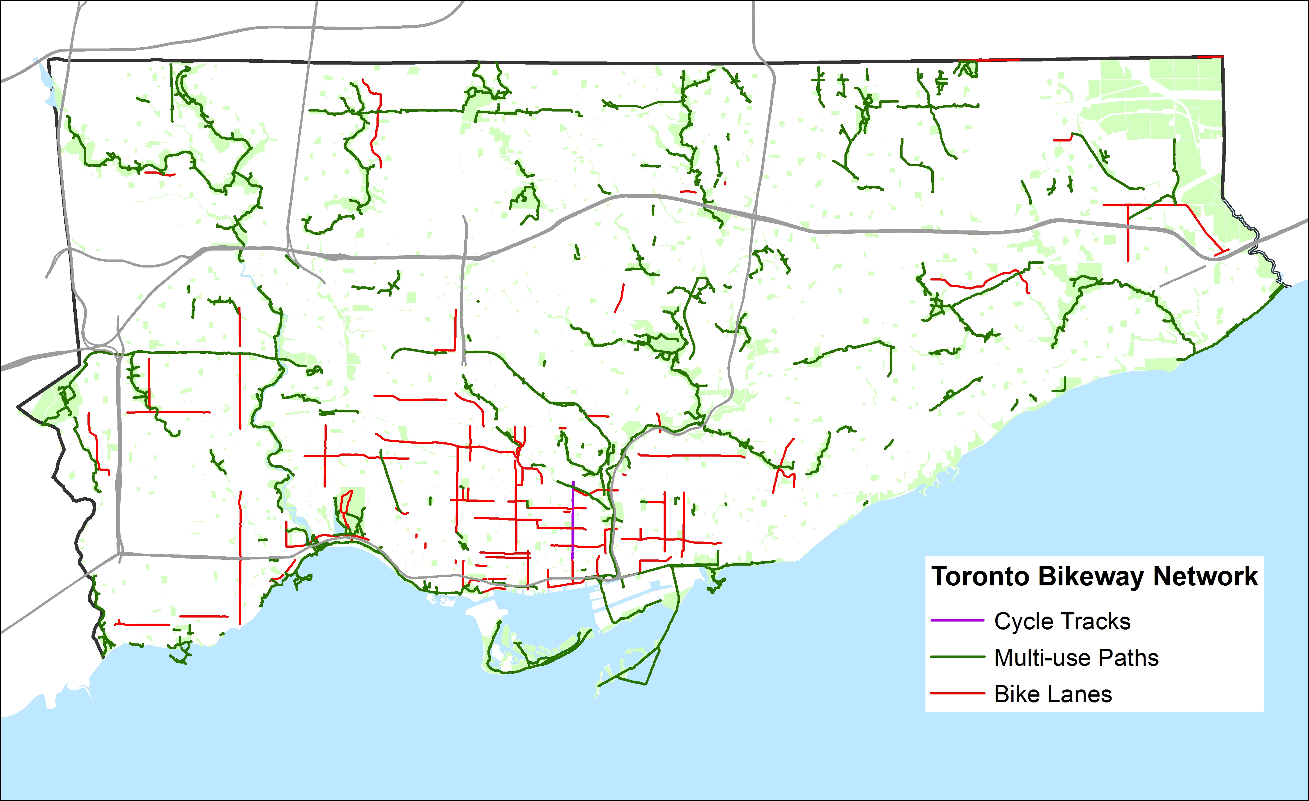
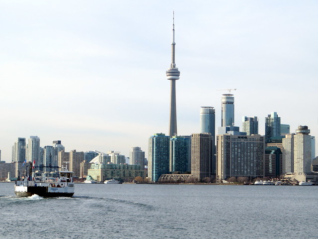
Today, December 7, was bright and sunny, despite a chilly high of -2 C. On a whim, I decided to explore the Toronto Islands during the off-season. It was well worth it.

    After Thanksgiving weekend, the Toronto Island ferry schedule is reduced to a single ferry to and from Ward’s Island operating on a rather irregular schedule. Sometimes, the service is every 30 minutes, even on Sundays (it takes just under 15 minutes to get between Ward’s Island the central ferry terminal), but at other times, the single ferry runs every 45 or 60 minutes. The round trip fare is $7, or $90 for an adult monthly pass.

    The views of the downtown skyline, are the best thing about taking the ferry to the islands; the night time views are as amazing as the daytime postcard views. During the off season, there are no crowds, no waits, no hassles. The pen-like holding area of the recently re-named Jack Layton Ferry Terminal isn’t so bad when there aren’t large crowds headed to various organized picnics or concerts at Olympic Island or the Centreville amusement park, or to one of several public beaches.

    I’d like to see a new, modern ferry terminal built that doesn’t feel like a holding pen (and which would be more fitting for a terminal named in Layton’s honour). I’m hopeful that the city will finally see this happen, as well as figure out how to better manage the long summertime ticket lines.

    The Jack Layton Memorial

    The “Jack’s got your back” statue near the entrance to the ferry terminal (more…)