Tag: Brampton

  • A tale of two university campuses

    BramptonParkingLot
    Site of Brampton’s new Ryerson/Sheridan campus

    Last week, the provincial government announced two new post-secondary educational campuses in Toronto’s fast-growing western suburbs, due to open in 2022. Wilfrid Laurier University will be partnering with Conestoga College on a new facility in Milton. Brampton will be getting a new Ryerson University campus in partnership with Sheridan College. Both new campuses, each receiving $90 million in provincial capital funding, will be focused on undergraduate STEAM (science, technology, engineering, arts, and mathematics) programs. Both will host up to 2,000 students once the new facilities are fully operational.

    Despite the many commonalities between the new Milton and Brampton facilities, the announced campus locations could not be any more different. Milton’s Laurier/Conestoga campus (which I previously wrote about as an example of the problems of greenfield institutions) will be located on a new greenfield site on the southwestern outskirts of the town’s built-up area, while Brampton’s Ryerson/Sheridan campus will be located in that city’s downtown core, on a site currently used for commuter parking. But since GO Transit’s free commuter parking has to go somewhere, Metrolinx has been buying up and demolishing houses and offices on a nearby downtown block.

    I compared the two new campuses for TVO

  • Brampton’s multi-use path problems

    IMG_2362-001Recreational Trail: no loitering

    Brampton, my hometown, has a great network of parks, many of which are connected by multi use paths that follow local waterways like the West Humber River and Etobicoke Creek. In suburban neighbourhoods where curvilinear street networks and cul-de-sacs predominate, these paths are necessary as shortcuts for pedestrians and cyclists, and for anyone looking to take a stroll away from the busy arterial roads.

    But these multi-use paths, called “recreational trails” by the City of Brampton, do not properly accommodate all users. And where these paths meet major streets, users must either detour far out of their way to a designated crossing, or attempt to cross a busy roadway. Where Toronto and even other suburban municipalities can get this right, Brampton consistently gets it wrong.

    IMG_2361-001Entrance to Addington Park at Balmoral Drive, Brampton. Part of the Don Doan Trail.

    The first problem Brampton has is the consistent lack of curb cuts where a park path meets any roadway, be it a residential side street or a busier road. Curb cuts are necessary not just for cyclists, but for pedestrians with strollers, or anyone using a mobility device such as a walker or wheelchair. In many cases, a nearby private driveway or a nearby intersection can provide the necessary curb cut, but this is not always the case. Perhaps the reason not to provide the cut is to discourage cyclists or children with wheeled toys crossing without stopping and dismounting, or preventing motor vehicles from entering the path. But it instead encourages cyclists to ride on the sidewalk instead, where most cyclists shouldn’t be, and makes it more difficult for parents with young children, or pedestrians with disabilities from using the paths.
    (more…)

  • What’s going on in Downtown Brampton?

    IMG_6139-0015 Railroad Street, on the City of Brampton’s heritage registrar, is one of several houses recently boarded up in Downtown Brampton

    Update April 19, 2018: the location for Ryerson’s new Brampton campus was announced this morning. The 2000-student campus, which will be a partnership between Ryerson University and Sheridan College, will be built at the corner of Mill and Church Streets, on the GO Transit parking lot. This explains Metrolinx’s (GO Transit’s parent agency) purchase and demolition of properties south of the rail corridor, on Nelson, George, Railroad, and Elizabeth Streets, which I wrote about below.

    While it remains unfortunate that surface parking will replace housing and offices, at least in the short-to-medium term, at least we now know what’s going on in Downtown Brampton. The downtown campus site, with excellent transit links, is the right location.


    Nearly two years ago, I wrote about how Metrolinx, the Province of Ontario’s regional transportation authority, had purchased several houses and two office buildings in Downtown Brampton. The intention at the time was to build a new surface lot to accommodate GO Transit commuters, a symptom of the commuter transit system’s dependence on providing parking.

    Metrolinx is responsible for GO Transit, the UP Express airport rail link, the Presto farecard, and planning and constructing transit infrastructure in the Greater Toronto and Hamilton Area.

    Since my 2016 blog post, three dwellings — 28A and 28B Nelson Street West, a semi-detached house, and 42 Elizabeth Street North — were demolished, but there was little other visible change until this month. Now eight more houses — on Elizabeth Street and Railroad Street have been boarded up and their electricity disconnected, including at least one rooming house that was occupied until very recently. The two office buildings — 29 and 37 George Street — are also emptying out.

    Four of these properties — 30 Nelson Street West, 46 and 50 Elizabeth Street North, and 5 Railroad Street — are listed by the City of Brampton as containing heritage resources.

    IMG_6153-001Offices at 37 George Street are moving out

    So what exactly is going on? Why has Metrolinx purchased twelve homes and two offices in Downtown Brampton? Is it for a surface parking lot as previously reported in 2016? Or does this have to do with recent plans for a new Brampton campus of Ryerson University?

    The City of Brampton has been assembling land and buildings nearby, including 8 Nelson Street West, a six-storey office building above the downtown bus terminal. The city also owns the old Loblaws store on the southeast corner of George and Nelson Street. As Bramptonist‘s Divyesh Mistry found, Metrolinx noted “…continued collaboration between Metrolinx staff […] with the City of Brampton and Ryerson University on the Brampton Station redevelopment.”

    IMG_6148-001
    Houses on Elizabeth Street North recently vacated and boarded up. 

    If this land assembly is, in fact, to support a yet unannounced Ryerson University campus site on this block or on the existing Brampton GO Station parking lot, then this is on the whole very good news, though I remain concerned about the loss of downtown housing, particularly rooming houses and affordable apartments that some of older homes in the area have been divided into. A downtown campus with excellent transit links — GO Transit and several Brampton Transit bus routes — makes more sense than Milton’s plans for a greenfield campus for Wilfrid Laurier University distant from GO Transit’s bus and rail lines.

    IMG_6149-00146 Elizabeth Street North, a rooming house with heritage status, is now boarded up, with the electricity disconnected. 

    Unlike a competing university campus site near Etobicoke Creek backed by New Brampton (a politically influential group of local business and landowners who also opposed the Hurontario-Main LRT route), the GO Station and the Nelson/Railroad/Elizabeth Street buildings are outside the historical floodplain and can be built quicker.

    If the existing GO Transit parking lot were to be used for Ryerson’s Brampton campus, then an alternative parking site would be required — hence the recent purchase and the demolition of these homes and offices. The construction of a new surface lot in an designated “anchor hub” — where rapid transit lines meet and urban intensification is encouraged — would be most unfortunate, but I hope that it will not be a long-term solution. On the other hand, a new university campus is exactly the type of land use that should be located at an “anchor hub.”

    So far, local officials have kept very quiet about the land assembly on the block surrounded by George, Nelson, Elizabeth and Railroad Streets, perhaps waiting for approvals from the province and Ryerson University before making a public announcement. But with residents and office tenants displaced and houses boarded up suddenly, confirmation of these plans should come soon.

  • Brampton Transit’s evolution from a laggard to a leader

    5010657604_d3cd2c355a_o.jpg
    The introduction of Brampton Transit’s Zum service in 2010, serving York University, was a major turning point for the suburban transit agency

    For TVO this week, I discuss Brampton Transit’s impressive ridership growth. In the last five years, Brampton Transit has bucked the trend of stagnant ridership numbers encountered elsewhere in the Greater Toronto Area and North America in general. I argue that Brampton’s success in improving transit ridership comes from sustained investment over many years, the move to a grid-based route structure, and the introduction of Züm, a basic network of semi-frequent, limited-stop bus routes, many of which extend outside of Brampton’s boundaries.


    I grew up in Brampton, and I have collected maps since kindergarten; my collection includes several old Brampton Transit maps. These maps help to illustrate the progress made since the 1980s, when the level of service provided was quite basic.

    Brampton Transit began operations in 1976 after the old Town of Brampton’s local bus service was amalgamated with the dial-a-bus service operated in Bramalea. (Brampton amalgamated with most of Chinguacousy Township in 1974, including Bramalea.) In 1980, Brampton Transit operated 14 routes, serving a community of just under 150,000 people. Buses operated no later than 9:00 or 10:00 PM, Mondays through Saturdays, and many routes operated with long, meandering loops. Apart from GO Transit, there were no connections to nearby communities.

    Brampton Transit - December 1980 front
    December 1980 Brampton Transit map

    By 1988, service was offered on Steeles Avenue to Humberline Drive in Etobicoke, where connections could be made to TTC buses on the 96 Wilson and 73 Royal York buses, but didn’t continue east to Humber College. Brampton Transit Route 14 Torbram served Westwood Mall in Mississauga, and connections to Mississauga Transit could be made at Shoppers World. But still, service levels were poor — you were lucky to get a bus every 30 minutes outside of rush hours. Permanent Sunday service wouldn’t come for another ten years. Notable are the four lettered bus routes — A, B, C, and D — that made direct connections to the four weekday GO train round trips to and from Toronto.

    Brampton Transit’s maps of the era are also historically notable because of their advertising: only one of the Burger King locations shown on the 1988 map still exists. Other restaurants advertised — the Old Beef Market, O’Henry’s, and Queen’s Pizzeria — are no longer in business.

    Brampton Transit - 1988
    September 1988 Brampton Transit Map


    Brampton Transit Maps published in the 1990s and early 2000s were printed on newsprint, and used only a two-colour scheme: blue for regular routes, and orange for rush-hour routes. Service to new subdivisions was often provided by way of long one-way loops, which is an inexpensive way of serving new areas, but are inconvenient and slow for potential riders.

    Notable in the 2001 map below is Route 77, launched in the 1990s as a joint Brampton Transit/Vaughan Transit route between Bramalea City Centre and Finch Station along Highway 7. Route 77 was a very slow way to get to the subway from Brampton, but it operated until Züm began service in 2010. In 2001, bus service on 11 Steeles was finally extended to Humber College’s main campus.

    Brampton Transit, 2002
    September 2001 Brampton Transit map

    2005 marked an important turning point for Brampton Transit, as it introduced a grid-based route system on major arterials. Route 14 Torbram, for example, no longer served Bramalea City Centre, but continued north, providing a core north-south route; many other routes were straightened, including Route 2 Main north of Downtown. Changes since May 2005 saw service frequencies improved, more local routes added, and improved connections.

    Brampton Transit - 2005 front
    May 2005 Brampton Transit map

    The current system map, dated September 2017, can be found on Brampton Transit’s website.

  • Some answered questions about Toronto’s next subway extension (updated)

    36354175911_632dc72411_o.jpgYork University Station, August 2017

    Updated October 10, 2017

    Ten months ago, I wrote about some of the unanswered questions about the Toronto Transit Commission’s Line 1 subway extension to York University and Vaughan. At the time, I was concerned about fare integration once the subway opened, especially if suburban GO, YRT, or Brampton Transit passengers headed to York University were required to make new transfers to the subway at Vaughan Centre or Highway 407 Stations.

    We now know the day the six new subway stations will open: Sunday, December 17, 2017. We also know how the TTC, York Region Transit, and Brampton Transit will serve the new extension and York University. And today, we also have some indication of how GO Transit passengers will be affected by the changes.

    YRT Subway Map.jpg
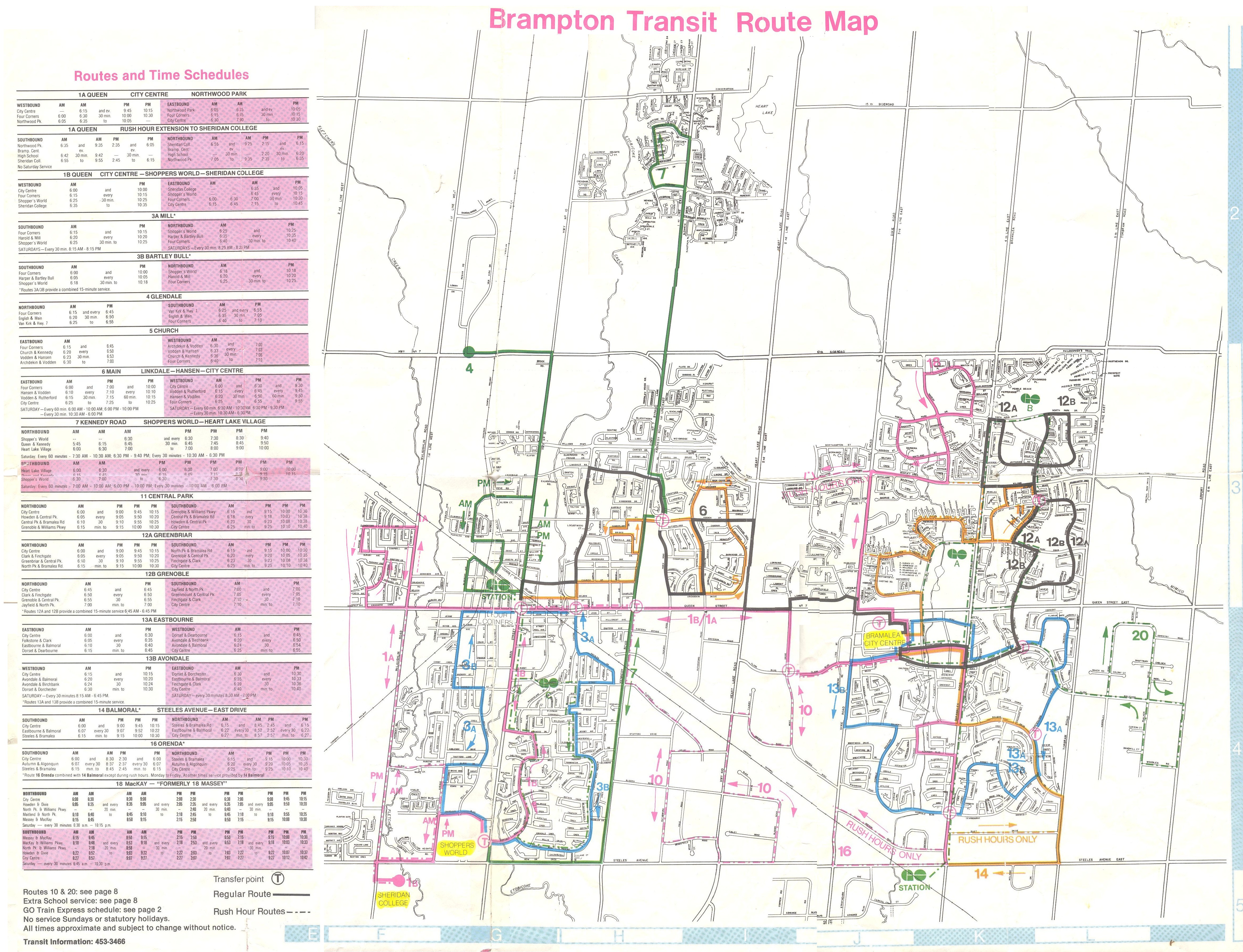
    How YRT and Brampton Transit will serve the Line 1 subway extension
    (from the YRT website)

    On Friday, Premier Kathleen Wynne and Transportation Minister Stephen Del Duca will announce a new co-fare between the TTC and Metrolinx services (GO Transit and Union Pearson Express), to take effect in January 2018. (The Star previously reported that the fare change will take place as soon as the subway extension opens.)

    Transfers from GO Transit or UPX to the TTC will cost $1.50 for passengers using Presto cards, a 50% reduction from the full adult fare of $3.00. Passengers transferring from the TTC to GO or UPX will get a $1.50 fare discount. It is expected that the new co-fare subsidies will cost the provincial government $18 million a year. The fare discount will not apply to passengers using fare media other than Presto cards, including TTC tokens, Metropasses, or paper one-way tickets or day passes.

    These are similar to the co-fares offered between GO Transit and transit agencies outside the City of Toronto, including MiWay, York Region Transit, Brampton Transit, and Hamilton Street Railway. However, these co-fares are generally more generous — ranging from $0.60 in Hamilton to $1.00 in York Region.

    There was no news on reducing the fare penalty for transferring between the TTC and connecting local bus systems such as York Region Transit and MiWay.

    For many commuters, the new TTC co-fare is great news, and it represents a good first step towards proper fare integration. It helps to make GO Transit more useful for trips within the City of Toronto, and it helps suburban commuters who use the TTC for part of their trip, such as University of Toronto students, who are located too far a walk to Union Station.

    (John Tory is also claiming a victory, calling it “a step in the right direction” for his SmartTrack proposal. At this point, “SmartTrack” is little more than a GO/TTC fare agreement and a few new proposed GO stations.)

    However, this could also affect York University students as well. Previous plans for the Line 1 subway extension saw GO Transit buses serve the Highway 407 station, requiring a transfer to the subway to get to campus. York University has been long eager to remove the buses from the York Commons area, which GO and the TTC use as their campus terminals.

    York Region Transit will continue to operate many bus routes into York’s campus, on the Ian Macdonald Boulevard ring road, and Brampton Transit’s Queen Züm bus route will remain on campus. Their university-bound passengers won’t be required to transfer to the subway and pay an additional fare. But it appears, for now, that GO Transit passengers will have to make a connection, costing $1.50 each way. (This will not be the case for in the short term, see update below.) This will also apply to GO train customers on the Barrie Line who currently use York University Station, if that station closes as planned when the subway connection at Downsview Park opens.

    This will be a blow for GO Transit customers who commute to and from York University, accustomed to a one-seat ride direct to campus. But it will be an improvement for GO operations on the Highway 407 corridor, with buses no longer stuck in traffic in the Keele Street and Steeles Avenue area. It will also benefit GO Transit passengers who aren’t headed to York University. Providing good public transit is not be about giving everyone a one-seat ride.

    Despite these benefits, if GO Transit serves Highway 407 Station as planned, it will impact many passengers with a new transfer and an additional $3.00 cost per day. I’m curious what GO Transit’s messaging and final plans will be, because they have yet to communicate their new schedules and connections when the subway extension opens. Hopefully, we will learn the answers to the rest of those questions soon.


    Update: According to the CBC and Metrolinx’s Anne Marie Aikins, there are now no immediate plans to re-route GO Transit buses from York University. at least in the short term. This is a short-term solution, however, because the Highway 407 station was designed with a large terminal for GO Transit buses, and York University has been vocal about wanting the hundreds of GO and TTC buses a day out of the York Commons area.

    I don’t see this as a long-term solution, however. Hopefully Metrolinx and the TTC can figure out how to best serve York University passengers, though that should have been figured out a long time ago. After all, the subway was originally supposed to open by the end of 2015.

  • Mount Pleasant: New Urbanism that almost works

    IMG_2706-001Mount Pleasant Square, Brampton

    A few weeks ago, I visited Cathedraltown, a subdivision in north Markham built in the new urbanist style. Cathedraltown made the news thanks to a controversial metallic sculpture of a cow installed in a parkette. (Last week, Markham City Council voted to move the sculpture.)

    I came away disappointed by Cathedraltown. Despite a dense built form, and a main street lined with storefronts, it did not live up to the new urbanist promise: it was still a very car-centric subdivision, without the retail, nor the density required to make it a walkable community. The central focus is a Slovak-Catholic cathedral, recently re-opened after lengthy dispute between the development company and religious leadership. “No trespassing” signs still stand in front of the imposing church. Transit connections are poor, making a car virtually necessary to get even to nearby employment areas.

    Mount Pleasant, in Brampton, fares somewhat better, despite some similar issues to Cathedraltown. What distinguishes it though are superior transit connections, and a better-programmed central focus.


    Satellite view of Mount Pleasant via Google Maps 

    Mount Pleasant started off as a small settlement between Brampton and Georgetown, where Highway 7 and 3rd Line West (later Creditview Road) crossed the Canadian National railway line between Toronto and Guelph. For most of its existence, it was little more than a collection of houses, two churches, a motel and a service station. By the 1960s, the local trains no longer served the flag stop there, and Highway 7 — now Bovaird Drive — bypassed the hamlet on a new railway overpass in the 1960s, also severing Creditview Road.

    A few buildings — two houses and a former Presbyterian church, now a mosque — remain at the former crossroads. New subdivisions now surround the historical community.

    IMG_6725Mount Pleasant’s old Presbyterian church is now a mosque.

    Mount Pleasant GO Station opened in 2006, just as northwest Brampton was transforming from farmland to new subdivisions. The GO Station was built like any other in Toronto’ suburbs: a large parking lot, bus loop, and pick-up and drop-off area, with easy access to Bovaird Drive. But on the north side of the tracks, the City of Brampton, and the developer, Mattamy, tried something different.

    At the core, the City of Brampton built a new library branch that incorporates the dismantled Canadian Pacific Railway station that used to stand on Queen Street in Downtown Brampton. (The station was moved in 1980 to a then-rural site on Creditview Road when it was threatened by demolition by the CPR. But the station building was left to rot before heritage conservationists carefully dismantled the structure.) Behind the library is a public school. In front, there’s a public square that includes a small playground, as well as a reflecting pond that’s a skating rink in the winter.

    IMG_2709-001The Brampton Public Library incorporates the former Brampton CPR Station, rebuilt here at Mount Pleasant Village

    To the west of the square are several low-rise apartment buildings, the sort of “missing middle” housing needed in Toronto’s established urban neighbourhoods. To the east are several retail/residential blocks, the sort of mixed use buildings that are uncommon in new subdivisions. The storefronts are all mostly occupied with businesses serving the local neighbourhood, such as hair salons and spas, a convenience store, a dentist’s office, and a restaurant. To the south are entrances to the GO Station and the bus loop for GO and Brampton Transit buses.

    (more…)

  • Greenfield infrastructure: not so green

    St. Catharines site, Niagara Health System

    I recently visited two Ontario cities, St. Catharines and Orillia, to illustrate the problems of building new medical and educational institutions on isolated greenfield sites.

    Large greenfield lands have several advantages: they’re easy and inexpensive to build on, they can accommodate large parking lots, and offer room for future expansion. But by the nature of their isolation, they’re more expensive to serve with road and water infrastructure, and more difficult to connect to transit. Students, patients, and employees must travel farther, and they don’t foster economic and social connections with the local community as well.

    St. Catharines

    In 2013, a new hospital campus opened in St. Catharines, replacing two smaller, run-down hospital sites just outside of the city’s downtown core. The new Niagara Health System site offers new and improved services, such as regional cancer centre, a spacious and bright dialysis unit, and a modern mental health centre. When the site opened, it was a vast improvement over the older facilities.

    But there was one, major, drawback: the new hospital site is located on the far western edge of St. Catharines’ suburban sprawl, almost inaccessible without a car.


    Location of current and former St. Catharines hospital sites

    St. Catharines Transit re-routed a bus route (Route 1) to serve the new hospital site, but it costs the transit system nearly $400,000 a year to do so. The old General Hospital had four bus routes within walking distance to its urban location. Passengers from Thorold, Merritton, or several other neighbourhoods are required to make an additional transfer at the downtown bus terminal in order to access the new site. The distance makes taxi trips more expensive for the majority of St. Catharines residents and more difficult to get to by foot or by bike.

    (more…)
  • A better Hurontario Street – an LRT update

    IMG_0091-001.JPG
    Metrolinx light rail vehicle mock-up at Gage Park, meets a Brampton Transit Zum bus, 2013. 

    Earlier this week, I visited Brampton City Hall, where at a public open house, Metrolinx and city staff provided an update of the Hurontario Light Rail Transit project. Brampton City Hall was an ironic location for the open house; before Brampton Council voted against building the LRT up to Downtown Brampton and the GO/VIA Station, the LRT line would have stopped right here. Even with Brampton’s decision, there will be three stops in the city, so an open house for local residents to provide their feedback was still needed.

    hurontario_lrt_map_en-850x550
    The Hurontario LRT project, map via Metrolinx

    The open house was quite interesting as more design details were displayed. There`s a focus on promoting active transportation — walking and cycling — and urbanizing much of the corridor. Three lanes of motor traffic will go down to two in most places, and right turning traffic will be tamed. This will make Hurontario Street a safer and more pleasant place to be.

    Along the entire LRT corridor, Hurontario Street will feature separated bike infrastructure — for the most part, there will be separated bike lanes, with multi-use paths in a few areas, especially south of the Queensway, where Hurontario Street is narrower. Sidewalks are also wider. With only a few exceptions, cyclists will be able to ride across intersections without being required to dismount. Those exceptions are at the Queen Elizabeth Way, and at Highways 403 and 407, where Ministry of Transportation Ontario (MTO) standards at interchanges will force the “stop, dismount, wait for gap” regime; pedestrians will also still have to yield to motor traffic.

    img_8334-001
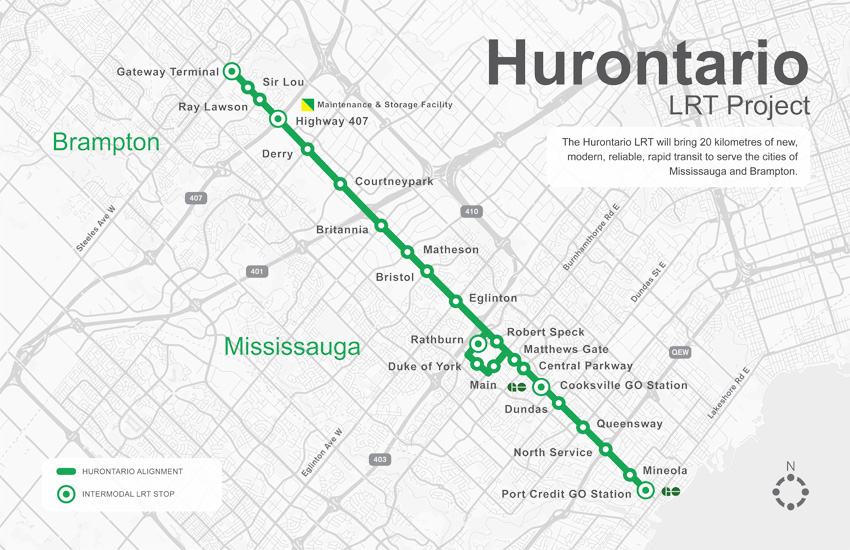
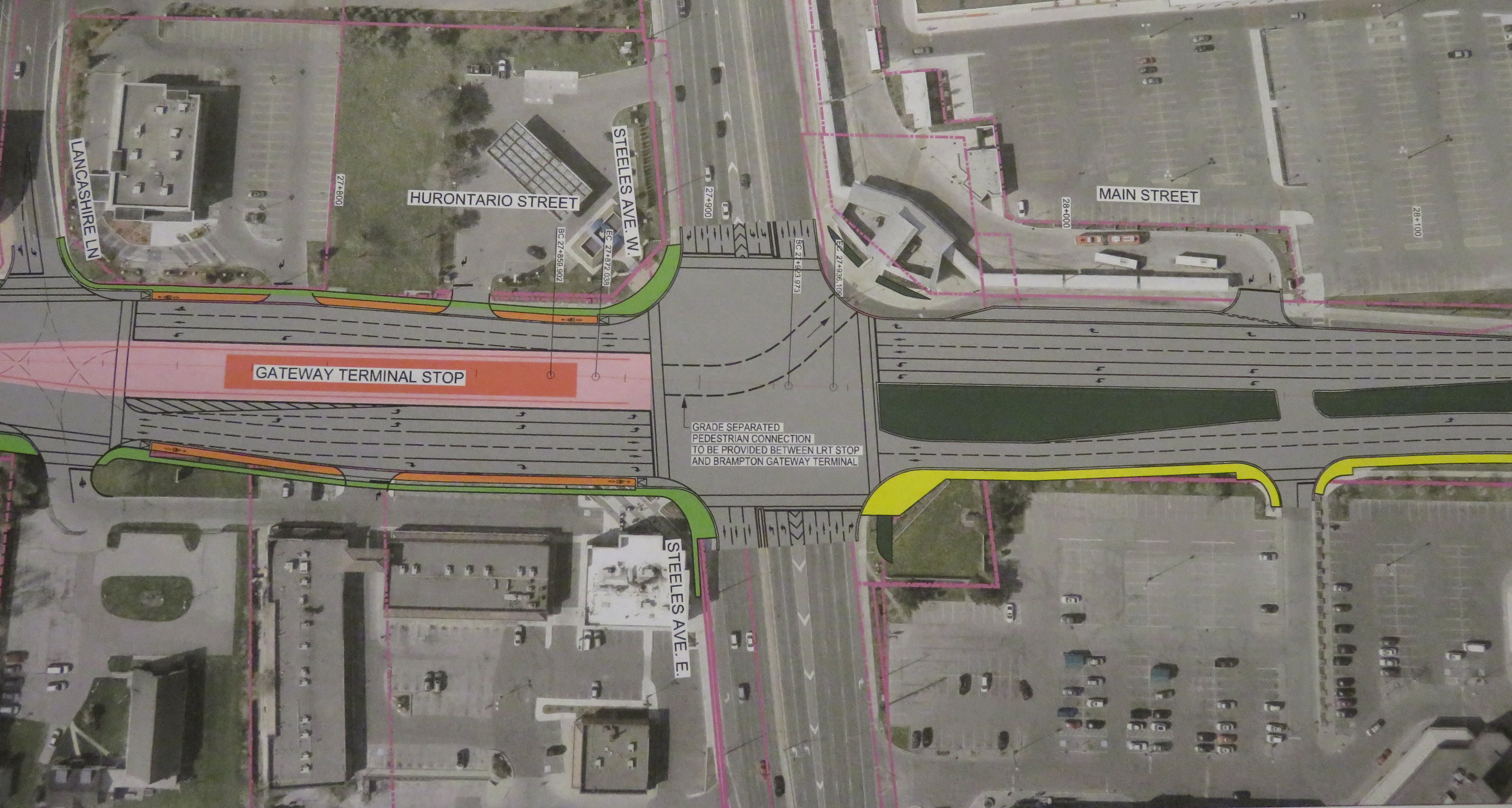
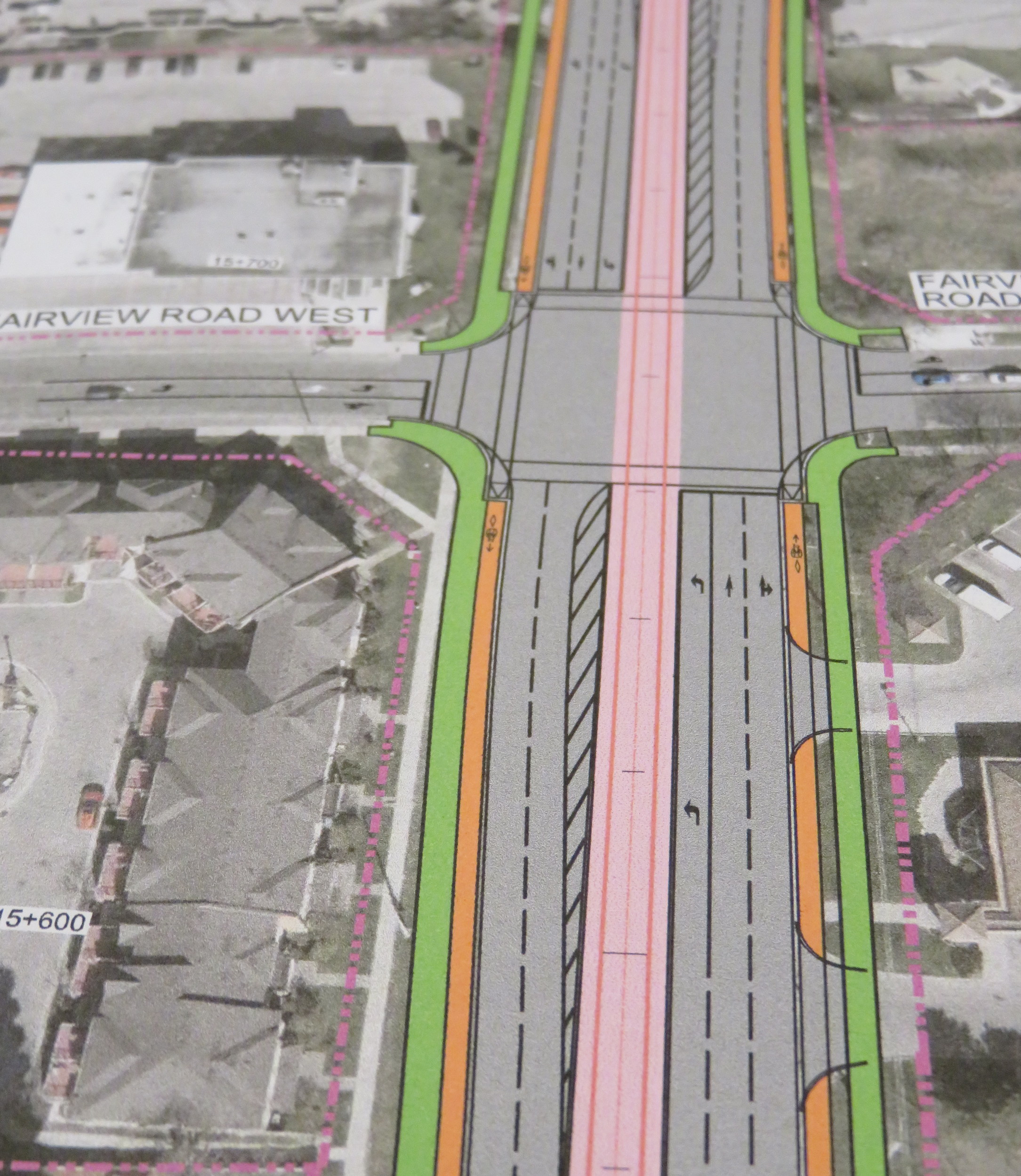
Typical cross-section once the LRT is built. The orange paths are the separated bike lanes, the green paths are sidewalks. Hurontario Street will only have two traffic lanes in each direction. 

    img_8328-001
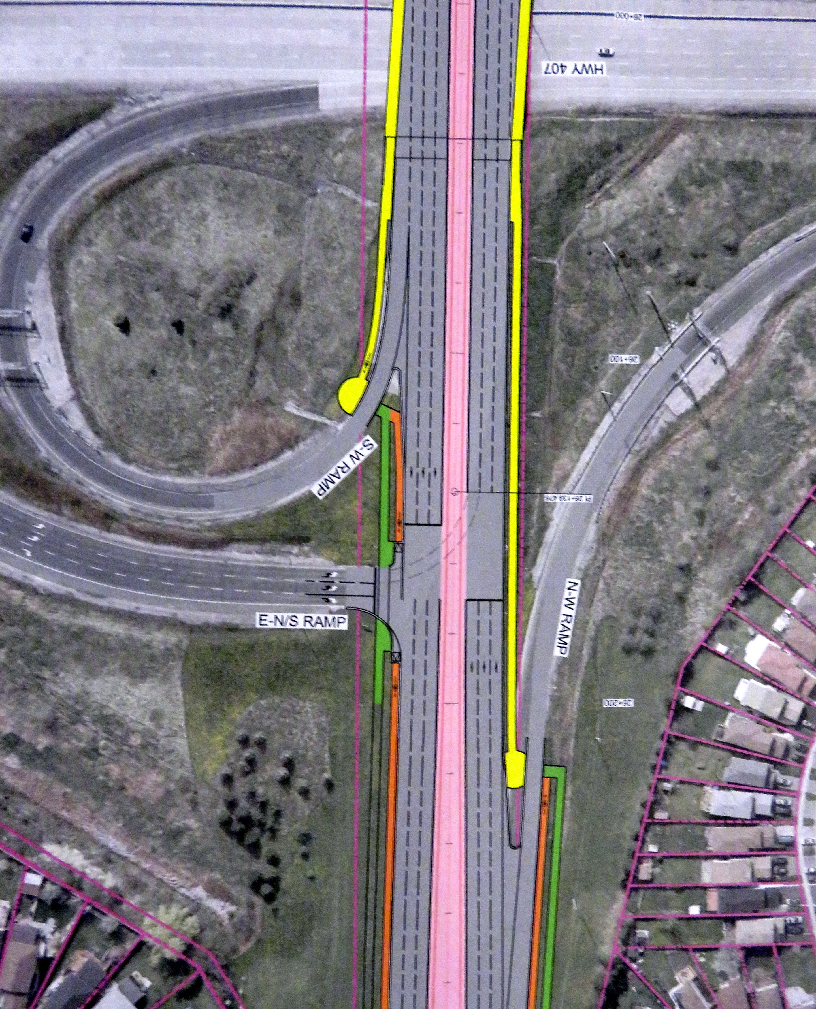
At expressways, like at Highway 407, pedestrians and cyclists still must yield to motor traffic at on-ramps. 

    In another benefit for pedestrians and cyclists, channelized right turns are eliminated along the entire route. Channelized right turns (like the one shown below) are convenient for motorists, but they increase conflicts with foot traffic and are incompatible with lower speeds and safe cycling infrastructure. Their removal also creates new room for streetscaping opportunities.

    4852433218_a9848b9973_o
    An example of a channelized right turn

    The northern terminus of the LRT, at least for now, will be at Steeles Avenue. As Brampton debates other LRT alignments (Kennedy Road and McLauglin Road are indirect alternatives to reach Downtown Brampton), the stop was moved to the south side of the intersection. This is unfortunate: the Brampton Gateway bus terminal, which opened in 2012, was designed to easily connect with the planned LRT stop on the north side of the intersection, with two short crosswalks across southbound Main Street.

    img_8331-001
    Planned LRT terminus at Steeles Avenue, including tunnel between the LRT platform and the Brampton Gateway Terminal. 

    Instead, a more expensive tunnel is required to accommodate transferring passengers between the LRT and buses. Elevators and escalators will provide direct access to the tunnel; crosswalks at Steeles Avenue and Lancashire Lane will also be accessible from the platform.

    The final contract is planned to be signed in mid-2018 and construction should begin in Fall 2018. As the City of Mississauga backs the LRT project, hopefully any change in the provincial government will not jeopardize this plan. Not only will Mississauga (and south Brampton) get a fine new transit service, it will also see a tamer, more urbanized main street.

    And maybe Brampton City Council will come to its senses and extend the transit corridor via the direct, least-expensive, Main Street alignment.

  • Rethinking Downtown Brampton’s streetscape

    IMG_8755-001
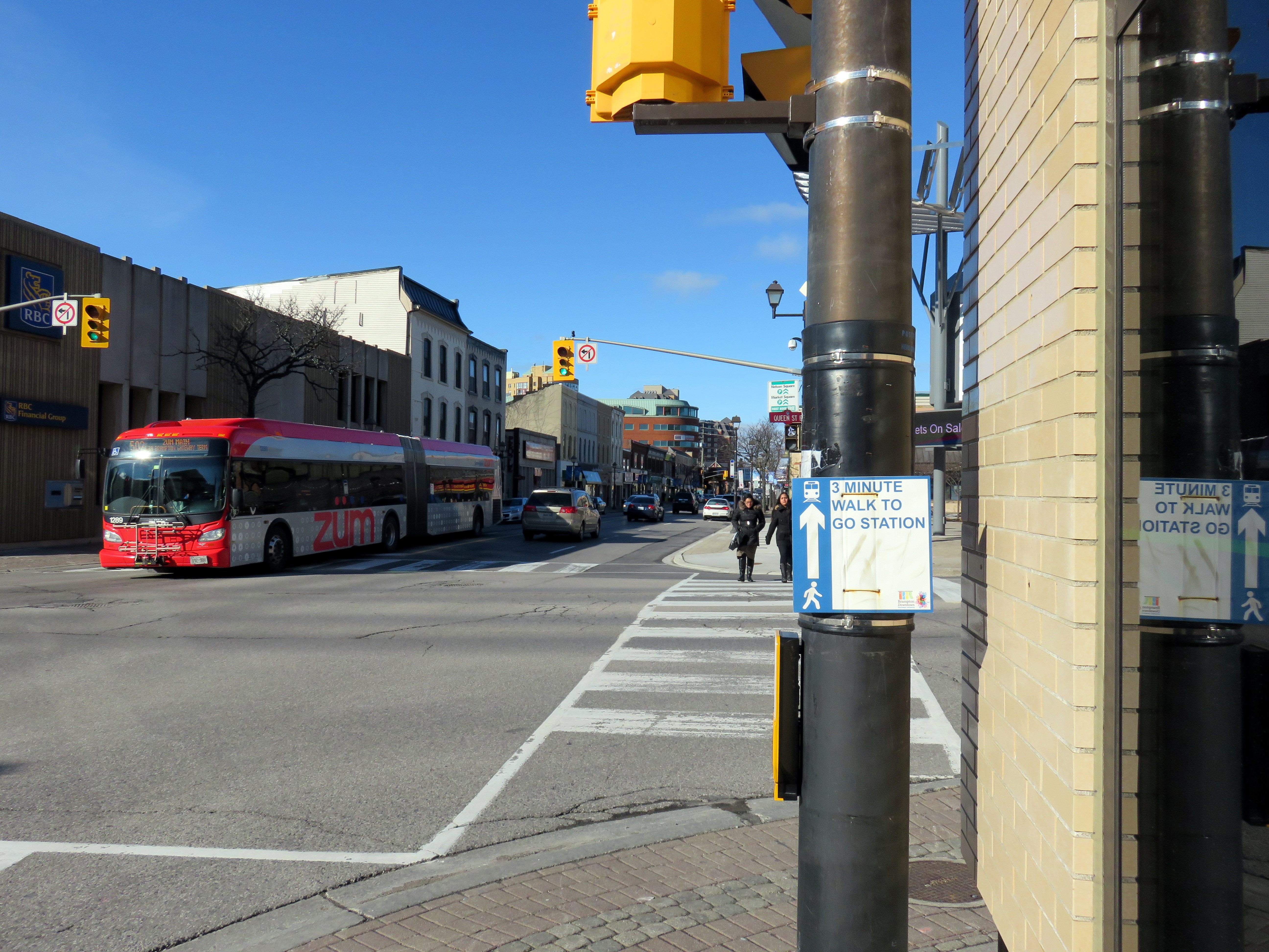
Main Street looking north at Queen Street, Downtown Brampton

    On Thursday, February 23, I went back to my hometown to check out plans for re-configuring Main and Queen Streets in Downtown Brampton. As the Region of Peel needs to replace water and wastewater infrastructure in the area, the timing is right for re-imagining what the streetscape should look like.

    The same conversations are taking place in Downtown Toronto. There there are proposals for transforming King Street to prioritize transit and pedestrians; on Yonge Street, city planners, Ryerson University, and local businesses are looking to provide more space for pedestrians and cyclists, as well as street furniture (such as benches and trees), patios, and special events. Of course, re-imagining downtown streets where cars are given priority will generate opposition, but it’s necessary in dense, urban cities were people, and not necessarily their cars, are given priority.

    Downtown Brampton has great bones; it has numerous heritage buildings, several great public spaces, and GO Transit and VIA Rail trains stop right here. The Saturday Farmers’ Market is popular, as is ice skating at Gage Park. But despite some interesting new restaurants and bars, most retail has struggled here, and even new residential development in the area is sluggish. Improving the public realm, especially wider sidewalks and more attractive streetscaping, would be a relatively inexpensive, yet symbolically important, step to making downtown a more desirable place to be.

    img_8159-001
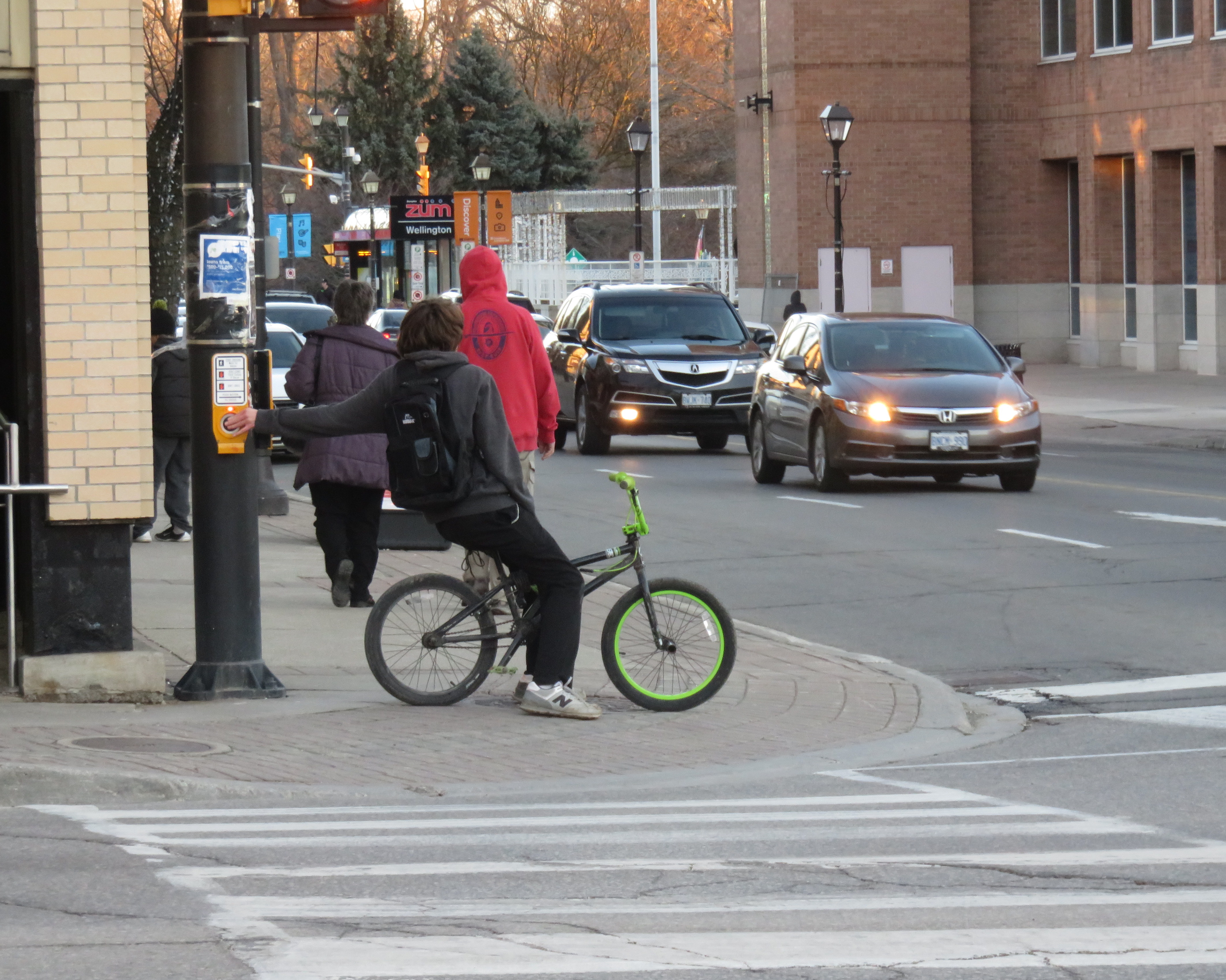
Sidewalks are narrow, and cyclists often take the sidewalks in Downtown Brampton. 

    (more…)

  • Suburban cycling infrastructure: the 416 versus the 905

    IMG_2051-001
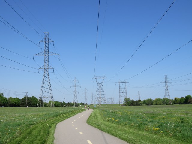
Riding along the McNicoll hydro corridor in northern Scarborough

    Earlier this summer, I took two rides from my downtown apartment to suburban locations. On one ride, I biked northeast to Agincourt, on another trip, I biked to Downtown Brampton on a route that took me past the Humber River and Etobicoke Creek. I experienced different standards for on-street and off-road cycling routes. The City of Toronto generally does better, but suburban cycling infrastructure generally depends on off-road trails, rather than on-street bike lanes and cycle tracks.

    In the urban, central part of Toronto, bike lanes and cycle tracks (separated bike lanes located along major streets) are the predominant form of cycling infrastructure. While there are some bike lanes in suburban Toronto and in other municipalities like Mississauga and Brampton, most bike routes, if they exist, are off-road multi-use trails, in ravine or hydro corridors, or alongside major roads, like sidewalks.

    Multi-use paths are pleasant to ride on, but they’re often treated as recreational trails, rather than transportation corridors. Most paths are not cleared of snow in the winter (winter cycling really should be encouraged), and they are often isolated from the adjacent road network and local destinations, and they can meander, rather than follow straight lines. Road crossings can often be awkward.

    Bike lanes, which offer less protection from motorized traffic at least are integrated with the rest of the street grid, and are generally more direct. But on fast-moving suburban arterials, they aren’t ideal without separation. This is where the side-of-road path comes in.

    IMG_2305-001
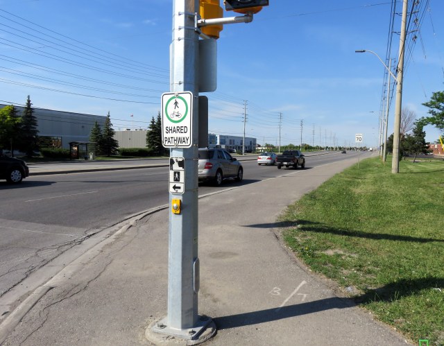
Shared pathway, Derry Road, Mississauga

    (more…)