Tag: Transit

  • Ontario’s new ride: ION LRT opens in Kitchener-Waterloo

    1-IMG_2377.JPG

    On June 21, 2019, Ontario’s first modern light rail transit (LRT) system opened to the public. The launch of ION in Kitchener-Waterloo represents an important milestone for both the region and for the province as a whole: additional light rail systems in Ottawa and Toronto will open in the next few years, while other systems are planned for Hamilton and Mississauga-Brampton.

    There are several things that make ION particularly remarkable.

    Kitchener-Waterloo’s population is much smaller than other cities that have adopted rail transit in Canada and the United States. In 2016, the combined population of the cities of Kitchener and Waterloo was less than 350,000, making Kitchener-Waterloo the smallest urban area in North America to boast such a system (Waterloo Region, which also includes the City of Cambridge and three rural townships, has a population of nearly 550,000). Kitchener and Waterloo were connected by streetcar until 1946, then by a trolley bus until 1973. Kitchener Transit, then Grand River Transit (GRT) continued to serve the two cities.

    Despite the small population, LRT makes sense here, as many of the region’s trip generators line up along a single corridor, including Downtown Kitchener, Uptown Waterloo, the University of Waterloo, several high schools, and the main hospital. It is also within walking distance of Wilfrid Laurier University. ION is also fully integrated with the connecting bus system, which was re-organized in conjunction with the opening of the new LRT to provide more direct routing and better connect with the rail service.

    By operating on dedicated corridors and alongside regular traffic, the ION route also demonstrates the flexibility unique to light rail systems. Where it runs on private rights of way, crossings are protected by railway-style lights, bells, and gates. Where it operates in reserved lanes at street level, there are dedicated signals and transit priority at most intersections. This isn’t just a streetcar.

    2018-route-ION-LRT-map
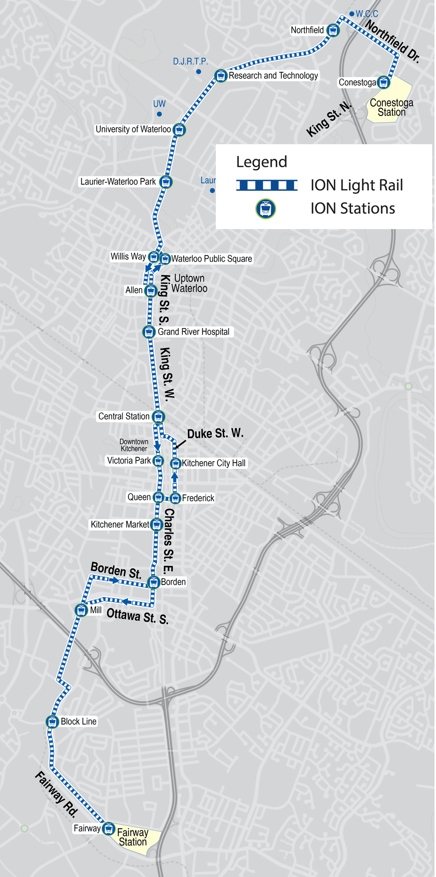
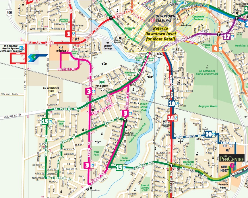
    ION LRT route map, from the GRT website

    Torontonians may be forgiven for confusing LRT with traditional streetcars; ION uses Bombardier-built light rail vehicles similar to Toronto’s new low-floor streetcars, and the TTC has marketed streetcars on Spadina Avenue, Queen’s Quay, and St. Clair Avenue as “streetcar rapid transit” before. The difference, though, is that ION LRT stops are spaced further apart than local streetcar stops in Toronto, they take advantage of signal priority, and they partially run off-street.

    LRT, of course, fills a wide spectrum. At its slowest and simplest is the typical streetcar, such as Toronto’s legacy street railway, or some of the new streetcars being built in the United States, such as Detroit’s QLine or the Atlanta Streetcar. Streetcars in private right-of-ways, such as on Spadina or St. Clair Avenues in Toronto, provide additional reliability and speed. On the other end are metro-style LRT systems completely separated from traffic, often featuring tunnels or elevated structures. Ottawa’s Confederation Line, once it finally opens, will be an example of LRT built to the highest standards. The Ctrain in Calgary comes close to this standard as well, though trains are forced to crawl through downtown on a congested Seventh Avenue transit mall.

    I had the opportunity to ride ION twice in the opening week: the first time, on Monday June 24 (on the way home from a weekend in Stratford) and again with a few friends on Saturday June 29. Trains were consistently packed; GRT reported that over 73,000 passengers rode the LRT during opening weekend.

    1-IMG_2411-001
    ION train at Charles and Benson Streets, wrapping around Oktoberfest headquarters

    Operations were not yet perfected. On Saturday June 29, there were noticeable gaps in service, with workers doing switch repairs at the northern terminal at Conestoga Mall. This caused long waits at the northern end of the line. The automatic train control system was disabled, reducing speeds along sections of track where operators had to operate by line-of-sight.

    The schedules could also be a little faster, with reduced station dwell times. Trains must also crawl through tight corners in Downtown Kitchener, Uptown Waterloo, and at Haywood Avenue. But it was nice to see transit priority working: trains ran through many intersections without having to stop, and speeds were impressive (up to 70 kilometres per hour) on the off-road sections of track.

    1-IMG_2199
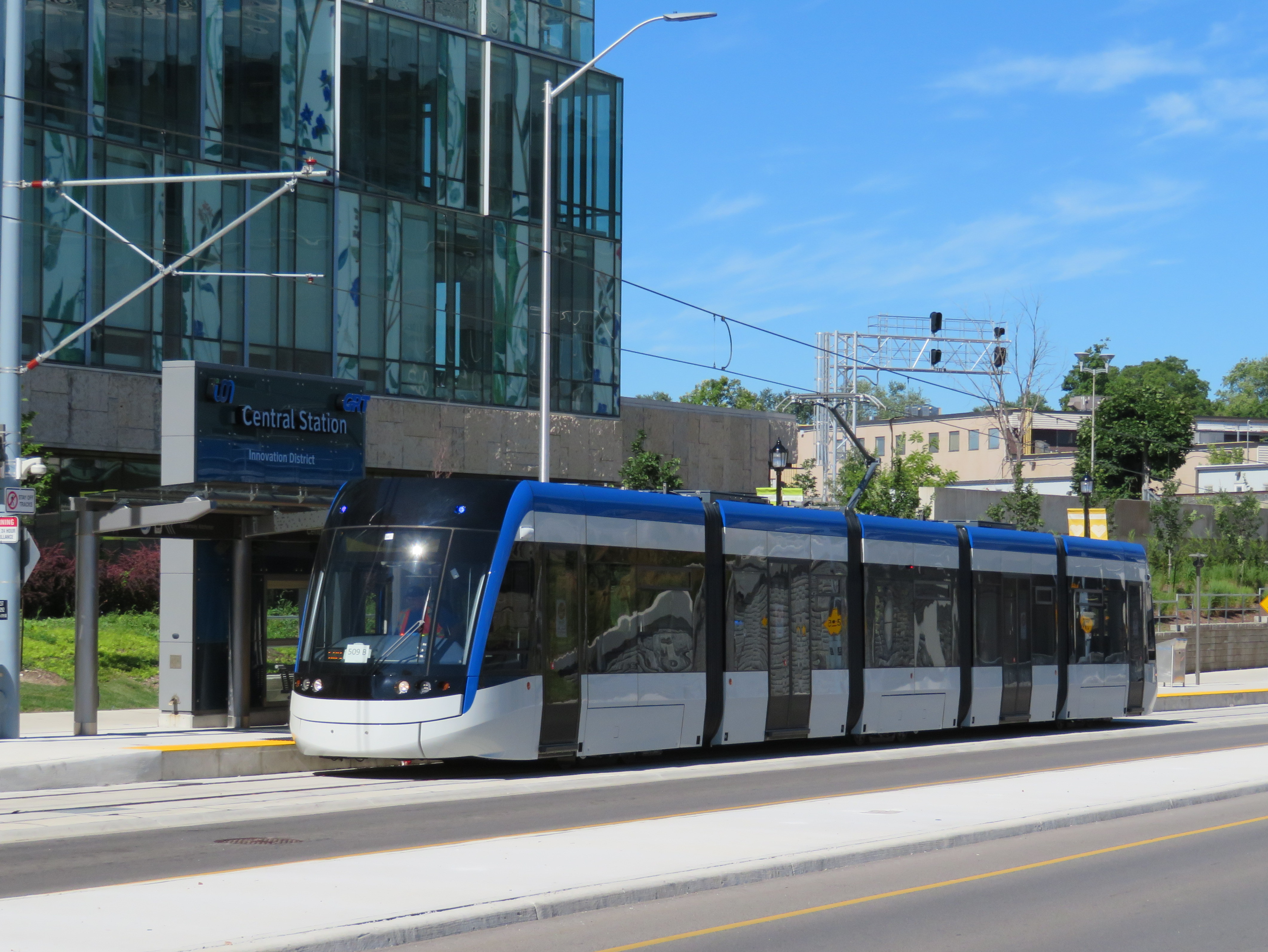
ION train on Duke Street in Downtown Kitchener

    Along the entire corridor, travel times have improved only slightly over the old express bus, the Route 200 iXpress. Between Conestoga and Fairview Park terminals, the scheduled bus time ranged from 45 to 59 minutes, depending on the time of day. The LRT has a consistent 43-minute scheduled travel time between the two terminals. But it still promises to be more reliable.

    The greatest improvements in travel time are between University of Waterloo and Conestoga Mall, Uptown Waterloo, and Downtown Kitchener, where travel times have been reduced by 5-7 minutes.

    A promised second phase will extend ION LRT south to Cambridge. For now, an express bus serves the planned corridor.

    There is certainly room for improvement,  though these at least can be made slowly and incrementally. Hopefully, as passengers and drivers get more used to LRT operations, travel times can be tightened up a bit. But the system will be successful if it attracts more riders (without turning away existing passengers with overcrowding or longer travel times due to transfers from buses), and encourages higher-density, transit-oriented development along the route.

    I will return to Kitchener-Waterloo later this summer once ION is “broken in” and the novelty wears out. Offering free fares during the opening week was a nice way to encourage residents to check out the new service, but overcrowding and inexperience were problems.

    I am hopeful that ION helps to change local attitudes towards light rail and encourages other mid-sized cities and suburban municipalities to follow Waterloo Region’s example.

    1-IMG_2391-001ION train approaching Fairway Terminal. The speed limit on this section of track is 70 km/h.

  • Mind the gap: as Waterloo’s light rail line opens, other connections close

    44248408831_5f34e1eaaa_o.jpg
    ION LRT service will finally commence Friday June 21

    Early in 2019, I had the opportunity to take a trip on Wroute, a new service that connected Guelph, Kitchener, and Burlington. Wroute was an interesting concept, a privately-operated option with characteristics of a bus service, a taxi company, and ride-hailing app. With a fleet of Tesla Model X electric SUVs, Wroute tried to fill a gap left by GO Transit and other intercity transportation operators in the Guelph-Kitchener/Waterloo-Hamilton Triangle. Unfortunately, Wroute ended operations on Thursday May 2.

    As I wrote in my article for TVO, fares were too high for a regular commuter, costing $20 for a single ride between Guelph and Kitchener, and $28 between Guelph and Aldershot, more than double the equivalent GO Transit fares.

    IMG_8407-001Wroute Testla at Guelph Central Station, January 2019

    When Waterloo Region celebrates the opening of the ION LRT on June 21, the bus system in Kitchener-Waterloo will be restructured to better connect with the corridor. Despite the improvements within Waterloo Region, links are still needed to surrounding communities. Hamilton and Guelph remain largely disconnected. With a growing employment base in Kitchener-Waterloo, as well large university and college campuses in all four city-regions, filling the gap is more important than ever.

    Hopefully this will come done soon.


  • The streetcars of Hiroshima: a symbol of resilience

    The Hiroshima Peace Memorial (A-Bomb Dome), with modern Hiroshima rising beyond. Despite its fame, there’s so much more to the city than the memorials.

    My wife and I recently came back from an 18-day trip to Japan. It was my first time visiting the country. We stayed in three cities: Tokyo, Kyoto, and Hiroshima, though we made good use of our Japan Rail Passes and made several day trips as well.

    Despite hundreds of years of history, Hiroshima is best known as the city upon which the United States dropped the first atomic bomb on August 6, 1945, in the final weeks of the Second World War. The memorial (originally the Hiroshima Prefectural Industrial Promotion Hall, but widely known as the A-Bomb Dome) is a UNESCO World Heritage Site, and stands as a reminder of the destructive force and tragedy of modern warfare.

    Most tourists to Hiroshima may only visit the Peace Memorial Park and associated memorials, or take a ferry to Miyajima to visit Itsukushima Shrine and its famous floating gate. But what’s remarkable about Hiroshima is the city’s resilience and pride, and there is much more to see, do, and taste. For me, one of those things is the city’s streetcars.

    The Hiroshima Electric Railway, known as Hiroden for short, operates Japan’s largest street railway network, as well as many local buses and ferries. While most Japanese cities abandoned their streetcars after the Second World War, Hiroshima made a conscious decision to retain its streetcars; they are a symbol of Hiroshima’s resilience. Though 108 out of Hiroden’s 123 streetcars were damaged or destroyed, seven days after the blast, service resumed on the suburban Miyajima line.

    IMG_0264-001Map of the Hiroden streetcar network, with information in Japanese, English, Korean and simplified Chinese

    Today, Hiroden operates 271 streetcars, and it has an eclectic fleet. All streetcars are double-ended, and articulated cars operate with both an operator and a conductor. Passengers pay on exit, though customers using a farecard must tap on and off. (The city fare is a flat 180 yen, though an additional fare is charged on the Miyajima Line.)

    IMG_0279-001Two newer Hiroden low-floor streetcars pass each other on Aioi-dori. 

    Among Hiroden’s assets are two vehicles (#651 and #652) that survived the atomic blast. In the 1960s and 1970s, Hiroshima purchased used streetcars from other cities that were abandoning their systems, including Kyoto, Osaka, and Kobe, some of which still operate today. New articulated low-floor streetcars augment the streetcar fleet, providing barrier-free transit. A complete description of the Hiroden fleet is available on the local transportation museum’s website.

    IMG_0794-001Streetcar #1912 was built in 1957 for Kyoto’s municipal railway. It was acquired by Hiroden when Kyoto abandoned its streetcar system in 1978.

    (more…)

  • Filling the gap in Southwestern Ontario

    9119948871_f1716baa80_oWhile there’s GO train service between Toronto, Guelph, and Kitchener, it’s inadequate for the regions’s transportation demands 

    Earlier this year, I took a ride on Wroute, a new service connecting Guelph, Kitchener, and Burlington that has some characteristics of a bus service, a taxi company, and ride-hailing app. With a fleet of Tesla Model X electric SUVs, Wroute tries fill a gap left by GO Transit and other intercity transportation operators in the Guelph-Kitchener/Waterloo-Hamilton Triangle. It’s an interesting concept, but it is not enough to move commuters quickly, reliably, frequently and, most important, affordably.

    I spoke with two Kitchener residents — James Bow, author and webmaster of Transit Toronto, and Brian Doucet, Canada Research Chair in cities planning at the University of Waterloo — to find out what the region really needs.

    You can read the full article at the TVO website here.

    IMG_8407-001.JPGTesla operated by Wroute at Guelph Central Station

  • Subways don’t always last 100 years

    IMG_7232-001
    Former Toronto Mayor Rob Ford liked to claim that subways would last one hundred years, while other “inferior” forms of transit, like light rail systems, would last only thirty.

    At the time, Ford was pushing for a subway extension to Scarborough Town Centre that would replace the Scarborough RT. The SRT opened in 1985 and nearly thirty years later, the line needed a major rebuild, including new equipment. The City of Toronto planned to replace the aging system with a modern LRT route, including a three kilometre extension with two new stations at Centennial College and at Sheppard and Progress Avenues in Malvern. The line would have been fully funded by the province, and the rebuild would have reduced the cumbersome transfer from the subway platforms.

    Of course, Rob Ford was wrong about subways lasting 100 years. While Toronto’s subway system is over sixty years old — the original Yonge Subway opened in 1954 between Union and Eglinton Stations —  only the tunnels and station structures themselves remain from that era. The Yonge Subway is on its fourth generation of vehicles. Each of the stations have been renovated with new turnstiles, tiling, signage, and elevators. The TTC is also working on a new automated signalling system, and track replacement is an ongoing program.

    Had the Scarborough RT been built as originally planned as an LRT route, there would only be the need for ongoing maintenance and new replacement vehicles. Extensions of the line would have been much easier and cheaper. The problem was that the planned route was converted — with pressure from the provincial government — to an Intermediate Capacity Transit System, a novel technology which was then being developed by the Province of Ontario. The rolling stock — nearing 30 years old — had to be replaced, and Bombardier, the successor to the provincial Urban Transportation Development Corporation, no longer built vehicles that could fit a tight turning radius between Ellesmere and Midland Stations. That’s why, after 30 years, the SRT needs a replacement.

    But you don’t have to travel far to see proof that subways don’t last a hundred years. In Rochester’s case, that city’s subway lasted only twenty-nine years before abandonment.

    IMG_7219-001High Falls, Rochester

    Rochester, New York is an interesting city. It’s best known as the home of Kodak and Xerox, with a few attractions that make it a worthwhile place to visit, including the George Eastman Museum and estate, The Strong Museum, and the most easterly of Frank Lloyd Wright’s classic Prairie Style houses.

    It also has America’s only fully-abandoned subway system.

    The Rochester Subway was one of three subways planned and built in mid-sized American cities after the First World War. All three, coincidentally, were designed to permit streetcars to run under city streets using abandoned canal beds.

    Cincinnati’s subway was the first to begin construction. Work began in 1919 on the path of the old Miami and Erie Canal, which once linked the Ohio River with Lake Erie at Toledo. But costs increased and construction was never completed. Today, the Cincinnati Streetcar runs on top of the abandoned subway route along Central Parkway.

    IMG_5599-001Central Parkway in Cincinnati in January 2015, where new streetcar tracks run above the abandoned subway line

    Rochester was the second city to build a subway line in a disused canal bed. The Erie Canal was rerouted around Downtown Rochester in 1919 and the new subway line — of which less than three kilometres was below grade — was built along the old waterway. A new downtown roadway, Broad Street. was built above the old canal. Service began in 1927 and was abandoned in 1956, as streetcar service in Rochester came to an end. Suburban growth along with population decline in old central city, and the prioritization of new interstate highways, put an end to rapid transit in that city.

    Newark was the last city to build a new subway system in an old canal bed. Opened in 1935, the Newark City Subway was built between the Pennsylvania Railroad Station (which now serves Amtrak, NJ Transit commuter trains, and PATH subway trains to New York City) and northwestern suburbs. The City Subway, which operated PCC streetcars until 2001, later became the core of New Jersey Transit’s Newark Light Rail System.

    IMG_7230-001

    In Rochester, several sections of the abandoned subway remain visible to the public, including both tunnel portals. Stairs leading down from the Broad Street Bridge, which spans the Genesee River and once carried the Erie Canal, allow the general public to get a glimpse of the tunnel (it is also accessible from the Genesee Riverway Trail next to Blue Cross Arena without stairs), and all the graffiti lining the walls.

    IMG_7238-001A public walkway from the Genesee Riverway at the Broad Street Bridge allows visitors to get a glimpse of the abandoned Rochester Subway

  • Some answered questions about Toronto’s next subway extension (updated)

    36354175911_632dc72411_o.jpgYork University Station, August 2017

    Updated October 10, 2017

    Ten months ago, I wrote about some of the unanswered questions about the Toronto Transit Commission’s Line 1 subway extension to York University and Vaughan. At the time, I was concerned about fare integration once the subway opened, especially if suburban GO, YRT, or Brampton Transit passengers headed to York University were required to make new transfers to the subway at Vaughan Centre or Highway 407 Stations.

    We now know the day the six new subway stations will open: Sunday, December 17, 2017. We also know how the TTC, York Region Transit, and Brampton Transit will serve the new extension and York University. And today, we also have some indication of how GO Transit passengers will be affected by the changes.

    YRT Subway Map.jpg
    How YRT and Brampton Transit will serve the Line 1 subway extension
    (from the YRT website)

    On Friday, Premier Kathleen Wynne and Transportation Minister Stephen Del Duca will announce a new co-fare between the TTC and Metrolinx services (GO Transit and Union Pearson Express), to take effect in January 2018. (The Star previously reported that the fare change will take place as soon as the subway extension opens.)

    Transfers from GO Transit or UPX to the TTC will cost $1.50 for passengers using Presto cards, a 50% reduction from the full adult fare of $3.00. Passengers transferring from the TTC to GO or UPX will get a $1.50 fare discount. It is expected that the new co-fare subsidies will cost the provincial government $18 million a year. The fare discount will not apply to passengers using fare media other than Presto cards, including TTC tokens, Metropasses, or paper one-way tickets or day passes.

    These are similar to the co-fares offered between GO Transit and transit agencies outside the City of Toronto, including MiWay, York Region Transit, Brampton Transit, and Hamilton Street Railway. However, these co-fares are generally more generous — ranging from $0.60 in Hamilton to $1.00 in York Region.

    There was no news on reducing the fare penalty for transferring between the TTC and connecting local bus systems such as York Region Transit and MiWay.

    For many commuters, the new TTC co-fare is great news, and it represents a good first step towards proper fare integration. It helps to make GO Transit more useful for trips within the City of Toronto, and it helps suburban commuters who use the TTC for part of their trip, such as University of Toronto students, who are located too far a walk to Union Station.

    (John Tory is also claiming a victory, calling it “a step in the right direction” for his SmartTrack proposal. At this point, “SmartTrack” is little more than a GO/TTC fare agreement and a few new proposed GO stations.)

    However, this could also affect York University students as well. Previous plans for the Line 1 subway extension saw GO Transit buses serve the Highway 407 station, requiring a transfer to the subway to get to campus. York University has been long eager to remove the buses from the York Commons area, which GO and the TTC use as their campus terminals.

    York Region Transit will continue to operate many bus routes into York’s campus, on the Ian Macdonald Boulevard ring road, and Brampton Transit’s Queen Züm bus route will remain on campus. Their university-bound passengers won’t be required to transfer to the subway and pay an additional fare. But it appears, for now, that GO Transit passengers will have to make a connection, costing $1.50 each way. (This will not be the case for in the short term, see update below.) This will also apply to GO train customers on the Barrie Line who currently use York University Station, if that station closes as planned when the subway connection at Downsview Park opens.

    This will be a blow for GO Transit customers who commute to and from York University, accustomed to a one-seat ride direct to campus. But it will be an improvement for GO operations on the Highway 407 corridor, with buses no longer stuck in traffic in the Keele Street and Steeles Avenue area. It will also benefit GO Transit passengers who aren’t headed to York University. Providing good public transit is not be about giving everyone a one-seat ride.

    Despite these benefits, if GO Transit serves Highway 407 Station as planned, it will impact many passengers with a new transfer and an additional $3.00 cost per day. I’m curious what GO Transit’s messaging and final plans will be, because they have yet to communicate their new schedules and connections when the subway extension opens. Hopefully, we will learn the answers to the rest of those questions soon.


    Update: According to the CBC and Metrolinx’s Anne Marie Aikins, there are now no immediate plans to re-route GO Transit buses from York University. at least in the short term. This is a short-term solution, however, because the Highway 407 station was designed with a large terminal for GO Transit buses, and York University has been vocal about wanting the hundreds of GO and TTC buses a day out of the York Commons area.

    I don’t see this as a long-term solution, however. Hopefully Metrolinx and the TTC can figure out how to best serve York University passengers, though that should have been figured out a long time ago. After all, the subway was originally supposed to open by the end of 2015.

  • The streetcar returns to Detroit – but who benefits?

    IMG_1489-001Woodward Avenue at Mack Avenue, August 2017

    I grew up in Brampton, a suburb of Toronto. Our family could not justify long, expensive vacations, but we did make several trips to Detroit and the region, usually to visit the Henry Ford Museum and Greenfield Village. We’d stay at a hotel outside Detroit, usually one with a swimming pool. Besides the museum visit and the pool, my parents would usually include a stop at an outlet mall. We’d also drive through Detroit itself, sparking my enduring fascination with the city.

    Since my first visit in the mid-1980s, the Hudson’s Department Store has been demolished, the Michigan Central Station has been permanently closed and allowed to deteriorate, and several downtown skyscrapers have closed and been abandoned. The city itself continued to lose population as more auto plants closed in the city and surrounding suburbs, and city services declined.

    But on recent trips, on my own or with friends, we started to see the beginnings of what looked like a comeback. New downtown baseball and football stadiums, followed by new office buildings, the re-opening of the long-abandoned Book-Cadillac and Fort Shelby Hotels, the opening of the Detroit Riverwalk and Dequindre Cut multi-use paths, and new residential development Downtown and Midtown.

    On the last trip to Detroit, my wife and I stayed downtown, at a hotel in the David Whitney Building, a formerly-abandoned office tower. We walked around Downtown Detroit and Eastern Market, visited the famous Art Deco Fisher Building, and went to several museums, including the Charles H. Wright Museum of African-American History, and the Detroit Historical Museum, both of which had special exhibitions marking the 50th anniversary of the 1967 Detroit Rebellion (also known as the 12th Street Riot). We ate at great local restaurants as well.

    And I went back to the Henry Ford Museum and Greenfield Village, both of which were as fun and as interesting as I remember.

    We also took the new QLine Streetcar. It was a fun ride, and I’m happy to report that the service was well used by both residents and tourists alike. But I have some serious concerns as well.

    (more…)

  • They call this a “SmartCentre”

    img_7608-001

    The word “smart,” like many buzzwords, is thrown around a lot, to the point that it has lost meaning. SmartTrack, for instance, might have been a catchy name for a transit plan, but in the end, it didn’t turn out to be all that smart.

    There’s also the case of SmartCentres, the retail arm of SmartREIT, a real estate investment trust. SmartCentres are ubiquitous in suburban Canada; the firm owns retail properties in all ten provinces and is Wal-Mart Canada’s largest landlord.

    I was recently in St. Catharines, a mid-sized city of 125,000 on the Niagara Peninsula. I’ll have more to say about my visit there in a few upcoming posts.

    I was walking from the VIA Rail station, on the west side of Twelve Mile Creek, opposite downtown, towards the new St. Catharines hospital on the city’s western outskirts. My route to the hospital (more on that later) took me through a SmartCentre big-box retail complex at Louth Street and Fourth Avenue. Tenants include Real Canadian Superstore (a large supermarket part of the Loblaws group), Wal-Mart Supercentre, Canadian Tire, Best Buy, and LCBO.


    Google map of the big box complex in west St. Catharines

    Like most big box centres, the stores are laid out surrounding a large parking lot. Pedestrians are an afterthought – there are few walkways or connections to surrounding sidewalks.

    A token measure — a bus stop — is located within the property. The bus stop is on the main driveway, but a considerable distance from the front entrances of Wal-Mart or the supermarket, especially for anyone carrying groceries, using a mobility device and/or with young children. Shopping carts are left next to the bus shelters, and there are no other supermarkets in western St. Catharines. Anyone without a car must either visit Superstore, Walmart, or shop at higher-priced local convenience stores. The property owner is SmartREIT, a real estate investment trust with retail properties in all ten provinces.

    stcatharinestransit
    Excerpt from St. Catharines Transit daytime map. Only route 3 serves the big box centre from the south. 

    Only one St. Catharines Transit bus route, 3 Pelham Road, serves the SmartCentre stop (evenings and weekends, route 115 replaces route 3), and only from the south. Traditional shopping areas, such as Downtown St. Catharines and the Pen Centre mall, are much better served by local transit. Route 1, which directly connects downtown and the new hospital and serves neighbourhoods to the north, runs nearby, but it doesn’t enter the property.

    St. Catharines, once an industrial powerhouse, has struggled with de-industrialization and poverty. The census metropolitan area has the lowest median family income in Ontario; the city also has one of the highest obesity rates. Access to fresh, affordable food, especially for those without automobiles, should be a priority. It’s a shame that the built form isn’t smart enough to help.

  • Hallam Street and the Harbord Streetcar

    img_7439-001Hallam Street looking east from Dufferin Street, January 2017

    Hallam Street, which runs east-west from Shaw to Dufferin, north of Bloor Street, is unusually wide for such a quiet, short road. Hallam Street doesn’t provide a convenient thoroughfare for motorists, and nearly every storefront is either vacant, or converted to other uses. Despite being located in a dense urban area of Toronto, Hallam Street has a ghostly feeling when walking or cycling across it.

    So why is Hallam Street so wide? And why does it have so many vacant or former storefronts?

    img_7428-001
    Former storefront on Hallam Street at Delaware Avenue, one of several on Hallam that were converted to residential uses

    For thirty-one years, from 1916 to 1947, Hallam and Lappin Streets hosted the Harbord Streetcar, an interesting and circuitous route that served the northwest portion of the City of Toronto, and later, the east end of the city. Unlike most streetcar routes in Toronto, the Harbord Car refused to follow a grid. It wound its way through several working class neighbourhoods, tying together parts of Toronto otherwise underserved by its transit network.

    The Harbord Car was re-routed from Hallam Street and Lappin Avenue to Dovercourt and Davenport Roads in 1947, as part of a re-organization of transit services in Toronto’s west end (more on that below). The streetcar was fully abandoned in 1966, when the first phase of the Bloor-Danforth Subway opened. (more…)

  • Mapping Toronto’s streetcar network: The age of electric – 1891 to 1921

    People & Historic shots. - [1920?]-1987

    TRC streetcars on Queen Street, c. 1910. Note the old TSR horsecars used as trailers behind the electric cars. City of Toronto Archives, Series 1465, File 722, Item 18

    This post continues from The Horsecar Era: 1861 to 1891 

    In 1891, after obtaining a new 30-year franchise, the Toronto Railway Company went to work electrifying Toronto’s streetcar system. The TRC was a private company, led by William Mackenzie and James Ross. Mackenzie made his fortune in railway construction; together with Donald Mann, he would go on to build a railway empire before it collapsed by the end of the First World War. Mackenzie would also control other street railway and interurban lines in Ontario, including the Toronto and York, the Toronto Suburban, and the Niagara, St. Catharines, and Toronto.

    By 1894, the TRC became fully electrified, providing quicker and more reliable service. In the twenty-five years that followed, new electric railways radiated out of Toronto to points such as West Hill in Scarborough, Port Credit, Woodbridge, and even as far away as Lake Simcoe and Guelph. But after a short sprint of service expansion within the City of Toronto, the TRC refused to extend its services beyond Toronto’s city borders of 1891. The City of Toronto was forced to form its own public streetcar company in 1911, and became determined to take complete control over urban transportation services once the TRC’s franchise came to an end.

    Maps presented only show revenue routes, including peak period variations and some seasonal routes, such as Exhibition services. I omit some minor service and route changes. I welcome constructive feedback as I plan to re-publish these maps elsewhere.

    1894

    Electrification of the Toronto Railway Company began when the Church Street line was converted on August 16, 1892. The last horsecar made its trip on McCaul Street on July 18, 1894. The TRC extended several routes in Toronto’s west end, including King, Dovercourt, Bloor, Dundas and Carlton.

    The Davenport Street Railway Company began operations on September 6, 1892 between Toronto Junction at Keele and Dundas Streets, and Bathurst Street at the CPR tracks, a short walk to TRC Bathurst Cars. The Weston, High Park & Toronto Street Railway Company began operating the same year within the Junction, from Evelyn Crescent to Keele Street, later extending east to the Toronto City Limits at Humberside Avenue. These two companies merged in 1894 to create the Toronto Suburban Railway.

    The Toronto and Mimico Railway was the city’s second radial. After a troubled start in 1892, it extended west to New Toronto by 1894. The Toronto and York built east from Queen Street and Kingston Road to Blantyre Avenue in Scarborough Township. Two short spurs served the town of East Toronto (near today’s Main/Gerrard intersection) and down to the Beach.

    ttc-streetcars-1894

    (more…)