![People & Historic shots. - [1920?]-1987](https://seanmarshall1.files.wordpress.com/2016/11/trc-queen-s1465_fl0722_it0018.jpg?w=800)
TRC streetcars on Queen Street, c. 1910. Note the old TSR horsecars used as trailers behind the electric cars. City of Toronto Archives, Series 1465, File 722, Item 18
This post continues from The Horsecar Era: 1861 to 1891
In 1891, after obtaining a new 30-year franchise, the Toronto Railway Company went to work electrifying Toronto’s streetcar system. The TRC was a private company, led by William Mackenzie and James Ross. Mackenzie made his fortune in railway construction; together with Donald Mann, he would go on to build a railway empire before it collapsed by the end of the First World War. Mackenzie would also control other street railway and interurban lines in Ontario, including the Toronto and York, the Toronto Suburban, and the Niagara, St. Catharines, and Toronto.
By 1894, the TRC became fully electrified, providing quicker and more reliable service. In the twenty-five years that followed, new electric railways radiated out of Toronto to points such as West Hill in Scarborough, Port Credit, Woodbridge, and even as far away as Lake Simcoe and Guelph. But after a short sprint of service expansion within the City of Toronto, the TRC refused to extend its services beyond Toronto’s city borders of 1891. The City of Toronto was forced to form its own public streetcar company in 1911, and became determined to take complete control over urban transportation services once the TRC’s franchise came to an end.
Maps presented only show revenue routes, including peak period variations and some seasonal routes, such as Exhibition services. I omit some minor service and route changes. I welcome constructive feedback as I plan to re-publish these maps elsewhere.
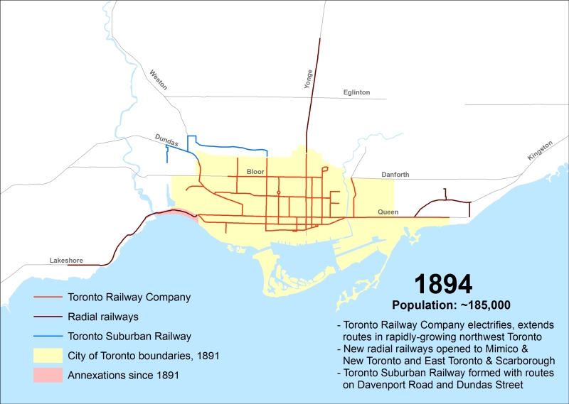
1894
Electrification of the Toronto Railway Company began when the Church Street line was converted on August 16, 1892. The last horsecar made its trip on McCaul Street on July 18, 1894. The TRC extended several routes in Toronto’s west end, including King, Dovercourt, Bloor, Dundas and Carlton.
The Davenport Street Railway Company began operations on September 6, 1892 between Toronto Junction at Keele and Dundas Streets, and Bathurst Street at the CPR tracks, a short walk to TRC Bathurst Cars. The Weston, High Park & Toronto Street Railway Company began operating the same year within the Junction, from Evelyn Crescent to Keele Street, later extending east to the Toronto City Limits at Humberside Avenue. These two companies merged in 1894 to create the Toronto Suburban Railway.
The Toronto and Mimico Railway was the city’s second radial. After a troubled start in 1892, it extended west to New Toronto by 1894. The Toronto and York built east from Queen Street and Kingston Road to Blantyre Avenue in Scarborough Township. Two short spurs served the town of East Toronto (near today’s Main/Gerrard intersection) and down to the Beach.
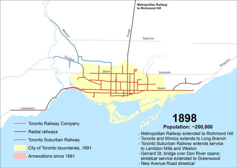
1898
The TRC, the Toronto Suburban and the radials all expanded between 1894 and 1898. The Gerrard Street bridge opened, and the TRC extended service to Greenwood Avenue. A new Avenue Road line was built and streetcars on Bloor reached Lansdowne Avenue. The Toronto Suburban built trolley lines to Weston and Lambton Mills, and radials were extended north to Richmond Hill and west to Long Branch.
Sunday service was introduced on May 23, 1897, after city voters narrowly voted in favour of legalizing streetcars on the Christian Sabbath. It was the third city plebiscite on the subject since 1892.
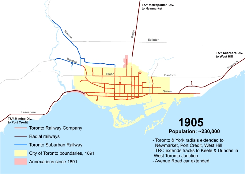
1905
William Mackenzie took complete control of Toronto’s radial railways, amalgamating all three into the Toronto and York Railway Company. Mackenzie was eager to expand: the Metropolitan Railway was extended to Newmarket, the Scarborough Line was built to West Hill and the Mimico Line pushed west to Port Credit.
The TRC and Toronto Suburban agreed to extend City service to the corner of Keele and Dundas, and the Avenue Road line was extended to St. Clair Avenue.
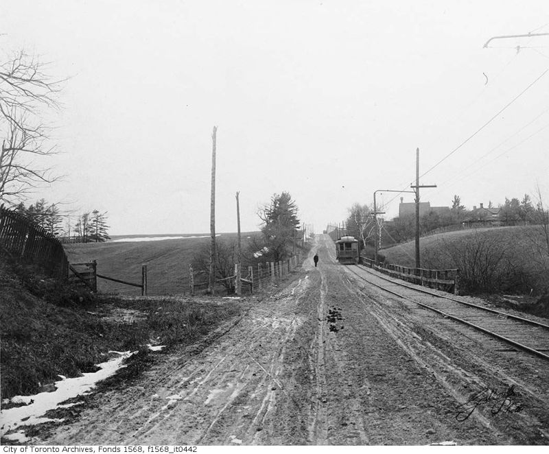 Yonge Street looking north at Jefferson Sideroad, Toronto & York Radial Railway Metropolitan Division. City of Toronto Archives, Fonds 1568, Item 442
1912
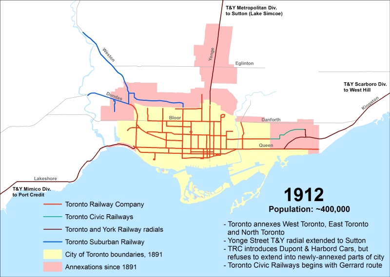
Between 1905 and 1912, the City of Toronto annexed the towns of West Toronto, North Toronto, and East Toronto, among other areas. But the Toronto Railway Company, citing the terms of its 1891 franchise, refused to build new streetcar lines into the developing parts of the city. The Ontario Railway and Municipal Board, now the Ontario Municipal Board (OMB) ruled in the TRC’s favour when the city protested. And in 1911, Mackenzie purchased the Toronto Suburban Railway.
In response, the City of Toronto created its own street railway company, the Toronto Civic Railways. Its first route, Gerrard, opened on December 18, 1912 between Greenwood Avenue and Main Street. The TRC did start two new routes, Dupont and Harbord, but they were within the TRC’s existing service area.
The Toronto & York radials were extended to Jackson’s Point and Sutton on Lake Simcoe. Plans to extend the Mimico Division from Port Credit to Oakville, which would connect with the Hamilton radial railway network, were unfulfilled.
1916
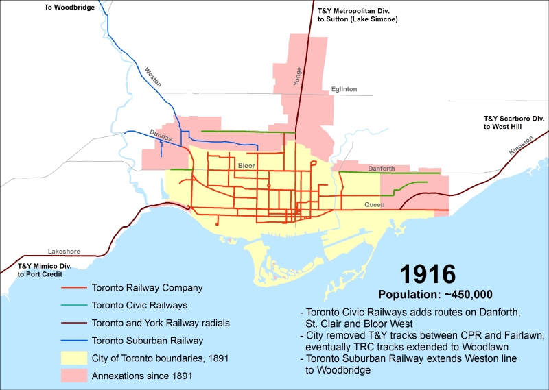
The Toronto Civic Railways added three new routes in the rapidly growing city: Danforth, St. Clair, and Bloor West, while the Toronto Suburban extended its line from Weston to Woodbridge.
The City of Toronto, under Mayor Tommy Church, was openly hostile to Mackenzie’s empire. On June 25, 1915, the day that the applicable Metropolitan Railway franchise expired, City of Toronto crews ripped up the Toronto and York’s tracks between the CPR line and Farnham Avenue, totalling 400 metres of track. After several months, the City built new a new section of double track north to Woodlawn, extending the Yonge line by a few blocks. The TRC’s Harbord line was extended to Lansdowne Avenue.
But with the First World War underway, and Mackenzie and Mann’s Canadian Northern struggling from a cash-flow problem, little new construction was underway, apart from a new TSR cross-country line to Guelph…
1920
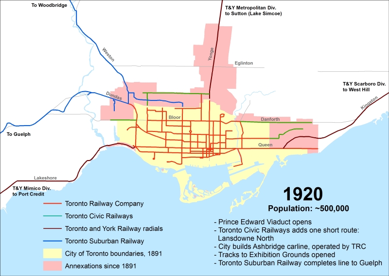
The Suburban Railway’s Guelph line was completed in 1917 as a well built cross-country line, quite possibly intended as foothold for the Canadian Northern Railway to enter Southwestern Ontario, but it was not to be. By the end of 1918, the CNoR was nationalized, becoming a major component of Canadian National Railways.
During the War, very few extensions were carried out unless they supported the war effort. New tracks were laid south on Bathurst to the Exhibition Grounds to assist with wartime needs there. The City also built the Ashbridge line to the Port Lands to serve industry there. The Prince Edward Viaduct opened in October 1918, and Bloor cars were extended across the Don River to wye at Broadview Avenue. The last Toronto Civic Railway line, Lansdowne North, was built between the CPR tracks and St. Clair Avenue.
In 1920, with the Toronto Railway Company’s franchise about to expire, the City of Toronto made plans to take over the transit system once and for all. Much would change over the next decade…
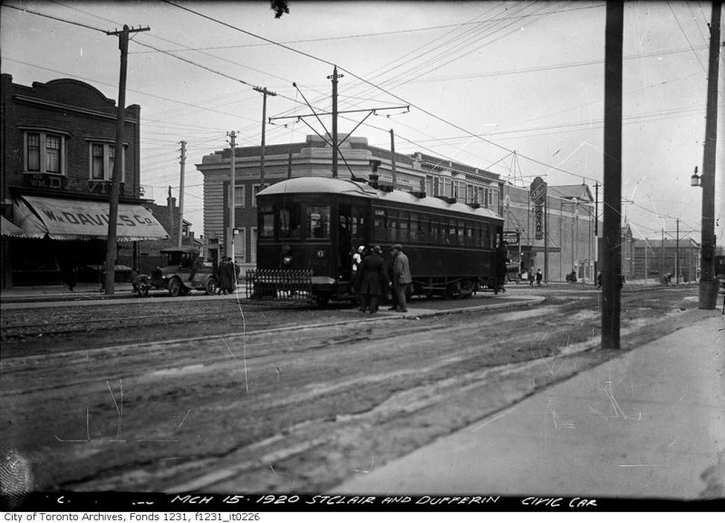 Toronto Civic Railway streetcar, Dufferin and St. Clair, March 1920. City of Toronto Archives, Fonds 1231, Item 226
Next: The TTC era — 1921 to present

3 replies on “Mapping Toronto’s streetcar network: The age of electric – 1891 to 1921”
Excellent post. You can see the development of the Beaches, St. Clair West etc. as “streetcar suburbs” in the early 20th century.
I have some population figures for 1901-1921 for some areas here:
http://southofbloorstreet.blogspot.ca/2015/09/why-east-end-developed-later-than-west.html
[Note the old TSR horsecars used as trailers behind the electric cars.]
I’d never realized that even after studying many publications with them depicted. I often wondered why the trailers looked so radically different to the construction of the motor cars pulling them. I wonder if there was any ‘hotel power’ supplied to them too, or did they keep their kerosene lighting?
Sean, I really like how you have kept the map scale and boundaries consistent from one year to the next. This way, if you save the image files, you can flip back and forth between two years and get an instant understanding of the changes between the two. (Some people make animated GIFs, but with those you lose the ability to control the timing.)
I had no idea that there were ever tracks running down Blantyre to Queen, or on sleepy local streets northeast of Main and Kingston Road. I was sure it must have been an error in the historical record somewhere. Sure enough, though, both of these are specifically listed on Transit Toronto, and the Walter / Lyall / Kimberley tracks show up on one of the later Goad’s Fire Atlas plates.