Author: Sean Marshall

  • The death and life of Shoppers World Brampton

    IMG_5980
    An old Target shopping cart sits in front of Shoppers World. Target, which closed in 2015, now subdivided into smaller retail units, including JYSK, Staples, and Giant Tiger

    Previously on this blog, I wrote about Shoppers World Brampton, a shopping mall that slowly declined despite being located in a high-growth suburban city. I wrote that RioCan Real Estate Investment Trust (REIT), the owners of the mall, were interested in developing the property by reducing the retail footprint and adding new residential uses. Some of those details have now been revealed.

    Shoppers World opened in 1969, on the outskirts of the Town of Brampton, which was transitioning from a county service centre and industrial town to a suburb of Toronto. The mall expanded twice: once in 1973-74, and again in 1980-81.

    In the 1980s, Shoppers World boasted a Simpson’s department store, K-Mart, two full-service supermarkets, a Pascal’s department store, two movie theatres, and even an indoor waterpark. Familiar national chains filled the halls: Thrifty’s, Grand & Toy, Coles and W.H. Smith, Smart Set, Naturalizer, Black’s, Collegiate Sports, Peoples Jewelers, and Reitman’s. Shoppers World never had the status that Square One or Yorkdale enjoyed, but it was a good mall offering just about anything you’d ever need.

    It was where I got my first paying gig: returning stray shopping carts to K-Mart for a few dollars apiece. I lived within walking distance of the mall, though I joked that the best thing about it was the bus to Square One.

    But many of those national retailers left by the mid-1990s. Square One, a 15 minute drive south, was expanding, and Bramalea City Centre had renovated and expanded as well. But when RioCan REIT purchased Shoppers World in the late 1990s, it made some long-needed improvements, including new flooring over the old terrazzo, a new food court, and removing some of the dead retail space for new big-box retailers like Canadian Tire, Staples, and Winners. When The Bay (successor to Simpson’s) closed, it was replaced by more exterior retail.

    Meanwhile, Zellers replaced K-Mart, and briefly became a Target store during the American company’s disastrous foray in the Canadian market. Rio-Can carved that into spaces for smaller retailers, including Giant Tiger. Finally, the bus terminal moved, from a distant corner facing Steeles Avenue, to a central location right at the corner of Main Street and Steeles Avenue, designed for easy transfers to the Hurontario LRT.

    ShoppersWorld

    The interior of the mall is still busy, but nearly all chains let their leases expire, with independent retailers taking over. Even so, there are many vacant storefronts.

    Earlier in October, RioCan submitted their plans to the City of Brampton, and were also presented at an open house at the mall on October 22, 2019. The redevelopment proposal includes new roads, residential towers with at-grade retail, underground parking, among other features.

    Details from RioCan’s submission include:

    • Four new north-south and east-west public streets through the property, including multi-use paths, as several private laneways. Mill Street would continue south from Charolais Boulevard to Steeles Avenue.
    • New residential towers up to 28 storeys tall, containing 4,725 units (one, two, and potentially three-bedroom apartments)
    • 155 townhouses in the northern end of the property, towards low-rise subdivisons north of Charolais Boulevard
    • 44,647 m² (480,582 sq. ft.) of retail space integrated with the residential towers, a reduction from 62,256 m² (670,124 sq. ft.)
    • An enlarged Kaneff Park (west of the mall, between two separate existing high-rise rental tower clusters), along with new community and library space
    • New office space adjacent to the expanded park and community space
    • Most parking will be located underground
    • The Brampton Gateway terminal will remain

    Site Plan of Shoppers World Brampton redevelopment
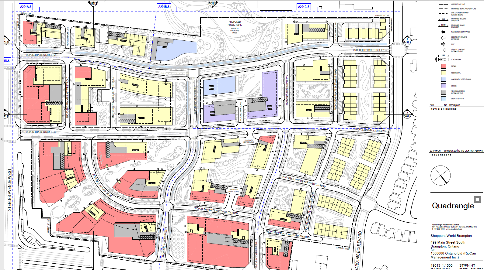
Site plan from RioCan’s submissions to the City of Brampton. Click to enlarge.

    The first phase of the redevelopment will be 27-storey tower on the southwest corner of the site (where the abandoned Brampton Transit terminal now sits). This will be constructed before the mall itself is touched. Further phases will see the mall slowly demolished, though they are dependent on market conditions.

    SWB - View from terminal
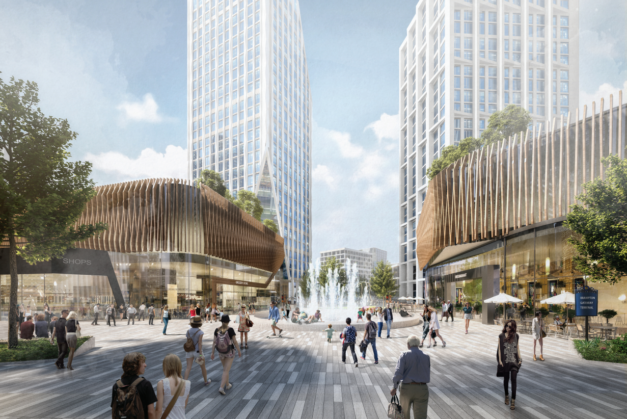
Rendering of Shoppers World redevelopment, looking northwest from the existing Brampton Gateway Terminal

    RioCan hired Quadrangle and SvN architects to develop conceptual renderings for the development, indicating that RioCan is serious about this development. Given the City of Brampton’s own plans for urbanizing this part of the city, I am optimistic this will be built. The area already has good public transit access, with Zum express bus service to Downtown Brampton, Mississauga City Centre, Sheridan and Humber Colleges, as well as local service. This will also be at the terminus of the Hurontario LRT line (construction will begin shortly as the contract was just awarded), which may yet continue to Downtown Brampton.

    This is the largest shopping mall redevelopment in the Greater Toronto Area, following work now underway at the Galleria Mall in Toronto, and proposed for the Promenade Mall in Vaughan (though much of that mall’s structure will remain intact). As the mid-market gets squeezed by discounters, internet shopping, and high-end shopping centres, more malls of Shoppers World’s size will see similar development.

    I was surprised to see such urbanity proposed for suburban Brampton, but it may finally be the time for the Flower City to bloom. Despite my nostalgia for Shoppers World, I am excited for its future.

    SWB Rendering 1.jpgLooking south on Mill Street towards the park expansion and Steeles Avenue. The first phase tower is shown in the middle background.


  • Suburban Toronto’s transit past and future on north Yonge Street

    IMG_4846-001
    Stop 17 shelter in Thornhill

    On Yonge Street in Thornhill, a small green hut sits beside the busy roadway at the entrance to Cricklewood Park. On the side of the small building, a wood sign says “Stop 17.” Hundreds of buses and thousands of cars pass by this hut daily, yet few may know about the transit history it represents.

    Stop 17 was a stop on the Toronto & York Radial Railway line that extended north from a terminal at Toronto’s city limits at Yonge Street and Glen Echo Avenue (now the location of a Loblaws supermarket) all the way to Sutton, via Richmond Hill and Newmarket. Electric radial service to Thornhill and Richmond Hill began in 1897. By 1908, radial service reached Lake Simcoe.

    Stop 17 was one of two stops in Thornhill, located at the present-day intersection of Yonge Street and Royal Orchard Boulevard. The TTC, the eventual owner of most of Toronto’s radial lines, closed the Lake Simcoe route in 1930. Soon afterwards, the wooden shelter was moved to a nearby golf club, where it served as a snack bar and rain shelter. (The radial line was resurrected in late 1930 as a suburban streetcar service to Richmond Hill until 1948.)

    f1568_it0441
    Yonge Street looking south in Thornhill, September 1931. City of Toronto Archives, Fonds 1568, Item 441.

    In November 2000, the Stop 17 shelter was moved back to Yonge Street and restored. It stands as a historical building in Thornhill, and as a monument to early suburban transit in Greater Toronto. Only a few other structures exist from the radial railway era including the Newmarket Radial Arch, the footings of a Toronto Suburban Railway trestle over the Humber River, and a radial power station in Guelph.

    There was another Stop 17, on the Scarboro Radial Line between Toronto and West Hill.  By coincidence, it is also memorialized in the name of a variety store (Stop 17 Variety), which also sports a mural depicting a T&Y radial car stopped in front of the Scarborough High School (now R.H. King Academy).

    Stop 17 VarietyStop 17 Variety on Kingston Road at St. Clair Avenue in Scarborough

    Nearby the Stop 17 shelter in Thornhill, I noticed several markings in the sidewalk. After a closer look, I noticed that they were survey markers, indicating a location where holes were drilled for preliminary core samples for the planned Yonge North Subway Extension from Finch Station to Richmond Hill.

    One day, the subway will be extended north into York Region, a sensible project given the ridership potential, especially as Yonge Street sees urban intensification through Thornhill and Richmond Hill. The City of Toronto has been resistant to the extension, as the Yonge Subway is already operating over capacity, with a relief subway required to handle the loads.

    The politics of subway building aside, it is fascinating to find the history and future of Toronto’s suburban transit in such close proximity.

    IMG_4848-001
    Sidewalk markings on Yonge Street

    IMG_4848-002
    “TTC YSE” marker

  • The road to Paris and London

    Sign with the distance to Paris and London OntarioDistance Sign on Highway 5, Clappison’s Corners

    Early European settlers to Ontario were not very imaginative when they came up with local place names. Although some towns and townships have First Nations names (Toronto, Chinguacousy, Niagara), or named for First Nations leaders allied with the British (Tecumseh, Brant), most cities, towns, and townships were given the names of European settlements, British royals and nobility, or the names of those settlers.

    The list of Ontario towns and cities includes no less than ten world capitals: Athens, Brussels, Delhi, Dublin, London, Paris, Vienna, Warsaw, Wellington, and Zurich. Other towns and cities across the province include the names of British royalty and nobility (Cobourg, Hanover, Port Arthur, Fort William, Richmond Hill) or the towns settler arrived from. These towns can be found throughout the province.

    At Clappison’s Corners, a busy intersection outside of Hamilton, Paris and London appear on the same sign, amusing the occasional visitor. By driving west on Highway 5, Paris is just 42 kilometres away, with London an additional 80 kilometres’ drive via Highway 2.

    The other Covent Garden Market, London, OntarioThe other Covent Garden Market, London

    London was named for the British city in 1793, and was chosen as the site of the new capital of Upper Canada by governor John Graves Simcoe. He felt that the interior location, on the banks of the Thames River (Simcoe named that, too), would be safe from American attack. However, York (now Toronto), became the capital. But London became the regional centre for Western Ontario, and is now the world’s second-largest London with over 350,000 residents.

    Paris OntarioParis, Ontario’s main street backs onto the Grand River

    Paris was named in the 1840s not for the French capital, but for the large gypsum deposits in the area, used to make plaster of Paris. In 2000, the town of Paris was amalgamated with rural Brant County. The community has a population of just 12,000, the third-largest Paris (between Paris, Texas and Paris, Tennessee).

    Before the provincial government downloaded thousands of highways to local municipalities in the late 1990s, Highway 5 ran from Highway 2 (Kingston Road) in Scarborough to Highway 2 again at Paris. At Paris, a motorist could continue on Highway 2 west to London and beyond. New freeways, such as Highway 403, offered a faster trip, while local roads, such as Highways 2 and 5, were downloaded as a cost-cutting measure. Today, Highway 5 runs for just 13 kilometres connecting Highways 6 and 8.

    Today, the route to Paris and London is merely an anachronism of an earlier time, when King’s Highways covered the province and when motorists passed through many small towns on their way to places like Toronto, Detroit, and Montreal. At some point, the sign at Clappison’s Corners will be removed to make way for a new interchange. Until then, this humble monument to European settlement and rural King’s Highways will stand guard.

  • O-Train impressions: this is what LRT looks like

    IMG_4614-001Confederation Line train approaching Tremblay Station

    Last weekend, I visited Ottawa to check out the new Confederation Line LRT. Canada’s newest rapid transit line, delayed by two years, finally opened on Saturday, September 14. It is the second LRT to open in Ontario this year; Waterloo Region’s ION service opened in June.

    The new 13-station Confederation Line includes a 2.5-kilometre tunnel under Downtown Ottawa, with three stations deep underground. Phase 2 will add 15 more stations to the Confederation Line. I was impressed with the speed, accessibility, and capacity of the new LRT, though I noticed a few flaws, some of which hopefully will be corrected.

    The Confederation Line is not the Ottawa Region’s first rapid transit project, however. The Transitway first opened in 1983, one of the world’s first true bus rapid transit systems. Rapibus, a BRT corridor in Gatineau similar to the Transitway, opened in 2013. In 2001, the Trillium Line, a diesel light rail service, opened. It operates on a disused Canadian Pacific Railway corridor through Carleton University. Collectively, the Confederation Line (Line 1) and the Trillium Line (Line 2) are marked at the O-Train.

    IMG_4567-001.JPG
    Trillium Line DMU train approaching Carleton University

    2018_Network_R.png

    O-Train and bus rapid transit map from the OC Transpo website. The Confederation Line is marked on maps and signs as Line 1; the diesel Trillium Line as Line 2.

    The first phase of Line 1 replaces the busiest section of the Transitway, including the congested on-street downtown section on Albert and Slater Streets. Though most sections of the Transitway are grade-separated — following the Queensway (Highway 417) on the east end and an abandoned railway corridor on the west end — the downtown section was the weak link. As OC Transpo, Ottawa’s transit agency operated dozens of suburban express routes into the Transitway during weekday peak periods, lines of buses would often stretch for blocks, an especially inefficient transit operation.

    6205682867_7d38a920b6_o.jpgBus congestion on the Mackenzie King Bridge in Downtown Ottawa in 2011

    With most buses gone from the downtown core, the LRT allows for much more efficient operations, even if many commuters no longer enjoy a one-seat ride to work.

    At several stations, including the Transitway connections at Blair, Tunney’s Pasture and Hurdman, fare-paid areas allow passengers to move between bus and train without having to tap at faregates or show fare payment to the bus operator, like many TTC subway stations. This helps to ensure the LRT is a backbone to a strong feeder bus network, rather than a stand-alone operation.

    Most stations are equipped with escalators as well as multiple stairways. There were two side-by-side elevators at most points, providing the necessary redundancy to ensure full barrier-free accessibility. Access is controlled with fare gates like those in Toronto, where Presto cards, paper tickets, and transfers provide access to platform level. All O-Train stations are identified by a simple red circle at each entrance that looks similar to a Lifesaver candy.

    IMG_4483-002.JPGDowntown entrance to Lyon Station, with the O-Train “Lifesaver” totem

    Unfortunately, some of those rail-bus connections require a long walk outside, such as at Hurdman Station. This was probably the greatest flaw I experienced during my visit last week. Though it was tolerable on a sunny September afternoon, it would be extremely unpleasant in winter or during a rainstorm. It’s unfortunate that the bus terminal was not better thought out to minimize distances between buses and train platforms.

    Ottawa - Hurdman Station
    Bus bay E at Hurdman Station. The bus in the distance is in front of the entrance to the train platforms

    A long-term challenge for the Confederation Line is the ability to direct transit-oriented development around many of the new stations. Though Hurdman Station is major transfer point with the Southeast Transitway, it is located in a floodplain next to the Rideau River. Iris and Blair Stations are located within highway interchanges. There is more potential around Pimisi Station (in the Lebreton Flats, which are already seeing new urban development), St-Laurent (where a second-tier mall could be urbanized), and possibly Cyrville. But all east-end stations are limited by the Queensway.

    These bus transfer and land use concerns were also raised by Alex Bozikovic at the Globe and Mail.


    Vicinity of Hurdman Station
    To the west, however, there is lots of potential for the government office complex at Tunney’s Pasture, which is surrounded by thousands of surface parking lots, as well as eastern Phase 2 stations, which will follow former railway and streetcar corridors, allowing for infill development and urbanization.

    IMG_4502-001Train arriving at the Tunney’s Pasture terminal

    Light rail transit is misunderstood in Toronto, where it is often equated with streetcars, rather than a flexible rapid transit solution. Indeed, light rail covers a wide spectrum, from traditional streetcars, like the TTC’s legacy street railway, to fully grade-separated high-speed LRTs, like Ottawa’s new line. (The Waterloo ION LRT, with a mix of reserved lanes, median operation, and off-road segments, fits somewhere in between.)

    The Confederation Line’s average speed is 31 km/h, with a top speed of 80 km/h. In comparison, TTC Line 1 has a weekday average speed of 28 km/h, and the 501 Queen Streetcar has an average speed of just 9.9 km/h during the morning rush hour. The Waterloo ION LRT currently has an average speed of 21 km/h.

    It is worth noting that the Scarborough RT replacement, once fully funded and ready to start construction six years ago, would have been just as fast and smooth as the Confederation Line. Instead, our local and provincial politicians continue to spin their wheels on planning a subway extension that’s going nowhere. Meanwhile, Ottawa has already started work on Phase 2 of its light rail network.

    IMG_4493-001The end of the beginning: the old Transitway is visible west of Tunney’s Pasture, where Phase 2 of the Confederation Line will continue towards Baseline and Moodie Stations

    The Eglinton-Crosstown LRT will have a long underground segment, with two-car LRT trains similar to those used in Ottawa. When that opens — planned for late 2021 — Torontonians will finally get a taste of high-order light rail transit.

  • The north needs roads

    IMG_2905.JPG
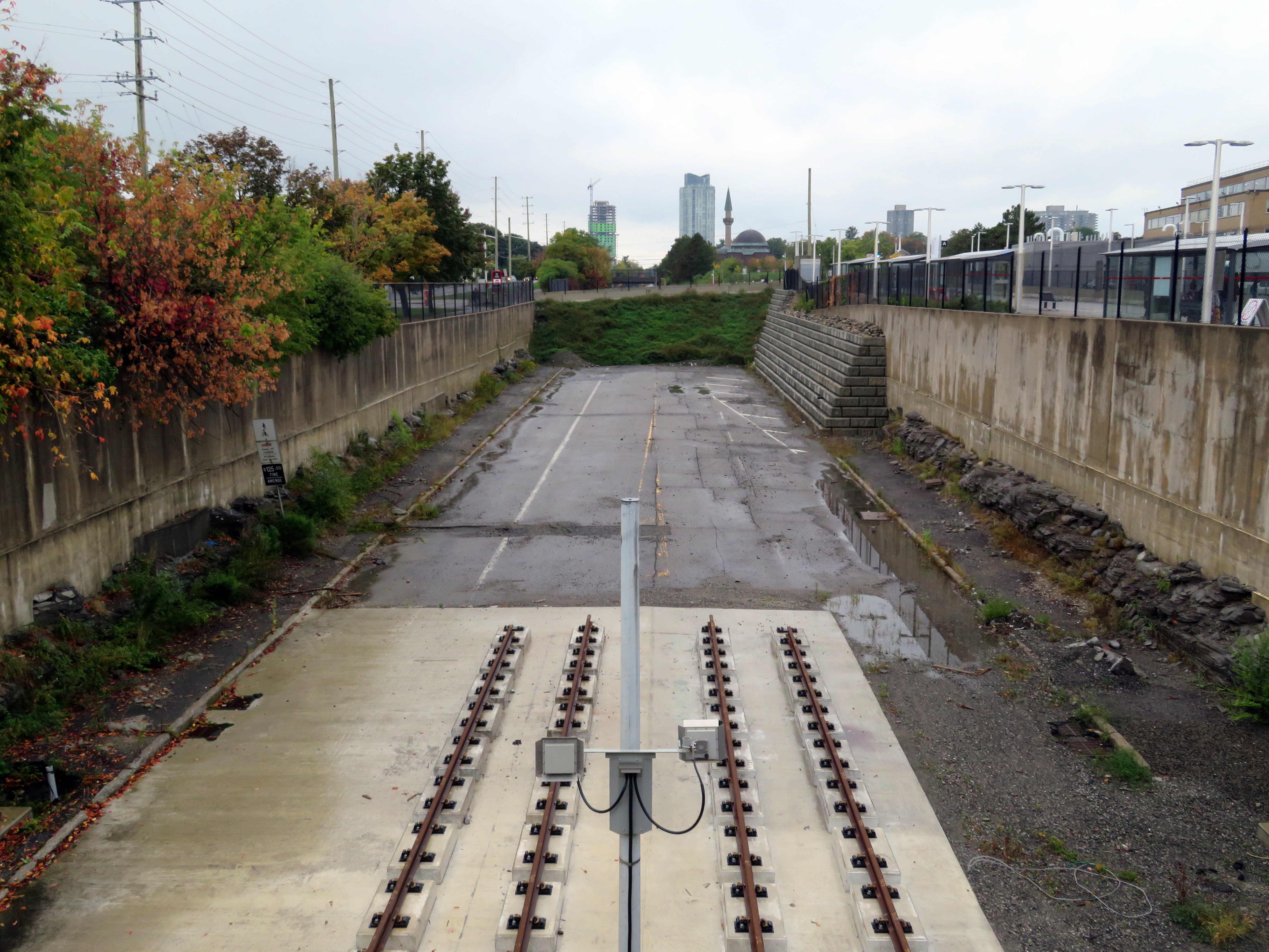
Nipigon River Bridge, August 2019

    In January 2016, a bridge over the Nipigon River failed. Located roughly 100 kilometres northeast of Thunder Bay, it formed part of the Trans-Canada Highway. The only east-west link between Western and Eastern Canada was severed, with the only detour through the United States.

    Climate change, road safety, and access to remote First Nations communities are some of the unique challenges facing Northern Ontario, where highways are especially important. Though highways fall under provincial jurisdiction, the federal government has a role in funding infrastructure and economic development.

    I examine these issues in more detail in my latest article on TVO’s website.

  • Let’s rock out for Vision Zero

    IMG_4345.JPG
    The Major Street Boulder

    On September 18, Toronto Star columnist Jack “The Fixer” Lakey wrote about a boulder that was dug up during construction in the Annex. Bloor Street is currently being dug up between Bathurst Street and Spadina Avenue as the city replaces watermains and reconstructs the roadway. New parkettes at Major Street and Howland Street are also part of the work. As this is going on, bike lanes and parking spaces have been removed, and traffic is rerouted to one side of Bloor Street.

    The billion-year old boulder (its age is unremarkable; the Canadian Shield is older than that) will be incorporated into a nearby parkette. For now, it sits on the side of Major Street immediately south of Bloor. When I visited Thursday evening, the boulder was moved slightly south by a construction crew that was working on the parkette.

    Major Street, despite its grand name, is a minor residential road that leads one-way south from Bloor towards Sussex Street. It is part of a one-way maze of local streets intended to discourage through traffic and permit on-street parking (while frustrating cyclists looking to cut through quiet local streets instead of taking Bathurst or Spadina).

    Lakey was informed about the Major Street boulder by a motorist complaining of turning right onto Major from Bloor and scraping the passenger side as she passed the boulder. She said she couldn’t see the rock because it was below the height of her windows, though there were pylons adjacent to the rock. Lakey visited the site and found two pylons next to the boulder. The city’s response was to ensure that pylons be secured to the rock with caution tape, and to block it off if necessary, as it can not easily be moved.

    IMG_4347-001Bloor Street is a mess of construction and signage as construction continues through September

    Though the city was right to improve the visibility of the boulder, placed in a spot where it wouldn’t be expected, I can’t say I have too much sympathy for drivers who miss it and scratch their cars. Bloor Street is a mess, but it is an active construction site. The bike lanes have been closed off, with cyclists expected to travel with traffic, single file with motor vehicles. The lane configuration has changed, and pedestrians must navigate the construction clutter, signs, and fencing on sidewalks and crosswalks. Such an environment calls for slow and considerate driving.

    The motorist quoted in Lakey’s column said that she could not see the 80-centimetre tall boulder as it was below her line of sight. Other things that might be below a driver’s line of sight at close proximity include pylons, knock-down posts, mailboxes, garbage bins, dogs, cats, recumbent bicycles, strollers, small children, wheelchairs, and other mobility devices. As the average vehicle size has become larger (with Ford and General Motors phasing out sedans in favour of SUVs and light trucks), the line of sight has become higher as well.

    But this gives me an idea that can balance the City of Toronto’s supposed commitment to Vision Zero with the mayor’s desire to keep property taxes too low to pay for the implementation of true Vision Zero across the city. Just add rocks. Lots and lots of rocks.

    Boulders can take a pounding, unlike plastic knock-down poles that motorists can just drive over to get into a cycle track. They can be used to narrow wide residential streets at strategic points and discourage fast turns at intersections. Of course, they can be marked with metal reflective signs, but they’d be cheap to install and very effective.

    Boulders are easy and cheap to source with of all the construction going on in Toronto, with foundations being dug for high rise offices and apartment buildings. But if we’re stuck, we can source rocks from Northern Ontario, where the Canadian Shield is blasted away for resource extraction and the twinning of Highway 69.

    Vision Zero on a zero-vision budget.

  • A departure from TTC wayfinding improvements

    IMG_3566-001.JPG
    TTC stops have improved with the addition of route numbers, but this bus stop is deceiving 

    In the last few years, the TTC has made significant improvements in its maps, signage, and wayfinding standards. It also introduced new streetcar and subway fleets, retrofitted elevators into older stations (all but one streetcar line and a majority of subway stations are now fully accessible), and opened a new subway extension. Though overcrowding, bunching, and weekend closures continue to be aggravations, it is important to recognize where the TTC has improved.

    Specific changes to TTC wayfinding include a new simplified system map, better signage at subway stations, introducing standard signage for diversions, scheduled closures and construction notifications, and revising the classic TTC bus stop.

    However, two recent changes represent an unfortunate departure from these improvements. (more…)

  • How TIFF lost the plot

    IMG_4193-001.JPG504 King Streetcar diverting onto Spadina on Thursday, September 5

    For the sixth year in a row, King Street between University and Spadina Avenues was closed for four straight days. This closure was for the Toronto International Film Festival (TIFF) “Festival Street,” which took place between Thursday September 5 and Sunday September 8. In addition, King Street was closed during the afternoon rush hours the following Monday and Tuesday for “Red Carpet Events.”

    TIFF has been recognized among the world’s most important film festivals, and one where the public has the opportunity to take part (albeit at increasingly inaccessible prices for many screenings). It offers tremendous economic and cultural value to Toronto. It compliments and helps to support many other annual film festivals, such as Hot Docs and Inside Out.

    But TIFF’s clout and influence has also led to entitlement, with “Festival Street” being the most disruptive result. While King Street is closed off to traffic during the film festival, it has severe effects for the 84,000 daily riders of the 504 King Street, as well as riders on the busy 501 Queen and 510 Spadina cars.

    IMG_4191-001.JPG
    501 Queen and 504 King Streetcars stuck in traffic westbound at Queen and Spadina

    Several major TIFF screening locations are located on or near King Street West, including Roy Thomson Hall, the Princess of Wales Theatre, the TIFF Bell Lightbox, and two blocks north, the Scotiabank Cinemas. Industry parties and galas are held at nearby hotels and restaurants. It’s natural that King Street would be a hub of activity for the film festival. But it is also the third busiest transit route in Toronto, after the Yonge-University and Bloor-Danforth subways.

    The King Street Pilot, which began in late 2017, prohibits through motor vehicle traffic on King Street between Jarvis and Bathurst Streets through the downtown core, though all vehicles are permitted to use King Street for short segments. Despite spotty enforcement, the pilot project allowed the TTC to operate much more reliably through the busy corridor, with an increase of capacity and ridership. In early 2017, daily ridership on the 504 King was 72,000. By March 2018, it grew to 84,000. In April, council voted to make the pilot permanent. This will allow for streetscape improvements along the corridor and wider sidewalks, with improved physical measures to further restrict through traffic.

    A lot of political capital went into making King Street work better, so it is disappointing to see all that advocacy for a proper transit corridor go to waste while TIFF is in town. Torontonians are promised each year would be the last year streetcar service would be wrecked for TIFF, but every mid-August, we find out otherwise.  (more…)

  • Trekking across Northern Ontario

    IMG_2761-001.JPG
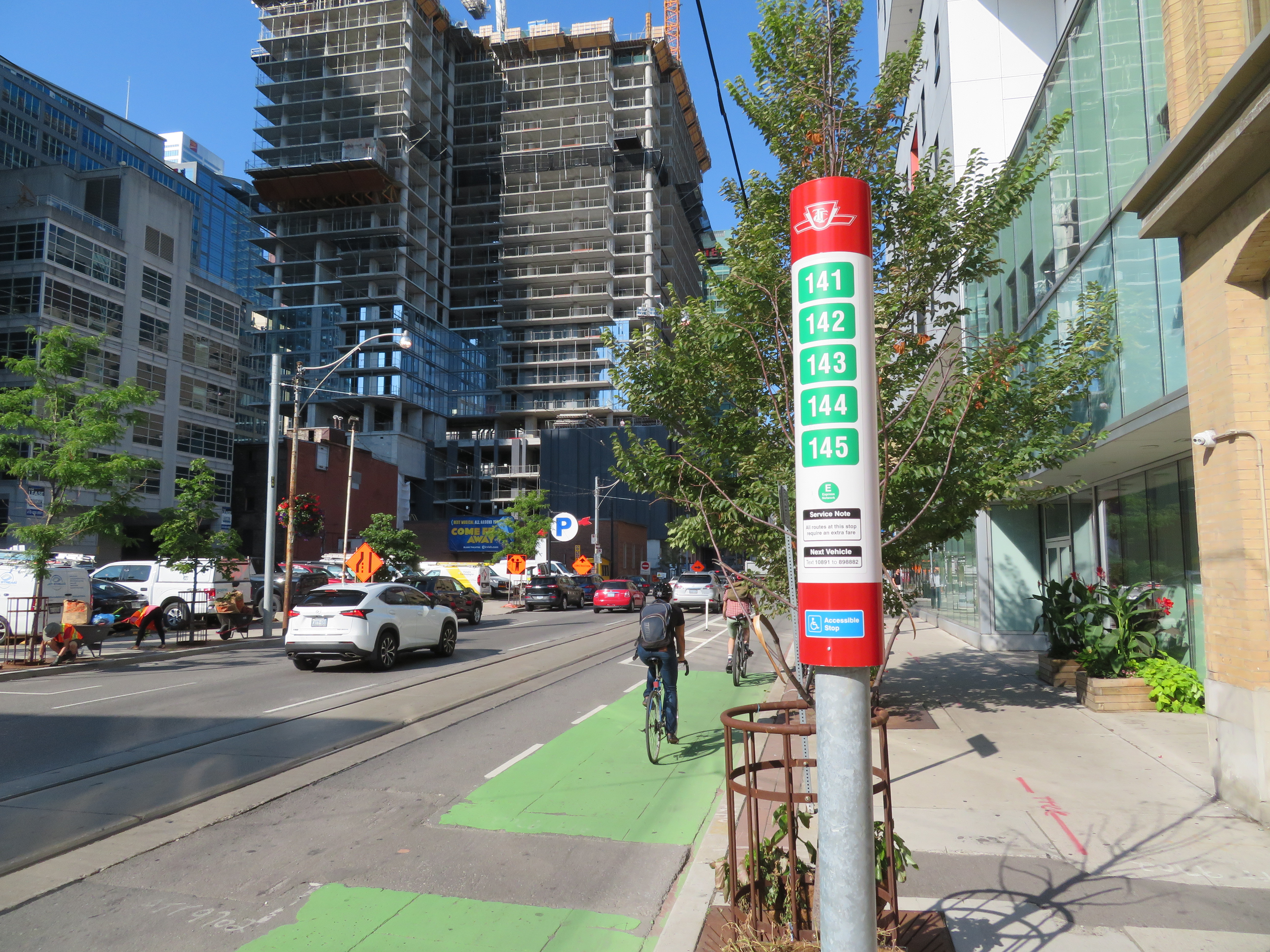
VIA RDC train about to depart Sudbury for White River

    Last month, I embarked on a journey from Toronto to Thunder Bay, a distance of over 1,300 kilometres. My journey took me nearly three days as I opted to travel by bus and rail, rather than by car or by air. Though I had to take three separate trips to accomplish it (an Ontario Northland bus, a VIA Rail RDC train, and a Kasper Transportation mini-bus), it was a very interesting trip.

    IMG_2768.JPGUnloading a canoe from the RDC on the Spanish River, northwest of Sudbury

    Once I arrived in Thunder Bay, I rented a car. Though I know Northeastern Ontario quite well, I had yet to visit Northwestern Ontario (a brief stop in Sioux Lookout on VIA’s Canadian notwithstanding). There are several beautiful provincial parks within a short drive of Thunder Bay, and the city itself has a few interesting sights. Highway 17 along the Lake Superior shoreline is probably Ontario’s most scenic drive.

    Travelling without a car has its challenges, especially as the traveler is at the mercy of sudden schedule changes, traffic delays, and other hiccups, but it is still possible to get across Northern Ontario even after Greyhound’s withdrawal from Western Canada and Northern Ontario last year.

    I wrote about my experience for TVO.

    KasperBusWhiteRiver.JPGKasper Transporation bus at White River – filling the gap left by Greyhound

  • The dangers of Don Mills Road

    IMG_3664.JPGDon Mills Road looking south towards McNicoll Avenue, North York

    On the afternoon of Tuesday July 16, a woman was struck and killed by the driver of a left-turning waste collection truck as she was crossing the street. The tragedy happened at the corner of Cliffwood Road and Barkwood Crescent, in a quiet North York residential neighbourhood. The 68-year old was the eighteenth pedestrian killed on Toronto’s streets in 2019. 

    Cliffwood Road is a typical suburban residential street in northeast North York, just south of the municipal boundary at Steeles Avenue. It meets Don Mills Road twice; at the north end, there are traffic signals, with a middle school and a plaza on the east side of the four-way intersection. On the south side, Cliffwood meets Don Mills at a three-way intersection, protected only by a a stop sign facing Cliffwood. As Cliffwood loops back on itself and has no direct connections to Steeles Avenue, it is not a useful short-cut for speeding motorists unlike many other suburban streets.

    What, in particular, contributed to this deadly crash? I paid a visit to the area to find out.

    IMG_3647.JPGThe intersection of Cliffwood Road and Barkwood Crescent, looking southeast

    Between Don Mills Road and Barkwood Crescent, Cliffwood Road is 12 metres wide without any lane markings or medians to separate traffic or slow vehicles turning off of busy Don Mills Road. West of Barkwood Crescent, Cliffwood Road narrows to 8.5 metres. Twelve metres is a lot of road space: Beverley Street in Downtown Toronto is the same width, but it has two driving lanes, a parking lane, and two unprotected bike lanes. The wide street width here only encourages motorists to drive fast after coming off Don Mills Road, while wide curb radii at the corners at Don Mills and at Barkwood Crescent also encourage motorists to take turns quickly.

    At Barkwood Crescent, Cliffwood Road has a speed limit of 50 km/h, the default speed limit in the City of Toronto. Closer to the schools to the north, a 40 km/h speed limit is posted, but there are no physical measures to slow down cars and trucks. Cliffwood Road, like so many other suburban streets, was built for speed, and not for local residents on foot.

    IMG_3648-001An unnecessarily large intersection at Cliffwood Road and Barkwood Crescent, and a wide approach to Don Mills Road

    I also noted the condition of nearby Don Mills Road, a busy thoroughfare connecting office parks in Richmond Hill and Markham with Fairview Mall to the south. Don Mills is a busy bus corridor, with both TTC and YRT buses providing frequent weekday service.

    Despite the frequent bus service, Don Mills Road is hostile to pedestrians and transit users. At the southern intersection of Don Mills and Cliffwood Roads, the nearest crosswalk is nearly 300 metres to the north, or 600 metres to the south. Understandably, most transit users will choose to cross at the nearest TTC stop, rather than walk an extra five or ten minutes twice a day, especially in inclement weather.

    In late August, a pedestrian was crossing Sheppard Avenue East in Scarborough to get to a nearby TTC bus stop when she was fatally struck by a motorist who then fled the scene. That stretch of Sheppard Avenue is flat and straight.

    IMG_3652-001The corner of Cliffwood and Don Mills Roads with bus stops

    Most area bus stops are adjacent to bus bays. Bus bays are designed to get buses out of the way of traffic while they are dropping off and picking up passengers. Once the bus is ready to leave the bus stop, it must then merge back into traffic. In addition, many of these bus bays double as right-turn lanes, increasing the distance a pedestrian must cross the street.

    Furthermore, Don Mills has several hills and curves north of Finch Avenue that makes this especially dangerous because of low visibility, making it difficult to judge how far or how fast traffic may be coming. There are five lanes plus bus bays/right turn lanes; the centre lane alternates between serving as a left turn lane or a striped buffer space between northbound and southbound traffic, which further encourages high speeds.

    IMG_3663-001.JPGBus stop at Don Mills Road and Mogul Drive, illustrating the high-speed curves

    It is no wonder too that cyclists choose the sidewalks. Despite the wide right-of-way with generous boulevards between the backyard fences and the curbs, no though has been made to improve cycling infrastructure in this part of Toronto. Separated bike lanes or a multi-use path, similar to those on Eglinton Avenue in Etobicoke, or in Peel Region, would make sense here, and along other suburban arterials.

    Cross-ride marking and signals at intersections would improve the safety for suburban cyclists and legitimize a common practice.

    IMG_3630-001Cyclists take the sidewalk on Don Mills Road

    At the end of my tour of upper Don Mills Road, I could not help but notice I was walking in a signed “Seniors Safety Zone.” As with Eglinton Avenue East in Scarborough, signs were put up but no measures were put in place to slow motorists down, and there was no sign of police enforcement of the posted limit either.

    IMG_3684-001.JPG“Seniors Safety Zone” – note the bus bay behind the sign

    There are a few things that can be done in Toronto’s suburbs to improve the safety of vulnerable road users (pedestrians and cyclists) and reduce the incidence and severity of crashes when they do happen. The installation of safer pedestrian crossings, such as traffic signals would reduce the distance required to get to a TTC stop safely. Bus bays should be eliminated with every road reconstruction project, as they do not benefit transit riders and encourage fast-moving traffic. Finally, residential streets should be narrowed, especially at intersections to slow motorists down, reduce the time a pedestrian is in the street while crossing, and improve their visibility.

    Finally, wide multi-use paths along suburban corridors like Don Mills Road would help promote active transportation and reduce conflicts between pedestrians and cyclists.