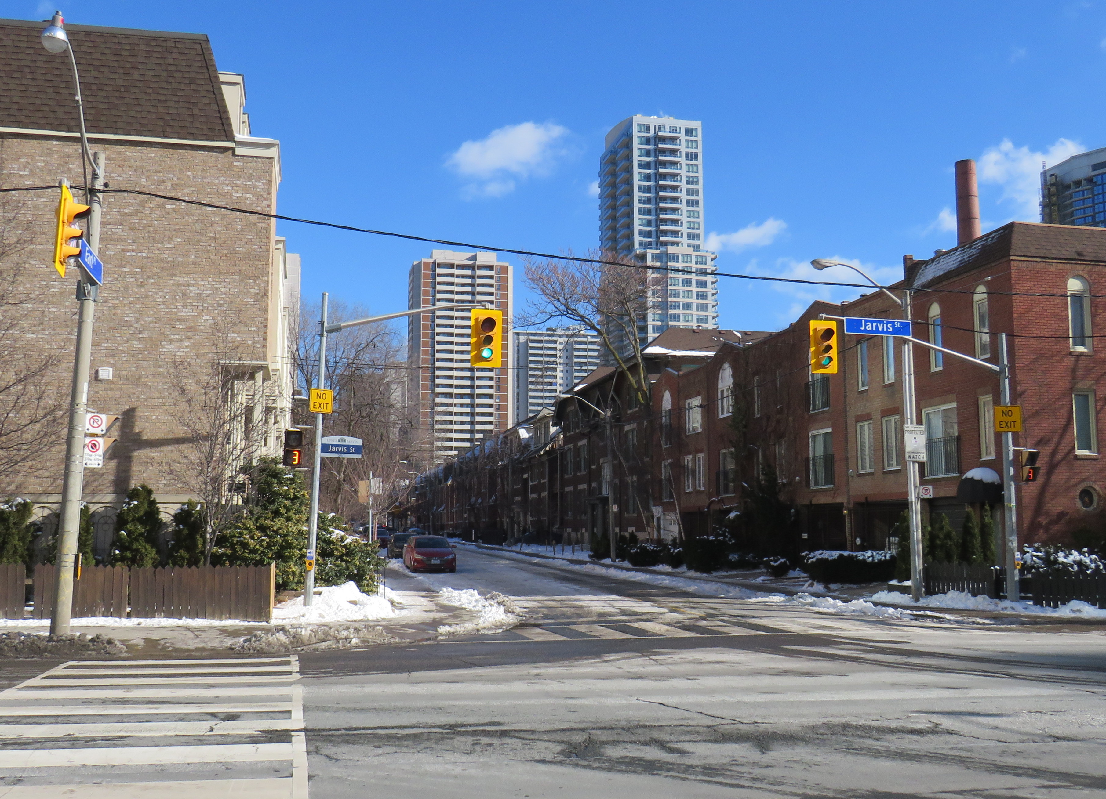
Earl Place, where “No Exit” signs betray through access for pedestrians and cyclists
Last week, Dylan Reid and I, both co-founders of Walk Toronto, decided to create an inventory of all instances in the city where “No Exit” signs do not apply to all road users. Though these signs are required under traffic codes and regulations, they do not reflect that in many cases, there is an exit for pedestrians. Some of those offer through passage for cyclists as well. We were inspired by a Twitter thread that expressed the frustration of getting around the city by foot, where signage is designed entirely for motorists.
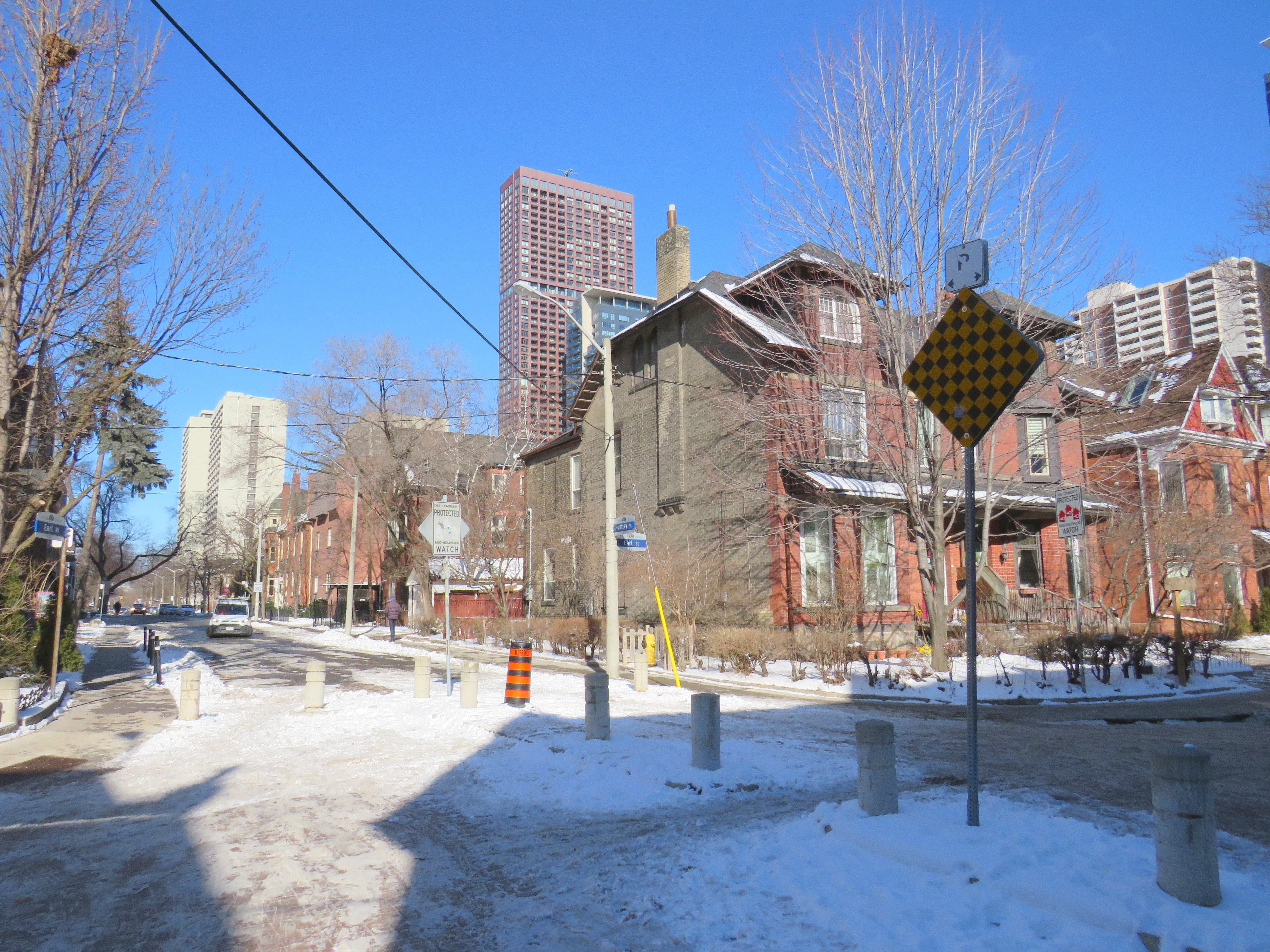
Instances where pedestrians or cyclists may continue past a “No Exit” sign include traffic calming measures meant to keep out through motor vehicles on once-continuous roads. The intersection of Earl Place, Earl Street, and Huntley Street is just one example: curbs and bollards restrict motorists from continuing through, though a narrow passage allows cyclists to continue past; sidewalks also allow through pedestrian movement.
Earl Place and Huntley Street
In many other cases, suburban street designs, such as cul-de-sacs, limit vehicular movement though residential subdivisions, but narrow public walkways allow pedestrians access to parklands and neighbouring streets. In other cases, changes in grade between streets allow for a staircase, but not a through roadway down a steep hill. These are common in the Swansea, Baby Point, Silverthorn, and East Toronto neighbourhoods.
As of January 30, 2021, I have mapped over 250 misleading “No Exit” signs throughout the City of Toronto, though I know there are many more. Please send them to me via Twitter or via a direct message, and I will be sure to add your submission.
Our goal is to convince the City of Toronto to add signage recognizing where pedestrians and cyclists do have an exit. Perhaps too, this might inspire you to get outside, and walk around the neighbourhood, checking out passageways you might have not known about.
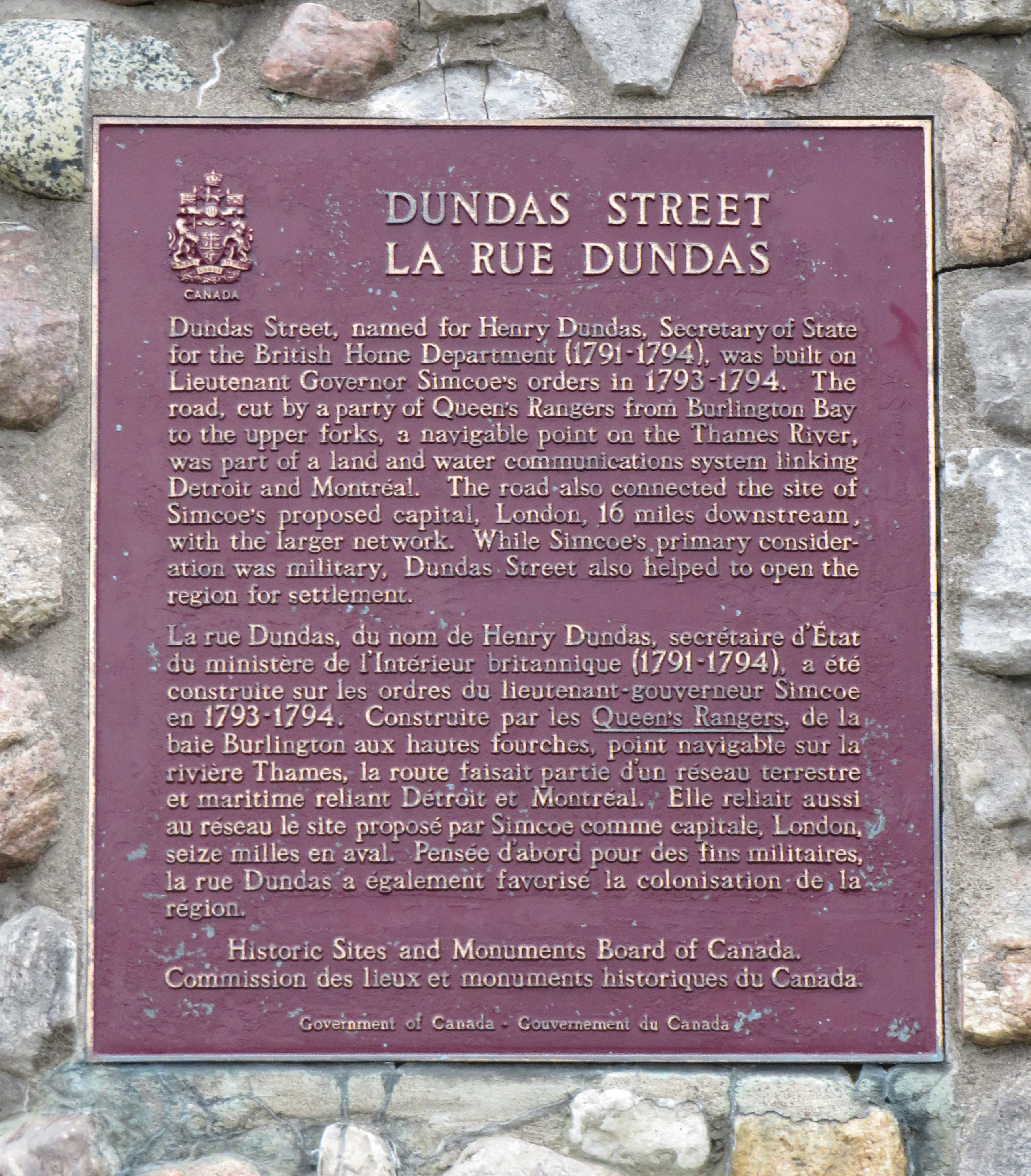
In June 2020, Toronto-based artist and activist Andrew Lochhead launched a petition to rename Dundas Street, one of Toronto’s oldest, longest and best-known arterial roads. Lochhead states that Henry Dundas, 1st Viscount Melville “actively participated in obstructing the abolition of slavery in the British Empire from 1791 to the end of his political career in 1806.” While some historians may argue that Dundas was a pragmatic moderate, rather than an anti-abolitionist (unlike slave-owning Torontonians like William Jarvis or Peter Russell, who have streets named after them), it’s still worth wondering why Toronto has a street named after the Scottish politician, who had nothing to do with Toronto’s colonial history.
Until recently, I gave Dundas Street little thought. Years ago, I wrote about how the street was pieced together in the late 19th and early 20th century to provide a new through east-west route across central Toronto. Though I was aware that Dundas Street began at the present-day corner of Queen Street West and Ossington Avenue, I had long thought the road was named for the town of Dundas, to which it leads.
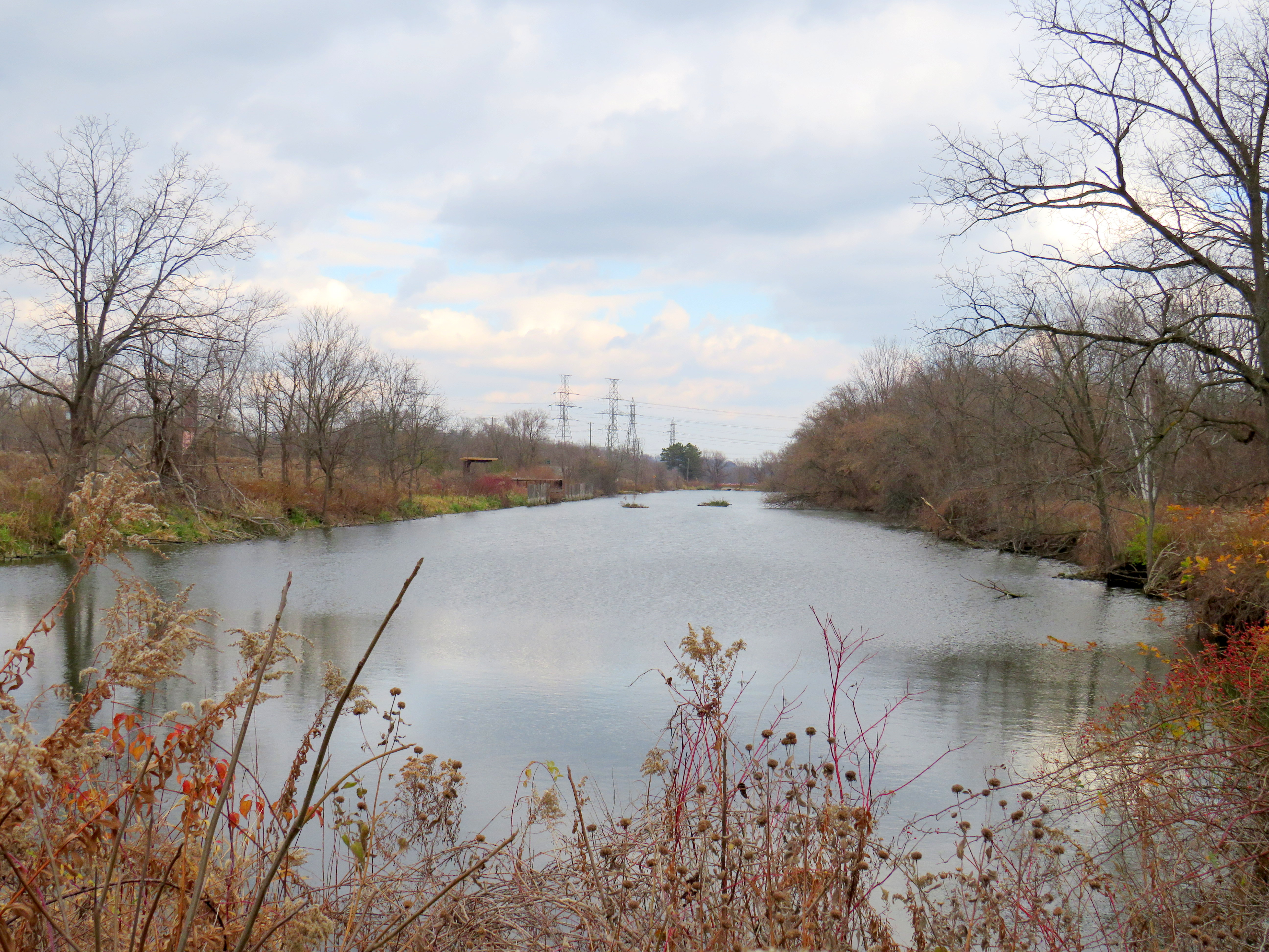
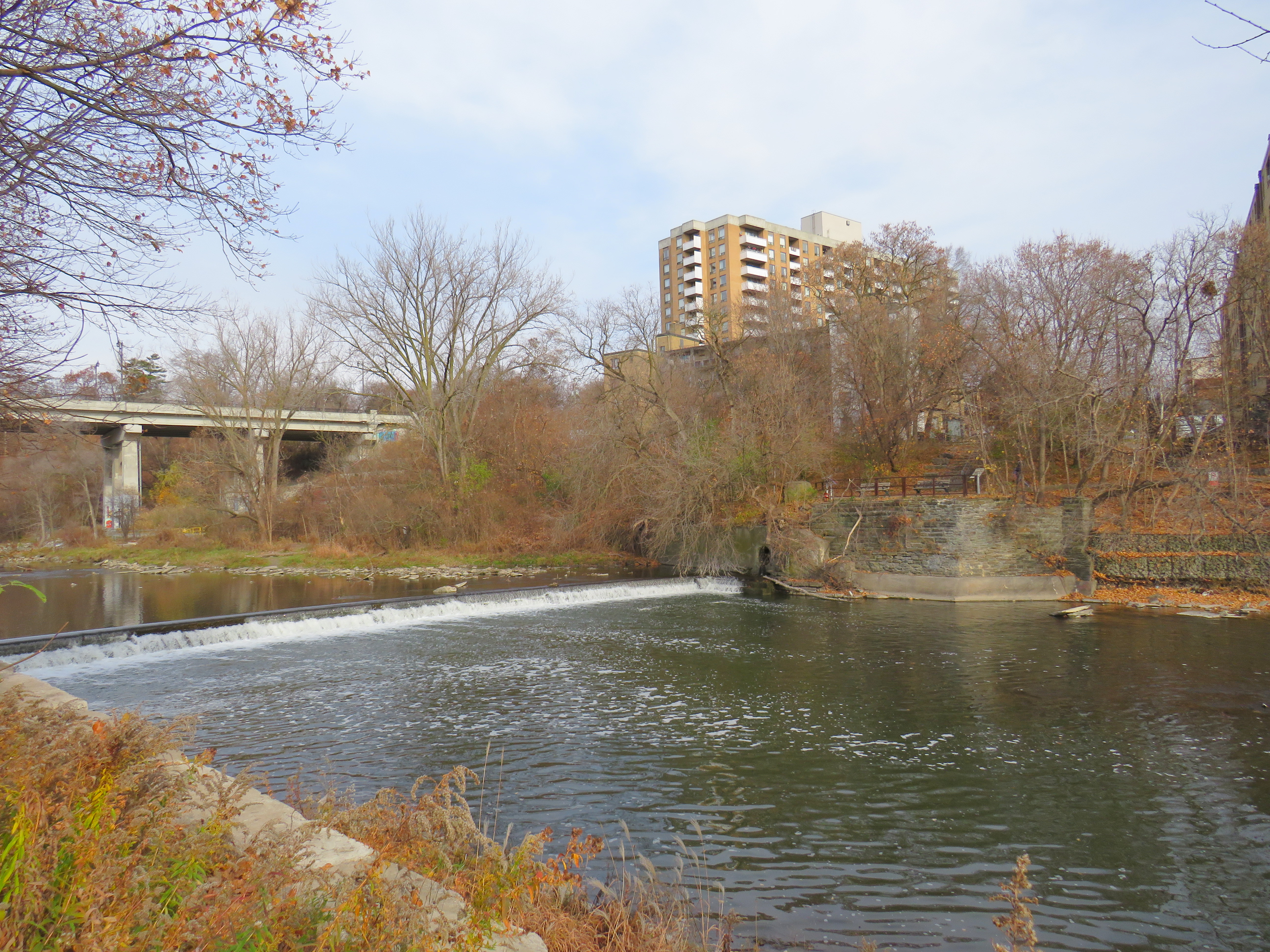
The end of Desjardins Canal, in the old Town of Dundas
Dundas Street was established as a military supply route by order of John Graves Simcoe, the first British governor of Upper Canada. At first, it was surveyed and cleared in 1794 and 1795 between Cootes Paradise (at the very end of Lake Ontario, beyond Burlington Bay) and the Upper Forks of the Thames River, at what is now Woodstock. From there, small boats could be used to travel downriver to London and to Lake St. Clair. Though there were several Indigenous trails connecting Lake Ontario and the Thames River (the western part of Mohawk Road in Hamilton follows one such route), the new British colonial government favoured a straight, direct road.
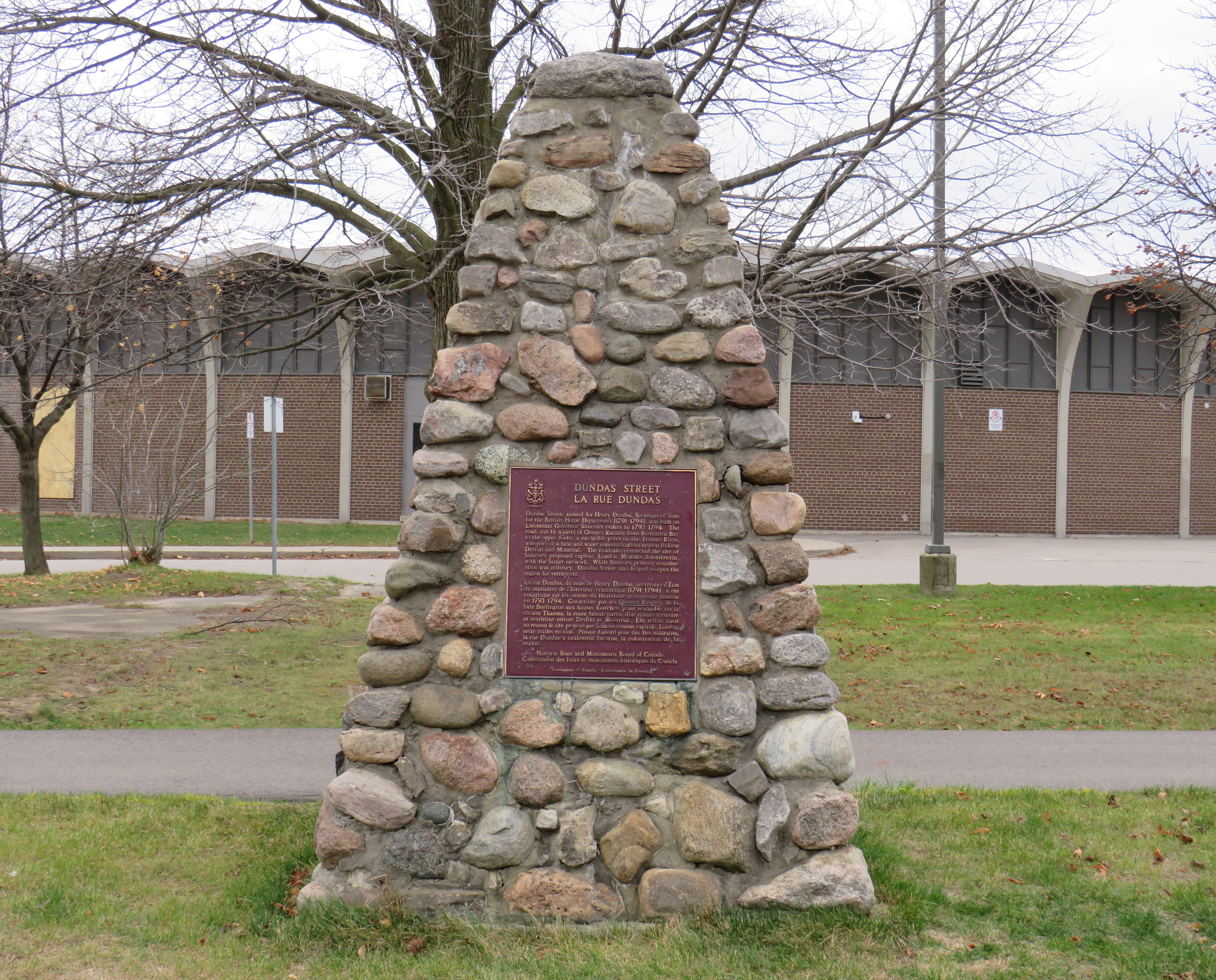
A federal plaque on a cairn in front of Dundas Valley Secondary School in Dundas
Though Dundas Street (which is known as Governor’s Road between Dundas and Paris) features a gentle climb up the Niagara Escarpment, detours were quickly established to get around challenging terrain, such as the confluence of Grand and Nith rivers near Paris. Dundas Street was soon extended westward, to Simcoe’s preferred capital site at London, and extended eastward, to York (Toronto).
Yonge Street, which was originally surveyed and cleared between Lake Ontario and the Holland River near Lake Simcoe, served a similar purpose as Dundas Street. Combined with Penetanguishine Road, Yonge Street provided a military supply route to Lake Huron, though bypassing the established Toronto Carrying Place trail. Though Dundas and Yonge Streets were built with military goals in mind, they, like many other early colonization roads, helped to promote new settlement of lands claimed from local First Nations. Like Dundas Street, Yonge Street was named for a senior British official — George Yonge, who was the British Secretary of War in 1793.
In its early years, Dundas Street’s position inland from Lake Ontario was advantageous as it provided an alternate route in case of invasion. The winding route through Etobicoke and West Toronto to Ossington Avenue allowed travellers to avoid deep ravines and Grenadier Pond.
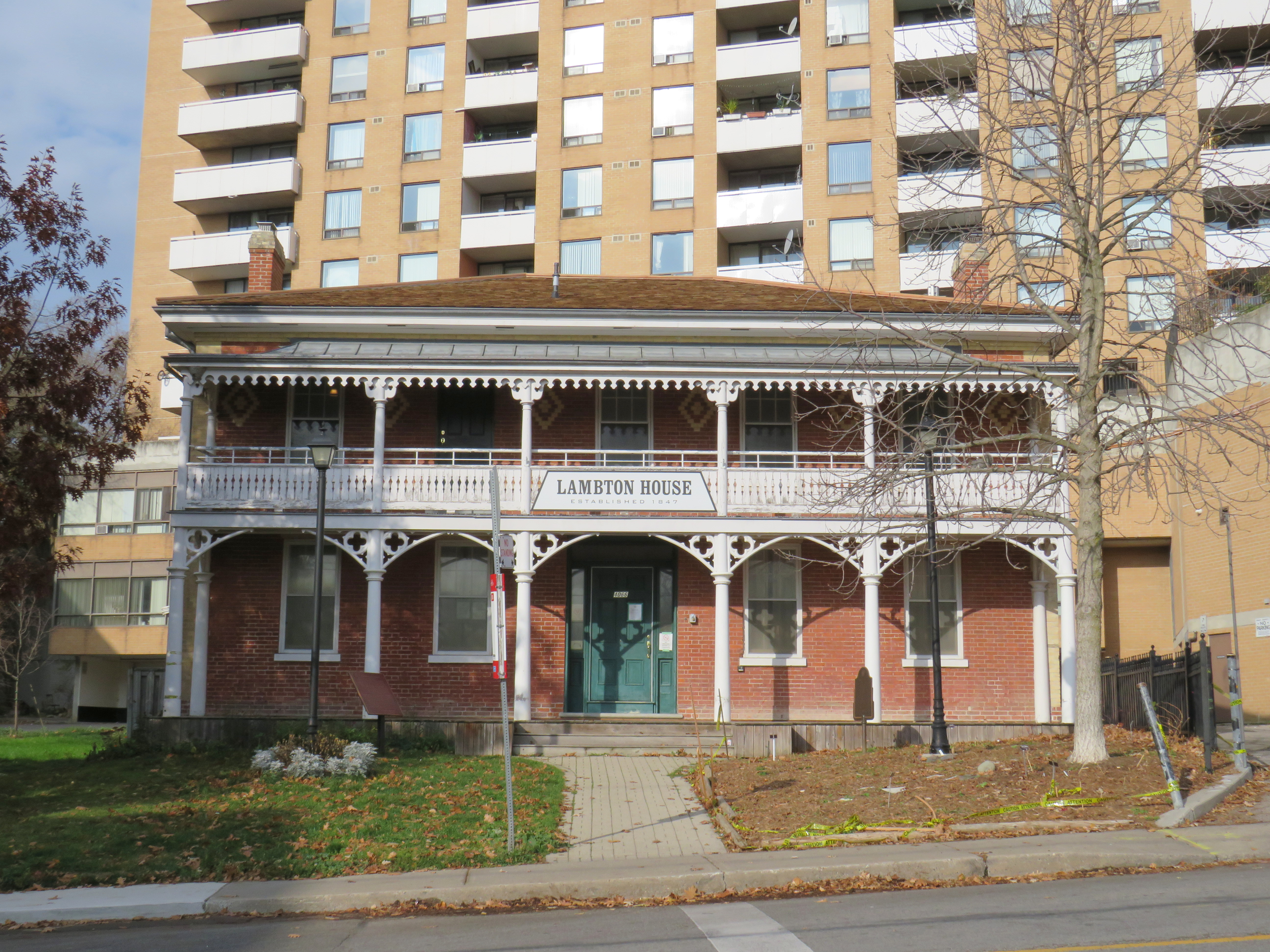
Lambton House, Old Dundas Street
Other early settlement routes, such as Weston Road, branched off of Dundas Street, leading to newly settled lands to the north and northwest of Toronto. Taverns dotted the route, providing accommodation and libation to travelers, several of which — including Lambton House and Montgomery’s Inn — survive to this day.
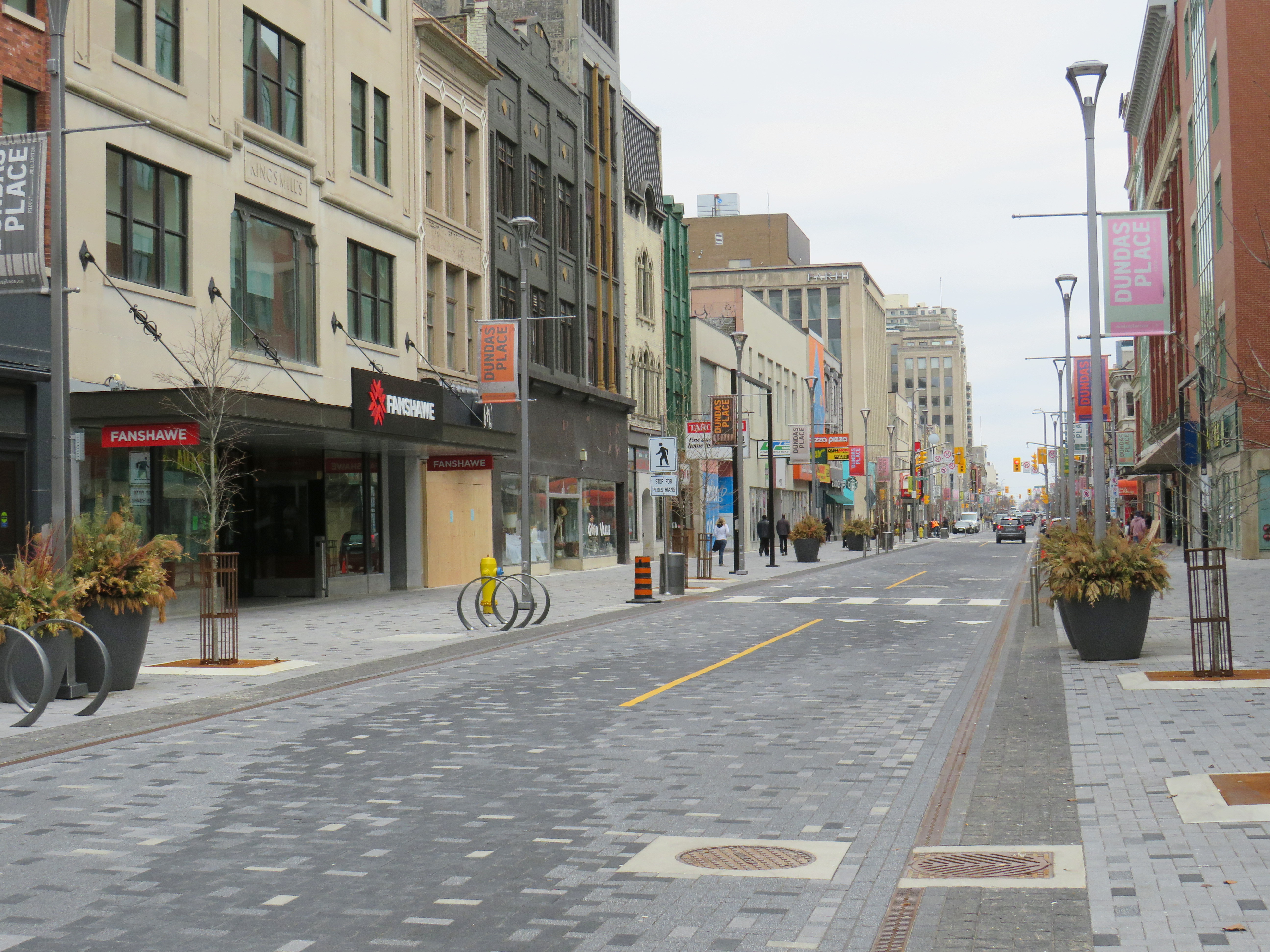
In London and Woodstock, Dundas Street formed the basis for each city’s downtown core. In London, it was recently rebuilt as a two-lane flexible street called Dundas Place, intended to host public events and revitalize the street, which has seen a loss of business to suburban malls and big box stores and to trendier bars and restaurants on Richmond Street, closer to Western University.
Dundas Street in Downtown London was recently rebuilt as a flexible street
Outside the cities, though, other routes surpassed Dundas Street in importance by the mid 1800s. The Lakeshore Road soon became the preferred route between Toronto and Hamilton (which overtook the town of Dundas in size and importance), while the railways, established between Toronto, Hamilton, and London in the 1850s, further eroded Dundas Street’s importance as a major through route until the automobile gained in popularity.
Much of the road between Paris and London became part of interprovincial Highway 2, which extended across Eastern Canada from Windsor, Ontario to Halifax, Nova Scotia. The Waterdown-Etobicoke section became part of Highway 5, while the lesser-travelled section between Paris and Dundas (which today is known as Governor’s Road) was established first as Highway 5B in 1938, then as Highway 99 in 1940.
The remains of the old Dundas Street bridge over the Humber, removed in 1928, looking west to the former settlement of Lambton Mills. The replacement high level bridge is seen to the left. The approaches to the old bridge are named Old Dundas Street.
The Dundas-Waterdown section, which winded its way up the escarpment (only to descend it again a short distance east), became a minor road, with part of the original alignment abandoned by the 1850s.
Though it never held the status of Toronto’s main street, Dundas Street would gain in importance and length in the 19th and early 20th centuries. As Toronto grew beyond its early street grid, it came up against the park lot system devised by Governor Simcoe and other officials to establish a landed gentry in the new colony (including the slaveholding Jarvis and Russell families, who worked to prevent Simcoe from instituting a complete abolition in Upper Canada). These lots which were long and narrow, extended north from Lot (now Queen) Street, and each were developed independently. This resulted in a mess of east-west streets that did not necessarily meet each other. Though College Street was laid out with minimal difficulty, there was no continuous east-west street between College and Queen Streets east of Ossington Avenue.
Dundas Street West, looking southeast from Dovercourt Avenue towards the downtown skyline. This is part of the 220-year old western extension of Dundas Street from the head of lake to York (Toronto).
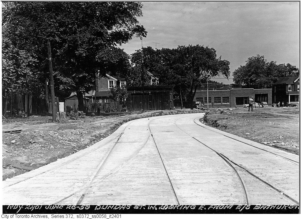
But by the early 1910s, Dundas Street was extended eastward, at first to Bathurst Street, following Arthur Street — which was widened to permit Toronto Railway Company streetcars — and then east to Yonge via St. Patrick, Anderson, and Agnes Streets. Jogs between these streets were slowly realigned, starting with the St. Patrick-Anderson-Agnes jogs between McCaul Street and University Avenue. However, it wasn’t until 1953 that the jog between former Arthur and St. Patrick Streets at Bathurst Street was eliminated. Scadding Court Community Centre now sits on the old roadway, though a small part survives as the centre’s staff parking lot.
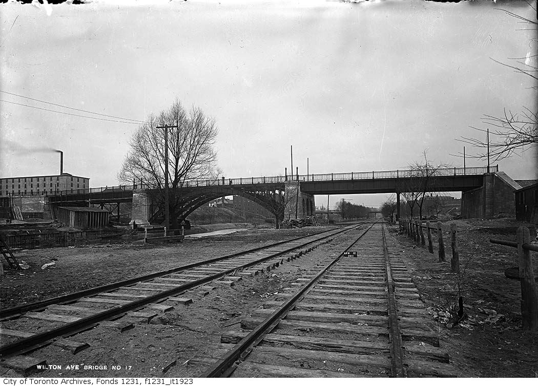
East of Yonge Street, Wilton Avenue was extended across the Don River in 1911, extending just east of Broadview Avenue, incorporating Elliot and Crawford Streets. Though the new bridge was built with streetcar tracks and overhead poles, through service did not begin until 1923, as part of a major TTC route restructuring.
By 1920, Wilton Avenue was renamed Dundas Street East, though the through connection across Yonge Street was not completed until 1922, with the block long section east of Yonge left over from the realignment renamed Dundas Square.
Though the early extensions of Dundas Street through the city simplified the street grid and allowed for through streetcar service between West Toronto and Broadview Avenue, the eastern extension built in the 1950s was done entirely for the benefit of the automobile.
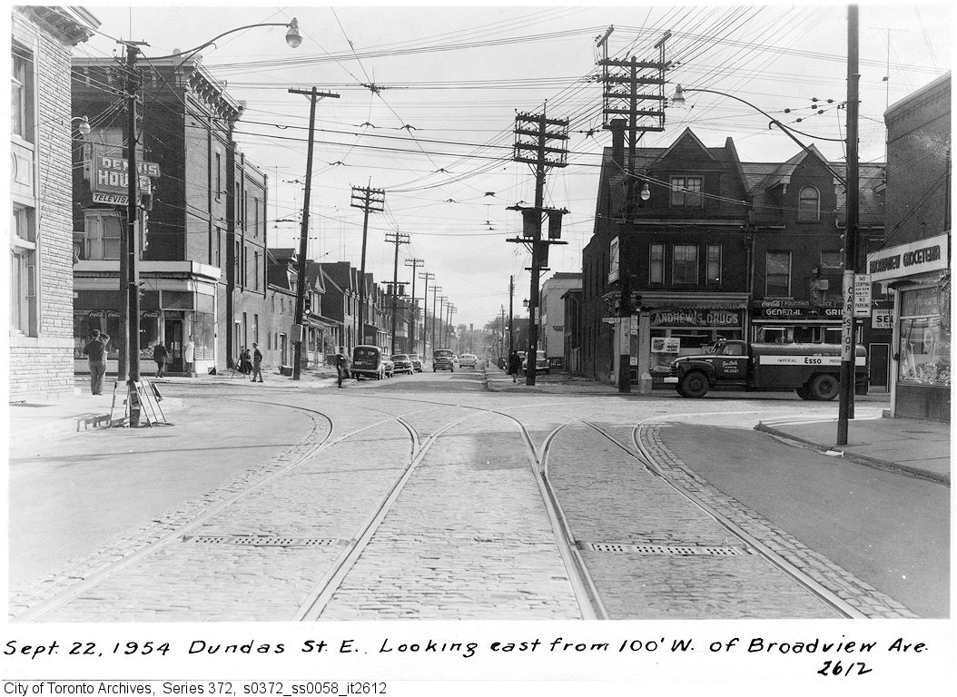
Though Dundas Street extended east of Broadview for one block to Boulton Avenue, it was as a narrow residential street, and did not continue beyond (this is why the Harbord Streetcar took a convoluted route via Dundas, Broadview, and Gerrard to get to Carlaw and Pape Avenues). New roadways were planned to expand traffic access to Downtown Toronto from the burgeoning suburbs, including a new extension of Dundas Street east to Kingston Road.
From Boulton Avenue, a new alignment was built east to Pape Avenue, resulting in the demolition of over a dozen houses on Boulton Avenue, De Grassi Street, West Avenue, and Wardell Street, before ducking under the Canadian National mainline in a new underpass built in 1953, and through an industrial area, avoiding major factory buildings.
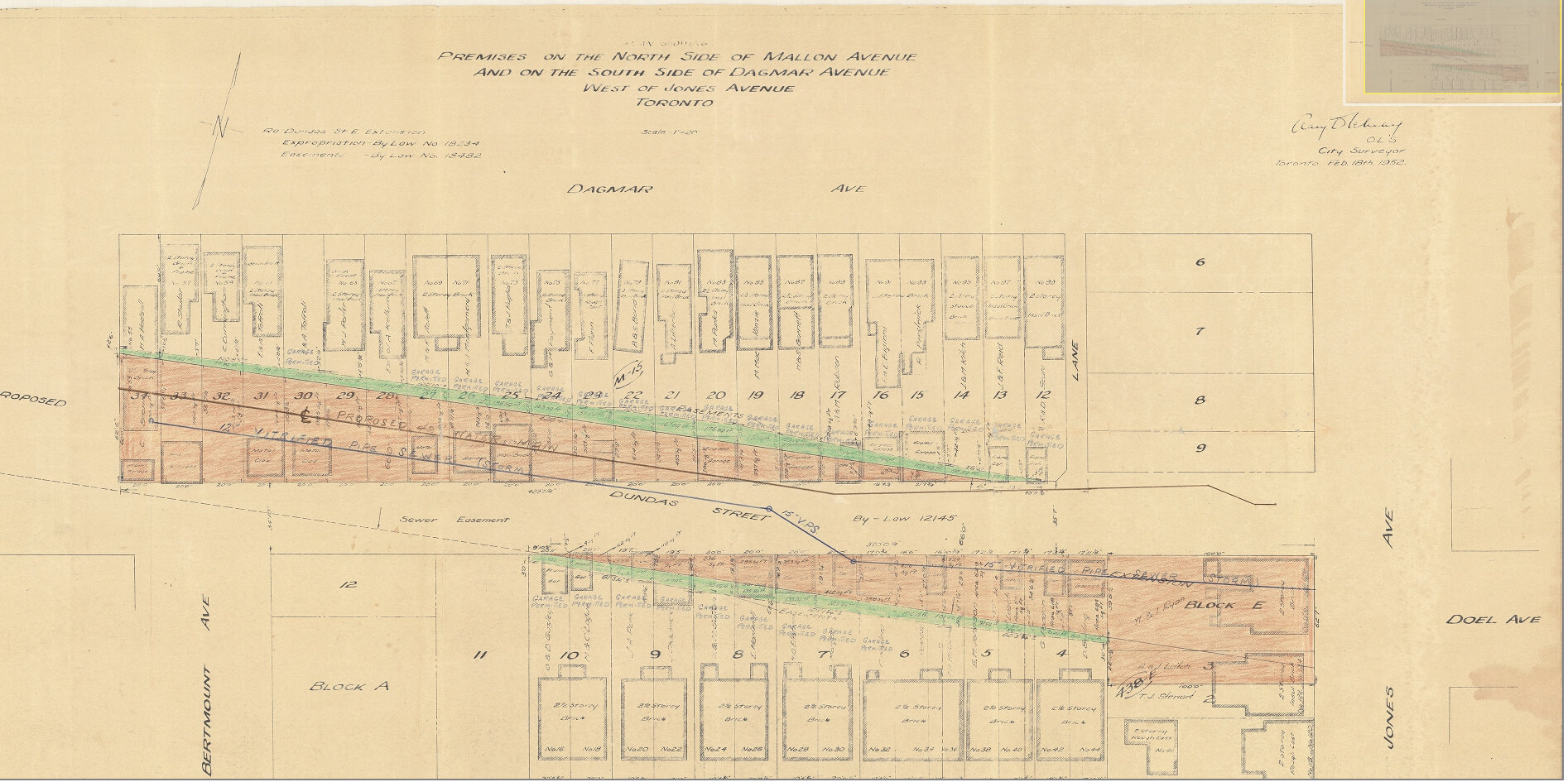
East of Pape Avenue, the new roadway followed a widened Dagmar Avenue, before bending south though a former alley to Jones Avenue to connect with former Doel Avenue to Alton Avenue. Between Alton and Woodfield Road, another new section of roadway was built, through an old brickyard in the late 1940s, connecting with Applegrove Avenue to Coxwell Avenue. The final section, between Coxwell Avenue and Kingston Road, was built through a minor ravine, connecting with, and replacing part of, Maughan Crescent and Edgewood Avenue.
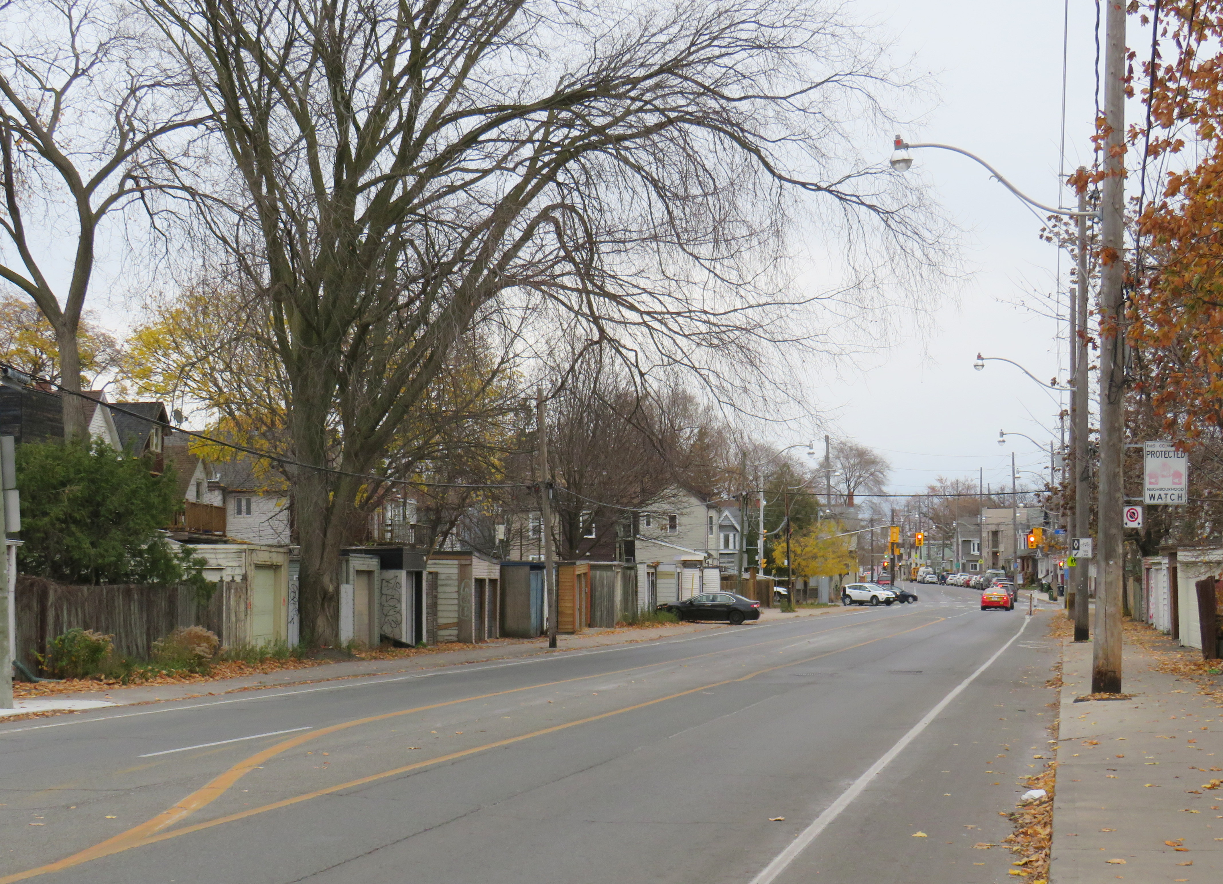
Plan for Dundas Street extension through the rear yards and laneway between Dagmar and Mallon Avenues. From City of Toronto Archives, Fonds 200, Series 2277, Item 32.Just west of Jones Avenue, Dundas Street East is lined with garages, as it passes through an old alley between Dagmar and Mallon Avenues.
Though Dundas Street East was shoehorned into several east-end neighbourhoods through the 1940s and 1950s to provide a new route for automobile traffic, over fifty years later it became an important cycling route. In 2003, the speed limit was reduced to 40 kilometres per hour, and the four traffic lanes reduced to two, with new bike lanes and a centre turning lane. Without streetcar tracks (unlike neighbouring Queen and Gerrard Streets), and with few storefronts, Dundas Street was simple to reconfigure. In 2020, the bike lanes were extended west across the Don River and into Regent Park, as part of the new ActiveTO measures.
Within Toronto, Dundas Street has gone by many names: Arthur, St. Patrick, Anderson, Agnes, Wilton, Elliot, Crawford, Dagmar, Doel, Applegrove, Maughan, and Edgewood. At various times in the first half of the last century, city officials have decided to change their names to Dundas Street.
It would not be without precedent to change Dundas Street’s name as well. Henry Dundas has no connection to local history, and even the historic road that bears his name did not extend any further east than Ossington Avenue.
Retain the legal street names with additional interpretation and recognitions
Retain the legal street names but rename those civic assets with Dundas in their name, except TTC facilities (there are three parks and one library branch that include the Dundas name, and Yonge-Dundas Square; there are two TTC subway stations and one streetcar line that also bear the Dundas name)
Rename the streets and all other civic assets now carrying the Dundas name (including Dundas Street East, Dundas Street West, Dundas Square, and Old Dundas Street).
I would agree with at least the third option, and likely the fourth option, even in part. As one of the city’s most famous and popular meeting places, a better name can be found for Yonge-Dundas Square. As Dundas Street East is a 20th century construct, and less than half the age of the historical road, it too, would be a great candidate for renaming to something meaningful. There are many other streets, towns, and parks in Toronto and elsewhere in Ontario that carry names given by early colonial officials, eager to leave their mark on newly claimed lands. Some are also worthy candidates for renaming.
Other municipalities, including Mississauga, Oakville, Burlington, Woodstock, and London, will also have to decide what they will do with their sections of Dundas Street. There is also the matter of the former Town of Dundas, the Dundas Valley, the United Counties of Stormont, Dundas, and Glengarry in Eastern Ontario (and two townships within it). There are also Dundas Streets in Belleville, Trenton, and Napanee along Highway 2, but otherwise unrelated to the historic road.
But the process must be thoughtful and considerate, and not just a another feel-good exercise that distracts from the real economic and racial inequities in our city.
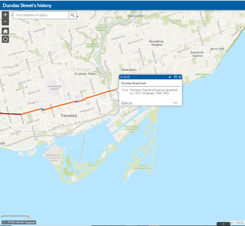
The interactive map below illustrates the history of Dundas Street, from London to Kingston Road.
Update December 14, 2020: With outdoor skating rinks fully opened for the season, I have added the washrooms located at each of these facilities open this winter. Though many rinks will have to be pre-booked to use (to limit crowds during the pandemic) the city has provided access to adjacent indoor washrooms. I also noted the addition of a portable toilet at Guild Park, something I commented on previously.
Please note, though, that many portable toilets have not been kept in good service. I suggest bringing hand sanitizer on your walks in case you need to use one of these temporary facilities.
Update November 28, 2020: I have added the list of 51 temporary portable toilets that the city has or will be adding to its parks this winter as part of an effort to encourage Torontonians to get outside for winter walks. Many of these locations are along the major ravine paths, including the Don and Humber Rivers. Most location descriptions were easy to locate, though others were quite vague. I did the best I could with the information given. I also added the toilet locations at Tommy Thompson Park, which is operated by the Toronto and Region Conservation Authority.
There remain some critical gaps, including the absence of Guild Park in Scarborough and along the waterfront between Humber Bay Shores and Marie Curtis Park, but on the whole, this is a positive development. The city also announced new winter maintenance of additional park paths, though ideally, this service would be extended along the entire ravine network.
As of Monday, November 23, Toronto and Peel Region will be in another lockdown. Non-essential businesses and services will close or be open only for take-out and curbside pickup. Gyms, patios, and salons will all be closed. Though we may not be able to socialize with friends and extended family, we can still go for walks, runs, and bike rides to maintain our physical and mental heath.
But with indoor dining prohibited since October in Toronto, and most malls closing down, finding a washroom has become much more difficult. Many outdoor park washrooms are not winterized, so they must close as well. For many of us, having access to open and accessible washrooms is a necessary when leaving the home for long periods of time.
Though there is a list of washrooms open (or soon to open) on the city’s website, they are listed in alphabetical order, without easily-accessible location information. I took the liberty of mapping each park washroom location, as well as selected other city-owned public washrooms accessible seven days a week.
Though winterized public washrooms can be found across the city, there are a few areas left unserved, including the Etobicoke waterfront between Humber Bay Shores and Long Branch, the eastern Scarborough waterfront parks, including Guild Park and the Port Union/Rouge Beach area, and northwestern Etobicoke. Ideally, every Torontonian should live within walking distance of a four-season park.
Even with the impending lockdown, there are some other washrooms that will remain available when necessary. GO Transit has kept washrooms at its stations accessible even during the Spring 2020 lockdown. On the Lakeshore Line, stations are open seven days a week, including Guildwood and Rouge Hill. Many supermarkets have public washrooms as well.
I hope that there will be improved four-season access to public washrooms this year, and every year going forward. Simple outdoor activity, including long walks, are one of the safest and easiest things we can do to keep ourselves happy and busy.
I will update the map as more washroom facilities open.
Parks across Canada are closed, with the exception of walking through
On Saturday April 11, during the Easter long weekend, the City of Toronto announced that a team of over 350 police officers and bylaw enforcement officers would shift from an education-based campaign of verbal and written warnings to people congregating and using closed amenities in parks to a zero-tolerance ticketing campaign. Tickets for violating orders — intended to slow the spread of COVID-19 — include a fine of up $1,000.
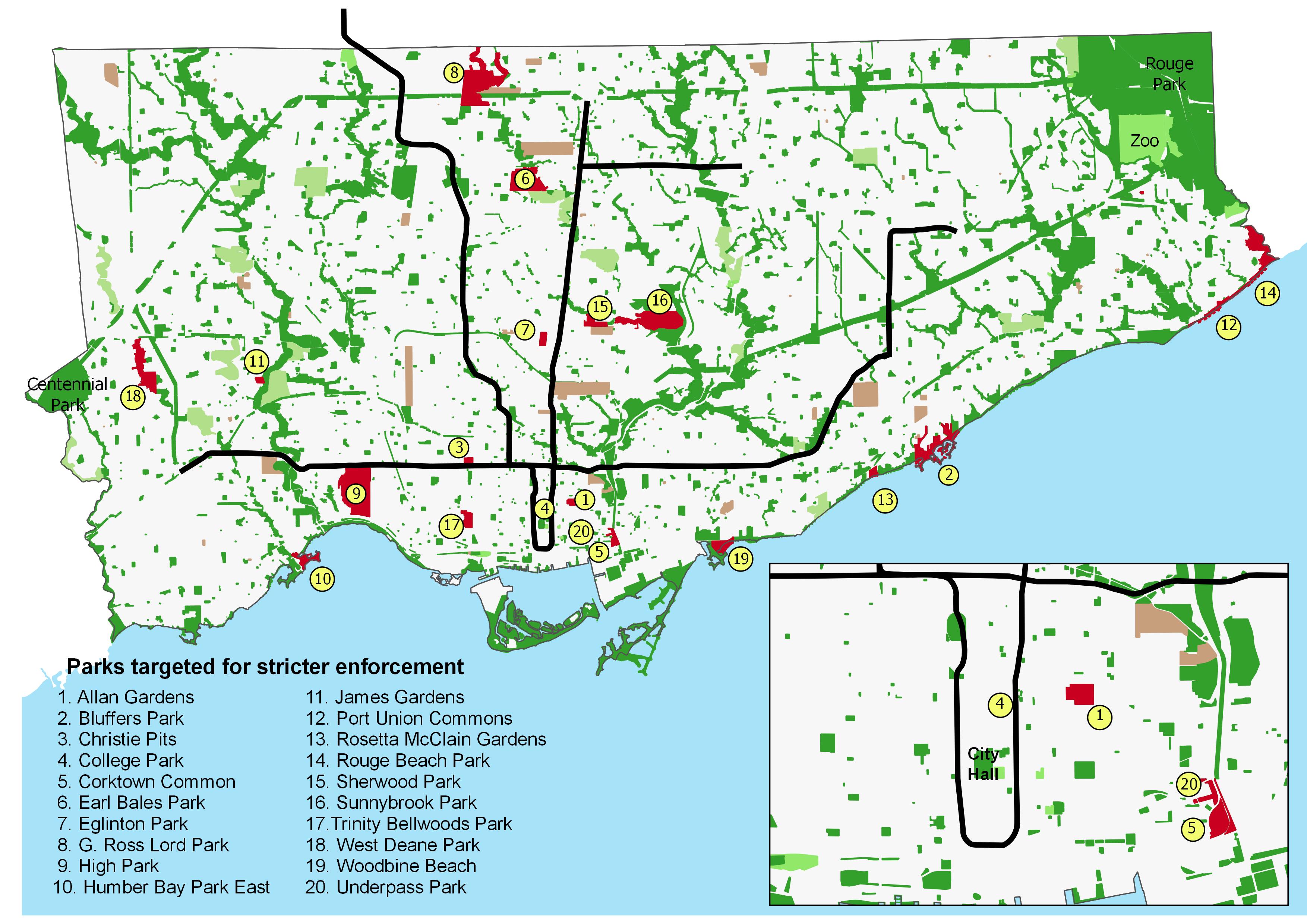
In the press release, the city listed twenty parks specifically targeted for enforcement. Though most are located in the old City of Toronto and along Lake Ontario, there are several others located in Toronto’s inner suburbs.
The list of parks include several along Toronto’s waterfront, including Humber Bay Park, Woodbine Beach, and Bluffers Park. It also includes several small downtown parks adjacent to recent high rise residential development, including Corktown Common, College Park, and Allan Gardens. Large suburban parks known for family gatherings and picnics, such as Earl Bales, G. Ross Lord, and Sunnybrook Parks are also on the list.
These parks are illustrated in the map below.
Parks targeted by the City of Toronto for stricter enforcement (click for larger image)
Though many of us are at home, working remotely or waiting for schools and workplaces to reopen, those employed in essential industries and services do not have a choice. For the rest of us not required to self-isolate, an occasional walk or bicycle ride is good for our mental and physical well-being. It may be necessary to pick up food and prescriptions.
For those of us without yards and quiet residential neighbourhoods, going outside means either navigating narrow and occasionally crowded sidewalks, or going to nearby small and busy parks, especially those without access to a car. In my experience so far, the vast majority of people are respecting the calls for physical distancing.
Closing parking lots and amenities such as playgrounds and picnic facilities makes sense. Where possible, we shouldn’t be straying far from home while physically distancing, and we should be keeping close to those we’re living with. Meanwhile, tens of thousands of people live in apartments in Mimico and Humber Bay Shores; they shouldn’t be crowded out of their own backyard by others seeking a stroll along the waterfront.
But downtown and in the Yonge-Eglinton area, quiet open spaces close to home may be hard to come by. Sidewalks are narrow, construction barriers such as scaffolding make physical distancing especially difficult, and along Eglinton Avenue, Crosstown LRT construction has made getting around on foot especially challenging, with pedestrians often restricted to narrow passages.
These help to explain the problems at College Park, Eglinton Park, and Allan Gardens. Furthermore, Allan Gardens is close to several shelters and social services such as Seaton House, and has long been a place for marginalized residents to socialize and linger.
This was the argument made by two associate professors of epidemiology at Ryerson University, who sent an open letter to Mayor John Tory and the city’s medical officer of health, Eileen de Villa, arguing for more road space for pedestrians and cyclists.
While most people are urged to stay home as much as possible during the ongoing COVID-19 pandemic, there are those who must carry on. These include health care workers, staff at grocery stores, pharmacies, and other essential businesses, and others who can not work from home. There are also those who continue to require transit to undertake essential errands, such as medical appointments.
Thankfully, most transit systems have carried on. Through GO Transit has experienced an 80% drop in ridership since the beginning of March, it continues to operate all rail lines and most bus routes, providing fewer trips, but maintaining the same span of service hours. The TTC discontinued most express routes, but it maintains a grid of frequent bus and streetcar services.
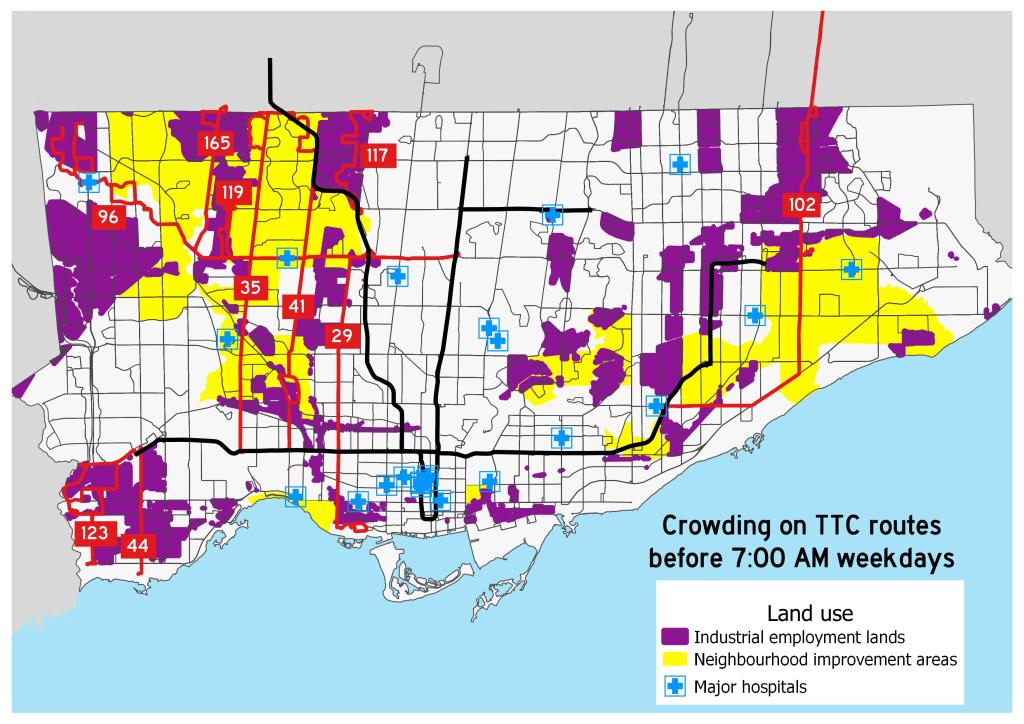
However, the TTC and Brampton Transit continue to struggle with crowding on certain routes. Brampton Transit — which has resorted to an “enhanced Saturday service” level –will only carry half a bus’s seated capacity to enforce social distancing, which has resulted in “closed-door” situations where buses won’t stop for waiting passengers. As a result, several routes are now discontinued during peak periods so that buses are sent to address crowding elsewhere. Brampton Transit serves many shipping warehouses, including two Amazon fulfillment centres, which remain busy during this time.
Routes 117 and 119 are industrial services, connecting warehouses and food service plants. These industries — like the infamous Fiera Foods plants served by Route 119 — rely on low-paid, often temporary workers, with early morning starts. Certain warehouses and many food-service plants also have very early starts to the day. It would be tough for workers to accommodate the TTC’s request to travel at later times. Routes 96, 102, and 165 also extend into major industrial areas. Route 123 serves the Metro supermarket chain’s distribution centres on Dundas Street and The West Mall.
Many of these routes run through Toronto’s neighbourhood improvement areas, which are identified by the city as those requiring additional investment due to issues such as poor access to services and higher concentrations of low-income families. In addition, routes 41, 96, 119, and 165 serve the Humber River Regional Hospital, one of Toronto’s largest health care facilities, while the 96 Wilson also directly serves Etobicoke General Hospital.
Though it would be best for private essential employers to stagger shifts during this unprecedented time, there may be a need for the TTC to redirect some resources towards these parts of the city.
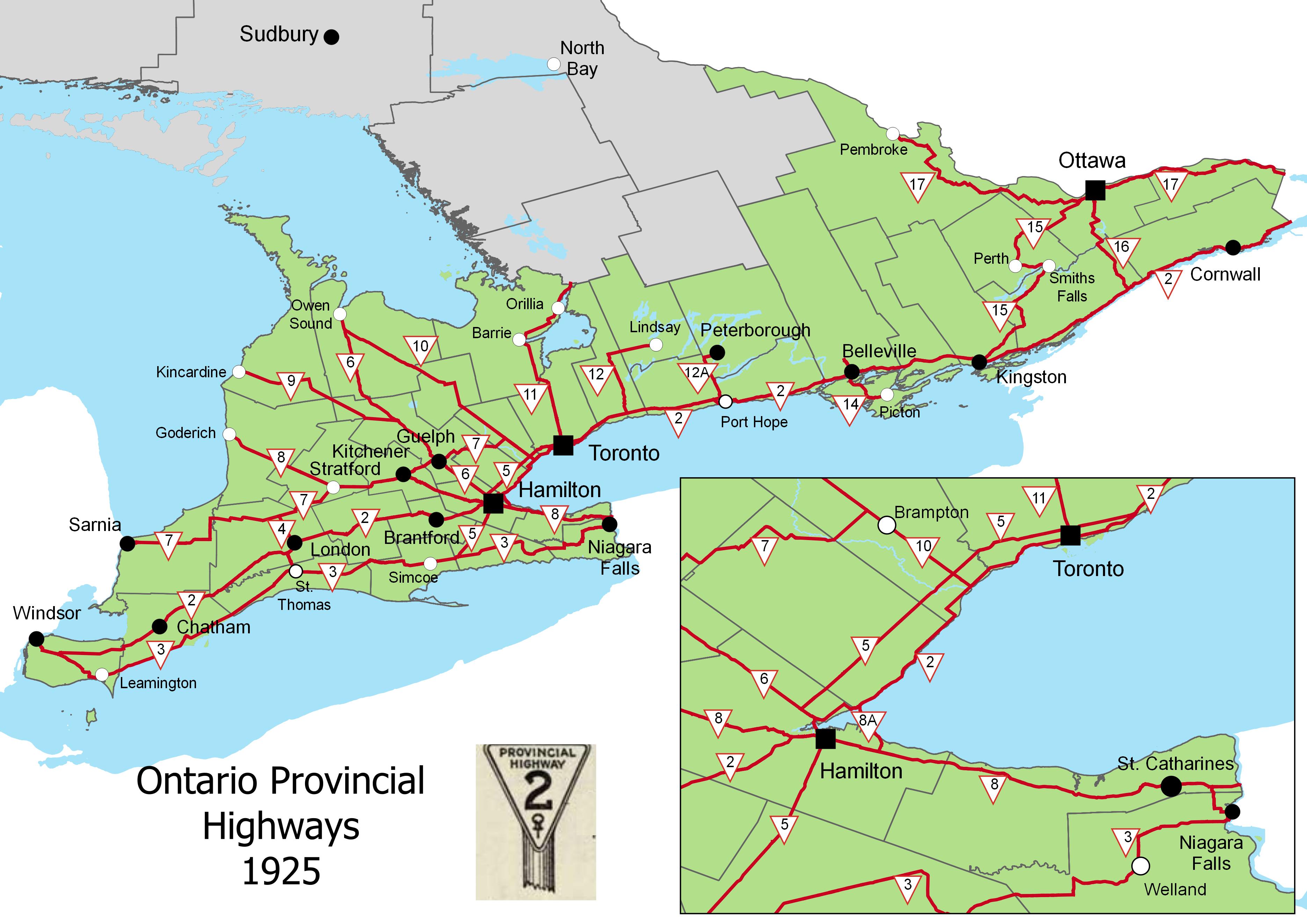
On February 26, 1920, Ontario’s provincial highway network was born. That year, 16 highways were established across southern Ontario, between the Ottawa and Detroit Rivers. These highways, previously maintained by townships and counties, connected the province’s largest cities and provided important links to Quebec and the United States.
In 1925, these highways were assigned numbers 2 through 17, in rough order from west to east. There was no Highway 13; instead, the Port Hope-Peterborough Highway was assigned Route 12A. Highway 2, alternatively known as the Trans-Provincial Highway, extended from Windsor to the west to the Quebec border in the east, continuing eastwards as Quebec Highway 2. (That province renumbered its entire highway system in the 1960s and 1970s.) Meanwhile, Highway 15, connecting Kingston and Ottawa, took a deviating “S” shaped route via Perth. Highway 7 only went as far east as Brampton. While the province used triangular highway markers at the time, in 1930, they were renamed “King’s Highways” and assigned crowned highway shields still in use today.
The map below illustrates the highway system at the time.
Several of Ontario’s first highways no longer exist. Highway 12A was later renumbered to Highway 28; that first section was later downloaded to Northumberland and Peterborough Counties. The first section of Highway 14, which originally ran between Foxboro and Picton via Belleville, was later integrated with the longer and more important Highway 62. The short stub of Highway 14 between Foxboro and Marmora was also downloaded in the 1990s.
Four years ago, I wrote about GO Transit’s problematic fare structure. Though GO Transit claims to charge passengers based upon a fare-by-distance structure, fares for travelling short distances were disproportionately high compared to long-distance rides from outer suburban stations. In 2015, I also found significant fare differences between corridors, with Kitchener Line passengers paying the most per distance traveled.
Since my original post, some changes were made to the GO Transit fare system:
In 2016, a tiered fare increase was applied, with the lowest fares frozen (for example, Union Station to Mimico, Bloor, or Danforth), with fare increases between 40 and 60 cents per ride dependent on distance traveled. Those fare increases applied to Presto fares, though with a discount (11.15% less than the cash fare).
In January 2018, a $1.50 fare discount was introduced for Presto card users transferring between TTC and GO. However, the Ford government announced it would no longer subsidize the TTC-GO fare discount, threatening its continuation.
In April 2019, GO fares for trips less than 10 kilometres were reduced, with the minimum cash fare going from $5.30 to $4.40, with the minimum Presto fares reduced from $4.71 to $3.70. A passenger headed from Union Station to Exhibition Place could choose to take a local TTC streetcar fare ($3.10 with a Presto Card) or the direct GO train ride (just 60 cents more). At the same time, the cash fares for trips longer than 10 kilometres were increased by 4%, while Presto fares were increased by 3%.
The good news is the eventual reduction of short-distance fares have gone a long way towards flattening the fare/distance curve.
There were also some major service changes over the last four years. Two new GO stations were opened: Downsview Park (which offers a direct connection to the new TTC subway extension to York University and Vaughan), and Gormley, a station built next to Highway 404 on the Oak Ridges Moraine. Additional trains were added to Kitchener, new peak-period trains to and from Niagara Falls were introduced, evening trains added on the Kitchener Line, and this month, weekend trains were introduced on the Stouffville Line. But connecting bus routes to Cambridge, Bolton, and between Milton and Oakville were eliminated, with other bus trips cancelled across the system. (more…)
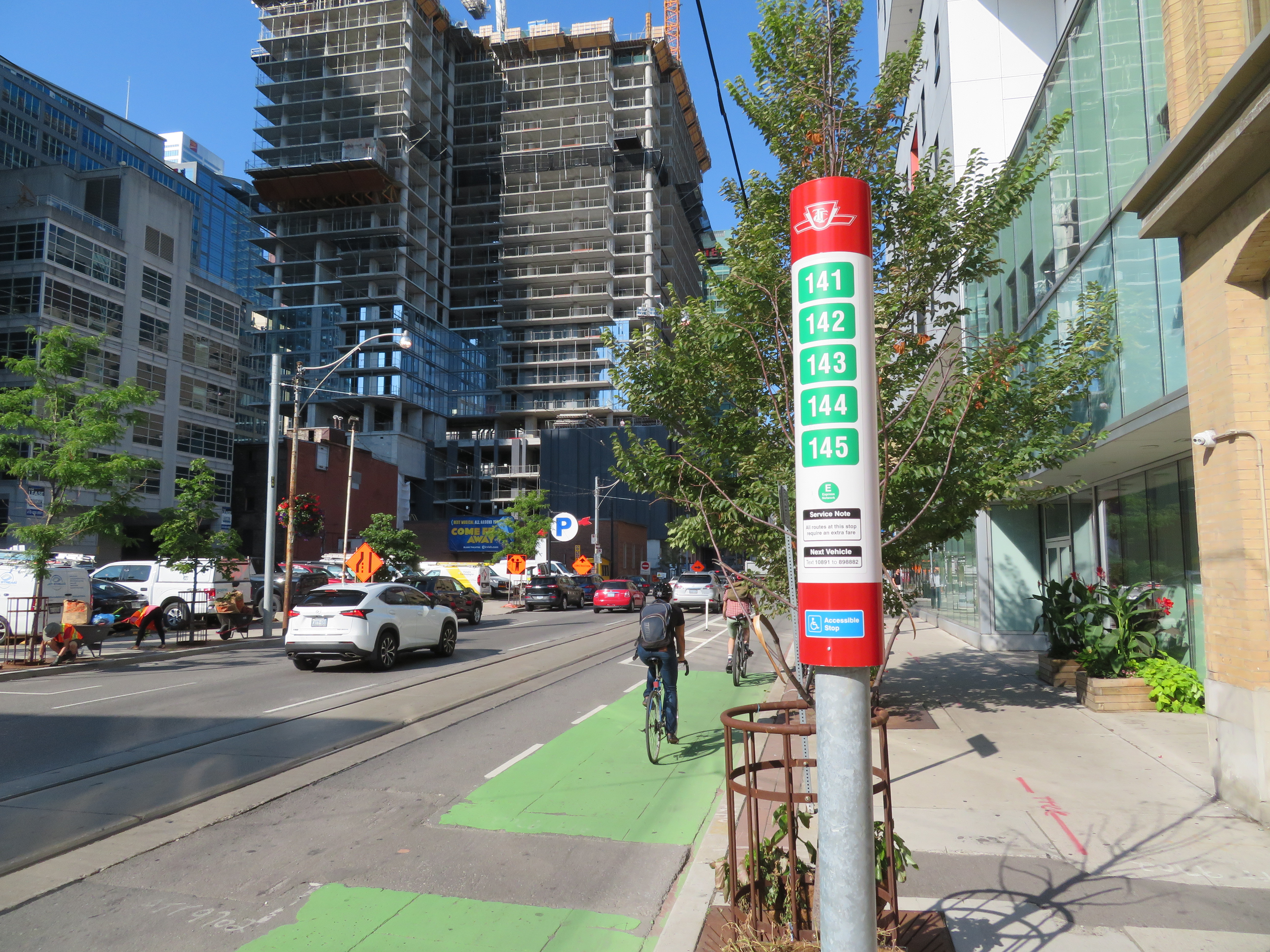
TTC stops have improved with the addition of route numbers, but this bus stop is deceiving
In the last few years, the TTC has made significant improvements in its maps, signage, and wayfinding standards. It also introduced new streetcar and subway fleets, retrofitted elevators into older stations (all but one streetcar line and a majority of subway stations are now fully accessible), and opened a new subway extension. Though overcrowding, bunching, and weekend closures continue to be aggravations, it is important to recognize where the TTC has improved.
Specific changes to TTC wayfinding include a new simplified system map, better signage at subway stations, introducing standard signage for diversions, scheduled closures and construction notifications, and revising the classic TTC bus stop.
However, two recent changes represent an unfortunate departure from these improvements. (more…)
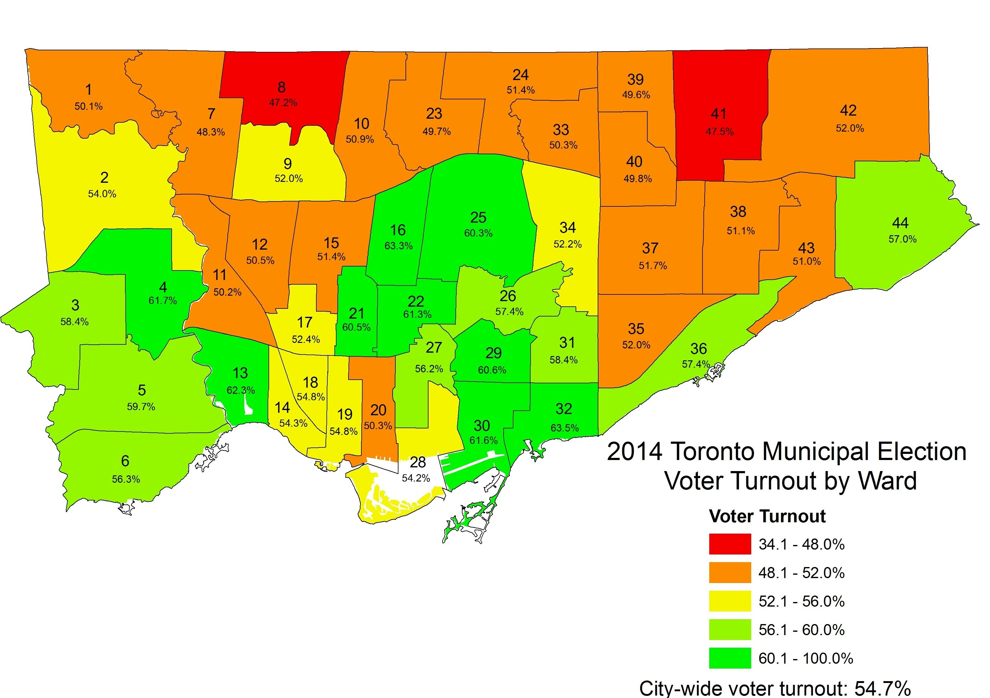
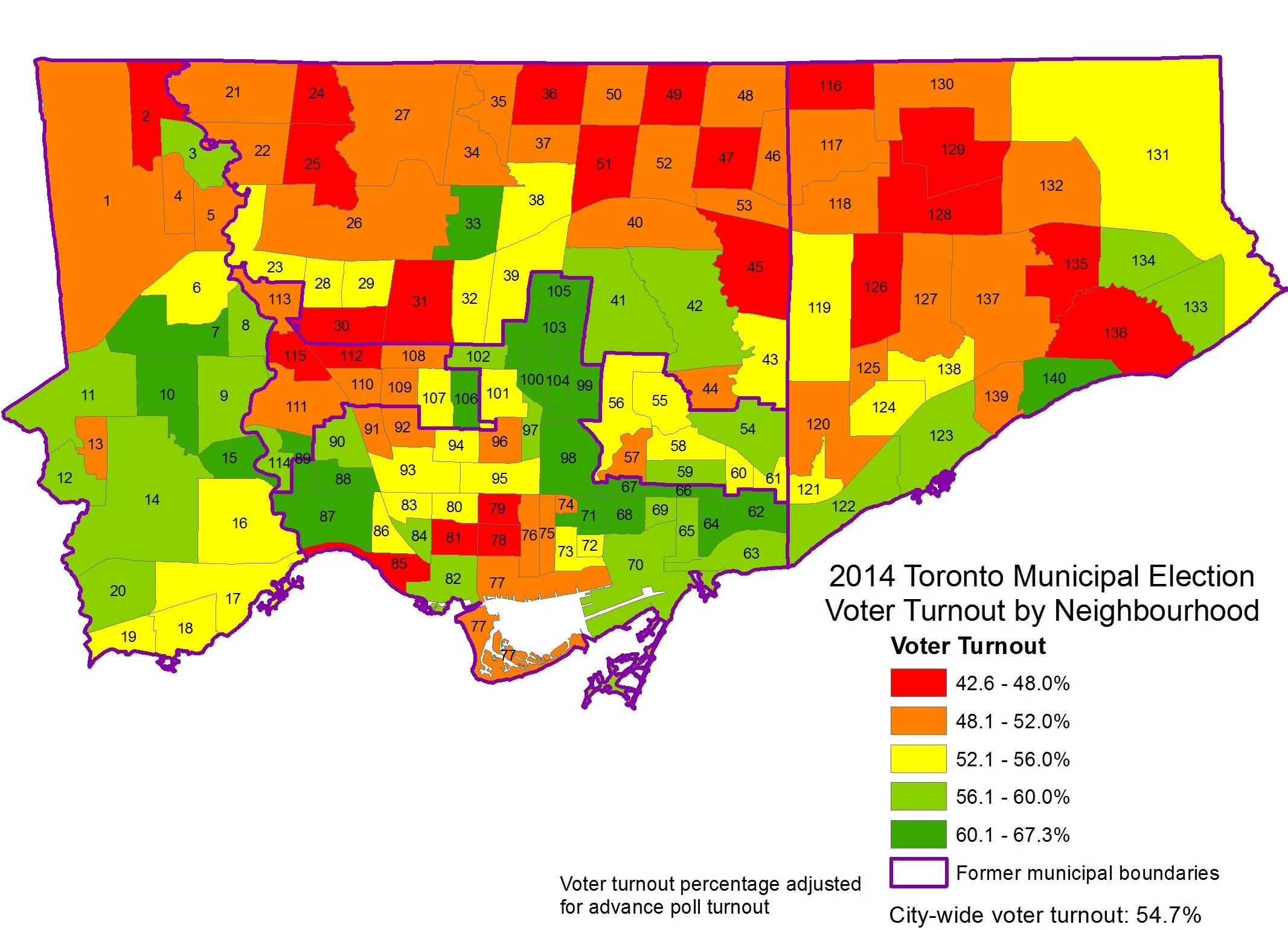
2014 was a watershed year for municipal voter turnout in Toronto. After a disastrous four years of Rob Ford as mayor, 54.7 percent of all eligible voters went to the polls, electing John Tory. That was the highest voter turnout in decades, even higher than 1997, when Torontonians elected Mel Lastman to lead a newly amalgamated City of Toronto. In 2010, when Rob Ford was elected mayor, turnout was 50.4 percent, compared to 39.3 percent in 2006 and 38.3 percent in 2000.
Four years ago, the mayoral race was especially competitive. Progressive Olivia Chow was the initial front-runner against Ford, but Tory (who previously ran for mayor in 2003) pulled ahead as Chow’s campaign floundered. Late in the campaign, Rob Ford dropped out due to health concerns, so his brother Doug took his place. Among the three frontrunners, Tory got 40.3 percent of the vote, while Doug Ford took 33.7 percent. Chow only got 23.1 percent. Voters also elected seven new councillors that year, and returned Rob Ford to Ward 2.
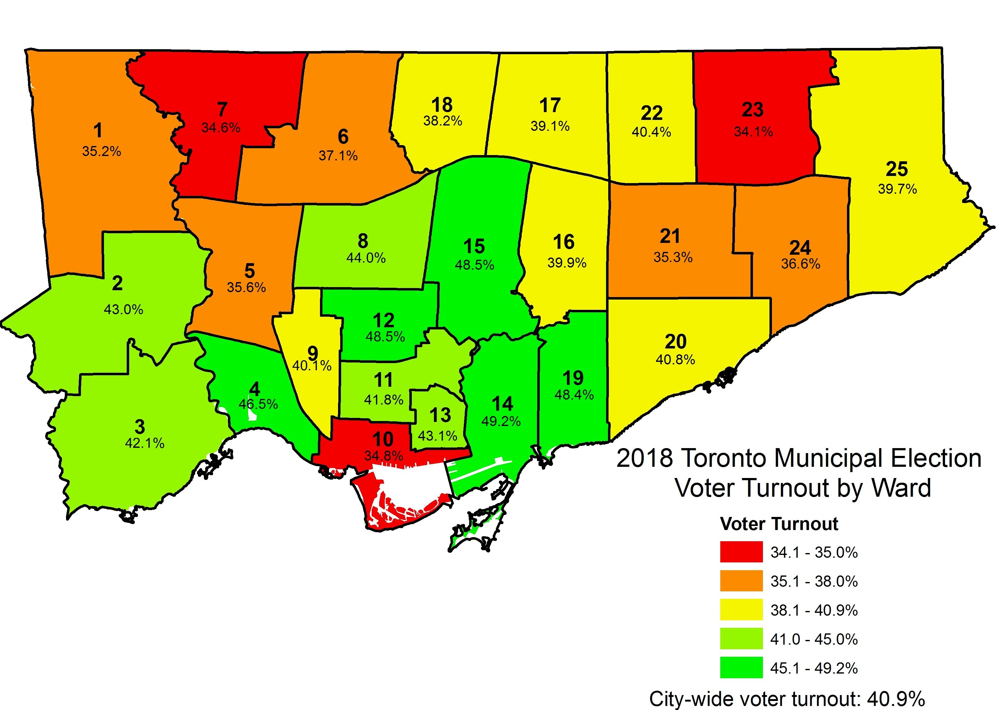
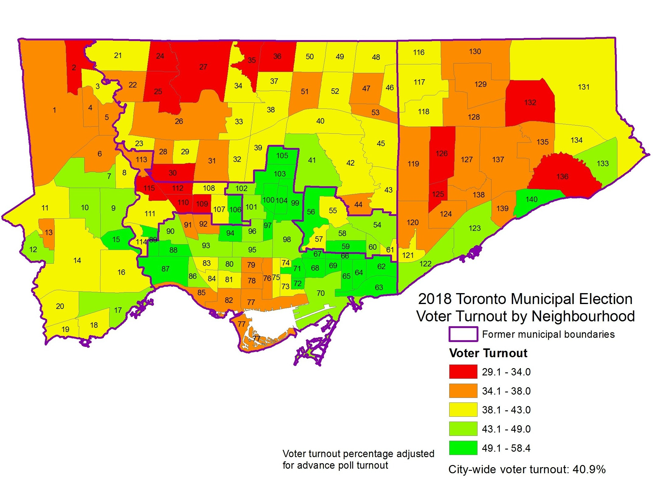
After two elections in which over half the number of eligible voters took part, in 2018 voter turnout fell to just 40.9 percent. This was hardly surprising. John Tory cruised to victory despite a challenge by former chief planner Jennifer Keesmaat, while a sudden reduction in the number of wards confused voters and crushed the hopes of many council hopefuls and their supporters.
Though 769,000 electors voted in this mess of an election, voter turnout varied across the city. In Ward 23, Scarborough North, only 34.1 percent of eligible voters turned out to the polls. In Ward 7, Humber River-Black Creek, just 34.6 percent of electors voted. Ward 10, Spadina-Fort York, had the third worst turnout, with just 34.8 percent.
Areas with the highest voter turnout were Midtown and east end Toronto. Ward 14, Toronto-Danforth had the highest turnout, where 49.2 percent of electors cast a vote. It was followed by Ward 15 and Ward 12 (both of which had 48.5 percent turnout) and Ward 19, where 48.4 percent of electors went to the polls.
Wards 12, 14, 15, and 19 had interesting and competitive council races. In Ward 14, the race featured two progressive incumbents, while Ward 19 was one of just two races in which an established city councillor was not running for re-election. Wards 12 and 15 also had competitive races. However, in Ward 4, Gord Perks won re-election easily.
Yet Ward 23 had an open council race in which no incumbent was running. And Ward 7 was one of the most interesting and important races of 2018; this is where Giorgio Mammoliti was finally defeated after years of campaign violations, buffoonery, and embarrassments.
Voter turnout has consistently been low in Toronto’s northwest and northeast corners. In 2014, Ward 8 and Ward 41 (which made up parts of new Wards 7 and 23) had the lowest numbers of electors casting a vote. Turnout was highest in more affluent neighbourhoods, especially in places like Midtown Toronto, the Kingsway neighbourhood in Etobicoke, and in Toronto’s East End. What surprised me mostly was the poor turnout in Ward 10 in 2018.
The difference in voter turnout across the city is more apparent at the neighbourhood level. With the poll-level results available through Toronto’s Open Data Catalogue, I allocated the poll results to each of Toronto’s 140 neighbourhoods, while adjusting the numbers based on the number of votes cast in the advance polls in each ward. The map below shows voter turnout at the neighbourhood level in 2018.
What is immediately apparent is that voter turnout is highest in many neighbourhoods surrounding Toronto’s downtown core, while turnout is lowest in the former City of York, in northwestern Toronto and parts of Scarborough. Areas of high voter turnout tend to be affluent neighbourhoods with high levels of home ownership. These neighbourhoods include the Kingsway, Lawrence Park, Leaside, Cabbagetown, Rosedale, Forest Hill, Swansea, the Beaches, and Leaside. Many of these areas also have active residents’ associations. With Ryerson professor Myer Siemiatycki, I looked at the results of previous municipal election voter turnouts in a report published by the Maytree Foundation.
Downtown, areas with major condominium developments also have lower turnout, especially in places like the Waterfront, CityPlace, Liberty Village, and the Bay Street corridor. These areas are more likely to have younger residents and many renters. Engaging voters both in downtown condos and those living in the inner suburbs remains a challenge. While voter turnout was much higher in 2014 across the city, the same basic patterns are evident. 2014 voter turnout by neighbourhood (alternate version available here)
At the end of 2014, despite some disappointing results in that year’s municipal election, I was feeling optimistic about 2018. In 2014, there were a number of great candidates running for city council, and I expected many would try again in 2018. After council finally approved the recommended 47 ward model for the 2018 election, I was excited. Downtown, which was badly underrepresented under the 44 ward model, would get three additional wards. Vacancies left by departing councillors, including Mary-Margaret McMahon and John Filion, would further improve the chance for fresh new voices to join city council. At least eight wards across Toronto would not have an incumbent running.
Of course, we all know what happened to that dream.
Downtown tends to elect some of Toronto’s hardest-working and most progressive councillors. They’re hard-working out of necessity: old Ward 27 had the largest population in the city, and all four old downtown wards struggled with pressures caused by massive new development and social concerns, especially as older, affordable housing stock is replaced by new condominiums. (Similar pressures exist in North York Centre and Midtown.)
The last council term
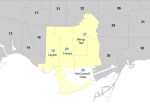
In 2014, four councillors were elected downtown. Mike Layton was re-elected in Ward 19, which ran from Dovercourt Road in the west to Bathurst Street in the east, including Exhibition Place, Fort York, and the Mirvish Village redevelopment site at Bathurst and Bloor. Layton was first elected to council in 2010. Layton is the son of respected long-time councillor and federal NDP leader Jack Layton.
Joe Cressy was elected in old Ward 20, which was located between Bathurst Street and University Avenue, and included the Annex, University of Toronto, the Entertainment District, City Place, and much of the waterfront. The previous elected councillor in Ward 20 was Adam Vaughan, who resigned in 2014 to run in a federal by-election in Spadina-Fort York. He is now the Liberal MP for Spadina-Fort York. A long-time political activist, Cressy is the son of former city councillors Gordon Cressy and Joanne Campbell.
Kristyn Wong-Tam was re-elected in Ward 27, which included Rosedale, Yorkville, the Church-Wellesley Village, Ryerson University, and Moss Park. A local business owner and an advocate for both LGBTQ and Asian-Canadian community issues, Wong-Tam was first elected in 2010.
Pam McConnell was re-elected in Ward 28, which included Cabbagetown, Regent Park, the St. Lawrence Neighbourhood, much of the Financial District, and the Distillery District. She was first elected as a Metro councillor in 1994. She is credited for many local improvements, including the Regent Park redevelopment and the revitalized Berczy Park. Sadly, McConnell died in 2017. She was replaced by council appointee Lucy Troisi in a controversial vote.
The promise of new representation
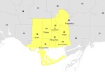
At the beginning of 2018, with three new wards, each of the seven downtown races were starting to shape up.
Mike Layton planned to run for re-election in Ward 19, whose boundaries were similar to the ward he was first elected to in 2010. Joe Cressy planned to run in new Ward 24, and Kristyn Wong-Tam planned to run in Ward 22. Despite her promise not to run for election after her appointment, Lucy Troisi registered to run in Ward 23, against former Liberal provincial cabinet minister and 2010 mayoral candidate George Smitherman. Also running in Ward 23 were Megan Willson, an entrepreneur and community organizer; Khuram Aftab, a local convenience store owner; and Walied Khogali Ali, a progressive community activist in Regent Park and St. Jamestown.
Ward 20 had an especially crowded field of candidates, with eleven council hopefuls. Among the most prominent was local TDSB trustee Ausma Malik, a rising political star. Malik, like other Muslim women and men, faced targeted attacks during the 2014 municipal election. Her win was one of a few bright spots in a nasty campaign season. Malik was backed by many progressives, including Layton and Cressy.
Other high-profile candidates included businessman, transit advocate, and naval reserve officer Kevin Vuong; lawyer April Engelberg; former television journalist and Conservative Karlene Nation; disgruntled restaurateur Al Carbone; second-time candidate Dean Maher, founder of two local neighbourhood associations; and Sabrina Zuniga, federal Conservative candidate for Spadina-Fort York in the 2015 election. Late to register was Han Dong, a local Liberal MPP defeated in the June provincial election. Dong’s entry into the race was supported by former councillor and Liberal MP Adam Vaughan.
Candidates in Ward 21, which encompassed Corktown, the Distillery District, and St. Lawrence Market, included Jennifer Hollett, a former broadcaster and provincial NDP candidate in University-Rosedale; and Suzanne Kavanagh, past president of the St. Lawrence Neighbourhood Association and advocate for local public spaces, including Toronto’s waterfront.
In Ward 25, which included the Yorkville and Church-Wellesley neighbourhoods, there were several well-known candidates, featuring several activists within the local LGBTQ movement. These included Chris Moise, a local Toronto District School Board trustee; Niki Ward, director of the 519 Community Centre; and Ryan Lester, a director of development with the Canadian Centre for Diversity and Inclusion, and former director at Egale Canada.
Downtown voters were spoiled by choice, and there were many worthy and qualified candidates.
But then, of course, Doug Ford seized control of the Ontario Progressive Conservative Party and won the provincial election in June. One of his first acts was to unilaterally cut Toronto City Council to just 25 wards, with the promise to invoke the Notwithstanding Clause of the Charter of Rights and Freedoms to get it past any legal challenge.
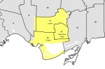
The four downtown wards and their representatives, 2014-2018
The six downtown wards and where each incumbent registered
The three wards under the 25-ward structure, and where each incumbent decided to run. The old four wards highlighted in yellow
Seven downtown wards were reduced to just three. Councillor Joe Cressy decided to run in Spadina Fort-York, while Mike Layton registered in University-Rosedale. Kristyn Wong-Tam ran in Toronto Centre, along with appointed councillor Lucy Troisi.
Many allied progressive candidates, including Ausma Malik and Jennifer Hollett, withdrew their candidacies. Chris Moise decided to run for re-election as TDSB trustee, which he won. Other candidates who withdrew included Han Dong,
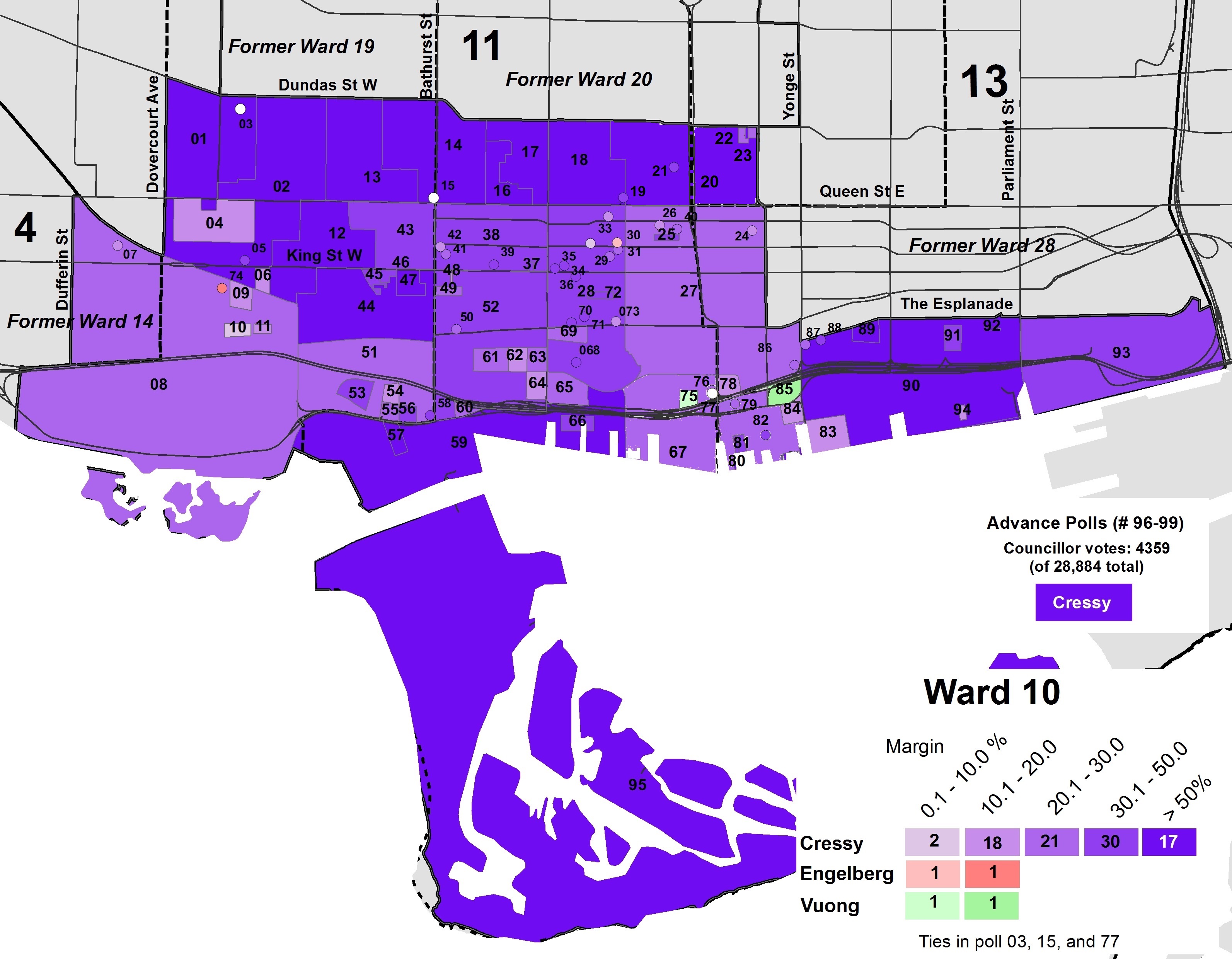
Ward 10
There were 14 candidates running in Ward 10, Fort York-Spadina, including Joe Cressy, April Engelberg, and Kevin Vuong. Cressy won with 55.8 percent of the vote, with Engelberg coming in second place with 11.6 percent and and Vuong with 10.5 percent. Cressy placed first in all but seven polls, most of which were condominium buildings in the Harbourfront and Liberty Village neighbourhoods. The top three candidates all supported the King Street Pilot, while Al Carbone got a mere 1.8 percent of the vote.
Poll results in Ward 10
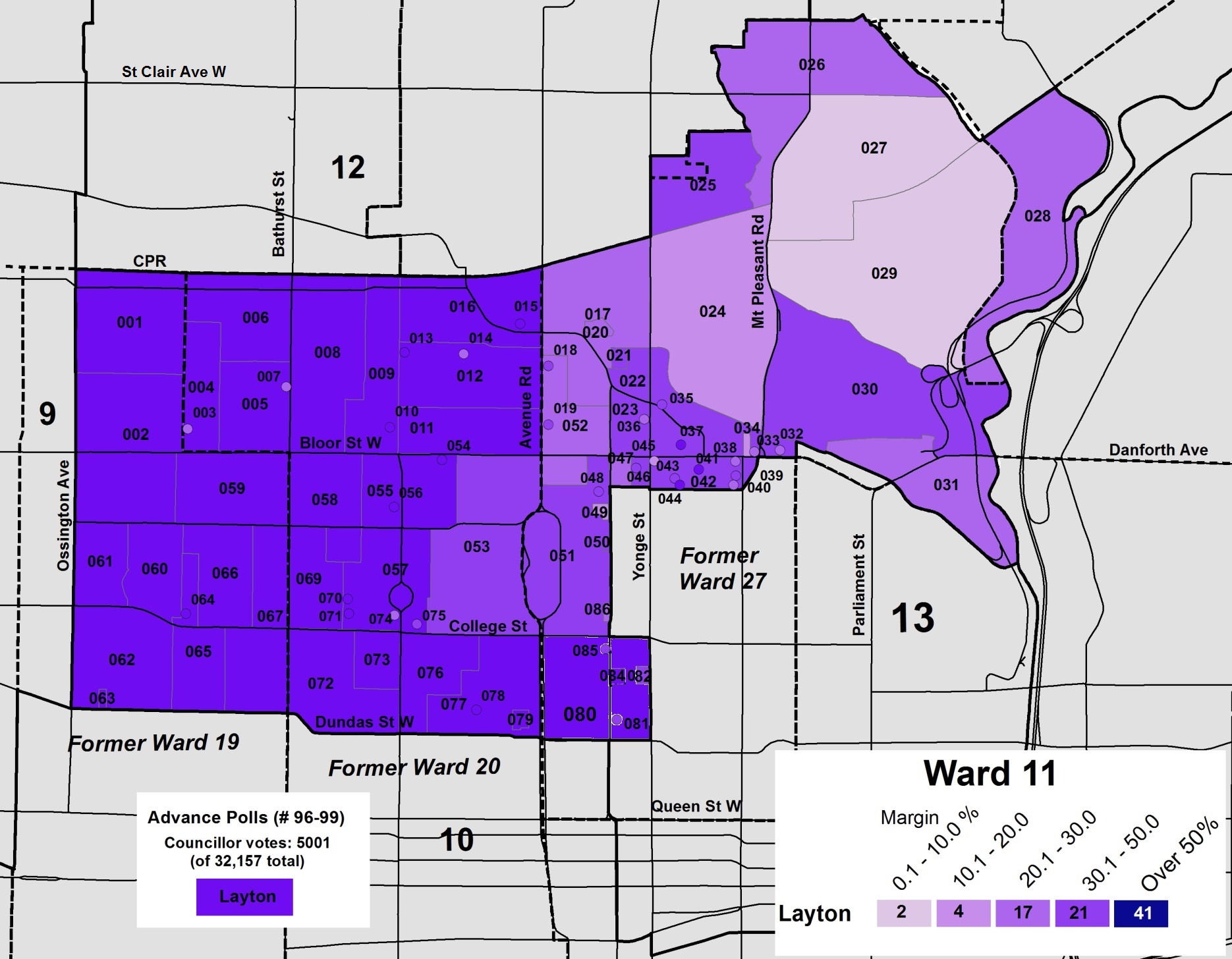
Ward 11
The new Ward 11 was a very different ward from the one in which Mike Layton had run in 2010 and 2014. Only a fraction of old Ward 19 was included in University-Rosedale, which includes neighbourhoods such as the Annex, Yorkville and Rosedale, areas previously represented by Councillors Cressy and Wong-Tam. Layton was challenged by Niki Ward and by latecomer candidate Joyce Rowlands, an occupational health nurse, writer, and policy consultant, and the daughter of former City of Toronto mayor June Rowlands.
Despite the change in ward boundaries, Layton won easily with 69.6 percent of the vote, while Rowlands placed second with 13.2 percent, and Ward in third with 9.1 percent. Layton came first in every poll, but Rowlands did best in Rosedale, almost winning Polls 027 and 029. This was the same area in which Wong-Tam had the least support in 2014.
Poll results in Ward 11
Ward 13
The new Ward 13, Toronto Centre, had much more of former Ward 28 than Councillor Wong-Tam’s old Ward 27. The Rosedale and Yorkville sections of Ward 27 became part of new Ward 11. While Ward 13 is geographically smaller than old Ward 27 (the only instance of this happening under the 25-ward model), it still has a larger population, and has many different challenges than the old ward, as it now includes St. Jamestown, where hundreds remain displaced after a fire, and Regent Park, which is still undergoing redevelopment.
Wong-Tam won with 50.3 percent of the vote, with other high-profile candidates doing quite poorly. George Smitherman got just 15.2 percent of the vote, while Lucy Troisi, the Ward 28 incumbent, got just 8.6 percent. Wong-Tam placed first in all but seven polls, while Troisi didn’t place first anywhere. It’s clear by the poll results map below that Wong-Tam’s support was lowest in St. Jamestown and in the Regent Park neighbourhoods while strongest in old Ward 27 and the area south of Queen Street.
This speaks to the challenges for many councillors elected to new, larger wards. At least Kristyn Wong-Tam is one of Toronto’s most effective and hardest-working councillors, so Ward 13 is in good hands.
Poll results in Ward 13
Conclusion
Downtown Toronto is fortunate to have experienced, dedicated, and hard-working councillors, but concentrating all the work in just three wards is unfortunate. Not only is the population of central Toronto growing faster than most other parts of the city, it has additional needs: an increasing share of the city’s employment that requires additional infrastructure such as a Relief Line Subway, and pressing social needs especially as new development downtown squeezes out affordable rental housing and the institutions that support marginalized people.
I also think of all the great people running for council who never got a fair shot at running for council. Though re-electing Councillors Cressy, Layton, and Wong-Tam is the best result especially considering the circumstances, I was excited by many of the new voices who put their names forward in good faith earlier in 2018. Hopefully, they remain active in the community and get a fair chance in the future.


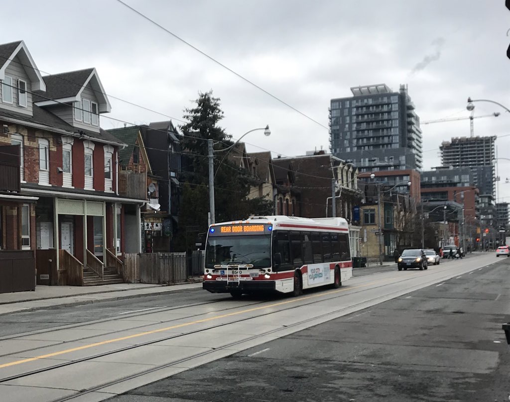 Rear door boarding on TTC buses is just one measure the TTC has taken to address the COVID-19 crisis
 Map of overcrowded early morning TTC routes during the COVID-19 pandemic

 Poll results in Ward 11
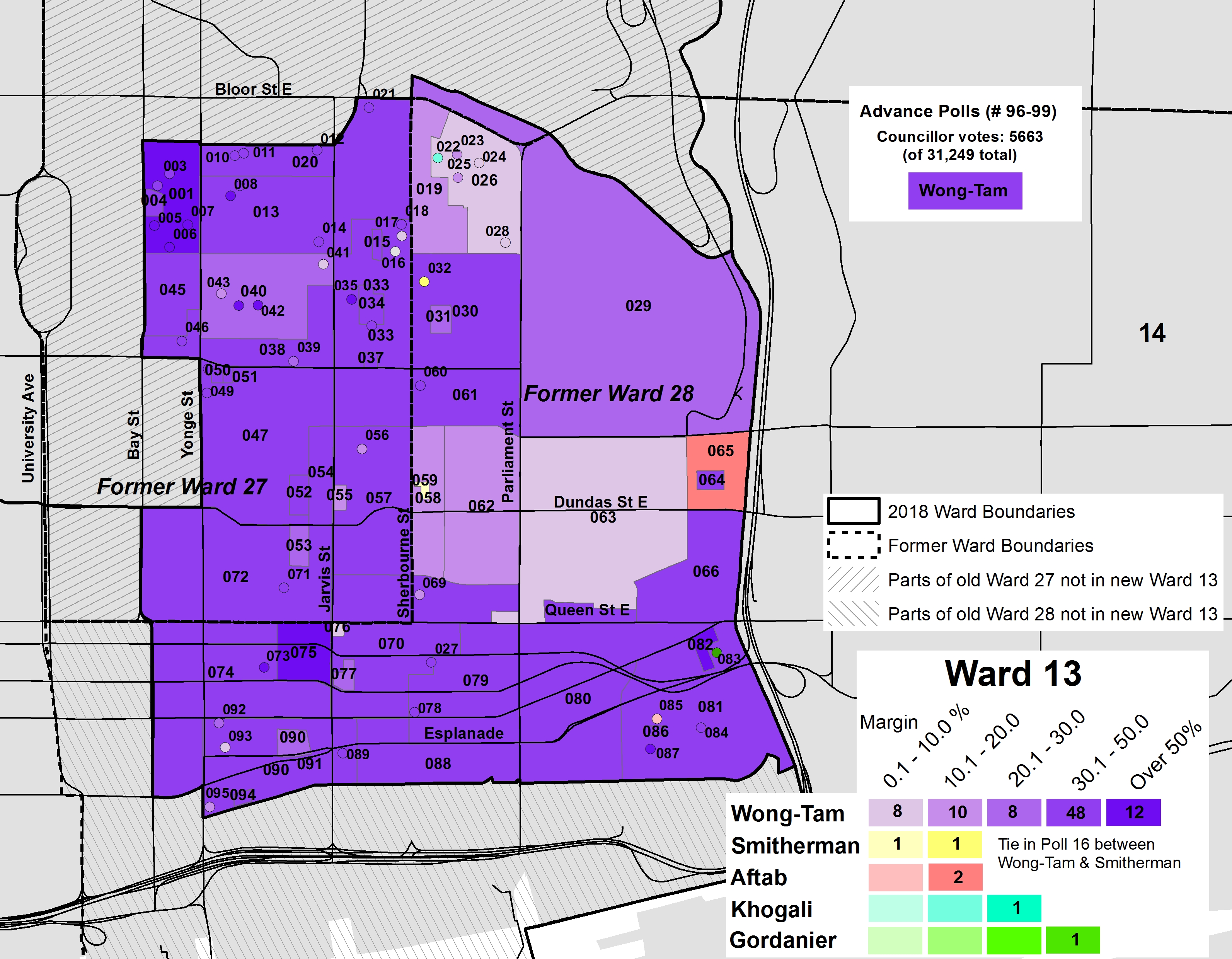 Poll results in Ward 13