Category: Transit

  • What do I know? I’m just a downtown elitist

    23211094949_cd3f8fc6a1_k

    I once described Councillor Denzil Minnan-Wong as the city official that “knew the cost of everything and the value of nothing.” In 2014, Minnan-Wong complained about the costs of building new washrooms at the soccer fields at Cherry Beach, holding up a sign that simply said “$600,000.” That photo of Minnan-Wong, scowling for the cameras, trying to generate some outrage in an election year, was meme gold and so was parodied in the #TOpoli Twittersphere.

    At $600,000, yes the washrooms were expensive. But as they were built in an isolated part of the Portlands, they required a new connection to the nearest watermain; a sewage tank had to be constructed as well, being so far from existing lines. The city has a mandate to provide quality parks and recreational facilities. Minnan-Wong, along with the Fords, also complained about the costs of umbrellas at Sugar Beach, a popular new waterfront park.

    In 2016, under Mayor John Tory’s administration, we have a City that doesn’t know the cost of some things (like the Scarborough Subway) nor does it know the value of other, smaller things, like the Toronto sign.

    The Toronto sign, placed on Nathan Phillips Square ahead of last year’s Pan Am Games proved to be incredibly popular with residents and tourists alike. The LED backlighting allows the sign to be coloured at night to mark any holiday or any important current or special event. The $100,000 climbable sign (reminiscent of the successful “I amsterdam” signs) was supposed to be temporary, and will have to be replaced within three years. A staff report estimate the cost of major repairs to the existing sign, and a new mobile sign, would cost $421,700 over two years. This would be money well spent.

    But some councillors, including Etobicoke’s Stephen Holyday and Scarborough’s Raymond Cho, would rather privatize the sign, perhaps selling it off. At least Councillor David Shiner, a fiscal conservative, called it “a potent symbol of Toronto pride and unity” after amalgamation, but even he questioned the need for paying for city staff to maintain the sign. A strong argument could be made that the costs to maintain the sign should come from Tourism Toronto and the local tourism industry, but calls from some quarters to sell it off are ridiculous.

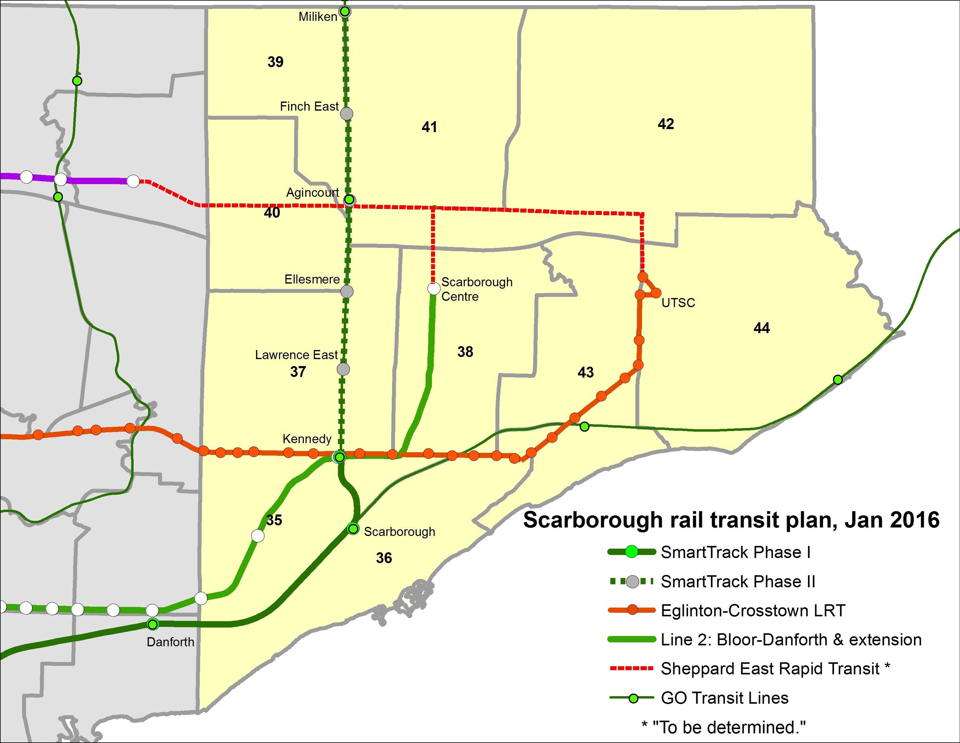
    Last Friday, we learned that the estimated cost of building the one-stop, six kilometre subway extension to Scarborough Centre jumped from $2.0 billion to $2.9 billion. But unlike cycling infrastructure or fully funding an effective Vision Zero program to protect vulnerable road users, the mayor, key council allies, and provincial MPPs remain hell-bent on building it.

    Scarborough Centre MPP Brad Duguid, a powerful cabinet minister in the provincial Liberal government, quoted in the Toronto Sun, said that critics of the subway plan “…have been yapping away on this project from Day 1 and the vast majority of those critics come from fairly elitist downtown views of the city. People in Scarborough and the suburbs of Toronto count as well.” Duguid claimed that “the area surrounding the new [Scarborough Centre] station is growing fast.” Never mind that population and employment densities are not very high along the subway route, even in Scarborough Centre, and no major commercial development has come to central Scarborough since the 1990s.

    On Metro Morning, Duguid, a former city councillor who endorsed John Tory’s mayoral bids in 2003 and 2014, doubled down on his previous rhetoric. He repeated false claims about Scarborough Centre’s growth, claimed Scarborough residents have paid for downtown subway expansions, he even stated that the Scarborough Subway “transcends politics” (which earned a guffaw from host Matt Galloway).

    I live downtown, and I don’t use the subway; like many who live here, I walk to work. Many others cycle, or take overcrowded streetcars on King and Queen Streets. The Yonge Subway is overcrowded from commuters from outside the downtown core. Most downtowners wouldn’t directly benefit from a Relief Line either, but it’s an essential part of the network. The last subway built in Downtown Toronto was in 1966. I’m hardly an “elitist” either; I rent my apartment. I don’t enjoy many luxuries, and I certainly don’t hold a position of power or influence. I simply want the best transit for the best price; the Scarborough LRT, along with GO Transit RER and the Eglinton-Crosstown and Scarborough-Malvern light rail corridors represent the right investment for the eastern half of Toronto.

    We’re content to keep up an underused section of the Gardiner at greater expense than an urban boulevard, at the cost of lost development opportunities on the eastern waterfront. We’re committed to a $2.9 billion, 6 kilometre one-stop extension when a 10 kilometre, 6-stop LRT would cost $1.8 billion, funded entirely by the province. But we’ll complain about umbrellas and washrooms, budget too little for road safety plans, and question the costs of maintaining a popular sign at City Hall. I love this city, but sometimes Toronto still gets me down.

  • Shortsighted short-turns at Bramalea GO

    IMG_2321-001Bramalea GO Station

    Earlier this week, I took a train from Union Station to Bramalea, as I was preparing for a walk that I will hosting on Sunday exploring Canada’s first satellite city.

    Bramalea Station opened in 1973 when the Georgetown GO train service — GO Transit’s second commuter rail line — was inaugurated. The station is located at the southwest corner of Steeles Avenue and Bramalea Road, surrounded by factories, warehouses and busy roads and highways.

    There’s little to fault GO Transit for locating its station where it is. In 1973, GO was still in its infancy, launching its first rail services along the Lakeshore Line in 1967. It wasn’t anything more than a commuter rail service, offering downtown-bound commuters an alternative to driving all the way in; free and ample parking was part of that successful model. In 1967, GO Transit was created to reduce the need to upgrade provincial highways; it allowed Downtown Toronto to become a bustling global financial centre without needing huge parking lots and garages and more freeways feeding into it; .

    The GO station is located in Bramalea’s south end, next to the CN mainline, surrounded by land designated for industrial development since 1959, when work began on that new suburb. The station is located near a waste-to-energy plant (an incinerator), and is located under Pearson Airport’s flight paths. Since GO insists on providing free parking to its customers, Bramalea (unlike, say, Downtown Brampton) isn’t a bad place to put lots of parking spots; in total, Bramalea has 2,377 parking spots. And since Bramalea Station is adjacent to Highway 407, it’s a major transfer point for GO bus routes to York University, Hamilton, Guelph and Kitchener.

    But like too many GO stations, Bramalea is needlessly hostile to pedestrians and cyclists, and is even hostile for many local transit users. As Metrolinx, the agency responsible for GO Transit, pursues Regional Express Rail (RER), it has a responsibility to improve Bramalea Station. As it exists right now, Bramalea is a terrible transit terminal.

    (more…)

  • A good, a bad, and an ugly week for Toronto transit

    There was some good transit news for Torontonians today, as the provincial government announced $150 million in funding for detailed study and engineering for the planned Relief Line subway. The preferred route and station locations for the first phase of the new subway line was also released this week, with eight stops from Pape to Osgoode Stations.

    Happily, the Relief Line, an idea that’s over one hundred years old, Toronto’s answer to New York’s Second Avenue Subway, is closer to being built than ever before. As Steve Munro reports, the study will focus initially on the portion from Pape to downtown, but will shift to the northern and western extensions.

    But there were also some ugly truths concerning that other subway project, the proposed one-stop extension of Subway Line 2 to Scarborough Centre. Last week, homeowners in the Ellesmere/McCowan neighbourhood received notices of possible expropriation, ahead of a public information session in which the preferred alignment of the one-stop subway was revealed. I can understand the residents’ anger; major projects will always be disruptive to some properties and some families and businesses are sometimes forced to re-locate. There’s an argument to be made that subway backers don’t realize the extent of the disruption that even bored-tunnel subways can cause. Stations have to be dug, utilities have to be moved, buildings demolished, and roads closed.

    But most importantly, the Scarborough subway extension remains a bad policy.

    Fullscreen capture 01062016 72046 PM
    2031 ridership projections for terminal subway stations

    In 2031, the projected ridership between Scarborough Centre and Kennedy Station will be 31,000 a day, or 7,200 in the AM Peak. This is lower than previous estimates; a 2013 study estimated the AM peak ridership for the subway extension to be between 9,500 and 14,000. The reduction by nearly half is because the 2013 plan had three stations — at Lawrence, at Scarborough Centre, and at Sheppard — but the new plan has only one station. Passengers on the 54 Lawrence East bus and on the Sheppard corridor would either be gerrymandered to the SmartTrack line, or forced to transfer to get to the subway at Kennedy or Scarborough Centre. $2 billion will be spent for this one-stop extension, while the Islington to Kipling section of Line 1, opened in 1980, cost a small fraction of that amount, even in 2016 dollars.

    On one hand, 7,200 is a respectable peak hour ridership between the two final stations on a long subway line, and subway trains shouldn’t be full at this part of any route. The ridership between Islington and Kipling stations on the other end of Line 2 will be 1,200 less during the same time. Fed by multiple bus routes, Scarborough Centre will be a busy station, one of the top ten for train boardings, if not the top five, in the TTC system.

    But in order to justify John Tory’s SmartTrack, a useful station at Lawrence and McCowan is being dispensed with. Planners, working under the direction council and the mayor’s office, euphemistically call it an “express subway.”

    Scarborough - 2015Scarborough transit plan, 2015

    Scarborough - 2016Scarborough transit plan, 2016

    Previous proposals, backed by former mayor David Miller and 2014 candidates Olivia Chow and David Soknacki, would have seen a light rail line replace the failing Scarborough RT route; the province even promised to cover the capital costs of the retrofit and extension to Centennial College and Sheppard Avenue. In 2011, in a report published by the Pembina Institute, the AM peak ridership of the LRT line between Kennedy and Sheppard was estimated to be 6,400 in 2031, far below the design capacity of a subway extension. An LRT line, with seven stops and many more surface transit connections, would directly serve many more passengers than a one-stop subway.

    Under the failed mayoralty of Rob Ford, the province agreed to build a subway instead, but the city was required to pay up. A property tax levy of 1.6% is currently collected to help pay the city’s share.

    The LRT ship has probably sailed. But thanks to two weak mayors, myopic councillors eager to show they’re fighting for their little fiefdoms, and an obliging provincial government determined not to lose seats in the next election, we’re stuck. At least we’re making progress on the Relief Line.

    Meanwhile, John Tory continues — inadvertently or not — to sow the seeds of confusion over what SmartTrack is all about. After the Downtown Relief Line funding announcement, the mayor put out this tweet:

    This is incorrect. The work on the GO Stouffville Line (not the “Unionville Line”) is a project undertaken by Metrolinx that will allow for two-way service on the existing GO corridor, work that started in 2015. Apart from the SRRA report written before John Tory ran for mayor in 2014, and some initial studies by the City of Toronto and Metrolinx, no work has been carried out on the still-vague proposal.

    Council’s stubborn support of the Scarborough Subway and Tory’s continued SmartTrack fantasies is are just a few reasons why it’s so easy to be frustrated with municipal politics.

  • Open the streetcar doors, TTC

    27244906632_25f4d58e90_o
    4401: A Space Odyssey

    As part of Doors Open Toronto, the Toronto Transit Commission opened up the Leslie Barns for public tours. The new streetcar facility was built to house and maintain the new fleet of Bombardier-built low-floor streetcars. Of course, the streetcar delivery schedule has been disrupted by Bombardier’s incompetence; while there are only eighteen new streetcars currently in revenue service, there should have been 70 in service by the end of last month. Now the Bombardier problems have affected the Region of Waterloo’s light rail project, ION, which was to open in late 2017.

    27309171006_5c7cb17a50_oView from the yard at Leslie Barns west toward the Toronto skyline

    In any case, the TTC always puts on a great public event. Visitors to Leslie Barns were welcomed to tour the vintage streetcars — a 1923 Peter Witt, and a 1951 PCC streetcar. A new streetcar gave visitors a tour through the barns and around the (mostly empty) yard. Employees held a charity barbecue, there were giveaways for children and lots of friendly staff eager to answer questions. These public open houses are where you’ll find the TTC at its very best.

    You could tell that some of the organizers had some fun. The CLRV on display (pictured below) was signed for Old Weston Road, a short turn point on the 512 St. Clair carline. Townsley Loop, once the terminus for Dovercourt and later Harbord Cars, was closed to streetcars in 2003 and the tracks removed during the St. Clair Avenue streetcar right-of-way construction. Streetcar 4401, parked in the paint shop was just asking for the title I gave it, an homage to the visuals in that great Stanley Kubrick film.

    IMG_7410Yeah, operating a streetcar was a childhood dream for a while. Note the rollsign.

    Also on Sunday (and every Sunday, from noon until 5PM until Labour Day Weekend), you can ride a PCC streetcar in active service along Queen’s Quay between Union Station and Fleet Loop, and rides are free. We did this yesterday between visiting several downtown Doors Open sites, before exploring Fort York. The two PCC streetcars retained by the TTC (the rest were sold to museums or sent to Kenosha, Wisconsin) were restored to their 1951 appearance and are used for special events, charters, and summer Sunday service on the Harbourfront.

    The TTC is often maligned, often unfairly, for poor customer service, service disruptions, and delays. But I think events like Doors Open and free rides on vintage streetcars are a great way for the public to feel good about our transit system.

    IMG_2138Streetcar 4500 on Queen’s Quay

    IMG_2142Interior, PCC streetcar

    PCC Streetcar 4500 at Fleet Loop
    Streetcar 4500 at Fleet Loop, passing the 1861 Queen’s Wharf Lighthouse

  • The TTC’s disappearing parking lots: why this isn’t a bad thing

    IMG_6376New office development at the TTC York Mills Station parking lot

    I’ve written several times on my blog about GO Transit’s problems with free parking. The Toronto Transit Commission (TTC) also operates many parking lots — 11,000 parking spots located at 13 of its 69 subway and RT stations — but has declared many of its lots surplus to its needs. Right now, the City of Toronto’s real estate arm, Build Toronto, is in the process of selling or leasing TTC lots for residential and commercial redevelopment. The TTC, unlike GO Transit, charges for parking at all lots, and it isn’t in a hurry to build more. For the TTC, redeveloping parking lots raise money (which, in the TTC’s case, goes to the city) while they generate additional ridership.

    There’s a difference between TTC subway stations and GO Transit stations, to be sure. The TTC relies mostly on buses and streetcars, as well as walk-up traffic, to feed its rail system, while GO Transit relies mostly on suburban commuters driving to its stations. They are different models. But in urban areas like Downtown Brampton, I believe GO Transit should be much more innovative than deciding to rip down a city block to build yet another “free” surface parking lot.

    GO Transit should rethink their model, encouraging more walk-up and local transit connections as it transforms into a regional rail system. Redeveloping some of its lots is a good way to go; commuter parking garages can easily be integrated into new urban uses and make their stations more attractive places to walk and cycle.

    I have more to say about the TTC’s parking lot crunch over at Torontoist.

  • Missed opportunities on the Mississauga Transitway

    IMG_0343-001Route 107 Malton Express bus on the Mississauga Transitway at Tomken Station

    After riding the UP Express back in March, the inspiration for a post on a proposed transit hub at Toronto Pearson International Airport, I went for a ride on the Mississauga Transitway.

    I first rode the Mississauga Transitway on a snowy Monday, November 17, 2014, the day it opened. At the time, only four stations were opened — Central Parkway, Cawthra, Tomken, and Dixie. On my first visit, I was unimpressed. But I decided to give it another try after the two new stations opened, on a Saturday, when I had plenty of time to check out the service, the new stations, and the environs.

    I have many thoughts and criticisms about this new piece of transit infrastructure, which will cost the City of Mississauga and Metrolinx a combined $528 million.

    mississauga_transitway_map_en-670x340Map of Mississauga Transitway, taken from the GO Transit website

    What is the Mississauga Transitway?

    The Mississauga Transitway is a bus rapid transit (BRT) project. BRT is a term used in the transit industry to describe everything from limited-stop conventional buses, perhaps with some perks like all-door boarding and queue-jump lanes sometimes called BRT-lite (Brampton Zum is a good example), to fully grade-separated, high speed bus corridors that operate like metro lines (the Ottawa Transitway and Bogota’s TransMillenio system are good examples). Other busways in Canada include the Ottawa Transitway, to be partially replaced by light rail transit, the Gatineau Rapibus corridor, York Region’s Viva Rapidways, and Winnipeg’s RT corridor.

    The Mississauga Transitway is a true BRT system, but it has several major weaknesses.

    (more…)

  • GO Transit and the high cost of “free” parking, Part II: Brampton Boogaloo

    IMG_0610-001

    GO and VIA Trains meet at Brampton Station

    September 20, 2016 update: Metrolinx has begun the process of demolishing its newly-acquired Downtown Brampton properties. It has applied for a demolition permit for 28A and 28B Nelson Street West, two semi-detached dwellings that were built in 2001. In the  City of Brampton, demolition permits for residential properties must be approved by the Planning & Infrastructure Services Committee. The permit will likely be approved at the September 26, 2016 meeting of that committee.


    On April 5, 2016, Peter Criscione at the Brampton Guardian reported on a matter that arose during the regular meeting of the City of Brampton Planning & Infrastructure Services Committee on April 4. Metrolinx, the regional transit authority that operates GO Transit and UP Express, confirmed the purchase of 1.78 acres in Downtown Brampton, land that will be used for surface parking.

    Brampton Station, served by GO Transit and VIA trains, is located in Downtown Brampton, and is adjacent to Brampton Transit’s downtown transit terminal. With local shopping, restaurants, residential areas and employment, it is one of the most walkable stations in GO Transit’s system; it has a Walk Score of 90. (Bramalea GO Station, in comparison, has a Walk Score of 22.) The options of getting to Brampton Station without a car are quite good, at least as far as most GO stations go.

    But Brampton Station’s two lots are full, and there are planned service improvements to Brampton, including eventual hourly evening and weekend rail service. Not everyone can be expected to take transit, walk, or get a ride to the station. But I find this land assembly troubling.

    According to Criscione, and noted in the minutes of the April 4 meeting [page 25-26], the properties purchased by Metrolinx include:

    • 20 Nelson Street West
    • 37 George Street North
    • 41 George Street North
    • 26 Nelson Street West
    • 3 Railroad Street (includes 3 separate parcels)
    • 28A Nelson Street West
    • 28B Nelson Street West
    • 30 Nelson Street West
    • 42 Elizabeth Street North

    The planning committee asked staff to contact Metrolinx and report on the status of its recent and pending purchases of downtown lands. It also invited Metrolinx to work with city staff and officials, as well as present their plans at a future meeting.

    The purchase of downtown lands for a parking lot is troubling, in my opinion. Downtown Brampton is a designated “anchor hub” — a major mobility hub where two or more rapid transit lines meet where transit-oriented development and intensification is encouraged. At no point do I see new surface parking lots are part of this vision, especially if buildings must be vacated and demolished to do so. And Downtown Brampton, not yet experiencing a building boom, has plenty of parking lots and garages that could be employed instead.

    The embedded Google Map below shows where these properties are located, immediately south of Brampton Station, and west of the Brampton Transit downtown terminal.


    On Friday, April 8, I visited Downtown Brampton to have a look at the properties in question.

    (more…)

  • Mapping Major League Baseball’s stadiums by walkablity, transit access

    22078160783_012aad4fb6_k

    What major league ballpark is the easiest to get to by public transit? Which stadium has the highest walk score? And where does the phrase “take me out to the ball game” absolutely require getting in a car and fighting traffic to do so?

    Over at Torontoist, I explore these questions in more detail. I created a map of all thirty major league stadiums (and the 2017 home of the Atlanta Braves). About half the stadiums are located in downtown areas or urban neighbourhoods, close to transit stations, bars, restaurants, and shopping; the other half are generally surrounded by parking lots.

    SkyDome isn’t a great ballpark, especially when the dome is closed, but in these rankings, it does really well.

  • The many challenges of creating a transit hub at Pearson Airport

    7afe7e75-d368-4472-b208-ab02c57457aa-001
    Sign in Terminal 1 at Pearson Airport. Whether we realize it or not, Pearson Airport is already a transit hub. 

    Updated April 7, 2016

    Lester B. Pearson International Airport is Canada’s busiest airport, handling 41 million passengers a year. It is not the busiest transportation hub in the Greater Toronto Area, though; Union Station is considerably busier (GO Transit alone handles 64.4 million passengers a year at Canada’s busiest station).

    Pearson Airport is located almost entirely within the City of Mississauga, but the terminals are less than a kilometre away fromthe City of Toronto’s western boundary; due to the location of the airport terminals, most passengers reaching the airport by road, or transit pass through the City of Toronto to get to it.

    The Greater Toronto Airports Authority (GTAA), the not-for-profit agency that operates Canada’s busiest airport, has expressed interest in creating a transit hub and guiding transit-oriented development around it. It’s an interesting idea, and some of the facts are compelling.

    There are approximately 300,000 jobs located at and near Pearson Airport. The airport itself hosts 40,000 employees that work for the airport authority and its contractors and tenants, including retailers, airlines, and allied services. The remaining 250,000 jobs are located in office parks and industrial areas that surround the airport, in the cities of Toronto, Mississauga, and Brampton, a very large area that extends north into Bramalea, west of Hurontario Street and south to Highway 403.

    You can read the GTAA’s report, written by the prestigious planning firm Urban Strategies Inc., and named Pearson Connects: A Multi-Modal Platform for Prosperity online as a PDF. The report claims that Pearson Airport and environs has more jobs, and more economic clout than any Canadian downtown, with the exception of Downtown Toronto. To a degree, this is true. But the size of the Airport Employment Zone, as the GTAA defines it, is much larger in size than any downtown, even Toronto’s; the jobs are mostly dispersed in warehouses, factories, and suburban office buildings difficult to reach by transit.

    In fact, Pearson Airport and its surrounding area — all 25,600 hectares  (256 square kilometres) — has fewer than 25 employees per hectare, while Downtown Toronto, one-tenth the size, has nearly 200 employees per hectare (and a growing residential population as well). Igor Dragovic calculated these figures from a recent Neptis report. The low employment densities found in business parks and warehouse districts are only partly to blame; the airport itself, with five active runways and a large land buffer, contributes to this.


    The GTAA wants to build an “airport-related multi-modal hub” that would tie together existing and planned rapid transit services, including the Kitchener RER Service, LRTs on Eglinton and Finch Avenues, the Mississauga Transitway BRT and a proposed Derry Road transit corridor.  It cites airports in Amsterdam, Frankfurt, London, and Hong Kong as examples to emulate.

    GTAA ProposedThe GTAA’s proposal for a transit hub, taken from Page 7 of the report

    The report also neglects to recognize that Pearson Airport is already a major transit hub; the problems lie in integrating the existing and proposed transit services together. And for an area the size of the GTAA’s Airport Employment Zone, that’s a very tall order.

    (more…)

  • On transit ridership in the GTHA

    Earlier this week, the Toronto Transit Commission (TTC) released its agenda for the next board meeting, to be held on March 23. Among the items to be discussed are updates on the delayed Line 1 subway extension to York University and Vaughan, plans for the Line 2 subway extension to Scarborough Centre, the new MiWay/GO Transit terminal at Kipling Station, the planned new 514 Cherry streetcar line and other Waterfront bus improvements, and a ridership update.

    As always, Steve Munro is on top of it all, and I encourage you to read his post.

    I wanted to make a few observations about ridership, especially in Toronto’s suburbs. Growth in the TTC’s ridership has slowed down in the last three years, from a 2.1% annual increase in 2013, to a much more modest 0.5% increase in 2015.

    Ridership figures are not detailed enough to know at what times of the day ridership is changing, nor on what routes. But ridership growth has fallen (or even declined) for other major Canadian transit systems, including Vancouver, Montreal, and Ottawa. There are many causes for changes to ridership — population and employment growth or decline, fare increases, service improvements or cuts, even the cost of gas, which has been declining in the last two years. Much of the employment growth within the City of Toronto has been in the downtown core, but so has the population growth due to new residential highrises. (I’m one of thousands who live and work in or near the downtown core — my TTC use is now mostly during the evenings and weekends as I mostly walk to work).

    Hopefully, the Commission and the city don’t use this short-term trend as  an excuse to hold back on needed service improvements or projects such as the Relief Line — for one thing, many buses, streetcars and subway trains are already overcapacity, and it is impossible to know whether slower ridership increases represent a long-term trend, or a short-term blip.

    There was one table in the TTC ridership update that caught my attention. The table, on page 5, shows the ridership for every Greater Toronto and Hamilton Area transit system (though excluding Milton Transit). I reproduced that table below.

    Ridership

    GTHA transit agency annual growth rates, 2013 to 2015. Adapted from TTC 2016 Ridership Update, page 5.

    While the TTC’s ridership growth has slowed, ridership in many suburban municipalities have either flatlined or declined. Only Mississauga and Brampton show consistent, positive growth over the last three years. MiWay, previously known as Mississauga Transit, hasn’t expanded transit operations that much in the last few years, but that city continues to enjoy modest employment growth and improved connections to the airport, Brampton Transit and the TTC. It is currently building a new bus rapid transit (BRT) line, the Mississauga Transitway (more on that in a later post), and city council is backing the Hurontario LRT line, which would largely replace bus service on its busiest corridor.

    Brampton’s growth has been, by far, the most impressive. That suburban municipality is growing thanks mostly due to new sprawling subdivisions, but since in the last decade, Brampton Transit has been introducing annual system improvements, including the Zum “BRT-lite” network of limited-stop bus routes. Brampton’s ridership is now almost that of the Hamilton Street Railway (HSR). Unlike Hamilton, Brampton doesn’t have two major post-secondary educational institutions, nor a dense urban core, though it serves Humber College, York University, and two secondary Sheridan College campuses in Brampton and Misssissauga.

    In Hamilton, ridership dropped by 1.8% in 2015. Most ridership in Hamilton is concentrated in the lower city, as well as a few trip generators in the suburbs, including Mohawk Collage on the Mountain, and Lime Ridge Mall. Many parts of the lower city have been hit hard by job losses in that city’s major industries, though new subdivisions (and, to a lesser extent, downtown gentrificaton) have contributed to modest population growth. Hamilton is going ahead with a provincially-funded east-west light rail line that will connect McMaster University, Downtown Hamilton, and the east end.

    Elsewhere, transit ridership growth has been quite disappointing. Burlington Transit saw a drastic 13.3% decline over the last three years, Durham Region, which I recently visited, saw a major decrease in 2015. However, there is lots of promise in its five-year service strategies, which will improve and simplify the agency’s route structure and provide enhanced service.

    2015 Ridership
    2015 ridership for GTHA transit agencies (Milton excluded). The TTC, with narly 75% of the region’s ridership total, dominates. GO Transit holds another 9%. 

    York Region Transit, serving a population of 1.2 million, has only 1 million annual riders more than Brampton, whose population is nearly half of York’s. And despite adding new subdivisions (and a few new residential towers), ridership declined in the last two years. As illustrated in the table below, YRT’s ridership per capita is less than half of Hamilton’s or Mississauga’s.

    YRT Ridership StatsComparing York Region Transit to other Canadian transit systems, 2013. From the VRT/Viva 5 year service plan, page 7. 

    It’s interesting that despite poor transit ridership (amid York Region Council-mandated service cuts and steep fare hikes) York Region, with senior government assistance, is spending $1.4 billion on dedicated median busways on Highway 7, Yonge Street and Davis Drive. York Region will get the Spadina subway extension in 2017, and it pines for an extension of the over-burdened Yonge Subway to Richmond Hill Centre.

    In York Region, there’s a troubling disconnect between spending money on capital projects and funding the services that will use the shiny new infrastructure, or feed ridership to it. Brampton has proven that growing service, not necessarily fancy infrastructure, will grow ridership. That said, it remains disappointing that the suburban municipality with the best record for ridership growth in the Toronto region rejected a funded light rail transit line to its downtown core.