Category: Transit

  • A smarter SmartTrack

    ST - Before 2016
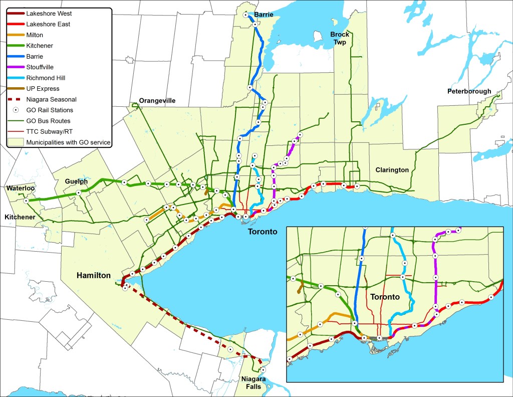
    John Tory’s original SmartTrack plan, shown with the existing TTC Subway and GO Rail networks. 

    In Friday’s Globe and Mail, we were treated to a scoop by Oliver Moore, that newspaper’s excellent transportation reporter, on behind-the-scenes revisions to Mayor John Tory’s SmartTrack rail transit platform, a topic that I discussed several times in this blog.

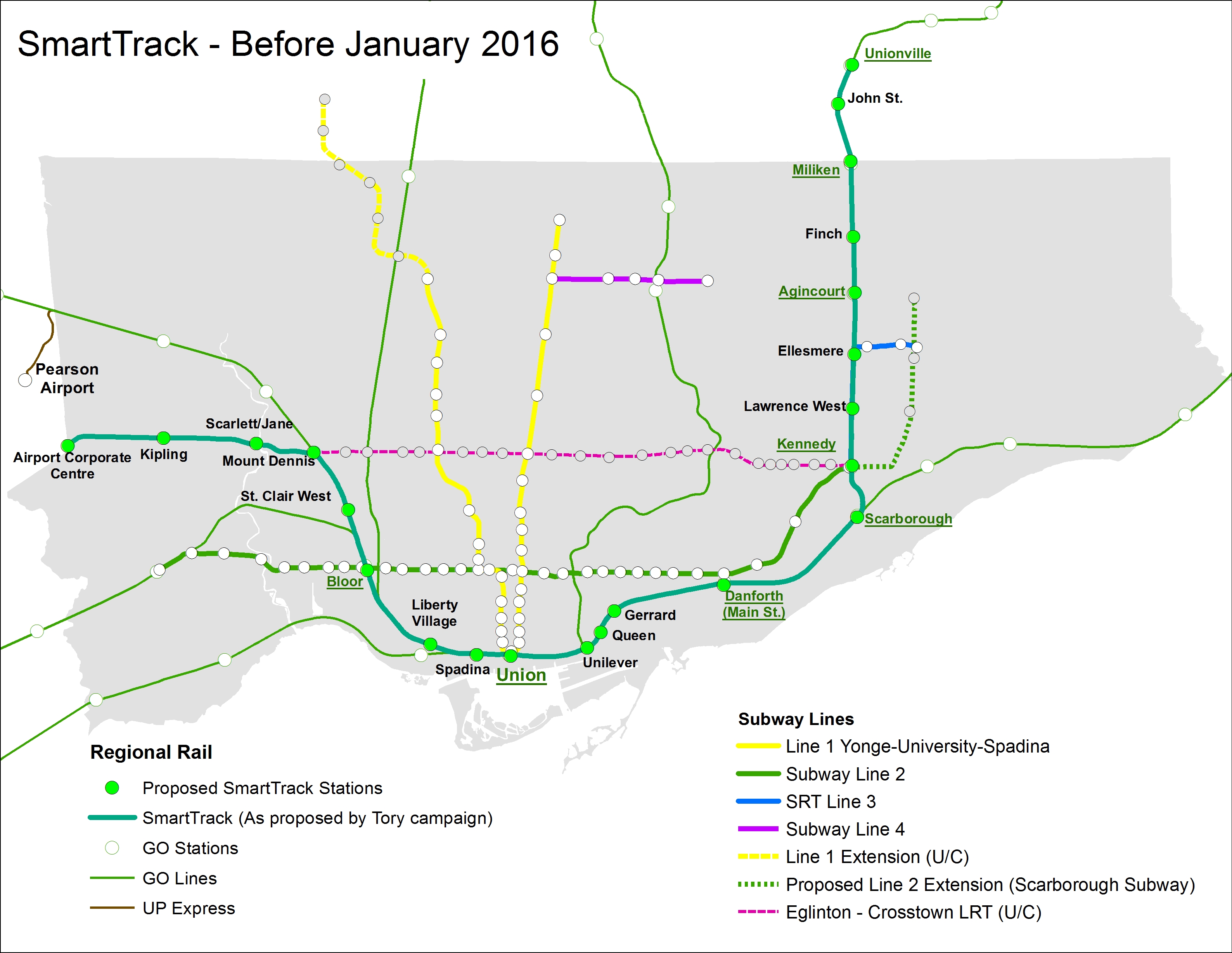
    Tory’s SmartTrack plan, dreamed up by a private-sector planning firm, was intended to connect office parks in Mississauga and Markham to Downtown Toronto, as well as serve the proposed First Gulf development at the Unilever site near the mouth of the Don River. Tory promised that it would provide relief to Toronto’s overburdened subway system, but that was never the main objective.

    I have been aware of rumours that Tory’s SmartTrack plan was going to be walked back due to mounting costs and technical issues of implementing the mayor’s campaign promise. The team that came up with the idea of a U-shaped rail network intended to connect several suburban employment centres with Downtown Toronto overlooked some important details, such as the availability of land along the former Richview Expressway corridor along Eglinton Avenue West. SRRA, the private-sector planning organization that came up with SmartTrack, assumed that the Richview lands were available and owned by the province, but the city owned the land, and sold much of it off for development in 2011 and 2012.

    The cost of building the western spur between Mount Dennis and the Airport Corporate Centre was, in all likelihood, found to be prohibitive, though we have yet to find out what the estimated costs for a tunnel along that section. The eastern section, north of Kennedy Station, would have closely paralleled both the Scarborough RT and the proposed extension of the Bloor-Danforth Subway to McCowan Road, a project that Tory also backed.

    The Globe and Mail’s Oliver Moore reports that SmartTrack will cover a much shorter section than the map on John Tory’s 2014 campaign brochures. Frequent rail service will complement existing GO Transit Regional Express Rail (RER) services on the Kitchener and Stouffville Corridors, terminating at Mount Dennis and Kennedy Stations. The Eglinton West section will be covered by the “shovel-ready” Phase II of the Eglinton-Crosstown light rail transit line (ECLRT), which is already under construction east of Mount Dennis. (The provincial government deferred funding for this section of the ECLRT in 2010 for budgetary reasons.) The north-eastern section of SmartTrack, between Kennedy Station and Unionville Station in Markham, will be deferred.

    This new plan, which is being finalized and will likely be officially announced later this year, will cost an additional $2-billion to $3.5-billion to the existing plans for RER, in order to facilitate more frequent, subway-like frequencies, as well as complete the western section of the ECLRT.

    If Moore’s reporting is accurate (and I have seen maps and other materials that collaborate his report), then Tory will have to eat some crow. Spin doctors will have to figure out how to polish this turd as Tory seeks a second mandate in 2018. It’s also inevitable that the new additional service on this corridor will continue to be branded as “SmartTrack.” But this is the best solution, and maybe this is a sign that Tory is learning on the job.

    At the end of the day, what Toronto gets is what Metrolinx’s “Big Move” plan envisioned: upgrades of most GO Transit corridors to RER, as well as Phase II of the Eglinton-Crosstown LRT line to Pearson Airport. (The Finch West and Sheppard East LRTs are also approved, but have yet to start construction.) The paired-down SmartTrack plan, if trains are frequent enough, and with attractive transfers with the subway and TTC surface routes, will draw some riders. It could help provide medium-term relief as the [Downtown] Relief Line Subway is studied and built.

    New SmartTrack Plan
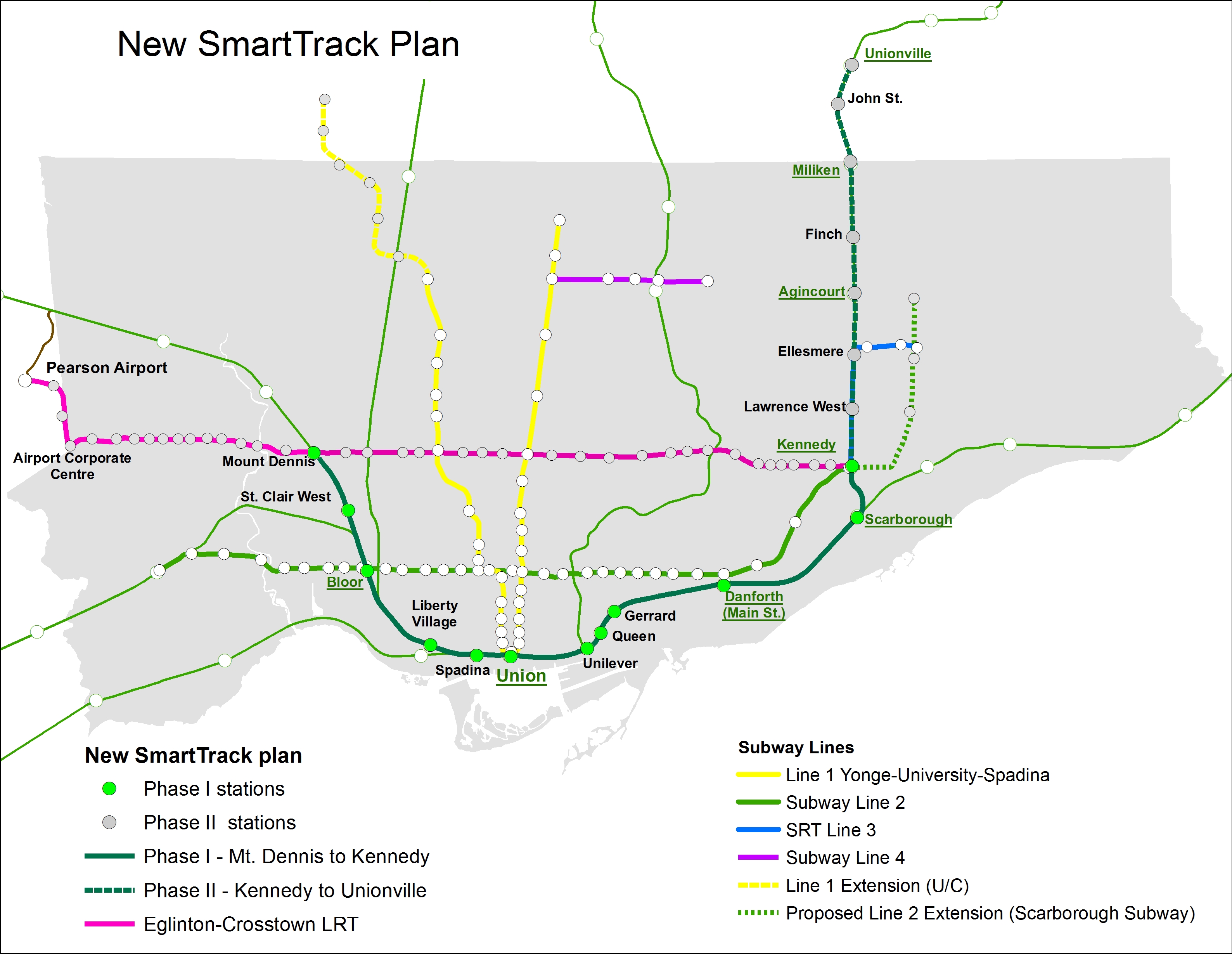
The new SmartTrack plan, including Phase II of the Eglinton-Crosstown LRT

    But where I find myself annoyed is when I realize that we wasted over a year on Tory’s campaign slogan without any progress on the Relief Line (which will offer real, long-term relief to the Yonge Subway), the Waterfront West LRT, or other transit priorities such as accessibility at all existing subway stations. I remember during the 2014 election campaign, critics of Tory’s simplistic and flawed SmartTrack plan were dismissed without acknowledging their objections. It’s also worth noting that Tory also adopted rival Olivia Chow’s bus plan, after belittling it during the campaign.

    In order to provide fast and reliable transit to the Airport Corporate Centre and Pearson Airport itself, there are opportunities to refine the western section of the Eglinton-Crosstown LRT. The environmental assessment called for 15 stops between Mount Dennis and Pearson Airport, while SmartTrack would have had as few as three stops along the same section. If the ECLRT can be sped up at all, it would be worth considering. I would also be interested in whether the SmartTrack corridor could be integrated with the UP Express rail link, whose ridership started off quite low.

    And maybe, just maybe, the high costs of constructing the Scarborough Subway extension will also prompt a rethink, going back to the original LRT replacement and extension plan. As the Spadina Subway extension to York University and Vaughan is now two years late (and yet another $400 million over-budget), maybe there’s an opportunity to get it right there as well. It’s also imperative that proponents of the Relief Line Subway strike now.

    I could be giddy with the revelation that Mayor Tory’s signature campaign platform is coming undone, having foreseen the problems with his plan. But I’m not. However, I do take pleasure in knowing that we have a smarter plan in the works.


  • Metrolinx’s strange priorities

    crosstownroutemaplarge-640x367Map of the Eglinton Crosstown LRT showing the original working station names along the corridor

    It’s too often that we hear from business leaders, planning experts, and pundits that politicians should be kept out of transit planning. To some degree, this makes sense. We saw what happened when politicians, pandering for votes from Scarborough, derailed a viable, ready-to-go transit plan in favour of a shiny, unfunded, subway line.

    Metrolinx’s appointed board is made up of developers, business people, advisers, administrators, and two retired politicians. It seems like the kind of place where smart, level-headed, apolitical decisions could be made. That is, until board members start bickering about station names.

    In December, Metrolinx rubber-stamped, with little debate, a problematic GO Transit fare increase. But it then spent four times as long debating the names of three stops on the Eglinton-Crosstown LRT corridor. And today, there will be a special teleconference meeting to decide – hopefully once and for all, these three names. Maybe then they can get on to serious business.

    I discuss this further in Torontoist this morning.

  • Milton’s self-inflicted growing pains

    There’s an interesting article in today’s Toronto Star about Milton’s growing pains. The Town of Milton, which has grown tremendously in the last 15 years, complains that the province has neglected to provide the growing municipality with transit and other infrastructure. In 2001, its population was only 31,471. But In 2006, after finally connected to “The Big Pipe” that brought treated lake water to the municipality, the population increased to 53,939, an increase of 71.4%. In 2011, the town’s population went up again to 84,362; by 2016, Milton’s population will be well over 100,000.

    But no one should be surprised by Milton’s growing pains. Milton’s population stagnated for years as its reliance on well water constrained residential and commercial growth. Once all that developer-owned land had access to water and waste water pipes, of course, tract housing, big box stores, and warehouses were going to follow. In recent years, Milton’s housing density has increased in accordance with the province’s Places to Grow Act; with more townhouses and low-rise apartment buildings and houses on smaller lots. But apart from higher densities, land use and planning is still based on automobile ownership and suburban zoning plans.

    Milton is outside the continuous built-up Greater Toronto area. It doesn’t have great transit links, apart from the rush hour GO Trains. Apart from two interchanges off Highway 401, it doesn’t have great highway access. If it’s cheap housing you seek, and nothing else, Milton might be the right place to live. But if you want transit, parks, walkable neighborhoods, access to community services, and short drives, Milton isn’t the right place to buy.

    Many of the concerns are valid. The local hospital hasn’t expanded to accommodate the growing population. Highway 401 hasn’t been expanded through Milton since the 1980s. And while GO Transit has increased the number of trains (from five to nine outbound and inbound trips in the last two decades) and buses, the parking lot has completely filled up.

    But one of the main messages that I read in the article is that there isn’t enough parking. To paraphrase Homer Simpson, parking is the cause of  – and solution to – all of Milton’s problems. Residents and councillors complain about parking at the GO station, such as resident Giles vanderHolt, who says, “there’s a huge need for more GO transit parking and better train service to Milton.”

    GO Transit isn’t going to be adding more train service to Milton any time soon. The Milton Line also serves six stations in Mississauga, and is the busiest route outside the frequent Lakeshore corridor. But the Milton line is almost entirely owned by Canadian Pacific, and it’s a busy freight line. GO simply cannot add any more trains, and if it did, it wouldn’t solve Milton’s parking problem.

    Surrounding the GO Station, there’s a retail plaza anchored by a Loblaws, and surrounding it, there are several industrial parks and single family houses. There is no transit-oriented development located there, nor is any planned.

    Milton GO Station and surrounding areas

    I have plenty to say about GO Transit’s reliance on free parking, and I wouldn’t be surprised if GO is drawing up plans for a parking garage at Milton. But to be fair, people don’t move to Milton that are planning to give up their cars. Milton Transit isn’t very good, but it does use the GO Station as its primary hub. Meanwhile, GO has been trying a new ride-booking system for commuters to use to get to and from Milton GO Station. That’s an interesting idea that could be expanded to other outer-suburban communities as a short-to-medium term solution. If GO ever implemented parking charges, it could prove to be a good alternative for commuters where transit links are spotty or non-existent. But Milton could do far more to encourage people to walk, bike and take transit to its station, and develop an urban core.

    Milton has been lobbying for years for a university campus, at a site called “Milton Education Village.” But it wants to locate the campus in a greenfield site a 15-minute drive away from the GO Station, distant even from Highway 401. Students from outside Milton will either be dependent on cars to reach the site, or had better hope that transit connections from the west aren’t as bad as they are from the Milton Carpool Lot.

    Oshawa made the mistake of building a major campus as far as possible from its downtown core and transit infrastructure. Why does Milton want to do the same thing?

    On one hand, Milton is right to complain about poor infrastructure. People live there, by choice or by necessity, and they deserve a proper hospital and other provincial services. GO Transit is doing the right thing by trying out a ride-sharing service to and from the GO station. On the other hand, Milton is a “leap-frog” suburb, with poor urban planning and an auto-centric mentality that has helped to create a lot of its mess. Building some transit-oriented development around the GO station, and improving transit links would be a good place to start turning the page.

    0FXZYgd.jpgScreenshot from the classic Simpsons episode “Homer vs. the Eighteenth Amendment”

  • King Street: a mess of Uber proportions

    21207239313_0c5746b3f8_o

    One of the most frustrating things about living and working in central Toronto is having to rely on streetcars for east-west travel. This isn’t the fault of the streetcars; when free of traffic, they’re a smooth, fast and comfortable way to get around. But trapped in the quagmire that is downtown traffic, streetcars are painfully slow. They’re stuck behind left-turning cars and trucks. Cars plugging the curb lane, legally or not, force all traffic into the streetcars’ path. Replacing streetcars with buses isn’t a solution either; not only would more buses (and drivers) be required to match the each streetcar’s superior capacity, but buses would be forced to weave in and out of the curb lane around taxis, parked cars, delivery vans and other obstructions.

    Rapid residential growth, both east and west of the downtown core, have overloaded the 504 King Streetcar. With 64,600 daily riders, it’s the busiest surface route in the system. The city has done little to facilitate this highrise boom in neighbbourhoods such as Corktown and the Distillery District in the east, and CityPlace, Liberty Village, Niagara, and Queen/Gladstone in the west. Further west, the highrise condos built at Humber Bay Shores must either rely on a painfully slow and unreliable ride on the 501 Queen Streetcar, take an infrequent double-fare express bus, or ride a bus up to the Bloor Subway.

    No wonder then, Uber, the controversial firm that has delighted passengers with cheap transportation, but put the livelihoods of taxi drivers in jeopardy, launched UberHop, a variation of its “ride sharing” service that offers flat $5 rides between neighbourhoods along the King Streetcar and the downtown core. From a purely capitalist viewpoint, Uber is filling a need that’s been left unfulfilled.

    (more…)

  • Dispatches from Durham Region, and Kingston Road tokenism

    Two weeks ago, I was out exploring Durham Region, the eastern end of the Greater Toronto Area. While south Durham Region is mostly made up of generic suburban sprawl, there are some interesting historic villages and new urbanist neighbourhoods. North of Highway 7, Durham Region is still mostly rural, though plans for a new airport in North Pickering may change that.

    Sadly, Durham Region remains auto-centric in its outlook, even more so than other suburbs to the north and west of Toronto. The provincial government is constructing an eastern extension of Highway 407, with two new connecting highways to Highway 401 either nearly complete, or proposed. Oshawa, the largest city in Durham, is the birthplace of General Motors Canada, but while the auto industry declines, the city has been continuing to make many civic planning mistakes. And in Ajax, a small symbol of change – new bus and bicycle lanes – is still merely a token effort.

    (more…)

  • It’s time for two-hour transfers on the TTC

    15102078722_2ee5e4e9e3_k

    As of Monday, December 14, all TTC streetcars will operate under a “proof-of-payment” system; allowing customers to enter through the rear doors, as they currently do on 509 Harbourfront and 510 Spadina, the two routes partially equipped with the new Bombardier low-floor streetcars. All-door loading and proof-of-payment (POP) is supposed to be in effect on streetcars on Queen Street, but in practice, operators inconsistently open the rear doors; sometimes at all stops, often just a few downtown stops, sometimes only at Yonge Street, sometimes not all.

    This new policy requires passengers to have a valid pass, transfer, or Presto card on board every streetcar; fares can continue to be paid at the front door on the older CLRVs and ALRVs; at that point a transfer must be obtained.

    TTC fare inspectors have been handing out brochures about the new policy to streetcar passengers, informing them about the upcoming change:

    The design of the new low-floor streetcars has required POP: they have four doors instead of two doors on CLRVs and three on ALRVs; the operator is in a separated cab, and normally does not interact with passengers, including fare collection and handing out transfers. At this point, at the end of 2015, all streetcars on the 509 and 510, as well as the 505 Dundas and 511 Bathurst routes were supposed to be equipped with low-floor accessible streetcars, but the many delays at Bombardier has resulted in only the twelfth new streetcar, #4413, entering service today.

    By the end of the year, all TTC streetcars (not just the new Bombardier LFLRVs) will be accepting payment by Presto Card, one small step towards the elimination of tickets, tokens and paper transfers, a process already complete at many suburban GTA transit agencies.

    But widespread adoption of Presto at the TTC will result in a few challenges unique to it, thanks to its outdated transfer policy that dates back over 100 years.

    On the TTC, transfers are only valid for continuous one-way trips, no stopovers permitted. But most other major systems in Ontario work on the time-based transfer system, that allows for stopovers, even return trips within a 90 minute period (the policy at Grand River Transit) or 120 minute period (permitted in Mississauga, Brampton, York Region, Hamilton and elsewhere). After boarding the first bus, each additional tap with a Presto card will not result in a new fare deducted until the 90 minute or two hour time limit has passed.

    The TTC will have a different policy. Paper transfers will still be required for Presto card holders if they intend to transfer to a bus (Presto readers will not be coming to the TTC’s buses for another year); but transfers to connecting streetcars and subway stations can be done by tapping the card on the new vehicle or at the subway turnstile. If it’s a valid transfer under the TTC’s rules, it will not deduct another fare. Here’s the TTC’s Brad Ross (the TTC’s amazing Head of Communications) clarifying this:

    https://twitter.com/bradTTC/status/672810002688569344

    But there’s a hiccup:

    https://twitter.com/bradTTC/status/672841401177014272
    https://twitter.com/bradTTC/status/672841244918210560

    If a passenger taps onto another vehicle on the same route, which is quite a common occurrence due to delays, short-turns, and diversions/shuttles, the Presto Card will deduct a second fare.

    There is an easy solution: two-hour transfers. It would eliminate confusion, allow for short stopovers and quick two-way trips, and solve such issues such as customers re-boarding streetcars and buses on the same route. Allowing Presto cardholders the same luxury as that enjoyed in Toronto’s suburbs would provide an incentive to passengers paying by cash and token to switch. After all, the TTC already offers a two-hour transfer on St. Clair Avenue, a pilot project left over from the construction of the streetcar right-of-way.

    The TTC already considered at time-based transfers in 2014 as it planned for the transition to Presto for fare collection. The Commission estimated that it would cost $20 million in annual revenue (thanks to lost fares stopovers and single-fare return trips), but it would by a lot of goodwill. And I doubt that the TTC would lose $20 million a year as it might attract new riders, especially during off-peak periods.

    It’s now time for the TTC to bite the bullet to make it easier to ride the rocket.

  • GO Transit plans to raise fares in 2016. How about a better fare system?

    Note: Updated in February 2016 due to a conflicting chart.

    At Thursday’s Metrolinx Board Meeting, the Board of Directors will be voting on a GO Transit fare increase effective February 1, 2016. As has become common, Greg Percy, the President of GO Transit, will be recommending a tiered fare increase, and we should expect that the Metrolinx Board will rubber stamp this proposed fare hike, as it usually does.

    Recently, I wrote about the many problems with GO Transit’s fare structure. It penalizes short trips, it does not allow for any fare integration with the Toronto Transit Commission, and many trip pairs (particularly the Barrie, Richmond Hill, and Stouffville Corridors) are priced lower than they should be compared to other stations. In another post, I suggested that GO Transit should seriously consider charging for parking at its lots, as constructing and maintaining parking lots is a major expense that all GO Transit users are paying for, whether they use them or not.

    I was somewhat surprised to see that the fare increase will not apply to short trips, those currently costing between $5.30 (the lowest fare possible) and $5.69. This would freeze the one-way ticket price for trips such as between Danforth, Union, and Exhibition Stations. With a slight increase in the “loyalty discount” offered tot Presto Card users when they pay a GO fare,  from 10% to 11.15%, this results in a very slight fare decrease for short trips.

    You can read the GO Transit report recommending a fare increase here.

    (more…)

  • The trouble with Trans-Cabs

    In my last post, in which I discussed the gaps in the Golden Horseshoe’s transit network (and offered unsolicited advice to Metrolinx), I used the example of Milton, in which a carpool lot served by several GO Transit bus routes was largely disconnected from the rest of the local transit system, and located several kilometres from the main GO hub at Milton Station.

    When I pointed out that Milton Carpool lot, at the junction of Highways 401 and 25, was only served by Milton Transit’s route 1A/1B, which runs only during rush hours, Twitter user YIGE corrected me:

    https://twitter.com/yige_t/status/669902364111822848

    YIGE is correct. Milton Transit does offer a Trans-cab service in the residential areas north of Main Street in Milton, as well as some of the institutional and industrial zones north of Steeles Avenue. I did not see it in the “System Map and Routes” section of the website; it has its own page elsewhere.

    Trans-Cabs, are contracted taxi services that are intended to serve suburban or rural areas that would be inefficiently served by fixed bus services, but require a connection to the transit network. Several cities and towns in Ontario offer these services.

    In Milton, Trans-Cab operates between 8:30 AM to 2:30 PM, and between 5 PM and 6 PM on weekdays, and from 7:10 AM to 7:40 PM on Saturdays,  times when route 1A/1B does not operate. The service requires a 50-cent premium on top of the Milton Transit fare, and the transfer point isn’t at the GO Station, where all eight fixed route buses connect, but at a point in Downtown Milton where only Route 2 connects. Anyone headed elsewhere must then transfer to Route 2 to the GO Station, and transfer yet again. It’s not at all convenient, and the service ends far too early in the evening, especially for commuters and students headed home from Kitchener-Waterloo or Guelph. And unlike connecting between GO and Milton Transits at the station, there’s no co-fare available to any other GO bus service.

    Passengers must also request a ride at least an hour in advance if heading to the transfer point; passengers heading to the Trans-cab service area only have to let the Route 2 operator know they need the service.

    Milton_TransCab
    Map of the Milton Transit Trans-Cab service area, original found here.

    In the Greater Toronto and Hamilton Area, Hamilton Street Railway also provides a Trans-Cab service, serving exurban areas in Stoney Creek (Winona) and Glanbrook. Like Milton, the Trans-Cab service requires a 50 cent premium above the regular fare, and requires a transfer to a regular bus route. In Glanbrook, the service is offered Monday through Saturday from 6 AM to 7 PM, and in rural Stoney Creek from 5AM to 1AM. The HSR system map shows the Trans-Cab service areas. Like Milton, pick-ups have to be arranged at least an hour in advance.

    Peterborough and Greater Sudbury also operate Trans-Cabs; again, in those cities, they serve outlying areas that are difficult to serve with fixed bus routes.

    The Hamilton example illustrates where Trans-Cabs make more sense: in outlying areas where demand is low, the population density sparse, but there’s a need for transit access. In Milton’s case, operating a fixed route serving the urbanized area north of Main Street makes more sense, especially as it links to a major GO Transit connection;. In Milton, a Trans-Cab might be more useful, say, for serving areas outside the Milton urban area, such as Campbellville and Mohawk Racetrack.

    Really, either the Town of Milton/Milton Transit, or GO Transit should work to get the gap between the Highway 401/25 carpool lot and the town transit system fixed properly. An inconvenient Trans-Cab service simply doesn’t cut it.

  • The Golden Horseshoe’s missing links

    14182301824_167b4e754a_k
    GO Transit bus at Uxbridge

    Over the last 15 years, GO Transit has done well expanding its bus and rail operations. It opened up new stations, such as Mount Pleasant, Lincolnville, Barrie South, Allandale Waterfront, and West Harbour. It introduced the Highway 407 service, finally making York University accessible to thousands of suburban students. And it extended its reach to Waterloo and Peterborough, not only serving post-secondary institutions and residents in those cities, but also making it easier for cyclists like myself to explore new trails and destinations.

    But as GO Transit expands, there are many gaps, large and small, that should be closed. Coinciding with GO Transit’s expansion, intercity bus operators have been cutting back; dozens of Ontario towns and cities no longer have any coach service, and many more have saw their service cut back. Several municipalities in GO’s service area have resisted operating local transit systems, and GO’s use of park-and-ride lots has made their bus services difficult to reach without a car. In this post, I discuss some of these challenges.


    Related:

    (more…)

  • Not so fair-by-distance: GO Transit’s problematic fare system

    Not so fair-by-distance: GO Transit’s problematic fare system

    GO Network 2015GO’s bus and rail system serves 39 municipalities and reaches points over 130 kilometres from Union Station

    In 1967, GO Transit started out as a simple commuter service from Oakville to Pickering (with two additional trains to and from Hamilton). In 1970, it started its first bus service, connecting Oshawa and Hamilton to the hourly train service at Pickering and Oakville. Eventually, GO expanded to other corridors, inaugurating the Georgetown service in 1974, and taking over former suburban Grey Coach and TTC routes in the 1970s. By 1981, GO was operating trains on all seven of its current corridors, expanding and extending its bus rail services ever since. As a commuter rail and bus system, GO Transit is a great success story, there were over 68 million boardings in 2014, and service continues to expand. Regular bus service goes all the way to Niagara Falls, Peterborough, and Waterloo, serving post-secondary institutions and long-distance commuters. But there are many ways in which it can improve; its fare structure is just one of them.

    Previously, I explained why GO Transit should consider charging for parking at its commuter lots. GO Transit provides over 60,000 free parking spaces, but the cost of servicing those lots is borne by all passengers, whether or not they drive to the train or not. This isn’t terribly fair to those customers who arrive by foot, by bicycle, or are able to get a ride. In the suburbs outside the City of Toronto, most transit agencies offer a co-fare – a discounted fare for taking local buses to connect to and from GO Transit, but no such fare integration exists with the TTC. But the parking subsidy enjoyed by drivers is only part of the unfair pricing scheme levied by GO Transit.

    GO Transit describes its fare scheme as “fare by distance.” And to a degree, this is accurate. Generally, the farther one travels, the more expensive the fare. So far, so good. But fares for short trips cost far more than longer ones per kilometre traveled, and fare increases for short trips have risen at a greater percentage rate than fare hikes for long trips.

    Steve Munro wrote about the myth of GO’s fare-by-distance scheme last year. As Munro put it, “the fare structure is rigged against short distance trips, and this has been getting progressively worse for a decade.”

    If GO Transit wishes to fully become a regional transit service, it needs to address both its unfair fare scheme and its lack of fare integration with the TTC.

    go_rail_and_bus_network,_2015_by_seanmarshall1_11_18_2015_02_29_09

    I created a map of the full GO transit bus and rail system in CartoDB to illustrate GO Transit’s reach; all stations and major bus stops include some fare information (the distance and cash fare to Union Station) and the number of parking spots. 

    (more…)