Category: Transit

  • A need for high-speed rail reality (Updated)

    IMG_6258-001VIA Rail train at Brampton Station, on the Toronto-Kitchener rail corridor

    Updated Friday May 19, 2017:

    Today, Premier Kathleen Wynne announced the commencement of an Environmental Assessment on bringing high-speed rail to Southwestern Ontario, connecting Toronto and Pearson Airport with Guelph, Kitchener, and London, with Phase II continuing to Windsor, with a potential stop in Chatham.

    Former federal Transport Minister David Collenette was assigned to write a report on building the corridor; it is now public on the Ministry of Transportation’s website. It proposes operating speeds up to 250 km/h, making it a true high speed line (though slower than many lines in Europe and East Asia, which have cruising speeds between 270 and 320 km/h). The estimated cost of the project is estimated to be $21-billion, reducing travel times from Toronto to Windsor to a mere two hours.

    figure-es-2-proposed-future-southwestern-ontario-passenger-rail-network.jpg
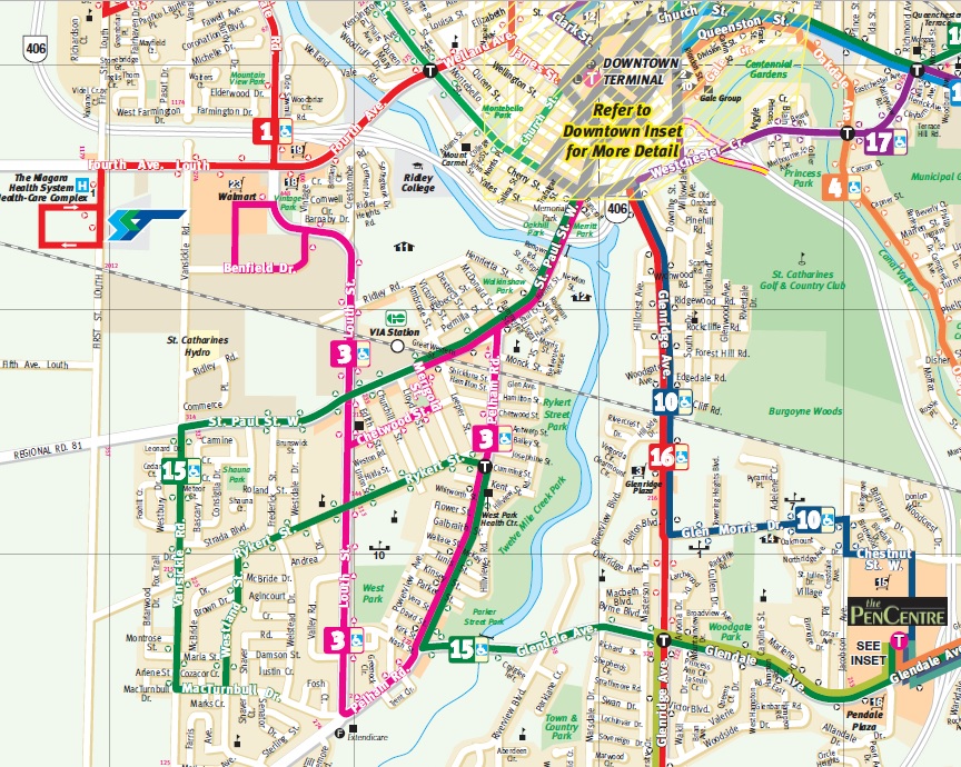
Proposed High Speed Rail system for Southwestern Ontario

    An option for a 300 km/h HSR service was studied, but found to be even more expensive, requiring more dedicated tracks. The 250 km/h option will allow it to use most of the existing Toronto-London and London-Windsor corridors.

    For southwestern Ontario, high speed rail could be a boon. Kitchener-Waterloo is a major educational and technological hub; faster and more frequent rail service will benefit university students, tech workers, and other commuters, perhaps those priced out of the Toronto housing market. London’s economy has taken some hits in recent years, so bringing it within commuting distance to Toronto and K-W gives residents there more options.

    Between Toronto and Kitchener, the report assumes two off-peak HSR trains an hour, and one GO train every hour, making local stops. It also assumes that GO RER service will continue to terminate at Bramalea, a poor location to terminate regional rail services; Downtown Brampton is one stop away. Building the “missing link” along Highway 407 will allow many more trains to pass through Downtown Brampton, which would allow for local RER trains to be extended to west Brampton, at Mount Pleasant GO. It would be a shame if the HSR plans (which, in principle, I support) pushed aside regional and local needs.

    Statford and St. Marys, which are only served by VIA trains (and no intercity coach service) will also have to be considered, as they will be bypassed by HSR. As well, towns and cities elsewhere in southwest Ontario, such as Simcoe, Tillsonburg, Wallaceburg, and St. Thomas, have no bus or rail access. For less than the $15 million pledged for the HSR EA, the province could fund several years’ worth of basic intercity bus service to connect these communities together.

    Unless assumptions change, Brampton residents will see twice as many trains speed by their downtown core than stop, which I think is unfortunate. In the original post below, I was worried that high speed rail dreams would distract from more immediate needs. I’m now afraid that I was right.


    Original post dated April 26, 2017

    When have I heard this one before?

    According to CTV News, the provincial government is looking to build a new high-speed rail line between Toronto, Kitchener, and London. The new plan, to be announced next month, is based on the work of former federal Transport Minister David Collenette.

    During his time as Transport Minister under Prime Minister Jean Chretien, Collenette backed incremental VIA Rail improvements, as well as VIA-FAST, a higher-speed train service between Toronto, Ottawa, and Montreal. Those proposed improvements were cancelled when Paul Martin became prime minister; currently VIA is pushing for a revised version of that previous plan. Collenette also pushed hard for a rail link between Toronto Pearson International Airport and Union Station, a fundamentally flawed proposal known as “Blue 22.” That airport rail link proposal was later relaunched as a provincial project and opened as UP Express in 2015.

    Ontario Transportation Minister Steven Del Duca was not especially clear about the plans for such as high-speed rail service, saying “…there are multiple definitions for high-speed rail depending on what you’re looking at.” Del Duca cited “geographical limitations,” while hoping that the federal government would contribute funds towards the project.

    Interestingly, only a week ago, Deputy Minister Deb Matthews (and London MPP) was downplaying the province’s plans, saying the province only promised to study, but not necessarily build, the high-speed rail corridor.

    I worry that high-speed rail is a distraction. In Canada, we have an abysmal record of proposing high-speed rail projects, but never following through. Even VIA’s less ambitious plan for dedicated tracks and new equipment to provide more frequent and reliable service, with somewhat faster travel times, is not yet secure.

    There is already a Toronto-Kitchener-London service; two VIA trains operate daily in each direction along the entire route, while GO Transit operates more frequent weekday trains to Brampton and four weekday round trips to Kitchener. Before the 1990 Brian Mulroney-era VIA cuts, there were five round trips on this line. In the 1980s, the fastest VIA train between Toronto, Kitchener, and London took 3 hours, 2 minutes; today, the fastest train is 3 hours, 22 minutes.

    This Rick Mercer Report video will never get old

    All that I want for the Toronto-Kitchener-London corridor in the short-to-medium term is the same as what VIA is proposing between Toronto and Montreal:

    • Dedicated tracks. On the Toronto-Kitchener-London corridor, this means building a new rail corridor, known as “The Missing Link” for freight trains between Halwest (near Bramalea GO Station) and Milton. This new route would divert Canadian National (CN) freight trains that currently pass through Brampton and Georgetown on the Toronto-Chicago mainline. Potentially, Canadian Pacific (CP) trains passing through Toronto and Mississauga could also be diverted, freeing up capacity on GO Transit’s Milton Line. CN freight traffic limits the frequency and speed of GO Transit rail service to Brampton and Kitchener; moving the through freight trains would allow for frequent, electrified, GO RER service beyond Bramalea, as currently proposed. CN is interested in partnering with the province to build this link; CP has not expressed interest.Ibi Missing Link map.jpg
      Map of the “Missing Link” from a 2015 IBI Group report
    • Rail improvements. Between Georgetown and Kitchener, the railway is owned by Metrolinx, and hosts four weekday GO Transit trains in each direction, two daily VIA trains in each direction, and several Goderich-Exeter Railway (GEXR) freight trains. Track is in good shape, but has several slow sections, including a two-kilometre section west of Guelph Central Station where trains crawl at 10 miles an hour (16 km/h).

      Improving rail speeds in central Guelph will be expensive, especially where the railway runs in the middle of residential Kent Street, but it will be worth it.
      Beyond Kitchener, the track is leased and maintained by GEXR, which has allowed the rails to deteriorate. Slow speeds are acceptable by a no-frills short line freight operator, determined to minimize maintenance costs, but not so for passenger rail. VIA trains are consistently late because of the condition of track, especially between Stratford and London. Purchasing the track, installing welded rail, and improving grade crossings will substantially improve reliability and speeds on this corridor.Incremental improvements, such as grade separations, improved signalling, and new passing tracks, would permit frequent, reliable, and faster rail service.
    • A new train fleet. Via Rail’s coaches are nearing the end of their useful lives; among the rolling stock used on the Toronto-Kitchener-London service are HEP-I and HEP-II coaches built in the 1950s and refurbished several times since. GO Transit’s commuter coaches are acceptable for shorter trips, but are uncomfortable for long-distance travel. With the completion of the “Missing Link” and the acquisition of the Kitchener-London rails, it would be possible to electrify the entire corridor. Electric trains benefit from faster acceleration times, especially electric multiple units.

    Some of these improvements can be started within the next year, before the 2018 provincial election. If the province wants to show that it’s serious about providing effective rail service to Kitchener and London, there’s no need for another high-speed rail study. Simply continue the work on the “Missing Link,” plan for GO RER to continue west of Bramalea GO, improve the existing rail infrastructure, and acquire the optimal fleet for medium-distance rail services. Once that is complete, planning for even higher speeds, possibly with a new purpose-built alignment, should begin.

    Canadians have been teased with high-speed rail proposals that never get anywhere, meanwhile existing rail infrastructure is neglected and intercity services are cut. It’s time to get moving with a sensible plan that can start right now.

  • GO Transit’s 404 Error?

    IMG_8969-001GO Train at Gormley Station

    Previously on this blog, I wrote about how new public institutions like hospitals and university campuses are built in isolated, auto-dependent areas without regard to provincial land use policies. In St. Catharines, a new modern hospital on the city’s western outskirts replaced two urban sites, despite available opportunities that would be more accessible to at-need populations. In Orillia, Lakehead University built its campus on the edge of that small city, far from other institutions or its charming downtown core. Similar decisions are being made for new hospitals and university campuses in Niagara Falls, Windsor, and Milton.

    But Metrolinx and GO Transit, its regional transit subsidiary, often fail too to meet the provincial goals of intensification of urban centres and major transit nodes, containing urban sprawl, and promoting sustainable transportation. In Downtown Brampton, an anchor mobility hub, Metrolinx plans to build a new surface parking lot — demolishing several houses and two office buildings in the process — to satisfy commuters’ demands for free parking.

    This failure is especially evident on the newly extended Richmond Hill Line, where one new station — Gormley — opened late last year, and another — Bloomington — is now under construction. Both stations do not support any evident land use policy (both are located on the environmentally sensitive Oak Ridges Moraine); they continue GO Transit’s heritage of building stations that serve car owners, but remain largely inaccessible to pedestrians, cyclists, or local transit users.

    I recently took the train north to Gormley to inform my critique of GO Transit’s new stations. I came away even more disappointed than I had expected.

    (more…)

  • A new low for the Scarborough Subway champion

    Note: a version of this article has been cross-posted to Spacing Toronto

    For 2016’s annual Torontoist Heroes and Villains feature, I nominated Toronto Councillor Glenn De Baeremaeker (Ward 38, Scarborough Centre) as villain of the year. (“Pedestrian blaming” won that dubious honour.) But I remain proud of my choice. As I wrote back in December:

    De Baeremaeker’s record of environmentalism has been overshadowed by an increasingly antagonistic tone, pitting supposedly downtrodden Scarborough against the rest of the city in his one-track quest to build a one-stop subway extension to his ward. In his myopic support of the subway, De Baeremaeker is opportunistic and vindictive, takes the low road, insults critics who engage in good faith debates, and in the process does a disservice to the community he represents.

    Councillor De Baeremaeker hasn’t changed his tone.

    Yesterday, May 10, the City of Toronto held a public consultation at Scarborough Civic Centre on the next phase of planning for that one-stop, 6.2-kilometre subway extension, which is estimated to cost $3.35 billion, and open no earlier than 2026.

    I wish I was able to attend last night’s meeting, as disgruntled Scarborough residents questioned the merits of that transit plan. And Councillor De Baeremaeker shamelessly blamed “downtown councillors” for the shortcomings of that one-stop subway. For a councillor who is rightly proud of his past environmental advocacy, it was surely a low point.

    Toronto Star reporter Jennifer Pagliaro, an excellent local journalist, covered the meeting. 

    City Scarborough MapCity of Toronto map from February 2016 illustrating current plans for the Scarborough Subway and connecting transit.

    At the public consultation, TTC and City planning staff answered queries from members of the public, many questioning the utility of the single-stop subway. There are no additional funds to rough in future stations, such as at McCowan Road and Lawrence Avenue, where the line would intersect the busy 54 Lawrence East bus and serve Scarborough General Hospital. As building future stations later would require an extended shut-down of the line, the one-stop subway extension will likely be forever a one-stop subway.

    (The eastern extension of the Eglinton-Crosstown LRT from Kennedy Station to University of Toronto’s Scarborough Campus is also part of the new plan for Scarborough, but the LRT component is unfunded.)

    Shameless as ever, Councillor De Baeremaeker resorted to strawman arguments, talking up a “suburban/urban divide”:

    [De Baeremaeker] blamed “downtown councillors,” who represent the most densely populated wards in the city, for not wanting to fund more frequent transit stops like their residents enjoy.

    Yes, it is true that all councillors representing central Toronto opposed the subway extension, but so did several suburban politicians, most notably Councillor Paul Ainslie (Ward 43 – Scarborough East). Yet not one of those councillors wanted less transit for Scarborough. Instead, they backed a seven-stop LRT replacement for the ageing Scarborough rapid transit line, including an extension to Centennial College and Sheppard Avenue in Malvern. That less-expensive line was fully funded by the provincial government, which would have permitted scarce funds to be spent on other transit projects across Toronto.

    Meanwhile Mayor John Tory was most interested in pushing SmartTrack, a fantasy rail project that got pared down as parts of the line were found to be impossible to build, and costs increased. The eastern end of SmartTrack conflicted with the Scarborough Subway extension. The three-stop subway plan was cut to a single stop at Scarborough Centre, to keep costs down and to not cannibalize SmartTrack.

    Yet Tory and De Baeremaeker are allies on the subway extension; Tory named him one of his Deputy Mayors to champion the line. But Tory’s push for his own project put him at odds with De Baeremaeker’s focus on the subway extension, any subway extension, to his ward.

    It is also worth noting that until 2012, De Baeremaeker supported Transit City, the transit plan championed by David Miller that would have delivered three new light rail lines to Scarborough.

    I am not surprised by De Baeremaeker’s shameless politics. But his performance last night was especially crass and dishonest. Backed into a corner, faced with angry local residents, he lashed out at imaginary villains. But subway backers largely have themselves to blame; despite winning every recent vote on the subway plan, they have only one stop to show for it.

  • A better Hurontario Street – an LRT update

    IMG_0091-001.JPG
    Metrolinx light rail vehicle mock-up at Gage Park, meets a Brampton Transit Zum bus, 2013. 

    Earlier this week, I visited Brampton City Hall, where at a public open house, Metrolinx and city staff provided an update of the Hurontario Light Rail Transit project. Brampton City Hall was an ironic location for the open house; before Brampton Council voted against building the LRT up to Downtown Brampton and the GO/VIA Station, the LRT line would have stopped right here. Even with Brampton’s decision, there will be three stops in the city, so an open house for local residents to provide their feedback was still needed.

    hurontario_lrt_map_en-850x550
    The Hurontario LRT project, map via Metrolinx

    The open house was quite interesting as more design details were displayed. There`s a focus on promoting active transportation — walking and cycling — and urbanizing much of the corridor. Three lanes of motor traffic will go down to two in most places, and right turning traffic will be tamed. This will make Hurontario Street a safer and more pleasant place to be.

    Along the entire LRT corridor, Hurontario Street will feature separated bike infrastructure — for the most part, there will be separated bike lanes, with multi-use paths in a few areas, especially south of the Queensway, where Hurontario Street is narrower. Sidewalks are also wider. With only a few exceptions, cyclists will be able to ride across intersections without being required to dismount. Those exceptions are at the Queen Elizabeth Way, and at Highways 403 and 407, where Ministry of Transportation Ontario (MTO) standards at interchanges will force the “stop, dismount, wait for gap” regime; pedestrians will also still have to yield to motor traffic.

    img_8334-001
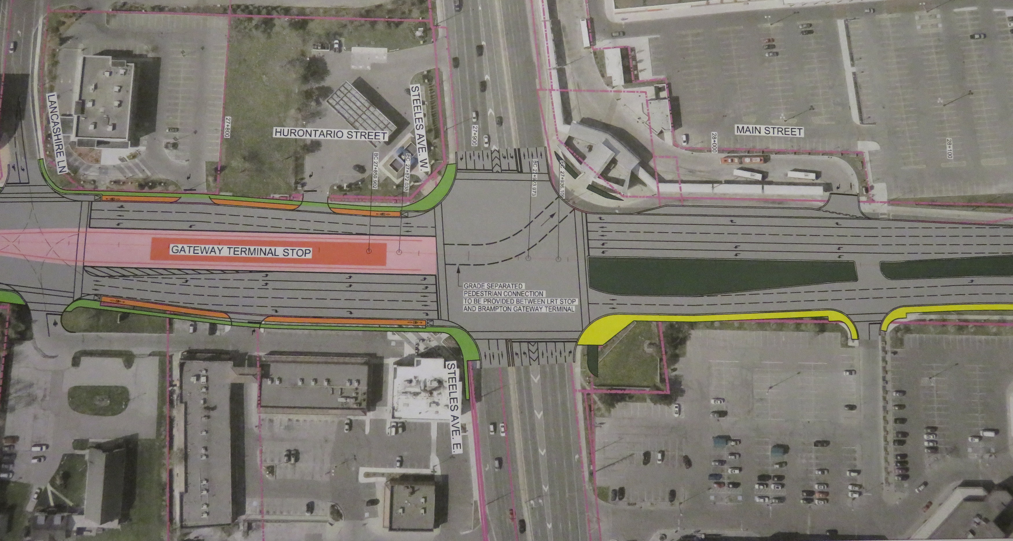
Typical cross-section once the LRT is built. The orange paths are the separated bike lanes, the green paths are sidewalks. Hurontario Street will only have two traffic lanes in each direction. 

    img_8328-001At expressways, like at Highway 407, pedestrians and cyclists still must yield to motor traffic at on-ramps. 

    In another benefit for pedestrians and cyclists, channelized right turns are eliminated along the entire route. Channelized right turns (like the one shown below) are convenient for motorists, but they increase conflicts with foot traffic and are incompatible with lower speeds and safe cycling infrastructure. Their removal also creates new room for streetscaping opportunities.

    4852433218_a9848b9973_o
    An example of a channelized right turn

    The northern terminus of the LRT, at least for now, will be at Steeles Avenue. As Brampton debates other LRT alignments (Kennedy Road and McLauglin Road are indirect alternatives to reach Downtown Brampton), the stop was moved to the south side of the intersection. This is unfortunate: the Brampton Gateway bus terminal, which opened in 2012, was designed to easily connect with the planned LRT stop on the north side of the intersection, with two short crosswalks across southbound Main Street.

    img_8331-001
    Planned LRT terminus at Steeles Avenue, including tunnel between the LRT platform and the Brampton Gateway Terminal. 

    Instead, a more expensive tunnel is required to accommodate transferring passengers between the LRT and buses. Elevators and escalators will provide direct access to the tunnel; crosswalks at Steeles Avenue and Lancashire Lane will also be accessible from the platform.

    The final contract is planned to be signed in mid-2018 and construction should begin in Fall 2018. As the City of Mississauga backs the LRT project, hopefully any change in the provincial government will not jeopardize this plan. Not only will Mississauga (and south Brampton) get a fine new transit service, it will also see a tamer, more urbanized main street.

    And maybe Brampton City Council will come to its senses and extend the transit corridor via the direct, least-expensive, Main Street alignment.

  • They call this a “SmartCentre”

    img_7608-001

    The word “smart,” like many buzzwords, is thrown around a lot, to the point that it has lost meaning. SmartTrack, for instance, might have been a catchy name for a transit plan, but in the end, it didn’t turn out to be all that smart.

    There’s also the case of SmartCentres, the retail arm of SmartREIT, a real estate investment trust. SmartCentres are ubiquitous in suburban Canada; the firm owns retail properties in all ten provinces and is Wal-Mart Canada’s largest landlord.

    I was recently in St. Catharines, a mid-sized city of 125,000 on the Niagara Peninsula. I’ll have more to say about my visit there in a few upcoming posts.

    I was walking from the VIA Rail station, on the west side of Twelve Mile Creek, opposite downtown, towards the new St. Catharines hospital on the city’s western outskirts. My route to the hospital (more on that later) took me through a SmartCentre big-box retail complex at Louth Street and Fourth Avenue. Tenants include Real Canadian Superstore (a large supermarket part of the Loblaws group), Wal-Mart Supercentre, Canadian Tire, Best Buy, and LCBO.


    Google map of the big box complex in west St. Catharines

    Like most big box centres, the stores are laid out surrounding a large parking lot. Pedestrians are an afterthought – there are few walkways or connections to surrounding sidewalks.

    A token measure — a bus stop — is located within the property. The bus stop is on the main driveway, but a considerable distance from the front entrances of Wal-Mart or the supermarket, especially for anyone carrying groceries, using a mobility device and/or with young children. Shopping carts are left next to the bus shelters, and there are no other supermarkets in western St. Catharines. Anyone without a car must either visit Superstore, Walmart, or shop at higher-priced local convenience stores. The property owner is SmartREIT, a real estate investment trust with retail properties in all ten provinces.

    stcatharinestransit
    Excerpt from St. Catharines Transit daytime map. Only route 3 serves the big box centre from the south. 

    Only one St. Catharines Transit bus route, 3 Pelham Road, serves the SmartCentre stop (evenings and weekends, route 115 replaces route 3), and only from the south. Traditional shopping areas, such as Downtown St. Catharines and the Pen Centre mall, are much better served by local transit. Route 1, which directly connects downtown and the new hospital and serves neighbourhoods to the north, runs nearby, but it doesn’t enter the property.

    St. Catharines, once an industrial powerhouse, has struggled with de-industrialization and poverty. The census metropolitan area has the lowest median family income in Ontario; the city also has one of the highest obesity rates. Access to fresh, affordable food, especially for those without automobiles, should be a priority. It’s a shame that the built form isn’t smart enough to help.

  • Hallam Street and the Harbord Streetcar

    img_7439-001Hallam Street looking east from Dufferin Street, January 2017

    Hallam Street, which runs east-west from Shaw to Dufferin, north of Bloor Street, is unusually wide for such a quiet, short road. Hallam Street doesn’t provide a convenient thoroughfare for motorists, and nearly every storefront is either vacant, or converted to other uses. Despite being located in a dense urban area of Toronto, Hallam Street has a ghostly feeling when walking or cycling across it.

    So why is Hallam Street so wide? And why does it have so many vacant or former storefronts?

    img_7428-001
    Former storefront on Hallam Street at Delaware Avenue, one of several on Hallam that were converted to residential uses

    For thirty-one years, from 1916 to 1947, Hallam and Lappin Streets hosted the Harbord Streetcar, an interesting and circuitous route that served the northwest portion of the City of Toronto, and later, the east end of the city. Unlike most streetcar routes in Toronto, the Harbord Car refused to follow a grid. It wound its way through several working class neighbourhoods, tying together parts of Toronto otherwise underserved by its transit network.

    The Harbord Car was re-routed from Hallam Street and Lappin Avenue to Dovercourt and Davenport Roads in 1947, as part of a re-organization of transit services in Toronto’s west end (more on that below). The streetcar was fully abandoned in 1966, when the first phase of the Bloor-Danforth Subway opened. (more…)

  • Mapping Toronto’s street railways in the TTC era (1921-2016)

    Yonge and St Clair, north-west
    Yonge Street at St. Clair Avenue, 1922. The TTC was busy in its first few years joining together the various street railway systems together and expanding services. Here, work is underway to extend city streetcar service to Glen Echo Loop and connect with the former Toronto Civic Railway’s St. Clair line.  City of Toronto Archives Fonds 16, Series 71, Item 1571

    Third in a three-part series — also see Part 1 (1861 to 1891) and Part 2 (1891 to 1921)

    In 1921, the Toronto Transportation Commission was established to provide all transit services within the City of Toronto, on a complete cost-recovery basis. Within the City, there would be a single fare for all regular services, including free transfers, with additional fares for services outside the city limits.

    The TTC immediately took over the operations of the Toronto Railway Company and the city-owned Toronto Civic Railways and began to unify the two systems. It bought new equipment, and replaced worn-out rail, carhouses, and other facilities. It introduced the first transit buses to Torontonians, and three decades later, Canada’s first subway.

    Toronto’s streetcar system expanded through the 1920s, but stagnated through the 1930s, including the loss of almost all of Toronto’s radial railways. But it wasn’t until 1947-1948 that Toronto’s street railway network entered an era of decline, as trolley coaches, diesel buses, and subways chipped away at the streetcar’s dominance.

    By the late 1960s, the TTC was looking to eliminate streetcars entirely by 1980, once the Queen Street Subway opened. Of course, that subway line never opened, and the streetcars remained. It wasn’t until the 1990s, though, that the network entered a renaissance.

    1923

    Within two years, the TTC quickly modernized the streetcar system. New streetcars — known as Peter Witts — were ordered and the oldest of the Toronto Railway Company’s cars were immediately scrapped. The TTC unified the TRC and Civic systems, replaced the radial railways within city limits with city services, and added new routes such as Coxwell and Bay. The City took over the Toronto & York radials as well, but handed their operation over to Ontario Hydro. The TTC also replaced much of the worn out rails, and built new turning loops at the end of streetcar lines replaced crossovers and wyes. This improved operations and allowed for larger, single-ended streetcars to operate on more routes.

    The TTC also introduced buses. In the early 1920s, buses were were slow, small and less comfortable than streetcars, but they had their advantages. The TTC’s first bus route, 1 Humberside, provided a direct, single-fare ride through the South Junction neighbourhood to TTC streetcars at Dundas Street; the Toronto Suburban’s Crescent streetcar line couldn’t compete and was soon abandoned. The TTC also experimented with a trolley bus route on Merton Street and Mount Pleasant Road between 1922 and 1925; it was replaced by an extension of the St. Clair streetcar.

    ttc-streetcars-1923

    s0648_fl0227_id0001Trolley bus on Merton Street, June 20, 1922. City of Toronto Archives, Series 648, Fonds 227, Item 1

    (more…)

  • Thoughts on Newmarket’s new Rapidway (updated)

    IMG_1778-001

    Updated January 4 2017

    Effective Sunday, January 8, York Region Transit will impose new service cuts on several of its routes, including Viva Yellow, which I describe below. One bus will be removed from the route, reducing headways from every 15 minutes to every 22 minutes. Service after 10:30PM-11:00PM will also be eliminated.

    One wonders why, on one hand, there’s money to be hand to build fancy new bus infrastructure when there’s no willingness to fund transit that would make such capital expenditures useful.

    As York Region gets set to welcome the Spadina Subway extension to Vaughan Metropolitan Centre [sigh] and continues to lobby for a Yonge Subway extension to Richmond Hill, it’s worth questioning whether York Region is really committed to operating a quality transit service, and if it is serious about reducing its dependence on the single-occupant automobile.


    Original post, dated June 24, 2016

    In September, 2013, I wrote a post in Spacing Toronto called “York Region’s Rapidways: the good, the bad and the ugly.” I went out to Markham to ride the first of York Region’s VivaNext Rapidways. With the recent opening of a similar Rapidway in Newmarket, and a new Viva Route on Davis Drive, I made a trip north a few weeks ago to check it out.

    Viva is the brand used by York Region Transit for its network of limited-stop, proof-of-payment bus routes. When first launched in September, 2005, Viva was strictly a “BRT-lite” operation. Unlike regular YRT routes, the buses are fancier and more comfortable, the stops less frequent, and to speed up service, Viva operates on a proof-of-payment system where fares are purchased in advance from machines at Viva stops. and limited stops. A decade ago, all Viva corridors were supposed to be served by buses operating every 15 minutes or better, 7 days a week.

    But a few years later, the cutbacks began to happen as York Region reduced funding for transit operations. Viva Green, connecting Markham to the TTC’s Don Mills Station, became a rush hour only route. Viva Orange, connecting Vaughan to Downsview Subway via York University was cut back as well and now only operates every 30 minutes outside of rush hour. Even Viva Purple (York University – Markham) had its operating times cut back. Worse yet, YRT reduced service on connecting conventional bus routes that feed the Viva system.

    But while the region was reducing its spending on transit operations and raising fares, it was spending hundreds of millions of dollars on VivaNext, the region’s rapid transit plan. The plan calls for separated median right-of-ways on Highway 7, Yonge Street and Davis Drive, known as Rapidways, as well as two TTC subway extensions. York Region lobbied for, and got, a subway extension to Highway 7 in Vaughan which will open next year; it has also lobbied for an extension to the Yonge Subway from Finch Station to Richmond Hill. York Region, with its political clout, may just get that too.

    Spending billions of dollars on building transit, without properly funding the services that use and feed into that fancy new infrastructure is a problem. This is what’s wrong with York Region Transit.  (more…)

  • Mapping Toronto’s streetcar network: The age of electric – 1891 to 1921

    People & Historic shots. - [1920?]-1987

    TRC streetcars on Queen Street, c. 1910. Note the old TSR horsecars used as trailers behind the electric cars. City of Toronto Archives, Series 1465, File 722, Item 18

    This post continues from The Horsecar Era: 1861 to 1891 

    In 1891, after obtaining a new 30-year franchise, the Toronto Railway Company went to work electrifying Toronto’s streetcar system. The TRC was a private company, led by William Mackenzie and James Ross. Mackenzie made his fortune in railway construction; together with Donald Mann, he would go on to build a railway empire before it collapsed by the end of the First World War. Mackenzie would also control other street railway and interurban lines in Ontario, including the Toronto and York, the Toronto Suburban, and the Niagara, St. Catharines, and Toronto.

    By 1894, the TRC became fully electrified, providing quicker and more reliable service. In the twenty-five years that followed, new electric railways radiated out of Toronto to points such as West Hill in Scarborough, Port Credit, Woodbridge, and even as far away as Lake Simcoe and Guelph. But after a short sprint of service expansion within the City of Toronto, the TRC refused to extend its services beyond Toronto’s city borders of 1891. The City of Toronto was forced to form its own public streetcar company in 1911, and became determined to take complete control over urban transportation services once the TRC’s franchise came to an end.

    Maps presented only show revenue routes, including peak period variations and some seasonal routes, such as Exhibition services. I omit some minor service and route changes. I welcome constructive feedback as I plan to re-publish these maps elsewhere.

    1894

    Electrification of the Toronto Railway Company began when the Church Street line was converted on August 16, 1892. The last horsecar made its trip on McCaul Street on July 18, 1894. The TRC extended several routes in Toronto’s west end, including King, Dovercourt, Bloor, Dundas and Carlton.

    The Davenport Street Railway Company began operations on September 6, 1892 between Toronto Junction at Keele and Dundas Streets, and Bathurst Street at the CPR tracks, a short walk to TRC Bathurst Cars. The Weston, High Park & Toronto Street Railway Company began operating the same year within the Junction, from Evelyn Crescent to Keele Street, later extending east to the Toronto City Limits at Humberside Avenue. These two companies merged in 1894 to create the Toronto Suburban Railway.

    The Toronto and Mimico Railway was the city’s second radial. After a troubled start in 1892, it extended west to New Toronto by 1894. The Toronto and York built east from Queen Street and Kingston Road to Blantyre Avenue in Scarborough Township. Two short spurs served the town of East Toronto (near today’s Main/Gerrard intersection) and down to the Beach.

    ttc-streetcars-1894

    (more…)

  • Suburban stations for urban needs: accessing GO Transit’s proposed new stations

    21505188673_1d34d85175_kGO Transit train from the Pape Avenue footbridge, near the proposed site of Gerrard Station

    At its last board meeting on December 8
    , Metrolinx presented an update on the status of twelve new GO Transit rail stations, all located on existing lines. Eight of these proposed new stations are located in the City of Toronto; and six of those are station locations once promised as part of John Tory’s SmartTrack proposal. Unfortunately, the proposed new station designs (all available in this Metrolinx report) appear to be similar to existing GO stations in the suburbs, with needlessly large bus loops, PPUDOs, and parking lots. Development opportunities are limited.

    Transit connections at some proposed stations, like St. Clair West, are poor or practically non-existent. This is rather unfortunate, as SmartTrack was originally proposed as a frequent, subway-like service between Mississauga and Markham, with full TTC fare integration. Today, it’s merely six additional stations on existing GO Transit rail corridors. Without quick and seamless connections to the subway and surface TTC routes, the ability to provide any transit relief is compromised.

    I have more to say on this at Spacing Toronto.