
NOTE: Previous versions of the Ontario and Canada maps are retired; please see the new Canada Intercity Transport Map, launched March 30, 2025. This will now be the only interactive map that I will update.
After completing my Ontario Intercity Transportation Map updates for Fall 2024, coinciding with a ride from Hamilton to Haldimand County on Southern Ontario Transit, I turned my attention to the rest of Canada.
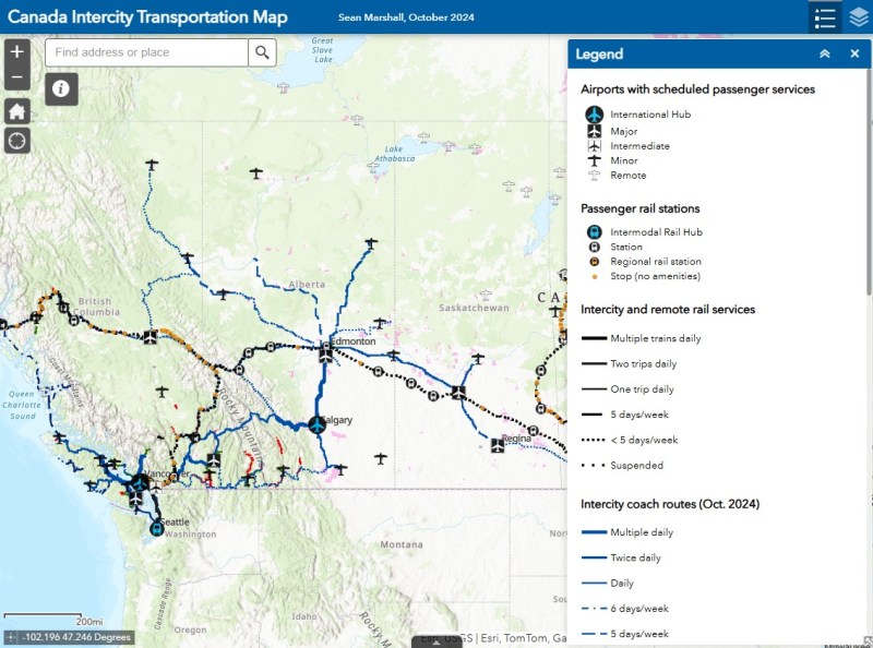
Unfortunately, outside of Ontario, there not that many updates to make. On Vancouver Island, at least, there is now daily service all the way to Port Hardy in the north and Tofino and Ucluelet to the west, with additional runs between Comox, Nanaimo, and Victoria. There are more buses between Vancouver and Seattle; FlixBus is now operating on the busy Calgary-Edmonton and Calgary-Banff routes. There is also a new twice-weekly Edmonton-Camrose service, thanks to work by the University of Alberta’s student union; it partnered with FlixBus to provide the service.
(FlixBus’ Downtown Calgary stop, in a parking lot behind an abandoned building in the Belt Line neigbourhood leaves a lot to be desired. Edmonton’s, at an abandoned car dealer on Jasper Avenue, isn’t any better.)
Also new to the map is Mountain Man Mike’s bus service between Vancouver, Nelson, Kaslo BC, and Calgary, as well as Mobilité Charlevoix, a regional service that connects several towns east of Québec City including Baie-Saint-Paul, La Malbaie, and Clermont.
Unfortunately, several wide gaps remain. Despite plenty of competition on the busiest routes in Southern Ontario and Alberta, there is no bus service between Calgary and Regina, leaving cities like Medicine Hat and Moose Jaw without intercity connections, apart from airport shuttle services, despite once-frequent Greyhound service. Between Winnipeg and Regina, it is still just one bus a week. Maritime Bus, for whatever reason, still has not restored service across the New Brunswick-Québec provincial line.
Without comprehensive government-led coordination and support, these gaps are likely to remain unfilled.
You can read more about how I created these maps here.
If you like this post and you would like to help out with my online mapping and webhosting costs, consider buying me a coffee. Thank you!

4 replies on “Canada Intercity Transport Map, updated for Fall 2024”
Thank you, Sean! Looking forward to more expansion in the future so I can once again (as I did many years ago) make it from Toronto to the Pacific Ocean 100% by bus! Note: It’s Kaslo BC not Kalso BC.
Thank you, Sean! Looking forward to more expansion in the future so I can once again (as I did many years ago) make it from Toronto to the Pacific Ocean 100% by bus! Note: It’s Kaslo BC not Kalso BC.
Thanks – it’s still technically possible, though it requires very good planning to make that once-a-week Rider Express bus between Manitoba and Saskatchewan.
Amazing project, so great and interesting to see!
Would love to know if you could find out more on why Maritime Bus still isn’t heading into Quebec – or Orleans Express into the maritime provinces? I presume some arcane provincial regulatory hang-up?
Currently attempting to construct a bus trip to northern Ontario to visit family and find that the only way to get out of the maritimes by bus is to go to Campbellton and walk across the bridge to Point-à-la-Croix, with an over-night stay in one of the two towns. The afternoon departure from Cross Point means another night in Montreal before the morning bus and a tight connection after fighting rush-hour traffic in Ottawa.
Coming back east is worse, as the only bus south into Ottawa is too late to make a connection to Montreal, but the next morning departure is too late for the connection back to Cross Point. The train doesn’t help.
Wanting to minimise annual leave taken (working while on transit) and GHG emissions (knowing that a Dalhousie Uni study found, hideously, that a flight is greener than a ride on The Canadian) concludes with shelling out $500+ for a Porter flight to Timmins, versus a 3-4 day journey in each direction. Tempting to give hitch-hiking a try, on what should only be 22 hours of driving time!
Aside, are you aware of any attempt to build a nation-wide (ideally US-Canada) trip planner / ticket-purchasing app of sorts (via API/similar, like thetrainline.com in Europe, perhaps?) ? Rome2Rio is clearly missing a few tricks, and it looks like your map could be an amazing place to start!
Moreover, any thoughts on the best government agencies / officials / ministers to write to on this?