Tag: Brampton Transit

  • Brampton Transit’s evolution from a laggard to a leader

    5010657604_d3cd2c355a_o.jpg
    The introduction of Brampton Transit’s Zum service in 2010, serving York University, was a major turning point for the suburban transit agency

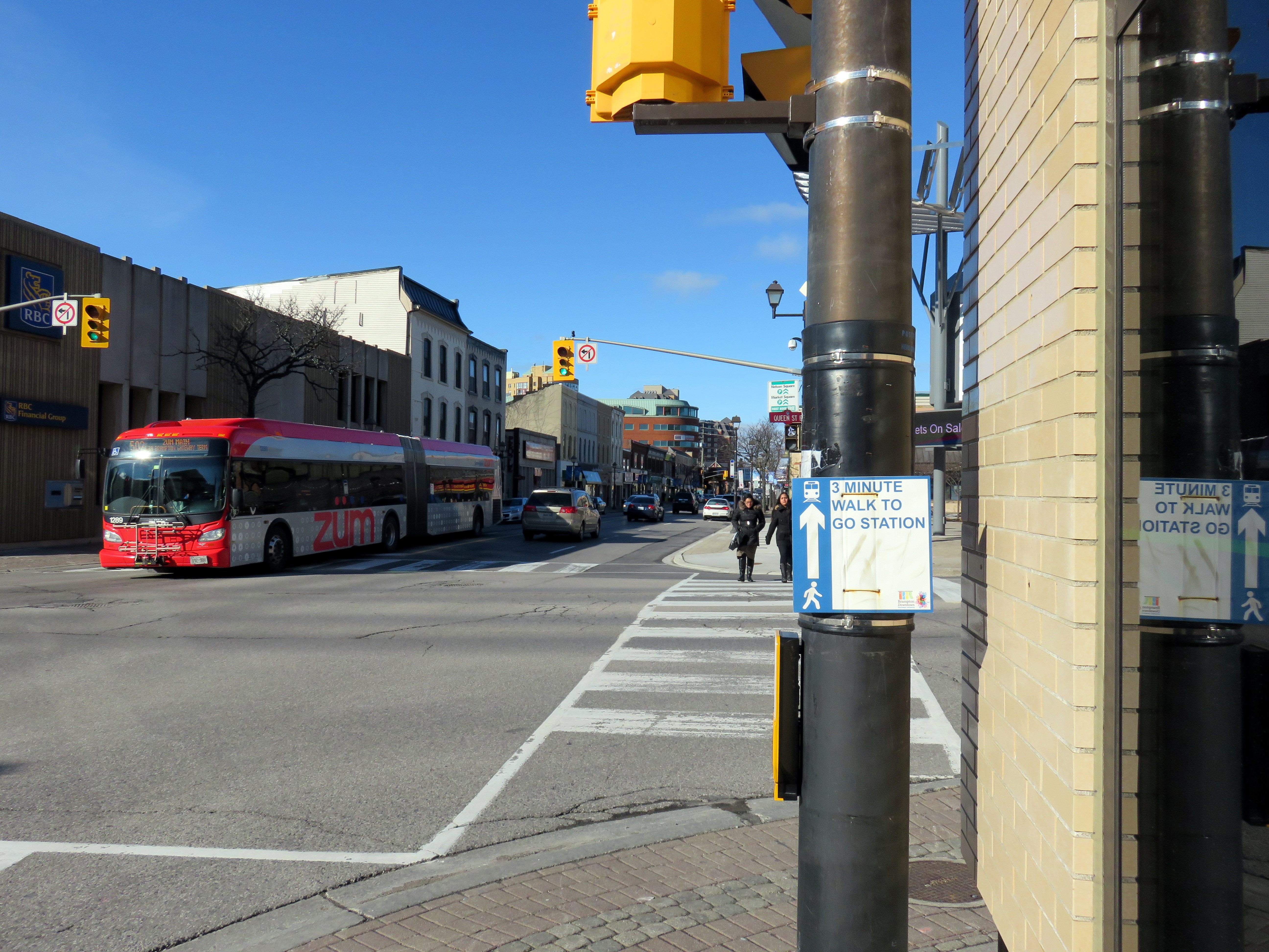
    For TVO this week, I discuss Brampton Transit’s impressive ridership growth. In the last five years, Brampton Transit has bucked the trend of stagnant ridership numbers encountered elsewhere in the Greater Toronto Area and North America in general. I argue that Brampton’s success in improving transit ridership comes from sustained investment over many years, the move to a grid-based route structure, and the introduction of Züm, a basic network of semi-frequent, limited-stop bus routes, many of which extend outside of Brampton’s boundaries.


    I grew up in Brampton, and I have collected maps since kindergarten; my collection includes several old Brampton Transit maps. These maps help to illustrate the progress made since the 1980s, when the level of service provided was quite basic.

    Brampton Transit began operations in 1976 after the old Town of Brampton’s local bus service was amalgamated with the dial-a-bus service operated in Bramalea. (Brampton amalgamated with most of Chinguacousy Township in 1974, including Bramalea.) In 1980, Brampton Transit operated 14 routes, serving a community of just under 150,000 people. Buses operated no later than 9:00 or 10:00 PM, Mondays through Saturdays, and many routes operated with long, meandering loops. Apart from GO Transit, there were no connections to nearby communities.

    Brampton Transit - December 1980 front
    December 1980 Brampton Transit map

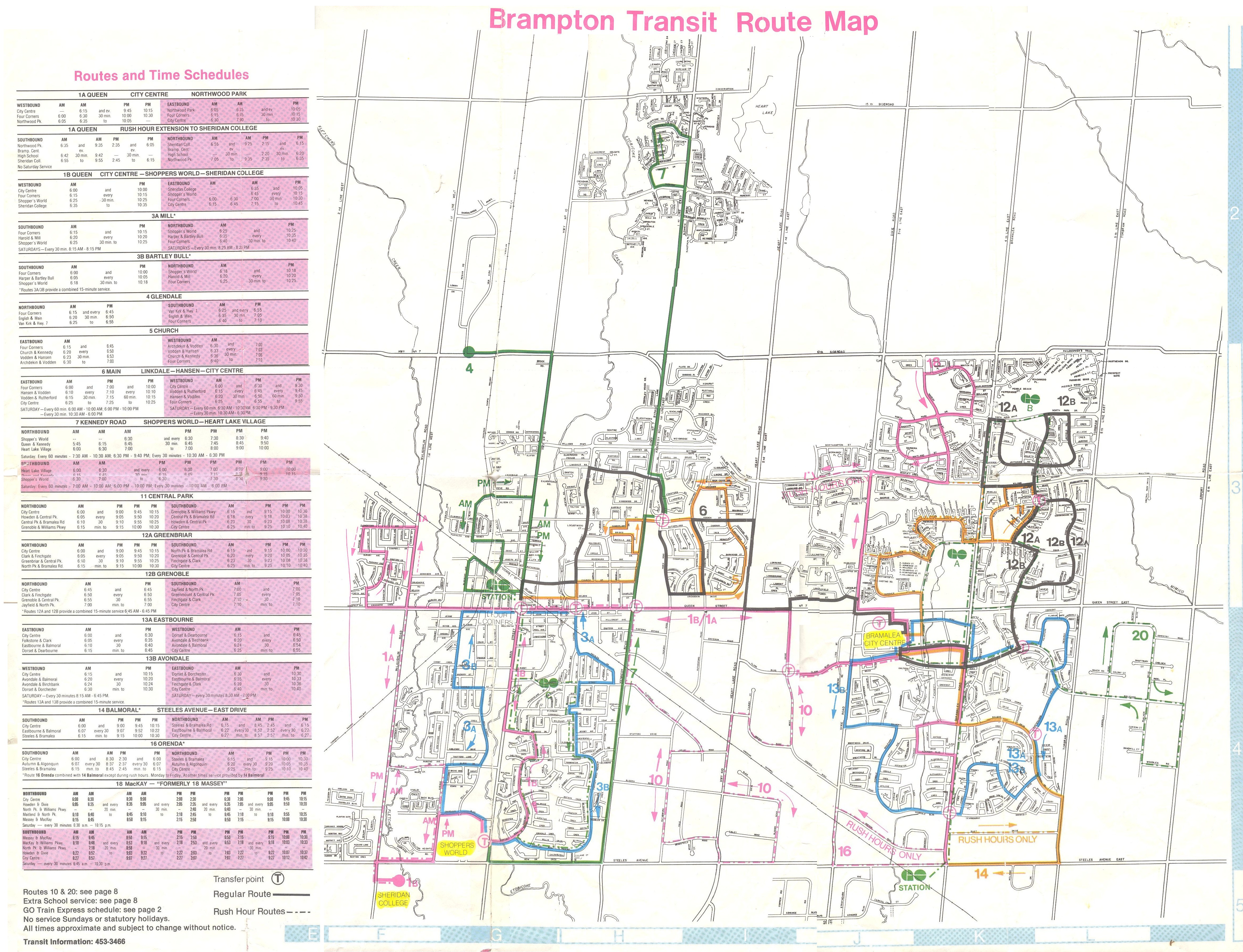
    By 1988, service was offered on Steeles Avenue to Humberline Drive in Etobicoke, where connections could be made to TTC buses on the 96 Wilson and 73 Royal York buses, but didn’t continue east to Humber College. Brampton Transit Route 14 Torbram served Westwood Mall in Mississauga, and connections to Mississauga Transit could be made at Shoppers World. But still, service levels were poor — you were lucky to get a bus every 30 minutes outside of rush hours. Permanent Sunday service wouldn’t come for another ten years. Notable are the four lettered bus routes — A, B, C, and D — that made direct connections to the four weekday GO train round trips to and from Toronto.

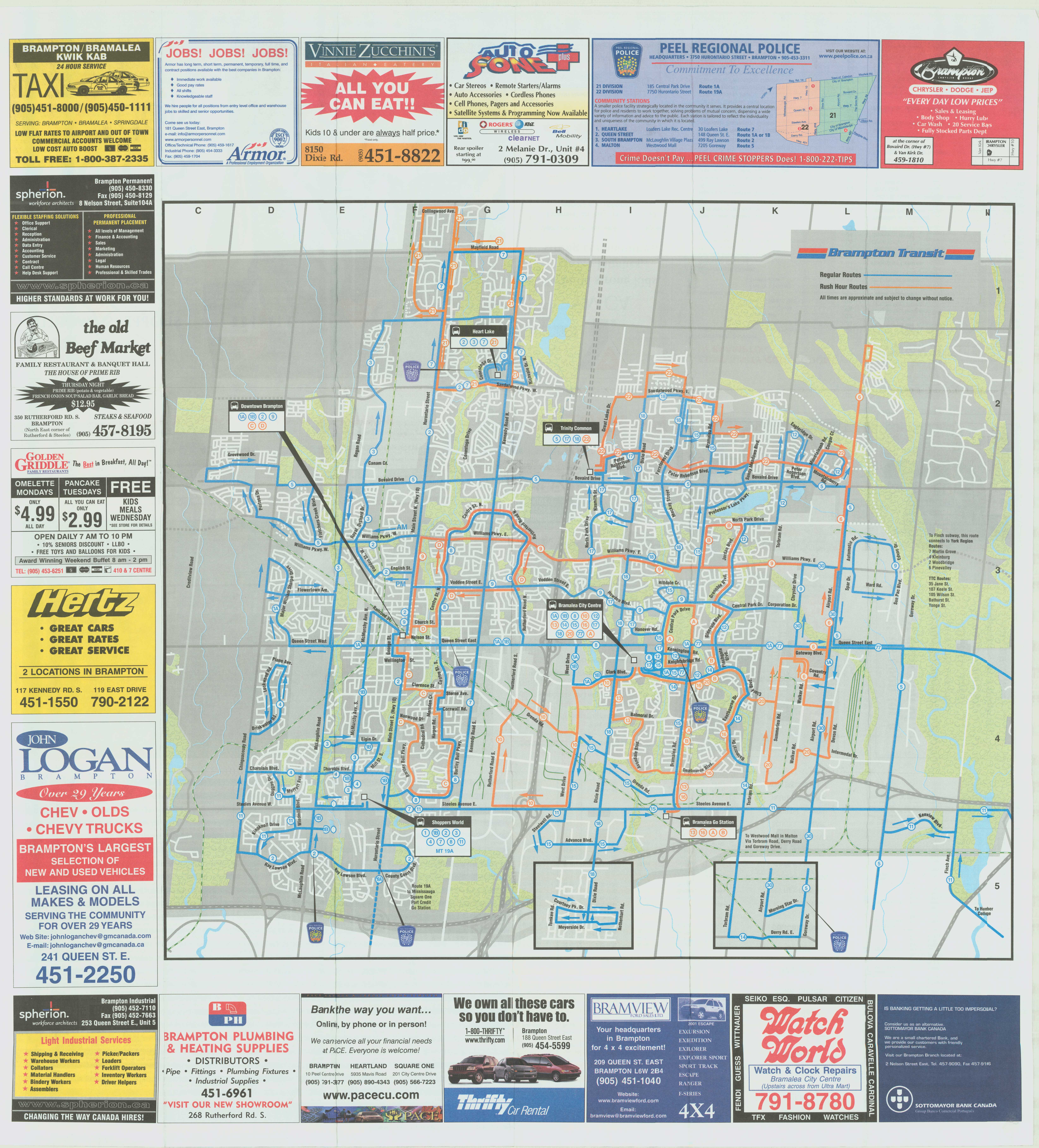
    Brampton Transit’s maps of the era are also historically notable because of their advertising: only one of the Burger King locations shown on the 1988 map still exists. Other restaurants advertised — the Old Beef Market, O’Henry’s, and Queen’s Pizzeria — are no longer in business.

    Brampton Transit - 1988
    September 1988 Brampton Transit Map


    Brampton Transit Maps published in the 1990s and early 2000s were printed on newsprint, and used only a two-colour scheme: blue for regular routes, and orange for rush-hour routes. Service to new subdivisions was often provided by way of long one-way loops, which is an inexpensive way of serving new areas, but are inconvenient and slow for potential riders.

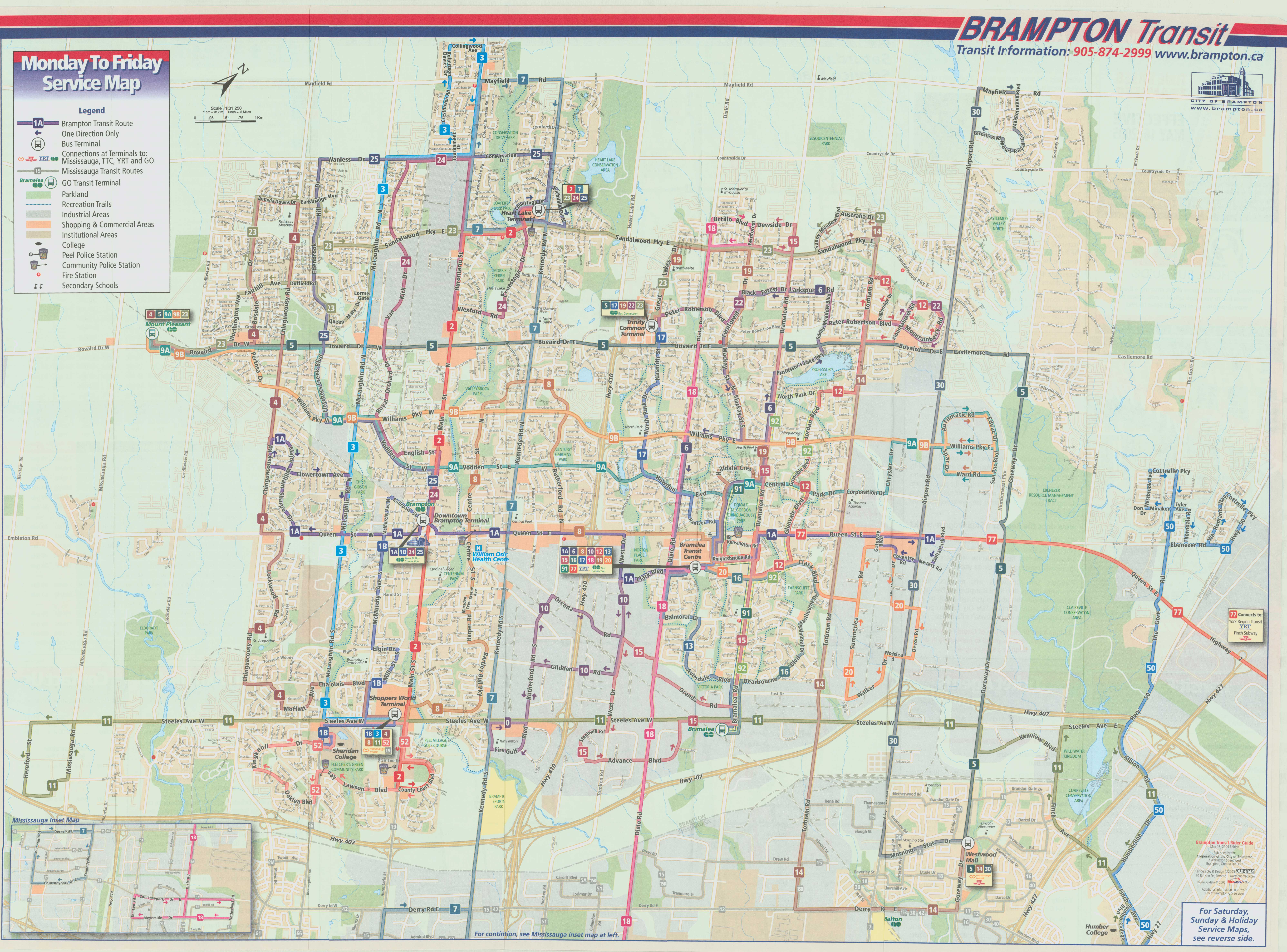
    Notable in the 2001 map below is Route 77, launched in the 1990s as a joint Brampton Transit/Vaughan Transit route between Bramalea City Centre and Finch Station along Highway 7. Route 77 was a very slow way to get to the subway from Brampton, but it operated until Züm began service in 2010. In 2001, bus service on 11 Steeles was finally extended to Humber College’s main campus.

    Brampton Transit, 2002
    September 2001 Brampton Transit map

    2005 marked an important turning point for Brampton Transit, as it introduced a grid-based route system on major arterials. Route 14 Torbram, for example, no longer served Bramalea City Centre, but continued north, providing a core north-south route; many other routes were straightened, including Route 2 Main north of Downtown. Changes since May 2005 saw service frequencies improved, more local routes added, and improved connections.

    Brampton Transit - 2005 front
    May 2005 Brampton Transit map

    The current system map, dated September 2017, can be found on Brampton Transit’s website.

  • New TTC subway stations have great architecture, but they may not attract enough riders

    IMG_4071-001.JPGVaughan Metropolitan Centre Station

    On Saturday, October 28, the Toronto Transit Commission (TTC) held open houses at three of the six new subway stations set to open on December 17, 2017 when the Line 1 subway is extended to York University and Vaughan. It was a fun afternoon with friends, checking out the architecture and the layout of Vaughan Metropolitan Centre,* Highway 407, and Pioneer Village Stations.

    Some of the station architecture was stunning, and I came away feeling much less skeptical about Vaughan’s commitment to building a new urban district around its station. Most stations along the subway corridor will be well-used. However, I remain critical about the issue of transfers between transit agencies, and the usefulness of at least one station.

    (more…)

  • Unanswered questions about Toronto’s next subway extension

    IMG_4677-001.JPGPioneer Village Station under construction, August 2016

    Note: I posted an update to this article on October 4, 2017 

    By the end of next year, the Toronto Transit Commission (TTC) Line 1 subway extension to Vaughan will finally open, two years later than originally planned. The line will provide relief for thousands of York University students and employees and improve service to transit-starved northwest Toronto. It will terminate at Highway 7 in Vaughan, at the ambitiously (and in my view, ridiculously) named Vaughan Metropolitan Station, posing a challenge to cartographers and designers everywhere.

    When the $3.2 billion subway extension begins operating in December 2o17, it will be the first new major subway project since the opening of the five stop Sheppard Subway in 2002. It is also the first subway line to cross the City of Toronto boundary. (Coincidentally, this subway extension will cost the same as the proposed one-stop extension of Line 2 to Scarborough Centre.)

    Aside from the delays, the big price tag, and the silly Vaughan station name, there are two more issues that will arise, and which have yet to be completely figured out: how four separate transit agencies will re-route their buses once the subway opens, and the necessary question of fare integration once that happens.

    (more…)

  • Shortsighted short-turns at Bramalea GO

    IMG_2321-001Bramalea GO Station

    Earlier this week, I took a train from Union Station to Bramalea, as I was preparing for a walk that I will hosting on Sunday exploring Canada’s first satellite city.

    Bramalea Station opened in 1973 when the Georgetown GO train service — GO Transit’s second commuter rail line — was inaugurated. The station is located at the southwest corner of Steeles Avenue and Bramalea Road, surrounded by factories, warehouses and busy roads and highways.

    There’s little to fault GO Transit for locating its station where it is. In 1973, GO was still in its infancy, launching its first rail services along the Lakeshore Line in 1967. It wasn’t anything more than a commuter rail service, offering downtown-bound commuters an alternative to driving all the way in; free and ample parking was part of that successful model. In 1967, GO Transit was created to reduce the need to upgrade provincial highways; it allowed Downtown Toronto to become a bustling global financial centre without needing huge parking lots and garages and more freeways feeding into it; .

    The GO station is located in Bramalea’s south end, next to the CN mainline, surrounded by land designated for industrial development since 1959, when work began on that new suburb. The station is located near a waste-to-energy plant (an incinerator), and is located under Pearson Airport’s flight paths. Since GO insists on providing free parking to its customers, Bramalea (unlike, say, Downtown Brampton) isn’t a bad place to put lots of parking spots; in total, Bramalea has 2,377 parking spots. And since Bramalea Station is adjacent to Highway 407, it’s a major transfer point for GO bus routes to York University, Hamilton, Guelph and Kitchener.

    But like too many GO stations, Bramalea is needlessly hostile to pedestrians and cyclists, and is even hostile for many local transit users. As Metrolinx, the agency responsible for GO Transit, pursues Regional Express Rail (RER), it has a responsibility to improve Bramalea Station. As it exists right now, Bramalea is a terrible transit terminal.

    (more…)

  • The many challenges of creating a transit hub at Pearson Airport

    7afe7e75-d368-4472-b208-ab02c57457aa-001
    Sign in Terminal 1 at Pearson Airport. Whether we realize it or not, Pearson Airport is already a transit hub. 

    Updated April 7, 2016

    Lester B. Pearson International Airport is Canada’s busiest airport, handling 41 million passengers a year. It is not the busiest transportation hub in the Greater Toronto Area, though; Union Station is considerably busier (GO Transit alone handles 64.4 million passengers a year at Canada’s busiest station).

    Pearson Airport is located almost entirely within the City of Mississauga, but the terminals are less than a kilometre away fromthe City of Toronto’s western boundary; due to the location of the airport terminals, most passengers reaching the airport by road, or transit pass through the City of Toronto to get to it.

    The Greater Toronto Airports Authority (GTAA), the not-for-profit agency that operates Canada’s busiest airport, has expressed interest in creating a transit hub and guiding transit-oriented development around it. It’s an interesting idea, and some of the facts are compelling.

    There are approximately 300,000 jobs located at and near Pearson Airport. The airport itself hosts 40,000 employees that work for the airport authority and its contractors and tenants, including retailers, airlines, and allied services. The remaining 250,000 jobs are located in office parks and industrial areas that surround the airport, in the cities of Toronto, Mississauga, and Brampton, a very large area that extends north into Bramalea, west of Hurontario Street and south to Highway 403.

    You can read the GTAA’s report, written by the prestigious planning firm Urban Strategies Inc., and named Pearson Connects: A Multi-Modal Platform for Prosperity online as a PDF. The report claims that Pearson Airport and environs has more jobs, and more economic clout than any Canadian downtown, with the exception of Downtown Toronto. To a degree, this is true. But the size of the Airport Employment Zone, as the GTAA defines it, is much larger in size than any downtown, even Toronto’s; the jobs are mostly dispersed in warehouses, factories, and suburban office buildings difficult to reach by transit.

    In fact, Pearson Airport and its surrounding area — all 25,600 hectares  (256 square kilometres) — has fewer than 25 employees per hectare, while Downtown Toronto, one-tenth the size, has nearly 200 employees per hectare (and a growing residential population as well). Igor Dragovic calculated these figures from a recent Neptis report. The low employment densities found in business parks and warehouse districts are only partly to blame; the airport itself, with five active runways and a large land buffer, contributes to this.


    The GTAA wants to build an “airport-related multi-modal hub” that would tie together existing and planned rapid transit services, including the Kitchener RER Service, LRTs on Eglinton and Finch Avenues, the Mississauga Transitway BRT and a proposed Derry Road transit corridor.  It cites airports in Amsterdam, Frankfurt, London, and Hong Kong as examples to emulate.

    GTAA ProposedThe GTAA’s proposal for a transit hub, taken from Page 7 of the report

    The report also neglects to recognize that Pearson Airport is already a major transit hub; the problems lie in integrating the existing and proposed transit services together. And for an area the size of the GTAA’s Airport Employment Zone, that’s a very tall order.

    (more…)

  • The terminus of the Hurontario LRT: an opportunity for something better

    IMG_8755-001
    Downtown Brampton, the logical terminus of the Hurontario-Main LRT

    I’ve written several times about the Hurontario-Main light rail transit (LRT) project on this blog. Last summer, I led a walk along Main Street, discussing Downtown Brampton’s wonderful built heritage, the potential for Main Street, and explaining why alternative routes, proposed by councillors and private interests, weren’t feasible. Floodplains aren’t great places to build higher-order transit lines.

    Needless to say, I was very disappointed that Brampton City Council voted 6-5 last October against building the LRT between Steeles Avenue and Downtown Brampton. A vocal and wealthy minority, including a former premier of Ontario, opposed the project; it didn’t help that Mayor Linda Jeffrey found herself in constant opposition with several city councillors who backed other candidates for mayor in the 2014 municipal election. A Toronto Star reporter, assigned to the western GTA beat, wasn’t reporting fairly on this issue either.

    Since that unfortunate vote, I resigned myself to a truncated Hurontario-Main LRT corridor that will still serve three or four stops in Brampton, but will stop short of its logical terminus.

    I recently made a trip out to the intersection of Steeles Avenue and Main and Hurontario Streets, the new northern terminus of the planned LRT. Construction of the 20-kilometre line, between Port Credit and Steeles Avenue, is scheduled to begin in 2018.

    HMLRT
    The Hurontario-Main LRT, after Brampton City Council’s vote in October 2015. 

    The corner of Steeles Avenue and Main Street is already a major transit hub. Eleven Brampton Transit bus routes (including two Züm routes), a Miway express bus, and GO Transit buses serve the corner; the Brampton Gateway Terminal is the city’s second-busiest transfer point. The new Gateway Terminal, which opened in 2014, was built to accommodate ridership growth and facilitate transfers with the proposed LRT, which will stop in the median of Main Street.

    As far as Toronto’s suburbs go, this corner of Brampton is relatively dense. There are several rental towers within a short walking distance; there are also three nearby townhouse complexes. Shoppers World, on the northeast corner, is a large regional shopping centre, albeit a mall that has fallen on hard times. On the southwest corner, there is still an old farmfield, surrounded by subdivisions, apartment towers and retail. There are many opportunities for transit-oriented development.

    IMG_8803-001A fallow farm field, south of Shoppers World. The area is zoned for medium and high density housing developments, including townhouses and apartment buildings. 

    If Downtown Brampton, Brampton’s busiest bus route (501 Queen) and a GO Transit and VIA Rail station weren’t just 3 kilometres away, this would actually be an ideal terminus for a suburban light rail transit line.

    IMG_8776-001The corner of Steeles and Hurontario/Main, looking northwest. The Brampton Gateway Terminal is on the opposite corner.

    One of the greatest opportunities for new transit-oriented development is Shoppers World Brampton. First opened in 1969 by Peel Elder Limited (who also developed Shoppers World Danforth), the mall went through several additions over the years; by the 1980s, it boasted over 200 stores, including a Simpson’s, K-Mart, Pascal Hardware, cinemas, and two supermarkets. At one time, Shoppers World even had indoor waterslides. By 2000, Simpsons became The Bay, and K-Mart became Zellers.

    Growing up only a 15-minute walk away, Shoppers World was my local mall. Pizza Hut was a favourite place to meet up with friends, I fondly remember the free popcorn at Jumbo Video, and the bus terminal made it easy to get to better malls, particularly Square One. My first paying gig was returning abandoned shopping carts to K-Mart for $5 each.

    By the 1990s, the mall’s owners neglected the property, while Bramalea City Centre and Square One renovated and expanded. There were persistent rumours that the mall would be closed and re-developed with highrise towers.

    IMG_8782-001A mostly empty Shoppers World parking lot on a Saturday afternoon.

    RioCan REIT took over Shoppers World Brampton in 2000, renovated the property, and added new big-box retailers such as Canadian Tire. But The Bay closed in 2007, and Target, which took over Zellers’ lease, shut down last year. The final indignity came when the shuttered Bay store was torn down and replaced by Lastman’s Bad Boy.

    Shoppers World isn’t yet a dead mall – while many national chains left in the last two decades, small businesses have moved in. However, there are still plenty of vacancies, especially in the north end of the mall, near where The Bay used to be. The new Bad Boy and Beer Store are accessed only from outside the mall, making it harder to draw customers in.

    IMG_2887-001The former mall entrance to Target, showing the floor tiles installed in the 2000-2002 renovations.

    The answer, I think, is to partially redevelop Shoppers World into a mixed-use, transit-oriented development, retaining a majority of the retail space, but including new residential, office and community uses. Shops at Don Mills, at Don Mills Road and Lawrence Avenue in Toronto, isn’t a bad model to follow, but better residential integration and a proper link with the transit hub would be necessary. Humbertown, a smaller, but controversial development proposed for Etobicoke, has the right mix of retail and residential intensification.

    One day, I believe a new Brampton City Council will come to its senses and get the LRT extended to Downtown Brampton as proposed. This is what happened in Mesa, Arizona, a Phoenix suburb that originally opposed a light rail corridor from Downtown Phoenix, Tempe, and Arizona State University, to its downtown. After the first phase of the Valley Metro LRT opened in December 2008, political opposition to a light rail extension along Main Street faded. The LRT through Downtown Mesa opened to great fanfare in August, 2015.

    But until that time comes, there are some opportunities to capitalize on the approved plan. Steeles Avenue isn’t the ideal place to end the Hurontario LRT, but it’s a good place to start planning something better.

  • The challenge of getting to the bus stop

    IMG_8796-001

    It’s time for a rant on suburban transit, and how unnecessarily difficult it can be to get to the nearest bus stop.

    Transit has a harder time in the suburbs. Population densities are lower than in neighbourhoods developed before the Second World War. Suburbs are not only built for the car, but they’re laid out with crescents, cul-de-sacs and winding street systems meant to discourage through traffic in residential areas. Backyard fences line arterial roads, safe pedestrian crossings might be a ten or fifteen minute walk down the road. These factors can make it difficult for people living in subdivisions and near busy streets to easily access a nearby bus stop.

    Last year, Streetsblog USA asked its readers to vote for the sorriest bus stop in America, and some of the submissions are truly awful. But in the Greater Toronto Area, there are many examples of poorly designed or located bus stops. Intersections like the one at Steeles Avenue West and McMurchy/Malta Avenue in Brampton, which, granted isn’t as bad as the StreetsblogUSA submissions, is just one example of how not to get people out of cars and onto public transit. Some thought into placing bus stops and improving access to local transit is necessary.

    I like Brampton Transit and what they’ve been doing over the last decade in my hometown. In 2005, the suburban transit agency began to re-organize its routes into a grid system. There were some hiccups: additional transfers, combined with low frequencies made some trips more difficult, but as ridership improved, so did service levels on key corridors. Schedules were adjusted to improve transfers. Connections to Toronto and Mississauga were improved. My hometown’s bus system was no longer a joke.

    Brampton Transit - December 1980 front

    Here’s what Brampton Transit looked like in 1980, marked with meandering routes and one-way loops. The 2015-2016 system map is here [PDF]. 

    In September 2010, Brampton Transit introduced its first “Züm” route, 501 Queen, which connects Downtown Brampton with York University. Like the first phase of York Reigon’s Viva and Durham Region’s Pulse, Züm was developed as a specially-branded limited-stop bus service. Züm stops have special shelters, with real-time schedule information, winter heating. And on sections of Queen Street and Steeles Avenue, special “queue jump” lanes allow buses to by-pass cars and trucks waiting at intersections.

    Services such as Zum and Viva, which operate mostly in mixed traffic should not be mistaken for “bus rapid transit” such as Ottawa’s Transitway or Bogota’s TransMillenio; “BRT-lite” or “quality bus” are more appropriate terms for these routes. Route 501 Queen operates every 15 minutes or better, seven days a week, into the late evenings. It’s proof that quality transit can be operated in Toronto’s suburbs, and be a success.

    Since Route 501 was introduced, three more Züm routes were added: 502 Main, which follows Main and Hurontario Streets as far as the Mississauga City Centre Terminal at Square One, 511 Steeles, and 505 Bovaird. Each of these routes complements an existing local bus route, though the level of service on these other routes are not as high as on Queen Street; Züm service ends sooner in the evenings (though local bus service operates until after midnight) and frequencies are lower.

    With the introduction of Züm, and combined with other service increases, Brampton Transit ridership increased by nearly 30 percent in the last five years (2011-2015). This increase is significantly higher than the rate of Brampton’s population growth over the same time period.

    In September 2015, the 511 Steeles Züm bus was extended west from Shoppers World to Lisgar GO Station in Mississauga; standard Zum shelters were installed along the corridor, including the intersection of McMurchy/Malta Avenues and Steeles. This intersection is only a few hundred metres from where I grew up. The existing bus stops for local bus routes were relocated to the new shelters, like the one seen below.

    IMG_8800-001

    Both bus stops were installed on the east side of the intersection. The trouble is that pedestrian crossings are prohibited on the east side, due to the priority given to motorists at this suburban intersection. Therefore, transit users may have to cross the intersection three times to get to and from their bus; with several rental apartment towers, townhouses, and compact single-family housing, this is not a low-density neighbourhood.

    IMG_8797-001

    From a traffic engineering rationale, this traffic arrangement, which has existed for about a decade, makes sense. The majority of traffic is on busy, six-lane Steeles Avenue. From the north, most traffic on McMurchy Avenue turns east (left) onto Steeles, while Malta Avenue is a short stub, serving a small townhouse development on the south side of Steeles Avenue. Eventually, Malta Avenue will continue south, hooking up with another section of the same street. For now, a dormant farm field separates the two streets and awaits development.

    To facilitate through traffic on Steeles, the cross streets, McMurchy and Malta, are given only green time equivalent to the minimum pedestrian crossing time. And to facilitate the left turns from McMurchy to Steeles, pedestrians are banned from crossing that side of the street. From the viewpoint of a traffic engineer, this makes sense, but it’s a mindset that ignores the needs of pedestrians and transit customers, and with the re-location of the bus stops, this has become more of a problem. This intersection is owned and maintained by the Region of Peel, not the City of Brampton, as Steeles is a regional road.

    There are two options here, and at other places where people must give way to cars:

    1. Allow pedestrians to cross at all four sides of the intersection, ignoring, for a minute, the desire for cars and trucks to move through with minimal disruption; or
    2. Move the bus stops to the west side of the intersection, minimizing the inconvenience for transit riders.

    Brampton Transit has done a fine job growing its ridership over the last decade, making it a bit easier to get around Toronto’s second-largest suburb without a car. But situations like these, where pedestrian access can be improved, are low-hanging fruit that would demonstrate that transit users are valued, even in the car-dependent suburbs. The current arrangement is unacceptable. Brampton and Peel Region should do better.

    There are plenty of cases elsewhere where there are poorly-located transit stops. One example here in Toronto is the eastbound stop for the TTC’s 42A Cummer bus at McNicoll Avenue at Boxdene Avenue in north Scarborough. There’s no sidewalk on the south side of McNicoll, and Boxdene runs north. Anyone attempting to use this stop is at the mercy of traffic on this busy, four lane road.

    Overall, I would like to see more thought put into locating bus stops in general and making sure they’re easily accessible.