Tag: Streetcars

  • The last run of the Rogers Road Streetcar

    f1526_fl0072_it0061-600x418.jpg
    Westbound Rogers Road Streetcar at Old Weston Road, 1972. Photograph from Toronto Archives – Fonds 1526, File 72, Item 61

    Forty-five years ago today, on Friday, July 19, 1974, the Rogers Road Streetcar made its last run. The route ran from a loop at St. Clair and Oakwood Avenue to Bicknell Loop, located on Rogers Road just west of Keele Street.

    The Toronto Transit Commission (TTC) had only recently abandoned its policy of eliminating the streetcar network in favour of buses and the planned Queen Street Subway. By the early 1970s, there were still nine streetcar lines in Toronto, along with two extra rush hour services.

    The TTC had to maintain a core fleet of streetcars to continue service until a new fleet could be delivered, and there was a shortage of streetcars in good condition. Despite the new commitment to continue operating a street railway, one more line would have to go. Rogers Road, the last of four streetcars operated for the Township (later Borough) of York, would be sacrificed. (It would not be the last streetcar route to disappear, however.)

    For nearly thirty years, service on Rogers Road was provided by trolley buses, a branch of the 63 Ossington route. While the TTC promised to extend the trolley bus to Jane Street (which was one of the reasons why York politicians supported the streetcar abandonment), it never happened. Instead, a shuttle bus route provided service along Alliance Avenue to Jane. Once the trolley bus network was scrapped in 1993, the TTC restructured several west-end routes. In 1994, the 161 Rogers Road bus finally provided the through service York had demanded for twenty years.

    In July 2014, before I started this blog, I wrote an article about the Rogers Road Streetcar for Spacing’s website, with the assistance of Steve Munro and author John F. Bromley. Five years later, it remains one of my favourite writing assignments.

    You can read the Spacing full article on here.

  • The streetcars of Hiroshima: a symbol of resilience

    The Hiroshima Peace Memorial (A-Bomb Dome), with modern Hiroshima rising beyond. Despite its fame, there’s so much more to the city than the memorials.

    My wife and I recently came back from an 18-day trip to Japan. It was my first time visiting the country. We stayed in three cities: Tokyo, Kyoto, and Hiroshima, though we made good use of our Japan Rail Passes and made several day trips as well.

    Despite hundreds of years of history, Hiroshima is best known as the city upon which the United States dropped the first atomic bomb on August 6, 1945, in the final weeks of the Second World War. The memorial (originally the Hiroshima Prefectural Industrial Promotion Hall, but widely known as the A-Bomb Dome) is a UNESCO World Heritage Site, and stands as a reminder of the destructive force and tragedy of modern warfare.

    Most tourists to Hiroshima may only visit the Peace Memorial Park and associated memorials, or take a ferry to Miyajima to visit Itsukushima Shrine and its famous floating gate. But what’s remarkable about Hiroshima is the city’s resilience and pride, and there is much more to see, do, and taste. For me, one of those things is the city’s streetcars.

    The Hiroshima Electric Railway, known as Hiroden for short, operates Japan’s largest street railway network, as well as many local buses and ferries. While most Japanese cities abandoned their streetcars after the Second World War, Hiroshima made a conscious decision to retain its streetcars; they are a symbol of Hiroshima’s resilience. Though 108 out of Hiroden’s 123 streetcars were damaged or destroyed, seven days after the blast, service resumed on the suburban Miyajima line.

    IMG_0264-001Map of the Hiroden streetcar network, with information in Japanese, English, Korean and simplified Chinese

    Today, Hiroden operates 271 streetcars, and it has an eclectic fleet. All streetcars are double-ended, and articulated cars operate with both an operator and a conductor. Passengers pay on exit, though customers using a farecard must tap on and off. (The city fare is a flat 180 yen, though an additional fare is charged on the Miyajima Line.)

    IMG_0279-001Two newer Hiroden low-floor streetcars pass each other on Aioi-dori. 

    Among Hiroden’s assets are two vehicles (#651 and #652) that survived the atomic blast. In the 1960s and 1970s, Hiroshima purchased used streetcars from other cities that were abandoning their systems, including Kyoto, Osaka, and Kobe, some of which still operate today. New articulated low-floor streetcars augment the streetcar fleet, providing barrier-free transit. A complete description of the Hiroden fleet is available on the local transportation museum’s website.

    IMG_0794-001Streetcar #1912 was built in 1957 for Kyoto’s municipal railway. It was acquired by Hiroden when Kyoto abandoned its streetcar system in 1978.

    (more…)

  • The story of Toronto’s streetcar “bull’s eyes”

    7566316174_524a59174e_o.jpgReplica of Toronto Railway Company streetcar #327 operates at the Halton County Radial Railway museum, with the unique glass bulbs visible below the metal “Belt Line” sign. Photo taken June 2012

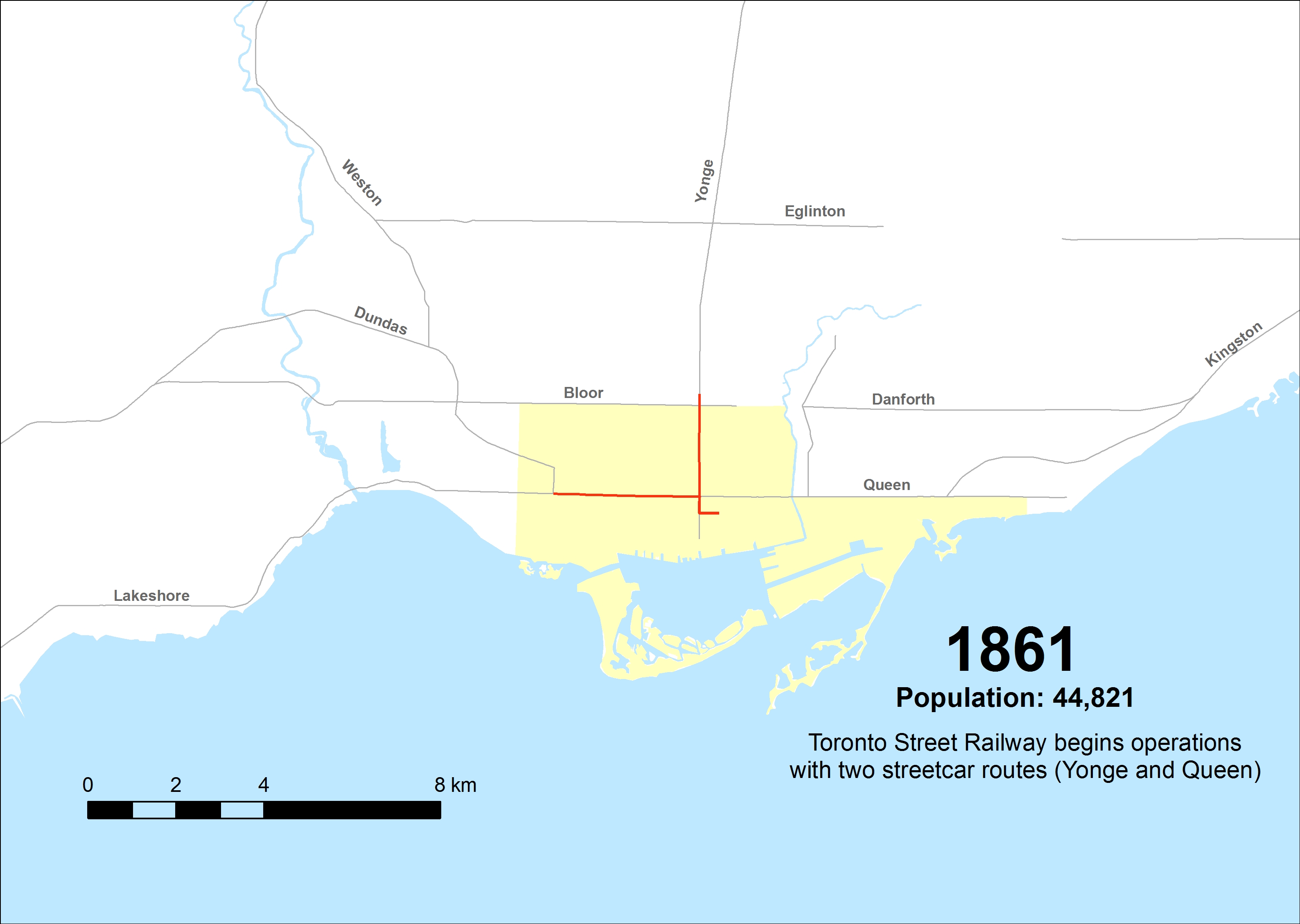
    In 1891, the Toronto Railway Company (TRC) was created, taking over the city’s streetcar system from its predecessor, the Toronto Street Railway. The TRC quickly began electrifying Toronto’s transit network, operating fifteen routes across the city. Electric streetcars were faster than horse-drawn trams, and passengers had difficulties figuring out which streetcar was theirs at night.

    This was a problem as many streetcar routes overlapped. For example, Dupont and Avenue Road streetcars operated on Yonge Street south of Bloor, and Belt Line and Yonge streetcars both ran on Front Street. While the TRC had metal signs on the top and sides of each streetcar to denote the route, they weren’t illuminated. With electric light still in its infancy — arc lamps were too intense while early incandescent lamps were too dull to adequately illuminate route signs — the TRC developed an ingenious solution: uniquely coloured glass bulbs mounted on the roof, lit by interior lights. These lights became known as “bull’s eyes.”

    Under this scheme, the Yonge Streetcar could be identified by one blue light, while the Broadview Streetcar could be identified with red and green lights. This system required passengers to memorize their route’s colours, and as new routes were introduced, changed, or withdrawn, it became cumbersome. Eventually, lighting technology caught up: while back-lit destination signs were possible by 1910, the TRC became hesitant to spend any capital funds to modernize its fleet or expand the streetcar railway network. The City of Toronto was forced to start its own streetcar system, the Toronto Civic Railway, to serve outlying neighbourhoods.

    Though the Ontario Railway Board (predecessor to the Ontario Municipal Board) refused to force the TRC to expand the street railway network beyond the 1891 boundaries, it ordered the TRC to install backlit route signs. These new signs were introduced in February 1913, and those unique coloured bulbs disappeared by 1915. Six years later, the TRC’s franchise was up, and the city-owned Toronto Transportation Commission came into being.

    In 1935, the TTC re-introduced “bull’s eyes” to its streetcar fleet. Officially known as an advance light, a single roof-mounted light, which gave off a blue-green hue, was designed to let waiting passengers know a streetcar was on its way. At the same time, the TTC installed dash lights, which both illuminated advertising cards and provided additional lighting, a useful safety feature.

    IMG_7929-001.JPGTTC PCC Streetcar #4549 on Queen Street West in September 2018

    New PCC streetcars, which began arriving in 1938, were built with the advance lights already installed. By 1940, all streetcars, including the remaining wooden cars acquired from the Toronto Railway Company, were equipped with advance lights. After the Second World War, PCC streetcars purchased from cities such as Cincinnati, St. Louis, and Kansas City, were similarly fitted with the roof-mounted lamps.

    IMG_8717-001.JPGCLRV streetcar on Queen Street East, with two blue-green advance lights above the back-lit destination sign. 

    By the 1970s, the TTC decided to maintain its street railway fleet after planning for their eventual replacement with buses and subways, and sought a replacement fleet for its ageing PCCs. The new Canadian Light Rail Vehicles (CLRVs) and Articulated Light Rail Vehicles (ALRVs) were designed with dual advance lamps, mounted within the streetcar body, immediately above the destination sign.

    Advance lights were introduced to TTC buses starting in the mid-1990s, as new wheelchair-accessible vehicles were added to the fleet, starting with high-floor Orion V and Nova RTS buses, and continuing with newer low-floor vehicles. Blue lights indicated that the bus was accessible. As a bonus, when combined with new digital orange LED destination signs, the bus advance lights served to further improve the visibility of approaching transit vehicles.

    11041809023_47fc64e5e7_o.jpgNova articulated bus with orange LED destination sign and blue LED advance lights indicating it is an accessible vehicle

    The new Bombardier Flexity streetcars are similarly equipped with new blue LED lights, as they too are fully accessible vehicles. While blue advance lights are unique to TTC buses, the new light rail vehicles for Waterloo Region’s ION LRT, also built by Bombardier, sport similar blue lights.

    IMG_8421-002.JPGION LRT vehicle undergoing testing in Kitchener, February 2019

    Sources:
    John F. Bromley and Jack May: Fifty Years of Progressive Transit (Electric Railroaders’ Association, 1973)
    Mike Filey: Not a One-Horse Town: 125 years of Toronto and its Streetcars (Firefly Press, 1990)

  • The streetcar returns to Detroit – but who benefits?

    IMG_1489-001Woodward Avenue at Mack Avenue, August 2017

    I grew up in Brampton, a suburb of Toronto. Our family could not justify long, expensive vacations, but we did make several trips to Detroit and the region, usually to visit the Henry Ford Museum and Greenfield Village. We’d stay at a hotel outside Detroit, usually one with a swimming pool. Besides the museum visit and the pool, my parents would usually include a stop at an outlet mall. We’d also drive through Detroit itself, sparking my enduring fascination with the city.

    Since my first visit in the mid-1980s, the Hudson’s Department Store has been demolished, the Michigan Central Station has been permanently closed and allowed to deteriorate, and several downtown skyscrapers have closed and been abandoned. The city itself continued to lose population as more auto plants closed in the city and surrounding suburbs, and city services declined.

    But on recent trips, on my own or with friends, we started to see the beginnings of what looked like a comeback. New downtown baseball and football stadiums, followed by new office buildings, the re-opening of the long-abandoned Book-Cadillac and Fort Shelby Hotels, the opening of the Detroit Riverwalk and Dequindre Cut multi-use paths, and new residential development Downtown and Midtown.

    On the last trip to Detroit, my wife and I stayed downtown, at a hotel in the David Whitney Building, a formerly-abandoned office tower. We walked around Downtown Detroit and Eastern Market, visited the famous Art Deco Fisher Building, and went to several museums, including the Charles H. Wright Museum of African-American History, and the Detroit Historical Museum, both of which had special exhibitions marking the 50th anniversary of the 1967 Detroit Rebellion (also known as the 12th Street Riot). We ate at great local restaurants as well.

    And I went back to the Henry Ford Museum and Greenfield Village, both of which were as fun and as interesting as I remember.

    We also took the new QLine Streetcar. It was a fun ride, and I’m happy to report that the service was well used by both residents and tourists alike. But I have some serious concerns as well.

    (more…)

  • Mapping Toronto’s street railways in the TTC era (1921-2016)

    Yonge and St Clair, north-west
    Yonge Street at St. Clair Avenue, 1922. The TTC was busy in its first few years joining together the various street railway systems together and expanding services. Here, work is underway to extend city streetcar service to Glen Echo Loop and connect with the former Toronto Civic Railway’s St. Clair line.  City of Toronto Archives Fonds 16, Series 71, Item 1571

    Third in a three-part series — also see Part 1 (1861 to 1891) and Part 2 (1891 to 1921)

    In 1921, the Toronto Transportation Commission was established to provide all transit services within the City of Toronto, on a complete cost-recovery basis. Within the City, there would be a single fare for all regular services, including free transfers, with additional fares for services outside the city limits.

    The TTC immediately took over the operations of the Toronto Railway Company and the city-owned Toronto Civic Railways and began to unify the two systems. It bought new equipment, and replaced worn-out rail, carhouses, and other facilities. It introduced the first transit buses to Torontonians, and three decades later, Canada’s first subway.

    Toronto’s streetcar system expanded through the 1920s, but stagnated through the 1930s, including the loss of almost all of Toronto’s radial railways. But it wasn’t until 1947-1948 that Toronto’s street railway network entered an era of decline, as trolley coaches, diesel buses, and subways chipped away at the streetcar’s dominance.

    By the late 1960s, the TTC was looking to eliminate streetcars entirely by 1980, once the Queen Street Subway opened. Of course, that subway line never opened, and the streetcars remained. It wasn’t until the 1990s, though, that the network entered a renaissance.

    1923

    Within two years, the TTC quickly modernized the streetcar system. New streetcars — known as Peter Witts — were ordered and the oldest of the Toronto Railway Company’s cars were immediately scrapped. The TTC unified the TRC and Civic systems, replaced the radial railways within city limits with city services, and added new routes such as Coxwell and Bay. The City took over the Toronto & York radials as well, but handed their operation over to Ontario Hydro. The TTC also replaced much of the worn out rails, and built new turning loops at the end of streetcar lines replaced crossovers and wyes. This improved operations and allowed for larger, single-ended streetcars to operate on more routes.

    The TTC also introduced buses. In the early 1920s, buses were were slow, small and less comfortable than streetcars, but they had their advantages. The TTC’s first bus route, 1 Humberside, provided a direct, single-fare ride through the South Junction neighbourhood to TTC streetcars at Dundas Street; the Toronto Suburban’s Crescent streetcar line couldn’t compete and was soon abandoned. The TTC also experimented with a trolley bus route on Merton Street and Mount Pleasant Road between 1922 and 1925; it was replaced by an extension of the St. Clair streetcar.

    ttc-streetcars-1923

    s0648_fl0227_id0001Trolley bus on Merton Street, June 20, 1922. City of Toronto Archives, Series 648, Fonds 227, Item 1

    (more…)

  • Mapping Toronto’s streetcar network: The age of electric – 1891 to 1921

    People & Historic shots. - [1920?]-1987

    TRC streetcars on Queen Street, c. 1910. Note the old TSR horsecars used as trailers behind the electric cars. City of Toronto Archives, Series 1465, File 722, Item 18

    This post continues from The Horsecar Era: 1861 to 1891 

    In 1891, after obtaining a new 30-year franchise, the Toronto Railway Company went to work electrifying Toronto’s streetcar system. The TRC was a private company, led by William Mackenzie and James Ross. Mackenzie made his fortune in railway construction; together with Donald Mann, he would go on to build a railway empire before it collapsed by the end of the First World War. Mackenzie would also control other street railway and interurban lines in Ontario, including the Toronto and York, the Toronto Suburban, and the Niagara, St. Catharines, and Toronto.

    By 1894, the TRC became fully electrified, providing quicker and more reliable service. In the twenty-five years that followed, new electric railways radiated out of Toronto to points such as West Hill in Scarborough, Port Credit, Woodbridge, and even as far away as Lake Simcoe and Guelph. But after a short sprint of service expansion within the City of Toronto, the TRC refused to extend its services beyond Toronto’s city borders of 1891. The City of Toronto was forced to form its own public streetcar company in 1911, and became determined to take complete control over urban transportation services once the TRC’s franchise came to an end.

    Maps presented only show revenue routes, including peak period variations and some seasonal routes, such as Exhibition services. I omit some minor service and route changes. I welcome constructive feedback as I plan to re-publish these maps elsewhere.

    1894

    Electrification of the Toronto Railway Company began when the Church Street line was converted on August 16, 1892. The last horsecar made its trip on McCaul Street on July 18, 1894. The TRC extended several routes in Toronto’s west end, including King, Dovercourt, Bloor, Dundas and Carlton.

    The Davenport Street Railway Company began operations on September 6, 1892 between Toronto Junction at Keele and Dundas Streets, and Bathurst Street at the CPR tracks, a short walk to TRC Bathurst Cars. The Weston, High Park & Toronto Street Railway Company began operating the same year within the Junction, from Evelyn Crescent to Keele Street, later extending east to the Toronto City Limits at Humberside Avenue. These two companies merged in 1894 to create the Toronto Suburban Railway.

    The Toronto and Mimico Railway was the city’s second radial. After a troubled start in 1892, it extended west to New Toronto by 1894. The Toronto and York built east from Queen Street and Kingston Road to Blantyre Avenue in Scarborough Township. Two short spurs served the town of East Toronto (near today’s Main/Gerrard intersection) and down to the Beach.

    ttc-streetcars-1894

    (more…)

  • Mapping Toronto’s streetcar network: The horsecar era – 1861 to 1891

    Horse car, with J. Gibbons, conductor, and J. Badgerow, driver, at Old North Toronto StationToronto Street Railway horse car on Yonge Street at the Canadian Pacific Railway crossing, after 1885. From City of Toronto Archives, Fords 16, Series 71, Item 3367

    Over the last few months, I have researched many books and maps and created a series of maps that attempt to illustrate the history of Toronto’s street railways, from 1861 to the present. Toronto is one of only a few cities in North America to continually operate a street railway network (others include Boston, Philadelphia, San Francisco, and New Orleans), which remains one of the busiest and most expansive tram systems in the world.

    Before the Toronto Transportation Commission was created in 1921, Toronto was served by several private streetcar firms. The Toronto Street Railway, which began operations in 1861, built Canada’s first streetcar system; two routes were opened that year, with small railcars pulled by horses. The TSR’s successor, the Toronto Railway Company, electrified the network, but with few exceptions, refused to expand it beyond Toronto’s 1891 borders. Only with the creation of the publicly owned TTC was Toronto’s streetcar system unified and modernized to be the envy of cities across the continent.

    Creating these 38 maps was a challenge, because published materials covering the pre-TTC era (before 1921) are sparse. William Hood’s Street Railways : Toronto: 1861 to 1930 provides some history of Toronto’s earliest transit services, but with only some details. I also consulted Transit Toronto’s route histories and other books such as Robert M. Stamp’s Riding the Radials and John F. Bromley’s Fifty Years of Progressive Transit which covers the years from 1921 to 1971.

    This post, the first of three, will cover the years from 1861 to 1891, the era of the Toronto Street Railway (TSR), when horse power ruled the streets. I do not cover every year, and I omit some minor service and route changes. But this, I hope, accurately illustrates the rise, fall, and renaissance of Toronto’s streetcar system.

    1861
    The TSR begins operations on September 10, 1861, serving a small provincial city of less than 50,000 people. The first route, Yonge, operates from Yorkville Town Hall, just north of the city limits, to St. Lawrence Market at King and Jarvis. A second route, Queen, was established in December of 1861, running between the market and the Ontario Hospital at the corner of Dundas Street, now Ossington Avenue.

    ttc-streetcars-1861

    (more…)

  • A vision for King Street

    21207239313_0c5746b3f8_o

    In today’s Toronto Star, city columnist Ed Keenan reports on the “King Street Visioning Study,” a city planning project that will soon be available for public feedback. The study proposes improving streetcar operations along the King Street Corridor between Dufferin and Parliament Streets as well improving the public realm, making it a more pleasant place to walk. The 504 King Streetcar is the busiest surface route in the TTC’s system, and as I, and many others, have said before, the streetcar needs to be able to move more people more efficiently. But now City Planning is leading the study, not the TTC, making this a more holistic vision for King Street.

    Chief City Planner Jennifer Keesmaat says that it’s “reasonable” that the initial pilot projects could be started in early 2017. Work has already been contracted to some of the same firms that were responsible for transforming Queen’s Quay (which despite some construction delays, and conflicts in a few places between pedestrians, cyclists, and motorists, is a fantastic project).

    Keesmaat echoes previous attempts at creating a King Street Transit Mall, suggesting a similar system of alternating one-way sections that would provide for taxis, deliveries and passenger drop-offs and pick-ups, but forcing through traffic onto parallel streets. Extending transit priority all the way from Dufferin to Parliament could do a lot to streetcar improve operations, especially as the TTC is planning a new 514 route on King between Dufferin and Cherry Streets to supplement the overburdened 504 line and better serve the West Donlands, Distillery District, and Liberty Village.

    Yes, King Street improvements would start off as pilot projects, much like the bicycle lanes on nearby Richmond and Adelaide Streets, or the decade-old 2-hour transfer on St. Clair Avenue, or the Toronto Hydro ALAMP street lighting trials that should have concluded years ago. (Toronto seems to like permanent pilot projects.) That said, previous plans for a King Street transit mall never even got to the “pilot project” phase.

    But hearing that pedestrians and transit will be getting priority is music to my ears. Knowing that City Planning, and not just the TTC, is looking at this gives me optimism that this could finally go ahead. There will be opposition from businesses along the corridor, taxi drivers, suburban politicians concerned about a non-existent “war on the car.” And it’s not clear if Mayor John Tory is in favour, or a majority of city councillors.

    An improved public realm is especially appropriate on King Street, especially through historic Old York on the east and the cultural and tourist draws of the Entertainment District on the west. Sidewalks are often crowded, especially as the theatres get out in the evening, but with such diverse uses along the corridor, from bank towers to night clubs, King is one of Toronto’s most vibrant streets. Toronto often has trouble with attractive streetscaping (thanks to ugly wooden poles and overhead wires, cheap, grey street furniture, and ugly traffic signals), but it has recently managed to get Queen’s Quay (mostly) right.

    As for design, I’m hoping for something interesting and something different. I’d do away with the Muskoka chairs mentioned in Keenan’s article. They’re wonderful on Toronto’s waterfront, but I’d like to see some imagination on King Street. What about seating shaped like director’s chairs in front of the TIFF Lightbox? (Oh, and on the subject of TIFF, could we tell film festival organizers to stuff it when they want to wreck the King Streetcar again in 2016?)

    After years of talk about fixing King Street, there’s a very serious proposal to do something about it. Maybe the third time’s the charm.

  • Mapping an accessible TTC

    IMG_3898

    Last week in Torontoist
    , I wrote about the challenges of getting around on the TTC for passengers who rely on mobility devices, such as wheelchairs. Most of us never think about this problem unless we’re directly affected by the consequences of an inadequate system, as I was after a cycling injury in 2012.

    But for TTC users with mobility disabilities (or even passengers with strollers, wheeled carts, or luggage), it’s an issue. While the bus system is (mostly) fully-accessible, the backlog in the delivery of new streetcars and the installation of elevators in subway stations leaves the system failing many of its riders. The alternative, Wheel-Trans, is also underfunded, inconvenient and useless for last-minute travel plans.

    Here’s what the subway system looks like if you require the use of elevators to navigate the system:

    accessible map - now 2015

    By 2016, only one more station  — St. Clair West  — will be equipped, by 2017, Wilson, Ossington, Coxwell, and Woodbine (and hopefully the Spadina Subway Extension to Vaughan Centre, with its six new fully-accessible stations, will open by then) will follow. But there’s not enough funding to make the entire system accessible by 2025, the deadline set by the Accessibility for Ontarians with Disabilities Act (AODA). Seventeen stations, including Islington and Warden, remain unfunded.

    The entire bus fleet is accessible, though not all bus stops are (the TTC requires a solid, concrete or asphalt place to deploy the ramp or lift, and room for the passenger to board; some suburban stops without a bus pad, or narrow urban sidewalks make loading a passenger in a wheelchair difficult). The first four low-floor streetcars are operating on Spadina Avenue, 200 more are still to be delivered. By now, the Spadina, Bathurst and Harbourfront cars were to have been fully-equipped with the new trams.

    In the meantime, the few bus routes that operate in the central core don’t have many accessible connections; east-west travel is particularly difficult. For example, the 47 Lansdowne bus is inaccessible from either subway station it services (Lansdowne and Yorkdale), and offers no barrier-free transfers south of Dupont Street. The map below shows this problem:

    TTC - Downtown v3 Crop

    Elevators at Ossington would connect the subway with three accessible bus routes, including the 94 Wellesley, a useful east-west alternative. (The 94 serves four subway stations and enters three of them, not one is equipped with elevators.) Meanwhile, both Toronto Western and St. Joseph’s Hospitals are isolated from the accessible transit network.

  • Streetcars of desire: why are American cities obsessed with building trams?

    IMG_5868-001

    Back in January, I posted my thoughts on some of the new streetcar systems being built in the United States after visiting Detroit, Cincinnati, Atlanta and Tampa on a Florida road trip. I soon cross-posted the article to Spacing, where it got more interest.

    Not long after the Spacing cross-post was published, I got a message from Guardian Cities. The editor, Mike Herd, asked me if I was interested in writing a similar piece, expanding on my post and discussing the difference between the streetcars in my hometown of Toronto, and the new systems being built in the US.

    It was an interesting experience, and one where I came to appreciate the role that content editors have. The article went through several major changes until we were all happy with the final product.

    You can read my Guardian Cities article, which was published on Friday, here:

    Streetcars of desire: why are American cities obsessed with building trams?