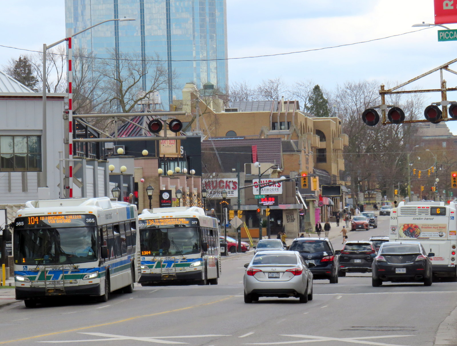
BRT median under construction on Wellington Street at South Street, London
The City of London, Ontario has been quietly constructing a new bus rapid transit (BRT) system over the last few years, which will extend south and east of the downtown core. By the end of April 2025, the first major section of this network will begin operation.
The Wellington Road and Fanshawe College segments are two of the four rapid transit routes originally proposed under London’s SHIFT. At first, a north-to-east line, connecting Masonville Place Mall, Western University, Downtown London, and Fanshawe College, was to be a light rail corridor, featuring a short tunnel under Richmond Street to avoid a busy freight railway crossing. A BRT line would have connected the west end of London, at Oxford Street and Wonderland Road, continued downtown, and head south towards the Victoria Hospital campus and White Oaks Mall near Highway 401. The map below shows the initial proposal.
The original rapid transit proposal called for a light rail (orange route) connecting Western University, downtown, and Fanshawe College and a BRT (blue) corridor to the west and south of downtown
Due to budget constraints, the project was revised to a BRT-only scheme. The Richmond Street leg, leading north to Western University, was cut when the bus tunnel under the CPKC railway and the Oxford Street intersection was deemed to cost $220 million in 2017. Business owners along Richmond Street, a busy restaurant, nightlife, and shopping district known as Richmond Row, were also opposed to the reduction in traffic lanes that the transit tunnel would have required.
This section of Richmond Street — used by eight London Transit routes — is a severe bottleneck as it is not only a busy traffic corridor, it crosses CPKC’s mainline connecting Toronto, Windsor, and the US Midwest.
Several buses cross the CPKC tracks on Richmond Street north of Downtown London
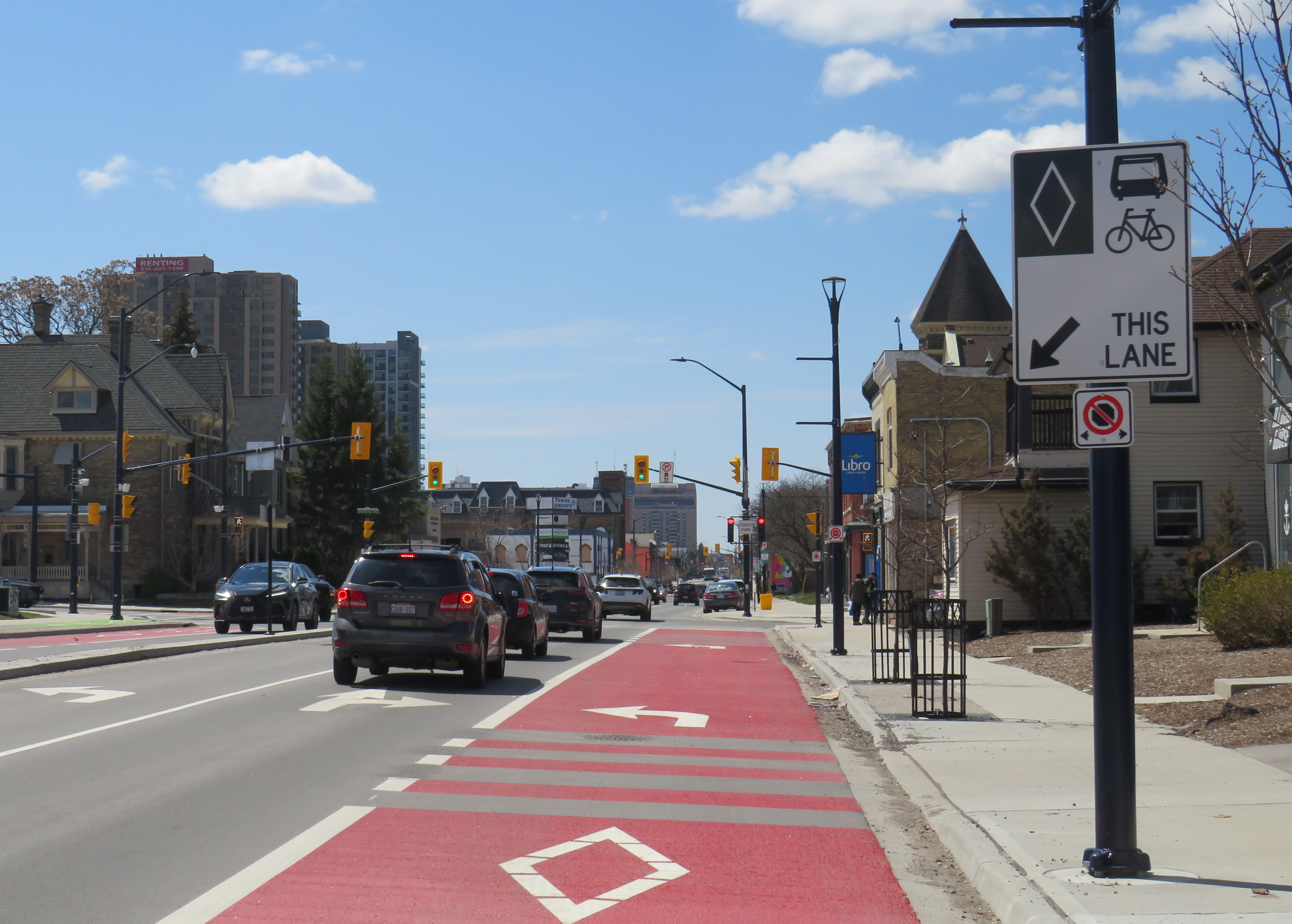
The pared-down BRT project consists of a curbside bus-only lane encircling the downtown core, following King Street, Wellington Street, Queen’s Avenue, and Ridout Street. At each turn, buses must wait for a dedicated signal to make the left turn to continue on the loop. Right now, buses do not have any signal priority, and can wait a full light cycle (up to two minutes) to get the dedicated left turn signal.
Example of a left turn from the right curb lane in London. The dedicated transit signals allow left-turning buses to remain in the right lane without traffic conflicts.
New enlarged shelters and long platforms allow multiple buses to pick up and drop off at each stop; most routes heading through downtown will serve at least one of these new bus stops on their routes. All buses were removed from Dundas Street, which has been re-landscaped to create a more pedestrian-friendly commercial environment called Dundas Place.
New enlarged bus shelters along the BRT corridors; this is at Wellington and King Streets
On April 28, Route 94, a weekday express route between Argyle Mall in London’s east end, Downtown London, and Western University, will begin operating in both directions on King Street, and will be the first route using the bus infrastructure outside the downtown loop. King Street was originally a one-way, two-lane-wide roadway east of Downtown London, but was recently widened to allow for painted bus lanes in both directions.
Contraflow bus lane on King Street, previously a two-lane, one-way street
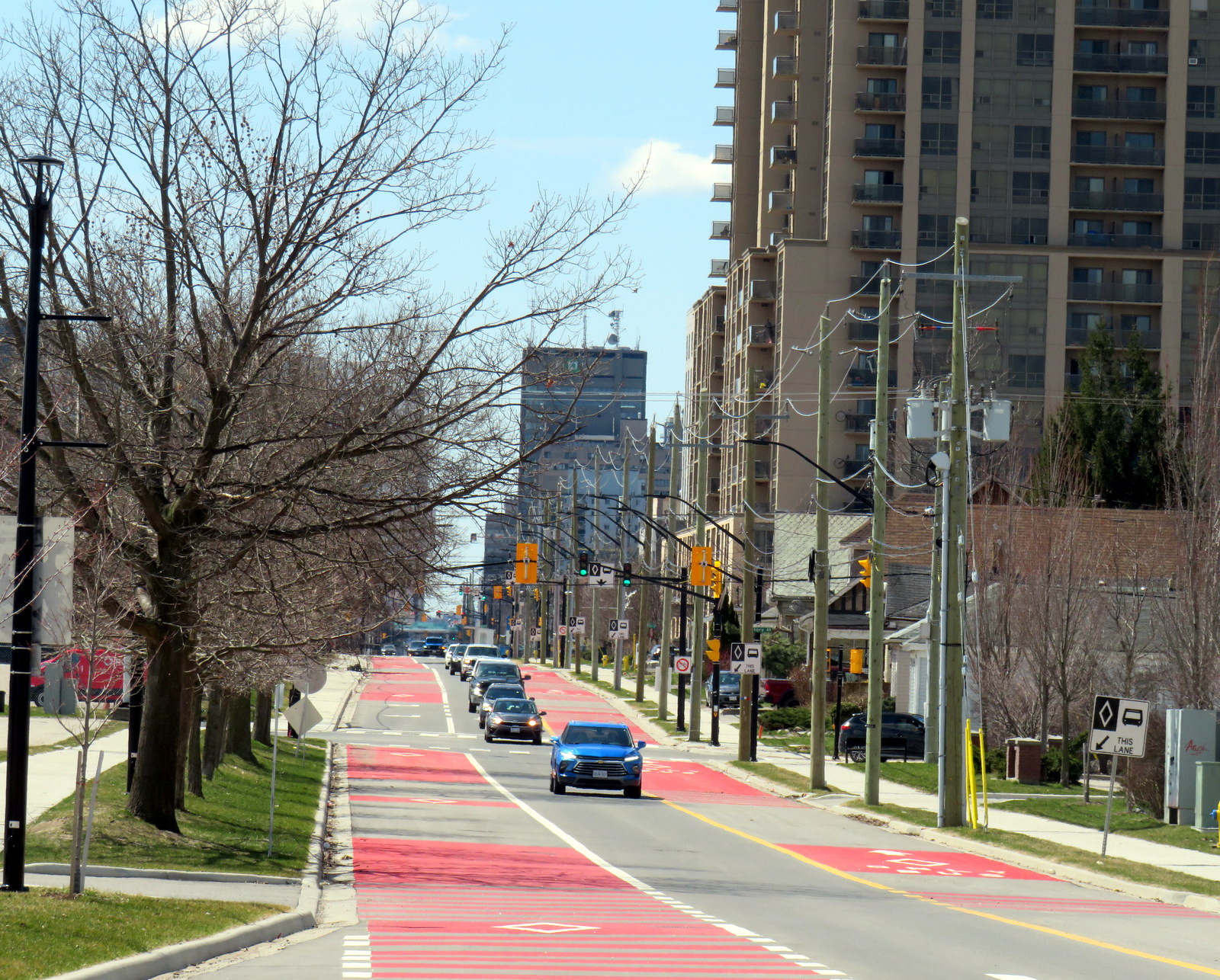
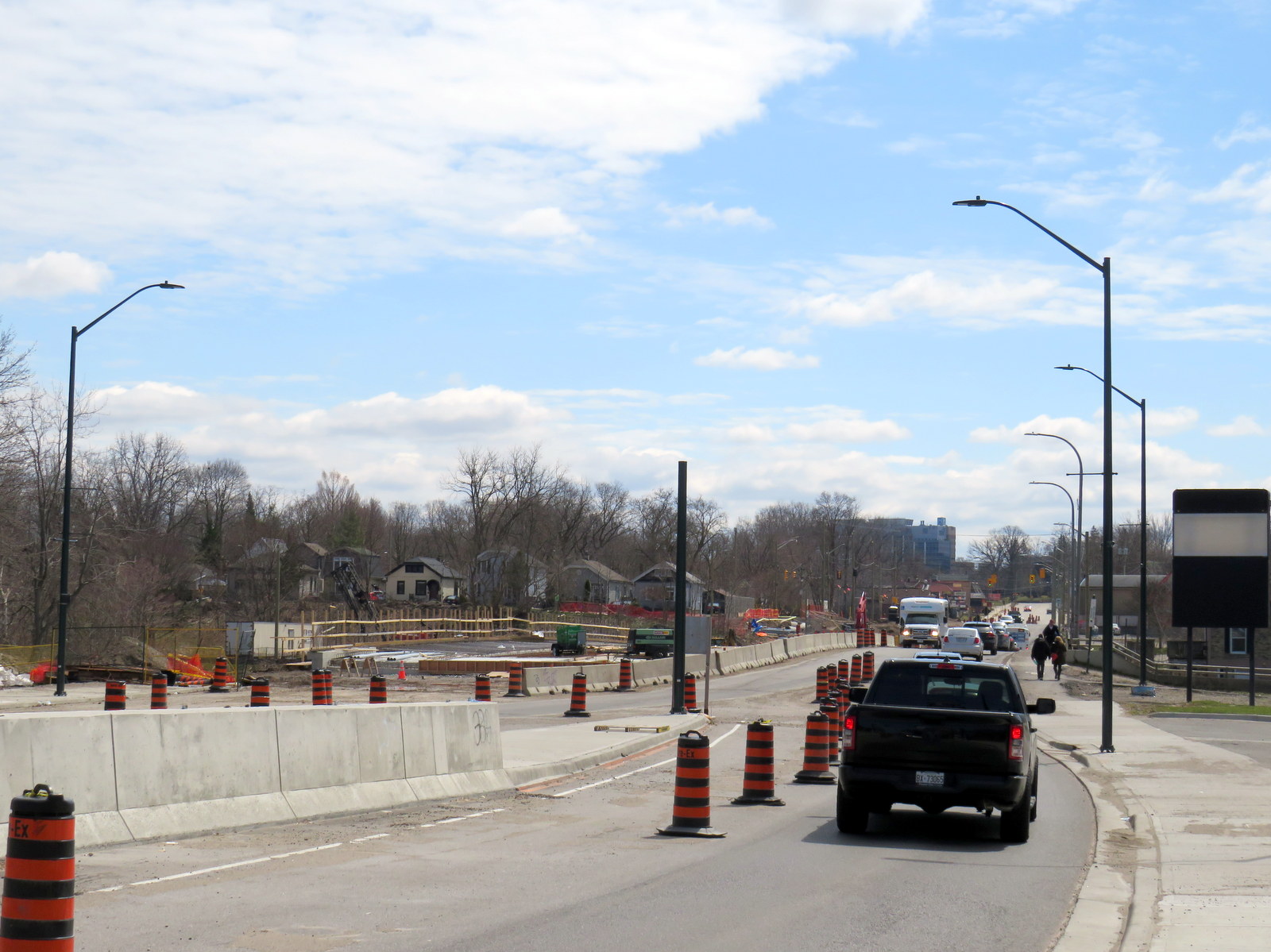
Work is far from complete. Utility work and road reconstruction continues on Dundas east of Ontario Street (at the Western Fairgrounds) and on Highbury Avenue north to Oxford. Construction of the BRT median on Wellington Street/Wellington Road south is also ongoing.
Looking south on Wellington Street at the South Thames River bridge crossing, which is being widened as part of the BRT project
The cost of the BRT project has risen to at least $454 million, and that does not include the north or west segments. Service levels have yet to be determined, along with transit route restructuring once the east and south segments are complete. The new station shelters will not have off-board fare payment equipment, so unless policy changes, all transit riders will still have to enter the bus from the front door.
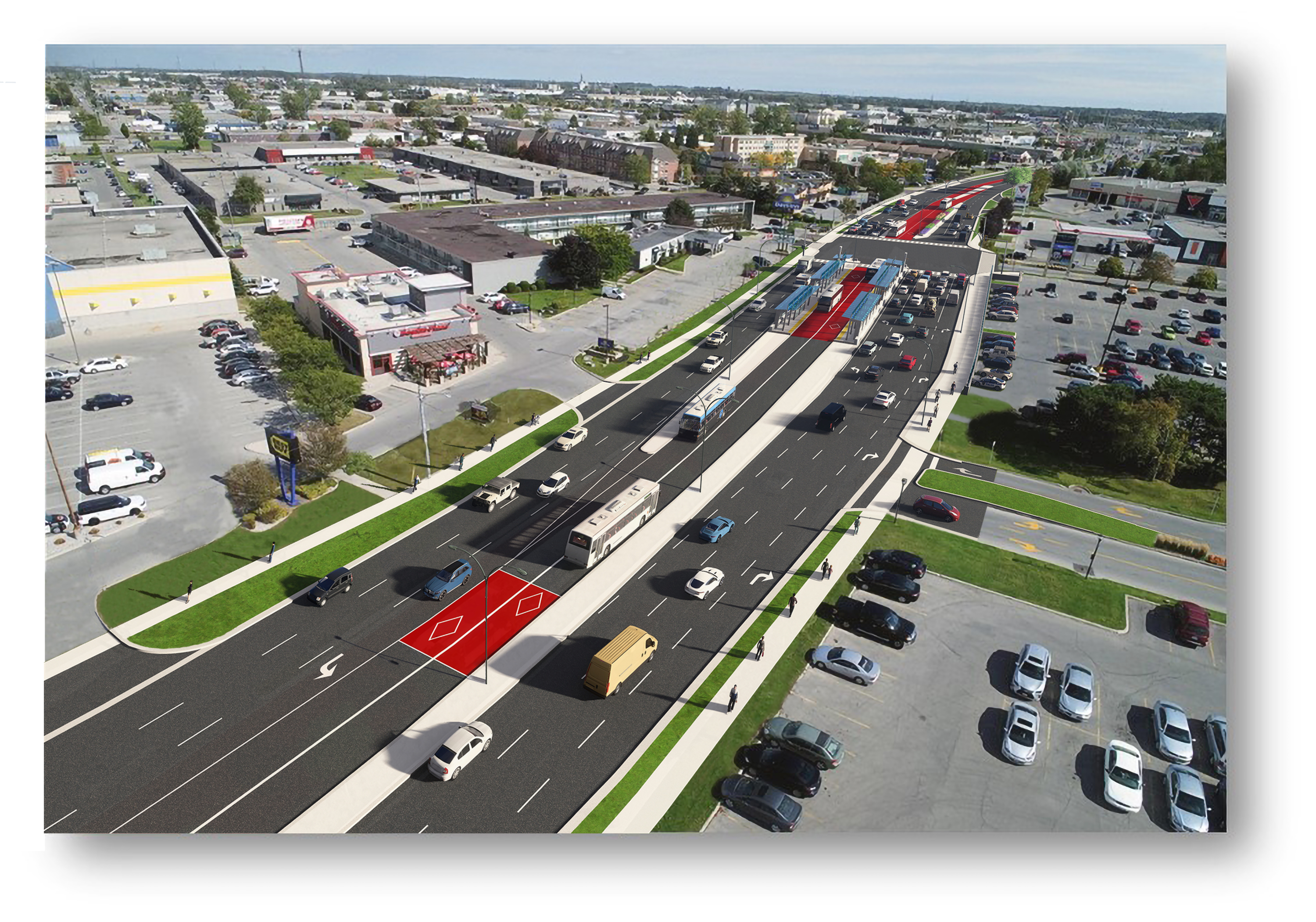
Concept rendering of Wellington Road with new BRT median lanes near White Oaks Mall
Entering and leaving downtown along Wellington Street, south BRT buses will still have to squeeze through an older four-lane railway underpass in mixed traffic, limiting bus throughput. The lack of a northern segment between Downtown, Western University, and Masonville Place Mall is another major downfall.
Bottlenecks, like Richmond Street North, will limit how fast and how attractive transit will be to prospective riders
Though it is hoped that London’s Rapid Transit project will help shape development — much in the same way Waterloo Region’s Ion LRT has — the cost-cutting will limit this potential. The Wellington Road BRT median might help improve bus reliability along a congested traffic corridor, but the lack of signal priority — plus the railway underpass bottleneck — will not help. Western University students will still have to endure a slow ride north from downtown, reducing the attractiveness of Wellington Street, currently littered with big-box stores and strip plazas, as a place to build up with private mixed-use development. Perhaps the eastern segment on King and Dundas Streets, serving the regenerating Old East Village neighbourhood, will be more successful.
Middlesex County Connect and “Local Motion” buses at St. Thomas, June 2024
On Saturday, June 15, I took a trip that was not possible for over a decade: I went to St. Thomas, Ontario, without a car. This was possible because of one of several new intercity transit links that opened this year in Ontario, and I have updated my interactive map accordingly.
Intercity Bus minibus on York Street at Royal York Hotel, February 13, 2024
In late 2023, yet another intercity bus operator started serving the busy Toronto-London corridor, operating between Toronto and London. With the rather unimaginative name of “Intercity Bus,” this new company operates up to four trips a day between Toronto and London. It has since added a route between London and Sarnia; it also plans to run the much-needed link between London and St. Thomas.
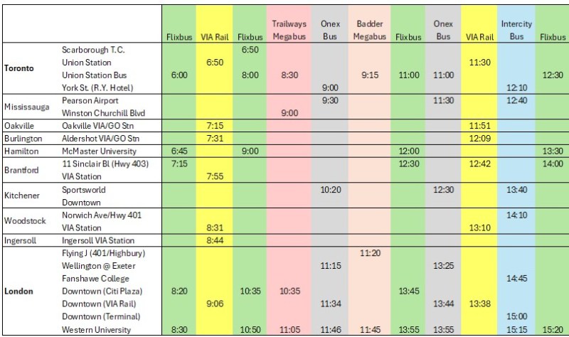
There are now five bus companies on the Toronto-London route: Intercity Bus, Onex Bus, Trailways, and Megabus (in a partnership with local coach operator Badder Bus). Those five companies compete with VIA Rail, which operates up to six daily trips between the two cities, with up to 28 round trips daily between them.
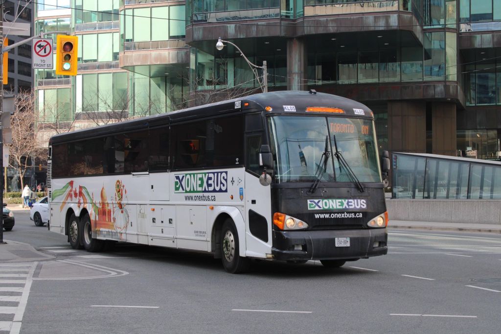
Onex Bus departing Downtown Toronto, photo kindly provided by Chris Whitfield
VIA Rail remains the fastest and most comfortable option, with full-service staffed stations in Downtown London and Downtown Toronto, but its fares are typically the most expensive. The private coach companies offer cheaper fares, and several of them directly serve Western University and/or Fanshawe College. Megabus has partnered with Trailways; its booking website includes both the Toronto-London-Detroit Trailways trips and the Toronto-London trips operated by Badder Bus. Otherwise, one must go to the individual companies’ websites to figure out the complete schedule and where each service stops at.
The schedule below, saved as a PDF, includes all regular weekday trips between Toronto and London along with intermediate stops.
In Toronto, Flixbus, Trailways and Megabus/Badder call at the Union Station Bus Terminal, where connections can be made to other Flixbus and Megabus services, along with GO Transit and VIA Rail in the adjacent railway hub. Onex and Intercity Bus make use of a curbside stop on York Street next to the Royal York Hotel, which is shared with the Toronto Island Airport shuttle. These three stops are all within a few minutes’ walk from each other. Some Flixbus runs to London begin and end in Scarborough, and many buses also make a stop at Pearson Airport.
In London, every bus carrier makes a curbside stop at Western University, the terminus of all bus trips from Toronto except Trailways, which continues to Windsor and Detroit. All carriers except Badder/Megabus also serve Downtown London. However, each has a different stopping location, with Flixbus and Trailways opting for a curbside stop on York Street near CitiPlaza (London’s downtown mall), and Onex utilizing the driveway at the VIA Rail station.
Curbside stops are convenient for bus operators, as they’re easy to pull up to and depart from, there’s no rent, staffing, or maintenance costs. With smartphones and online ticketing, there is no need for a ticket agent, and passengers can be notified by text and/or email of any delays or changes. But curbside stops have no shelter and no washrooms.
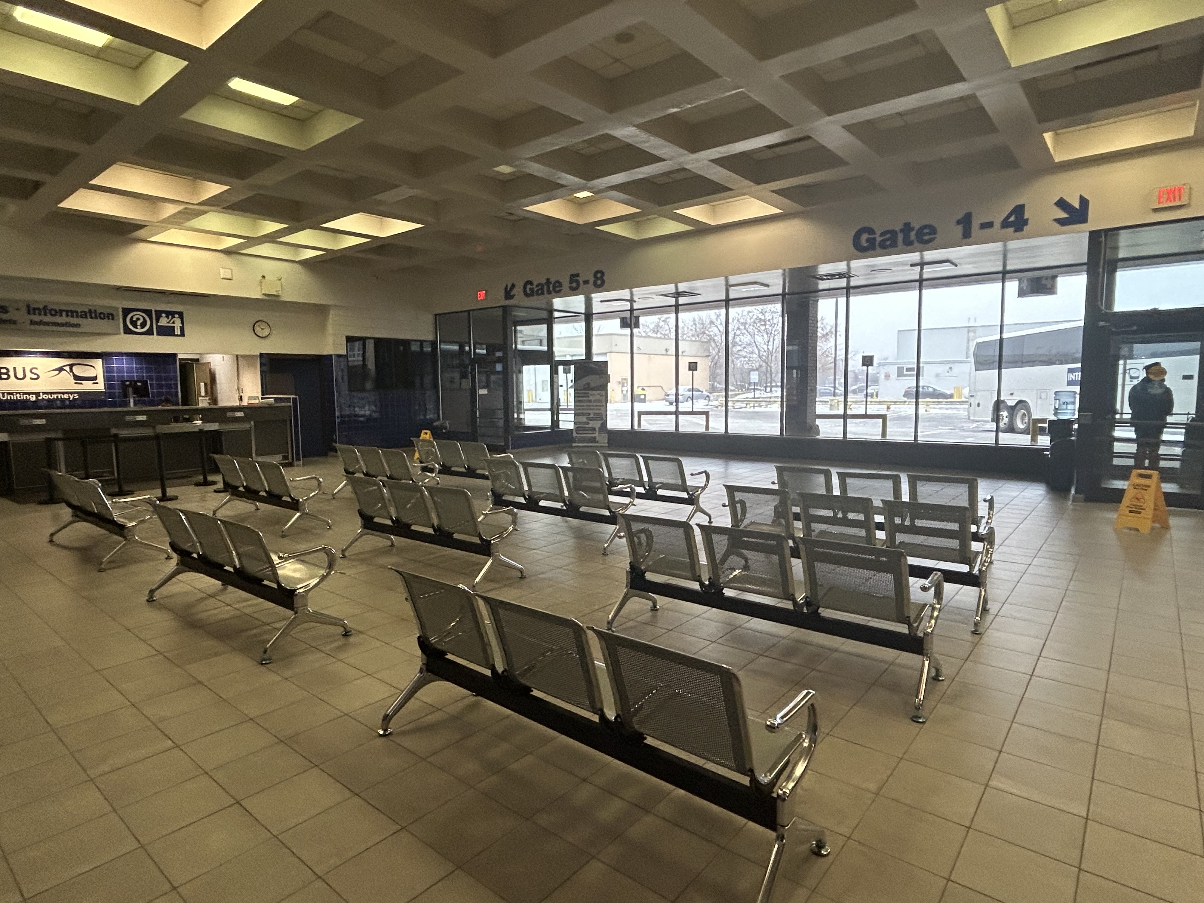
Interestingly, Intercity Bus has taken over the old Greyhound terminal in Downtown London. At its peak, London’s terminal had dozens of daily departures to cities and towns all over Southwestern Ontario, serving multiple carriers at a time when intercity carriers acted more like a unified network.
The old London Greyhound terminal
The terminal offers seating, washrooms, and is staffed by an agent, a rarity in the post-Greyhound world. The washrooms are especially essential if — as on my recent trip — the bus does not have an on-board lavatory. These new smaller carriers save fuel and labour costs by operating smaller vehicles and matching capacity with demand. They often operate older coaches and minibuses.
Inside the Intercity Bus terminal
I recently took Intercity Bus from Toronto to London to try out Ontario’s newest carrier. Though the 12:10 departure from Toronto was on a minibus similar to those used by rural transit operators (there were only 10 passengers on that Tuesday afternoon run), the ride was comfortable enough, with cloth bucket seats. It was a fast trip: it skipped stops in Woodstock and Fanshawe College, and the driver made very good time on Highway 401, at times exceeding the posted speed limit by 25 or 30 kilometres per hour. Even with a stop for fuel (the driver asked if it was okay), we arrived 15 minutes early at the London terminal.
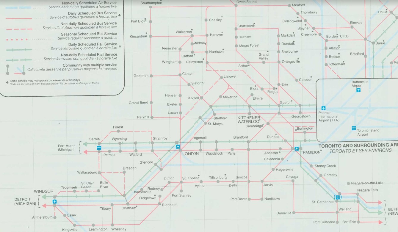
At its peak in the 1980s, there were over two dozen daily departures from the London bus terminal. There were frequent Greyhound routes to Toronto via Kitchener and via Brantford and Hamilton as well as to Chatham, Windsor, and Detroit; there were also daily Greyhound routes to Niagara Falls via St. Thomas, Simcoe, and Welland and to Strathroy, Sarnia and into Michigan. Regional coach operators also ran from the Greyhound terminal to Stratford, Goderich, Rodney, Walkerton, Leamington, and Port Stanley. Today, there are just four — three to Toronto and one to Sarnia.
Detail from 1990-1991 Ontario Intercity Transportation Guide, showing bus routes from London to points throughout Southwestern Ontario
My hope for the next year is for more stability in the intercity bus industry, perhaps even mergers between some of the smaller players. Onex and Intercity Bus, which compete on the Toronto-London route and offer a similar service, could be beneficial, especially if it results in a network of routes radiating out of London, starting with Intercity Bus’s London-Sarnia service, its planned St. Thomas route, and Onex’s London-Stratford-Kitchener run.
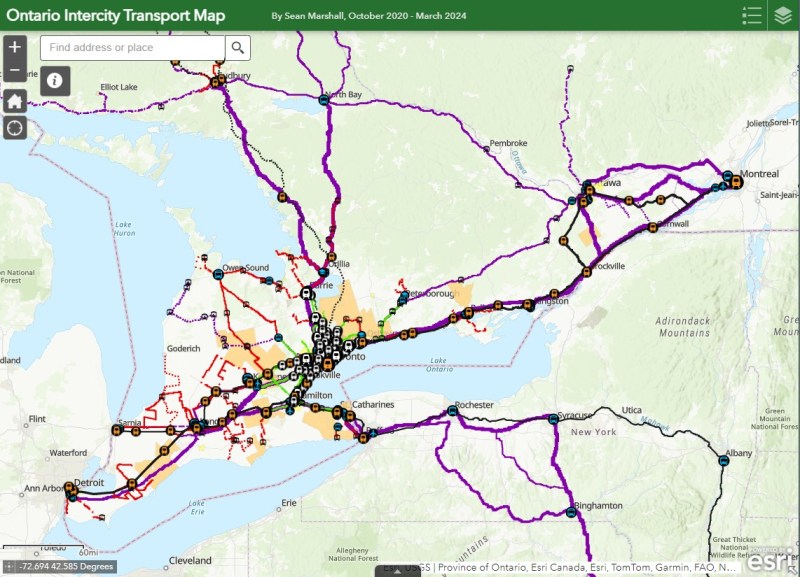
I updated my map of Ontario’s intercity transport services for March 2024, including the new Onex Bus and Intercity Bus routes in Southwestern Ontario. There are new services in East Zorra-Tavistock, connecting to Stratford and Woodstock, and in North Grenville. Unfortunately, Lindsay and Haliburton lost their TOK coach service, Prescott & Russell ended its on-demand service, and gaps remain in Bruce, Elgin, and Haldimand Counties.
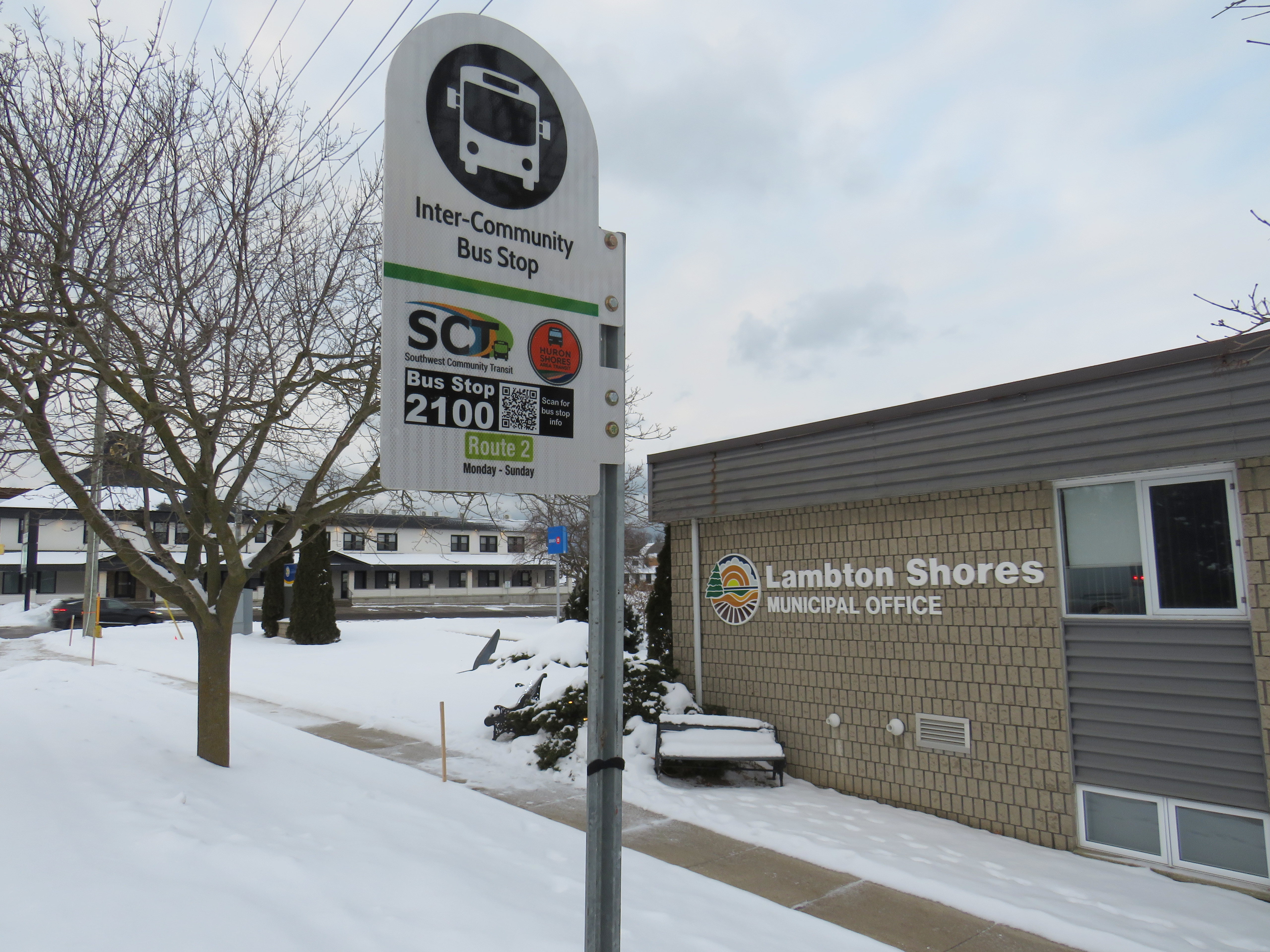
In January 2023, while visiting the site of the now-demolished Sarnia Eaton Centre, I took advantage of two new rural transit services serving Southwestern Ontario: Strathroy-Caradoc Transit and Huron Shores Area Transit. While both services connect London and Sarnia, they operate as separate services with different fares; they also have different terminals.
Strathroy-Caradoc Inter-Community Transit bus at Lambton Mall in Sarnia
Strathroy-Caradoc Transit offers the most direct service between London and Sarnia, with stops at London International Airport, Downtown London (on York Street near the VIA Station), Komoka, Mount Brydges, Strathroy, Lambton Mall, and Downtown Sarnia.
The regular cash fare between London and Sarnia is $20, though from London or Sarnia to Strathroy, the fare is $10. On my westbound trip on Sunday, January 29, the schedule allowed for a quick washroom and coffee break in Downtown Strathroy, a necessity given the long ride on a small minibus.
Returning the next day from Sarnia, I opted to ride Huron Shores Area Transit (HSAT) back to London. HSAT, which is also contracted to Voyago, connects several communities in Lambton, Huron, and Middlesex Counties. All four HSAT routes converge in the summer resort town of Grand Bend. Two routes operate seven days a week (Route 1, connecting Sarnia, Forest, Thedford, and Kettle Point & Stoney Point First Nation, and Route 2, serving Exeter, Lucan, Centralia, and London). There are two additional routes operating two days a week from Grand Bend to Goderich and to Parkhill and Strathroy.
Unlike Strathroy-Caradoc, HSAT operates on a flat $5 cash fare. Even though I was traveling the long way between Sarnia and London, with an hour-long layover in Grand Bend, I was offered a slip of paper marked by the driver that allowed me to board the second bus without a second fare. Huron Shores buses have bike racks, though the operator recommends calling ahead to ensure their availability.
While Strathroy-Caradoc Transit serves downtown London and Sarnia, HSAT’s buses go only as far as the first major destination in both cities. The Sarnia stops for Route 1 are at Lambton College and nearby Lambton Mall, while the London stops on Route 2 are on London’s north end, near Masonville Place and at the University Hospital on the Western University campus. Getting downtown requires a transfer to Sarnia or London Transit.
Huron Shores Area Transit bus at London’s University Hospital. Note the bike rack.
Though VIA Rail still operates one daily train between Toronto, London, and Sarnia, it is not on a convenient schedule for most passengers (it leaves Sarnia early in the morning and arrives late in the evening), so the new bus services fill a key role in providing mobility options. Though it is more expensive, the Strathroy-Caradoc route is the direct and the fastest connection. But Huron Shores trip is the more scenic and cheaper ride.
I updated my Ontario intercity transportation map for April 2023 to include the major GO Transit service changes, the gradual resumption of some Ottawa commuter bus routes, the start of Travelways bus service between Detroit, London, and Toronto, and minor route and service changes elsewhere in the province.
The hour-long layover in Grand Bend gave me a chance to wander the town. On the main street, almost every business was closed for the season. There was very little traffic on Main Street, so it had a bit of a ghost town feel. On Highway 21 and to the east, however, typical chain stores like Tim Hortons, Sobey’s, and Shoppers Drug Mart serve the year-round population.
Grand Bend’s famous beach — in JanuaryHello Sunshine
On Friday, May 13, I embarked on a day trip through Southwestern Ontario from Downtown Toronto. I wanted to ride more of Ontario’s new intercommunity transit services and try one of the new intercity bus operators that’s filling the vacuum left by Greyhound’s departure. I started my trip at Union Station, spent some time in Kitchener-Waterloo, then continued on to London, returning home that evening.
Between Toronto and Kitchener, there are several options. VIA Rail is the fastest and most comfortable ride, but it now only operates one train a day between Toronto and Kitchener.
GO Transit is the most frequent option, with several weekday trains between Toronto, Brampton, Guelph, and Kitchener, and connecting buses at Bramalea GO Station for Downtown Kitchener and Waterloo. The train and bus trip via Bramalea is just under 2 hours, costing $19.40. (Weekend GO service is much slower, requiring a change of bus at Square One, with a 2 hour, 33 minute ride.)
The traveler might also choose one of the new private carriers. FlixBus has one daily departure at 7:45 AM from Downtown Toronto (on York Street, south of Union Station), with a second 2:15 PM trip departing Thursdays through Sundays. Though FlixBus is the cheapest option — only $14.24 with tax — it is slightly slower than GO Transit’s direct train or its Bramalea bus connection, as it deals with Downtown Toronto traffic and serves Guelph on its way to Kitchener. Onex Bus also stops at Kitchener on its Toronto-London route, but it stops at the Sportsworld Terminal near Highway 401, requiring a change to Grand River Transit’s buses.
Because of the flexibility and convenience, I choose GO Transit, switching from train to bus at Bramalea. Because of continuing construction at Bramalea Station, I had trouble finding the bus stop for the Route 30 to Kitchener and University of Waterloo, but once work is complete on the bus loop, the transfer between modes will be quite easy.
Route 30 is a fast bus route, stopping only at the Meadowvale Business Park in Mississauga, where connections can be made to several other GO Transit bus routes as well as Miway and Brampton Transit. In Kitchener-Waterloo, the GO bus stops at Downtown Kitchener, at Wilfrid Laurier University, and at a new terminal at University of Waterloo. This is in contrast to Route 25 between Square One and University of Waterloo, which exits the highway multiple times to make local stops, and is the only weekend GO service.
The new bus terminal at University of Waterloo, serving local GRT routes, GO Transit, and the ION LRT.
Between Kitchener and London, however, options are much more limited. Though the GO Transit Kitchener Line was recently extended to London, this is limited to one weekday train leaving London at 5:30 AM and returning to London at 8:37 PM. There is just one VIA train between the two cities as well. Onex Bus offers up to five trips daily between Sportsworld and Downtown London.
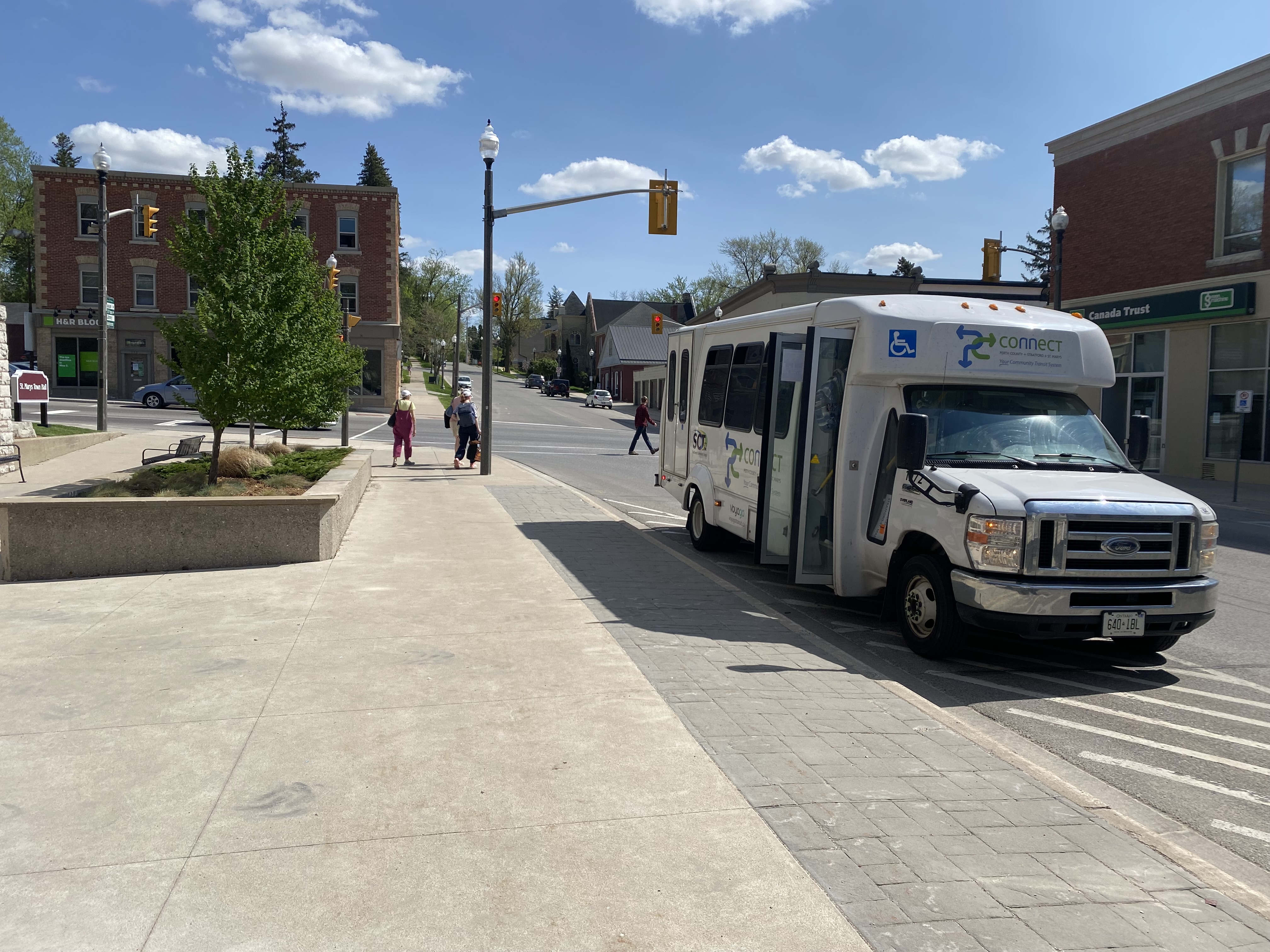
The other option is PC Connect, a provincially-funded intercommunity service connecting Stratford and St. Marys with Kitchener-Waterloo and London, as well as towns within Perth County with each other. From Conestoga Mall in Waterloo, I took the 2:50 PC Connect trip to Stratford and St. Marys. At St. Marys, I changed to a connecting bus for Masonville Place Mall in London. Each ride cost $12 cash. Service was friendly and on-time.
PC Connect Bus in St. Marys
At London, PC Connect stops on Fanshawe Park Road, adjacent to Masonville Place Mall, but a ten-minute walk from the main LTC bus terminal where connections can be made to Western University and Downtown London. (Huron Shores Area Transit, with service to Exeter and Grand Bend, stops on the north side of Fanshawe Park Road).
With VIA Rail’s service reduced between Windsor, London, and Toronto, the only trip back to Toronto after 5PM (on a Friday, a traditionally busy travel day) was an Onex Bus departure from the downtown VIA Rail station’s parking lot at 9:15 PM to Pearson Airport (the last trip of the evening continues to Bramalea City Centre, rather than Downtown Toronto). The VIA station at least is still open at that hour, with washrooms and an indoor waiting area.
I expected a coach bus, but instead, the 13 people waiting were greeted with a 15-seater van. Though the seats were relatively comfortable given the size of the van, passengers had to sit in tight spaces and there was no on-board lavatory like those on Greyhound or Coach Canada coaches. The one-way fare was $38.
The 15-seat van from London to Pearson Airport
Though the van arrived late in London (helpfully, a text was sent out to passengers), the trip to Pearson was uneventful, though it arrived about 30 minutes later than scheduled. I still had an hour’s TTC ride home to look forward to, instead of a 20 minute walk from Union Station or the old Toronto Coach Terminal.
As a private company operating in the newly deregulated intercity coach market, it made sense for OnexBus to utilize a smaller vehicle to minimize costs (the requirement for online advance booking makes this easier). But it was not up to the standards of legacy carriers such as Ontario Northland or Greyhound.
As more Ontarians travel and as post-secondary institutions return to full on-site learning in September 2022, it will be interesting to see how intercity transit providers and customers adapt to the new normal. I certainly would look forward to taking the train again once VIA returns to its full schedule.
Following Greyhound Canada’s inevitable final departure, several other companies have begun to take over Greyhound’s busiest routes in Ontario and Quebec.
In May, Megabus Canada began service between Toronto, Kingston, and Ottawa, operating out of the new Union Station Bus Terminal. Megabus’ terminal in Ottawa is the St. Laurent Shopping Centre, with easy connections to Ottawa’s O-Train LRT and several bus routes.
In June, Rider Express, a new intercity carrier based out of Western Canada (where it picked up many of Greyhound’s abandoned routes there), began operating its own Toronto-Kingston-Ottawa route, in competition with Megabus.
Québec-based Orleans Express took over Greyhound’s former Ottawa-Montréal route, joining Ontario Northland and Rider Express at the Ottawa VIA Station. The VIA Station, like St. Laurent, offers a safe, enclosed waiting area, passenger amenities, and easy connections to the O-Train LRT.
While Ottawa has many options for getting to and from Toronto: VIA Rail, Megabus, Rider Express, and two frequent airlines, connections to other cities and towns are limited at best. Ontario Northland’s single daily bus from Sudbury and North Bay through Renfrew County arrives in Ottawa in the late evening, a time not convenient for most passengers. Commuter routes to nearby communities such as Perth, Carleton Place, and Cornwall remain suspended during the ongoing pandemic.
But at least there’s some bus service again, providing new capacity on some of Canada’s busiest intercity routes.
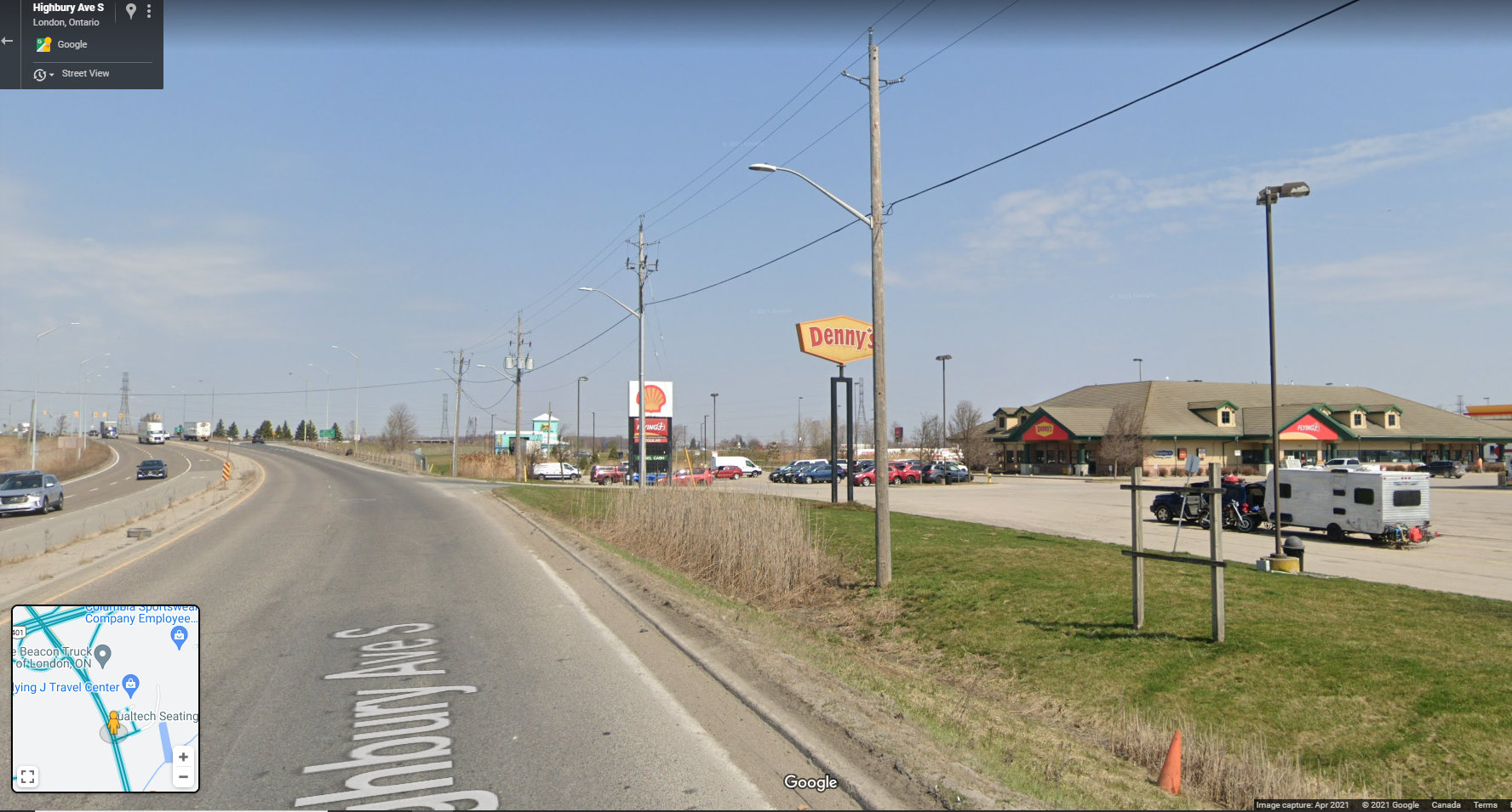
On Thursday, July 15, intercity coach service returns to Southwestern Ontario, with a new Toronto-London service operated through a partnership between Megabus and St. Thomas-based Badder Bus. The route will run non-stop twice daily between the Flying J Truck Stop at Highway 401 and Highbury Avenue and the Union Station Bus Terminal in Downtown Toronto.
Unfortunately, the Flying J truck stop, while convenient for truckers and other motorists, is a terrible place for a bus stop. The map below illustrates the truck stop’s location, on the southeastern outskirts of London.
The truck stop was likely chosen for its proximity to Badder Bus’ operations centre in nearby St. Thomas, and for the space available to park and load a bus in the RV/trailer parking area. The truck stop operates 24 hours, with an on-site convenience store, washrooms, and restaurant, so there are amenities for bus drivers and waiting passengers.
Unfortunately, Megabus and Badder Bus could not pick a less accessible place to catch a bus. The truck stop is surrounded by warehouses, light industry, and agricultural lands. Highbury Avenue is a high-speed highway connecting Highway 401 and central London, with a 100 km/h speed limit. Pedestrians and cyclists are prohibited from using Highbury Avenue (which, until the 1990s, was provincial Highway 126). There are no sidewalks leading south to Wilton Grove Road.
Looking north on Highbury Avenue towards Highway 401, with the Flying J truck stop on the right. Note no sidewalks — pedestrians and cyclists are prohibited from Highbury Avenue at and north of the 401. (Google Streetview – April 2021)
The only transit route within walking distance is London Transit Route 30, a rush-hour only service that serves the industrial area south of Highway 401. Downtown London is easily a 45 minute bus ride (when route 30 is operating), and Western University — a major market for Greyhound when it operated — is over an hour away by bus or a $50 taxi ride. Ironically, the northern outskirts of St. Thomas — that city remains disconnected to nearby London — are closer to the Flying J than Western University.
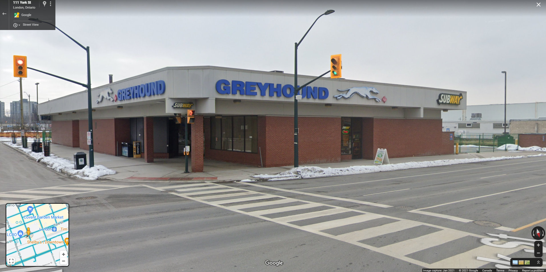
The Greyhound Terminal in downtown London, two blocks from the VIA Station. At its peak in the 1980s, the terminal served Greyhound, Gray Coach, Erie Coach, and Cha-Co Coach, with buses departing for Toronto, Detroit, Niagara Falls, Buffalo, and cities and towns throughout Southwestern Ontario. (Google Streetview – January 2021)
Greyhound Canada operated out of a terminal in Downtown London, two blocks west of the VIA Rail station. Greyhound shared its building with other carriers in the 1970s, 1980s, and 1990s, including Gray Coach, Cha-Co Trails, and Erie Coach Lines. From Downtown London, there were direct buses to Toronto, Detroit, Niagara and Buffalo, and cities and towns throughout Western Ontario. The terminal was a short walk to nearly all of London Transit’s bus routes, making connections to Western University, Fanshawe College, and the major hospitals easy.
Choosing a truck stop at the far edge of town, nearly inaccessible by public transit reminds me of the final years of Greyhound’s operations in Western Canada. Greyhound abandoned downtown terminals in Winnipeg, Edmonton, Regina, and Saskatoon in favour of new stops in outlying area.
In Edmonton, the downtown Greyhound terminal was expropriated for a new hockey arena, but Greyhound moved for the VIA station in the city’s northwest, which had no public transit access. (Red Arrow, a competing coach operator, maintained a downtown office and stop). In Regina, Greyhound moved from the downtown STC terminal to the airport, which has no public transit connection, and in Saskatoon, Greyhound moved to a truck stop — similar to London’s Flying J — in the northern outskirts of that city. It was clear that Greyhound Canada had no interest in attracting customers and was planning for an eventual withdrawal.
Given Greyhound’s experience, why would a new carrier choose such a poor location for an intercity bus stop, especially in a city as large and important as London? The terminal need not even be in Downtown London to be a major improvement; a stop at White Oaks Mall, just one interchange to the west at Wellington Street, would provide good local transit connections to Downtown London and even Western University while remaining close to the highway.
For now, Ontario’s newest bus stop might also be its worst bus stop.
In June 2020, Toronto-based artist and activist Andrew Lochhead launched a petition to rename Dundas Street, one of Toronto’s oldest, longest and best-known arterial roads. Lochhead states that Henry Dundas, 1st Viscount Melville “actively participated in obstructing the abolition of slavery in the British Empire from 1791 to the end of his political career in 1806.” While some historians may argue that Dundas was a pragmatic moderate, rather than an anti-abolitionist (unlike slave-owning Torontonians like William Jarvis or Peter Russell, who have streets named after them), it’s still worth wondering why Toronto has a street named after the Scottish politician, who had nothing to do with Toronto’s colonial history.
Until recently, I gave Dundas Street little thought. Years ago, I wrote about how the street was pieced together in the late 19th and early 20th century to provide a new through east-west route across central Toronto. Though I was aware that Dundas Street began at the present-day corner of Queen Street West and Ossington Avenue, I had long thought the road was named for the town of Dundas, to which it leads.
The end of Desjardins Canal, in the old Town of Dundas
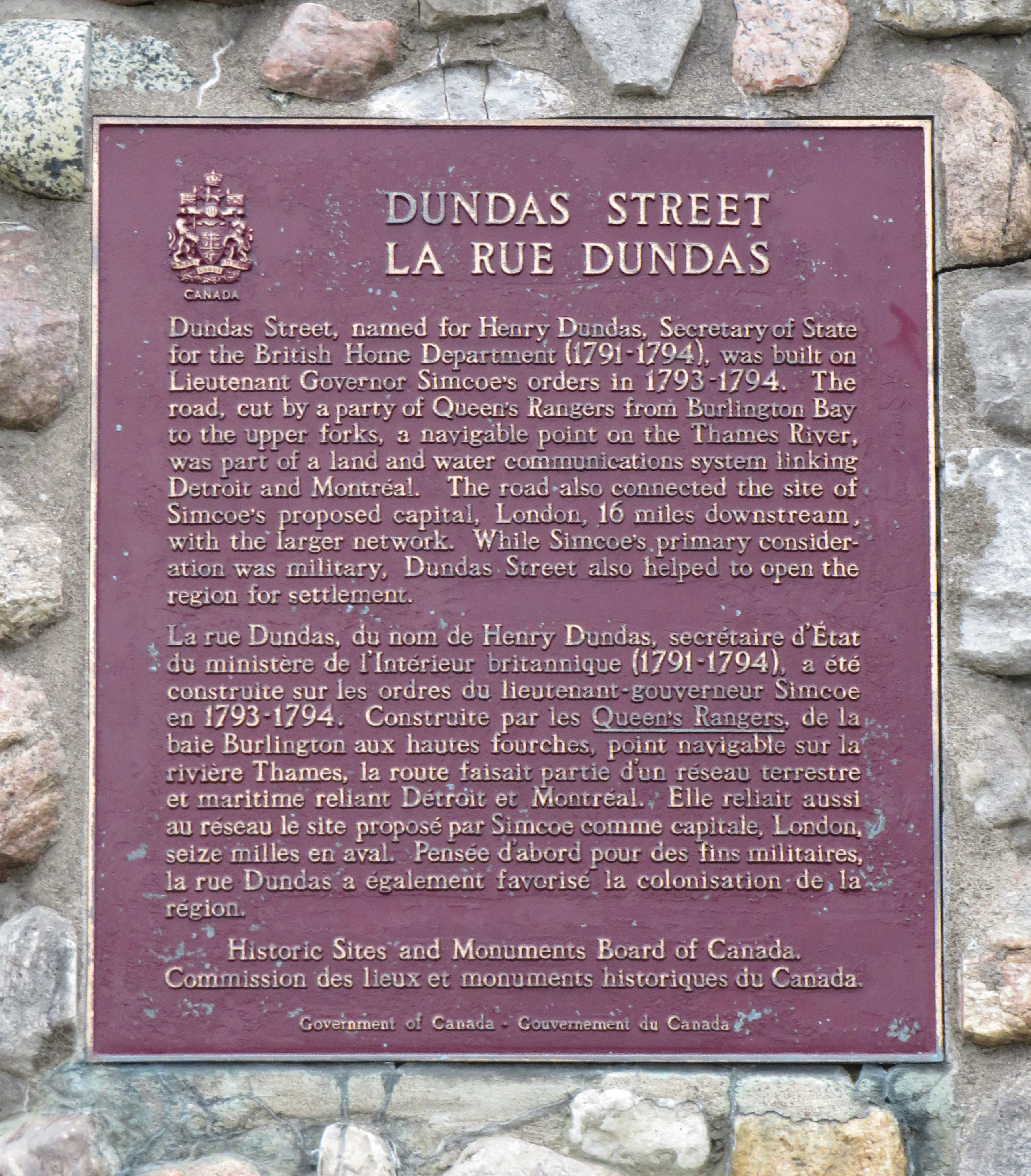
Dundas Street was established as a military supply route by order of John Graves Simcoe, the first British governor of Upper Canada. At first, it was surveyed and cleared in 1794 and 1795 between Cootes Paradise (at the very end of Lake Ontario, beyond Burlington Bay) and the Upper Forks of the Thames River, at what is now Woodstock. From there, small boats could be used to travel downriver to London and to Lake St. Clair. Though there were several Indigenous trails connecting Lake Ontario and the Thames River (the western part of Mohawk Road in Hamilton follows one such route), the new British colonial government favoured a straight, direct road.
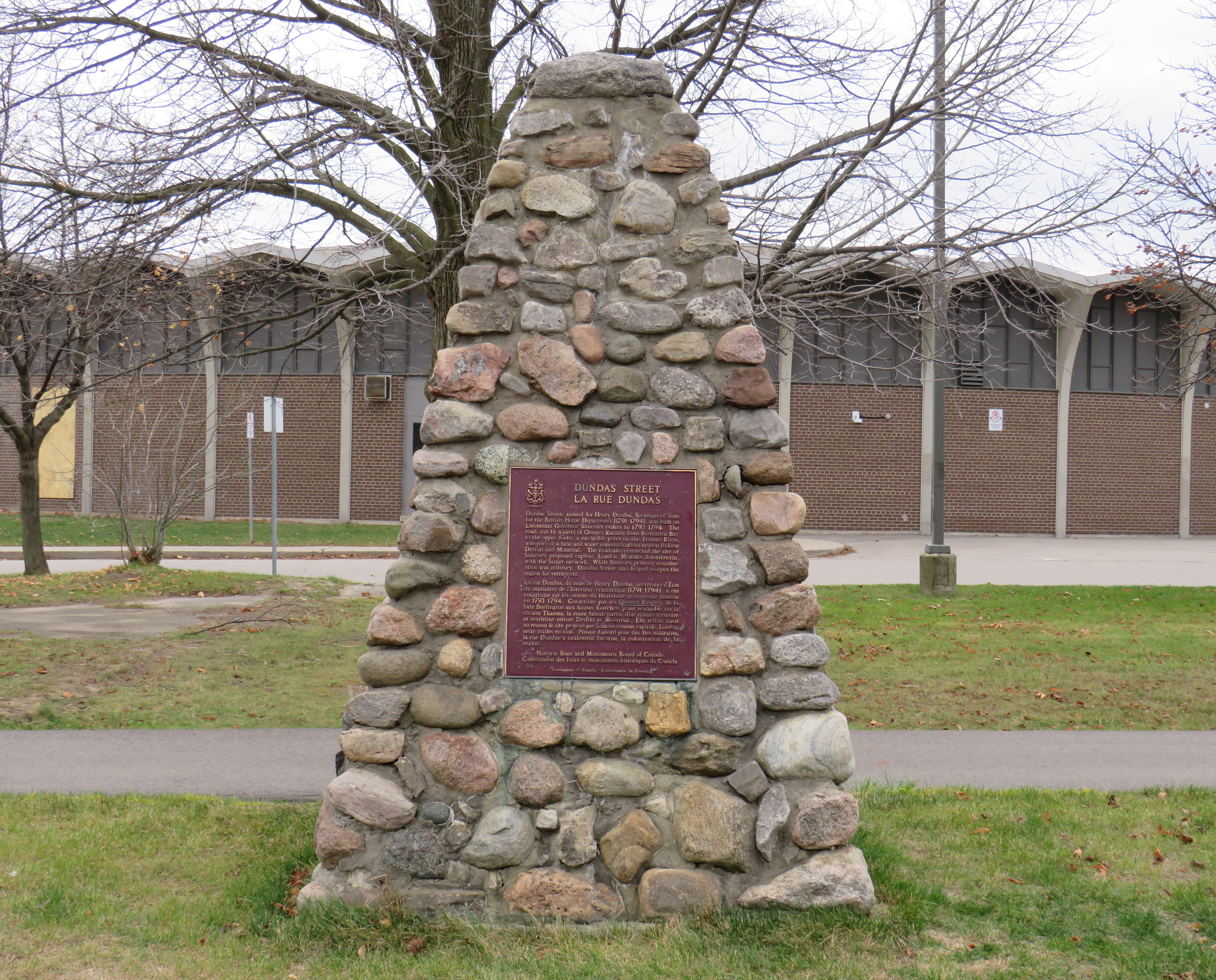
A federal plaque on a cairn in front of Dundas Valley Secondary School in Dundas
Though Dundas Street (which is known as Governor’s Road between Dundas and Paris) features a gentle climb up the Niagara Escarpment, detours were quickly established to get around challenging terrain, such as the confluence of Grand and Nith rivers near Paris. Dundas Street was soon extended westward, to Simcoe’s preferred capital site at London, and extended eastward, to York (Toronto).
Yonge Street, which was originally surveyed and cleared between Lake Ontario and the Holland River near Lake Simcoe, served a similar purpose as Dundas Street. Combined with Penetanguishine Road, Yonge Street provided a military supply route to Lake Huron, though bypassing the established Toronto Carrying Place trail. Though Dundas and Yonge Streets were built with military goals in mind, they, like many other early colonization roads, helped to promote new settlement of lands claimed from local First Nations. Like Dundas Street, Yonge Street was named for a senior British official — George Yonge, who was the British Secretary of War in 1793.
In its early years, Dundas Street’s position inland from Lake Ontario was advantageous as it provided an alternate route in case of invasion. The winding route through Etobicoke and West Toronto to Ossington Avenue allowed travellers to avoid deep ravines and Grenadier Pond.
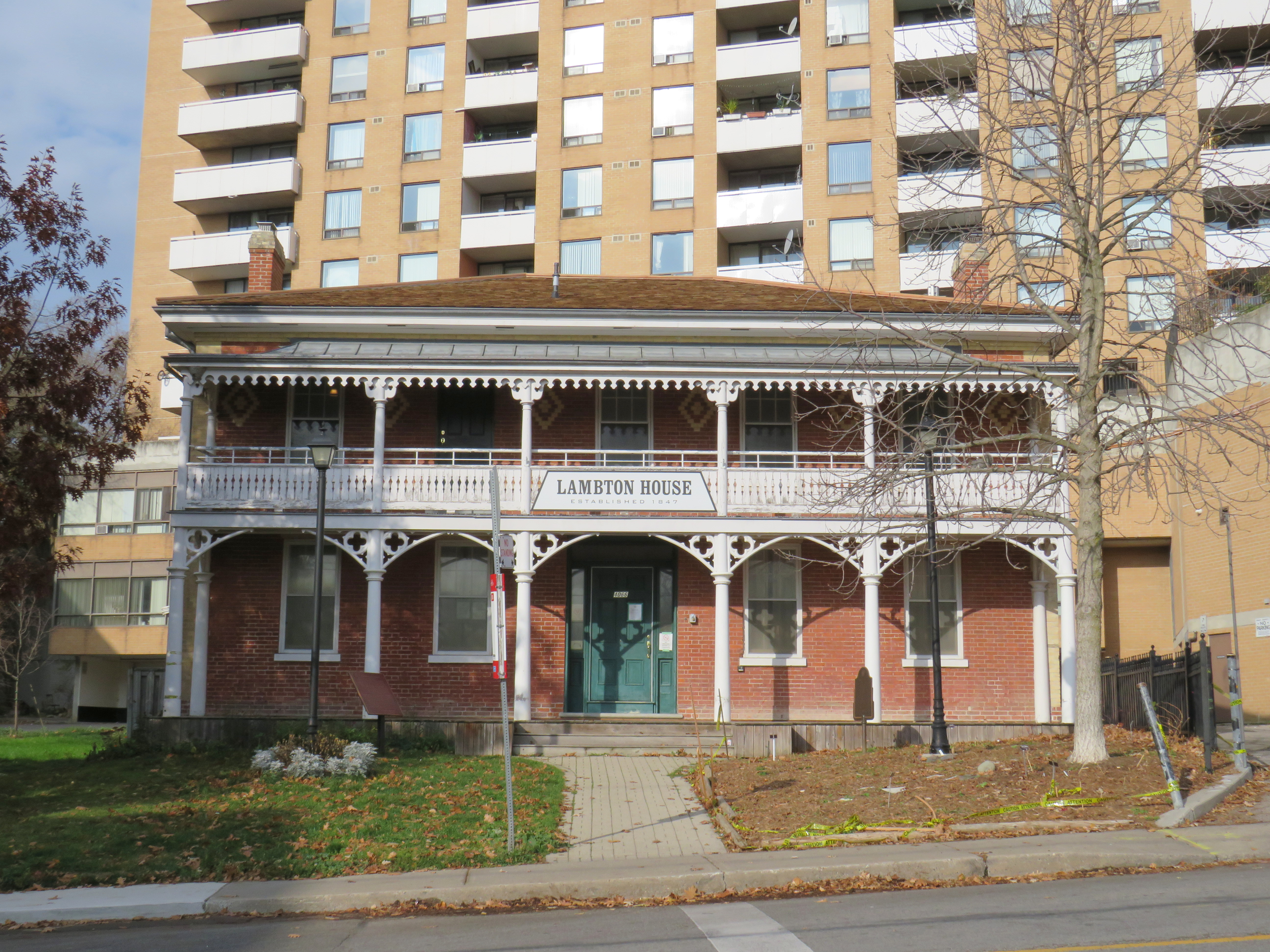
Lambton House, Old Dundas Street
Other early settlement routes, such as Weston Road, branched off of Dundas Street, leading to newly settled lands to the north and northwest of Toronto. Taverns dotted the route, providing accommodation and libation to travelers, several of which — including Lambton House and Montgomery’s Inn — survive to this day.
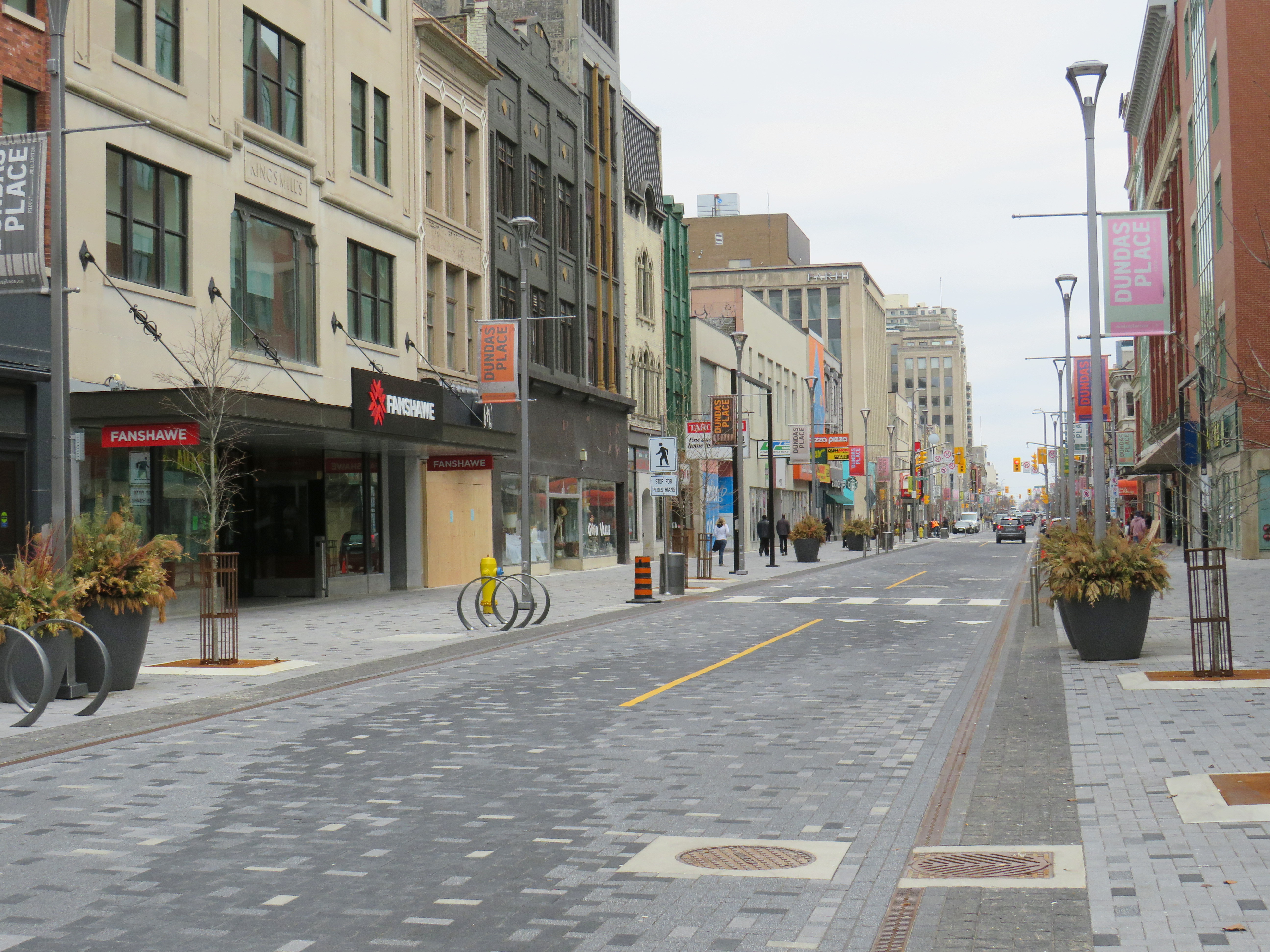
In London and Woodstock, Dundas Street formed the basis for each city’s downtown core. In London, it was recently rebuilt as a two-lane flexible street called Dundas Place, intended to host public events and revitalize the street, which has seen a loss of business to suburban malls and big box stores and to trendier bars and restaurants on Richmond Street, closer to Western University.
Dundas Street in Downtown London was recently rebuilt as a flexible street
Outside the cities, though, other routes surpassed Dundas Street in importance by the mid 1800s. The Lakeshore Road soon became the preferred route between Toronto and Hamilton (which overtook the town of Dundas in size and importance), while the railways, established between Toronto, Hamilton, and London in the 1850s, further eroded Dundas Street’s importance as a major through route until the automobile gained in popularity.
Much of the road between Paris and London became part of interprovincial Highway 2, which extended across Eastern Canada from Windsor, Ontario to Halifax, Nova Scotia. The Waterdown-Etobicoke section became part of Highway 5, while the lesser-travelled section between Paris and Dundas (which today is known as Governor’s Road) was established first as Highway 5B in 1938, then as Highway 99 in 1940.
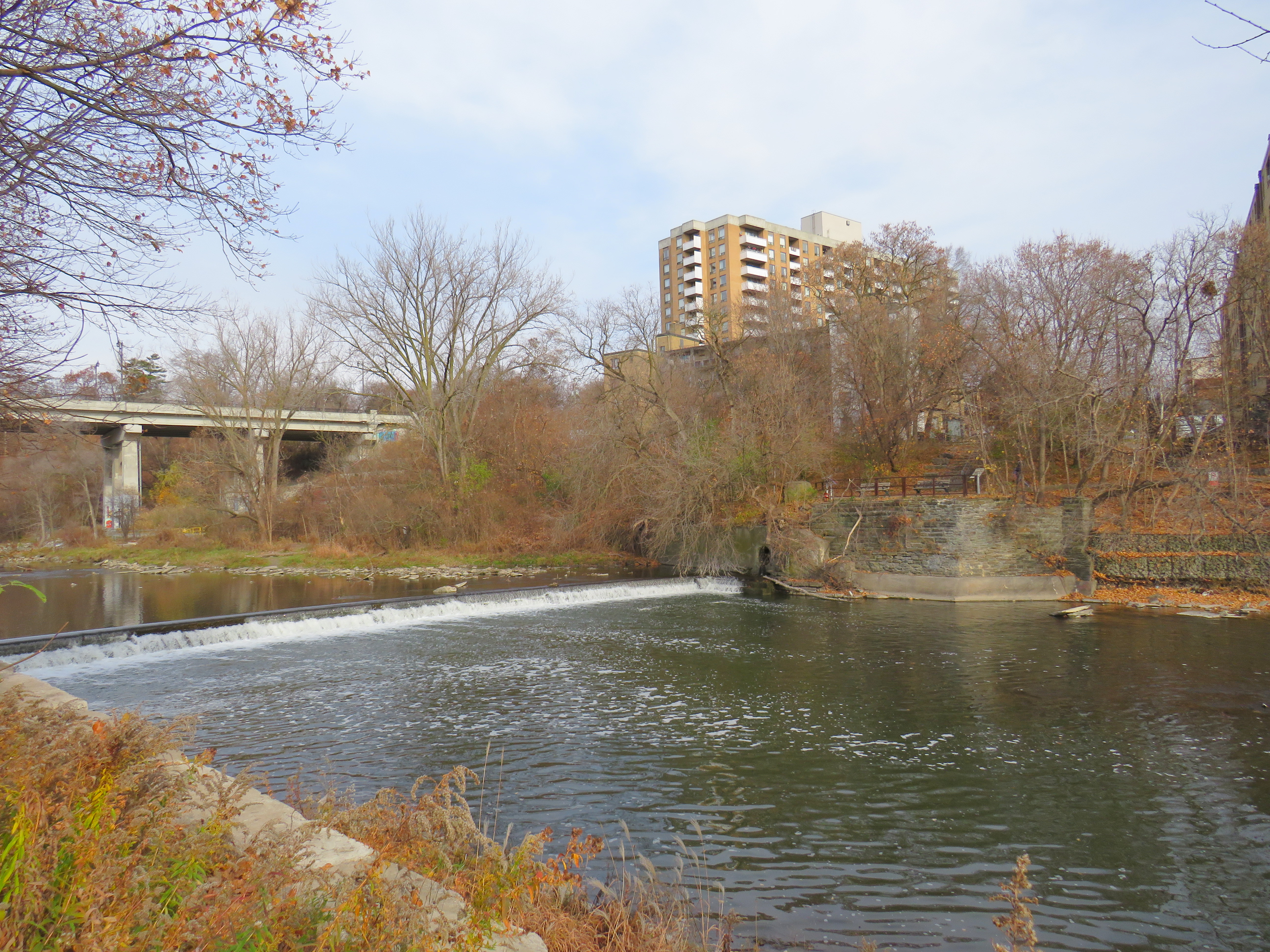
The remains of the old Dundas Street bridge over the Humber, removed in 1928, looking west to the former settlement of Lambton Mills. The replacement high level bridge is seen to the left. The approaches to the old bridge are named Old Dundas Street.
The Dundas-Waterdown section, which winded its way up the escarpment (only to descend it again a short distance east), became a minor road, with part of the original alignment abandoned by the 1850s.
Though it never held the status of Toronto’s main street, Dundas Street would gain in importance and length in the 19th and early 20th centuries. As Toronto grew beyond its early street grid, it came up against the park lot system devised by Governor Simcoe and other officials to establish a landed gentry in the new colony (including the slaveholding Jarvis and Russell families, who worked to prevent Simcoe from instituting a complete abolition in Upper Canada). These lots which were long and narrow, extended north from Lot (now Queen) Street, and each were developed independently. This resulted in a mess of east-west streets that did not necessarily meet each other. Though College Street was laid out with minimal difficulty, there was no continuous east-west street between College and Queen Streets east of Ossington Avenue.
Dundas Street West, looking southeast from Dovercourt Avenue towards the downtown skyline. This is part of the 220-year old western extension of Dundas Street from the head of lake to York (Toronto).
But by the early 1910s, Dundas Street was extended eastward, at first to Bathurst Street, following Arthur Street — which was widened to permit Toronto Railway Company streetcars — and then east to Yonge via St. Patrick, Anderson, and Agnes Streets. Jogs between these streets were slowly realigned, starting with the St. Patrick-Anderson-Agnes jogs between McCaul Street and University Avenue. However, it wasn’t until 1953 that the jog between former Arthur and St. Patrick Streets at Bathurst Street was eliminated. Scadding Court Community Centre now sits on the old roadway, though a small part survives as the centre’s staff parking lot.
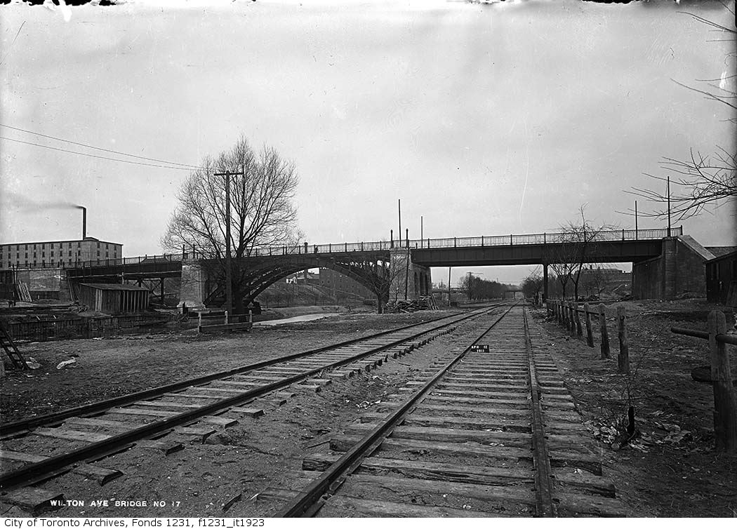
East of Yonge Street, Wilton Avenue was extended across the Don River in 1911, extending just east of Broadview Avenue, incorporating Elliot and Crawford Streets. Though the new bridge was built with streetcar tracks and overhead poles, through service did not begin until 1923, as part of a major TTC route restructuring.
By 1920, Wilton Avenue was renamed Dundas Street East, though the through connection across Yonge Street was not completed until 1922, with the block long section east of Yonge left over from the realignment renamed Dundas Square.
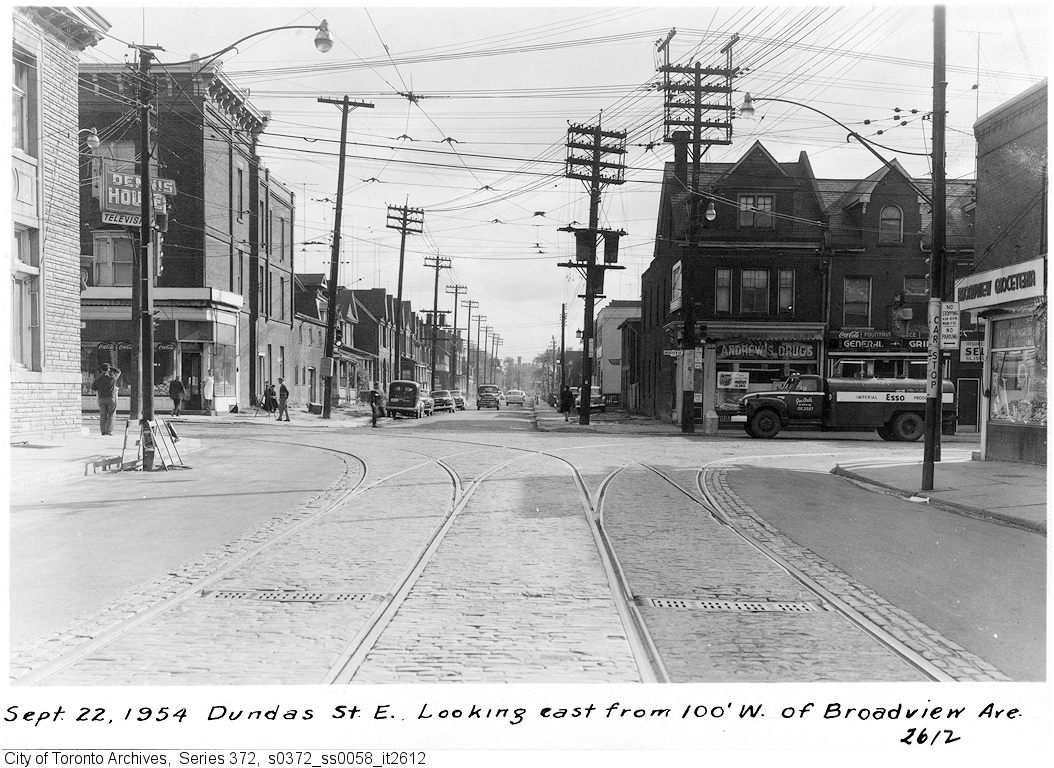
Though the early extensions of Dundas Street through the city simplified the street grid and allowed for through streetcar service between West Toronto and Broadview Avenue, the eastern extension built in the 1950s was done entirely for the benefit of the automobile.
Though Dundas Street extended east of Broadview for one block to Boulton Avenue, it was as a narrow residential street, and did not continue beyond (this is why the Harbord Streetcar took a convoluted route via Dundas, Broadview, and Gerrard to get to Carlaw and Pape Avenues). New roadways were planned to expand traffic access to Downtown Toronto from the burgeoning suburbs, including a new extension of Dundas Street east to Kingston Road.
From Boulton Avenue, a new alignment was built east to Pape Avenue, resulting in the demolition of over a dozen houses on Boulton Avenue, De Grassi Street, West Avenue, and Wardell Street, before ducking under the Canadian National mainline in a new underpass built in 1953, and through an industrial area, avoiding major factory buildings.
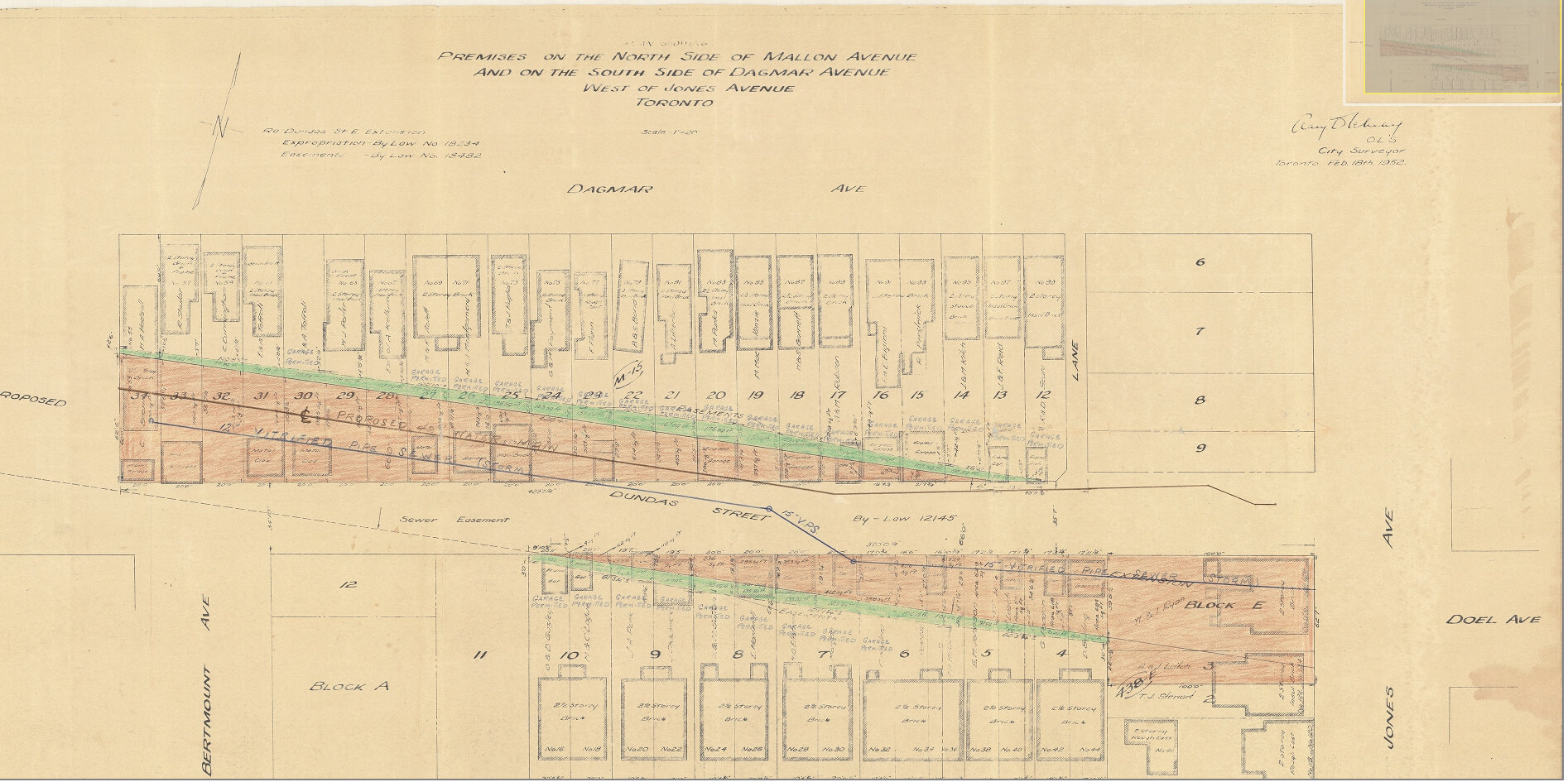
East of Pape Avenue, the new roadway followed a widened Dagmar Avenue, before bending south though a former alley to Jones Avenue to connect with former Doel Avenue to Alton Avenue. Between Alton and Woodfield Road, another new section of roadway was built, through an old brickyard in the late 1940s, connecting with Applegrove Avenue to Coxwell Avenue. The final section, between Coxwell Avenue and Kingston Road, was built through a minor ravine, connecting with, and replacing part of, Maughan Crescent and Edgewood Avenue.
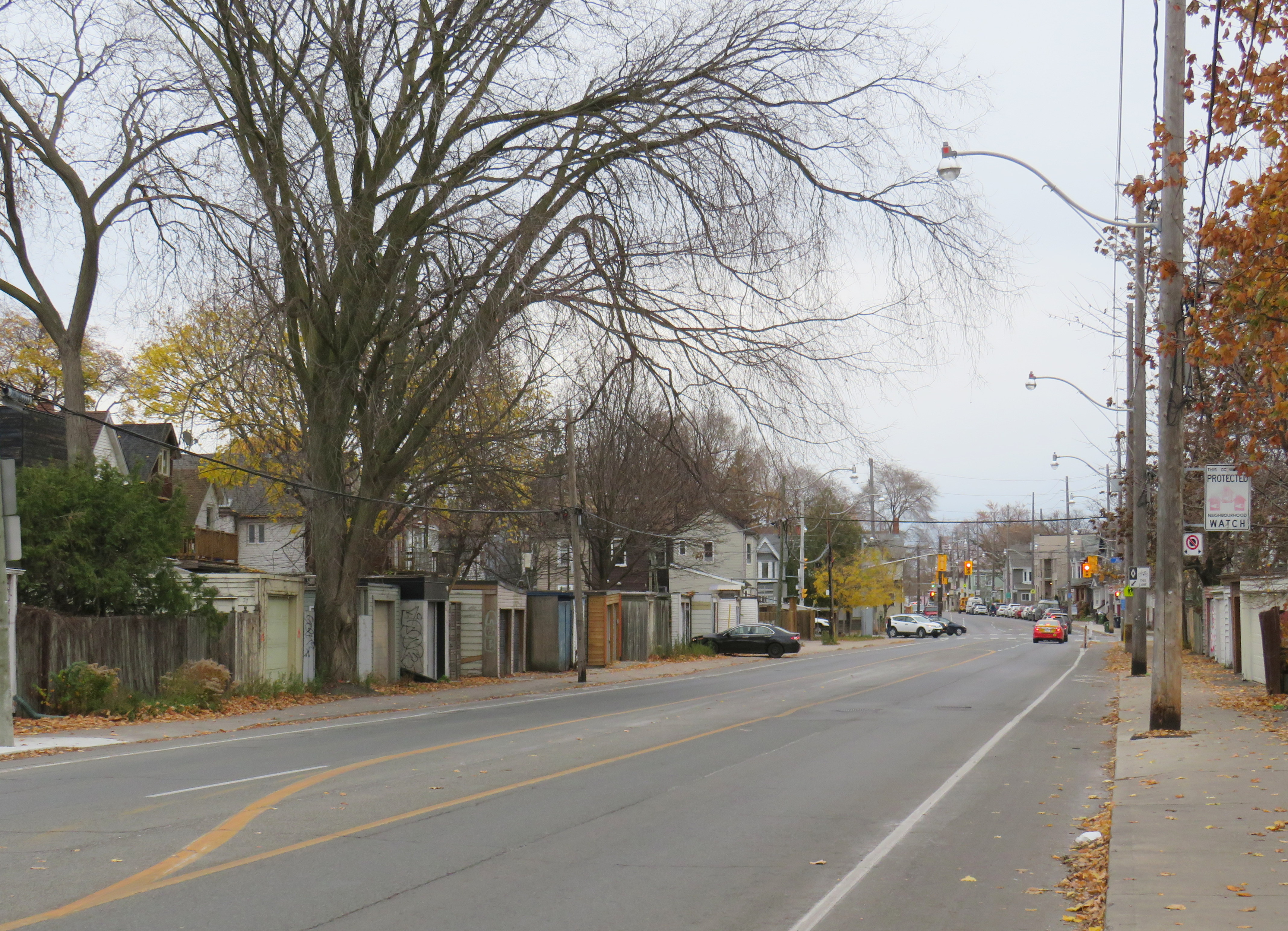
Plan for Dundas Street extension through the rear yards and laneway between Dagmar and Mallon Avenues. From City of Toronto Archives, Fonds 200, Series 2277, Item 32.Just west of Jones Avenue, Dundas Street East is lined with garages, as it passes through an old alley between Dagmar and Mallon Avenues.
Though Dundas Street East was shoehorned into several east-end neighbourhoods through the 1940s and 1950s to provide a new route for automobile traffic, over fifty years later it became an important cycling route. In 2003, the speed limit was reduced to 40 kilometres per hour, and the four traffic lanes reduced to two, with new bike lanes and a centre turning lane. Without streetcar tracks (unlike neighbouring Queen and Gerrard Streets), and with few storefronts, Dundas Street was simple to reconfigure. In 2020, the bike lanes were extended west across the Don River and into Regent Park, as part of the new ActiveTO measures.
Within Toronto, Dundas Street has gone by many names: Arthur, St. Patrick, Anderson, Agnes, Wilton, Elliot, Crawford, Dagmar, Doel, Applegrove, Maughan, and Edgewood. At various times in the first half of the last century, city officials have decided to change their names to Dundas Street.
It would not be without precedent to change Dundas Street’s name as well. Henry Dundas has no connection to local history, and even the historic road that bears his name did not extend any further east than Ossington Avenue.
Retain the legal street names with additional interpretation and recognitions
Retain the legal street names but rename those civic assets with Dundas in their name, except TTC facilities (there are three parks and one library branch that include the Dundas name, and Yonge-Dundas Square; there are two TTC subway stations and one streetcar line that also bear the Dundas name)
Rename the streets and all other civic assets now carrying the Dundas name (including Dundas Street East, Dundas Street West, Dundas Square, and Old Dundas Street).
I would agree with at least the third option, and likely the fourth option, even in part. As one of the city’s most famous and popular meeting places, a better name can be found for Yonge-Dundas Square. As Dundas Street East is a 20th century construct, and less than half the age of the historical road, it too, would be a great candidate for renaming to something meaningful. There are many other streets, towns, and parks in Toronto and elsewhere in Ontario that carry names given by early colonial officials, eager to leave their mark on newly claimed lands. Some are also worthy candidates for renaming.
Other municipalities, including Mississauga, Oakville, Burlington, Woodstock, and London, will also have to decide what they will do with their sections of Dundas Street. There is also the matter of the former Town of Dundas, the Dundas Valley, the United Counties of Stormont, Dundas, and Glengarry in Eastern Ontario (and two townships within it). There are also Dundas Streets in Belleville, Trenton, and Napanee along Highway 2, but otherwise unrelated to the historic road.
But the process must be thoughtful and considerate, and not just a another feel-good exercise that distracts from the real economic and racial inequities in our city.
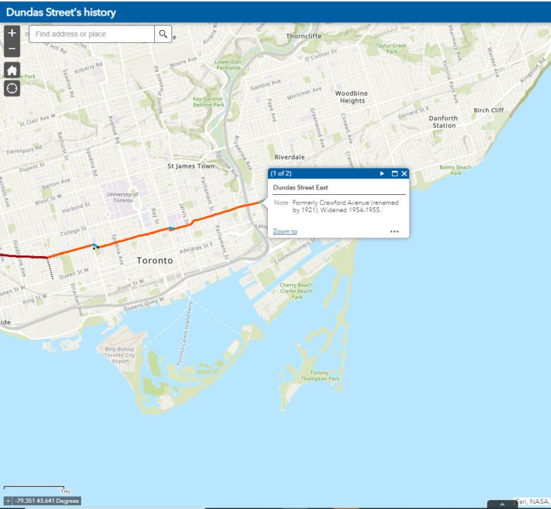
The interactive map below illustrates the history of Dundas Street, from London to Kingston Road.
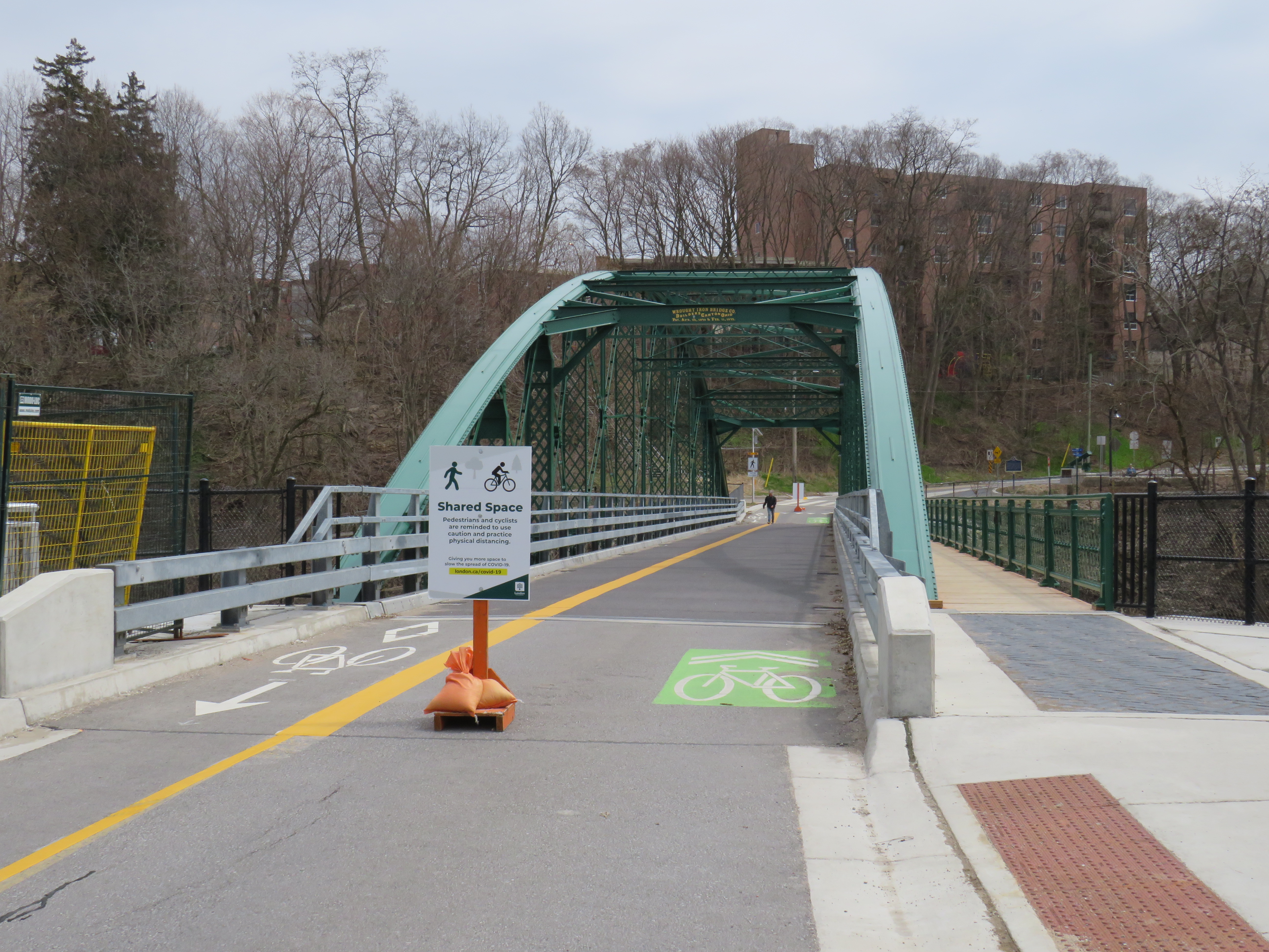
Blackfriars Bridge open to pedestrians and cyclists in London, Ontario
For my latest TVO article, I spoke with Councillor Shawn Menard in Ottawa, Councillor Rowena Santos in Brampton, and Ryerson University epidemiologist Anne Harris about how cities in Ontario are reallocating road space for pedestrians and cyclists during the ongoing COVID-19 pandemic, or why they may be hesitant to do so.
In Brampton, five kilometres of new bike lanes, proposed in that city’s new transportation plan, were quickly approved as part of its response to COVID-19. This benefits both pedestrians and cyclists by reducing conflicts on sidewalks, reducing congestion on city paths, and recognizing that cycling is an increasingly important mode of transportation.
Cyclists on Howden Boulevard, Brampton
In Ottawa, despite resistance from the the mayor and council, Shawn Menard, who represents an urban ward just south of Parliament Hill, was able to temporarily close two lanes of traffic on a narrow bridge on a major retail street, and worked with the National Capital Commission to re-allocate a section of parkway for active transportation.
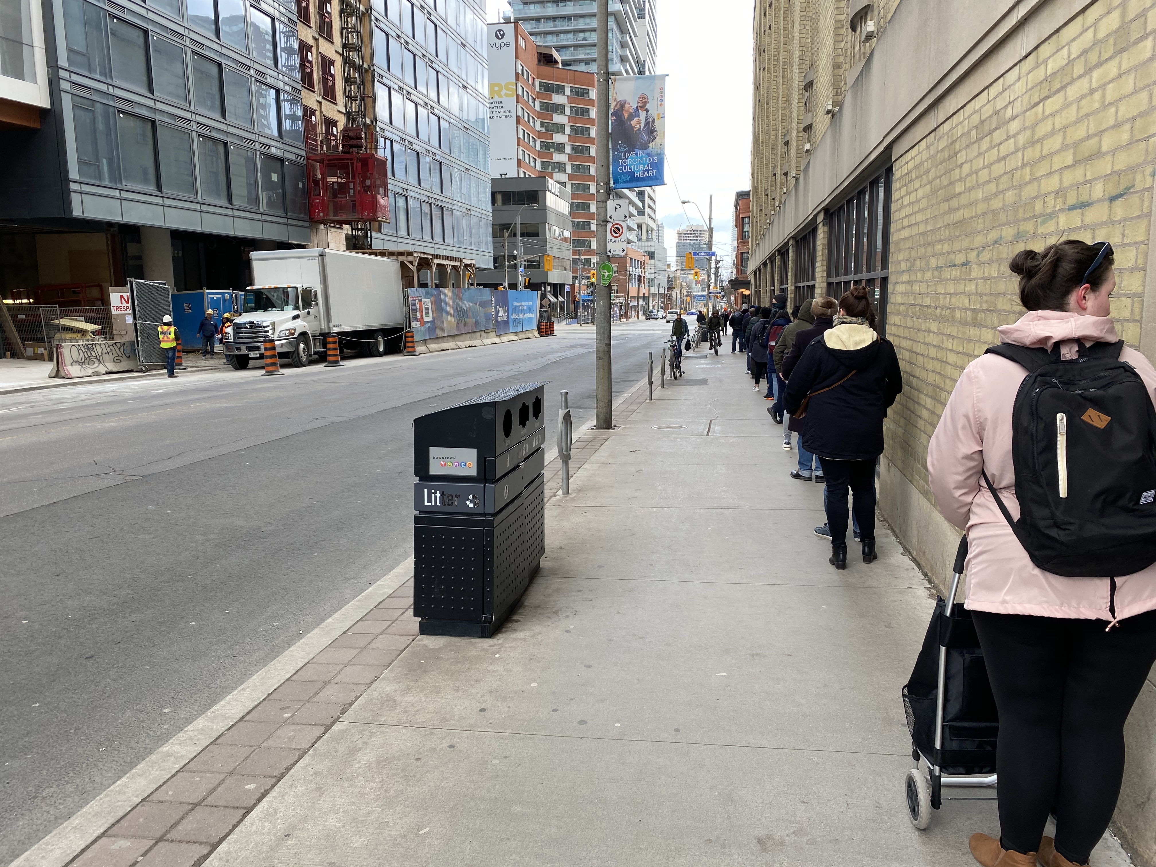
Meanwhile in Toronto, the mayor and medical officer of health were resistant to increasing calls for sidewalk expansions in congested urban areas, including where queues formed to enter grocery stores, pharmacies, hardware stores, and LCBO outlets.
Queue on Church Street at Carlton to enter Loblaws supermarket
With Walk Toronto, I have been involved with pushing the City of Toronto to take action, especially in pinch points where store queues, construction barriers, and other obstructions have made it difficult — if not impossible — to safely practice physical distancing when walking or cycling for essential purposes, or even getting a little bit of fresh air or light exercise in dense urban areas.
The good news is that ten problem areas — including the intersection of Carlton and Church — have finally been identified for curb lane closures, with potentially more on the way. This is a timid first step, made after weeks of advocacy, but it is welcome.
Unfortunately, there have also been some setbacks. Wroute, a shared taxi service in the Kitchener-Guelph-Hamilton triangle, was operational for less than a year. Though GO Transit added new weekday trains between Guelph and Kitchener, none allow for Kitchener-bound commutes, and there has not been interest in serving those gaps identified by Wroute.
Outside of Northern Ontario and the Golden Horseshoe, many cities and towns remain disconnected from nearby communities and larger centres. Though every city and town in Ontario had daily bus and/or rail service in the 1980s, many communities are now completely inaccessible for anyone without access to a car. Though GO Transit expanded to Peterborough, Brantford, Niagara, and Kitchener in the last fifteen years, they are extensions of GO’s radial network from Toronto rather than a true intercity network.
St. Thomas, population 41,000, is the largest city in the province without any passenger links, despite being a short drive to London. Many other cities and towns — particularly in Midwestern and Eastern Ontario — find themselves in similar situations. A few other cities, such as Sarnia (which has just one train a day each way to London and Toronto), are grossly under-served.
But thanks to municipal innovation and a new provincial grant program, this is finally changing. Though several municipalities addressed this problem early on, three new inter-municipal bus systems began operations in 2019, with many more launching this year.
Early European settlers to Ontario were not very imaginative when they came up with local place names. Although some towns and townships have First Nations names (Toronto, Chinguacousy, Niagara), or named for First Nations leaders allied with the British (Tecumseh, Brant), most cities, towns, and townships were given the names of European settlements, British royals and nobility, or the names of those settlers.
The list of Ontario towns and cities includes no less than ten world capitals: Athens, Brussels, Delhi, Dublin, London, Paris, Vienna, Warsaw, Wellington, and Zurich. Other towns and cities across the province include the names of British royalty and nobility (Cobourg, Hanover, Port Arthur, Fort William, Richmond Hill) or the towns settler arrived from. These towns can be found throughout the province.
At Clappison’s Corners, a busy intersection outside of Hamilton, Paris and London appear on the same sign, amusing the occasional visitor. By driving west on Highway 5, Paris is just 42 kilometres away, with London an additional 80 kilometres’ drive via Highway 2.
The other Covent Garden Market, London
London was named for the British city in 1793, and was chosen as the site of the new capital of Upper Canada by governor John Graves Simcoe. He felt that the interior location, on the banks of the Thames River (Simcoe named that, too), would be safe from American attack. However, York (now Toronto), became the capital. But London became the regional centre for Western Ontario, and is now the world’s second-largest London with over 350,000 residents.
Paris, Ontario’s main street backs onto the Grand River
Paris was named in the 1840s not for the French capital, but for the large gypsum deposits in the area, used to make plaster of Paris. In 2000, the town of Paris was amalgamated with rural Brant County. The community has a population of just 12,000, the third-largest Paris (between Paris, Texas and Paris, Tennessee).
Before the provincial government downloaded thousands of highways to local municipalities in the late 1990s, Highway 5 ran from Highway 2 (Kingston Road) in Scarborough to Highway 2 again at Paris. At Paris, a motorist could continue on Highway 2 west to London and beyond. New freeways, such as Highway 403, offered a faster trip, while local roads, such as Highways 2 and 5, were downloaded as a cost-cutting measure. Today, Highway 5 runs for just 13 kilometres connecting Highways 6 and 8.
Today, the route to Paris and London is merely an anachronism of an earlier time, when King’s Highways covered the province and when motorists passed through many small towns on their way to places like Toronto, Detroit, and Montreal. At some point, the sign at Clappison’s Corners will be removed to make way for a new interchange. Until then, this humble monument to European settlement and rural King’s Highways will stand guard.


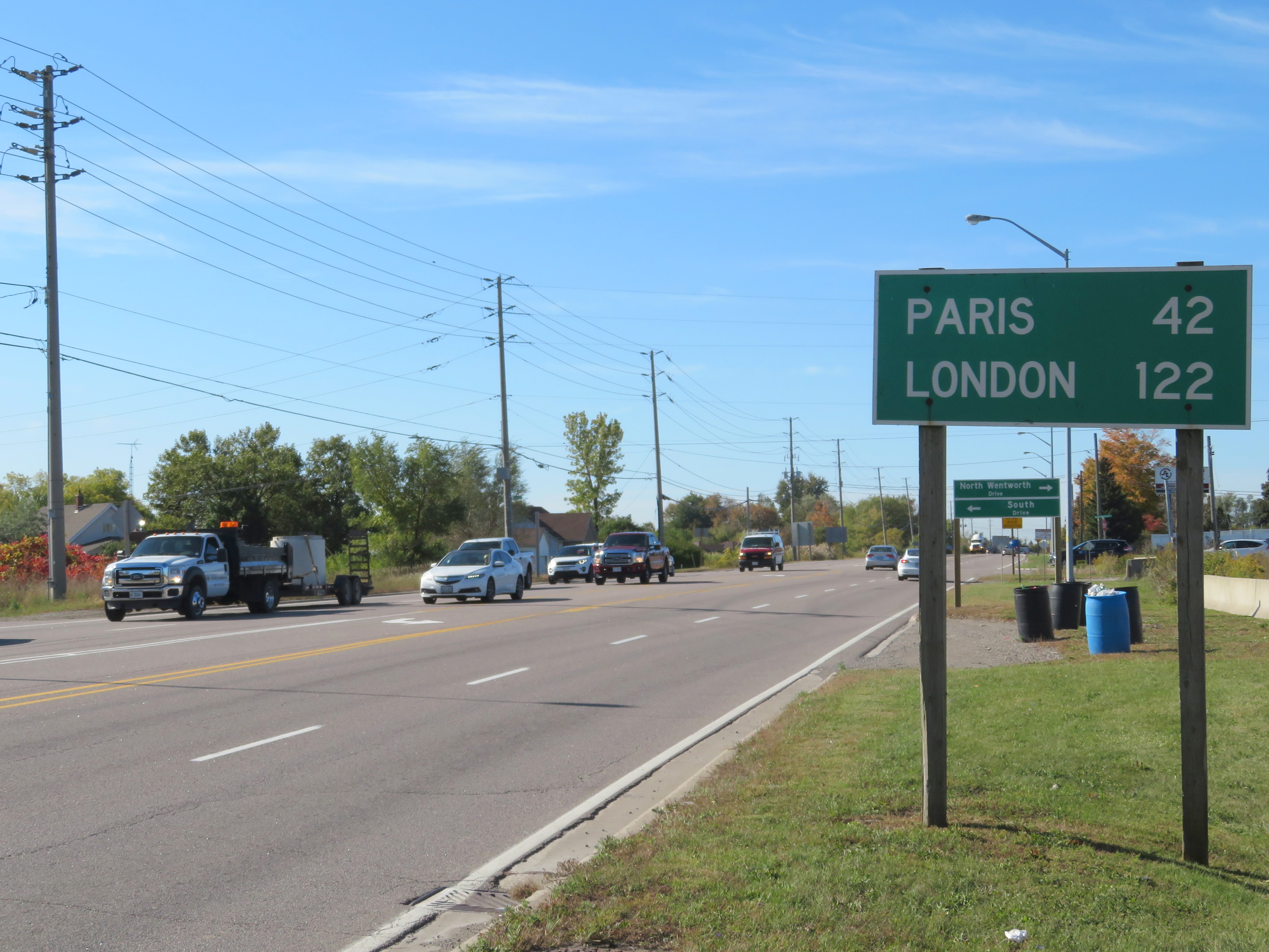 Distance Sign on Highway 5, Clappison’s Corners
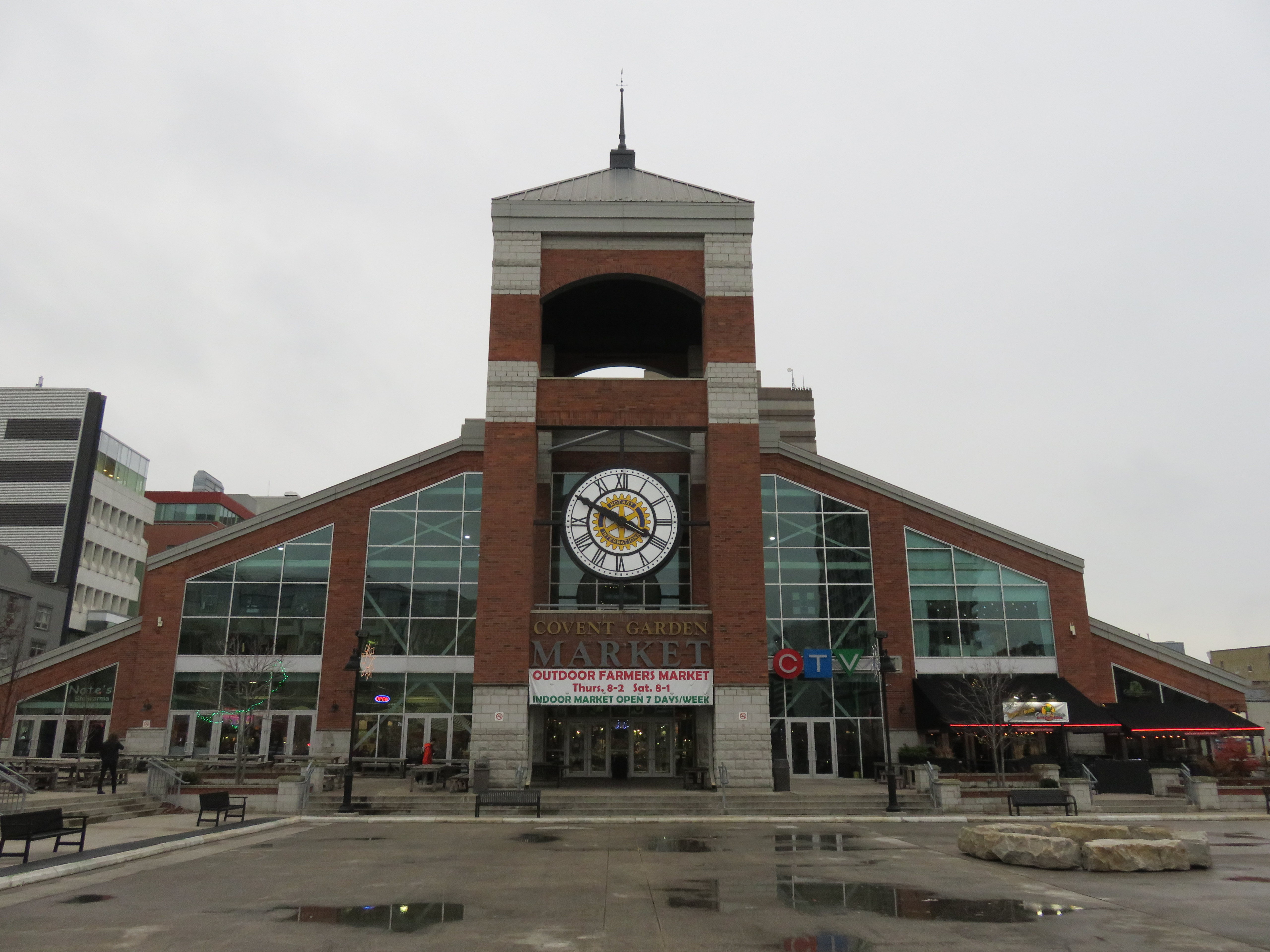 The other Covent Garden Market, London
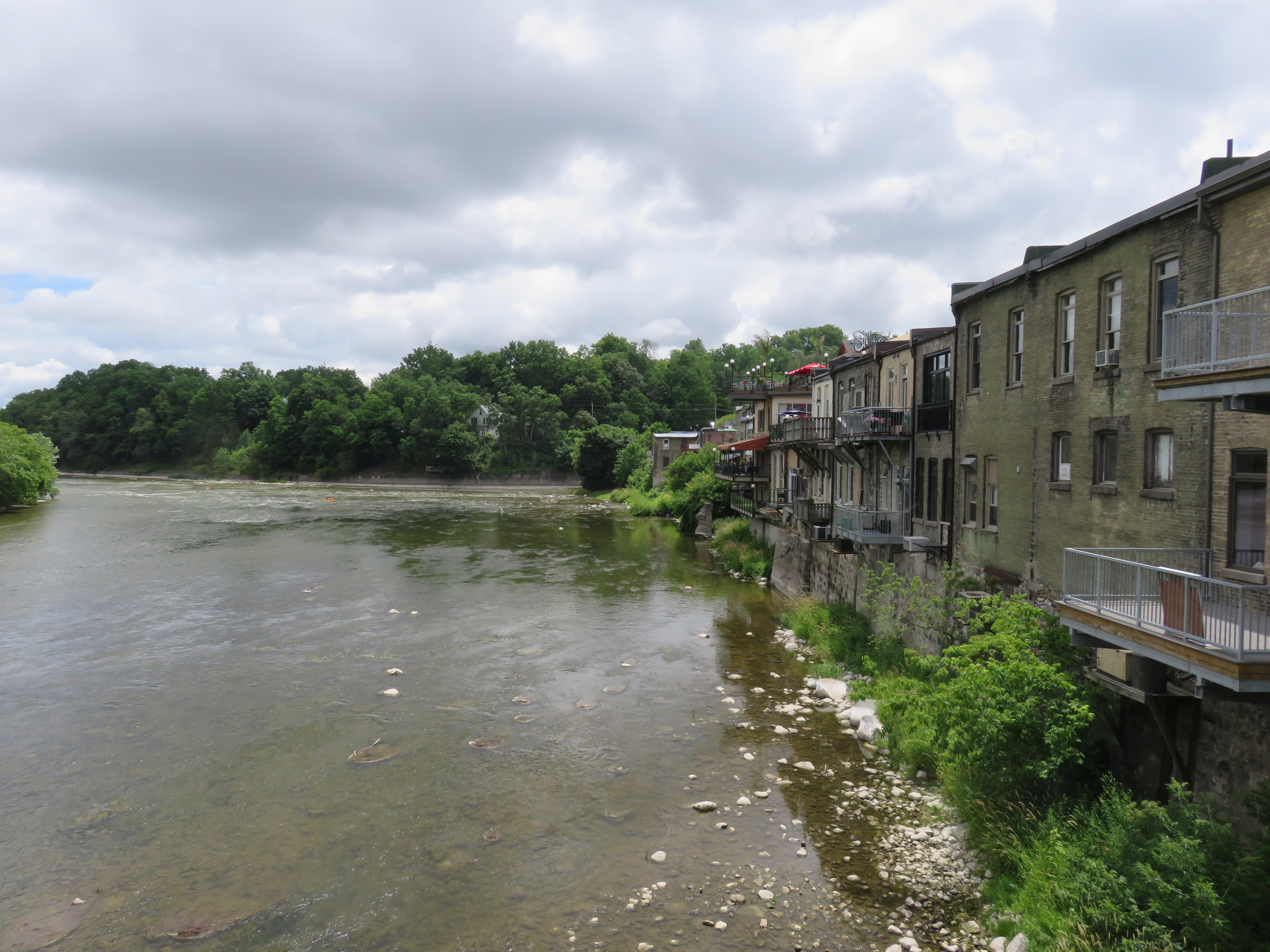 Paris, Ontario’s main street backs onto the Grand River